Khalid Y. Muwembe UGANDA NATIONAL METEOROLOGICAL AUTHORITY (UNMA)
|
|
|
- Angelina Pope
- 6 years ago
- Views:
Transcription


1 Forecasting Severe Weather over Lake Victoria region in Uganda Khalid Y. Muwembe UGANDA NATIONAL METEOROLOGICAL AUTHORITY (UNMA)
2 Outline Background Set-up of forecasting/alert service Diurnal circulation of convection over the Lake Using satellite data for monitoring convection Application of satellite and NWP products Other critical applications of satellite data A case study
3 Background The frequent recurrence of severe storms continues to threaten the safety of marine navigation over Lake Victoria since a large number of boats use the lake on a daily basis to sustain a thriving fishing industry. Hundreds of people lose their lives on the lake each year, with a significant proportion of these related to hazardous storm conditions. Given the rough weather conditions common over the lake, there was need for regular weather warnings to ensure safety of marine operations.
4 Setting up of Forecast/Alert service Taking advantage of significant improvement of weather monitoring, forecasting and communication technology in recent years. It is now possible to access necessary tools to routinely deliver forecasts/alerts of dangerous weather over the lake. UNMA set-up mobile weather alert Service designed as easy to use: daily forecasts sent by SMS to registered users each morning; and alerts whenever the weather situation worsens significantly


5 The alert service Objective Utilise mobile phone technology to develop a sustainable warning service that reduces the vulnerability of communities in the Lake Victoria Region to weather hazards. Mobile Weather Alert: Community weather information via mobile technology


6 Green Alert Yellow Alert No alert: No hazardous weather expected. Take normal precautions. Be aware: There might be changes in the weather. Be watchful and look out for signs of storm such as clouds, wind gusts, higher waves. Amber Alert Red Alert Be prepared: The weather is likely to change. Consider moving to safer areas and be prepared to take necessary actions. Take action: The weather will change soon. Take the necessary actions to get to a safe area.


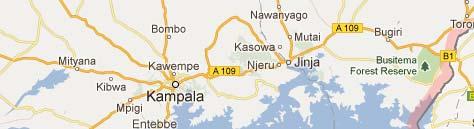
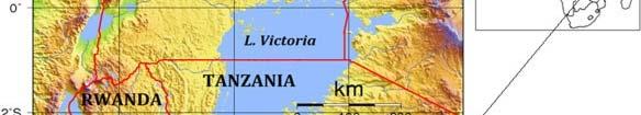
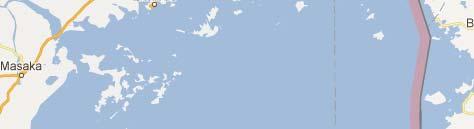
7 Focus area Fig 1: Topographic map of Uganda and location within Africa. Source: Wileyonlinelibrary.com/journal/met Fig 2: Major Islands with active fisheries over Lake Victoria. Source: Google Maps
8 Diurnal cycle of convection over the Lake Chamberlain and Bain (2012) Deep convection peaks over the lake in the early hours of the morning and dissipates in the afternoon Evening peak in convection over land north-east of the lake and to the east.
9 Using satellite data for monitoring convection


 tops Deep")


10 Using Single channel: IR 10.8 *** Forecasters able to identify areas with cold (high) tops Deep convection and ***Areas with warm tops Low level clouds on the IR10.8 image
11 Monitoring using Vis Channel From the Vis Channel more details on the cloud features can be observed
12 Colour enhanced images are useful: Convection over Lake Victoria Mid Level Clouds Kenya Democratic Republic of the Congo "Lake" Convection Tanzania Using Channel IR10.8: Deep convection can be easily distinguished from mid level clouds and Low level clouds

 -")


13 Monitoring using RGB 05-06, 04-09, 03-01: Colour Interpretation Deep precipitating cloud (precip. not necessarily reaching the ground) - high-level cloud - large ice particles Deep precipitating cloud (Cb cloud with strong updrafts and severe weather)* - high-level cloud - small ice particles *or thick, high-level lee cloudiness with small ice particles Thin Cirrus cloud (large ice particles) Thin Cirrus cloud (small ice particles)

14 RGB HRV, HRV, IR10.8 Identification of different cloud features
15 Application of Satellite and NWP Products


16 Predicted strong onshore winds causing deep convection over L. Victoria and Kyoga
17 Model-derived sounding parameters associated with severe convective storms C A PC EA P LI E High CAPE means storms will build vertically very quickly. The updraft speed depends on the CAPE environment. Downdraft: An intense updraft often produces an intense downdraft since an intense updraft will condense out a large amount of moisture. Forecasters normally expect isolated regions of very heavy rain when storms form in a large or extreme CAPE environment. Lightning: Large and extreme CAPE will Lightning: Large and extreme CAPE will produce storms with abundant lightning.


18 Model-derived sounding parameter for lightning and thunder Model-derived sounding parameters Earth networks total lightning detection Corresponding satellite image
19 Other critical application of satellite data Continuous monitoring of weather conditions across the country Preparation of TS SIGMETs for aviation Preparation of low-level significant weather charts for aviation Now casting and issuance of severe weather alerts Daily forecast verification Review of significant ifi case studies


20 Forecast verification using satellite data Observed convective storms 24-hrs cumulative ppn Forecast from 4-km L. Vic model
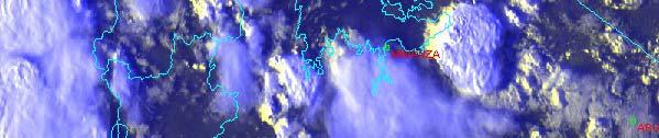
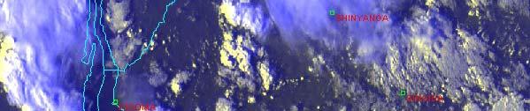
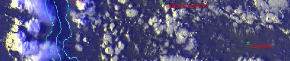
21 Case study Severe storm on 1 st March, 2012 in Buvuma area (L. Victoria) *** Three (3) Boats capsized *** Fifty (50) travelers lost lives


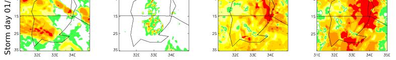
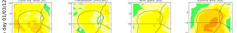
22 Satellite imagery on 1 st March 4-km Lake Victoria model T+12 Global unified model T+12 Chamberlain and Bain (2012)
23 They look keen on our service Accurate and reliable weather information saves lives
24 The End Thank you for your attention Merci
Applications of multi-spectral satellite data
 Applications of multi-spectral satellite data Jochen Kerkmann EUMETSAT, Satellite Meteorologist, Training Officer Adjusted by E de Coning South African Weather Service Content 1. Why should we use RGBs?
How to display RGB imagery by SATAID
 How to display RGB imagery by SATAID Akihiro SHIMIZU Meteorological Satellite Center (MSC), Japan Meteorological Agency (JMA) Ver. 2015110500 RGB imagery on SATAID SATAID software has a function of overlapping
Day Microphysics RGB Nephanalysis in daytime. Meteorological Satellite Center, JMA
 Day Microphysics RGB Nephanalysis in daytime Meteorological Satellite Center, JMA What s Day Microphysics RGB? R : B04 (N1 0.86) Range : 0~100 [%] Gamma : 1.0 G : B07(I4 3.9) (Solar component) Range :
MSG FOR NOWCASTING - EXPERIENCES OVER SOUTHERN AFRICA
 MSG FOR NOWCASTING - EXPERIENCES OVER SOUTHERN AFRICA Estelle de Coning and Marianne König South African Weather Service, Private Bag X097, Pretoria 0001, South Africa EUMETSAT, Am Kavalleriesand 31, D-64295
Module 11: Meteorology Topic 5 Content: Weather Maps Notes
 Introduction A variety of weather maps are produced by the National Weather Service and National Oceanographic Atmospheric Administration. These maps are used to help meteorologists accurately predict
THUNDERSTORMS Brett Ewing October, 2003
 THUNDERSTORMS Brett Ewing October, 2003 A natural hazard that occurs often on a daily basis in the lower and mid-latitudes is thunderstorms. Thunderstorms is a weather system that can produce lightning,tornadoes,
Meteorology. Chapter 10 Worksheet 2
 Chapter 10 Worksheet 2 Meteorology Name: Circle the letter that corresponds to the correct answer 1) Downdrafts totally dominate the in the development of a thunderstorm. a) dissipating stage b) mature
Model enhancement & delivery plans, RAI
 Model enhancement & delivery plans, RAI Karen McCourt, UK VCP Manager 12 th June 2013 Outline Current model outputs & dissemination Future model outputs & dissemination New website for dissemination to
World Meteorological Organization Working together in weather, climate and water
 WMO World Meteorological Organization Working together in weather, climate and water Strengthening Regional Cooperation to Support Forecasting with Multi-Hazard Approach in RA IV SWFDP concepts and lessons
Unit 5 Lesson 3 How is Weather Predicted? Copyright Houghton Mifflin Harcourt Publishing Company
 Tracking the Weather Warm up 1 Why is it important to watch the weather forecast before traveling to another country? Tracking the Weather A meteorologist is a scientist who studies weather. Meteorologists
Air Mass Thunderstorms. Air Mass Thunderstorms. Air Mass Thunderstorms. Lecture 26 Air Mass Thunderstorms and Lightning
 Lecture 26 and Lightning Life Cycle Environment Climatology Lightning 1 2 Short-lived, isolated thunderstorms that are not severe are often called air-mass thunderstorms. There are three stages describing
HAZARDOUS WEATHER 1. Dr. Julie Laity Geography 266
 HAZARDOUS WEATHER 1 Dr. Julie Laity Geography 266 Violent Weather Thunderstorms Atmospheric turbulence Lightning and thunder Hail Derechos Tornadoes Tornado measurement and science Tropical Cyclones Hurricanes
LVB-HYNEWS CONSORTIUM LAKE VICTORIA PROJECT
 LVB-HYNEWS CONSORTIUM LAKE VICTORIA PROJECT Outline The East African Community Background Heads of EAC NMHS meeting EAC East African Community Burundi, Kenya, Rwanda, Tanzania, Uganda John Mungai, EAC
Weather. Weather Patterns
 Weather Weather Patterns What do you think? Read the two statements below and decide whether you agree or disagree with them. Place an A in the Before column if you agree with the statement or a D if you
The importance of satellite data for nowcasting in the WWRP strategy
 The importance of satellite data for nowcasting in the WWRP strategy Estelle de Coning and Paolo Ruti World Weather Research Division Steve Goodman Chief Program Scientist, NOAA WMO definition Nowcasting
The importance of satellite data and products for RA1 in the WWRP strategy. Estelle de Coning World Weather Research Division
 The importance of satellite data and products for RA1 in the WWRP strategy Estelle de Coning World Weather Research Division Kofi Annan former UN Secretary-General (21 July 2016) "The poor need alerts
Nowcasting of Severe Weather from Satellite Images (for Southern
 Nowcasting of Severe Weather from Satellite Images (for Southern Europe) Petra Mikuš Jurković Forecasting/ nowcasting of convective storms NWP models cannot well predict the exact location and intesity
Weather - is the state of the atmosphere at a specific time & place
 Weather Section 1 Weather - is the state of the atmosphere at a specific time & place Includes such conditions as air pressure, wind, temperature, and moisture in the air The Sun s heat evaporates water
Chapter Introduction. Weather. Patterns. Forecasts Chapter Wrap-Up
 Chapter Introduction Lesson 1 Lesson 2 Lesson 3 Describing Weather Weather Patterns Weather Forecasts Chapter Wrap-Up How do scientists describe and predict weather? What do you think? Before you begin,
Weather Systems. The air around high-pressure weather systems tends to swirl in a clockwise direction, and usually brings clear skies.
 Weather Systems A weather system is a set of temperature, wind, pressure, and moisture conditions for a certain region that moves as a unit for a period of several days. Low-pressure weather systems form
Weather Pattern Notes
 Weather Pattern Notes Please copy notes into you notebooks on pgs 72,74, and 76. Include 3 Questions that your notes answer on EACH of the pages you have notes on for full credit. Lesson 2-1 Pressure Systems
Use the terms from the following list to complete the sentences below. Each term may be used only once.
 Skills Worksheet Directed Reading Section: Air Masses Use the terms from the following list to complete the sentences below. Each term may be used only once. high pressure poles low pressure equator wind
Counselor s Name: Counselor s Ph #: 1) Define meteorology. Explain how the weather affects farmers, sailors, aviators,
 Define meteorology. Explain how the weather affects farmers, sailors, aviators,") Weather Merit Badge Workbook This workbook is not required but is designed to help you with this merit badge. No one can add or subtract from the Boy Scout Requirements #33215. Use page backs & add pages
Weather Merit Badge Workbook This workbook is not required but is designed to help you with this merit badge. No one can add or subtract from the Boy Scout Requirements #33215. Use page backs & add pages
Aviation Hazards: Thunderstorms and Deep Convection
 Aviation Hazards: Thunderstorms and Deep Convection TREND Empirical thunderstorm forecasting techniques Contents Necessary conditions for convection: Instability Low-level moisture Trigger mechanism Forecasting
Regional Hazardous Weather Advisory Centres (RHWACs)
") Regional Hazardous Weather Advisory Centres (RHWACs) The following outlines the criteria for the selection of RHWACs based on operational and functional requirements 1. Basic Principles The RHWAC must:
Regional Hazardous Weather Advisory Centres (RHWACs) The following outlines the criteria for the selection of RHWACs based on operational and functional requirements 1. Basic Principles The RHWAC must:
July 24, 2017 Annapolis, MD Bryan A. Jackson NWS Sterling, VA Marine Program Leader
 When Wicked Weather Strikes Insights into Chesapeake Bay Weather July 24, 2017 Annapolis, MD Bryan A. Jackson NWS Sterling, VA Marine Program Leader Mission of the National Weather Service Provide climate,
Joseph Kagenyi Principal Meteorologist (RS/GIS) IMTR-NAIROBI 13 th UFA September 2018
 IMTR-NAIROBI 13 th UFA September 2018") Joseph Kagenyi Principal Meteorologist (RS/GIS) IMTR-NAIROBI 13 th UFA 24-28 September 2018 kagenyijn@gmail.com 1. PUMA WorkStation structure 2. Data Available on PUMA Station 3. PUMA Nowcasting Applications
Joseph Kagenyi Principal Meteorologist (RS/GIS) IMTR-NAIROBI 13 th UFA 24-28 September 2018 kagenyijn@gmail.com 1. PUMA WorkStation structure 2. Data Available on PUMA Station 3. PUMA Nowcasting Applications
Scout s Address: City State Zip:
 WEATHER BYU Merit Badge Pow Wow Official Merit Badge Worksheet New 2014 Requirements Scout s Name: Instructor s Name: Scout s Address: City State Zip: Instructions 1. The Scout is to review the merit badge
Chapter 14 Thunderstorm Fundamentals
 Chapter overview: Thunderstorm appearance Thunderstorm cells and evolution Thunderstorm types and organization o Single cell thunderstorms o Multicell thunderstorms o Orographic thunderstorms o Severe
Module 11: Meteorology Topic 6 Content: Severe Weather Notes
 Severe weather can pose a risk to you and your property. Meteorologists monitor extreme weather to inform the public about dangerous atmospheric conditions. Thunderstorms, hurricanes, and tornadoes are
Mr. P s Science Test!
 WEATHER- 2017 Mr. P s Science Test! # Name Date 1. Draw and label a weather station model. (10 pts) 2. The is the layer of the atmosphere with our weather. 3. Meteorologists classify clouds in about different
Weather Unit Part 2: Meteorology
 Name: Earth Science Date: Period: Weather Unit Part 2: Meteorology 1 The map below shows North America and its surrounding bodies of water. Country borders are shown. On the map, label the following locations:
T-re Plots Generated from MSG Data in Severe Storms Forecasting Testing in Central Europe
 WDS'11 Proceedings of Contributed Papers, Part III, 88 92, 2011. ISBN 978-80-7378-186-6 MATFYZPRESS T-re Plots Generated from MSG Data in Severe Storms Forecasting Testing in Central Europe M. Pokorný
Severe weather. Some case studies for medium-range forecasting. T. La Rocca, Department of Synoptic Meteorology, Italian Met. Service, Rome.
 Severe weather. Some case studies for medium-range forecasting T. La Rocca, Department of Synoptic Meteorology, Italian Met. Service, Rome. The Met Alert Messages by the Watch Office of the Public Safety
Introduction to African weather
 Introduction to African weather Dr Caroline Bain Met Office, Exeter, UK Overview Convection and general circulation A tour around the seasons: West African Monsoon, AEWs, Short rains East Africa, Low-level
Thunderstorms. Stages in the development of a thunderstorm
 Severe Weather Outcomes: S2-4-04 Explain the formation and dynamics of selected severe weather phenomena... S2-4-05 Collect, interpret, and analyze meteorological data related to a severe weather event.
Regional Hazardous Weather Advisory Centres (RHWACs)
") Regional Hazardous Weather Advisory Centres (RHWACs) The following outlines the criteria for the selection of RHWACs based on operational and functional requirements 1. Basic Principles The RHWAC must:
Regional Hazardous Weather Advisory Centres (RHWACs) The following outlines the criteria for the selection of RHWACs based on operational and functional requirements 1. Basic Principles The RHWAC must:
Tornadoes. tornado: a violently rotating column of air
 Tornadoes tornado: a violently rotating column of air Tornadoes What is the typical size of a tornado? What are typical wind speeds for a tornado? Five-stage life cycle of a tornado Dust Swirl Stage Tornado
Understanding Weather and Climate Risk. Matthew Perry Sharing an Uncertain World Conference The Geological Society, 13 July 2017
 Understanding Weather and Climate Risk Matthew Perry Sharing an Uncertain World Conference The Geological Society, 13 July 2017 What is risk in a weather and climate context? Hazard: something with the
Smart use of Geographic Information System (GIS) platform for delivering weather information and nowcasting services
 platform for delivering weather information and nowcasting services") Smart use of Geographic Information System (GIS) platform for delivering weather information and nowcasting services C. K. Pan Hong Kong Observatory Hong Kong, China It is a world of beauty Source: Image
Smart use of Geographic Information System (GIS) platform for delivering weather information and nowcasting services C. K. Pan Hong Kong Observatory Hong Kong, China It is a world of beauty Source: Image
Wind Events. Flooding Events. T-Storm Events. Awareness Alerts / Potential Alerts / Action Alerts / Immediate Action Alerts / Emergency Alerts.
 Information Updated: February of 2016 Our Alert Terms Definitions * Use exactly as seen below * Wind Events Awareness Alert - Strong Winds Potential Alert - Damaging Winds ACTION Alert - Damaging Winds
Jim Witt Long Range Calendar
 Jim Witt Long Range Calendar 2012-2013 November 2012 Toll Free 1-0-287-03 Studio Line (207) 9- Generally 20 40 50 60 70 0 Generally Cloudy, Cool Change Of Rain Or Wet Snow (Heavy) Changing To Rain 1 120
International Cooperation in Operational Environmental Satellites: The U.S. Experience
 Committee on the Peaceful Uses of Outer Space Science and Technology Sub committee Forty seventh session February 17, 2010 Vienna, Austria International Cooperation in Operational Environmental Satellites:
Weather Merit Badge Workbook
 Merit Badge Workbook This workbook can help you but you still need to read the merit badge pamphlet. This Workbook can help you organize your thoughts as you prepare to meet with your merit badge counselor.
What do you think of when someone says weather?
 Weather Our World: What is Weather? video What do you think of when someone says weather? Questions from Bill Nye video 1. What causes wind? 2. What are two things that were mentioned by Bill Nye that
Weather Patterns and Severe Storms
 Weather Patterns and Severe Storms 20.1 Air Masses Air Masses and Weather Air Masses An air mass is an immense body of air that is characterized by similar temperatures and amounts of moisture at any given
Regional Flash Flood Guidance and Early Warning System
 WMO Training for Trainers Workshop on Integrated approach to flash flood and flood risk management 24-28 October 2010 Kathmandu, Nepal Regional Flash Flood Guidance and Early Warning System Dr. W. E. Grabs
Catalysing Innovation in Weather Science - the role of observations and NWP in the World Weather Research Programme
 Catalysing Innovation in Weather Science - the role of observations and NWP in the World Weather Research Programme Estelle de Coning, Paolo Ruti, Julia Keller World Weather Research Division The World
Severe Weather. Copyright 2006 InstructorWeb
 Severe Weather People need to know what the weather is going to do. Sometimes severe weather can happen. Severe weather can cause property damage, injuries to people and animals, and even loss of life.
Guided Notes Weather. Part 2: Meteorology Air Masses Fronts Weather Maps Storms Storm Preparation
 Guided Notes Weather Part 2: Meteorology Air Masses Fronts Weather Maps Storms Storm Preparation The map below shows North America and its surrounding bodies of water. Country borders are shown. On the
Severe Weather Watches, Advisories & Warnings
 Severe Weather Watches, Advisories & Warnings Tornado Watch Issued by the Storm Prediction Center when conditions are favorable for the development of severe thunderstorms and tornadoes over a larger-scale
Unit 4 Review Guide: Weather
 Unit 4 Review Guide: Weather Weather: The condition of the atmosphere at a specific time and place. Freezing: To become hardened into ice or into a solid body Deposition: The change in state of matter
Detection and Monitoring Convective Storms by. Using MSG SEVIRI Image. Aydın Gürol ERTÜRK. Contents
 Detection and Monitoring Convective Storms by 1 Using MSG SEVIRI Image Contents MSGView Software Cold U/V and Ring Shape Storm Tops Case Study, 2nd April 2011 Antalya, Türkiye Conclusion Aydın Gürol ERTÜRK
Tropical Update. 5 AM EDT Wednesday, September 6, 2017 Hurricane Irma, Tropical Storm Jose, and Tropical Storm Katia
 Tropical Update 5 AM EDT Wednesday, September 6, 2017 Hurricane Irma, Tropical Storm Jose, and Tropical Storm Katia This update is intended for government and emergency response officials, and is provided
Guided Reading Chapter 18: Weather Patterns
 Name Number Date Guided Reading Chapter 18: Weather Patterns 18-1: Air Masses and Fronts 1. What is an air mass? 2. Scientists classify air masses according to and 3. Is the following sentence true or
Marine Weather Primer
 1 of 73 Marine Weather Primer Mark A. Thornton LakeErieWX: Marine Weather Education and Forecasting Resources Mark@LakeErieWX.com 2 of 73 3 of 73 Marine Weather Seminars & Workshops Learn a little meteorology
3 Weather and Climate
 CHAPTER 22 3 Weather and Climate SECTION The Atmosphere KEY IDEAS As you read this section, keep these questions in mind: What are fronts? What are some types of severe weather? How is climate different
Chapter 21. Weather Patterns and Severe Storms
 Chapter 21 Weather Patterns and Severe Storms 20.1 Air Masses Air Masses and Weather Air Masses An air mass is an immense body of air that is characterized by similar temperatures and amounts of moisture
South African Weather Service. Description of Public Weather and Warning Services. Tshepho Ngobeni. 18 November 2013
 South African Weather Service Description of Public Weather and Warning Services Tshepho Ngobeni 18 November 2013 SAWS-SWFDP_PRES_18-22_Nov_2013 1 Outline Forecasting Descriptions and Processes Severe
DEPARTMENT OF EARTH & CLIMATE SCIENCES SAN FRANCISCO STATE UNIVERSITY. Metr Fall 2014 Test #1 September 30, 2014
 DEPARTMENT OF EARTH & CLIMATE SCIENCES SAN FRANCISCO STATE UNIVERSITY NAME Metr 302.02 Fall 2014 Test #1 September 30, 2014 200 pts (4 pts each answer) Part I. Surface Chart Interpretation. Questions 1
Tropical Update. 5 AM EDT Thursday, September 7, 2017 Hurricane Irma, Hurricane Jose, and Hurricane Katia
 Tropical Update 5 AM EDT Thursday, September 7, 2017 Hurricane Irma, Hurricane Jose, and Hurricane Katia This update is intended for government and emergency response officials, and is provided for informational
LECTURE #15: Thunderstorms & Lightning Hazards
 GEOL 0820 Ramsey Natural Disasters Spring, 2018 LECTURE #15: Thunderstorms & Lightning Hazards Date: 1 March 2018 (lecturer: Dr. Shawn Wright) I. Severe Weather Hazards focus for next few weeks o somewhat
Deep Thunder. Local Area Precision Forecasting for Weather-Sensitive Business Operations (e.g. Electric Utility)
") 1 Deep Thunder Local Area Precision Forecasting for Weather-Sensitive Business Operations (e.g. Electric Utility) Dipl. Ing. Helmut Ludwar Chief Technologist Wien, im Oktober 2010 Forecasts for Weather-Sensitive
1 Deep Thunder Local Area Precision Forecasting for Weather-Sensitive Business Operations (e.g. Electric Utility) Dipl. Ing. Helmut Ludwar Chief Technologist Wien, im Oktober 2010 Forecasts for Weather-Sensitive
Hurricane Recipe. Hurricanes
 Hurricanes A hurricane is a powerful, rotating storm that forms over warm oceans near the Equator. Hurricanes have strong, rotating winds (at least 74 miles per hour), a huge amount of rain, low air pressure,
ESCI 344 Tropical Meteorology Lesson 7 Temperature, Clouds, and Rain
 ESCI 344 Tropical Meteorology Lesson 7 Temperature, Clouds, and Rain References: Forecaster s Guide to Tropical Meteorology (updated), Ramage Tropical Climatology, McGregor and Nieuwolt Climate and Weather
How strong does wind have to be to topple a garbage can?
 How strong does wind have to be to topple a garbage can? Imagine winds powerful enough to pick up a truck and toss it the length of a football field. Winds of this extreme sometimes happen in a tornado.
III. Section 3.3 Vertical air motion can cause severe storms
 III. Section 3.3 Vertical air motion can cause severe storms http://www.youtube.com/watch?v=nxwbr60tflg&feature=relmfu A. Thunderstorms form from rising moist air Electrical charges build up near the tops
Ch. 3: Weather Patterns. Sect. 1: Air Mass & Fronts Sect. 2: Storms Sect. 3: Predicting the Weather
 Ch. 3: Weather Patterns Sect. 1: Air Mass & Fronts Sect. 2: Storms Sect. 3: Predicting the Weather Sect. 1: Air Masses & Fronts An air mass is a huge body of air that has similar temperature, humidity,
Weather 101 Brad Jakubowski Doane College Water
 Weather 101 Fundamental Meteorology for Turf Managers Brad Jakubowski Doane College Do Baseballs Really Fly Farther at Coors Field? In theory, A well struck baseball should travel 10 percent farther at
INCA CE: Integrating Nowcasting with crisis management and risk prevention in a transnational framework
 INCA CE: Integrating Nowcasting with crisis management and risk prevention in a transnational framework Yong Wang ZAMG, Austria This project is implemented through the CENTRAL EUROPE Programme co-financed
Application and verification of ECMWF products at the Finnish Meteorological Institute
 Application and verification of ECMWF products 2010 2011 at the Finnish Meteorological Institute by Juhana Hyrkkènen, Ari-Juhani Punkka, Henri Nyman and Janne Kauhanen 1. Summary of major highlights ECMWF
WEATHER FORECASTING Acquisition of Weather Information WFO Regions Weather Forecasting Tools Weather Forecasting Tools Weather Forecasting Methods
 1 2 3 4 5 6 7 8 WEATHER FORECASTING Chapter 13 Acquisition of Weather Information 10,000 land-based stations, hundreds of ships and buoys; four times a day, airports hourly Upper level: radiosonde, aircraft,
Numerical Simulation of a Severe Thunderstorm over Delhi Using WRF Model
 International Journal of Scientific and Research Publications, Volume 5, Issue 6, June 2015 1 Numerical Simulation of a Severe Thunderstorm over Delhi Using WRF Model Jaya Singh 1, Ajay Gairola 1, Someshwar
For further information, and additional background on the American Meteorological Society s Education Program, please contact:
 Project ATMOSPHERE This guide is one of a series produced by Project ATMOSPHERE, an initiative of the American Meteorological Society. Project ATMOSPHERE has created and trained a network of resource agents
Issue of SIGMET/AIRMET warning part II
 Issue of SIGMET/AIRMET warning part II 1 SIGMET SIGMET is warning information and hence it is of highest priority amongst other types of meteorological information provided to the aviation users. This
National Maritime Center
 National Maritime Center Providing Credentials to Mariners (Sample Examination) Page 1 of 5 Choose the best answer to the following Multiple Choice Questions. 1. In a weather report, the term "visibility"
3 Severe Weather. Critical Thinking
 CHAPTER 2 3 Severe Weather SECTION Understanding Weather BEFORE YOU READ After you read this section, you should be able to answer these questions: What are some types of severe weather? How can you stay
National Public Weather and Warning Services in the Swaziland Meteorological Service Dennis S.Mkhonta /
 National Public Weather and Warning Services in the Swaziland Meteorological Service Dennis S.Mkhonta dennis.mkhonta@gmail.com / dennis@swazimet.gov.sz Introduction Swaziland s geographical position exposes
TOPICS: What are Thunderstorms? Ingredients Stages Types Lightning Downburst and Microburst
 THUNDERSTORMS TOPICS: What are Thunderstorms? Ingredients Stages Types Lightning Downburst and Microburst What are Thunderstorms? A storm produced by a cumulonimbus cloud that contains lightning and thunder
GEOGRAPHY EYA NOTES. Weather. atmosphere. Weather and climate
 GEOGRAPHY EYA NOTES Weather and climate Weather The condition of the atmosphere at a specific place over a relatively short period of time Climate The atmospheric conditions of a specific place over a
The known requirements for Arctic climate services
 The known requirements for Arctic climate services based on findings described in STT White paper 8/2015 Johanna Ekman / EC PHORS STT Regional drivers The Arctic region is home to almost four million people
Flight Dispatcher Aviation Meteorology Required Knowledge
 Flight Dispatcher Aviation Meteorology Required Knowledge 3.1 THE EARTH'S ATMOSPHERE 1 Properties 2 Vertical Structure 3 ICAO Standard Atmosphere 3.2 ATMOSPHERIC PRESSURE 1 Pressure Measurements 2 Station
Weather Maps. Name:& & &&&&&Advisory:& & 1.! A&weather&map&is:& & & & 2.! Weather&fronts&are:& & & & & &
 Name: Advisory: Weather Maps 1. Aweathermapis: 2. Weatherfrontsare: a. Labelthefrontsbelow: 1. 2. 3. 4. 3. Clovercoversymbols 4. Precipitationsymbols 5. 6. 7. 8. 5. RadarEchoIntensityshows 6. Isobarsare
AMDAR Forecast Applications. Richard Mamrosh NWS Green Bay, Wisconsin, USA
 AMDAR Forecast Applications Richard Mamrosh NWS Green Bay, Wisconsin, USA AMDAR has many applications Aviation Low level wind shear Ceilings and visibilities Icing and turbulence Winter Storms Precipitation
SATELLITE MONITORING OF THE CONVECTIVE STORMS
 SATELLITE MONITORING OF THE CONVECTIVE STORMS FORECASTERS POINT OF VIEW Michaela Valachová, EUMETSAT Workshop at ECMWF User Meeting Reading, 13 June 2017 Central Forecasting Office, Prague michaela.valachova@chmi.cz
Your Source for Global Aviation Forecasts
 Your Source for Global Aviation Forecasts (831) 238-5054 100 Sky Park Drive Monterey, CA 93940 Weather4Cast.com Live Weather Data Feeds Weather4Cast.com provides Live Aviation Weather Data Feeds formatted
Tropical Update. 5 PM EDT Tuesday, September 5, 2017 Hurricane Irma, Tropical Storm Jose, and Tropical Depression Thirteen
 Tropical Update 5 PM EDT Tuesday, September 5, 2017 Hurricane Irma, Tropical Storm Jose, and Tropical Depression Thirteen This update is intended for government and emergency response officials, and is
Reading. What meteorological conditions precede a thunderstorm? Thunderstorms: ordinary or single cell storms, multicell storms, supercell storms
 Thunderstorms: ordinary or single cell storms, multicell storms, supercell storms Reading Ahrens, Chapter 14: Thunderstorms and Tornadoes This lecture + next (Lightning, tornadoes) will cover the topic.
20.1 Air Masses. Weather Patterns and Severe Storms. Four Types of Source Regions. Weather in North America Fronts
 20.1 Air Masses Weather Patterns and Severe Storms Chapter 20 A huge body of air that has a uniform temperature and humidity. They move slowly, and take on the properties of their source regions. Four
Module 3... Weather Radar: Detecting Motion. Module 5... El Niño - The Atmosphere - Ocean Connection. Module 6... Air-Sea Interaction. Module 7...
 TEACHER S GUIDE Module 1... Hazardous Weather Module 2... Weather Radar: Detecting Precipitation Module 3... Weather Radar: Detecting Motion Module 4... The Coriolis Effect Module 5... Module 6... Module
Marine Corps Installations East Regional METOC Center MCAS Cherry Point, NC Standardized Weather Warnings Definitions
 Marine Corps Installations East Regional METOC Center MCAS Cherry Point, NC Standardized Weather Warnings Definitions Updated: 25 June 2012 MCIE Standardized Weather Warnings Warning Local Wind Warning
WMO/ICAO AMF Competencies
 WMO/ICAO AMF Competencies Workshop on Aeronautical Competencies and SIGMETs August 26 st, 2015 Karine Dumas Meteorological Service of Canada Montreal Competency Hierarchy Top-level Competencies WMO 49
Foundations of Earth Science, 6e Lutgens, Tarbuck, & Tasa
 Foundations of Earth Science, 6e Lutgens, Tarbuck, & Tasa Weather Patterns and Severe Weather Foundations, 6e - Chapter 14 Stan Hatfield Southwestern Illinois College Air masses Characteristics Large body
Application and verification of ECMWF products 2017
 Application and verification of ECMWF products 2017 Finnish Meteorological Institute compiled by Weather and Safety Centre with help of several experts 1. Summary of major highlights FMI s forecasts are
NWS Resources For School Districts
 NWS Resources For School Districts January 23rd, 2017 Shawn DeVinny shawn.devinny@noaa.gov Meteorologist National Weather Service Twin Cities/Chanhassen, MN Outline Watches/Warnings/Advisories Example
ESCI 241 Meteorology Lesson 19 Tropical Cyclones Dr. DeCaria
 ESCI 241 Meteorology Lesson 19 Tropical Cyclones Dr. DeCaria READING: Chapter 16 GENERAL A tropical cyclone is a large, low-pressure system that forms over the tropical oceans. Tropical cyclones are classified
Day Snow-Fog RGB Detection of low-level clouds and snow/ice covered area
 JMA Day Snow-Fog RGB Detection of low-level clouds and snow/ice covered area Meteorological Satellite Center, JMA What s Day Snow-Fog RGB? R : B04 (N1 0.86) Range : 0~100 [%] Gamma : 1.7 G : B05 (N2 1.6)
Elements of the National Weather Service Fire Weather Forecast By Casey Sullivan, National Weather Service, Chicago
 Elements of the National Weather Service Fire Weather Forecast By Casey Sullivan, National Weather Service, Chicago Today s Presentation Begins at 12 pm CST, 1 pm EST Please Take Our One Question Survey
SEVERE WEATHER PLAN FOR SPECIAL EVENTS or VENUES. Plan/Event Information for:
 SEVERE WEATHER PLAN FOR SPECIAL EVENTS or VENUES Plan/Event Information for: Dates of Event/Site (Enter On-going for a plan) CONTACT INFORMATION: Name: Phone: Email: I. GENERAL A. This severe weather plan
Weather Merit Badge Worksheet Hiller Aviation Museum
 Weather Merit Badge Worksheet Hiller Aviation Museum This worksheet is not required but is designed to help you complete the Aviation Merit Badge requirements. No one can add to or subtract from the Boy