AMDAR Forecast Applications. Richard Mamrosh NWS Green Bay, Wisconsin, USA
|
|
|
- Rodney Todd
- 6 years ago
- Views:
Transcription

1 AMDAR Forecast Applications Richard Mamrosh NWS Green Bay, Wisconsin, USA
2 AMDAR has many applications Aviation Low level wind shear Ceilings and visibilities Icing and turbulence Winter Storms Precipitation type Lake effect snow Thunderstorms Convective initiation Calculation of stability indices Fire Weather Mixing heights Haines indices Relative humidity forecasts Marine Forecasts Small craft and Gale Warnings Hazardous Materials Support AMDAR can be used to support HAZMAT teams Can be input into local dispersion models
3 Aviation Applications AMDAR soundings in vicinity of airports allow meteorologists to get a real time view of the atmosphere This permits much more accurate forecasts of low clouds, fog, low level wind shear and more. AMDAR flight level data provide important data in flight corridors. Many aircraft report icing and turbulence data.
4 Low Level Wind Shear AMDAR can be useful in determining the presence of low level wind shear (LLWS). Aircraft ascending or descending in the vicinity of an airport are in an ideal location for depicting low level wind shear.
5 Low Level Wind Shear An example of this was by the WFO in Green Bay, Wisconsin, on the evening of 29 October LLWS was forecast to begin after 0600 UTC in the TAF that night. TAMDAR soundings from around 0120 UTC showed that LLWS was already present.

6 Low Level Wind Shear

7 Low Level Wind Shear The meteorologist was able to update the TAF and begin the LLWS more than 3 hours earlier than the prior forecast. This was mentioned in the Area Forecast Discussion that was issued around 0245 UTC:
8 Ceilings and Visibilities AMDAR is very useful in forecasting low ceilings and fog that greatly impact airports. Water vapor data is very important, but soundings without it can still be useful.
9 Ceilings and Visibilities The NWS in Detroit found TAMDAR to be useful in forecasting a dense fog event on the evening of February 4th, Soundings showed that there were light winds in the boundary layer, moisture near the surface and dry air above. These are normally suitable conditions for the formation of low clouds or fog.
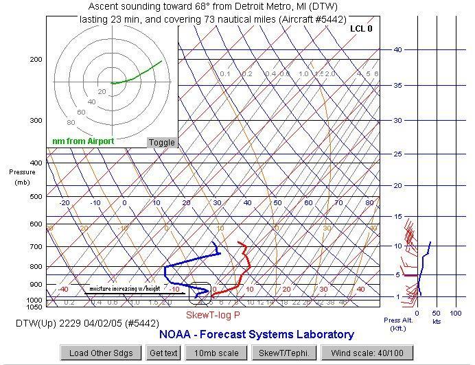
10
11 Ceilings and Visibilities Forecasters at DTX amended their TAF for the 09 to 12 UTC period, reducing visibilities to ½ mile. The METARS below show that it became even foggier than that. Kdtw 0532z 00000kt 2sm br clr Kdtw 0739z 17003kt 1 3/4sm br r04/1000v3500 Kdtw 0936z 17004kt 1/4sm fg r04/0500v0600 Kdtw 1154z 16004kt 1/4sm fg r04/2800v0600 Aircraft observations are increasingly being used to forecast the development of low clouds and fog.
12 Icing and Turbulence The U.S. Air Force Weather Agency used TAMDAR to verify an icing forecast from their MM5 model.

13 Icing and Turbulence Icing is forecast for the middle Atlantic States, Ohio Valley and Lower Michigan
14 Icing and Turbulence Is Icing occurring here in Michigan? Icing PIREPS for all levels UTC

15 Icing and Turbulence Yes! Icing near TVC and PLN Automated aircraft reports of icing and turbulence will help AFWA And the AWC in the forecast and verification of these aviation hazards.
16 Winter Storms Precipitation type forecasts can be made with greater accuracy with AMDAR. Frequent soundings show the height of the freezing level, and the presence of elevated warm layers, both of which are necessary for accurate precipitation type forecasts.
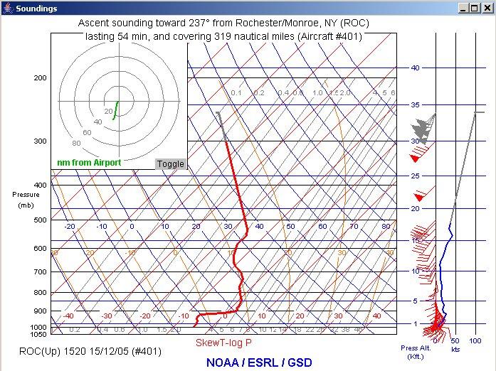
17 Precipitation Type Forecasts The Storm Prediction Center used ACARS data for a freezing rain event across eastern New York and southern New England on December 8, Their discussion issued in the early afternoon mentioned ACARS soundings from the vicinity of Boston that showed an elevated warm layer. SPC MESOSCALE DISCUSSION #1100 FOR FREEZING RAIN... AREAS OF FREEZING RAIN ARE LIKELY ACROSS PARTS OF EAST CENTRAL NEW YORK...SRN NH AND SRN VT. FREEZING RAIN IS EXPECTED TO ACCUMULATE ON EXPOSED SURFACES THROUGH 08/23Z. LATEST SATELLITE PICTURES INDICATE CLOUD TOPS HAVE COOLED OVER ERN NY...SRN NH...AND SRN VT IN THE PAST HOUR. ACARS SOUNDINGS FROM BOS SHOW 850MB TEMPERATURE OF 4C WHILE SURFACE TEMPERATURES REMAIN NEAR FREEZING...
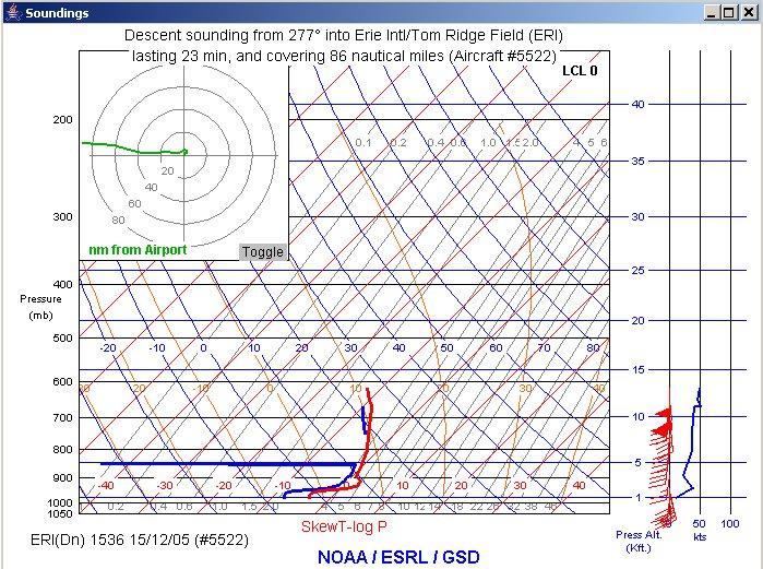
18 Precipitation Type Forecasts On December 15, 2005 meteorologists at the NWS office in Buffalo, N.Y. used AMDAR soundings to determine that there was a substantial warm layer between 2,000 and 5,000 feet above the ground. Because there was such a deep layer of warm air, the forecast was updated to reduce snow accumulations and increase the amount of sleet and freezing rain.
19
20
21 Convective Forecasts AMDAR data have been used extensively in support of convective forecasts. Temperature and moisture data provide the needed information to determine the stability of the atmosphere. Wind data can be used to construct hodographs.

22 A Convective non-event A linear mesoscale convective system was over eastern Minnesota and western Wisconsin at 1500 UTC on June 7, 2005.

23 A Convective non-event It was thought initially that this elevated convection would become surface based as the system moved east during the day. A Severe Thunderstorm Watch was issued for much of Wisconsin at 1530 UTC.
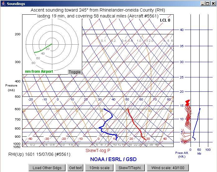
24 A Convective non-event Shortly after the issuance of the watch, forecasters at the Green Bay NWS noticed that TAMDAR soundings from the watch area appeared much too stable for surface based convection. A sounding from the Central Wisconsin airport at 1512 UTC showed a strong capping inversion, that was unlikely to break. Another sounding at 1923 UTC showed the atmosphere was still much too stable for convection. Forecasters then lowered the chance for thunderstorms, and the watch was later dropped.


25 A Convective non-event 1512 UTC Sounding 1923 UTC Sounding
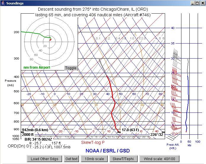
26 A Convective non-event The thunderstorms that prompted the severe thunderstorm watch never became surface based as they moved east. Meteorologists had been tricked by forecast soundings that predicted the cap to erode sufficiently for surface based storms to form. This problem became less frequent as more forecasters used AMDAR data.
 was much less stable than TAMDAR")
27 A Convective non-event RUC Forecast (black) was much less stable than TAMDAR sounding
28 Fire Weather Accurate fire weather forecasts require knowledge of stability, wind and moisture availability above the ground. The large spatial and temporal gaps in radiosonde data make this difficult. Places distant from radiosondes are at an even large disadvantage. AMDAR data can fill many of these gaps, and is now used increasingly in fire weather forecasts.
29 Fire Weather Forecasters found AMDAR data useful in deciding to expand a *Red Flag Warning in effect for Northern and Central Wisconsin on the afternoon of July 15, Very dry air could be seen on TAMDAR soundings earlier in the day when the Red Flag Warning was issued. Later soundings showed there was sufficient dry air in other parts of the forecast area to expand the warning. * Temperature >75F, RH <25%, winds of 25 mph
30 Fire Weather AREA FORECAST DISCUSSION...UPDATED NWS GREEN BAY WI 200 PM CDT SAT JUL UPDATED...ADDED AREAL COVERAGE FOR THE RED FLAG HEADLINES. RH/S ALREADY IN THE 20 PCTS EARLY THIS AFTERNOON AND WINDS NEAR CRITERIA OVER NW WI. TAMDAR SOUNDING THIS AM FROM RHI SHOWS A VERY DRY AIR MASS TO MIX DOWN WITH NEAR CRITIERIA WINDS.
31
32 Marine Applications Surface wind and resulting waves are influenced greatly by both winds aloft and stability. Unstable air helps mix down strong winds above the boundary layer, while stable conditions hinder mixing. AMDAR are ideal for determining both winds aloft and atmospheric stability.
33 Marine Applications AMDAR has been used in the Great Lakes region and along the shorelines of the United States in marine forecasts. The following is an example from October 3, The NWS in Chicago used AMDAR data to determine that the atmosphere was sufficiently unstable to mix down 35 knot winds to the surface. Based on this information, they wisely decided to continue the Gale Warning that had been issued earlier in the day.
34 Marine Applications AREA FORECAST DISCUSSION NATIONAL WEATHER SERVICE CHICAGO IL 715 PM CDT SUN OCT MARINE...SHIP REPORTS OF GALES THIS EVENING FROM THE SOUTHWEST. SURFACE ANALYSIS AND USING THE ACARS SOUNDING FROM ORD AT 2230 UTC SHOW STRONG WINDS ALOFT AND BEHIND THE FRONT. WILL KEEP THE GALE WARNING FOR OVERNIGHT. WHW
35
36 Hazardous Materials Support AMDAR is used frequently by the National Transportation Safety Board in the investigation of aviation and marine accidents. AMDAR data was used in support of the September 11 th disaster. AMDAR can be input into local models to predict the drift of hazardous materials.
37 Questions? Richard Mamrosh National Weather Service 2485 South Point Road Green Bay, WI USA (920)
4.3 AVIATION APPLICATIONS OF TAMDAR AIRCRAFT DATA REPORTS
 4.3 AVIATION APPLICATIONS OF TAMDAR AIRCRAFT DATA REPORTS Richard D. Mamrosh NWS Green Bay, WI Taumi S. Daniels NASA Langley, Hampton, VA William R. Moninger Earth System Research Laboratory, Boulder,
1st Annual Southwest Ohio Snow Conference April 8, 2010 Abner F. Johnson, Office of Maintenance - RWIS Coordinator
 1st Annual Southwest Ohio Snow Conference April 8, 2010 Abner F. Johnson, Office of Maintenance - RWIS Coordinator The Ohio Department of Transportation ODOT has approximately 5500 full-time employees
The enduring fog and low cloud episode of 5-10 December 2015: Big Bubble Fog Trouble
 1. Overview The enduring fog and low cloud episode of 5-10 December 2015: Big Bubble Fog Trouble By Richard H. Grumm National Weather Service State College, PA An enduring low cloud and fog episode affected
STUDY UNIT SEVENTEEN GRAPHICAL AIRMAN S METEOROLOGICAL ADVISORY (G-AIRMET)
") STUDY UNIT SEVENTEEN GRAPHICAL AIRMAN S METEOROLOGICAL ADVISORY (G-AIRMET) 341 (10 pages of outline) 17.1 Product Description....................................................... 341 17.2 Issuance...............................................................
STUDY UNIT SEVENTEEN GRAPHICAL AIRMAN S METEOROLOGICAL ADVISORY (G-AIRMET) 341 (10 pages of outline) 17.1 Product Description....................................................... 341 17.2 Issuance...............................................................
8.2 EVALUATING THE BENEFITS OF TAMDAR DATA IN CONVECTIVE FORECASTING. Cyrena-Marie Druse 1 AirDat LLC. Evergreen, CO
 8.2 EVALUATING THE BENEFITS OF TAMDAR DATA IN CONVECTIVE FORECASTING Cyrena-Marie Druse 1 AirDat LLC. Evergreen, CO 1. INTRODUCTION 1 The TAMDAR (Tropospheric Airborne Meteorological Data Reporting) Sensor
National Transportation Safety Board Office of Aviation Safety Washington, D.C December 10, 2012 WEATHER STUDY DCA13RA025
 A. ACCIDENT National Transportation Safety Board Office of Aviation Safety Washington, D.C. 20594-2000 December 10, 2012 WEATHER STUDY DCA13RA025 Location: Monterrey, Mexico Date: December 9, 2012 Time:
Summary of November Central U.S. Winter Storm By Christopher Hedge
 Summary of November 12-13 2010 Central U.S. Winter Storm By Christopher Hedge Event Overview The first significant snowfall of the 2010-2011 season affected portions of the plains and upper Mississippi
9.4 APPLICATIONS OF TAMDAR AIRCRAFT DATA REPORTS IN NWS FORECAST OFFICES
 9.4 APPLICATIONS OF TAMDAR AIRCRAFT DATA REPORTS IN NWS FORECAST OFFICES 1 Richard D. Mamrosh, 1 Eugene S. Brusky, 1 Jeffrey K. Last, 2,3 Ed Szoke, 2 William R. Moninger, 4 Taumi S. Daniels 1 National
Wind Events. Flooding Events. T-Storm Events. Awareness Alerts / Potential Alerts / Action Alerts / Immediate Action Alerts / Emergency Alerts.
 Information Updated: February of 2016 Our Alert Terms Definitions * Use exactly as seen below * Wind Events Awareness Alert - Strong Winds Potential Alert - Damaging Winds ACTION Alert - Damaging Winds
Aircraft-based Observations: Impact on weather forecast model performance
 Aircraft-based Observations: Impact on weather forecast model performance Stephen S. Weygandt Eric James, Stan Benjamin, Bill Moninger, Brian Jamison, Geoff Manikin* NOAA Earth System Research Laboratory
9.5 EVALUATING THE BENEFITS OF TAMDAR DATA IN AVIATION FORECASTING. Cyrena-Marie Druse 1 and Neil Jacobs AirDat LLC. Evergreen, CO
 9.5 EVALUATING THE BENEFITS OF TAMDAR DATA IN AVIATION FORECASTING Cyrena-Marie Druse 1 and Neil Jacobs AirDat LLC. Evergreen, CO 1. INTRODUCTION 1 The TAMDAR (Tropospheric Airborne Meteorological Data
Severe Weather Watches, Advisories & Warnings
 Severe Weather Watches, Advisories & Warnings Tornado Watch Issued by the Storm Prediction Center when conditions are favorable for the development of severe thunderstorms and tornadoes over a larger-scale
MET Lecture 34 Downbursts
 MET 4300 Lecture 34 Downbursts Downbursts A strong downdraft that originates within the lower part of a cumulus cloud or thunderstorms and spreads out at the surface Downbursts do not require strong thunderstorms
2.2 APPLICATIONS OF AIRCRAFT SOUNDING DATA IN SHORT-TERM CONVECTIVE FORECASTING
 2.2 APPLICATIONS OF AIRCRAFT SOUNDING DATA IN SHORT-TERM CONVECTIVE FORECASTING Phillip G. Kurimski* and Eugene S. Brusky Jr. NOAA/National Weather Service, Green Bay, WI 1. INTRODUCTION Automated real-time
WEATHER FORECASTING Acquisition of Weather Information WFO Regions Weather Forecasting Tools Weather Forecasting Tools Weather Forecasting Methods
 1 2 3 4 5 6 7 8 WEATHER FORECASTING Chapter 13 Acquisition of Weather Information 10,000 land-based stations, hundreds of ships and buoys; four times a day, airports hourly Upper level: radiosonde, aircraft,
Snow Measurement Guidelines for National Weather Service Snow Spotters
 Snow Measurement Guidelines for National Weather Service Snow Spotters National Weather Service Forecast Office Northern Indiana October 2004 Table of Contents Introduction 3 Definitions.. 3 Relaying Real
Pilots watch the clouds, because clouds can indicate the kind of weather in store for a flight.
 Low stratus Cumulonimbus Pilots watch the clouds, because clouds can indicate the kind of weather in store for a flight. FILL IN THE BLANKS OR CIRCLE ONE: A. Stratus means flat or on one level. Low stratus
DEPARTMENT OF EARTH & CLIMATE SCIENCES SAN FRANCISCO STATE UNIVERSITY. Metr Fall 2014 Test #1 September 30, 2014
 DEPARTMENT OF EARTH & CLIMATE SCIENCES SAN FRANCISCO STATE UNIVERSITY NAME Metr 302.02 Fall 2014 Test #1 September 30, 2014 200 pts (4 pts each answer) Part I. Surface Chart Interpretation. Questions 1
Winter Weather. National Weather Service Buffalo, NY
 Winter Weather National Weather Service Buffalo, NY Average Seasonal Snowfall SNOWFALL = BIG IMPACTS School / government / business closures Airport shutdowns/delays Traffic accidents with injuries/fatalities
Issued by: National Weather Service San Joaquin Valley - Hanford CA. Issue time: 409 AM PST Wed Jan
 Forecast Information Location: New_Exchequer_Dam Updated: January 16, 2019, 11:45 am NWS Weather Discussion: Issued by: National Weather Service San Joaquin Valley - Hanford CA Issue time: 409 AM PST Wed
Elements of the National Weather Service Fire Weather Forecast By Casey Sullivan, National Weather Service, Chicago
 Elements of the National Weather Service Fire Weather Forecast By Casey Sullivan, National Weather Service, Chicago Today s Presentation Begins at 12 pm CST, 1 pm EST Please Take Our One Question Survey
SPEARFISH FIRE DEPARTMENT POLICIES AND PROCEDURES
 SPEARFISH FIRE DEPARTMENT POLICIES AND PROCEDURES Page 1 of 5 Volume: Operation Section: 20.00 Number: 20.09 Subject: Weather Watches, Warnings, Advisory s and Spotter Activation Date Issued: 28 March
IWT Scenario 2 Integrated Warning Team Workshop National Weather Service Albany, NY October 31, 2014
 IWT Scenario 2 Integrated Warning Team Workshop National Weather Service Albany, NY October 31, 2014 09 10 11 12 13 Scenario 2 Timeline December 9-13 Tue Wed Thu Fri Sat Tue, Dec. 9 @ 5 am 2014 2014 2014
Weather - is the state of the atmosphere at a specific time & place
 Weather Section 1 Weather - is the state of the atmosphere at a specific time & place Includes such conditions as air pressure, wind, temperature, and moisture in the air The Sun s heat evaporates water
IWT Scenario 1 Integrated Warning Team Workshop National Weather Service Albany, NY October 31, 2014
 Integrated Warning Team Workshop National Weather Service Albany, NY October 31, 2014 23 24 25 26 27 Scenario 1 Timeline November 23-27 Sun Mon Tue Wed Thu Thanksgiving Day Sunday, Nov. 23 @ 430 pm NWS
DETERMINING USEFUL FORECASTING PARAMETERS FOR LAKE-EFFECT SNOW EVENTS ON THE WEST SIDE OF LAKE MICHIGAN
 DETERMINING USEFUL FORECASTING PARAMETERS FOR LAKE-EFFECT SNOW EVENTS ON THE WEST SIDE OF LAKE MICHIGAN Bradley M. Hegyi National Weather Center Research Experiences for Undergraduates University of Oklahoma,
Moisture, Clouds, and Precipitation: Clouds and Precipitation. Dr. Michael J Passow
 Moisture, Clouds, and Precipitation: Clouds and Precipitation Dr. Michael J Passow What Processes Lift Air? Clouds require three things: water vapor, a condensation nucleus, and cooling Cooling usually
Low-end derecho of 19 August 2017
 Low-end derecho of 19 August 2017 By Richard H. Grumm and Charles Ross National Weather Service State College, PA 1. Overview A cluster of thunderstorms developed in eastern Ohio around 1800 UTC on 19
777 Neptune Groundschool Weather reporting & forecasts
 777 Neptune Groundschool 2018 Weather reporting & forecasts Weather Reporting Weather Forecast is a prediction of what the weather conditions will be in the future Weather Report tells the reader of what
SPC Mission Statement. Tornado in Miami, FL Photo: Miami Herald. What is SPC s Responsibility? More SPC Products. SPC Products
 The NOAA/NWS Storm Prediction Center Adapted from a presentation to UNCA atmospheric science students by David Imy SPC Mission Statement SPC exists to protect life and property of the American people through
July 24, 2017 Annapolis, MD Bryan A. Jackson NWS Sterling, VA Marine Program Leader
 When Wicked Weather Strikes Insights into Chesapeake Bay Weather July 24, 2017 Annapolis, MD Bryan A. Jackson NWS Sterling, VA Marine Program Leader Mission of the National Weather Service Provide climate,
Preparing For Winter Weather At Home & In The Workplace. Brandon Peloquin, Warning Coordination Meteorologist NWS Wilmington OH
 Preparing For Winter Weather At Home & In The Workplace Brandon Peloquin, Warning Coordination Meteorologist NWS Wilmington OH What We Will Talk About Introduction to the National Weather Service How we
DEPARTMENT OF GEOSCIENCES SAN FRANCISCO STATE UNIVERSITY. Metr Fall 2012 Test #1 200 pts. Part I. Surface Chart Interpretation.
 DEPARTMENT OF GEOSCIENCES SAN FRANCISCO STATE UNIVERSITY NAME Metr 356.01 Fall 2012 Test #1 200 pts Part I. Surface Chart Interpretation. Figure 1. Surface Chart for 1500Z 7 September 2007 1 1. Pressure
Ch. 3: Weather Patterns. Sect. 1: Air Mass & Fronts Sect. 2: Storms Sect. 3: Predicting the Weather
 Ch. 3: Weather Patterns Sect. 1: Air Mass & Fronts Sect. 2: Storms Sect. 3: Predicting the Weather Sect. 1: Air Masses & Fronts An air mass is a huge body of air that has similar temperature, humidity,
Science Olympiad Meteorology Quiz #2 Page 1 of 8
 1) The prevailing general direction of the jet stream is from west to east in the northern hemisphere: 2) Advection is the vertical movement of an air mass from one location to another: 3) Thunderstorms
TFS WEATHER BRIEF. Monday, March 25
 TFS WEATHER BRIEF Monday, March 25 Review: The leading edge of cooler and drier air was pushing through Central and East TX this morning. A few lingering thunderstorms were in progress south of I-20 in
Weather vs. Climate. Tucson NWS homepage:
 Weather vs. Climate Tucson NWS homepage: www.nws.noaa.gov/twc/ A Weather Forecaster? Betty claims to know exactly when it s going to rain because her knee starts to hurt. Ms. Betty Martin of Newburgh,
Unit 5 Lesson 3 How is Weather Predicted? Copyright Houghton Mifflin Harcourt Publishing Company
 Tracking the Weather Warm up 1 Why is it important to watch the weather forecast before traveling to another country? Tracking the Weather A meteorologist is a scientist who studies weather. Meteorologists
Implementation Guidance of Aeronautical Meteorological Observer Competency Standards
 Implementation Guidance of Aeronautical Meteorological Observer Competency Standards The following guidance is supplementary to the AMP competency Standards endorsed by Cg-16 in Geneva in May 2011. Please
Weather Basics. Challenges of Winter Weather Forecasting Along the East Coast North American Snow Conference 5/23/16
 Challenges of Winter Weather Forecasting Along the East Coast Sara Croke sara@weatherornot.com Sullivan Brown sully@weatherornot.com @WeatherorNotInc /WeatherOrNotInc 913.722.3955 Weather Basics Moisture
Coastal Storm. Wednesday through Friday, 3/6-8/2013 Weather Briefing
 Coastal Storm Wednesday through Friday, 3/6-8/2013 Weather Briefing Prepared 2:00 PM EST Wednesday, March 6, 2013 National Weather Service New York, NY Purpose of Briefing Promote Situational Awareness
Custom Weather Forecast
 1 of 23 Custom Weather Forecast 2018 Chicago Yacht Club s Race To Mackinac- Cruising Division Disclaimer: The user assumes all risk related to the use of this Custom Weather Forecast. The crew of the participating
Advances in Weather Technology
 Advances in Weather Technology Dr. G. Brant Foote National Center for Atmospheric Research 16 May 2001 NCAR Research Results in Aviation Weather Built on the foundation of the nation s long-standing investment
Winter Storm Tomorrow-Tomorrow Night
 Winter Storm Tomorrow-Tomorrow Night Decision Support Briefing #1 As of 4:30 PM Tuesday, February 19, 2019 What Has Changed? Initial Briefing Main Points Hazard Impacts Location Timing Snow Snow will create
Weather, Air Masses, Fronts and Global Wind Patterns. Meteorology
 Weather, Air Masses, Fronts and Global Wind Patterns Meteorology Weather is what conditions of the atmosphere are over a short period of time. Climate is how the atmosphere "behaves" over long periods
Plan for operational nowcasting system implementation in Pulkovo airport (St. Petersburg, Russia)
") Plan for operational nowcasting system implementation in Pulkovo airport (St. Petersburg, Russia) Pulkovo airport (St. Petersburg, Russia) is one of the biggest airports in the Russian Federation (150
Plan for operational nowcasting system implementation in Pulkovo airport (St. Petersburg, Russia) Pulkovo airport (St. Petersburg, Russia) is one of the biggest airports in the Russian Federation (150
Storm Summary for Hurricane Jose
 Storm Summary for Hurricane Jose Tuesday, September 19, 2017 at 11 AM EDT (Output from Hurrevac, based on National Hurricane Center Forecast Advisory #57) Jose is currently a Category 1 hurricane on the
Michael F. Stringfellow
 Michael F. Stringfellow Thermals Columns or bubbles of warm air that rise from the ground when it is heated by the sun Soaring Sustained engineless flight using natural sources of lift Boundary or mixing
Foundations of Earth Science, 6e Lutgens, Tarbuck, & Tasa
 Foundations of Earth Science, 6e Lutgens, Tarbuck, & Tasa Weather Patterns and Severe Weather Foundations, 6e - Chapter 14 Stan Hatfield Southwestern Illinois College Air masses Characteristics Large body
1. INTRODUCTION * Figure 1. National Weather Service Storm Prediction Center (SPC) storm reports for December 1, 2006.
 storm reports for December 1, 2006.") P1.14 FORECAST ISSUES RELATED TO THE UNPRECEDENTED SEVERE AND HIGH WIND EVENT OF DECEMBER 2006 by Greg A. DeVoir* and Richard H. Grumm National Weather Service Office State College, PA 16803 1. INTRODUCTION
P1.14 FORECAST ISSUES RELATED TO THE UNPRECEDENTED SEVERE AND HIGH WIND EVENT OF DECEMBER 2006 by Greg A. DeVoir* and Richard H. Grumm National Weather Service Office State College, PA 16803 1. INTRODUCTION
A Complex Weather System: Tuesday Afternoon into Thursday March 3 5, 2015
 A Complex Weather System: Tuesday Afternoon into Thursday March 3 5, 2015 Briefing #1, prepared 900 AM EST Tuesday, March 3, 2015 by Meteorologists at NWS - WFO Mount Holly, NJ To promote situational awareness
WMO AMDAR Programme Overview
 WMO AMDAR Programme Overview Bryce Ford - presenting on behalf of WMO and NOAA FPAW Nov 1, 2012 The WMO AMDAR Program AMDAR Programme Current Status WMO World Meteorological Organization (http://www.wmo.int)
Winter Storm Update. Through Late Afternoon: Jacksonville, FL Weather Forecast Office. Northeast Florida and Southeast Georgia
 Winter Storm Update Through Late Afternoon: Winter Storm Warning for all of Southeast GA and portions of Suwannee Valley and I-10 Corridor west of Jacksonville. Dangerous ice storm expected from Live Oak
Weather Briefing Mixed Winter Storm Event February 26-27, 2013
 Weather Briefing Mixed Winter Storm Event February 26-27, 2013 Prepared 1200 PM EST Tuesday, February 26th, 2013 Joe Miketta NOAA s NJ Forecast Office http://www.erh.noaa.gov/phi/ Purpose of Briefing Briefing
Fronts. Direction of Front
 Fronts Direction of Front Direction of Front Warm Front A cold air mass meets and displaces a warm air mass. Because the moving cold air is more dense, it moves under the less-dense warm air, pushing it
Air Masses, Fronts & Storms
 Air Masses, Fronts & Storms Air Masses and Fronts Bell Work Define Terms (page 130-135) Vocab Word Definition Picture Air Mass A huge body of air that has smilier temperature, humidity and air pressure
Coastal Storm this Weekend
 Weather Briefing Prepared 9 AM EST Feb 5, 2010 Joe Miketta Warning Coordination Meteorologist NOAA s National Weather Service Philadelphia/Mt. Holly NJ Forecast Office 609-261 261-6602 6602 x223 Joseph.Miketta@noaa.gov
III. Section 3.3 Vertical air motion can cause severe storms
 III. Section 3.3 Vertical air motion can cause severe storms http://www.youtube.com/watch?v=nxwbr60tflg&feature=relmfu A. Thunderstorms form from rising moist air Electrical charges build up near the tops
Condensation: Dew, Fog, & Clouds. Chapter 5
 Condensation: Dew, Fog, & Clouds Chapter 5 The Formation of Dew & Frost Dew forms on objects near the ground surface when they cool below the dew point temperature. More likely on clear nights due to increased
Deliverable 4-2: Assessment items. Activity-oriented Quiz for Weather or Not? Investigation in Exploring the Environment
 Deliverable 4-2: Assessment items Activity-oriented Quiz for Weather or Not? Investigation in Exploring the Environment In Weather or Not? you predicted the weather using satellite images and other kinds
W I N T E R STORM HAZARD DESCRIPTION
 W I N T E R STORM HAZARD DESCRIPTION... 1 LOCATION... 2 EXTENT... 2 HISTORICAL OCCURRENCES... 4 SIGNIFICANT PAST EVENTS... 4 PROBABILITY OF FUTURE EVENTS... 5 VULNERABILITY AND IMPACT... 5 HAZARD DESCRIPTION
Weather and the Atmosphere. RAP Short Course
 Weather and the Atmosphere RAP Short Course Syllabus 1) Vertical structure and composition of the atmosphere, basic weather variables 2) Warming Earth and its atmosphere the diurnal and seasonal cycles
FAA Weather Research Plans
 FAA Weather Research Plans Presented to: Friends /Partners in Aviation Weather Vision Forum By: Ray Moy FAA Aviation Weather Office Date: Aviation Weather Research Program (AWRP) Purpose: Applied Research
What is Storm Anticipation (SA)? Using the SPC mesoanalysis fields to anticipate what is likely to occur.
? Using the SPC mesoanalysis fields to anticipate what is likely to occur.") Fisher 2018 What is Storm Anticipation (SA)? Using the SPC mesoanalysis fields to anticipate what is likely to occur. Why do I need it? I have read the SPC outlooks and discussions (part of SA) I have
Fisher 2018 What is Storm Anticipation (SA)? Using the SPC mesoanalysis fields to anticipate what is likely to occur. Why do I need it? I have read the SPC outlooks and discussions (part of SA) I have
A Description of Convective Weather Containing Ice Crystals Associated with Engine Powerloss and Damage
 A Description of Convective Weather Containing Ice Crystals Associated with Engine Powerloss and Damage The Boeing Company 1 Photo: courtesy of Ian McPherson The Boeing Company acknowledges the contributions
Safety At Sea Seminar April 12, Basic Marine Weather Forecasting
 1 of 79 Safety At Sea Seminar April 12, 2014 Basic Marine Weather Forecasting Mark A. Thornton LakeErieWX: Marine Weather Education and Forecasting Resources Email: LakeErieWX@gmail.com 2 of 79 3 of 79
Anthony A. Rockwood Robert A. Maddox
 Anthony A. Rockwood Robert A. Maddox An unusually intense MCS produced large hail and wind damage in northeast Kansas and northern Missouri during the predawn hours of June 7 th, 1982. Takes a look at
The International AMDAR Program
 Aircraft Meteorological DAta Relay The International AMDAR Program Improving Weather Forecasts With AMDAR data are used operationally to support a wide range of meteorological applications and are considered
Weather Briefing for Pennsylvania Feb Outlook Prepared 02/11/14 2 pm EST
 Weather Briefing for Pennsylvania Feb. 12-13 Outlook Prepared 02/11/14 2 pm EST Prepared by: National Weather Service State College, PA (Peter.Jung@noaa.gov) Pennsylvania Weather Overview A significant
Weather: Air Patterns
 Weather: Air Patterns Weather: Air Patterns Weather results from global patterns in the atmosphere interacting with local conditions. You have probably experienced seasonal shifts, such as winter in New
MULTI-AGENCY COORDINATION SYSTEM PUBLICATION CALIFORNIA FIRE WEATHER PROGRAM RISK PREPAREDNESS GUIDE MACS 410-3
 MULTI-AGENCY COORDINATION SYSTEM PUBLICATION CALIFORNIA FIRE WEATHER PROGRAM RISK PREPAREDNESS GUIDE MACS 410-3 August 26, 2013 California Fire Weather Program Risk Preparedness Guide Table of Contents
Chapter 14 Thunderstorm Fundamentals
 Chapter overview: Thunderstorm appearance Thunderstorm cells and evolution Thunderstorm types and organization o Single cell thunderstorms o Multicell thunderstorms o Orographic thunderstorms o Severe
Answer Key. Page 1 of 5
 Answer Key Name: Score: [1] When telephoning a weather briefing facility for preflight weather information, pilots should state A. whether they intend to fly VFR only. B. the full name and address of the
STATION If relative humidity is 60% and saturation vapor pressure is 35 mb, what is the actual vapor pressure?
 STATION 1 Vapor pressure is a measure of relative humidity and saturation vapor pressure. Using this information and the information given in the problem, answer the following question. 1. If relative
The Severe Weather Event of 7 August 2013 By Richard H. Grumm and Bruce Budd National Weather Service State College, PA 1. INTRODUCTION and Overview
 The Severe Weather Event of 7 August 2013 By Richard H. Grumm and Bruce Budd National Weather Service State College, PA 1. INTRODUCTION and Overview A fast moving short-wave (Fig. 1) with -1σ 500 hpa height
Lecture #14 March 29, 2010, Monday. Air Masses & Fronts
 Lecture #14 March 29, 2010, Monday Air Masses & Fronts General definitions air masses source regions fronts Air masses formation types Fronts formation types Air Masses General Definitions a large body
Chapter Introduction. Weather. Patterns. Forecasts Chapter Wrap-Up
 Chapter Introduction Lesson 1 Lesson 2 Lesson 3 Describing Weather Weather Patterns Weather Forecasts Chapter Wrap-Up How do scientists describe and predict weather? What do you think? Before you begin,
Marine Corps Installations East Regional METOC Center MCAS Cherry Point, NC Standardized Weather Warnings Definitions
 Marine Corps Installations East Regional METOC Center MCAS Cherry Point, NC Standardized Weather Warnings Definitions Updated: 25 June 2012 MCIE Standardized Weather Warnings Warning Local Wind Warning
Tuesday, September 13, 16
 Weather Weather State Objectives 4.c, 4.d, 4.h. Discussion What are some ways in which weather affects your everyday life? Discussion What are some ways in which weather affects your everyday life? What
Building a Weather-Ready Wisconsin
 National Weather Service Session: Building a Weather-Ready Wisconsin WEMA Conference October 11, 2017 Jeff Last National Weather Service Green Bay Today s Presentation NWSChat in EM Operations The June
Traffic and Weather. Soaring Safety Foundation. Tom Johnson CFIG
 Traffic and Weather Soaring Safety Foundation Tom Johnson CFIG Weather Contents Weather Gathering Sources Weather Acquisition Enroute Weather Analysis Weather Hazards Weather in the Landing Pattern Basic
Air Masses, Fronts, Storm Systems, and the Jet Stream
 Air Masses, Fronts, Storm Systems, and the Jet Stream Air Masses When a large bubble of air remains over a specific area of Earth long enough to take on the temperature and humidity characteristics of
A summary of the heat episodes of June 2017
 A summary of the heat episodes of June 2017 By Richard H. Grumm and Elissa A. Smith National Weather Service State College, PA 1. Overview Over 1800 record high temperatures were set or tied during the
Fort Lewis, Washington (47 05'N, 'W)
") Fort Lewis, Washington (47 05'N, 122 35'W) Full Year Climatology CONVENTIONS: The spelling of place names and geographical features are those used by the National Imagery and Mapping Agency (NIMA). All
Fort Lewis, Washington (47 05'N, 122 35'W) Full Year Climatology CONVENTIONS: The spelling of place names and geographical features are those used by the National Imagery and Mapping Agency (NIMA). All
The Pennsylvania Observer
 The Pennsylvania Observer January 5, 2009 December 2008 Pennsylvania Weather Recap The final month of 2008 was much wetter than average and a bit colder than normal. In spite of this combination, most
National Maritime Center
 National Maritime Center Providing Credentials to Mariners (Sample Examination) Page 1 of 5 Choose the best answer to the following Multiple Choice Questions. 1. Fog is formed when which condition exists?
1. Which weather map symbol is associated with extremely low air pressure? A) B) C) D) 2. The diagram below represents a weather instrument.
 B) C) D) 2. The diagram below represents a weather instrument.") 1. Which weather map symbol is associated with extremely low air pressure? 2. The diagram below represents a weather instrument. Which weather variable was this instrument designed to measure? A) air pressure
1. Which weather map symbol is associated with extremely low air pressure? 2. The diagram below represents a weather instrument. Which weather variable was this instrument designed to measure? A) air pressure
Weather report 28 November 2017 Campinas/SP
 Weather report 28 November 2017 Campinas/SP Summary: 1) Synoptic analysis and pre-convective environment 2) Verification 1) Synoptic analysis and pre-convective environment: At 1200 UTC 28 November 2017
Western States Water Council Forecasting Weather Data June 24, 2014
 Western States Water Council Forecasting Weather Data June 24, 2014 Roger V. Pierce Meteorologist -in- Charge NOAA / National Weather Service San Diego CA Mission- to provide forecasts and warnings: The
Updated 12 Sep 2002 Talking Points for VISITview Lesson Fog Detection and Analysis With Satellite Data Gary Ellrod (NOAA/NESDIS) 1.
 1.") Updated 12 Sep 2002 Talking Points for VISITview Lesson Fog Detection and Analysis With Satellite Data Gary Ellrod (NOAA/NESDIS) 1. Title 2. Fog has a major impact on air safety and efficiency, and may
Updated 12 Sep 2002 Talking Points for VISITview Lesson Fog Detection and Analysis With Satellite Data Gary Ellrod (NOAA/NESDIS) 1. Title 2. Fog has a major impact on air safety and efficiency, and may
Daily Operations Briefing Monday, January 26, :30 a.m. EST
 Daily Operations Briefing Monday, January 26, 2015 8:30 a.m. EST Significant Activity: Jan 25-26 Significant Events: Severe Winter Weather Mid-Atlantic to Northeast Significant Weather: Heavy Snow Mid-Atlantic
HAZARD DESCRIPTION... 1 LOCATION... 1 EXTENT... 1 HISTORICAL OCCURRENCES...
 WINTER STORM HAZARD DESCRIPTION... 1 LOCATION... 1 EXTENT... 1 HISTORICAL OCCURRENCES... 3 SIGNIFICANT PAST EVENTS... 4 PROBABILITY OF FUTURE EVENTS... 5 VULNERABILITY AND IMPACT... 5 Hazard Description
Major Winter Storm to impact Western Washington. 17 January 2012 National Weather Service Seattle/Tacoma
 Major Winter Storm to impact Western Washington 17 January 2012 National Weather Service Seattle/Tacoma Current Warnings Winter Storm Warning for all of Western Washington, except: Northwest interior Extreme
DEPARTMENT OF EARTH & CLIMATE SCIENCES Name SAN FRANCISCO STATE UNIVERSITY Nov 29, ERTH 360 Test #2 200 pts
 DEPARTMENT OF EARTH & CLIMATE SCIENCES Name SAN FRANCISCO STATE UNIVERSITY Nov 29, 2018 ERTH 360 Test #2 200 pts Each question is worth 4 points. Indicate your BEST CHOICE for each question on the Scantron
Daily Operations Briefing Saturday, October 1, :30 a.m. EDT
 Daily Operations Briefing Saturday, October 1, 2016 8:30 a.m. EDT Significant Activity Sept 30-Oct 1 Significant Events: None Tropical Activity: Atlantic Hurricane Matthew (CAT4); Disturbance 1 Low (10%)
Daily Operations Briefing Monday, December 26, :30 a.m. EST
 Daily Operations Briefing Monday, December 26, 2016 8:30 a.m. EST Significant Activity Dec 25-26 Significant Events: None Significant Weather: Heavy Snow Pacific Northwest, Northern Intermountain and the
Answers to Clicker Questions
 Answers to Clicker Questions Chapter 1 What component of the atmosphere is most important to weather? A. Nitrogen B. Oxygen C. Carbon dioxide D. Ozone E. Water What location would have the lowest surface
METEOROLOGY. 1 The average height of the tropopause at 50 N is about A 14 km B 16 km C 11 km D 8 km
 1 The average height of the tropopause at 50 N is about A 14 km B 16 km C 11 km D 8 km 2 In the lower part of the stratosphere the temperature A is almost constant B decreases with altitude C increases
Thundersnow. flightops. Difficult to forecast and rare, but a real threat to landing or low-altitude aircraft. By Ed Brotak
 Thundersnow Difficult to forecast and rare, but a real threat to landing or low-altitude aircraft. By Ed Brotak 18 flight safety foundation AeroSafetyWorld October 2010 flightops Mike Tigas/Flickr It was
Understanding Michigan snowfall. Jim Keysor - NWS Gaylord
 Understanding Michigan snowfall Jim Keysor - NWS Gaylord Presentation Outline Topics Background information on lake effect Radar and lake effect snow Wind direction and lake effect Lake Enhanced snow Elevation