The next generation in weather radar software.
|
|
|
- Byron Jacob Ramsey
- 5 years ago
- Views:
Transcription


1 The next generation in weather radar software.
2 PUBLISHED BY Vaisala Oyj Phone (int.): P.O. Box 26 Fax: FI Helsinki Finland Try IRIS Focus at iris.vaisala.com. Vaisala 2017 This material is subject to copyright protection, with all copyrights retained by Vaisala and its individual partners. All rights reserved. The reproduction, transfer, distribution or storage of information contained in this document in any form without the prior written consent of Vaisala is strictly prohibited. All specifications technical included are subject to change without notice. B211503EN-B
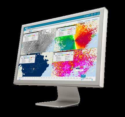
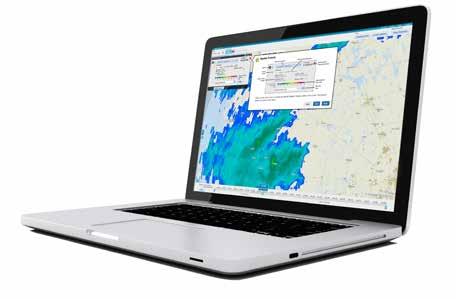
3 Experience More IRIS Focus Weather Radar Software has a modern display and a rich set of tools for viewing and analyzing your weather radar data like never before. Developed with customers, the easy-to-use interface reduces complexity and training time. IRIS Focus helps you better understand storms for quicker decisions and more accurate precipitation estimation and classification.
4 Analyze Your Data Faster IRIS Focus allows you to see more. Choose a multi-panel display or layer multiple data points from different radar products on one screen. Because we generate radar products on-demand, you can zoom in on data at the highest resolution. ANALYZE YOUR DATA FASTER
5
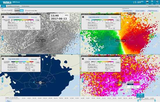
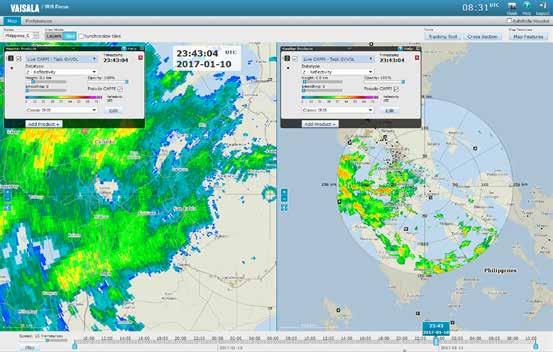
6 See More with the Multi-Panel Display Display up to four radar products within the same window to see all the significant details of the weather at once Synchronize time and location of displayed panels Synchronize displayed panel animation Move the cursor to a different location on the map all displayed panels move together ANALYZE YOUR DATA FASTER
7
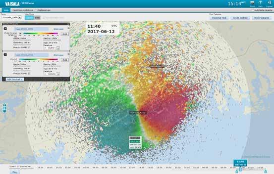
8 Understand More by Overlaying Multiple Data Points Layer multiple data such as radar reflectivity and radial velocity See radial winds and intensity simultaneously Set height, smoothing, opacity, and data type in layer settings ANALYZE YOUR DATA FASTER
9
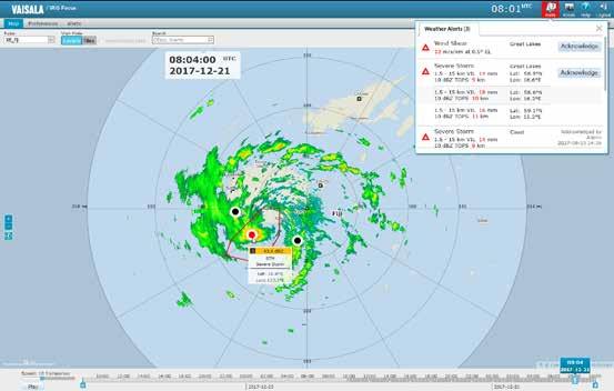
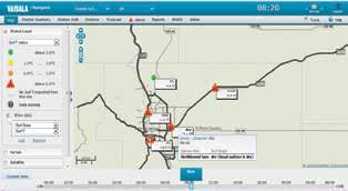
10 Weather Warnings and Alerts Automatically detect weather hazards as they appear Receive an alert when a significant weather event (such as hail, wind shear, or heavy rain) appears in your area of responsibility Configure the alerts to use your terminology and language to speed up the response no interpretation is needed ANALYZE YOUR DATA FASTER
11
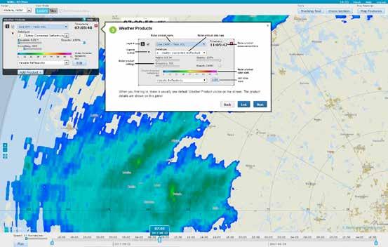
12 Generate High Resolution Products On-Demand Generate on-demand and pre-configured radar products Display data at the highest possible resolution for the given screen space Zoom in and data will be re-generated to increase the resolution Adjust on-demand product settings, such as CAPPI heights interactively, add smoothing, and select data variables ANALYZE YOUR DATA FASTER
13
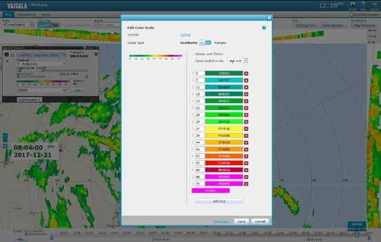
14 Use Color Options to Prevent Distortion Use the color scale editor to design color scales that do not distort the data by falsely highlighting certain colors Color palette goes beyond traditional red, green, and blue by adding hue and luminance control Administrators can set a standard scale for sharing across an agency ANALYZE YOUR DATA FASTER
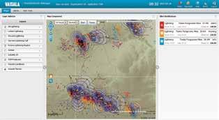
15
16 Understand Storms to Make Better Decisions IRIS Focus tools support quicker decision making and accurate precipitation estimation and classification. Advanced graphic display and data processing capabilities provide new ways of observing your weather radar data. BETTER UNDERSTANDING OF WEATHER

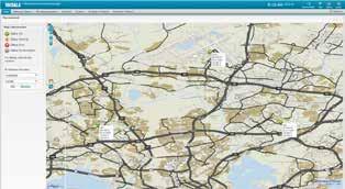
17
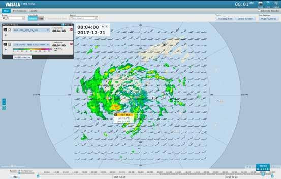
18 Nowcasting Automated short term forecasting predicts precipitation movement and gives you time to prepare hours in advance Support forecasters by visualizing the near future Seamless integration to the on-demand product generation and user interface for the best flexibility of weather analysis BETTER UNDERSTANDING OF WEATHER
19
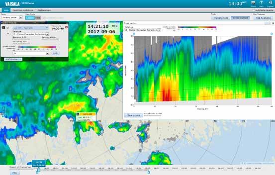
20 Observe the Vertical Structure of Storms Understand storm motion and growth by using the cross-section tool to see data at different altitudes with respect to other data points Improve your interpretation of the three dimensional area and a storm s evolution in time Perform curved cross-sections to analyze frontal boundaries and curved rain bands BETTER UNDERSTANDING OF WEATHER
21
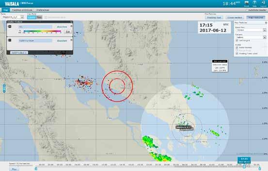
22 Display Data Outside the Radar Range Extend observations to show convective storms beyond the radar range Layer other weather data, such as lightning data from Vaisala s Global Lightning Dataset GLD360 outside of the range of the radar BETTER UNDERSTANDING OF WEATHER
23
24 Spatial Awareness Locate weather data with respect to geographical features for better situational awareness Geographic Information System (GIS) datasets are continuously updated using Open Source GeoServer Add your own GIS data sets Support for Multiple maps BETTER UNDERSTANDING OF WEATHER
25
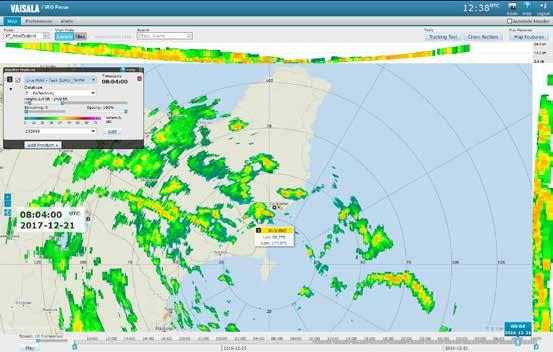
26 On-demand Radar Products New interactive on-demand radar products (MAX, BASE, THICK and TOPS) Select the radar parameters and adjust the visualization details to focus on what matters most Use the Cursor Tool to easily see the data magnitude by placing the mouse over the weather pattern no need to rely on the legend BETTER UNDERSTANDING OF WEATHER
27
28 Access your Data Anywhere Because IRIS Focus is web-based, you can access your data from anywhere. You do not have to store data on your computer easily share your data with colleagues in other departments and outside the agency. INCREASE ACCESSIBILITY

29
30 Access Your Data from Anywhere IRIS Focus is web-based, allowing you to access your data from anywhere Data does not have to be stored on your computer Easily share your data with colleagues in other departments and outside the agency INCREASE ACCESSIBILITY
31 IRIS Radar (Site A) IRIS Radar (Site B) IRIS Radar (Site C) IRIS Radar (Nth Site) Network Data Communication TCP/IP Centralized Data Center IRIS Analysis (Radar Product Generator) IRIS Focus, IRIS Vision Webservers & Geoserver License Server GLD360 Lightning Data (Vaisala GLD360 Subscription) Network Data Communication (HTTPS) Up to 500 Simultaneous Connections User 1 (On Site) User 2 (Office) User 3 (Remote) Nth User (Other Location)
32 Tool Tips and Localized Context-Sensitive Help Interactive step-by-step tutorials reduce training time Built-in tool tips and context-sensitive help aid throughout Available languages: English, Spanish, Portuguese, and Russian are available More languages can be added on request INCREASE ACCESSIBILITY
33
34 Vaisala Total Offering One-stop-shop system provider Reduces training time and allows seamless transition between two or more Vaisala products Vaisala products that use same platform: Observation Network Manager, AviMet, Thunderstorm Manager, RoadDSS Manager and DigiCORA Sounding System MW41 INCREASE ACCESSIBILITY
35 THUNDERSTORM MANAGER OBSERVATION NETWORK MANAGER ROADDSS NAVIGATOR
36 Experience More.
The next generation in weather radar software.
 The next generation in weather radar software. PUBLISHED BY Vaisala Oyj Phone (int.): +358 9 8949 1 P.O. Box 26 Fax: +358 9 8949 2227 FI-00421 Helsinki Finland Try IRIS Focus at iris.vaisala.com. Vaisala
Lightning Safety in a Flash / VAISALA AIRPORT LIGHTNING INFORMATION SYSTEM (ALIS)
") Lightning Safety in a Flash / VAISALA AIRPORT LIGHTNING INFORMATION SYSTEM (ALIS) Global Threat to Airports Proven. Global. The Vaisala Airport Lightning Information System (ALIS) opens a new era of universal
Lightning Safety in a Flash / VAISALA AIRPORT LIGHTNING INFORMATION SYSTEM (ALIS) Global Threat to Airports Proven. Global. The Vaisala Airport Lightning Information System (ALIS) opens a new era of universal
Unique Vaisala Global Lightning Dataset GLD360 TM
 Unique Vaisala Global Lightning Dataset GLD360 TM / THE ONLY LIGHTNING DETECTION NETWORK CAPABLE OF DELIVERING HIGH-QUALITY DATA ANYWHERE IN THE WORLD GLD360 provides high-quality lightning data anywhere
Unique Vaisala Global Lightning Dataset GLD360 TM
 Unique Vaisala Global Lightning Dataset GLD360 TM / THE ONLY LIGHTNING DETECTION NETWORK CAPABLE OF DELIVERING SUCH HIGH-QUALITY DATA ANYWHERE IN THE WORLD GLD360 provides high-quality lightning data anywhere
VAISALA RADIOSONDE RS41 COVER IMPROVEMENT
 VAISALA RADIOSONDE RS41 COVER IMPROVEMENT White Paper B211661EN-A PUBLISHED BY Vaisala Oyj Phone (int.): +358 9 8949 1 P.O. Box 26 Fax: +358 9 8949 2227 FI-00421 Helsinki Finland Visit our website at www.vaisala.com
Smart use of Geographic Information System (GIS) platform for delivering weather information and nowcasting services
 platform for delivering weather information and nowcasting services") Smart use of Geographic Information System (GIS) platform for delivering weather information and nowcasting services C. K. Pan Hong Kong Observatory Hong Kong, China It is a world of beauty Source: Image
Smart use of Geographic Information System (GIS) platform for delivering weather information and nowcasting services C. K. Pan Hong Kong Observatory Hong Kong, China It is a world of beauty Source: Image
Vaisala AviMet Automated Weather Observing System
 Vaisala AviMet Automated Weather Observing System Solutions to meet your challenges Our mission: to help you operate succesfully Safe, economical, reliable and flexible operation of your airport is ensured
A SMART SYSTEM FRAMEWORK ENABLING AN INNOVATIVE WEATHER AWARENESS SYSTEM FOR AIRPORTS AND BEYOND
 A SMART SYSTEM FRAMEWORK ENABLING AN INNOVATIVE WEATHER AWARENESS SYSTEM FOR AIRPORTS AND BEYOND Christian Schiefer, Sebastian Kauczok, Andre Weipert WSN16 WMO WWRP 4th International Symposium on Nowcasting
baltrad Mass media Overview
 48 Mass media Overview Weather information disseminated through mass media, like press, TV, and Internet is intended for its recipients, not for the media themselves. Therefore the addressees of the media
ERAD THE SIXTH EUROPEAN CONFERENCE ON RADAR IN METEOROLOGY AND HYDROLOGY
 Radar and lightning data based classification scheme for the severity of convective cells Pekka Rossi 1, Kalle Halmevaara 2, Antti Mäkelä 1, Jarmo Koistinen 1, Vesa Hasu 2 1. Finnish Meteorological Institute,
Instituto de Pesquisas Meteorológicas - IPMet Universidade Estadual Paulista - Unesp
 IPMET WEB GIS APPLICATION FOR SEVERE WEATHER ALERT AND DECISION SUPPORT Jaqueline Murakami Kokitsu Instituto de Pesquisas Meteorológicas - IPMet Universidade Estadual Paulista - Unesp IPMet/Unesp Meteorological
Comparison of Vaisala Radiosondes RS41 and RS92 WHITE PAPER
 Comparison of Vaisala Radiosondes RS41 and RS92 WHITE PAPER Table of Contents CHAPTER 1 Introduction... 4 CHAPTER 2 Key Improvements in RS41... 5 CHAPTER 3 RS41 and RS92 Comparison Tables... 6 CHAPTER
AWOS. Automated Weather Observing Systems COASTAL
 AWOS Automated Weather Observing Systems COASTAL Environmental Systems Monitor Monitor Your Your World World Coastal s Experience & Expertise Since 1981, Coastal Environmental Systems, Inc. (Coastal) has
CLIMATE CHANGE ADAPTATION BY MEANS OF PUBLIC PRIVATE PARTNERSHIP TO ESTABLISH EARLY WARNING SYSTEM
 CLIMATE CHANGE ADAPTATION BY MEANS OF PUBLIC PRIVATE PARTNERSHIP TO ESTABLISH EARLY WARNING SYSTEM By: Dr Mamadou Lamine BAH, National Director Direction Nationale de la Meteorologie (DNM), Guinea President,
The Vaisala AUTOSONDE AS41 OPERATIONAL EFFICIENCY AND RELIABILITY TO A TOTALLY NEW LEVEL.
 The Vaisala AUTOSONDE AS41 OPERATIONAL EFFICIENCY AND RELIABILITY TO A TOTALLY NEW LEVEL. Weather Data Benefit For Society The four most important things about weather prediction are quality, reliability,
Using McIDAS-V for Satellite-Based Thunderstorm Research and Product Development
 Using McIDAS-V for Satellite-Based Thunderstorm Research and Product Development Kristopher Bedka UW-Madison, SSEC/CIMSS In Collaboration With: Tom Rink, Jessica Staude, Tom Whittaker, Wayne Feltz, and
Among various open-source GIS programs, QGIS can be the best suitable option which can be used across partners for reasons outlined below.
 Comparison of Geographic Information Systems (GIS) software As of January 2018, WHO has reached an agreement with ESRI (an international supplier of GIS software) for an unlimited use of ArcGIS Desktop
McIDAS-V Tutorial Displaying Point Observations from ADDE Datasets updated July 2016 (software version 1.6)
") McIDAS-V Tutorial Displaying Point Observations from ADDE Datasets updated July 2016 (software version 1.6) McIDAS-V is a free, open source, visualization and data analysis software package that is the
McIDAS-V Tutorial Displaying Point Observations from ADDE Datasets updated July 2016 (software version 1.6) McIDAS-V is a free, open source, visualization and data analysis software package that is the
MetConsole AWOS. (Automated Weather Observation System) Make the most of your energy SM
 Make the most of your energy SM") MetConsole AWOS (Automated Weather Observation System) Meets your aviation weather needs with inherent flexibility, proven reliability Make the most of your energy SM Automated Weather Observation System
MetConsole AWOS (Automated Weather Observation System) Meets your aviation weather needs with inherent flexibility, proven reliability Make the most of your energy SM Automated Weather Observation System
Vaisala Weather Radar.
 Vaisala Weather Radar. You will see more. Your next weather radar. We chose the new Vaisala radar as we believe it s the best on the market. The new Vaisala radars and software tools are warmly welcomed
What is CERA? Coastal Emergency Risks Assessment
 What is CERA? Coastal Emergency Risks Assessment Visualization tool using OGC standards Displays the outputs from the ADCIRC storm surge model or other coastal models Represents the maps on interactive
L.S. Lee* Hong Kong Observatory, Hong Kong, China
 2.5 COMPREHENSIVE AND LOCATION-SPECIFIC LIGHTNING INFORMATION SERVICE IN HONG KONG L.S. Lee* Hong Kong Observatory, Hong Kong, China 1. INTRODUCTION The Hong Kong Observatory (HKO) set up a lightning location
ADL110B ADL120 ADL130 ADL140 How to use radar and strike images. Version
 ADL110B ADL120 ADL130 ADL140 How to use radar and strike images Version 1.00 22.08.2016 How to use radar and strike images 1 / 12 Revision 1.00-22.08.2016 WARNING: Like any information of the ADL in flight
ArcGIS. for Server. Understanding our World
 ArcGIS for Server Understanding our World ArcGIS for Server Create, Distribute, and Manage GIS Services You can use ArcGIS for Server to create services from your mapping and geographic information system
ON LINE ARCHIVE OF STORM PENETRATING DATA
 ON LINE ARCHIVE OF STORM PENETRATING DATA Matthew Beals, Donna V. Kliche, and Andrew G. Detwiler Institute of Atmospheric Sciences, South Dakota School of Mines and Technology, Rapid City, SD Steve Williams
WeatherWatcher ACP. Astronomers Control Panel (V4 or >) Ambient Virtual Weather Station (Pro or Internet editions) ASCOM platform v4.
 Ambient Virtual Weather Station (Pro or Internet editions) ASCOM platform v4.") WeatherWatcher ACP Software This is a minimum equipment list: Astronomers Control Panel (V4 or >) Ambient Virtual Weather Station (Pro or Internet editions) ASCOM platform v4.1 or higher Hardware Weather
WeatherWatcher ACP Software This is a minimum equipment list: Astronomers Control Panel (V4 or >) Ambient Virtual Weather Station (Pro or Internet editions) ASCOM platform v4.1 or higher Hardware Weather
: : User Manual: : - 10 December
 : : User Manual: : - 0 December 06 - : : User Manual: : Table of Contents. Map Control. How to move a map. How to zoom in and out a map 4. How to inquire Ocean Currents. How to inquire predicted current
National Public Weather and Warning Services in the Swaziland Meteorological Service Dennis S.Mkhonta /
 National Public Weather and Warning Services in the Swaziland Meteorological Service Dennis S.Mkhonta dennis.mkhonta@gmail.com / dennis@swazimet.gov.sz Introduction Swaziland s geographical position exposes
IMS4 ARWIS. Airport Runway Weather Information System. Real-time data, forecasts and early warnings
 Airport Runway Weather Information System Real-time data, forecasts and early warnings Airport Runway Weather Information System FEATURES: Detection and prediction of runway conditions Alarms on hazardous
Meridian Environmental Technology, Inc.
 Meridian Environmental Technology, Inc. Providing Tomorrow s Technology Today Meridian is committed to the support of its clients through advancement of science and technology A National Leader in Road
Let's Make Our Cities Breathable BECAUSE CLEAN AIR BELONGS TO EVERYONE.
 Let's Make Our Cities Breathable BECAUSE CLEAN AIR BELONGS TO EVERYONE. Clean Air is a Human Right that Everyone Should be Entitled to Making cities more breathable starts by measuring, analyzing and understanding
VAISALA GLOBAL LIGHTNING DATASET GLD360
 VAISALA GLOBAL LIGHTNING DATASET GLD360 Technology, operations, and applications overview JULY 2009 MIke Grogan Application Services Manager Observation Services Nick Demetriades Applications Manager,
Integrated Electricity Demand and Price Forecasting
 Integrated Electricity Demand and Price Forecasting Create and Evaluate Forecasting Models The many interrelated factors which influence demand for electricity cannot be directly modeled by closed-form
Your Source for Global Aviation Forecasts
 Your Source for Global Aviation Forecasts (831) 238-5054 100 Sky Park Drive Monterey, CA 93940 Weather4Cast.com Live Weather Data Feeds Weather4Cast.com provides Live Aviation Weather Data Feeds formatted
Monitoring Extreme Weather Events. February 8, 2010
 Monitoring Extreme Weather Events February 8, 2010 Extensive network of over 800 stations across the Prairies Good coverage across entire agriculture production region Network of networks strategy includes
ArcGIS Pro: Essential Workflows STUDENT EDITION
 ArcGIS Pro: Essential Workflows STUDENT EDITION Copyright 2018 Esri All rights reserved. Course version 6.0. Version release date August 2018. Printed in the United States of America. The information contained
Importance of Technology as part of the NWS New Orleans/Baton Rouge Impact- Based Decision Support Pilot Project
 Importance of Technology as part of the NWS New Orleans/Baton Rouge Impact- Based Decision Support Pilot Project NWS New Orleans Meteorologist-In-Charge: Ken Graham Emergency Response Specialist Team:
13.2 USING VIRTUAL GLOBES TO IMPROVE SITUATIONAL AWARENESS IN THE NATIONAL WEATHER SERVICE
 13.2 USING VIRTUAL GLOBES TO IMPROVE SITUATIONAL AWARENESS IN THE NATIONAL WEATHER SERVICE Andy Foster* National Weather Service Springfield, Missouri* Keith Stellman National Weather Service Shreveport,
MeteoGroup RoadMaster. The world s leading winter road weather solution
 MeteoGroup RoadMaster The world s leading winter road weather solution Discover why RoadMaster is the world s leading winter road weather solution. Managing winter road maintenance means that you carry
GIS for Crime Analysis. Building Better Analysis Capabilities with the ArcGIS Platform
 GIS for Crime Analysis Building Better Analysis Capabilities with the ArcGIS Platform Crime Analysis The Current State One of the foundations of criminological theory is that three things are needed for
FloodAlert: A Simplified Radar-Based EWS For Urban Flood Warning
 City University of New York (CUNY) CUNY Academic Works International Conference on Hydroinformatics 8-1-2014 FloodAlert: A Simplified Radar-Based EWS For Urban Flood Warning Xavier Llort Rafael Sánchez-Diezma
Crime Analysis. GIS Solutions for Intelligence-Led Policing
 Crime Analysis GIS Solutions for Intelligence-Led Policing Applying GIS Technology to Crime Analysis Know Your Community Analyze Your Crime Use Your Advantage GIS aids crime analysis by Identifying and
Improvement of ASECNA nowcasting and MET services through SAAPI solution
 Loïc Le Gallou, MFI Thomas Sobakam, ASECNA Saly, Senegal, November 28 th, 2018 Improvement of ASECNA nowcasting and MET services through SAAPI solution SUMMARY 1. About SAAPI Project : needs and solution
SWAN The Operational System for Nowcasting and Very-short Range Forecast in CMA
 SWAN The Operational System for Nowcasting and Very-short Range Forecast in CMA National Meteorological Center (NMC) China Meteorological Administration (CMA) Mao Dongyan, Zheng Yuanyuan, Zhou Kanghui
* * * Table (1) Table (2)
 Table (2)") A step Forward to Atomize the Sudan Meteorological Authority (SMA) Net work Y.S. Odan Surface Instruments Department Tel: 00249 912220246 E-mail yaseen@ersad.gov.sd Abstract AWS has been introduced to
A step Forward to Atomize the Sudan Meteorological Authority (SMA) Net work Y.S. Odan Surface Instruments Department Tel: 00249 912220246 E-mail yaseen@ersad.gov.sd Abstract AWS has been introduced to
Use of lightning data to improve observations for aeronautical activities
 Use of lightning data to improve observations for aeronautical activities Françoise Honoré Jean-Marc Yvagnes Patrick Thomas Météo_France Toulouse France I Introduction Aeronautical activities are very
Introduction to Weather Analytics & User Guide to ProWxAlerts. August 2017 Prepared for:
 Introduction to Weather Analytics & User Guide to ProWxAlerts August 2017 Prepared for: Weather Analytics is a leading data and analytics company based in Washington, DC and Dover, New Hampshire that offers
Road weather forecasts and MDSS in Slovakia
 ID: 0030 Road weather forecasts and MDSS in Slovakia M. Benko Slovak Hydrometeorological Institute (SHMI), Jeséniova 17, 83315 Bratislava, Slovakia Corresponding author s E-mail: martin.benko@shmu.sk ABSTRACT
Renewable Energy Development and Airborne Wildlife Conservation
 Whitepaper ECHOTRACK TM RADAR ACOUSTIC TM SURVEILLANCE SYSTEM Renewable Energy Development and Airborne Wildlife Conservation Renewable energy developers must meet regulatory requirements to mitigate for
Recent Developments of the NinJo Workstation
 Recent Developments of the NinJo Workstation Gerhard Eymann, DWD, FEZE gerhard.eymann@dwd.de 13 th Workshop on Meteorological Operational Systems ECMWF Reading, UK Oct. 31 - Nov. 4, 2011 Selected Recent
Enabling ENVI. ArcGIS for Server
 Enabling ENVI throughh ArcGIS for Server 1 Imagery: A Unique and Valuable Source of Data Imagery is not just a base map, but a layer of rich information that can address problems faced by GIS users. >
Moroccan lightning detection network, topology, performance and management of the network
 Moroccan lightning detection network, topology, performance and management of the network Mohamed DAHOUI, Mohamed NBOU and Rabia MERROUCHI Moroccan Meteorological Center Tel (212)71302837, Fax: (212)22908593
Guide to Hydrologic Information on the Web
 NOAA s National Weather Service Guide to Hydrologic Information on the Web Colorado River at Lees Ferry Photo: courtesy Tim Helble Your gateway to web resources provided through NOAA s Advanced Hydrologic
B KMD 550/850 Multi-Function Display Quick Reference For Software Version 01/14 or Later
 F N B KMD 550/850 Multi-Function Display Quick Reference For Software Version 01/14 or Later 12 1 11 2 3 4 10 13 9 6 5 7 1. Brightness Control 2. Data Card 3. Display 4. Available Functions Legend 5. On/Off
June 17, 2015 Lab Exercise
 June 17, 2015 Lab Exercise Objective: To become comfortable with: Interpreting heavy rainfall forecast products and ingredients before an event (Part 1) Monitoring key heavy rainfall products during an
Shaping future approaches to evaluating highimpact weather forecasts
 Shaping future approaches to evaluating highimpact weather forecasts David Richardson, and colleagues Head of Evaluation, Forecast Department European Centre for Medium-Range Weather Forecasts (ECMWF)
Irma Ylikangas Application Manager M.Sc., (Chem. Eng)
") Customized user interface for weather and environmental information to improve safety of industrial areas and harbours; Kokkola Industrial Park (KIP) weather Pilot Irma Ylikangas Application Manager M.Sc.,
Customized user interface for weather and environmental information to improve safety of industrial areas and harbours; Kokkola Industrial Park (KIP) weather Pilot Irma Ylikangas Application Manager M.Sc.,
Complete Weather Intelligence for Public Safety from DTN
 Complete Weather Intelligence for Public Safety from DTN September 2017 White Paper www.dtn.com / 1.800.610.0777 From flooding to tornados to severe winter storms, the threats to public safety from weather-related
Lecture 3 GIS outputs. Dr. Zhang Spring, 2017
 Lecture 3 GIS outputs Dr. Zhang Spring, 2017 Model of the course Using and making maps Navigating GIS maps Map design Working with spatial data Geoprocessing Spatial data infrastructure Digitizing File
Vaisala s NLDN U.S. National Lightning Detection Network
 Vaisala s NLDN U.S. National Lightning Detection Network / Scientific Accuracy. Proven Reliability. Setting the Standard for Accuracy and Reliability. Lightning information you can trust Vaisala s NLDN
Animating Maps: Visual Analytics meets Geoweb 2.0
 Animating Maps: Visual Analytics meets Geoweb 2.0 Piyush Yadav 1, Shailesh Deshpande 1, Raja Sengupta 2 1 Tata Research Development and Design Centre, Pune (India) Email: {piyush.yadav1, shailesh.deshpande}@tcs.com
WSI Pilotbrief Optima - for ipad
 WSI Pilotbrief Optima - for ipad Anticipate, Visualize & Avoid Hazardous Weather In A Whole New Way The Weather Company, an IBM Business, delivers an ipad-based version of WSI Pilotbrief Optima. This ipad
Law Enforcement Solutions and Applications
 ArcGIS for Solutions and Applications Solutions and Applications ArcGIS for Platform ArcGIS for Collection of solutions and applications for law enforcement. Built on the ArcGIS platform. For any named
CHAPTER 22 GEOGRAPHIC INFORMATION SYSTEMS
 CHAPTER 22 GEOGRAPHIC INFORMATION SYSTEMS PURPOSE: This chapter establishes the administration and use of to improve the quality and accessibility of Department s spatial information and support graphical
Multi-Function Display Pilot s Guide Addendum
 Multi-Function Display Pilot s Guide Addendum Software Release 4.2 or Later 600-00344-000 Rev: 01-1- EX500/EX600 Document Revision History Date Revision Description February 21, 2018 00 Initial Release
TIFS DEVELOPMENTS INSPIRED BY THE B08 FDP. John Bally, A. J. Bannister, and D. Scurrah Bureau of Meteorology, Melbourne, Victoria, Australia
 P13B.11 TIFS DEVELOPMENTS INSPIRED BY THE B08 FDP John Bally, A. J. Bannister, and D. Scurrah Bureau of Meteorology, Melbourne, Victoria, Australia 1. INTRODUCTION This paper describes the developments
Data Aggregation with InfraWorks and ArcGIS for Visualization, Analysis, and Planning
 CI125230 Data Aggregation with InfraWorks and ArcGIS for Visualization, Analysis, and Planning Stephen Brockwell Brockwell IT Consulting Inc. Sean Kinahan Brockwell IT Consulting Inc. Learning Objectives
Overview of the Tropical Cyclone Guidance Project
 Overview of the Tropical Cyclone Guidance Project Dr. Jonathan L. Vigh With thanks to Mahsa Mirzargar (Univ. of Miami) Shanghai Typhoon Institute 09 July 2018 NCAR is sponsored by the National Science
Utilising Radar and Satellite Based Nowcasting Tools for Aviation Purposes in South Africa. Erik Becker
 Utilising Radar and Satellite Based Nowcasting Tools for Aviation Purposes in South Africa Erik Becker Morné Gijben, Mary-Jane Bopape, Stephanie Landman South African Weather Service: Nowcasting and Very
Afghanistan Resource Data and Geospatial Toolkit (GsT)
") Afghanistan Resource Data and Geospatial Toolkit (GsT) WISER Clean Energy Access Workshop Shannon Cowlin 22 March 2010 NREL is a national laboratory of the U.S. Department of Energy, Office of Energy Efficiency
Afghanistan Resource Data and Geospatial Toolkit (GsT) WISER Clean Energy Access Workshop Shannon Cowlin 22 March 2010 NREL is a national laboratory of the U.S. Department of Energy, Office of Energy Efficiency
Vaisala Blitzdetektion. Michael Kalkum
 Vaisala Blitzdetektion Michael Kalkum 12.11.2013 What Is Lightning? Lightning is a transient, high-current electrical discharge Lightning stroke is typically 30.000 C Lightning takes the path of least
Electrical thunderstorm nowcasting using lightning data mining
 Data Mining VII: Data, Text and Web Mining and their Business Applications 161 Electrical thunderstorm nowcasting using lightning data mining C. A. M. Vasconcellos 1, C. L. Curotto 2, C. Benetti 1, F.
GIS-BASED DISASTER WARNING SYSTEM OF LOW TEMPERATURE AND SPARE SUNLIGHT IN GREENHOUSE
 GIS-BASED DISASTER WARNING SYSTEM OF LOW TEMPERATURE AND SPARE SUNLIGHT IN GREENHOUSE 1,2,* 1,2 Ruijiang Wei, Chunqiang Li, Xin Wang 1, 2 1 Hebei Provincial Institute of Meteorology, Shijiazhuang, Hebei
Project AutoWARN. Automatic Support for the Weather Warning Service at DWD
 Automatic Support for the Weather Warning Service at DWD Bernhard Reichert Deutscher Wetterdienst, Referat FE ZE Email: bernhard.reichert@dwd.de Content Project AutoWARN Introduction and Overview AutoWARN
MetConsole LLWAS (Low Level Wind Shear Alert System)
") MetConsole LLWAS (Low Level Wind Shear Alert System) Enhancing aircraft safety under wind shear conditions Make the most of your energy SM MetConsole Low Level Wind Shear Alert System The Schneider Electric
MetConsole LLWAS (Low Level Wind Shear Alert System) Enhancing aircraft safety under wind shear conditions Make the most of your energy SM MetConsole Low Level Wind Shear Alert System The Schneider Electric
Reprint 797. Development of a Thunderstorm. P.W. Li
 Reprint 797 Development of a Thunderstorm Nowcasting System in Support of Air Traffic Management P.W. Li AMS Aviation, Range, Aerospace Meteorology Special Symposium on Weather-Air Traffic Management Integration,
Research on Lightning Warning with SAFIR Lightning Observation and Meteorological detection Data in Beijing-Hebei Areas
 Research on Lightning Warning with SAFIR Lightning Observation and Meteorological detection Data in Beijing-Hebei Areas Meng Qing 1 Zhang Yijun 1 Yao Wen 1 Zhu Xiaoyan 1 He Ping 1 Lv Weitao 1 Ding Haifang
Welcome! Power BI User Group (PUG) Copenhagen
 Copenhagen") Welcome! Power BI User Group (PUG) Copenhagen Making Maps in Power BI Andrea Martorana Tusa BI Specialist Welcome to Making maps in Power BI Who am I? First name: Andrea. Last name: Martorana Tusa. Italian,
Welcome! Power BI User Group (PUG) Copenhagen Making Maps in Power BI Andrea Martorana Tusa BI Specialist Welcome to Making maps in Power BI Who am I? First name: Andrea. Last name: Martorana Tusa. Italian,
MSGVIEW: AN OPERATIONAL AND TRAINING TOOL TO PROCESS, ANALYZE AND VISUALIZATION OF MSG SEVIRI DATA
 MSGVIEW: AN OPERATIONAL AND TRAINING TOOL TO PROCESS, ANALYZE AND VISUALIZATION OF MSG SEVIRI DATA Aydın Gürol Ertürk Turkish State Meteorological Service, Remote Sensing Division, CC 401, Kalaba Ankara,
Section 7: Hazard Avoidance
 7.1 In-Flight Hazard Awareness Section 7: Hazard Avoidance As technology improves, pilots have more and more real-time information within reach in all phases of flight. Terrain proximity, real-time weather
A Tale of Time Travel Year 2018
 A Tale of Time Travel Year 2018 1 1 Question: 2 2 Answer: Integrated Modeling for Road Condition Prediction (IMRCP) Kyle Garrett, Synesis Partners Nancy Powell, MoDOT/KC Scout 3 So what is it? Historic
DP Project Development Pvt. Ltd.
 Dear Sir/Madam, Greetings!!! Thanks for contacting DP Project Development for your training requirement. DP Project Development is leading professional training provider in GIS technologies and GIS application
Desktop GIS for Geotechnical Engineering
 Desktop GIS for Geotechnical Engineering Satya Priya Deputy General Manager (Software) RMSI, A-7, Sector 16 NOIDA 201 301, UP, INDIA Tel: +91-120-2511102 Fax: +91-120-2510963 Email: Satya.Priya@rmsi.com
ArcGIS Enterprise: Administration Workflows STUDENT EDITION
 ArcGIS Enterprise: Administration Workflows STUDENT EDITION Copyright 2019 Esri All rights reserved. Course version 1.1. Version release date April 2019. Printed in the United States of America. The information
Xinhua Liu National Meteorological Center (NMC) of China Meteorological Administration (CMA)
 of China Meteorological Administration (CMA)") The short-time forecasting and nowcasting technology of severe convective weather for aviation meteorological services in China Xinhua Liu National Meteorological Center (NMC) of China Meteorological Administration
The short-time forecasting and nowcasting technology of severe convective weather for aviation meteorological services in China Xinhua Liu National Meteorological Center (NMC) of China Meteorological Administration
Unit 5: NWS Hazardous Weather Products. Hazardous Weather and Flooding Preparedness
 Unit 5: NWS Hazardous Weather Products Objectives Describe the mission of the NWS Describe the basic organizational structure of the NWS Explain the purpose of various NWS products Explain how Probability
Counter-trafficking Integrated Display System (CIDS): A GIS-Based Command & Control Environment for Coalition Nations
: A GIS-Based Command & Control Environment for Coalition Nations") 9 th International Command and Control Research and Technology Symposium Counter-trafficking Integrated Display System (CIDS): A GIS-Based Command & Control Environment for Coalition Nations Elizabeth
9 th International Command and Control Research and Technology Symposium Counter-trafficking Integrated Display System (CIDS): A GIS-Based Command & Control Environment for Coalition Nations Elizabeth
Transactions on Information and Communications Technologies vol 18, 1998 WIT Press, ISSN
 STREAM, spatial tools for river basins, environment and analysis of management options Menno Schepel Resource Analysis, Zuiderstraat 110, 2611 SJDelft, the Netherlands; e-mail: menno.schepel@resource.nl
A BASE SYSTEM FOR MICRO TRAFFIC SIMULATION USING THE GEOGRAPHICAL INFORMATION DATABASE
 A BASE SYSTEM FOR MICRO TRAFFIC SIMULATION USING THE GEOGRAPHICAL INFORMATION DATABASE Yan LI Ritsumeikan Asia Pacific University E-mail: yanli@apu.ac.jp 1 INTRODUCTION In the recent years, with the rapid
For Military, Research, Tactical Portable Vehicle Mount Fixed Base
 For Military, Research, Military & Commercial Weather Applications Stations Tactical Portable Vehicle Mount Fixed Base WEATHERPAK Marine Weather Stations for Harsh Environments WEATHERPAK marine weather
0-6 hour Weather Forecast Guidance at The Weather Company. Steven Honey, Joseph Koval, Cathryn Meyer, Peter Neilley The Weather Company
 1 0-6 hour Weather Forecast Guidance at The Weather Company Steven Honey, Joseph Koval, Cathryn Meyer, Peter Neilley The Weather Company TWC Forecasts: Widespread Adoption 2 0-6 Hour Forecast Details 3
Development of a server to manage a customised local version of OpenStreetMap in Ireland
 Development of a server to manage a customised local version of OpenStreetMap in Ireland BłaŜej Ciepłuch 1, Jianghua Zheng 1, Peter Mooney 1,2, Adam C. Winstanley 1 1 Department of Computer Science, National
Thor Guard Data Reference Guide SUPPORT DOCUMENT
 1 THOR GUARD DATA REFERENCE GUIDE Background: A THOR GUARD Lightning Prediction System looks at the electrostatic charge of the atmosphere to determine when conditions are favorable for lightning to occur.
ERAD Czech weather radar data utilization for precipitation nowcasting. Proceedings of ERAD (2004): c Copernicus GmbH 2004
: c Copernicus GmbH 2004") Proceedings of ERAD (2004): 459 463 c Copernicus GmbH 2004 ERAD 2004 Czech weather radar data utilization for precipitation nowcasting P. Novák Czech Hydrometeorological Institute, Radar Department, Na
Proceedings of ERAD (2004): 459 463 c Copernicus GmbH 2004 ERAD 2004 Czech weather radar data utilization for precipitation nowcasting P. Novák Czech Hydrometeorological Institute, Radar Department, Na
GIS Frameworks in the National Weather Service
 GIS Frameworks in the National Weather Service Eugene Derner Senior Hydrologist NOAA/National Weather Service Missouri Basin River Forecast Center Agenda GIS Brief History In-house GIS Weather GIS Applications
Corporate. Information. Railway Infrastructure Administrator. Year indracompany.com
 geospatial and mobility Corporate Geographic Information System of ADIF Railway Infrastructure Administrator. Year 2009-2010 Corporate Geographic Information System of ADIF ADIF. Spanish Administrator
Thunderstorm Forecasting and Warnings in the US: Applications to the Veneto Region
 Thunderstorm Forecasting and Warnings in the US: Applications to the Veneto Region Bill Conway Vice President Weather Decision Technologies Norman, Oklahoma, USA Andrea Rossa ARPAV Lead Scientist Centre
2 November WSI Hubcast VERSION 3.5 USER GUIDE
 2 November 2016 WSI Hubcast VERSION 3.5 USER GUIDE THE WEATHER COMPANY WSI Hubcast 2 COPYRIGHT All Rights Reserved; Confidential Material. The Weather Company 400 Minuteman Road Andover, MA 01810 EXAMPLES
personal weather station
 personal weather station Master your own climate measurements on your smartphone TRAINING BOOK Pitch The Netatmo Personal Weather Station helps you master your own climate measurements on your smartphone.