and hydrological applications
|
|
|
- Shonda Black
- 5 years ago
- Views:
Transcription


1 Overview of QPE/QPF techniques and hydrological applications Siriluk Chumchean Department of Civil Engineering Mahanakorn University of Technology Typhoon Committee Roving Seminar 2011, Malaysia (20-23 September 2011) 1
2 Talk Structure Lecture A1: QPE techniques and development Real-time radar rainfall estimates t Case studies Lectuer A2: QPF techniques and development QPF techniques (Radar-based nowcasting) Operation and research development systems QPF accuracy assessment Case study : Bangkok rainfall forecasting system Lecture A3: Hydrological Applications Cases studies 2
3 Real-time Radar Rainfall Estimation i An Overview 3
4 Why do we need weather radar? Measure rainfall continuously covering large area Provide fine spatial and temporal resolution Can be used to project the storm trajectory, i.e., provide a short-term storm forecast 4
5 Basic concept of measuring rainfall using radars r p = C * K * Z r 2 z = AR b where: A,b radar parameters; Z reflectivity; R - rainfall 5
6 Volume scan data Range from radar (km) 6 Height above grou und (km)
7 Rhine Pixel 1 km² Radar site Intensity class scale (0 200 mm/hr) 7
8 Simplified scheme of radar processing Measurement of rain drops Reception of the reflection of the impulse sent out Radar image in polar coordinates - continuous values Transformation Radar products, e.g. in cartesian coordinates - values in 256 classes 8


9 Polar and cartesian coordinates Near distance <-> far distance Due to the radar measurement in polar coordinates, the data near to the radar are denser than far from the radar. When transforming polar data to a cartesian square grid, close to the radar several polar pixels are used. The spatial resolution of the square grid data is less than that of the originally measured polar data. Far from the radar, one polar pixel may be the original for several cartesian grid pixels. Here, the density of the data is less and therefore measurement errors have a higher impact on the cartesian data. 9


10 PPI PPI reflectivity map is extracted from the raw reflectivity data from the beam at a particular elevation angle. 10


11 CAPPI Constant Altitude Plan Precipitation Indicator (CAPPI) 11
12 Problems and Limitations Are parameters measurable? Are parameters stable? Does reliability stay constant with distance away a from the radar? What about obstructions (buildings, mountains)? What about multiple raindrops and rain-clouds in the path of the beam? What about the effect of the earth s curvature? What about differences in rain profile on ground versus high elevations? r Z = AR b where A,b radar parameters Z reflectivity R - rainfall 12
13 Problems of using weather radar? 1. Rfl Reflectivity tiit measurement error ground clutter attenuation vertical reflectivity it profile beam geometry 2. Reflectivity-rainfall rate conversion error 3. Residual errors when compared with rain gauges 13
14 Some difficulties Ground-clutter clutter, bright-band band, hail, attenuation, range dependent bias not so difficult to remove as they can be noticed easily No screening PE Partial screening PE Complete screening 14
15 Some difficulties Distance vs height of radar beam 8000 Heig ht of the rad dar beam (b beam centr re) [m] , Distance to radar location [km] 15
16 Some difficulties Increasing uncertainty in measured reflectivity as a function of range 1.0 tion Function (C CDF) Increasing range Cummu ulative Distribut Gauge rainfall Measured reflectivity Measured reflectivity (dbz) / Rainfall rate (dbr) 16
17 Some difficulties Range dependent errors 17
18 Some difficulties Range dependent errors 1 st Range 2 nd Range 1 st Range 2 nd Range σ σ = GR = σ σ = GR = ( R 70 ) ( R 70 ) GR GR 0 0 σ 2 GR i = 1 N { N [ () ()] () } 2 logrg i logrr i RG i > r i = 1 Anagnostou et al. (1999) 18

19 Some difficulties Attenuation example Rainfield attenuated (up to 6 classes) Rainfield without attenuation Marienfeld Radar Flechtdorf Radar Essen Einfalt (2004) 19

20 Some difficulties Bright-band Fabry et al. (1994) 20
21 Some difficulties..effect of storm types on Z-R relation Z = α 0 N o e Λ α Λ D D R = N e π ν ( D ) D 6 dd 4 3 o 2 0 D 3 dd Convective Stratiform Z = 35 dbz R = 7 mm/h Z = 35 dbz R = 10 mm/h 21
22 Z-R relationship for each rain-cloud Parameters a and b varies on rain drop size distribution. Cumulus Cumulonimbus Nimbostratus 22
 Cumulonimbus Radar refle ectivity (dbz) Nimbostratus Rain gauge rainfall (mm/hr) Rain")
 Cumulonimbus Rain gauge rainfall (mm/hr) Rain gauge rainfall (mm/hr) Chumchean et al.")
23 Z-R relationship of each type of rain-cloud (Calibration) Radar refle ectivity (dbz) Cumulus Radar refle ectivity (dbz) Cumulonimbus Radar refle ectivity (dbz) Nimbostratus Rain gauge rainfall (mm/hr) Rain gauge rainfall (mm/hr) Rain gauge rainfall (mm/hr) Radar re eflectivity (db BZ) Cumulus Radar re eflectivity (db BZ) Cumulonimbus Rain gauge rainfall (mm/hr) Rain gauge rainfall (mm/hr) Chumchean et al. (2009) 23
24 Z-R relationship of each type of rain-cloud Rainy season Cumulus Cumulonimbus Nimbostratus Z=29R 1.5 Z=55R 1.5 Z=208R 1.5 Z = 30 dbz Z = 30 dbz Z = 30 dbz R = mm/h R = 6.90 mm/h R = 2.85 mm/h Summer Cumulus Z=38R 1.5 Cumulonimbus Z=90R 1.5 Chumchean et al. (2009) Z = 30 dbz R = 8.93 mm/h Z = 30 dbz R = 4.99 mm/h 24
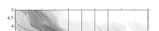
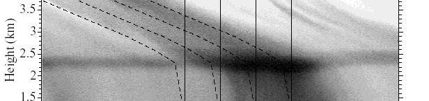
25 Some difficulties 8 9 Variations in Z~R 4 3 relationships for different 2 1 storm types ht (km) Heig stratiform tif Reflectivity (dbz) Height (km) convective Reflectivity (dbz) 25
26 Some difficulties Residual errors results in a mean-field-bias Exhibits persistence from one time-step to the next Very important in real-time estimation Difficult to remove using physical relations 26
27 Philosophy Estimated radar rainfall must first be corrected for reflectivity measurement errors and Z-R conversion errors based on the physical methods, and then a statistical method will be used to remove the average difference (mean field bias) between radar estimates at the rain gauge locations and the corresponding gauge rainfall amounts. 27
28 Real-time radar rainfall estimation method Reflectivity measurements Z-R conversion Rain gauge adjustment Record reflectivity field in 3D polar coordinate at operational temporal resolution Exclude reflectivity that are greater or lower than the maximum/minimum reflectivity thresholds Conversion to CAPPI Cartesian coordinate at altitude below bright-band level Remove the effect of ground and sea clutter Scaling correction Instantaneous storm classification Instantaneous convective/ stratiform reflectivity Account for the storm movement within an hour Z-R conversion Z=AR b Instantaneous convective/ stratiform radar rainfall Initial hourly radar rainfall estimates Accumulate into hourly radar rainfall Estimate hourly gauge-radar bias adjustment factor (AF) based on Kalman filtering approach proposed p by (Chumchean et al., 2003) [under review] Final hourly radar rainfall = AF initial radar rainfall estimates Chumchean et al. (2006) 28
29 Real-time radar rainfall estimation Scaling correction (to remove range-dependent bias) + Storm classification (to remove bias in Z~R relation due to the dominant storm type) + Correction of residual mean-field bias 29


30 Data C-band Kurnell radar 10-minute, 1km 2 resolution Analysis period November 2000 to April hourly rain gauges (SWC,SCA,BoM) 30
31 Correction of range dependent bias due to radar beam geometry 31
 Cumm mulative Dis 1.0 0.8 0.6 0. 4 0.2 0.")
 Assume simple scaling holds for")
32 Application of scaling in measured reflectivity tribution Fu nction (CDF F) Cumm mulative Dis km km km km km Measured reflectivity (db Z) Assume simple scaling holds for measured reflectivity 32
33 Scale transformation function The proposed scale transformation formula is : 1.0 Cummulati ve Distributi on Function n (CDF) km km km km km Transform ed reflectivity (db Z) 33
34 Range-dependent bias correction Using simple-scaling theory 1 : 27 8 Reflectivity (db BZ) l (mm/h) gauge rainfall Rain R ange interval (km ) 0 M easured reflectivity Transformed reflectivity R ain gauge rainfall 1 Chumchean et al, 2004, J Atmospheric and Oceanic Technology 34
35 Effectiveness of scale transformation function in correcting range dependent bias in radar rainfall Gaug ge-radar ra atio (G/R) Slope = 0.3 % Slope = 8.9 % Range interval (km) 35
36 Effect of storm types on radar rainfall Estimates (Z-R conversion error) 36


37 Instantaneous pixel classification Apply Steiner et al.(1995) storm classification method to use for separation of instantaneous reflectivity of each pixel into convective or stratiform components convective Revise the classification criteria to be suitable for instantaneous reflectivity of the Kurnell radar 37
38 Parameter for pixel classification (after Steiner et al., 1995 ) convective centre... background radius convective radius x minimum convective threshold* maximum stratiform threshold* convective radius Background radius 11 km * = proposed additional classification parameter 38


39 Classification results: calibration Using modified Parameters based on Steiner et al. (1995) Using modified pixel based classification approach 39


40 Classification results: verification Using modified Parameters based on Steiner et al. (1995) Using modified pixel based classification approach 40
41 Verification using VPR Height (km).. Height (km) (a) Stratiform Calibration: 20 Apr 01 at 14:35 UTC Verification1: 30 Jan 01 at 12:25 UTC Verification2: 10 Feb 07 at 18:35 UTC (b) Convective Reflectivity (dbz) Calibration: 20 Apr 01 at 14:35 UTC Verification1: 30 Jan 01 at 12:25 UTC Verification2: 10 Feb 07 at 18:35 UTC Reflectivity (dbz) 41
42 Correcting for mean field bias in real-time radar rainfall estimates using Kalman Filtering techniques? Rain gauge rainfall (G) = AF x Radar rainfall (R) AF = adjustment factor or mean field bias 42
43 Advantage of Kalman filtering technique over the simple G/R 1) It accounts for the noise in the measurements when updating the mean bias. 2) It provides an estimateof t the error in the computed tdbias. 3) It combines an estimate of the bias and its error variance made an hour earlier with the current measurements and its estimated measurement error variance to compute an updated bias estimate and new forecast for the next hour. Time update ˆ β t and - P t Measurement update βˆt and P t 43
44 Residual mean-field bias correction 1 Logarithmic Mean Field Bias (β) Assumed β exhibits Markovian dependence (Kalman process model assumed AR1) Kalman measurement 1 error model specified 0 Bias β = t log 10 n 1 G i, t n i= 1 Ri, t K alman Filter Observed (G/R) as function of range Time step (hours) 1 Chumchean et al, 2006, Journal of Hydrology, 2 Chumchean et al, 2003, Physics and Chemistry of the Earth, 28(3),
45 Radar rainfall error variance model Chumchean et al. (2003) σ 2 Yi t = G +, t 0.14 ; for r i 55 km σ 2 ( ri 55) = G ; for r > 55 km i Y i +, t t p 45
46 Comparison of observed G/R and the Kalman-filter estimated bias (Calibration) Kalman Filter Observed (G/R) lag 1 correlation coefficient of innovation sequence = Bias Nov Dec Dec Jan-1 Feb Apr Time step (hours) 46
47 Comparison of observed G/R and the Kalman-filter estimated bias (Validation) 6 5 K alman Filter Observed (G/R) lag 1 correlation coefficient of innovation sequence = Bias Time step (hours) 47
48 Application Stepwise application of error correction strategies Base reflectivity data free of effects of ground-clutter, bright-beam, hail Total rain gauges Cross-validation performed by leaving fraction of rain gauges to evaluate predictive uncertainty t Performance statistic - Root Mean Square Error (RMSE) 48
49 Results Climatological Z-R parameters of convective and stratiform rainfall (Z = AR 1.5 ) A parameter Calibration strategies No scaling correction Scaling correction Convective Stratiform Convective Stratiform No-classification Hourly pixel classification
50 Results GHNBO GHNBO+SC GHNBO+SC+ZR RMSE (mm m) Without bias adjustment Kalman Filtering Sample G/R Gauge-based adjustment methods GHNBO Base data SC Scaling correction ZR Storm classification 50
51 Results a) No bias correction GHNBO GHNBO+SC GHNBO+SC+ZR b) sample G/R GHNBO GHNBO+SC GHNBO+SC+ZR c) Kalman filtering GHNBO GHNBO+SC GHNBO+SC+ZR 51
52 Conclusions A stepwise decrease in RMSE with added levels of error correction Correcting mean-field bias more important that correcting the other sources of errors Storm classification relatively more important than the correction of range dependent bias Kalman filtering much better than use of sample G/R correction, particularly l when calibration rain gauges are few 52
53 Conclusions Range dependent bias and storm-classification, though small, are certainly not insignificant Complete model (after mean-field bias correction) explains more than 50% variance of gauge rainfall This may be the best we will ever have remember we are comparing 1kmx1km grid averages to rainfall at a point! 53
QPE and QPF in the Bureau of Meteorology
 QPE and QPF in the Bureau of Meteorology Current and future real-time rainfall products Carlos Velasco (BoM) Alan Seed (BoM) and Luigi Renzullo (CSIRO) OzEWEX 2016, 14-15 December 2016, Canberra Why do
Improved radar QPE with temporal interpolation using an advection scheme
 Improved radar QPE with temporal interpolation using an advection scheme Alrun Jasper-Tönnies 1 and Markus Jessen 1 1 hydro & meteo GmbH & Co, KG, Breite Str. 6-8, 23552 Lübeck, Germany (Dated: 18 July
Application of Scaling in Radar Reflectivity for Correcting Range-Dependent Bias in Climatological Radar Rainfall Estimates
 OCTOBER 2004 CHUMCHEAN ET AL. 1545 Application of Scaling in Radar Reflectivity for Correcting Range-Dependent Bias in Climatological Radar Rainfall Estimates SIRILUK CHUMCHEAN School of Civil and Environmental
THE CHARACTERISTICS OF DROP SIZE DISTRIBUTIONS AND CLASSIFICATIONS OF CLOUD TYPES USING GUDUCK WEATHER RADAR, BUSAN, KOREA
 THE CHARACTERISTICS OF DROP SIZE DISTRIBUTIONS AND CLASSIFICATIONS OF CLOUD TYPES USING GUDUCK WEATHER RADAR, BUSAN, KOREA Dong-In Lee 1, Min Jang 1, Cheol-Hwan You 2, Byung-Sun Kim 2, Jae-Chul Nam 3 Dept.
Aurora Bell*, Alan Seed, Ross Bunn, Bureau of Meteorology, Melbourne, Australia
 15B.1 RADAR RAINFALL ESTIMATES AND NOWCASTS: THE CHALLENGING ROAD FROM RESEARCH TO WARNINGS Aurora Bell*, Alan Seed, Ross Bunn, Bureau of Meteorology, Melbourne, Australia 1. Introduction Warnings are
Flood Forecasting with Radar
 Flood Forecasting with Radar Miguel Angel Rico-Ramirez m.a.rico-ramirez@bristol.ac.uk Encuentro Internacional de Manejo del Riesgo por Inundaciones, UNAM, 22 th Jan 2013 Talk Outline Rainfall estimation
*Corresponding author address: Charles Barrere, Weather Decision Technologies, 1818 W Lindsey St, Norman, OK
 P13R.11 Hydrometeorological Decision Support System for the Lower Colorado River Authority *Charles A. Barrere, Jr. 1, Michael D. Eilts 1, and Beth Clarke 2 1 Weather Decision Technologies, Inc. Norman,
Improvement of quantitative precipitation estimates in Belgium
 Improvement of quantitative precipitation estimates in Belgium L. Delobbe, E. Goudenhoofdt, and B. Mohymont Royal Meteorological Institute of Belgium 1. Introduction In this paper we describe the recent
Huw W. Lewis *, Dawn L. Harrison and Malcolm Kitchen Met Office, United Kingdom
 2.6 LOCAL VERTICAL PROFILE CORRECTIONS USING DATA FROM MULTIPLE SCAN ELEVATIONS Huw W. Lewis *, Dawn L. Harrison and Malcolm Kitchen Met Office, United Kingdom 1. INTRODUCTION The variation of reflectivity
REQUIREMENTS FOR WEATHER RADAR DATA. Review of the current and likely future hydrological requirements for Weather Radar data
 WORLD METEOROLOGICAL ORGANIZATION COMMISSION FOR BASIC SYSTEMS OPEN PROGRAMME AREA GROUP ON INTEGRATED OBSERVING SYSTEMS WORKSHOP ON RADAR DATA EXCHANGE EXETER, UK, 24-26 APRIL 2013 CBS/OPAG-IOS/WxR_EXCHANGE/2.3
DETECTION AND FORECASTING - THE CZECH EXPERIENCE
 1 STORM RAINFALL DETECTION AND FORECASTING - THE CZECH EXPERIENCE J. Danhelka * Czech Hydrometeorological Institute, Prague, Czech Republic Abstract Contribution presents the state of the art of operational
Spaceborne and Ground-based Global and Regional Precipitation Estimation: Multi-Sensor Synergy
 Hydrometeorology and Remote Sensing Lab (hydro.ou.edu) at The University of Oklahoma Spaceborne and Ground-based Global and Regional Precipitation Estimation: Multi-Sensor Synergy Presented by: 温逸馨 (Berry)
Heavier summer downpours with climate change revealed by weather forecast resolution model
 SUPPLEMENTARY INFORMATION DOI: 10.1038/NCLIMATE2258 Heavier summer downpours with climate change revealed by weather forecast resolution model Number of files = 1 File #1 filename: kendon14supp.pdf File
Climatological Z-R relationship for radar rainfall estimation in the upper Ping river basin
 R ESEARCH A RTICLE doi:.236/scienceasia3-874.8.34. ScienceAsia 34 (8): 222 Climatological Z-R relationship for radar rainfall estimation in the upper Ping river basin Punpim Puttaraksa Mapiam, Nutchanart
A test bed for verification of a methodology to correct the effects of range dependent errors on radar estimates
 A test bed for verification of a methodology to correct the effects of range dependent errors on radar estimates S. Sebastianelli 1, F. Russo 1, F. Napolitano 1, L. Baldini 2 1 Dipartimento di Ingegneria
Assimilation of Doppler radar observations for high-resolution numerical weather prediction
 Assimilation of Doppler radar observations for high-resolution numerical weather prediction Susan Rennie, Peter Steinle, Mark Curtis, Yi Xiao, Alan Seed Introduction Numerical Weather Prediction (NWP)
Lab 6 Radar Imagery Interpretation
 Lab 6 Radar Imagery Interpretation Background Weather radar (radio detection and ranging) is another very useful remote sensing tool used in meteorological forecasting. Microwave radar was developed in
Study on the rainfall dependence structure using radar and rain gauge data
 International Workshop Advances in Statistical hydrology, May 23-25 2010, Taormina, Italy Study on the rainfall dependence structure using radar and rain gauge data V. Montesarchio, F. Russo, F. Napolitano
BY REAL-TIME ClassZR. Jeong-Hee Kim 1, Dong-In Lee* 2, Min Jang 2, Kil-Jong Seo 2, Geun-Ok Lee 2 and Kyung-Eak Kim 3 1.
 P2.6 IMPROVEMENT OF ACCURACY OF RADAR RAINFALL RATE BY REAL-TIME ClassZR Jeong-Hee Kim 1, Dong-In Lee* 2, Min Jang 2, Kil-Jong Seo 2, Geun-Ok Lee 2 and Kyung-Eak Kim 3 1 Korea Meteorological Administration,
TRMM PR Version 7 Algorithm
 TRMM PR Version 7 Algorithm (1) Issues in V6 and needs for V7 (2) Changes in V7 (3) Results (4) Future Issues PR Algorithm Team & JAXA/EORC 1 July 2011 TRMM Precipitation Radar Algorithm Flow Okamoto PR
Application of Radar QPE. Jack McKee December 3, 2014
 Application of Radar QPE Jack McKee December 3, 2014 Topics Context Precipitation Estimation Techniques Study Methodology Preliminary Results Future Work Questions Introduction Accurate precipitation data
Assessment of QPE results from 4 kw X-band Local Area Weather Radar (LAWR) evaluated with S-band radar data
 evaluated with S-band radar data") Assessment of QPE results from 4 kw X-band Local Area Weather Radar (LAWR) evaluated with S-band radar data Lisbeth Pedersen 1+3, Isztar. Zawadzki 2, Niels Einar Jensen 1 and Henrik Madsen 3, (1) DHI,
Assessment of QPE results from 4 kw X-band Local Area Weather Radar (LAWR) evaluated with S-band radar data Lisbeth Pedersen 1+3, Isztar. Zawadzki 2, Niels Einar Jensen 1 and Henrik Madsen 3, (1) DHI,
Strategic Radar Enhancement Project (SREP) Forecast Demonstration Project (FDP) The future is here and now
 Forecast Demonstration Project (FDP) The future is here and now") Strategic Radar Enhancement Project (SREP) Forecast Demonstration Project (FDP) The future is here and now Michael Berechree National Manager Aviation Weather Services Australian Bureau of Meteorology
Strategic Radar Enhancement Project (SREP) Forecast Demonstration Project (FDP) The future is here and now Michael Berechree National Manager Aviation Weather Services Australian Bureau of Meteorology
OPERA: Operational Programme for the Exchange of Weather Radar Information
 OPERA: Operational Programme for the Exchange of Weather Radar Information ALADIN-HIRLAM workshop, Toulouse Maud Martet 26-28 April 2016 OPERA: An EUMETNET Project EUMETNET: EIG of 31 European National
MAIN ATTRIBUTES OF THE PRECIPITATION PRODUCTS DEVELOPED BY THE HYDROLOGY SAF PROJECT RESULTS OF THE VALIDATION IN HUNGARY
 MAIN ATTRIBUTES OF THE PRECIPITATION PRODUCTS DEVELOPED BY THE HYDROLOGY SAF PROJECT RESULTS OF THE VALIDATION IN HUNGARY Eszter Lábó OMSZ-Hungarian Meteorological Service, Budapest, Hungary labo.e@met.hu
Radars, Hydrology and Uncertainty
 Radars, Hydrology and Uncertainty Francesca Cecinati University of Bristol, Department of Civil Engineering francesca.cecinati@bristol.ac.uk Supervisor: Miguel A. Rico-Ramirez Research objectives Study
Correction of Polarimetric Radar Reflectivity Measurements and Rainfall Estimates for Apparent Vertical Profile in Stratiform Rain
 1170 J O U R N A L O F A P P L I E D M E T E O R O L O G Y A N D C L I M A T O L O G Y VOLUME 52 Correction of Polarimetric Radar Reflectivity Measurements and Rainfall Estimates for Apparent Vertical
118 RECONSTRUCTION OF RADAR RFLECTIVITY IN CLUTTER AREAS
 8 RECONSTRUCTION OF RADAR RFLECTIVITY IN CLUTTER AREAS Shinju Park, Marc Berenguer Centre de Recerca Aplicada en Hidrometeorologia, Universitat Politècnica de Catalunya (BarcelonaTech), Barcelona, Spain..
On the use of radar rainfall estimates and nowcasts in an operational heavy rainfall warning service
 On the use of radar rainfall estimates and nowcasts in an operational heavy rainfall warning service Alan Seed, Ross Bunn, Aurora Bell Bureau of Meteorology Australia The Centre for Australian Weather
P3.4 POSSIBLE IMPROVEMENTS IN THE STANDARD ALGORITHMS FOR TRMM/PR
 P3.4 POSSIBLE IMPROVEMENTS IN THE STANDARD ALGORITHMS FOR TRMM/PR Nobuhiro Takahashi* and Toshio Iguchi National Institute of Information and Communications Technology 1. INTRODUCTION The latest version
Probabilistic Quantitative Precipitation Forecasts for Tropical Cyclone Rainfall
 Probabilistic Quantitative Precipitation Forecasts for Tropical Cyclone Rainfall WOO WANG CHUN HONG KONG OBSERVATORY IWTCLP-III, JEJU 10, DEC 2014 Scales of Atmospheric Systems Advection-Based Nowcasting
Radar-raingauge data combination techniques: A revision and analysis of their suitability for urban hydrology
 9th International Conference on Urban Drainage Modelling Belgrade 2012 Radar-raingauge data combination techniques: A revision and analysis of their suitability for urban hydrology L. Wang, S. Ochoa, N.
Measurements of a network of mobile radars during the experimental campaign of the HydroRad project
 ERAD 2012 - THE SEVENTH EUROPEAN CONFERENCE ON RADAR IN METEOROLOGY AND HYDROLOGY Measurements of a network of mobile radars during the experimental campaign of the HydroRad project Kalogiros J. 1, Anagnostou
Observational analysis of storms and flooding events in the Pacific Northwest. Introduction
 Observational analysis of storms and flooding events in the Pacific Northwest Jake Crouch UNCA ATMS Class of 2007 April 18, 2009 Cloud and Precipitation Processes and Patterns Group Introduction Average
Analysis of Radar-Rainfall Uncertainties and effects on Hydrologic Applications. Emad Habib, Ph.D., P.E. University of Louisiana at Lafayette
 Analysis of Radar-Rainfall Uncertainties and effects on Hydrologic Applications Emad Habib, Ph.D., P.E. University of Louisiana at Lafayette Motivation Rainfall is a process with significant variability
an experiment to assess the hydrological value of a portable X-band radar
 ERAD 12 - THE SEVENTH EUROPEAN CONFERENCE ON RADAR IN METEOROLOGY AND HYDROLOGY RAINSCANNER@Barcelona: an experiment to assess the hydrological value of a portable X-band radar Marc Berenguer1, Shinju
Assessment of Ensemble Forecasts
 Assessment of Ensemble Forecasts S. L. Mullen Univ. of Arizona HEPEX Workshop, 7 March 2004 Talk Overview Ensemble Performance for Precipitation Global EPS and Mesoscale 12 km RSM Biases, Event Discrimination
Rogers and Yau Chapter 12: Precipitation Processes (emphasizing stratiform rain convection and severe storms will be next lecture)
") Rogers and Yau Chapter 12: Precipitation Processes (emphasizing stratiform rain convection and severe storms will be next lecture) There is a relationship between the scale of atmospheric vertical motions
Rogers and Yau Chapter 12: Precipitation Processes (emphasizing stratiform rain convection and severe storms will be next lecture) There is a relationship between the scale of atmospheric vertical motions
Radar-derived Quantitative Precipitation Estimation Using a Hybrid Rate Estimator Based On Hydrometeor Type
 Radar-derived Quantitative Precipitation Estimation Using a Hybrid Rate Estimator Based On Hydrometeor Type Michael J. Dixon, S. M. Ellis, T. M. Weckwerth and J. W. Wilson National Center for Atmospheric
Estimation of high spatial resolution precipitation fields using merged rain gauge - radar data. Antonio Manuel Moreno Ródenas
 Estimation of high spatial resolution precipitation fields using merged rain gauge - radar data. 0- Index 1. 2. Methods 3. Case study 4. Results and discussion 5. Conclusions. 1.- 1.- Fuentes Methods de
The Radar Quality Control and Quantitative Precipitation Estimation Intercomparison Project. RQQI (pronounced Rickey)
") The Radar Quality Control and Quantitative Precipitation Estimation Intercomparison Project RQQI (pronounced Rickey) Paul Joe and Alan Seed Environment Canada Centre for Australian Weather and Climate
The Radar Quality Control and Quantitative Precipitation Estimation Intercomparison Project RQQI (pronounced Rickey) Paul Joe and Alan Seed Environment Canada Centre for Australian Weather and Climate
Radar precipitation measurement in the Alps big improvements triggered by MAP
 Radar precipitation measurement in the Alps big improvements triggered by MAP Urs Germann, Gianmario Galli, Marco Boscacci MeteoSwiss, Locarno-Monti MeteoSwiss radar Monte Lema, 1625m Can we measure precipitation
Remote Sensing of Precipitation
 Lecture Notes Prepared by Prof. J. Francis Spring 2003 Remote Sensing of Precipitation Primary reference: Chapter 9 of KVH I. Motivation -- why do we need to measure precipitation with remote sensing instruments?
Retrieving Snowfall Rate with Satellite Passive Microwave Measurements
 Retrieving Snowfall Rate with Satellite Passive Microwave Measurements Huan Meng 1, Ralph Ferraro 1, Banghua Yan 1, Cezar Kongoli 2, Nai-Yu Wang 2, Jun Dong 2, Limin Zhao 1 1 NOAA/NESDIS, USA 2 Earth System
Convective-scale NWP for Singapore
 Convective-scale NWP for Singapore Hans Huang and the weather modelling and prediction section MSS, Singapore Dale Barker and the SINGV team Met Office, Exeter, UK ECMWF Symposium on Dynamical Meteorology
A new mesoscale NWP system for Australia
 A new mesoscale NWP system for Australia www.cawcr.gov.au Peter Steinle on behalf of : Earth System Modelling (ESM) and Weather&Environmental Prediction (WEP) Research Programs, CAWCR Data Assimilation
Introduction. Suita. Kobe. Okinawa. Tsukuba. Tokyo? in in in in 2017 See Poster #16 2. in 2015
 1 Introduction We developed the X band Phased Array Weather Radar (PAWR) to watch and predict severe weather disasters caused by localized heavy rainfalls or tornadoes. The PAWR measures 3 dimentional
Fundamentals of Radar Display. Atmospheric Instrumentation
 Fundamentals of Radar Display Outline Fundamentals of Radar Display Scanning Strategies Basic Geometric Varieties WSR-88D Volume Coverage Patterns Classic Radar Displays and Signatures Precipitation Non-weather
Convective Structures in Clear-Air Echoes seen by a Weather Radar
 Convective Structures in Clear-Air Echoes seen by a Weather Radar Martin Hagen Deutsches Zentrum für Luft- und Raumfahrt Oberpfaffenhofen, Germany Weather Radar Weather radar are normally used to locate
Experimental Test of the Effects of Z R Law Variations on Comparison of WSR-88D Rainfall Amounts with Surface Rain Gauge and Disdrometer Data
 JUNE 2001 NOTES AND CORRESPONDENCE 369 Experimental Test of the Effects of Z R Law Variations on Comparison of WSR-88D Rainfall Amounts with Surface Rain Gauge and Disdrometer Data CARLTON W. ULBRICH Department
P1.10 Synchronization of Multiple Radar Observations in 3-D Radar Mosaic
 Submitted for the 12 th Conf. on Aviation, Range, and Aerospace Meteor. 29 Jan. 2 Feb. 2006. Atlanta, GA. P1.10 Synchronization of Multiple Radar Observations in 3-D Radar Mosaic Hongping Yang 1, Jian
Pacific Storm Track at Different Horizontal Resolutions Snap-shot of Column Liquid Water Content
 Color Plates Pacific Storm Track at Different Horizontal Resolutions Snap-shot of Column Liquid Water Content Fig. 2.8 A snapshot of the cyclone frontal-system by a nonhydrostatic model run with two very
2.12 Inter-Comparison of Real-Time Rain Gage and Radar-Estimated Rainfall on a Monthly Basis for Midwestern United States Counties
 2.12 Inter-Comparison of Real-Time Rain and -Estimated Rainfall on a Monthly Basis for Midwestern United States Counties Nancy Westcott* and Kenneth E. Kunkel Illinois State Water Survey Champaign, Illinois
HYDROLOGICAL MODELING APPLICATIONS OF HIGH RESOLUTION RAIN RADAR
 HYDROLOGICAL MODELING APPLICATIONS OF HIGH RESOLUTION RAIN RADAR Luke Sutherland-Stacey, Paul Shucksmith and Geoff Austin Physics Department, University of Auckland ABSTRACT In many hydrological modelling
EUMETSAT Hydrological SAF H05 product development at CNMCA
 EUMETSAT Conference 2013 Session 3 - Quantitative applications for nowcasting Poster Presentation EUMETSAT Hydrological SAF H05 product development at CNMCA Antonio Vocino, Valentina Scappiti, Daniele
NEW SCHEME TO IMPROVE THE DETECTION OF RAINY CLOUDS IN PUERTO RICO
 NEW SCHEME TO IMPROVE THE DETECTION OF RAINY CLOUDS IN PUERTO RICO Joan Manuel Castro Sánchez Advisor Dr. Nazario Ramirez UPRM NOAA CREST PRYSIG 2016 October 7, 2016 Introduction A cloud rainfall event
The Impact of Horizontal Resolution and Ensemble Size on Probabilistic Forecasts of Precipitation by the ECMWF EPS
 The Impact of Horizontal Resolution and Ensemble Size on Probabilistic Forecasts of Precipitation by the ECMWF EPS S. L. Mullen Univ. of Arizona R. Buizza ECMWF University of Wisconsin Predictability Workshop,
Validation Report for Precipitation products from Cloud Physical Properties (PPh-PGE14: PCPh v1.0 & CRPh v1.0)
") Page: 1/26 Validation Report for Precipitation SAF/NWC/CDOP2/INM/SCI/VR/15, Issue 1, Rev. 0 15 July 2013 Applicable to SAFNWC/MSG version 2013 Prepared by AEMET Page: 2/26 REPORT SIGNATURE TABLE Function
Page: 1/26 Validation Report for Precipitation SAF/NWC/CDOP2/INM/SCI/VR/15, Issue 1, Rev. 0 15 July 2013 Applicable to SAFNWC/MSG version 2013 Prepared by AEMET Page: 2/26 REPORT SIGNATURE TABLE Function
Utilising Radar and Satellite Based Nowcasting Tools for Aviation Purposes in South Africa. Erik Becker
 Utilising Radar and Satellite Based Nowcasting Tools for Aviation Purposes in South Africa Erik Becker Morné Gijben, Mary-Jane Bopape, Stephanie Landman South African Weather Service: Nowcasting and Very
Analysis of radar and gauge rainfall during the warm season in Oklahoma
 Analysis of radar and gauge rainfall during the warm season in Oklahoma Bin Wang 1, Jian Zhang 2, Wenwu Xia 2, Kenneth Howard 3, and Xiaoyong Xu 2 1 Wuhan Institute of Heavy Rain, China Meteorological
IMPROVED QUANTITATIVE ESTIMATION OF RAINFALL BY RADAR
 IMPROVED QUANTITATIVE ESTIMATION OF RAINFALL BY RADAR by Md Rashedul Islam A Thesis submitted to the Faculty of Graduate Studies of The University of Manitoba in partial fulfilment of the requirements
Recent ECMWF Developments
 Recent ECMWF Developments Tim Hewson (with contributions from many ECMWF colleagues!) tim.hewson@ecmwf.int ECMWF November 2, 2017 Outline Last Year IFS upgrade highlights 43r1 and 43r3 Standard web Chart
Standardized Anomaly Model Output Statistics Over Complex Terrain.
 Standardized Anomaly Model Output Statistics Over Complex Terrain Reto.Stauffer@uibk.ac.at Outline statistical ensemble postprocessing introduction to SAMOS new snow amount forecasts in Tyrol sub-seasonal
Enhancing information transfer from observations to unobserved state variables for mesoscale radar data assimilation
 Enhancing information transfer from observations to unobserved state variables for mesoscale radar data assimilation Weiguang Chang and Isztar Zawadzki Department of Atmospheric and Oceanic Sciences Faculty
Improving Reservoir Management Using the Storm Precipitation Analysis System (SPAS) and NEXRAD Weather Radar
 and NEXRAD Weather Radar") Improving Reservoir Management Using the Storm Precipitation Analysis System (SPAS) and NEXRAD Weather Radar Bill D. Kappel, Applied Weather Associates, LLC, Monument, CO Edward M. Tomlinson, Ph.D., Applied
Improving Reservoir Management Using the Storm Precipitation Analysis System (SPAS) and NEXRAD Weather Radar Bill D. Kappel, Applied Weather Associates, LLC, Monument, CO Edward M. Tomlinson, Ph.D., Applied
Progress in Operational Quantitative Precipitation Estimation in the Czech Republic
 Progress in Operational Quantitative Precipitation Estimation in the Czech Republic Petr Novák 1 and Hana Kyznarová 1 1 Czech Hydrometeorological Institute,Na Sabatce 17, 143 06 Praha, Czech Republic (Dated:
Generating probabilistic forecasts from convectionpermitting. Nigel Roberts
 Generating probabilistic forecasts from convectionpermitting ensembles Nigel Roberts Context for this talk This is the age of the convection-permitting model ensemble Met Office: MOGREPS-UK UK 2.2km /12
The Hydrologic Cycle: How Do River Forecast Centers Measure the Parts?
 The Hydrologic Cycle: How Do River Forecast Centers Measure the Parts? Greg Story Meteorologist National Weather Service Fort Worth, TX Overview n Introduction What is the mission of an RFC? n The Hydrologic
Uta Gjertsen 1 and Günther Haase 2. Norwegian Meteorological Institute, Oslo, Norway
 4.11 RADAR DATA QUALITY THE CHALLENGE OF BEAM BLOCKAGES AND PROPAGATION CHANGES Uta Gjertsen 1 and Günther Haase 2 1 Norwegian Meteorological Institute, Oslo, Norway 2 Swedish Meteorological and Hydrological
Application and verification of ECMWF products 2012
 Application and verification of ECMWF products 2012 Instituto Português do Mar e da Atmosfera, I.P. (IPMA) 1. Summary of major highlights ECMWF products are used as the main source of data for operational
Judit Kerényi. OMSZ-Hungarian Meteorological Service P.O.Box 38, H-1525, Budapest Hungary Abstract
 Comparison of the precipitation products of Hydrology SAF with the Convective Rainfall Rate of Nowcasting-SAF and the Multisensor Precipitation Estimate of EUMETSAT Judit Kerényi OMSZ-Hungarian Meteorological
Long term analysis of convective storm tracks based on C-band radar reflectivity measurements
 Long term analysis of convective storm tracks based on C-band radar reflectivity measurements Edouard Goudenhoofdt, Maarten Reyniers and Laurent Delobbe Royal Meteorological Institute of Belgium, 1180
WP2: Fine-scale rainfall data acquisition and prediction:
 WP1 WP2: Fine-scale rainfall data acquisition and prediction: Objective: develop and implement a system for estimation and forecasting of fine-scale (100m, minutes) rainfall Rainfall estimation: combining
TIME EVOLUTION OF A STORM FROM X-POL IN SÃO PAULO: 225 A ZH-ZDR AND TITAN METRICS COMPARISON
 TIME EVOLUTION OF A STORM FROM X-POL IN SÃO PAULO: 225 A ZH-ZDR AND TITAN METRICS COMPARISON * Roberto V Calheiros 1 ; Ana M Gomes 2 ; Maria A Lima 1 ; Carlos F de Angelis 3 ; Jojhy Sakuragi 4 (1) Voluntary
Error Propagation from Radar Rainfall Nowcasting Fields to a Fully-Distributed Flood Forecasting Model
 Error Propagation from Radar Rainfall Nowcasting Fields to a Fully-Distributed Flood Forecasting Model Enrique R. Vivoni 1, Dara Entekhabi 2 and Ross N. Hoffman 3 1. Department of Earth and Environmental
Aviation Hazards: Thunderstorms and Deep Convection
 Aviation Hazards: Thunderstorms and Deep Convection TREND Diagnosis of thunderstorm hazards using imagery Contents Satellite imagery Visible, infrared, water vapour Basic cloud identification Identifying
The GOES-R Rainfall Rate, Rainfall Potential, and Probability of Rainfall Algorithms
 The GOES-R Rainfall Rate, Rainfall Potential, and Probability of Rainfall Algorithms Bob Kuligowski, NOAA/NESDIS/STAR Yaping Li, Zhihua Zhang, Richard Barnhill, I. M. Systems Group 5 th International Precipitation
Tropical Rainfall Rate Relations Assessments from Dual Polarized X-band Weather Radars
 Tropical Rainfall Rate Relations Assessments from Dual Polarized X-band Weather Radars Carlos R. Wah González, José G. Colom Ustáriz, Leyda V. León Colón Department of Electrical and Computer Engineering
Danish experiences with short term forecasting in urban drainage applications
 Danish experiences with short term forecasting in urban drainage applications RainGain workshop on fine-scale rainfall nowcasting 31 March 214, Antwerp Associate Professor Søren Thorndahl Department of
Feature-specific verification of ensemble forecasts
 Feature-specific verification of ensemble forecasts www.cawcr.gov.au Beth Ebert CAWCR Weather & Environmental Prediction Group Uncertainty information in forecasting For high impact events, forecasters
Observation Based Products Technical Report No. 13
 Observation Based Products Technical Report No. 13 Improving precipitation estimates from weather radar using quality control and correction techniques by D L Harrison, S J Driscoll & M Kitchen October
Simulation of radar reflectivities using a mesoscale weather forecast model
 WATER RESOURCES RESEARCH, VOL. 36, NO. 8, PAGES 2221 2231, AUGUST 2000 Simulation of radar reflectivities using a mesoscale weather forecast model Günther Haase and Susanne Crewell Meteorological Institute,
ABSTRACT 3 RADIAL VELOCITY ASSIMILATION IN BJRUC 3.1 ASSIMILATION STRATEGY OF RADIAL
 REAL-TIME RADAR RADIAL VELOCITY ASSIMILATION EXPERIMENTS IN A PRE-OPERATIONAL FRAMEWORK IN NORTH CHINA Min Chen 1 Ming-xuan Chen 1 Shui-yong Fan 1 Hong-li Wang 2 Jenny Sun 2 1 Institute of Urban Meteorology,
Nowcasting thunderstorms for aeronautical end-users
 Nowcasting thunderstorms for aeronautical end-users Jean-Marc Moisselin Météo-France, Nowcasting Department co-authors: Céline Jauffret (Météo-France) Overview Introduction SAT RADAR NWP image crédit:
Seasonal Climate Watch September 2018 to January 2019
 Seasonal Climate Watch September 2018 to January 2019 Date issued: Aug 31, 2018 1. Overview The El Niño-Southern Oscillation (ENSO) is still in a neutral phase and is still expected to rise towards an
Recent progress in radar-based rainfall observations over Belgium. PLURISK Final Symposium Brussels, 4 October 2017
 Recent progress in radar-based rainfall observations over Belgium Laurent Delobbe Royal Meteorological Institute of Belgium with contributions from Lesley De Cruz, Loris Foresti, Edouard Goudenhoofdt,
Weather radar rainfall for hydrological hazard risk management
 Weather radar rainfall for hydrological hazard risk management Dawei Han 韩大卫 Department of Civil Engineering University of Bristol, UK Hydrological hazards related to rainfall Floods Droughts Debris flows
A statistical approach for rainfall confidence estimation using MSG-SEVIRI observations
 A statistical approach for rainfall confidence estimation using MSG-SEVIRI observations Elisabetta Ricciardelli*, Filomena Romano*, Nico Cimini*, Frank Silvio Marzano, Vincenzo Cuomo* *Institute of Methodologies
A MODEL IN SPATIAL AND TEMPORAL DOMAIN TO PREDICT RADAR RAINFALL DATA
 A MODEL IN SPATIAL AND TEMPORAL DOMAIN TO PREDICT RADAR RAINFALL DATA Nazario D. Ramirez-Beltran, Luz Torres Molina, Joan M. Castro, Sandra Cruz-Pol, José G. Colom-Ustáriz and Nathan Hosanna PRYSIG 2014
Combining radar and rain gauges rainfall estimates using conditional merging: a case study
 Combining radar and rain gauges rainfall estimates using conditional merging: a case study Alberto Pettazzi, Santiago Salsón MeteoGalicia, Galician Weather Service, Xunta de Galicia, C/ Roma 6, 15707 Santiago
State of the art of satellite rainfall estimation
 State of the art of satellite rainfall estimation 3-year comparison over South America using gauge data, and estimates from IR, TRMM radar and passive microwave Edward J. Zipser University of Utah, USA
Final Report. COMET Partner's Project. University of Texas at San Antonio
 Final Report COMET Partner's Project University: Name of University Researcher Preparing Report: University of Texas at San Antonio Dr. Hongjie Xie National Weather Service Office: Name of National Weather
The TRMM Precipitation Radar s View of Shallow, Isolated Rain
 OCTOBER 2003 NOTES AND CORRESPONDENCE 1519 The TRMM Precipitation Radar s View of Shallow, Isolated Rain COURTNEY SCHUMACHER AND ROBERT A. HOUZE JR. Department of Atmospheric Sciences, University of Washington,
Rainfall estimation in mountainous regions using X-band polarimetric weather radar
 Rainfall estimation in mountainous regions using X-band polarimetric weather radar Shakti P.C. 1,2, M. Maki 1,2, S. Shimizu 2, T. Maesaka 2, D.-S. Kim 2, D.-I. Lee 3 and H. Iida 4 1 Graduate School of
Xinhua Liu National Meteorological Center (NMC) of China Meteorological Administration (CMA)
 of China Meteorological Administration (CMA)") The short-time forecasting and nowcasting technology of severe convective weather for aviation meteorological services in China Xinhua Liu National Meteorological Center (NMC) of China Meteorological Administration
The short-time forecasting and nowcasting technology of severe convective weather for aviation meteorological services in China Xinhua Liu National Meteorological Center (NMC) of China Meteorological Administration
Hands-on Training on Weather Radar QC
 Hands-on Training on Weather Radar QC 7-8th February 2018 Junji HOTTA Office of Observation Systems Operation Observation Department Weather radar Guide map of the workshop Basics and operation of weather
Analysis of Radar Rainfall Estimation Accuracy using Hybrid Surface Rainfall (HSR) Technique
 Technique") Analysis of Radar Rainfall Estimation Accuracy using Hybrid Surface Rainfall (HSR) Technique Hye-Sook Park 1, Min-Ho Lee 1, Mi-Kyung Suk 1, Jae-Won Lee 1 1 Korea Meteorological Administration, Weather
Analysis of Radar Rainfall Estimation Accuracy using Hybrid Surface Rainfall (HSR) Technique Hye-Sook Park 1, Min-Ho Lee 1, Mi-Kyung Suk 1, Jae-Won Lee 1 1 Korea Meteorological Administration, Weather
Ed Tomlinson, PhD Bill Kappel Applied Weather Associates LLC. Tye Parzybok Metstat Inc. Bryan Rappolt Genesis Weather Solutions LLC
 Use of NEXRAD Weather Radar Data with the Storm Precipitation Analysis System (SPAS) to Provide High Spatial Resolution Hourly Rainfall Analyses for Runoff Model Calibration and Validation Ed Tomlinson,
Validation of MÉRA total precipitation at Stornoway (Scotland) with a 24 GHz micro rain radar: A Preliminary Investigation
 with a 24 GHz micro rain radar: A Preliminary Investigation") Validation of MÉRA total precipitation at Stornoway (Scotland) with a 24 GHz micro rain radar: A Preliminary Investigation Dr. Edward Graham 1 and Dr. Chris Kidd 2 1 University of the Highlands and Islands,
Validation of MÉRA total precipitation at Stornoway (Scotland) with a 24 GHz micro rain radar: A Preliminary Investigation Dr. Edward Graham 1 and Dr. Chris Kidd 2 1 University of the Highlands and Islands,
Improved rainfall estimates and forecasts for urban hydrological applications
 Improved rainfall estimates and forecasts for urban hydrological applications Innovyze User Days - Drainage and Flooding User Group Wallingford, 20 th June 2013 Contents 1. Context 2. Radar rainfall processing