Recent progress in radar-based rainfall observations over Belgium. PLURISK Final Symposium Brussels, 4 October 2017
|
|
|
- Philip Ferguson
- 6 years ago
- Views:
Transcription


1 Recent progress in radar-based rainfall observations over Belgium Laurent Delobbe Royal Meteorological Institute of Belgium with contributions from Lesley De Cruz, Loris Foresti, Edouard Goudenhoofdt, Maryna Lukach, and Maarten Reyniers PLURISK Final Symposium Brussels, 4 October 2017
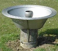
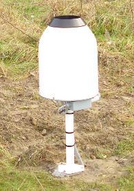
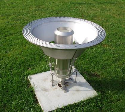
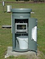
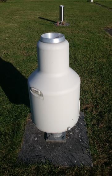
2 Precipitation measurements with rain gauges Conférences 28/09/2013 2
3 More than 400 rain gauges! Courtesy of Michel Journée Several networks in Belgium: RMI AWS (15), SBGE (16), VMM (43), HIC (19), SPW (92), CLIM/SYNOP RMI/WING/BELGOCONTROL (224)

4 Which area is covered by raingauges in Belgium? 200 cm 2 x 400 = 8 m 2


5 Weather radars : more and more Jabbeke RMI Dual-pol 2012 Zaventem Belgocontrol 1974 Replaced in 2003 Helchteren VMM Dual-pol 2016 Avesnois Météo-France Dual-pol 2005 X-band Local Radars Farys-KUL Wideumont RMI 2001

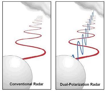
6 Jabbeke and Helchteren dual-pol radars

7 Weather radars : excellent coverage of Belgium
8 Weather radar : measurement principle Typical characteristics of C-band weather radars Frequency/wavelength : 5 GHz/5 cm Pulse repetition frequency (PRF) : Pulse duration : Transmitted power : Beam width: Azimuthal resolution : Range resolution : Max detection range : μs 400 W 1.deg. 1 km at 57 km m km

9 Weather radar : measurement principle Typical characteristics of C-band weather radars Frequency/wavelength : 5 GHz/5 cm Pulse repetition frequency (PRF) : Pulse duration : Transmitted power : Beam width: Azimuthal resolution : Range resolution : Max detection range : μs 400 W 1.deg. 1 km at 57 km m km

10 Scanning strategy Jabbeke and Wideumont radars From 3D data to 2D rainfall product Every 5 minutes 15 elevation angles Top-down From 25 to 0.3 deg. Max range JAB : 300 km WID : 250 km Z R relation 2D image «PCAPPI m»

11 Thunderstorms July 19-20, 2017 LOOP RADAR
")

12 Thunderstorms July 19-20, 2017.Intervention fire and rescue services (SIAMU) Radar-based rainfall amount over Brussels region Source SBGE-IRM/KMI -SIAMU Processing by Brussels Environment Courtesy of Michaël Antoine
13 Radar does not provide direct rainfall measurements From Daniel Michelson (SMHI)
14 Dual-pol based clutter removal Clutter detection using a fuzzy logic algorithm Data types: Non-polarimetric: - Z - Texture of Z - Vert. gradient of Z - V Polarimetric : - Texture of ZDR - Texture of PhiDP - RhoHV Texture = stand. deviation along range
15 Dual-pol based clutter removal Clutter detection using a fuzzy logic algorithm Data types: Non-polarimetric: - Z - Texture of Z - Vert. gradient of Z - V Polarimetric : - Texture of ZDR - Texture of PhiDP - RhoHV Texture = stand. deviation along range
16 From radar observations to rainfall amounts Removal of non-meteorological signals (interferences, ground echoes, planes, birds, ) dual-pol used when available Beam blockage and attenuation correction Stratiform-convective classification Correction based on Vertical Profile of Reflectivity Special treatment for hail Reflectivity (+ dual-pol variables) to rainfall rate Accumulation including advection correction Merging with gauges (Mean fied bias, Kriging with external drift) Combining several radars to make a composite New RMI processing chain and extended verification presented in Goudenhoofdt and Delobbe, J. Hydrometeor., 2016.

17 VPR correction Brigh band case 24h accumuation
 Basic PCAPPI QPE processing")

18 10-years rainfall accumulation ( ) Basic PCAPPI QPE processing including merging with gauges r = 0.54 r = 0.80 Correlation with gauges from independent network
19 Verification 24h accum NO MERGING QPE QPE2 KED
20 Skill What is nowcasting? Detailed description of the current weather along with forecasts obtained by extrapolation for a period of 0 to 6 hours ahead (WMO definition) Radar nowcast Lead time NWP model Radar nowcast = Lagrangian extrapolation of radar rainfall images Lead time NWP : numerical weather prediction model


21 INCA-BE : operational RMI nowcasting system Radars Rain rate Hail High resolution elevation data (USGS GTOPO30) AFD INCA-BE Automatic weather stations, synop stations and regional gauge networks, RMIDB BELLS lightning data NWP (ALARO-4km) 6h update Satellite data (MSG RSS - SAFNWC) From Maarten Reyniers

22 INCA-BE nowcast : June 23, 2016

23 Recent progress in RMI nowcasting systems Recent progress in INCA-BE (Reyniers, ERAD 2014, 2016) Incorporation of hail and lightning Uncertainty plumes added to meteograms, takes into account unknown evolution of motion fields Progress within PLURISK : STEPS-BE Uncertainty information associated with growth and decay of precipitation Weight RAD NWP Improved Radar-NWP blending More in the 2 next talks 2h Lead time 6h
Improvement of quantitative precipitation estimates in Belgium
 Improvement of quantitative precipitation estimates in Belgium L. Delobbe, E. Goudenhoofdt, and B. Mohymont Royal Meteorological Institute of Belgium 1. Introduction In this paper we describe the recent
Long term analysis of convective storm tracks based on C-band radar reflectivity measurements
 Long term analysis of convective storm tracks based on C-band radar reflectivity measurements Edouard Goudenhoofdt, Maarten Reyniers and Laurent Delobbe Royal Meteorological Institute of Belgium, 1180
The opera)onal nowcas)ng system INCA- BE at the Royal Meteorological Ins)tute of Belgium
onal nowcas)ng system INCA- BE at the Royal Meteorological Ins)tute of Belgium") RainGain interna)onal workshop on fine- scale rainfall nowcas)ng Ramada Plaza Hotel, Antwerp, 31-03- 2014 The opera)onal nowcas)ng system INCA- BE at the Royal Meteorological Ins)tute of Belgium dr. Maarten
RainGain interna)onal workshop on fine- scale rainfall nowcas)ng Ramada Plaza Hotel, Antwerp, 31-03- 2014 The opera)onal nowcas)ng system INCA- BE at the Royal Meteorological Ins)tute of Belgium dr. Maarten
Data QC within the Belgian synoptic and climatological networks: an overview
 Data QC within the Belgian synoptic and climatological networks: an overview Cédric Bertrand & Michel Journée (Cedric.Bertrand@meteo.be, Michel.Journee@meteo.be) Royal Meteorological Institute of Belgium
FORECASTING AND MANAGEMENT OF EXTREME RAINFALL PLURISK INDUCED RISKS IN THE URBAN ENVIRONMENT
 FORECASTING AND MANAGEMENT OF EXTREME RAINFALL INDUCED RISKS IN THE URBAN ENVIRONMENT PLURISK WILLEMS P., DE CRUZ L., DELOBBE L., REYNIERS M., VAN OOTEGEM L., MAHY G., LI X., MUÑOZ LOPEZ C., MURLA TUYLS
Development and verification of a real-time stochastic precipitation nowcasting system for urban hydrology in Belgium
 doi:10.5194/hess-20-505-2016 Author(s) 2016. CC Attribution 3.0 License. Development and verification of a real-time stochastic precipitation nowcasting system for urban hydrology in Belgium L. Foresti
Flood Forecasting with Radar
 Flood Forecasting with Radar Miguel Angel Rico-Ramirez m.a.rico-ramirez@bristol.ac.uk Encuentro Internacional de Manejo del Riesgo por Inundaciones, UNAM, 22 th Jan 2013 Talk Outline Rainfall estimation
Aurora Bell*, Alan Seed, Ross Bunn, Bureau of Meteorology, Melbourne, Australia
 15B.1 RADAR RAINFALL ESTIMATES AND NOWCASTS: THE CHALLENGING ROAD FROM RESEARCH TO WARNINGS Aurora Bell*, Alan Seed, Ross Bunn, Bureau of Meteorology, Melbourne, Australia 1. Introduction Warnings are
STEPS-BE: an ensemble radar rainfall nowcasting system for urban hydrology in Belgium
 STEPS-BE: an ensemble radar rainfall nowcasting system for urban hydrology in Belgium Loris Foresti 1,2, Maarten Reyniers 2, Lesley De Cruz 2, Alan Seed 3 and Laurent Delobbe 2 with contributions from
Figure 5: Comparison between SAFIR warning and radar-based hail detection for the hail event of June 8, 2003.
 SAFIR WARNING : Expected risk Radar-based Probability of Hail 0915 0930 0945 1000 Figure 5: Comparison between SAFIR warning and radar-based hail detection for the hail event of June 8, 2003. Lightning
Warning procedures for extreme events in the Emilia-Romagna Region
 Warning procedures for extreme events in the Emilia-Romagna Region Anna Fornasiero, Miria Celano, Roberta Amorati, Virginia Poli and Pier Paolo Alberoni Arpa Emilia-Romagna Hydro-Meteo-Climate Service,
Radar-derived Quantitative Precipitation Estimation Using a Hybrid Rate Estimator Based On Hydrometeor Type
 Radar-derived Quantitative Precipitation Estimation Using a Hybrid Rate Estimator Based On Hydrometeor Type Michael J. Dixon, S. M. Ellis, T. M. Weckwerth and J. W. Wilson National Center for Atmospheric
Radars, Hydrology and Uncertainty
 Radars, Hydrology and Uncertainty Francesca Cecinati University of Bristol, Department of Civil Engineering francesca.cecinati@bristol.ac.uk Supervisor: Miguel A. Rico-Ramirez Research objectives Study
Progress in Operational Quantitative Precipitation Estimation in the Czech Republic
 Progress in Operational Quantitative Precipitation Estimation in the Czech Republic Petr Novák 1 and Hana Kyznarová 1 1 Czech Hydrometeorological Institute,Na Sabatce 17, 143 06 Praha, Czech Republic (Dated:
1. Introduction. 2. The data. P13.15 The effect of a wet radome on dualpol data quality
 P3.5 The effect of a wet radome on dualpol data quality Michael Frech Deutscher Wetterdienst Hohenpeissenberg Meteorological Observatory, Germany. Introduction Operational radar systems typically are equipped
Evaluation of radar-gauge merging methods for quantitative precipitation estimates
 Hydrol. Earth Syst. Sci., 3, 95 3, 9 www.hydrol-earth-syst-sci.net/3/95/9/ Author(s) 9. This work is distributed under the Creative Commons Attribution 3. License. Hydrology and Earth System Sciences Evaluation
On the use of radar rainfall estimates and nowcasts in an operational heavy rainfall warning service
 On the use of radar rainfall estimates and nowcasts in an operational heavy rainfall warning service Alan Seed, Ross Bunn, Aurora Bell Bureau of Meteorology Australia The Centre for Australian Weather
Leuven case study. International workshop & project meeting Leuven, April 2012
 Leuven case study International workshop & project meeting Leuven, 16-17 April 2012 Johan Van Assel (Aquafin) Laurens Cas Decloedt, Patrick Willems (KU Leuven) Raingain Project meeting 17/04/2012 - Aquafin
Convective Structures in Clear-Air Echoes seen by a Weather Radar
 Convective Structures in Clear-Air Echoes seen by a Weather Radar Martin Hagen Deutsches Zentrum für Luft- und Raumfahrt Oberpfaffenhofen, Germany Weather Radar Weather radar are normally used to locate
TIME EVOLUTION OF A STORM FROM X-POL IN SÃO PAULO: 225 A ZH-ZDR AND TITAN METRICS COMPARISON
 TIME EVOLUTION OF A STORM FROM X-POL IN SÃO PAULO: 225 A ZH-ZDR AND TITAN METRICS COMPARISON * Roberto V Calheiros 1 ; Ana M Gomes 2 ; Maria A Lima 1 ; Carlos F de Angelis 3 ; Jojhy Sakuragi 4 (1) Voluntary
The Radar Quality Control and Quantitative Precipitation Estimation Intercomparison Project. RQQI (pronounced Rickey)
") The Radar Quality Control and Quantitative Precipitation Estimation Intercomparison Project RQQI (pronounced Rickey) Paul Joe and Alan Seed Environment Canada Centre for Australian Weather and Climate
The Radar Quality Control and Quantitative Precipitation Estimation Intercomparison Project RQQI (pronounced Rickey) Paul Joe and Alan Seed Environment Canada Centre for Australian Weather and Climate
0-6 hour Weather Forecast Guidance at The Weather Company. Steven Honey, Joseph Koval, Cathryn Meyer, Peter Neilley The Weather Company
 1 0-6 hour Weather Forecast Guidance at The Weather Company Steven Honey, Joseph Koval, Cathryn Meyer, Peter Neilley The Weather Company TWC Forecasts: Widespread Adoption 2 0-6 Hour Forecast Details 3
QPE and QPF in the Bureau of Meteorology
 QPE and QPF in the Bureau of Meteorology Current and future real-time rainfall products Carlos Velasco (BoM) Alan Seed (BoM) and Luigi Renzullo (CSIRO) OzEWEX 2016, 14-15 December 2016, Canberra Why do
Gridding of precipitation and air temperature observations in Belgium. Michel Journée Royal Meteorological Institute of Belgium (RMI)
") Gridding of precipitation and air temperature observations in Belgium Michel Journée Royal Meteorological Institute of Belgium (RMI) Gridding of meteorological data A variety of hydrologic, ecological,
Gridding of precipitation and air temperature observations in Belgium Michel Journée Royal Meteorological Institute of Belgium (RMI) Gridding of meteorological data A variety of hydrologic, ecological,
an experiment to assess the hydrological value of a portable X-band radar
 ERAD 12 - THE SEVENTH EUROPEAN CONFERENCE ON RADAR IN METEOROLOGY AND HYDROLOGY RAINSCANNER@Barcelona: an experiment to assess the hydrological value of a portable X-band radar Marc Berenguer1, Shinju
Xinhua Liu National Meteorological Center (NMC) of China Meteorological Administration (CMA)
 of China Meteorological Administration (CMA)") The short-time forecasting and nowcasting technology of severe convective weather for aviation meteorological services in China Xinhua Liu National Meteorological Center (NMC) of China Meteorological Administration
The short-time forecasting and nowcasting technology of severe convective weather for aviation meteorological services in China Xinhua Liu National Meteorological Center (NMC) of China Meteorological Administration
118 RECONSTRUCTION OF RADAR RFLECTIVITY IN CLUTTER AREAS
 8 RECONSTRUCTION OF RADAR RFLECTIVITY IN CLUTTER AREAS Shinju Park, Marc Berenguer Centre de Recerca Aplicada en Hidrometeorologia, Universitat Politècnica de Catalunya (BarcelonaTech), Barcelona, Spain..
A ZDR Calibration Check using Hydrometeors in the Ice Phase. Abstract
 A ZDR Calibration Check using Hydrometeors in the Ice Phase Michael J. Dixon, J. C. Hubbert, S. Ellis National Center for Atmospheric Research (NCAR), Boulder, Colorado 23B.5 AMS 38 th Conference on Radar
OPERA: Operational Programme for the Exchange of Weather Radar Information
 OPERA: Operational Programme for the Exchange of Weather Radar Information ALADIN-HIRLAM workshop, Toulouse Maud Martet 26-28 April 2016 OPERA: An EUMETNET Project EUMETNET: EIG of 31 European National
Improved radar QPE with temporal interpolation using an advection scheme
 Improved radar QPE with temporal interpolation using an advection scheme Alrun Jasper-Tönnies 1 and Markus Jessen 1 1 hydro & meteo GmbH & Co, KG, Breite Str. 6-8, 23552 Lübeck, Germany (Dated: 18 July
The development of a Kriging based Gauge and Radar merged product for real-time rainfall accumulation estimation
 The development of a Kriging based Gauge and Radar merged product for real-time rainfall accumulation estimation Sharon Jewell and Katie Norman Met Office, FitzRoy Road, Exeter, UK (Dated: 16th July 2014)
*Corresponding author address: Charles Barrere, Weather Decision Technologies, 1818 W Lindsey St, Norman, OK
 P13R.11 Hydrometeorological Decision Support System for the Lower Colorado River Authority *Charles A. Barrere, Jr. 1, Michael D. Eilts 1, and Beth Clarke 2 1 Weather Decision Technologies, Inc. Norman,
Analysis of Radar Rainfall Estimation Accuracy using Hybrid Surface Rainfall (HSR) Technique
 Technique") Analysis of Radar Rainfall Estimation Accuracy using Hybrid Surface Rainfall (HSR) Technique Hye-Sook Park 1, Min-Ho Lee 1, Mi-Kyung Suk 1, Jae-Won Lee 1 1 Korea Meteorological Administration, Weather
Analysis of Radar Rainfall Estimation Accuracy using Hybrid Surface Rainfall (HSR) Technique Hye-Sook Park 1, Min-Ho Lee 1, Mi-Kyung Suk 1, Jae-Won Lee 1 1 Korea Meteorological Administration, Weather
REQUIREMENTS FOR WEATHER RADAR DATA. Review of the current and likely future hydrological requirements for Weather Radar data
 WORLD METEOROLOGICAL ORGANIZATION COMMISSION FOR BASIC SYSTEMS OPEN PROGRAMME AREA GROUP ON INTEGRATED OBSERVING SYSTEMS WORKSHOP ON RADAR DATA EXCHANGE EXETER, UK, 24-26 APRIL 2013 CBS/OPAG-IOS/WxR_EXCHANGE/2.3
DATA FUSION NOWCASTING AND NWP
 DATA FUSION NOWCASTING AND NWP Brovelli Pascal 1, Ludovic Auger 2, Olivier Dupont 1, Jean-Marc Moisselin 1, Isabelle Bernard-Bouissières 1, Philippe Cau 1, Adrien Anquez 1 1 Météo-France Forecasting Department
Utilization of Dual-pol data
 WMO/ASEAN Training Workshop on Weather Radar Data Quality and Standardization Utilization of Dual-pol data 8 February 2018 Hiroshi Yamauchi Observation Department Japan Meteorological Agency Japan Meteorological
A dual-polarization QPE method based on the NCAR Particle ID algorithm Description and preliminary results
 1 Introduction A dual-polarization QPE method based on the CAR Particle ID algorithm Description and preliminary results Michael J. Dixon 1, J. W. Wilson 1, T. M. Weckwerth 1, D. Albo 1 and E. J. Thompson
 Identification of Predictors for Nowcasting Heavy Rainfall In Taiwan --------------------- Part II: Storm Characteristics and Nowcasting Applications Challenges in Developing Nowcasting Applications for
Wheat disease forecasting using weather radar observations
 Wheat disease forecasting using weather radar observations A. Mahtour 1, M. El Jarroudi 1, L. Delobbe 2, L. Hoffmann 3, H. Maraite 4, B. Tychon 1 1 Université de Liège, B-6700 Arlon, Belgium, amahtour@alumni.ulg.ac.be
P4.2 TOWARDS THE ASSIMILATION OF RADAR REFLECTIVITIES: IMPROVING THE OBSERVATION OPERATOR BY APPLYING BEAM BLOCKAGE INFORMATION
 P4.2 TOWARDS THE ASSIMILATION OF RADAR REFLECTIVITIES: IMPROVING THE OBSERVATION OPERATOR BY APPLYING BEAM BLOCKAGE INFORMATION Günther Haase (1), Joan Bech (2), Eric Wattrelot (3), Uta Gjertsen (4) and
and hydrological applications
 Overview of QPE/QPF techniques and hydrological applications Siriluk Chumchean Department of Civil Engineering Mahanakorn University of Technology Typhoon Committee Roving Seminar 2011, Malaysia (20-23
WP2: Fine-scale rainfall data acquisition and prediction:
 WP1 WP2: Fine-scale rainfall data acquisition and prediction: Objective: develop and implement a system for estimation and forecasting of fine-scale (100m, minutes) rainfall Rainfall estimation: combining
The influence of wind turbines on dualpol radar moments and products
 The influence of wind turbines on dualpol radar moments and products Michael Frech and Jörg Seltmann, Deutscher Wetterdienst Hohenpeissenberg Meteorological Observatory, Germany October 2, 2017 1. Introduction
Synergie PC Updates and Plans. A. Lasserre-Bigorry, B. Benech M-F Voidrot, & R. Giraud
 Synergie PC Updates and Plans A. Lasserre-Bigorry, B. Benech M-F Voidrot, & R. Giraud 1 2 3 4 Introduction Migration to PC-Linux Synergie 4.0 features Perspectives for 2006 ECMWF 10 th Workshop on Meteorological
3D radar reflectivity mosaics based on a variational method
 ERAD 1 - THE SEVENTH EUROPEAN ONFERENE ON RADAR IN METEOROLOGY AND HYDROLOGY 3D radar reflectivity mosaics based on a variational method Jordi Roca-Sancho, Marc erenguer, Daniel Sempere-Torres entre de
Study on the rainfall dependence structure using radar and rain gauge data
 International Workshop Advances in Statistical hydrology, May 23-25 2010, Taormina, Italy Study on the rainfall dependence structure using radar and rain gauge data V. Montesarchio, F. Russo, F. Napolitano
Rain rate retrieval of partially blocked beams from single-polarized weather radar data
 Rain rate retrieval of partially blocked beams from single-polarized weather radar data Stephan Jacobi, Axel Bronstert and Maik Heistermann Institute for Earth and Environmental Sciences, University of
Measurements of a network of mobile radars during the experimental campaign of the HydroRad project
 ERAD 2012 - THE SEVENTH EUROPEAN CONFERENCE ON RADAR IN METEOROLOGY AND HYDROLOGY Measurements of a network of mobile radars during the experimental campaign of the HydroRad project Kalogiros J. 1, Anagnostou
Assimilation of Doppler radar observations for high-resolution numerical weather prediction
 Assimilation of Doppler radar observations for high-resolution numerical weather prediction Susan Rennie, Peter Steinle, Mark Curtis, Yi Xiao, Alan Seed Introduction Numerical Weather Prediction (NWP)
Preliminary assessment of LAWR performance in tropical regions with high intensity convective rainfall
 Preliary assessment of LAWR performance in tropical regions with high intensity convective rainfall Chris Nielsen: DHI Water and Environment (Malaysia), Fanny Dugelay, Universitéde Nice Sophia Antipolis,
Winter and summer weather studies using high resolution radar data
 Winter and summer weather studies using high resolution radar data Tim Böhme 1 1 Deutscher Wetterdienst, Frankfurter Str. 135, 63067 Offenbach am Main, Germany (Dated: 29 August 2014) Tim Böhme 1. Introduction
Uta Gjertsen 1 and Günther Haase 2. Norwegian Meteorological Institute, Oslo, Norway
 4.11 RADAR DATA QUALITY THE CHALLENGE OF BEAM BLOCKAGES AND PROPAGATION CHANGES Uta Gjertsen 1 and Günther Haase 2 1 Norwegian Meteorological Institute, Oslo, Norway 2 Swedish Meteorological and Hydrological
PLURISK project 'Forecasting and management of extreme rainfall induced risks in the urban environment'
 PLURISK project 'Forecasting and management of extreme rainfall induced risks in the urban environment' programme 'Science for a Sustainable Development' 1 st Follow-up Committee Meeting Brussels, 12 October
Chapter 2: Polarimetric Radar
 Chapter 2: Polarimetric Radar 2.1 Polarimetric radar vs. conventional radar Conventional weather radars transmit and receive linear electromagnetic radiation whose electric field is parallel to the local
Convection Nowcasting Products Available at the Army Test and Evaluation Command (ATEC) Ranges
 Ranges") Convection Nowcasting Products Available at the Army Test and Evaluation Command (ATEC) Ranges Cathy Kessinger National Center for Atmospheric Research (NCAR), Boulder, CO with contributions from: Wiebke
Convection Nowcasting Products Available at the Army Test and Evaluation Command (ATEC) Ranges Cathy Kessinger National Center for Atmospheric Research (NCAR), Boulder, CO with contributions from: Wiebke
Nowcasting for New Zealand
 ATMOSPHERIC SCIENCE LETTERS Atmos. Sci. Let. 6: 35 39 (2005) Published online in Wiley InterScience (www.interscience.wiley.com). DOI: 10.1002/asl.88 Nowcasting for New Zealand Warren Gray, 1 * Howard
Nowcasting thunderstorms for aeronautical end-users
 Nowcasting thunderstorms for aeronautical end-users Jean-Marc Moisselin Météo-France, Nowcasting Department co-authors: Céline Jauffret (Météo-France) Overview Introduction SAT RADAR NWP image crédit:
Preliminary result of hail detection using an operational S-band polarimetric radar in Korea
 Preliminary result of hail detection using an operational S-band polarimetric radar in Korea Mi-Young Kang 1, Dong-In Lee 1,2, Cheol-Hwan You 2, and Sol-Ip Heo 3 1 Department of Environmental Atmospheric
HydroClass TM. Separating meteorological and non-meteorological targets in Vaisala radar systems. Laura C. Alku 8th July 2014
 HydroClass TM Separating meteorological and non-meteorological targets in Vaisala radar systems 8th July 2014 HydroClass Software for hydrometeor classification Uses dual polarization observations Utilizes
Road weather forecasts and MDSS in Slovakia
 ID: 0030 Road weather forecasts and MDSS in Slovakia M. Benko Slovak Hydrometeorological Institute (SHMI), Jeséniova 17, 83315 Bratislava, Slovakia Corresponding author s E-mail: martin.benko@shmu.sk ABSTRACT
Measuring In-cloud Turbulence: The NEXRAD Turbulence Detection Algorithm
 Measuring In-cloud Turbulence: The NEXRAD Turbulence Detection Algorithm John K. Williams,, Greg Meymaris,, Jason Craig, Gary Blackburn, Wiebke Deierling,, and Frank McDonough AMS 15 th Conference on Aviation,
Polarimetric rainfall retrieval in a tropical environment: consistency analysis for two C-band radars in the Philippines
 Polarimetric rainfall retrieval in a tropical environment: consistency analysis for two C-band radars in the Philippines Irene Crisologo 1, Maik Heistermann 2, and Gianfranco Vulpiani 3 1 University of
Strategic Radar Enhancement Project (SREP) Forecast Demonstration Project (FDP) The future is here and now
 Forecast Demonstration Project (FDP) The future is here and now") Strategic Radar Enhancement Project (SREP) Forecast Demonstration Project (FDP) The future is here and now Michael Berechree National Manager Aviation Weather Services Australian Bureau of Meteorology
Strategic Radar Enhancement Project (SREP) Forecast Demonstration Project (FDP) The future is here and now Michael Berechree National Manager Aviation Weather Services Australian Bureau of Meteorology
Polarization Diversity for the National Weather Service (NWS), WSR-88D radars
, WSR-88D radars") Polarization Diversity for the National Weather Service (NWS), WSR-88D radars Dusan S. Zrnic National Severe Storm Laboratory Norman, OK 73069, USA In the early eighties the NOAA s National Severe Storms
Polarization Diversity for the National Weather Service (NWS), WSR-88D radars Dusan S. Zrnic National Severe Storm Laboratory Norman, OK 73069, USA In the early eighties the NOAA s National Severe Storms
Merging Rain-Gauge and Radar Data
 Merging Rain-Gauge and Radar Data Dr Sharon Jewell, Obserations R&D, Met Office, FitzRoy Road, Exeter sharon.jewell@metoffice.gov.uk Outline 1. Introduction The Gauge and radar network Interpolation techniques
Seamless nowcasting. Open issues
 Federal Department of Home Affairs FDHA Federal Office of Meteorology and Climatology MeteoSwiss Seamless nowcasting INCA Open issues Pierre Eckert Matteo Buzzi, Marco Sassi, Guido della Bruna, Marco Gaia
Validation of Hydrometeor Classification Method for X-band Polarimetric Radars using In Situ Observational Data of Hydrometeor Videosonde
 Validation of Hydrometeor Classification Method for X-band Polarimetric Radars using In Situ Observational Data of Hydrometeor Videosonde Takeharu Kouketsu 1*, Hiroshi Uyeda 1, Mariko Oue 1, Tadayasu Ohigashi
Monitoring radar derived precipitation data, satellite data
 Monitoring radar derived precipitation data, satellite data Outline Current practices Assessing radar data quality Radar alone Radar vs. radar Radar vs. NWP Radar rainfall vs. raingauges Radar wind Some
Regional Flash Flood Guidance and Early Warning System
 WMO Training for Trainers Workshop on Integrated approach to flash flood and flood risk management 24-28 October 2010 Kathmandu, Nepal Regional Flash Flood Guidance and Early Warning System Dr. W. E. Grabs
Comparison of polarimetric techniques for precipitation estimation in Serbia
 Comparison of polarimetric techniques for precipitation estimation in Serbia Zoran Vucinic 1 and Julijana Nadj 2 1 Republic Hydrometeorological Service of Serbia, Kneza Viseslava 66, 11030 Belgrade, Serbia
Hands-on Training on Weather Radar QC
 Hands-on Training on Weather Radar QC 7-8th February 2018 Junji HOTTA Office of Observation Systems Operation Observation Department Weather radar Guide map of the workshop Basics and operation of weather
Skill in nowcasting high-impact heavy precipitation events
 Skill in nowcasting high-impact heavy precipitation events Joan Bech 1 and Marc Berenguer 2 1 Departament d'astronomia i Meteorologia,Facultat de Física. Universitat de Barcelona. Marti i Franqués 1, Barcelona
Nowcasting techniques in use for severe weather operation in NMC/CMA
 WWRP NMRWG Buenos Aires Aug 2017 Nowcasting techniques in use for severe weather operation in NMC/CMA Jianjie WANG National Meteorological Center, CMA Cascading Weather Forecasting Process --- different
Application of Radar QPE. Jack McKee December 3, 2014
 Application of Radar QPE Jack McKee December 3, 2014 Topics Context Precipitation Estimation Techniques Study Methodology Preliminary Results Future Work Questions Introduction Accurate precipitation data
Sensor networks and urban pluvial flood modelling in an urban catchment
 Environmental virtual observatories: managing catchments with wellies, sensors and smartphones Sensor networks and urban pluvial flood modelling in an urban catchment 28 th February 2013 Contents 1. Context
Improving real time observation and nowcasting RDT. E de Coning, M Gijben, B Maseko and L van Hemert Nowcasting and Very Short Range Forecasting
 Improving real time observation and nowcasting RDT E de Coning, M Gijben, B Maseko and L van Hemert Nowcasting and Very Short Range Forecasting Introduction Satellite Application Facilities (SAFs) are
Radar Network for Urban Flood and Severe Weather Monitoring
 Radar Network for Urban Flood and Severe Weather Monitoring V. Chandrasekar 1 and Brenda Philips 2 Colorado State University, United States University of Massachusetts, United States And the full DFW team
DISTRIBUTION FUNCTIONS OF RAINFALL ESTIMATES FROM POLARIMETIC MEASUREMENTS AT X-BAND IN TROPICAL BRAZIL
 DISTRIBUTION FUNCTIONS OF RAINFALL ESTIMATES FROM POLARIMETIC MEASUREMENTS AT X-BAND IN TROPICAL BRAZIL Roberto Vicente Calheiros* 1, Maria Andrea Lima* 1, Ana Maria Gomes 1, Paulo Sergio Borges 1 Carlos
Figure 1: Tephigram for radiosonde launched from Bath at 1100 UTC on 15 June 2005 (IOP 1). The CAPE and CIN are shaded dark and light gray,
. The CAPE and CIN are shaded dark and light gray,") Figure 1: Tephigram for radiosonde launched from Bath at 1100 UTC on 1 June 200 (IOP 1). The CAPE and CIN are shaded dark and light gray, respectively; the thin solid line partially bounding these areas
Figure 1: Tephigram for radiosonde launched from Bath at 1100 UTC on 1 June 200 (IOP 1). The CAPE and CIN are shaded dark and light gray, respectively; the thin solid line partially bounding these areas
HEPS. #HEPEX Quebec 2016 UPGRADED METEOROLOGICAL FORCING FOR OPERATIONAL HYDROLOGICAL ENSEMBLE PREDICTIONS: CHALLENGES, RISKS AND CHANCES
 Zappa M, Andres N, Bogner K, Liechti K #HEPEX Quebec 2016 UPGRADED METEOROLOGICAL FORCING FOR OPERATIONAL HYDROLOGICAL ENSEMBLE PREDICTIONS: CHALLENGES, RISKS AND CHANCES HEPS Contact: massimiliano.zappa@wsl.ch
DETECTION AND FORECASTING - THE CZECH EXPERIENCE
 1 STORM RAINFALL DETECTION AND FORECASTING - THE CZECH EXPERIENCE J. Danhelka * Czech Hydrometeorological Institute, Prague, Czech Republic Abstract Contribution presents the state of the art of operational
Estimation of high spatial resolution precipitation fields using merged rain gauge - radar data. Antonio Manuel Moreno Ródenas
 Estimation of high spatial resolution precipitation fields using merged rain gauge - radar data. 0- Index 1. 2. Methods 3. Case study 4. Results and discussion 5. Conclusions. 1.- 1.- Fuentes Methods de
Meteorology 311. RADAR Fall 2016
 Meteorology 311 RADAR Fall 2016 What is it? RADAR RAdio Detection And Ranging Transmits electromagnetic pulses toward target. Tranmission rate is around 100 s pulses per second (318-1304 Hz). Short silent
EVALUATION OF SATELLITE-DERIVED HIGH RESOLUTION RAINFALL ESTIMATES OVER EASTERN SÃO PAULO AND PARANÁ,, BRAZIL
 EVALUATION OF SATELLITE-DERIVED HIGH RESOLUTION RAINFALL ESTIMATES OVER EASTERN SÃO PAULO AND PARANÁ,, BRAZIL Augusto J. Pereira Filho 1 Phillip Arkin 2 Joe Turk 3 John E. Janowiak 4 Cesar Beneti 5 Leonardo
Combining Meteosat data and weather radar products to improve the meteorological surveillance and nowcasting
 Combining Meteosat data and weather radar products to improve the meteorological surveillance and nowcasting R. Hernandez (1)(2), S. Gaztelumendi (1)(2), K. Otxoa de Alda (1)(2), I. R. Gelpi (1)(2), J.
Improved rainfall estimates and forecasts for urban hydrological applications
 Improved rainfall estimates and forecasts for urban hydrological applications Innovyze User Days - Drainage and Flooding User Group Wallingford, 20 th June 2013 Contents 1. Context 2. Radar rainfall processing
Data quality in the BALTRAD+ Project
 Data quality in the BALTRAD+ Project Jan Szturc 1, Daniel Michelson 2, Jarmo Koistinen 3, Günther Haase 2, Markus Peura 3, Rashpal Gill 4, Martin B. Sørensen 4, Katarzyna Ośródka 1, Anna Jurczyk 1 1 Institute
Research on Lightning Nowcasting and Warning System and Its Application
 Research on Lightning Nowcasting and Warning System and Its Application Wen Yao Chinese Academy of Meteorological Sciences Beijing, China yaowen@camscma.cn 2016.07 1 CONTENTS 1 2 3 4 Lightning Hazards
Hail nowcast exploiting radar and satellite observations
 Federal Department of Home Affairs FDHA Federal Office of Meteorology and Climatology MeteoSwiss Hail nowcast exploiting radar and satellite observations Ulrich Hamann, Elena Leonarduzzi, Kristopher Bedka,
Hourly Precipitation Estimation through Rain-Gauge and Radar: CombiPrecip
 Federal Department of Home Affairs FDHA Federal Office of Meteorology and Climatology MeteoSwiss Documentation of MeteoSwiss Grid-Data Products Hourly Precipitation Estimation through Rain-Gauge and Radar:
Way Forward in Using Radar Data for Climate Monitoring 28 February 2017
 WORLD METEOROLOGICAL ORGANIZATION INTERGOVERNMENTAL OCEANOGRAPHIC COMMISSION Way Forward in Using Radar Data for Climate Monitoring 28 February 2017 GCOS-xxx UNITED NATIONS ENVIRONMENT PROGRAMME INTERNATIONAL
Reprint 797. Development of a Thunderstorm. P.W. Li
 Reprint 797 Development of a Thunderstorm Nowcasting System in Support of Air Traffic Management P.W. Li AMS Aviation, Range, Aerospace Meteorology Special Symposium on Weather-Air Traffic Management Integration,
Danish experiences with short term forecasting in urban drainage applications
 Danish experiences with short term forecasting in urban drainage applications RainGain workshop on fine-scale rainfall nowcasting 31 March 214, Antwerp Associate Professor Søren Thorndahl Department of
ECHO CLASSIFICATION AND SPECTRAL PROCESSING FOR THE DISCRIMINATION OF CLUTTER FROM WEATHER
 P4R.6 ECHO CLASSIFICATION AND SPECTRAL PROCESSING FOR THE DISCRIMINATION OF CLUTTER FROM WEATHER Michael Dixon, Cathy Kessinger and John Hubbert National Center for Atmospheric Research*, Boulder, Colorado
Auto-Nowcast System Tom Saxen (July) Huaqing Cai (Aug) National Center for Atmospheric Research
 Huaqing Cai (Aug) National Center for Atmospheric Research") Auto-Nowcast System Tom Saxen (July) Huaqing Cai (Aug) National Center for Atmospheric Research Summer 2006 ATEC Forecaster Conference Photo courtesy of Greg Thompson Overview: Introductory comments on
Auto-Nowcast System Tom Saxen (July) Huaqing Cai (Aug) National Center for Atmospheric Research Summer 2006 ATEC Forecaster Conference Photo courtesy of Greg Thompson Overview: Introductory comments on
A test bed for verification of a methodology to correct the effects of range dependent errors on radar estimates
 A test bed for verification of a methodology to correct the effects of range dependent errors on radar estimates S. Sebastianelli 1, F. Russo 1, F. Napolitano 1, L. Baldini 2 1 Dipartimento di Ingegneria
Utilising Radar and Satellite Based Nowcasting Tools for Aviation Purposes in South Africa. Erik Becker
 Utilising Radar and Satellite Based Nowcasting Tools for Aviation Purposes in South Africa Erik Becker Morné Gijben, Mary-Jane Bopape, Stephanie Landman South African Weather Service: Nowcasting and Very
Testing a Polarimetric Rainfall Algorithm and Comparison with a Dense Network of Rain Gauges.
 Testing a Polarimetric Rainfall Algorithm and Comparison with a Dense Network of Rain Gauges. Alexander Ryzhkov (1,2), Terry Schuur (1,2), Dusan Zrnic (1) 1 National Severe Storms Laboratory, 1313 Halley
Judit Kerényi. OMSZ - Hungarian Meteorological Service, Budapest, Hungary. H-1525 Budapest, P.O.Box 38, Hungary.
 SATELLITE-DERIVED PRECIPITATION ESTIMATIONS DEVELOPED BY THE HYDROLOGY SAF PROJECT CASE STUDIES FOR THE INVESTIGATION OF THEIR ACCURACY AND FEATURES IN HUNGARY Judit Kerényi OMSZ - Hungarian Meteorological
Fundamentals of Radar Display. Atmospheric Instrumentation
 Fundamentals of Radar Display Outline Fundamentals of Radar Display Scanning Strategies Basic Geometric Varieties WSR-88D Volume Coverage Patterns Classic Radar Displays and Signatures Precipitation Non-weather