Improved rainfall estimates and forecasts for urban hydrological applications
|
|
|
- Christal Eaton
- 5 years ago
- Views:
Transcription
1 Improved rainfall estimates and forecasts for urban hydrological applications Innovyze User Days - Drainage and Flooding User Group Wallingford, 20 th June 2013
2 Contents 1. Context 2. Radar rainfall processing techniques 3. Improved rainfall monitoring in urban areas 4. Conclusions and outlook
3 1. CONTEXT The RainGain Project Why improving rainfall estimates?


4 THE RAINGAIN PROJECT Advanced observation and rainfall prediction for urban pluvial flood management (Sep 2011 Jul 2015) Objective: to improve fine-scale measurement and prediction of rainfall and to enhance urban pluvial flood prediction in order to enable urban water managers to adequately cope with intense storms, so that the vulnerability of populations and critical infrastructure can be reduced.
 8) Seine-St.")
5 Project Partners 1) TU Delft (NL) 2) Zuid-Holland Province (NL) 3) Gemeentewerken Rotterdam (NL) 4) KU Leuven (B) 5) Aquafin NV (B) 6) Ecole des Ponts ParisTech (F) 7) Marne-la-Vallée (F) 8) Seine-St.-Denis (F) 9) Météo France (F) 10) Imperial College London (UK) 11) Met Office (UK) 12) Local Government Flood Forum (UK) 13) Véolia (F)
6 Model Assembly for storm water drainage modelling, forecasting and management Rainfall Estimation / Forecasting Flow Modelling / Forecasting Management (urban planning, RT control, emergency management) S u p p o r t e d b y d a t a (m o n i t o r i n g) The temporal and spatial scales characteristic of urban drainage systems, as well as their complexity, make each of these components more challenging


7 Challenges Rainfall Estimation / Forecasting Flood Modelling / Forecasting Management (urban planning, emergency) The rainfall events which generate pluvial flooding are often associated with thunderstorms of small spatial scale (~ 10 km), whose magnitude and spatial distribution are difficult to monitor and predict Due to the small spatial scale and fast response of urban catchments, rainfall estimates/forecasts with fine spatial and temporal resolution are required
8 Rainfall is the main input for urban pluvial flood models and the uncertainty associated to it dominates the overall uncertainty in the modelling and forecasting of these type of flooding (Golding, 2009) We really need to get the rainfall right!
9 Two essential characteristics of rainfall estimates Accuracy (getting the values right): this is critical! Especially for urban hydrological applications, where errors in rainfall estimates are magnified by the small scale Resolution (spatial & temporal): for urban hydrological applications spatial and temporal resolution must be high
 to urban hydrological")
10 Sensors commonly used for estimation of rainfall at catchment scales Raingauge Weather Radar RAINGAUGE RADAR Accuracy Coverage, spatial characterisation of rainfall field Resolution Further processing of radar rainfall estimates can improve its applicability (in terms of accuracy and resolution) to urban hydrological applications
@beal 23/08/2010 RG event Beal_RG Radar 1km 20 15 Raingauge 10 Collocated radar pixel 5 0")
11 Rain Depth (mm) Why we need to adjust radar rainfall data? 25 Beal HS raingauge Cumulative rainfall Rain Depth depth (23/08/2010 accumulations: 23/08/2010 RG event Beal_RG Radar 1km Raingauge 10 Collocated radar pixel :05 01:05 02:05 03:05 04:05 05:05 06:05 07:05 Time (5 min) Urban drainage models are normally calibrated using raingauge data


12 Tackling the Challenges Rainfall Estimation / Forecasting Flood Modelling / Forecasting Management (urban planning, emergency) Improving accuracy: Gauge-based adjustment of radar rainfall estimates Improving resolution: Rainfall downscaling Improved rainfall monitoring (X-band radar, high quality radar protocols, rain gauge networks) Numerical Weather Prediction: UM/MM5 T = Current T = Future t STATISTICALLY DOWNSCALING i i Temporal Meteorological Radar km C-Band 1-2 km 1 km X-Band m 1 km Spatial CALIBRATION t Ground Raingauge Network

 Purley")

13 These techniques are being tested in 3 pilot locations in the UK Cranbrook (London Borough of Redbridge) Purley (London Borough of Croydon) Torquay City Centre (Torbay, Devon)
 Predominantly urban catchment Sub-catchment of Roding River catchment Subject to")
14 Cranbrook Catchment (LB Redbridge) Area: aprox. 900 ha Cran Brook: 5.75 km (5.69 km culverted) Predominantly urban catchment Sub-catchment of Roding River catchment Subject to fluvial & surface flooding
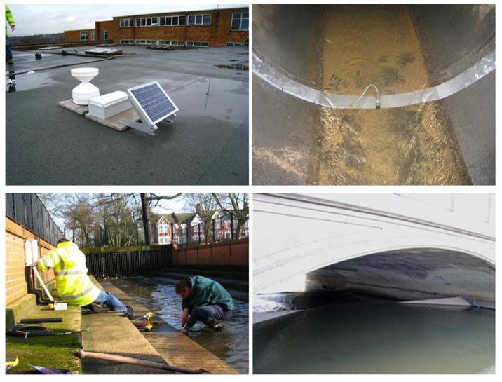

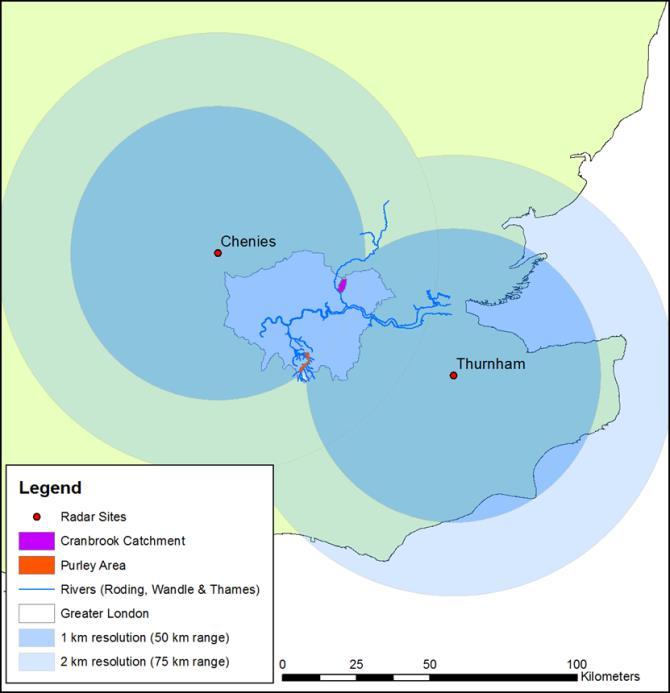
15 Monitoring System Local Sensors Met Office C-band radars
16 2. RAINFALL PROCESSING TECHNIQUES Aimed at improving accuracy and resolution of rainfall estimates Two techniques have been developed and tested: Adjustment of radar rainfall estimates based on raingauge measurements Rainfall spatial downscaling
17 2.1. RADAR-RAINGAUGE MERGING OR ADJUSMENT Aim: To combine the advantages of radar and raingauge sensors to have a better spatial description and local accuracy of urban rainfall Based on their assumption, gauge-based radar rainfall adjustment techniques can be classified into two types Mean Bias Correction Error Variance Minimisation
18 Principle of Bayesian Data Combination RG data Radar data a) b) Block-Kriging interpolation comparison c) d) combination f) e) error field fitted by an exponential variogram In this process the variance of the error is minimised output g) [Image : Ehret et al., 2008] [Source: Todini, 2001]
 (mm) Stratiform Radar@RG total (2) (mm) Radar total (mm) Sample bias B i = (1)/(2)")

19 Four recorded events in the period of over the Cranbrook catchment were studied Convective Event Duration RG total (1) (mm) Stratiform total (2) (mm) Radar total (mm) Sample bias B i = (1)/(2) 23/08/ hr /05/ hr /06/ hr /01/ hr Bias is event-varying, separate adjustment for each event is required
20 Both rainfall profiles and accumulations can be significantly improved through adjustment Rain depth (mm) Rainrate (mm/hr) Mean Rainrate: 23/08/2010 event Bayesian adjusted Mean bias adjusted Raingauge Mean RGs Radar 1km Corrected Radar 1km Bayesian Radar 1km Radar 2 0 0:05 1:05 2:05 3:05 4:05 5:05 6:05 7:05 Time (5min) Mean RGs Radar 1km Corrected Radar 1km Bayesian Radar 1km Mean Rainfall Accummulation: 23/08/2010 event Raingauge Bayesian adjusted Mean bias adjusted Radar 0 0:05 1:05 2:05 3:05 4:05 5:05 6:05 7:05 Time (5 min)
21 Rain (mm/hr) Flow Depth (m) Simulation of flow depths can be largely improved using radar rainfall estimates locally adjusted with the co-located raingauge measurements 23/08/2010 event 0 Pipe (Mid-stream) RGs Radar 1km Observations Corrected Radar 1km Bayesian Radar 1km Obs (Mid-Stream) August 2010 (Time, GMT)
22 Rain (mm/hr) Flow Depth (m) 0 26/05/2011 event Pipe (Mid-stream) RGs Radar 1km Corrected Radar 1km Bayesian Radar 1km Obs (Mid-stream) May 2011 (Time, GMT)
23 Potential applications of gauge-based locally adjusted radar rainfall estimates Event reconstruction Calibration of urban drainage models underway! Improved calibration with not so dense networks of raingauges (this could lead to cost savings) Improved radar-based nowcasts underway!

24 Preliminary results: Calibration of urban drainage models using gaugebased adjusted radar rainfall estimates Case Study: Beddington Catchment, LB Croydon Model: InfoWorks CS semi-distributed model of the sewer system verified in 2012 Drainage area: 64 km 2 Number of nodes: 10,205 Number of links: 10,500 Pipe length: 708 km Number of subcatchments: 5,185 Mean subcatchment area: 1.2 km 2

 data available at 1 km 5")
25 Rainfall and flow monitoring data for model verification Medium term flow survey data: Carried out by TW between 28/01/11 and 13/07/11 79 flow gauges 18 rain gauges 2 min resolution Nimrod (radar) data available at 1 km 5 min
26 Testing of model for different rainfall inputs: (3 storms were analysed the same used for calibration) 1. Original raingauge data, applied using Thiessen Polygons 2. Original Nimrod (radar) data 3. Merged rainfall data (using Bayesian methodology)
27 Better calibration results could be achieved by using adjusted rainfall inputs, as these can better capture the spatial structure and accuracy of rainfall fields E1 E2 E3 E1 E2 E3 MEAN RELATIVE ERROR PEAK FLOW RATE MEAN RELATIVE ERROR - PEAK FLOW DEPTH RG 30.57% 40.56% 40.40% 90.96% 76.29% 20.79% NIMROD 28.27% 36.96% 53.59% 46.21% 24.76% 26.34% MERGED 24.91% 29.75% 37.51% 32.34% 21.12% 18.93% MEAN R 2 FLOW RATE MEAN R 2 FLOW DEPTH RG NIMROD MERGED Mean Relative Error: Indicator of how well the model captures the magnitude of flow rates and depths The lower, the better R 2 (Coefficient of determination): Indicator of how well the model captures flow rate and depth patterns The higher, the better
28 Radar rainfall estimates for a large area (500 km x 500 km) are required as input for nowcasting model Radar estimates for large area were adjusted using colocated raingauges. 2 adjustement techniques were tested: Kriging with external drift Mean bias correction The Met Office nowcasting model was used to produce rainfall forecast for the different rainfall inputs Preliminary results: Improvement of radar-based rainfall nowcasting and associated urban runoff and flow forecasting through dynamic radar-raingauge rainfall adjustment
29 Rainfall Depth (mm) Rainfall Intensity (mm/h) Rainfall Intensity (mm/h) Adjustments were done at too large scales and no improvements were achieved at the local scale of urban catchments spatial variability needs to be considered! Event 1 ( ): Rainfall Accumulations Local RGs Nimrod KED Bias-adjusted SUB-EVENT 1.1: Rainfall Intensity /07 00:00 16/07 06:00 16/07 12:00 16/07 18:00 Time SUB-EVENT 1.2: Rainfall Intensity /07 12:00 16/07 12:00 17/07 12:00 18/07 12:00 Time /07 09:00 17/07 12:00 17/07 15:00 17/07 18:00 Time

 5 4 3 2 1 0 EVENT 2 0 100 200 300 Lead Time")
30 Correlation Coeff. 1 - Relative Error 1 - Relative Error Adjusted radar rainfall estimates may lose their temporal correlation and may not be suitable for further rainfall nowcasting uses EVENT Lead Time (min) EVENT Lead Time (min) 1 EVENT 2 Nimrod Forecasts Lead Time (min) KED Forecasts
31 2.2. Cascade based spatial downscaling to improve spatial resolution of radar rainfall estimates Level n = 8 km V 8km Scaling analysis Feature curve Log (q-th moment) τ Level n = 4 km w i1 w i3 V 3 4km 4km 4km V 1 V 2 w i2 w i4 V 4 4km q = q1 q = q2 q = q3 q = q4 q = q5 τ(q) q Log (spatial scale) Level n = 2 km Level n = 1 km w i3 w i1 V 13 2km wi2 w i4 2km 2km V 11 V 12 V 14 2km w i1 1km V 123 1km V 124 w i2 w i4 w i3 Rainfall Cascade Generator τ τ*(q) τ(q) q V 121 1km V 122 1km downscaling fitting
32 2.3. Accuracy vs. Resolution Analysis of the relative impact of adjustment and downscaling Water Flow Depth level Us Uadjusted t Uadjusted: Us: difference in water depth estimates resulting from bias correction range of water depth estimates resulting from downscaling

33 Us Uadjusted X 100 > 100: resolution > accuracy < 100: accuracy > resolution scale Upstream Midestream Downstream Mean Max Mean Max Mean Max 1 km m /08/2010 event km m km m km m /05/2011 event km m km m km m /06/2011 event km m km m /01/2012 event 1 km m km m km m
34 In most cases, gauge-based radar rainfall adjustment shows larger impact on the subsequent hydraulic outputs: In general, accuracy is more important than resolution! However, it may be possible that in small areas the impact of fine-scale spatial variability of rainfall is relatively more important than the bias observed in radar estimates. We will continue to study the impact of bias and resolution based on more rainfall events
35 3. IMPROVED RAINFALL MONITORING IN URBAN AREAS Installation of X-band radar in London Testing of X-band radar rainfall estimates is underway
.")

36 Installation of X-band radar in London (April 2013 September 2013) Smaller wavelength makes X band radar more sensitive and able of detecting smaller particles (e.g. drizzle, light snow, cloud formation). Because it is closer to the ground, it may be able to provide better rainfall estimates for London Complements network of C-band radars of Met Office Cheaper than bigger radars

37 Installation of X-band radar in London A website for displaying real time and historical data collected with the X-band radar is under development
38 Future activities with X-band radar Comparison of X-band radar, C-band radar and raingauge rainfall estimates Merging of rainfall estimates from these 3 sources Application of X-band radar rainfall estimates to urban drainage models using InfoWorks ICM Live
39 4. CONCLUSIONS AND OUTLOOK Good quality rainfall estimates are essential for reliably modelling and forecasting the behaviour of urban drainage systems Combining rainfall estimates from multiple sensors allows overcoming current problems associated to poor accuracy of radar estimates and point raingauge rainfall measurements Great potential for improving modelling and forecasting the behaviour of urban drainage systems The potential applications and limitations of these techniques and sensors will continue to be explored
40 Thank you for your attention
Sensor networks and urban pluvial flood modelling in an urban catchment
 Environmental virtual observatories: managing catchments with wellies, sensors and smartphones Sensor networks and urban pluvial flood modelling in an urban catchment 28 th February 2013 Contents 1. Context
Radar-raingauge data combination techniques: A revision and analysis of their suitability for urban hydrology
 9th International Conference on Urban Drainage Modelling Belgrade 2012 Radar-raingauge data combination techniques: A revision and analysis of their suitability for urban hydrology L. Wang, S. Ochoa, N.
Improving the applicability of radar rainfall estimates for urban pluvial flood modelling and forecasting
 Improving the applicability of radar rainfall estimates for urban pluvial flood modelling and forecasting Paper 19 Session 6: Operational Monitoring & Control Susana Ochoa-Rodriguez 1 *, Li-Pen Wang 1,2,
RAINGAIN 2 ND NATIONAL OBSERVERS GROUP (NOG) MEETING, UK. London, 16 th April 2013
 MEETING, UK. London, 16 th April 2013") RAINGAIN 2 ND NATIONAL OBSERVERS GROUP (NOG) MEETING, UK London, 16 th April 2013 THE RAINGAIN PROJECT Advanced observation and rainfall prediction for urban pluvial flood management (Sep 2011 Jul 2015)
RAINGAIN 2 ND NATIONAL OBSERVERS GROUP (NOG) MEETING, UK London, 16 th April 2013 THE RAINGAIN PROJECT Advanced observation and rainfall prediction for urban pluvial flood management (Sep 2011 Jul 2015)
ON THE PROPAGATION OF RAINFALL BIAS AND SPATIAL VARIABILITY THROUGH URBAN PLUVIAL FLOOD MODELLING
 ON THE PROPAGATION OF RAINFALL BIAS AND SPATIAL VARIABILITY THROGH RBAN PLVIAL FLOOD MODELLING by L. Wang (1), C. Onof (2), S. Ochoa (3), N. Simões (4) and Č. Maksimović (5) (1) Department of Civil and
WP2: Fine-scale rainfall data acquisition and prediction:
 WP1 WP2: Fine-scale rainfall data acquisition and prediction: Objective: develop and implement a system for estimation and forecasting of fine-scale (100m, minutes) rainfall Rainfall estimation: combining
Radar-based pluvial flood forecasting over urban areas: Redbridge case study
 Weather Radar and Hydrology (Proceedings of a symposium held in Exeter, UK, April 2) (IAHS Publ. 3XX, 2). Radar-based pluvial flood forecasting over urban areas: Redbridge case study L. WANG, N. SIMÕES,
High Resolution Radar Rainfall for Urban Pluvial Flood Control Lessons Learnt From Ten Pilots in North-West Europe Within the RainGain Project
 High Resolution Radar Rainfall for Urban Pluvial Flood Control Lessons Learnt From Ten Pilots in North-West Europe Within the RainGain Project Marie-claire TEN VELDHUIS 1*, Susana OCHOA-RODRIGUEZ 2, Guenda
High resolution radar rainfall for urban pluvial flood management: Lessons learnt from 10 pilots in North-West Europe within the RainGain project
 High resolution radar rainfall for urban pluvial flood management: Lessons learnt from 10 pilots in North-West Europe within the RainGain project Marie-claire TEN VELDHUIS 1*, Susana OCHOA-RODRIGUEZ 2,
Uncertainty in merged radar - rain gauge rainfall products
 Uncertainty in merged radar - rain gauge rainfall products Francesca Cecinati University of Bristol francesca.cecinati@bristol.ac.uk Supervisor: Miguel A. Rico-Ramirez This project has received funding
Weather radar for urban hydrological applications: lessons learnt and research needs identified from 4 pilot catchments in North West Europe
 Weather radar for urban hydrological applications: lessons learnt and research needs identified from 4 pilot catchments in North West Europe J.A.E. ten Veldhuis 1, S. Ochoa Rodriguez 2, G. Bruni 1, A.
PLURISK project 'Forecasting and management of extreme rainfall induced risks in the urban environment'
 PLURISK project 'Forecasting and management of extreme rainfall induced risks in the urban environment' programme 'Science for a Sustainable Development' 1 st Follow-up Committee Meeting Brussels, 12 October
Leuven case study. International workshop & project meeting Leuven, April 2012
 Leuven case study International workshop & project meeting Leuven, 16-17 April 2012 Johan Van Assel (Aquafin) Laurens Cas Decloedt, Patrick Willems (KU Leuven) Raingain Project meeting 17/04/2012 - Aquafin
Impact of small-scale rainfall uncertainty on urban discharge forecasts
 400 Weather Radar and Hydrology (Proceedings of a symposium held in Exeter, UK, April 2011) (IAHS Publ. 351, 2012). Impact of small-scale rainfall uncertainty on urban discharge forecasts A. GIRES 1, D.
Merging Rain-Gauge and Radar Data
 Merging Rain-Gauge and Radar Data Dr Sharon Jewell, Obserations R&D, Met Office, FitzRoy Road, Exeter sharon.jewell@metoffice.gov.uk Outline 1. Introduction The Gauge and radar network Interpolation techniques
Application of Radar QPE. Jack McKee December 3, 2014
 Application of Radar QPE Jack McKee December 3, 2014 Topics Context Precipitation Estimation Techniques Study Methodology Preliminary Results Future Work Questions Introduction Accurate precipitation data
Radars, Hydrology and Uncertainty
 Radars, Hydrology and Uncertainty Francesca Cecinati University of Bristol, Department of Civil Engineering francesca.cecinati@bristol.ac.uk Supervisor: Miguel A. Rico-Ramirez Research objectives Study
REQUIREMENTS FOR WEATHER RADAR DATA. Review of the current and likely future hydrological requirements for Weather Radar data
 WORLD METEOROLOGICAL ORGANIZATION COMMISSION FOR BASIC SYSTEMS OPEN PROGRAMME AREA GROUP ON INTEGRATED OBSERVING SYSTEMS WORKSHOP ON RADAR DATA EXCHANGE EXETER, UK, 24-26 APRIL 2013 CBS/OPAG-IOS/WxR_EXCHANGE/2.3
Evaluation and correction of uncertainty due to Gaussian approximation in radar rain gauge merging using kriging with external drift
 Evaluation and correction of uncertainty due to Gaussian approximation in radar rain gauge merging using kriging with external drift F. Cecinati* 1, O. Wani 2,3, M. A. Rico-Ramirez 1 1 University of Bristol,
Aurora Bell*, Alan Seed, Ross Bunn, Bureau of Meteorology, Melbourne, Australia
 15B.1 RADAR RAINFALL ESTIMATES AND NOWCASTS: THE CHALLENGING ROAD FROM RESEARCH TO WARNINGS Aurora Bell*, Alan Seed, Ross Bunn, Bureau of Meteorology, Melbourne, Australia 1. Introduction Warnings are
QPE and QPF in the Bureau of Meteorology
 QPE and QPF in the Bureau of Meteorology Current and future real-time rainfall products Carlos Velasco (BoM) Alan Seed (BoM) and Luigi Renzullo (CSIRO) OzEWEX 2016, 14-15 December 2016, Canberra Why do
Results of Intensity-Duration- Frequency Analysis for Precipitation and Runoff under Changing Climate
 Results of Intensity-Duration- Frequency Analysis for Precipitation and Runoff under Changing Climate Supporting Casco Bay Region Climate Change Adaptation RRAP Eugene Yan, Alissa Jared, Julia Pierce,
Operational modelling & forecasting in urban catchments. Richard Body Product Sector Leader Operational Forecasting
 Operational modelling & forecasting in urban catchments Richard Body Product Sector Leader Operational Forecasting Contents What is operational forecasting Innovyze software ICMLive components Benefits
Accepted Manuscript. S (15) Reference: HYDROL To appear in: Journal of Hydrology
 Reference: HYDROL To appear in: Journal of Hydrology") Accepted Manuscript Enhancement of radar rainfall estimates for urban hydrology through optical flow temporal interpolation and Bayesian gauge-based adjustment Li-Pen Wang, Susana Ochoa-Rodriguez, Johan
Accepted Manuscript Enhancement of radar rainfall estimates for urban hydrology through optical flow temporal interpolation and Bayesian gauge-based adjustment Li-Pen Wang, Susana Ochoa-Rodriguez, Johan
CIE4491 Lecture. How to quantify stormwater flow urban rainfall data and resolution Marie-claire ten Veldhuis
 CIE4491 Lecture. How to quantify stormwater flow urban rainfall data and resolution Marie-claire ten Veldhuis 18-9-2013 Delft University of Technology Challenge the future Coping with heavy rainfall -
The development of a Kriging based Gauge and Radar merged product for real-time rainfall accumulation estimation
 The development of a Kriging based Gauge and Radar merged product for real-time rainfall accumulation estimation Sharon Jewell and Katie Norman Met Office, FitzRoy Road, Exeter, UK (Dated: 16th July 2014)
Rainfall-runoff modelling using merged rainfall from radar and raingauge measurements
 Rainfall-runoff modelling using merged rainfall from radar and raingauge measurements Nergui Nanding, Miguel Angel Rico-Ramirez and Dawei Han Department of Civil Engineering, University of Bristol Queens
Probabilistic forecasting for urban water management: A case study
 9th International Conference on Urban Drainage Modelling Belgrade 212 Probabilistic forecasting for urban water management: A case study Jeanne-Rose Rene' 1, Henrik Madsen 2, Ole Mark 3 1 DHI, Denmark,
Danish experiences with short term forecasting in urban drainage applications
 Danish experiences with short term forecasting in urban drainage applications RainGain workshop on fine-scale rainfall nowcasting 31 March 214, Antwerp Associate Professor Søren Thorndahl Department of
Merged rainfall fields for continuous simulation modelling (CSM)
") Merged rainfall fields for continuous simulation modelling (CSM) MS Frezghi* and JC Smithers School of Bioresources Engineering and Environmental Hydrology, University of KwaZulu-Natal, Pietermaritzburg,
Merged rainfall fields for continuous simulation modelling (CSM) MS Frezghi* and JC Smithers School of Bioresources Engineering and Environmental Hydrology, University of KwaZulu-Natal, Pietermaritzburg,
Flood Frequency Mapping using Multirun results from Infoworks RS applied to the river basin of the Yser, Belgium
 Flood Frequency Mapping using Multirun results from Infoworks RS applied to the river basin of the Yser, Belgium Ir. Sven Verbeke Aminal, division Water, Flemish Government, Belgium Introduction Aminal
Surface Hydrology Research Group Università degli Studi di Cagliari
 Surface Hydrology Research Group Università degli Studi di Cagliari Evaluation of Input Uncertainty in Nested Flood Forecasts: Coupling a Multifractal Precipitation Downscaling Model and a Fully-Distributed
Richard Body (Innovyze), Ruth Clarke (Innovyze) and William Neale (Thames Water)
, Ruth Clarke (Innovyze) and William Neale (Thames Water)") Real-time Operational Modelling of Sewers: A Case Study Richard Body (Innovyze), Ruth Clarke (Innovyze) and William Neale (Thames Water) Keywords: Operational modelling, forecasting, hydraulic modelling,
Real-time Operational Modelling of Sewers: A Case Study Richard Body (Innovyze), Ruth Clarke (Innovyze) and William Neale (Thames Water) Keywords: Operational modelling, forecasting, hydraulic modelling,
Challenges in providing effective flood forecasts and warnings
 Challenges in providing effective flood forecasts and warnings National Centre for Flood Research Inaugural Symposium Justin Robinson Bureau of Meteorology October 2018 Zero Lives Lost A key responsibility
Progress in Operational Quantitative Precipitation Estimation in the Czech Republic
 Progress in Operational Quantitative Precipitation Estimation in the Czech Republic Petr Novák 1 and Hana Kyznarová 1 1 Czech Hydrometeorological Institute,Na Sabatce 17, 143 06 Praha, Czech Republic (Dated:
Assessing error in hydrological and hydraulic model output flows
 ATMOSPHERIC SCIENCE LETTERS Atmos. Sci. Let. 6: 47 53 (2005) Published online 22 February 2005 in Wiley InterScience (www.interscience.wiley.com). DOI: 10.1002/asl.90 Assessing error in hydrological and
Quantification Of Rainfall Forecast Uncertainty And Its Impact On Flood Forecasting
 City University of New York (CUNY) CUNY Academic Works International Conference on Hydroinformatics 8-1-2014 Quantification Of Rainfall Forecast Uncertainty And Its Impact On Flood Forecasting Niels Van
EFFICIENCY OF THE INTEGRATED RESERVOIR OPERATION FOR FLOOD CONTROL IN THE UPPER TONE RIVER OF JAPAN CONSIDERING SPATIAL DISTRIBUTION OF RAINFALL
 EFFICIENCY OF THE INTEGRATED RESERVOIR OPERATION FOR FLOOD CONTROL IN THE UPPER TONE RIVER OF JAPAN CONSIDERING SPATIAL DISTRIBUTION OF RAINFALL Dawen YANG, Eik Chay LOW and Toshio KOIKE Department of
PRECIPITATION ASSESSMENT FROM THE VIEWPOINT DATA AVAILABILITY FOR PURPOSES OF FLOOD MODELLING
 Proceedings of the 14 th International Conference on Environmental Science and Technology Rhodes, Greece, 3-5 September 2015 PRECIPITATION ASSESSMENT FROM THE VIEWPOINT DATA AVAILABILITY FOR PURPOSES OF
Flash Flood Guidance System On-going Enhancements
 Flash Flood Guidance System On-going Enhancements Hydrologic Research Center, USA Technical Developer SAOFFG Steering Committee Meeting 1 10-12 July 2017 Jakarta, INDONESIA Theresa M. Modrick Hansen, PhD
Stochastic Urban Pluvial Flood Hazard Maps Based upon a Spatial-Temporal Rainfall Generator
 Water 2015, 7, 3396-3406; doi:10.3390/w7073396 Article OPEN ACCESS water ISSN 2073-4441 www.mdpi.com/journal/water Stochastic Urban Pluvial Flood Hazard Maps Based upon a Spatial-Temporal Rainfall Generator
University of Bristol - Explore Bristol Research
 Fadhel, S., Rico-Ramirez, M., & Han, D. (2017). Exploration of an adaptive merging scheme for optimal precipitation estimation over ungauged urban catchment. Journal of Hydroinformatics, 19(2), 225-237.
A real-time procedure for adjusting radar data using raingauge information II: Initial performance of the PMM procedure
 A real-time procedure for adjusting radar data using raingauge information II: Initial performance of the PMM procedure C. G. Collier 1, J. Black 1,2, J. Powell 2, R. Mason 2 l National Centre for Atmospheric
Effect of spatiotemporal variation of rainfall on dissolved oxygen depletion in integrated catchment studies
 8 th International Conference on Sewer Processes and Networks August 31 September 2, 2016, Rotterdam, The Netherlands Effect of spatiotemporal variation of rainfall on dissolved oxygen depletion in integrated
HYDROLOGICAL MODELING APPLICATIONS OF HIGH RESOLUTION RAIN RADAR
 HYDROLOGICAL MODELING APPLICATIONS OF HIGH RESOLUTION RAIN RADAR Luke Sutherland-Stacey, Paul Shucksmith and Geoff Austin Physics Department, University of Auckland ABSTRACT In many hydrological modelling
On the use of radar rainfall estimates and nowcasts in an operational heavy rainfall warning service
 On the use of radar rainfall estimates and nowcasts in an operational heavy rainfall warning service Alan Seed, Ross Bunn, Aurora Bell Bureau of Meteorology Australia The Centre for Australian Weather
Comparison of rainfall distribution method
 Team 6 Comparison of rainfall distribution method In this section different methods of rainfall distribution are compared. METEO-France is the French meteorological agency, a public administrative institution
Minutes of the Second RainGain National Observers Group Meeting (Belgium) Prepared by Johan Van Assel (Aquafin)
 Prepared by Johan Van Assel (Aquafin)") Minutes of the Second RainGain National Observers Group (Belgium) Prepared by Johan Van Assel (Aquafin) Date: Wednesday 15th May 2013, from 9:00 to 14:30 Venue: Aquafin, Delta Building, room Schelde, Dijkstraat
Minutes of the Second RainGain National Observers Group (Belgium) Prepared by Johan Van Assel (Aquafin) Date: Wednesday 15th May 2013, from 9:00 to 14:30 Venue: Aquafin, Delta Building, room Schelde, Dijkstraat
DEVELOPMENT OF A FORECAST EARLY WARNING SYSTEM ethekwini Municipality, Durban, RSA. Clint Chrystal, Natasha Ramdass, Mlondi Hlongwae
 DEVELOPMENT OF A FORECAST EARLY WARNING SYSTEM ethekwini Municipality, Durban, RSA Clint Chrystal, Natasha Ramdass, Mlondi Hlongwae LOCATION DETAILS AND BOUNDARIES ethekwini Municipal Area = 2297 km 2
FORECASTING AND MANAGEMENT OF EXTREME RAINFALL PLURISK INDUCED RISKS IN THE URBAN ENVIRONMENT
 FORECASTING AND MANAGEMENT OF EXTREME RAINFALL INDUCED RISKS IN THE URBAN ENVIRONMENT PLURISK WILLEMS P., DE CRUZ L., DELOBBE L., REYNIERS M., VAN OOTEGEM L., MAHY G., LI X., MUÑOZ LOPEZ C., MURLA TUYLS
Heavier summer downpours with climate change revealed by weather forecast resolution model
 SUPPLEMENTARY INFORMATION DOI: 10.1038/NCLIMATE2258 Heavier summer downpours with climate change revealed by weather forecast resolution model Number of files = 1 File #1 filename: kendon14supp.pdf File
FLORA: FLood estimation and forecast in complex Orographic areas for Risk mitigation in the Alpine space
 Natural Risk Management in a changing climate: Experiences in Adaptation Strategies from some European Projekts Milano - December 14 th, 2011 FLORA: FLood estimation and forecast in complex Orographic
Preliminary assessment of LAWR performance in tropical regions with high intensity convective rainfall
 Preliary assessment of LAWR performance in tropical regions with high intensity convective rainfall Chris Nielsen: DHI Water and Environment (Malaysia), Fanny Dugelay, Universitéde Nice Sophia Antipolis,
Estimation of high spatial resolution precipitation fields using merged rain gauge - radar data. Antonio Manuel Moreno Ródenas
 Estimation of high spatial resolution precipitation fields using merged rain gauge - radar data. 0- Index 1. 2. Methods 3. Case study 4. Results and discussion 5. Conclusions. 1.- 1.- Fuentes Methods de
LIMITS OF RADAR RAINFALL FORECASTING FOR SEWAGE SYSTEM MANAGEMENT : RESULTS AND APPLICATION IN NANCY.
 8th ICUSD, 3 August 999, Sydney/Australia, proceeding Vol., pp. 44-449 LIMITS OF RADAR RAINFALL FORECASTING FOR SEWAGE SYSTEM MANAGEMENT : RESULTS AND APPLICATION IN NANCY. FAURE D.*, SCHMITT J.P.*, AUCHET
Flood Forecasting with Radar
 Flood Forecasting with Radar Miguel Angel Rico-Ramirez m.a.rico-ramirez@bristol.ac.uk Encuentro Internacional de Manejo del Riesgo por Inundaciones, UNAM, 22 th Jan 2013 Talk Outline Rainfall estimation
Challenges from Urban Drainage. Jesper Ellerbæk Nielsen Aalborg University, Denmark Department of Civil Engineering
 Challenges from Urban Drainage Jesper Ellerbæk Nielsen Aalborg University, Denmark Department of Civil Engineering Status for LAWR X-band integration into baltrad Challenges in using baltrad for urban
STUDY ON THE PRECISION OF 1-MINUTE X-BAND MP RADAR RAINFALL DATA IN A SMALL URBAN WATERSHED
 Y. Yonese, et al., Int. J. Sus. Dev. Plann. Vol. 13, No. 4 (2018) 614 625 STUDY ON THE PRECISION OF 1-MINUTE X-BAND MP RADAR RAINFALL DATA IN A SMALL URBAN WATERSHED YOSHITOMO YONESE 1, AKIRA KAWAMURA
The use of rainfall radar in flood warning. Holly Denning Flood Incident Management Team - Wessex
 The use of rainfall radar in flood warning Holly Denning Flood Incident Management Team - Wessex 1 Agenda h Objectives h Crewkerne and Shepton Mallet, Somerset 29 th May 2008 h Ringwood, Dorset 3 rd June
Direction Technique et Performance, Veolia, Paris, France; 5
 1 2 3 4 5 6 7 8 9 10 11 12 13 14 15 16 17 18 19 20 21 22 23 24 25 26 27 28 29 30 31 32 Article Multifractal Comparison of Reflectivity and Polarimetric Rainfall Data from C- and X-Band Radars and Respective
12/07/2017. Flash Flood Warning Service, an advanced approach towards flood resilient cities Floodplain Management Association Conference, Newcastle
 12/07/2017 Worldwide problem: Flash Floods Flash Floods are a Global Problem Flash Flood Warning Service, an advanced approach towards flood resilient cities Floodplain Management Association Conference,
CONTRIBUTION OF ENSEMBLE FORECASTING APPROACHES TO FLASH FLOOD NOWCASTING AT GAUGED AND UNGAUGED CATCHMENTS
 CONTRIBUTION OF ENSEMBLE FORECASTING APPROACHES TO FLASH FLOOD NOWCASTING AT GAUGED AND UNGAUGED CATCHMENTS Maria-Helena Ramos 1, Julie Demargne 2, Pierre Javelle 3 1. Irstea Antony, 2. Hydris Hydrologie,
BALTRAD tailored ender-user product: Risk assessment map for urban drainage management
 BALTRAD tailored ender-user product: Risk assessment map for urban drainage management Authors: Jesper E. Nielsen, Michael R. Rasmussen (AAU) Date: December 2012 BALTRAD Document: BALTRAD+ W4-Risk assessment
Application of Satellite Data for Flood Forecasting and Early Warning in the Mekong River Basin in South-east Asia
 MEKONG RIVER COMMISSION Vientiane, Lao PDR Application of Satellite Data for Flood Forecasting and Early Warning in the Mekong River Basin in South-east Asia 4 th World Water Forum March 2006 Mexico City,
Multifractal study of three storms with different dynamics over the Paris region
 Weather Radar and Hydrology (Proceedings of a symposium held in Exeter, UK, April 2011) (IAHS Publ. 351, 2012). 1 Multifractal study of three storms with different dynamics over the Paris region I. TCHIGUIRINSKAIA
Radar Network for Urban Flood and Severe Weather Monitoring
 Radar Network for Urban Flood and Severe Weather Monitoring V. Chandrasekar 1 and Brenda Philips 2 Colorado State University, United States University of Massachusetts, United States And the full DFW team
Simulation of heavy precipitation events with the COSMO model
 LM User Seminar, 6 March 2007, Langen Federal Department of Home Affairs FDHA Federal Office of Meteorology and Climatology MeteoSwiss Simulation of heavy precipitation events with the COSMO model Silke
and hydrological applications
 Overview of QPE/QPF techniques and hydrological applications Siriluk Chumchean Department of Civil Engineering Mahanakorn University of Technology Typhoon Committee Roving Seminar 2011, Malaysia (20-23
Storm rainfall. Lecture content. 1 Analysis of storm rainfall 2 Predictive model of storm rainfall for a given
 Storm rainfall Lecture content 1 Analysis of storm rainfall 2 Predictive model of storm rainfall for a given max rainfall depth 1 rainfall duration and return period à Depth-Duration-Frequency curves 2
Drought Monitoring with Hydrological Modelling
 st Joint EARS/JRC International Drought Workshop, Ljubljana,.-5. September 009 Drought Monitoring with Hydrological Modelling Stefan Niemeyer IES - Institute for Environment and Sustainability Ispra -
TOWARDS THE USE OF X-BAND DUAL POLARIMETRIC RADAR RAIN- FALL ESTIMATES IN URBAN HYDROLOGY
 TOWARDS THE USE OF X-BAND DUAL POLARIMETRIC RADAR RAIN- FALL ESTIMATES IN URBAN HYDROLOGY by G. Bruni (1), J.A.E. ten Veldhuis (1), T. Otto (2) and H. Leijnse (3) (1) Watermanagement Department, Delft
Flood Forecasting Methodology in Alberta
 Flood Forecasting Methodology in Alberta Evan Friesenhan, M.Eng., P.Eng Alberta Environment and Sustainable Resource Development March 17, 2014 River Forecast Team Mandate To provide Albertans with information
State-space calibration of radar rainfall and stochastic flow forecasting for use in real-time Control of urban drainage systems
 State-space calibration of radar rainfall and stochastic flow forecasting for use in real-time Control of urban drainage systems 9th Int. Conf. On Urban Drainage Modeling Roland Löwe *, Peter Steen Mikkelsen,
The HYDRATE network of hydrometeorological observatories:
 The HYDRATE network of hydrometeorological observatories:. taking stock, looking ahead Marco Borga University of Padova Department of Land and Agroforest Environments marco.borga@unipd.it Outline HYDRATE-NHO:
Terrestrial Flood Risk and Climate Change in the Yallahs River, Jamaica. An assessment of future flood risk. projections of future climate
 Terrestrial Flood Risk and Climate Change in the Yallahs River, Jamaica An assessment of future flood risk using hydrodynamic models driven by projections of future climate Matthew Wilson1, Arpita Mandal2,
PLANNED UPGRADE OF NIWA S HIGH INTENSITY RAINFALL DESIGN SYSTEM (HIRDS)
") PLANNED UPGRADE OF NIWA S HIGH INTENSITY RAINFALL DESIGN SYSTEM (HIRDS) G.A. Horrell, C.P. Pearson National Institute of Water and Atmospheric Research (NIWA), Christchurch, New Zealand ABSTRACT Statistics
PLANNED UPGRADE OF NIWA S HIGH INTENSITY RAINFALL DESIGN SYSTEM (HIRDS) G.A. Horrell, C.P. Pearson National Institute of Water and Atmospheric Research (NIWA), Christchurch, New Zealand ABSTRACT Statistics
Minutes of RainGain Workshop Prepared by Auguste Gires and Rosa Vicari
 Minutes of RainGain Workshop Prepared by Auguste Gires and Rosa Vicari Date: Tuesday Venue: École des Ponts ParisTech (FR) Purpose of the meeting: In-depth scientific and technical discussion Present:
ERA-NET CRUE Funding Initiative. Risk Assessment and Risk Management in Small Urban Catchments
 ERA-NET CRUE Funding Initiative Integrate, Consolidate and Disseminate European Flood Risk Management Research Kick-off Meeting of Research Projects Risk Assessment and Risk Management in Small Urban Catchments
Wales real time forecasting for fast responding rivers. Andy Wall Flood Forecasting Team Leader Environment Agency Wales
 Wales real time forecasting for fast responding rivers Andy Wall Flood Forecasting Team Leader Environment Agency Wales Flood risk & forecasting in Wales Fast responding rivers 220,000 properties at
Improvement of quantitative precipitation estimates in Belgium
 Improvement of quantitative precipitation estimates in Belgium L. Delobbe, E. Goudenhoofdt, and B. Mohymont Royal Meteorological Institute of Belgium 1. Introduction In this paper we describe the recent
Urban SIS D Use case urban flooding: Stockholm
 ECMWF COPERNICUS REPORT Copernicus Climate Change Service Urban SIS D441.6.2.2 Use case urban flooding: Stockholm Issued by: Swedish Meteorological and Hydrological Institute (SMHI) Date: 30/11/2017 Ref:
Quantitative Flood Forecasts using Short-term Radar Nowcasting
 Quantitative Flood Forecasts using Short-term Radar Nowcasting Enrique R. Vivoni *, Dara Entekhabi *, Rafael L. Bras *, Matthew P. Van Horne *, Valeri Y. Ivanov *, Chris Grassotti + and Ross Hoffman +
Solution: The ratio of normal rainfall at station A to normal rainfall at station i or NR A /NR i has been calculated and is given in table below.
 3.6 ESTIMATION OF MISSING DATA Data for the period of missing rainfall data could be filled using estimation technique. The length of period up to which the data could be filled is dependent on individual
Haiti and Dominican Republic Flash Flood Initial Planning Meeting
 Dr Rochelle Graham Climate Scientist Haiti and Dominican Republic Flash Flood Initial Planning Meeting September 7 th to 9 th, 2016 Hydrologic Research Center http://www.hrcwater.org Haiti and Dominican
*Corresponding author address: Charles Barrere, Weather Decision Technologies, 1818 W Lindsey St, Norman, OK
 P13R.11 Hydrometeorological Decision Support System for the Lower Colorado River Authority *Charles A. Barrere, Jr. 1, Michael D. Eilts 1, and Beth Clarke 2 1 Weather Decision Technologies, Inc. Norman,
4 Precipitation. 4.1 Rainfall characteristics
 4 Precipitation 4.1 Rainfall characteristics As rainfall and rainfall properties are the main controlling factors in runoff production, the rainfall characteristics of the study area were carefully studied.
ERAD THE SIXTH EUROPEAN CONFERENCE ON RADAR IN METEOROLOGY AND HYDROLOGY
 Real-time adjustment of radar data for water management systems using a PDF technique: The City RainNet Project Chris. G. Collier 1, Rod Hawnt 2 and John Powell 2 1. National Centre for Atmospheric Science,
The Australian Operational Daily Rain Gauge Analysis
 The Australian Operational Daily Rain Gauge Analysis Beth Ebert and Gary Weymouth Bureau of Meteorology Research Centre, Melbourne, Australia e.ebert@bom.gov.au Daily rainfall data and analysis procedure
ANALYSIS OF CONVECTIVE STRUCTURES USING METEOROLOGICAL RADAR DATA AND SURFACE DATA
 ANALYSIS OF CONVECTIVE STRUCTURES USING METEOROLOGICAL RADAR DATA AND SURFACE DATA Nordila A., Jestin J., 1 Siti Khadijah C.O. 2 Civil Engineering Department, Faculty of Engineering, Universiti Pertahanan
Stochastic disaggregation of spatial-temporal rainfall with limited data
 XXVI General Assembly of the European Geophysical Society Nice, France, 25-3 March 2 Session NP5.3/ Scaling, multifractals and nonlinearity in geophysics: Stochastic rainfall modelling: scaling and other
Influence of rainfall spatial variability on hydrological modelling: case study on two urban catchments
 Influence of rainfall spatial variability on hydrological modelling: case study on two urban catchments Jérôme Schoorens 1, Isabelle Emmanuel 2, Vincent Le Balier 3, Anne Guillon 4 and Bernard Flahaut
Report on the demonstration in Gliwice of enhanced real-time measuring and forecasting technologies for combined sewer systems (D 1.3.
 Report on the demonstration in Gliwice of enhanced real-time measuring and forecasting technologies for combined sewer systems (D 1.3.11) Demonstration Report Report on the demonstration in Gliwice of
Climate change and natural disasters, Athens, Greece October 31, 2018
 Flood early warning systems: operational approaches and challenges Climate change and natural disasters, Athens, Greece October 31, 2018 Athens, October 31, 2018 Marco Borga University of Padova, Italy
An Overview of Operations at the West Gulf River Forecast Center Gregory Waller Service Coordination Hydrologist NWS - West Gulf River Forecast Center
 National Weather Service West Gulf River Forecast Center An Overview of Operations at the West Gulf River Forecast Center Gregory Waller Service Coordination Hydrologist NWS - West Gulf River Forecast
INCA-CE achievements and status
 INCA-CE achievements and status Franziska Strauss Yong Wang Alexander Kann Benedikt Bica Ingo Meirold-Mautner INCA Central Europe Integrated nowcasting for the Central European area This project is implemented
Detailed Storm Rainfall Analysis for Hurricane Ivan Flooding in Georgia Using the Storm Precipitation Analysis System (SPAS) and NEXRAD Weather Radar
 and NEXRAD Weather Radar") Detailed Storm Rainfall Analysis for Hurricane Ivan Flooding in Georgia Using the Storm Precipitation Analysis System (SPAS) and NEXRAD Weather Radar Ed Tomlinson, PhD and Bill Kappel Applied Weather Associates
Detailed Storm Rainfall Analysis for Hurricane Ivan Flooding in Georgia Using the Storm Precipitation Analysis System (SPAS) and NEXRAD Weather Radar Ed Tomlinson, PhD and Bill Kappel Applied Weather Associates
The Nowcasting Demonstration Project for London 2012
 The Nowcasting Demonstration Project for London 2012 Susan Ballard, Zhihong Li, David Simonin, Jean-Francois Caron, Brian Golding, Met Office, UK Introduction The success of convective-scale NWP is largely
Module 1. Lecture 2: Weather and hydrologic cycle (contd.)
") Lecture 2: Weather and hydrologic cycle (contd.) Hydrology Hydor + logos (Both are Greek words) Hydor means water and logos means study. Hydrology is a science which deals with the occurrence, circulation
Lecture 2: Weather and hydrologic cycle (contd.) Hydrology Hydor + logos (Both are Greek words) Hydor means water and logos means study. Hydrology is a science which deals with the occurrence, circulation
UK Flooding Feb 2003
 UK Flooding 2000 06 Feb 2003 Britain has taken a battering from floods in the last 5 years, with major events in 1998 and 2000, significant floods in 2001 and minor events in each of the other years. So
Specialist rainfall scenarios and software package
 Building Knowledge for a Changing Climate Specialist rainfall scenarios and software package Chris Kilsby Ahmad Moaven-Hashemi Hayley Fowler Andrew Smith Aidan Burton Michael Murray University of Newcastle