Uncertainty in merged radar - rain gauge rainfall products
|
|
|
- Alison Scott
- 6 years ago
- Views:
Transcription


1 Uncertainty in merged radar - rain gauge rainfall products Francesca Cecinati University of Bristol francesca.cecinati@bristol.ac.uk Supervisor: Miguel A. Rico-Ramirez This project has received funding from the European Union s Seventh Framework Programme for research, technological development and demonstration under grant agreement no

 Young Graduate")

 Marie Curie")


 Seconded to")
 Seconded to")
2 Who I am Environmental Engineer (M.Sc. Univ. Genova / M.Eng. MIT) Young Graduate Trainee ESA PhD University of Bristol Started November 2014 (2 year) Marie Curie Early Stage Researcher Project: QUICS (Quantifying Uncertainty in Integrated Catchment Studies) Seconded to TU Delft 4 months (2015) Seconded to EAWAG 3 months (summer 2016) Seconded to W+B 2 months (soon)


")
3 Quantifying Uncertainty in Integrated Catchment Studies Rainfall Water Framework Directive (2000/60/EC) Image credits: Melbourne Water

4 PhD topic: rainfall uncertainty Radar Uncertainty Radar Uncertainty Propagation Rain Gauge uncertainty Merged product uncertainty Radar + Rain Gauge merged products Merged Product uncertainty propagation
5 Merging Radar Rain Gauge rainfall products Trying to keep the advantages of both: areal estimates at high spatio-temporal resolution high accuracy Many methods, two main families: Bias corrections Kriging based
6 How to estimate uncertainty Radar: Comparison with rain gauges Modelling source by source Rain gauges: Test studies Theoretical models Merged radar rain gauge : It depends on the method!
7 Kriging with External Drift KED is one of the best and most efficients merging methods The estimate is based on the kriging interpolation of rain gauges The mean of the process is modelled as a linear function of the radar (external drift) The process is assumed to be Gaussian It also estimates the uncertainty associated with the prediction (kriging variance)
8 KED uncertainty modelling 1) Interpolation uncertainty Kriging variance 2) Rain gauge errors Kriging for uncertain data (KUD) 3) Radar residual biases Variation of KED including external drift for SD too 4) Gaussian approximation TransGaussian Kriging, etc
9 KED Z x = m x + Y x m x = a R x + b n Z x 0 = λ i i=1 G x i n i=1 λ i = 1 n j=1 λ i γ ij + μ 1 + μ 2 R x i = γ i0 i = 1,2,, n n λ i i=1 R x i = R x 0
10 1) Kriging variance Z x 0 σ 2 x 0 = W T G = c W T D C = W = C 1 D The kriging variance mainly describes the interpolation uncertainty C 10 C 11 C 1n 1 R 1 C n1 C nn 1 R n R 1 R n 0 0 D = C n0 1 R 0 W = λ 1 λ n μ 1 μ 2
11 KED uncertainty modelling 1) Interpolation uncertainty Kriging variance 2) Rain gauge errors Kriging for uncertain data (KUD) 3) Radar residual biases Variation of KED including external drift for SD too 4) Gaussian approximation TransGaussian Kriging, etc
12 2) Kriging for Uncertain Data (KUD) The nugget effect is a jump in the covariance function that describes the variance at infinitesimal distance C d = c + c 0 d = 0 c exp 3d r d > 0 If the measurement errors are different for the different rain gauges we need a specific c 0i for the i th rain gauge: C = c + c 01 C 1n 1 R 1 C n1 c + c 0n 1 R n R 1 R n 0 0


13 mm/h Findings Predictions 1. Applying KUD to KED usually improves the estimates Variance 2. It is not always true for ordinary kriging mm 2 /h 2 3. KUD has a smoothing effect on the less reliable rain gauges 4. The improvement (or not) is a function of many factors, including the geometry and the characteristics of the rainfall event
14 KED uncertainty modelling 1) Interpolation uncertainty Kriging variance 2) Rain gauge errors Kriging for uncertain data (KUD) 3) Radar residual biases Variation of KED including external drift for SD too 4) Gaussian approximation TransGaussian Kriging, etc
15 3) Radar residual biases The absolute value of radar estimates does not affect the predictions of KED, because a linear function of it is used as trend. If radar bias was spatially homogeneous, it wouldn t affect the KED prediction. Nevertheless, radar uncertainty is not uniform in space, and this needs to be modelled
16 Modification of KED: Regular KED: Z x = m x + Y(x) p m x = α i f i (x) i=1 Radar estimates Modified KED: Z x = m x + σ x ε(x) p m x = α i f i (x) i=1 p σ x = β j g j (x) j=1 Y x zero-mean, second order stationary process ε x zero-mean, unit variance, second order stationary process Elevation Clutter map Bright-band area
17 KED uncertainty modelling 1) Interpolation uncertainty Kriging variance 2) Rain gauge errors Kriging for uncertain data (KUD) 3) Radar residual biases Variation of KED including external drift for SD too 4) Gaussian approximation TransGaussian Kriging, etc
18 4) Gaussian approximations Kriging methods are based on the assumption of secondorder stationary Gaussian processes. Rainfall distribution is not Gaussian, it is skewed, only positive, with a discontinuity in zero. Partial solutions: TransGaussian Kriging Indicator Kriging Disjunctive Kriging Singularity analysis. Controversial Not easily adaptable to KED
19 TransGaussian kriging Rain Gauge data Radar data transformation transformation KED Back transformation (Box-Cox, normal quantiles, etc ) KED merged rainfall estimate Box-Cox Transformations: y = λ = 0.5 Square root λ = 0.25 Square root Square root λ = 0 Logarithm log x if λ = 0 x λ 1 λ if λ 0 Normal quantiles (Normal Scores): empirical transformation


20 Singularity analysis Born in fractal theories, adapted to Bayesian merging by Wang et al. 2015, Imperial College Local Singularities: structures in which the areal average varies with the considered area with a power function They are not fully captured by second-order tools, like the variogram used in kriging, and therefore cannot be maintained in kriging merging, due to the Gaussianity assumption. Radar Rain Gauges Remove singularities KED Recover Singularities Result
21 Evaluation Rain Gauge data Radar data transformation transformation 1 How effective are the transformation methods? How gaussian are the transformed variables? KED Back transformation How well are the results backtransformed? Is the original PDF reproduced? 2 KED merged rainfall estimate What is the quality and the reliability of the final rainfall product? 3 1) Kurtosis 2) Skewness 3) Approx. Negentropy R 2 in QQ-plot regression RG validation: 1) MRTE 2) BIAS 3) Hanssen Kuipers d.
22 1) Gaussianity Test

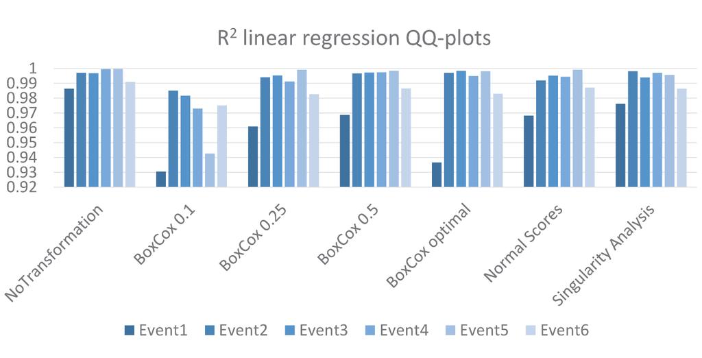
23 2) QQ-plots
24 3) Validation with Rain Gauges Box-Cox with λ = 0.1 introduces a high bias Singularity analysis not suitable for KED Merging usually improves the results Transformations are helpful, but a simple square root does already the job


25 Event on 2009/06/17 20:00 (event 2) Black-border dots: rain gauges used for merging Green-border dots: rain gauges used for validation Notice the radar artefact attenuation

 b ) c ) Integration of rain gauge measurement errors with the overall rainfall")

26 Some work done Representing radar rainfall uncertainty with ensembles based on a time-variant geostatistical error modelling approach Submitted to the Journal of Hydrology, F. Cecinati, M. A. Rico-Ramirez, D. Han, and G. B. M. Heuvelink a ) b ) c ) Integration of rain gauge measurement errors with the overall rainfall uncertainty estimation using kriging methods Presented at EGU 2016 To be submitted soon to a journal Evaluation and correction of uncertainty due to Gaussian approximation in radar rain gauge merging using kriging with external drift Abstract submitted for AGU 2016 To be submitted soon to a journal

27 To conclude Understanding and modelling uncertainty in merged radar-rain gauge products is complex Rain gauge uncertainty: you need to know your gauges. Can you help me with the UK? Radar uncertainty: what spatially variant covariates can affect NIMROD radar uncertainty magnitude? Transformations are good, but advanced methods only introduce instability/approximations What do you think affects KED uncertainty? Thank you!!! This project has received funding from the European Union s Seventh Framework Programme for research, technological development and demonstration under grant agreement no
28 Some references Berndt, C., Rabiei, E. & Haberlandt, U., Geostatistical merging of rain gauge and radar data for high temporal resolutions and various station density scenarios. Journal of Hydrology, 508, pp Clark, I., Statistics or geostatistics? Sampling error or nugget effect? Journal of the Southern African Institute of Mining and Metallurgy, 110(6), pp Mazzetti, C. & Todini, E., Combining Weather Radar and Raingauge Data for Hydrologic Applications. In Flood Risk Management: Research and Practice. London: Taylor & Francis Group Erdin, R., Frei, C. & Künsch, H.R., Data Transformation and Uncertainty in Geostatistical Combination of Radar and Rain Gauges. Journal of Hydrometeorology, 13(1987), pp Wang, L.-P. et al., Singularity-sensitive gauge-based radar rainfall adjustment methods for urban hydrological applications. Hydrology and Earth System Sciences, 19(9), pp
Evaluation and correction of uncertainty due to Gaussian approximation in radar rain gauge merging using kriging with external drift
 Evaluation and correction of uncertainty due to Gaussian approximation in radar rain gauge merging using kriging with external drift F. Cecinati* 1, O. Wani 2,3, M. A. Rico-Ramirez 1 1 University of Bristol,
Representing radar rainfall uncertainty with ensembles based on a time-variant geostatistical error modelling approach
 Representing radar rainfall uncertainty with ensembles based on a time-variant geostatistical error modelling approach Bristol, 4 th March 2016 Francesca Cecinati Background M.Eng. Environmental and Water
Radars, Hydrology and Uncertainty
 Radars, Hydrology and Uncertainty Francesca Cecinati University of Bristol, Department of Civil Engineering francesca.cecinati@bristol.ac.uk Supervisor: Miguel A. Rico-Ramirez Research objectives Study
Comparing two different methods to describe radar precipitation uncertainty
 Comparing two different methods to describe radar precipitation uncertainty Francesca Cecinati, Miguel A. Rico-Ramirez, Dawei Han, University of Bristol, Department of Civil Engineering Corresponding author:
Radar-raingauge data combination techniques: A revision and analysis of their suitability for urban hydrology
 9th International Conference on Urban Drainage Modelling Belgrade 2012 Radar-raingauge data combination techniques: A revision and analysis of their suitability for urban hydrology L. Wang, S. Ochoa, N.
Estimation of high spatial resolution precipitation fields using merged rain gauge - radar data. Antonio Manuel Moreno Ródenas
 Estimation of high spatial resolution precipitation fields using merged rain gauge - radar data. 0- Index 1. 2. Methods 3. Case study 4. Results and discussion 5. Conclusions. 1.- 1.- Fuentes Methods de
Improved rainfall estimates and forecasts for urban hydrological applications
 Improved rainfall estimates and forecasts for urban hydrological applications Innovyze User Days - Drainage and Flooding User Group Wallingford, 20 th June 2013 Contents 1. Context 2. Radar rainfall processing
Influence of parameter estimation uncertainty in Kriging: Part 2 Test and case study applications
 Hydrology and Earth System Influence Sciences, of 5(), parameter 5 3 estimation (1) uncertainty EGS in Kriging: Part Test and case study applications Influence of parameter estimation uncertainty in Kriging:
Gridding of precipitation and air temperature observations in Belgium. Michel Journée Royal Meteorological Institute of Belgium (RMI)
") Gridding of precipitation and air temperature observations in Belgium Michel Journée Royal Meteorological Institute of Belgium (RMI) Gridding of meteorological data A variety of hydrologic, ecological,
Gridding of precipitation and air temperature observations in Belgium Michel Journée Royal Meteorological Institute of Belgium (RMI) Gridding of meteorological data A variety of hydrologic, ecological,
The development of a Kriging based Gauge and Radar merged product for real-time rainfall accumulation estimation
 The development of a Kriging based Gauge and Radar merged product for real-time rainfall accumulation estimation Sharon Jewell and Katie Norman Met Office, FitzRoy Road, Exeter, UK (Dated: 16th July 2014)
Rainfall-runoff modelling using merged rainfall from radar and raingauge measurements
 Rainfall-runoff modelling using merged rainfall from radar and raingauge measurements Nergui Nanding, Miguel Angel Rico-Ramirez and Dawei Han Department of Civil Engineering, University of Bristol Queens
Flood Forecasting with Radar
 Flood Forecasting with Radar Miguel Angel Rico-Ramirez m.a.rico-ramirez@bristol.ac.uk Encuentro Internacional de Manejo del Riesgo por Inundaciones, UNAM, 22 th Jan 2013 Talk Outline Rainfall estimation
Improving the applicability of radar rainfall estimates for urban pluvial flood modelling and forecasting
 Improving the applicability of radar rainfall estimates for urban pluvial flood modelling and forecasting Paper 19 Session 6: Operational Monitoring & Control Susana Ochoa-Rodriguez 1 *, Li-Pen Wang 1,2,
Sub-kilometer-scale space-time stochastic rainfall simulation
 Picture: Huw Alexander Ogilvie Sub-kilometer-scale space-time stochastic rainfall simulation Lionel Benoit (University of Lausanne) Gregoire Mariethoz (University of Lausanne) Denis Allard (INRA Avignon)
Hourly Precipitation Estimation through Rain-Gauge and Radar: CombiPrecip
 Federal Department of Home Affairs FDHA Federal Office of Meteorology and Climatology MeteoSwiss Documentation of MeteoSwiss Grid-Data Products Hourly Precipitation Estimation through Rain-Gauge and Radar:
University of Bristol - Explore Bristol Research
 Fadhel, S., Rico-Ramirez, M., & Han, D. (2017). Exploration of an adaptive merging scheme for optimal precipitation estimation over ungauged urban catchment. Journal of Hydroinformatics, 19(2), 225-237.
Investigation of Monthly Pan Evaporation in Turkey with Geostatistical Technique
 Investigation of Monthly Pan Evaporation in Turkey with Geostatistical Technique Hatice Çitakoğlu 1, Murat Çobaner 1, Tefaruk Haktanir 1, 1 Department of Civil Engineering, Erciyes University, Kayseri,
ON THE PROPAGATION OF RAINFALL BIAS AND SPATIAL VARIABILITY THROUGH URBAN PLUVIAL FLOOD MODELLING
 ON THE PROPAGATION OF RAINFALL BIAS AND SPATIAL VARIABILITY THROGH RBAN PLVIAL FLOOD MODELLING by L. Wang (1), C. Onof (2), S. Ochoa (3), N. Simões (4) and Č. Maksimović (5) (1) Department of Civil and
Concepts and Applications of Kriging. Eric Krause
 Concepts and Applications of Kriging Eric Krause Sessions of note Tuesday ArcGIS Geostatistical Analyst - An Introduction 8:30-9:45 Room 14 A Concepts and Applications of Kriging 10:15-11:30 Room 15 A
Report. Combination of radar and raingauge data for precipitation estimation
 - Unrestricted Report Combination of radar and raingauge data for precipitation estimation Report for the NFR Energy Norway funded project "Utilisation of weather radar data in atmospheric and hydrological
Bayesian Transgaussian Kriging
 1 Bayesian Transgaussian Kriging Hannes Müller Institut für Statistik University of Klagenfurt 9020 Austria Keywords: Kriging, Bayesian statistics AMS: 62H11,60G90 Abstract In geostatistics a widely used
Improvement of quantitative precipitation estimates in Belgium
 Improvement of quantitative precipitation estimates in Belgium L. Delobbe, E. Goudenhoofdt, and B. Mohymont Royal Meteorological Institute of Belgium 1. Introduction In this paper we describe the recent
Effect of spatiotemporal variation of rainfall on dissolved oxygen depletion in integrated catchment studies
 8 th International Conference on Sewer Processes and Networks August 31 September 2, 2016, Rotterdam, The Netherlands Effect of spatiotemporal variation of rainfall on dissolved oxygen depletion in integrated
Weather radar rainfall for hydrological hazard risk management
 Weather radar rainfall for hydrological hazard risk management Dawei Han 韩大卫 Department of Civil Engineering University of Bristol, UK Hydrological hazards related to rainfall Floods Droughts Debris flows
A Framework for Daily Spatio-Temporal Stochastic Weather Simulation
 A Framework for Daily Spatio-Temporal Stochastic Weather Simulation, Rick Katz, Balaji Rajagopalan Geophysical Statistics Project Institute for Mathematics Applied to Geosciences National Center for Atmospheric
Combining radar and rain gauges rainfall estimates using conditional merging: a case study
 Combining radar and rain gauges rainfall estimates using conditional merging: a case study Alberto Pettazzi, Santiago Salsón MeteoGalicia, Galician Weather Service, Xunta de Galicia, C/ Roma 6, 15707 Santiago
Multivariate Geostatistics
 Hans Wackernagel Multivariate Geostatistics An Introduction with Applications Third, completely revised edition with 117 Figures and 7 Tables Springer Contents 1 Introduction A From Statistics to Geostatistics
Merging Rain-Gauge and Radar Data
 Merging Rain-Gauge and Radar Data Dr Sharon Jewell, Obserations R&D, Met Office, FitzRoy Road, Exeter sharon.jewell@metoffice.gov.uk Outline 1. Introduction The Gauge and radar network Interpolation techniques
WP2: Fine-scale rainfall data acquisition and prediction:
 WP1 WP2: Fine-scale rainfall data acquisition and prediction: Objective: develop and implement a system for estimation and forecasting of fine-scale (100m, minutes) rainfall Rainfall estimation: combining
Concepts and Applications of Kriging. Eric Krause Konstantin Krivoruchko
 Concepts and Applications of Kriging Eric Krause Konstantin Krivoruchko Outline Introduction to interpolation Exploratory spatial data analysis (ESDA) Using the Geostatistical Wizard Validating interpolation
118 RECONSTRUCTION OF RADAR RFLECTIVITY IN CLUTTER AREAS
 8 RECONSTRUCTION OF RADAR RFLECTIVITY IN CLUTTER AREAS Shinju Park, Marc Berenguer Centre de Recerca Aplicada en Hidrometeorologia, Universitat Politècnica de Catalunya (BarcelonaTech), Barcelona, Spain..
A Comparison of Rainfall Estimation Techniques
 A Comparison of Rainfall Estimation Techniques Barry F. W. Croke 1,2, Juliet K. Gilmour 2 and Lachlan T. H. Newham 2 SUMMARY: This study compares two techniques that have been developed for rainfall and
Bruno Sansó. Department of Applied Mathematics and Statistics University of California Santa Cruz bruno
 Bruno Sansó Department of Applied Mathematics and Statistics University of California Santa Cruz http://www.ams.ucsc.edu/ bruno Climate Models Climate Models use the equations of motion to simulate changes
Areal rainfall estimation using moving cars computer experiments including hydrological modeling
 Hydrol. Earth Syst. Sci. Discuss., doi:.194/hess-16-17, 16 Areal rainfall estimation using moving cars computer experiments including hydrological modeling Ehsan Rabiei 1, Uwe Haberlandt 1, Monika Sester
Progress in Operational Quantitative Precipitation Estimation in the Czech Republic
 Progress in Operational Quantitative Precipitation Estimation in the Czech Republic Petr Novák 1 and Hana Kyznarová 1 1 Czech Hydrometeorological Institute,Na Sabatce 17, 143 06 Praha, Czech Republic (Dated:
Surface Hydrology Research Group Università degli Studi di Cagliari
 Surface Hydrology Research Group Università degli Studi di Cagliari Evaluation of Input Uncertainty in Nested Flood Forecasts: Coupling a Multifractal Precipitation Downscaling Model and a Fully-Distributed
Geostatistics for Seismic Data Integration in Earth Models
 2003 Distinguished Instructor Short Course Distinguished Instructor Series, No. 6 sponsored by the Society of Exploration Geophysicists European Association of Geoscientists & Engineers SUB Gottingen 7
Comparison of rainfall distribution method
 Team 6 Comparison of rainfall distribution method In this section different methods of rainfall distribution are compared. METEO-France is the French meteorological agency, a public administrative institution
Sensor networks and urban pluvial flood modelling in an urban catchment
 Environmental virtual observatories: managing catchments with wellies, sensors and smartphones Sensor networks and urban pluvial flood modelling in an urban catchment 28 th February 2013 Contents 1. Context
Combining Satellite And Gauge Precipitation Data With Co-Kriging Method For Jakarta Region
 City University of New York (CUNY) CUNY Academic Works International Conference on Hydroinformatics 8-1-214 Combining Satellite And Gauge Precipitation Data With Co-Kriging Method For Jakarta Region Chi
Satellite and gauge rainfall merging using geographically weighted regression
 132 Remote Sensing and GIS for Hydrology and Water Resources (IAHS Publ. 368, 2015) (Proceedings RSHS14 and ICGRHWE14, Guangzhou, China, August 2014). Satellite and gauge rainfall merging using geographically
Probabilistic forecasting for urban water management: A case study
 9th International Conference on Urban Drainage Modelling Belgrade 212 Probabilistic forecasting for urban water management: A case study Jeanne-Rose Rene' 1, Henrik Madsen 2, Ole Mark 3 1 DHI, Denmark,
Stochastic disaggregation of spatial-temporal rainfall with limited data
 XXVI General Assembly of the European Geophysical Society Nice, France, 25-3 March 2 Session NP5.3/ Scaling, multifractals and nonlinearity in geophysics: Stochastic rainfall modelling: scaling and other
Heavier summer downpours with climate change revealed by weather forecast resolution model
 SUPPLEMENTARY INFORMATION DOI: 10.1038/NCLIMATE2258 Heavier summer downpours with climate change revealed by weather forecast resolution model Number of files = 1 File #1 filename: kendon14supp.pdf File
Improved radar QPE with temporal interpolation using an advection scheme
 Improved radar QPE with temporal interpolation using an advection scheme Alrun Jasper-Tönnies 1 and Markus Jessen 1 1 hydro & meteo GmbH & Co, KG, Breite Str. 6-8, 23552 Lübeck, Germany (Dated: 18 July
Multivariate autoregressive modelling and conditional simulation of precipitation time series for urban water models
 European Water 57: 299-306, 2017. 2017 E.W. Publications Multivariate autoregressive modelling and conditional simulation of precipitation time series for urban water models J.A. Torres-Matallana 1,3*,
Lecture 9: Introduction to Kriging
 Lecture 9: Introduction to Kriging Math 586 Beginning remarks Kriging is a commonly used method of interpolation (prediction) for spatial data. The data are a set of observations of some variable(s) of
REQUIREMENTS FOR WEATHER RADAR DATA. Review of the current and likely future hydrological requirements for Weather Radar data
 WORLD METEOROLOGICAL ORGANIZATION COMMISSION FOR BASIC SYSTEMS OPEN PROGRAMME AREA GROUP ON INTEGRATED OBSERVING SYSTEMS WORKSHOP ON RADAR DATA EXCHANGE EXETER, UK, 24-26 APRIL 2013 CBS/OPAG-IOS/WxR_EXCHANGE/2.3
Real-time radar rain-gauge merging using spatio-temporal co-kriging with external drift in the alpine terrain of Switzerland
 Quarterly Journalof the Royal Meteorological Society Q. J. R. Meteorol. Soc. 14: 197 1111, April 214 DOI:1.12/qj.2188 Real-time radar rain-gauge merging using spatio-temporal co-kriging with external drift
Kriging Luc Anselin, All Rights Reserved
 Kriging Luc Anselin Spatial Analysis Laboratory Dept. Agricultural and Consumer Economics University of Illinois, Urbana-Champaign http://sal.agecon.uiuc.edu Outline Principles Kriging Models Spatial Interpolation
AUTOMATIC ESTIMATION OF RAINFALL FIELDS FOR HYDROLOGICAL APPLICATIONS: BLENDING RADAR AND RAIN GAUGE DATA IN REAL TIME
 P13R.12 AUTOMATIC ESTIMATION OF RAINFALL FIELDS FOR HYDROLOGICAL APPLICATIONS: BLENDING RADAR AND RAIN GAUGE DATA IN REAL TIME Carlos Velasco-Forero 1,*, Daniel Sempere-Torres 1, Rafael Sánchez-Diezma
Application of Radar QPE. Jack McKee December 3, 2014
 Application of Radar QPE Jack McKee December 3, 2014 Topics Context Precipitation Estimation Techniques Study Methodology Preliminary Results Future Work Questions Introduction Accurate precipitation data
Areal rainfall estimation using moving cars computer experiments including hydrological modeling
 doi:10.5194/hess-20-3907-2016 Author(s) 2016. CC Attribution 3.0 License. Areal rainfall estimation using moving cars computer experiments including hydrological modeling Ehsan Rabiei 1, Uwe Haberlandt
STATISTICAL MODELS FOR QUANTIFYING THE SPATIAL DISTRIBUTION OF SEASONALLY DERIVED OZONE STANDARDS
 STATISTICAL MODELS FOR QUANTIFYING THE SPATIAL DISTRIBUTION OF SEASONALLY DERIVED OZONE STANDARDS Eric Gilleland Douglas Nychka Geophysical Statistics Project National Center for Atmospheric Research Supported
A STUDY OF MEAN AREAL PRECIPITATION AND SPATIAL STRUCTURE OF RAINFALL DISTRIBUTION IN THE TSEN-WEN RIVER BASIN
 Journal of the Chinese Institute of Engineers, Vol. 24, No. 5, pp. 649-658 (2001) 649 A STUDY OF MEAN AREAL PRECIPITATION AND SPATIAL STRUCTURE OF RAINFALL DISTRIBUTION IN THE TSEN-WEN RIVER BASIN Jet-Chau
7 Geostatistics. Figure 7.1 Focus of geostatistics
 7 Geostatistics 7.1 Introduction Geostatistics is the part of statistics that is concerned with geo-referenced data, i.e. data that are linked to spatial coordinates. To describe the spatial variation
State-space calibration of radar rainfall and stochastic flow forecasting for use in real-time Control of urban drainage systems
 State-space calibration of radar rainfall and stochastic flow forecasting for use in real-time Control of urban drainage systems 9th Int. Conf. On Urban Drainage Modeling Roland Löwe *, Peter Steen Mikkelsen,
HEPS. #HEPEX Quebec 2016 UPGRADED METEOROLOGICAL FORCING FOR OPERATIONAL HYDROLOGICAL ENSEMBLE PREDICTIONS: CHALLENGES, RISKS AND CHANCES
 Zappa M, Andres N, Bogner K, Liechti K #HEPEX Quebec 2016 UPGRADED METEOROLOGICAL FORCING FOR OPERATIONAL HYDROLOGICAL ENSEMBLE PREDICTIONS: CHALLENGES, RISKS AND CHANCES HEPS Contact: massimiliano.zappa@wsl.ch
CIE4491 Lecture. How to quantify stormwater flow urban rainfall data and resolution Marie-claire ten Veldhuis
 CIE4491 Lecture. How to quantify stormwater flow urban rainfall data and resolution Marie-claire ten Veldhuis 18-9-2013 Delft University of Technology Challenge the future Coping with heavy rainfall -
Modeling of Atmospheric Effects on InSAR Measurements With the Method of Stochastic Simulation
 Modeling of Atmospheric Effects on InSAR Measurements With the Method of Stochastic Simulation Z. W. LI, X. L. DING Department of Land Surveying and Geo-Informatics, Hong Kong Polytechnic University, Hung
Quantification Of Rainfall Forecast Uncertainty And Its Impact On Flood Forecasting
 City University of New York (CUNY) CUNY Academic Works International Conference on Hydroinformatics 8-1-2014 Quantification Of Rainfall Forecast Uncertainty And Its Impact On Flood Forecasting Niels Van
Spatio-temporal precipitation modeling based on time-varying regressions
 Spatio-temporal precipitation modeling based on time-varying regressions Oleg Makhnin Department of Mathematics New Mexico Tech Socorro, NM 87801 January 19, 2007 1 Abstract: A time-varying regression
A RADAR-BASED CLIMATOLOGY OF HIGH PRECIPITATION EVENTS IN THE EUROPEAN ALPS:
 2.6 A RADAR-BASED CLIMATOLOGY OF HIGH PRECIPITATION EVENTS IN THE EUROPEAN ALPS: 2000-2007 James V. Rudolph*, K. Friedrich, Department of Atmospheric and Oceanic Sciences, University of Colorado at Boulder,
Bayesian SAE using Complex Survey Data Lecture 4A: Hierarchical Spatial Bayes Modeling
 Bayesian SAE using Complex Survey Data Lecture 4A: Hierarchical Spatial Bayes Modeling Jon Wakefield Departments of Statistics and Biostatistics University of Washington 1 / 37 Lecture Content Motivation
Introduction. Semivariogram Cloud
 Introduction Data: set of n attribute measurements {z(s i ), i = 1,, n}, available at n sample locations {s i, i = 1,, n} Objectives: Slide 1 quantify spatial auto-correlation, or attribute dissimilarity
The Australian Operational Daily Rain Gauge Analysis
 The Australian Operational Daily Rain Gauge Analysis Beth Ebert and Gary Weymouth Bureau of Meteorology Research Centre, Melbourne, Australia e.ebert@bom.gov.au Daily rainfall data and analysis procedure
Gaussian Process Approximations of Stochastic Differential Equations
 Gaussian Process Approximations of Stochastic Differential Equations Cédric Archambeau Centre for Computational Statistics and Machine Learning University College London c.archambeau@cs.ucl.ac.uk CSML
Estimating the long-term health impact of air pollution using spatial ecological studies. Duncan Lee
 Estimating the long-term health impact of air pollution using spatial ecological studies Duncan Lee EPSRC and RSS workshop 12th September 2014 Acknowledgements This is joint work with Alastair Rushworth
ANALYSIS OF DEPTH-AREA-DURATION CURVES OF RAINFALL IN SEMIARID AND ARID REGIONS USING GEOSTATISTICAL METHODS: SIRJAN KAFEH NAMAK WATERSHED, IRAN
 JOURNAL OF ENVIRONMENTAL HYDROLOGY The Electronic Journal of the International Association for Environmental Hydrology On the World Wide Web at http://www.hydroweb.com VOLUME 14 2006 ANALYSIS OF DEPTH-AREA-DURATION
Concepts and Applications of Kriging
 Esri International User Conference San Diego, California Technical Workshops July 24, 2012 Concepts and Applications of Kriging Konstantin Krivoruchko Eric Krause Outline Intro to interpolation Exploratory
Probabilistic temperature post-processing using a skewed response distribution
 Probabilistic temperature post-processing using a skewed response distribution Manuel Gebetsberger 1, Georg J. Mayr 1, Reto Stauffer 2, Achim Zeileis 2 1 Institute of Atmospheric and Cryospheric Sciences,
Statistícal Methods for Spatial Data Analysis
 Texts in Statistícal Science Statistícal Methods for Spatial Data Analysis V- Oliver Schabenberger Carol A. Gotway PCT CHAPMAN & K Contents Preface xv 1 Introduction 1 1.1 The Need for Spatial Analysis
Propagation of Errors in Spatial Analysis
 Stephen F. Austin State University SFA ScholarWorks Faculty Presentations Spatial Science 2001 Propagation of Errors in Spatial Analysis Peter P. Siska I-Kuai Hung Arthur Temple College of Forestry and
Gridded monthly temperature fields for Croatia for the period
 Gridded monthly temperature fields for Croatia for the 1981 2010 period comparison with the similar global and European products Melita Perčec Tadid melita.percec.tadic@cirus.dhz.hr Meteorological and
Is there still room for new developments in geostatistics?
 Is there still room for new developments in geostatistics? Jean-Paul Chilès MINES ParisTech, Fontainebleau, France, IAMG 34th IGC, Brisbane, 8 August 2012 Matheron: books and monographs 1962-1963: Treatise
Acceptable Ergodic Fluctuations and Simulation of Skewed Distributions
 Acceptable Ergodic Fluctuations and Simulation of Skewed Distributions Oy Leuangthong, Jason McLennan and Clayton V. Deutsch Centre for Computational Geostatistics Department of Civil & Environmental Engineering
Results of Intensity-Duration- Frequency Analysis for Precipitation and Runoff under Changing Climate
 Results of Intensity-Duration- Frequency Analysis for Precipitation and Runoff under Changing Climate Supporting Casco Bay Region Climate Change Adaptation RRAP Eugene Yan, Alissa Jared, Julia Pierce,
Storm rainfall. Lecture content. 1 Analysis of storm rainfall 2 Predictive model of storm rainfall for a given
 Storm rainfall Lecture content 1 Analysis of storm rainfall 2 Predictive model of storm rainfall for a given max rainfall depth 1 rainfall duration and return period à Depth-Duration-Frequency curves 2
QPE and QPF in the Bureau of Meteorology
 QPE and QPF in the Bureau of Meteorology Current and future real-time rainfall products Carlos Velasco (BoM) Alan Seed (BoM) and Luigi Renzullo (CSIRO) OzEWEX 2016, 14-15 December 2016, Canberra Why do
Radar precipitation measurement in the Alps big improvements triggered by MAP
 Radar precipitation measurement in the Alps big improvements triggered by MAP Urs Germann, Gianmario Galli, Marco Boscacci MeteoSwiss, Locarno-Monti MeteoSwiss radar Monte Lema, 1625m Can we measure precipitation
Chapter 4 - Fundamentals of spatial processes Lecture notes
 TK4150 - Intro 1 Chapter 4 - Fundamentals of spatial processes Lecture notes Odd Kolbjørnsen and Geir Storvik January 30, 2017 STK4150 - Intro 2 Spatial processes Typically correlation between nearby sites
4th HR-HU and 15th HU geomathematical congress Geomathematics as Geoscience Reliability enhancement of groundwater estimations
 Reliability enhancement of groundwater estimations Zoltán Zsolt Fehér 1,2, János Rakonczai 1, 1 Institute of Geoscience, University of Szeged, H-6722 Szeged, Hungary, 2 e-mail: zzfeher@geo.u-szeged.hu
3. Estimating Dry-Day Probability for Areal Rainfall
 Chapter 3 3. Estimating Dry-Day Probability for Areal Rainfall Contents 3.1. Introduction... 52 3.2. Study Regions and Station Data... 54 3.3. Development of Methodology... 60 3.3.1. Selection of Wet-Day/Dry-Day
Geostatistics in Hydrology: Kriging interpolation
 Chapter Geostatistics in Hydrology: Kriging interpolation Hydrologic properties, such as rainfall, aquifer characteristics (porosity, hydraulic conductivity, transmissivity, storage coefficient, etc.),
Concepts and Applications of Kriging
 2013 Esri International User Conference July 8 12, 2013 San Diego, California Technical Workshop Concepts and Applications of Kriging Eric Krause Konstantin Krivoruchko Outline Intro to interpolation Exploratory
Enabling Climate Information Services for Europe
 Enabling Climate Information Services for Europe Report DELIVERABLE 6.5 Report on past and future stream flow estimates coupled to dam flow evaluation and hydropower production potential Activity: Activity
Basics in Geostatistics 2 Geostatistical interpolation/estimation: Kriging methods. Hans Wackernagel. MINES ParisTech.
 Basics in Geostatistics 2 Geostatistical interpolation/estimation: Kriging methods Hans Wackernagel MINES ParisTech NERSC April 2013 http://hans.wackernagel.free.fr Basic concepts Geostatistics Hans Wackernagel
Kriging method for estimation of groundwater resources in a basin with scarce monitoring data
 36 New Approaches to Hydrological Prediction in Data-sparse Regions (Proc. of Symposium HS. at the Joint IAHS & IAH Convention, Hyderabad, India, September 9). IAHS Publ. 333, 9. Kriging method for estimation
Using linear and non-linear kriging interpolators to produce probability maps
 To be presented at 2001 Annual Conference of the International Association for Mathematical Geology, Cancun, Mexico, September, IAMG2001. Using linear and non-linear kriging interpolators to produce probability
Evaluation of radar-gauge merging methods for quantitative precipitation estimates
 Hydrol. Earth Syst. Sci., 3, 95 3, 9 www.hydrol-earth-syst-sci.net/3/95/9/ Author(s) 9. This work is distributed under the Creative Commons Attribution 3. License. Hydrology and Earth System Sciences Evaluation
Comparison of Interpolation Methods for Precipitation Data in a mountainous Region (Upper Indus Basin-UIB)
") Comparison of Interpolation Methods for Precipitation Data in a mountainous Region (Upper Indus Basin-UIB) AsimJahangir Khan, Doctoral Candidate, Department of Geohydraulicsand Engineering Hydrology, University
Comparison of Interpolation Methods for Precipitation Data in a mountainous Region (Upper Indus Basin-UIB) AsimJahangir Khan, Doctoral Candidate, Department of Geohydraulicsand Engineering Hydrology, University
Index. Geostatistics for Environmental Scientists, 2nd Edition R. Webster and M. A. Oliver 2007 John Wiley & Sons, Ltd. ISBN:
 Index Akaike information criterion (AIC) 105, 290 analysis of variance 35, 44, 127 132 angular transformation 22 anisotropy 59, 99 affine or geometric 59, 100 101 anisotropy ratio 101 exploring and displaying
Combining Rain Gauge and Radar Measurements of a Heavy Precipitation Event over Switzerland
 Veröffentlichung MeteoSchweiz Nr. 81 Combining Rain Gauge and Radar Measurements of a Heavy Precipitation Event over Switzerland Comparison of Geostatistical Methods and Investigation of Important Influencing
ArcGIS for Geostatistical Analyst: An Introduction. Steve Lynch and Eric Krause Redlands, CA.
 ArcGIS for Geostatistical Analyst: An Introduction Steve Lynch and Eric Krause Redlands, CA. Outline - What is geostatistics? - What is Geostatistical Analyst? - Spatial autocorrelation - Geostatistical
Influence of rainfall space-time variability over the Ouémé basin in Benin
 102 Remote Sensing and GIS for Hydrology and Water Resources (IAHS Publ. 368, 2015) (Proceedings RSHS14 and ICGRHWE14, Guangzhou, China, August 2014). Influence of rainfall space-time variability over
PRODUCING PROBABILITY MAPS TO ASSESS RISK OF EXCEEDING CRITICAL THRESHOLD VALUE OF SOIL EC USING GEOSTATISTICAL APPROACH
 PRODUCING PROBABILITY MAPS TO ASSESS RISK OF EXCEEDING CRITICAL THRESHOLD VALUE OF SOIL EC USING GEOSTATISTICAL APPROACH SURESH TRIPATHI Geostatistical Society of India Assumptions and Geostatistical Variogram
Empirical Bayesian Kriging
 Empirical Bayesian Kriging Implemented in ArcGIS Geostatistical Analyst By Konstantin Krivoruchko, Senior Research Associate, Software Development Team, Esri Obtaining reliable environmental measurements
Inflow Forecasting for Hydropower Operations: Bayesian Model Averaging for Postprocessing Hydrological Ensembles
 Inflow Forecasting for Hydropower Operations: Bayesian Model Averaging for Postprocessing Hydrological Ensembles Andreas Kleiven, Ingelin Steinsland Norwegian University of Science & Technology Dept. of
Spatial statistics, addition to Part I. Parameter estimation and kriging for Gaussian random fields
 Spatial statistics, addition to Part I. Parameter estimation and kriging for Gaussian random fields 1 Introduction Jo Eidsvik Department of Mathematical Sciences, NTNU, Norway. (joeid@math.ntnu.no) February
Geostatistics: Kriging
 Geostatistics: Kriging 8.10.2015 Konetekniikka 1, Otakaari 4, 150 10-12 Rangsima Sunila, D.Sc. Background What is Geostatitics Concepts Variogram: experimental, theoretical Anisotropy, Isotropy Lag, Sill,