Concepts and Applications of Kriging. Eric Krause Konstantin Krivoruchko
|
|
|
- Nicholas Mitchell
- 6 years ago
- Views:
Transcription


1 Concepts and Applications of Kriging Eric Krause Konstantin Krivoruchko
2 Outline Introduction to interpolation Exploratory spatial data analysis (ESDA) Using the Geostatistical Wizard Validating interpolation results Empirical Bayesian Kriging Areal Interpolation Questions


3 What is interpolation? Predict values at unknown locations using values at measured locations Many interpolation methods: kriging, IDW, LPI, etc


4 What is autocorrelation? Tobler s first law of geography: "Everything is related to everything else, but near things are more related than distant things."
5 Demo Geostatistical Wizard Eric Krause Esri UC 2014 Technical Workshop Eric Krause, Konstantin Krivoruchko
6 What is kriging? Kriging is the optimal interpolation method if the data meets certain conditions. What are these conditions? - Normally distributed - Stationary - No trends How do I check these conditions? - Exploratory Spatial Data Analysis (ESDA)
7 What is an optimal interpolator? Estimates the true value, on average Lowest expected prediction error Able to use extra information, such as covariates Filters measurement error Can be generalized to polygons (Areal interpolation, Geostatistical simulations) Estimates probability of exceeding a critical threshold
8 Geostatistical workflow 1. Explore the data 2. Choose an interpolation method 3. Fit the interpolation model 4. Validate the results 5. Repeat steps 2-4 as necessary 6. Map the data for decision-making

9 Exploratory Spatial Data Analysis 1. Where is the data located? 2. What are the values of the data points? 3. How does the location of a point relate to its value?
10 Does my data follow a normal distribution? How do I check? 1. Histogram - Check for bell-shaped distribution - Look for outliers 2. Normal QQPlot - Check if data follows 1:1 line What can I do if my data is not normally distributed? - Apply a transformation - Log, Box Cox, Arcsin, Normal Score Transformation

11 Does my data follow a normal distribution? What should I look for? - Bell-shaped - No outliers - Mean Median - Skewness 0 - Kurtosis 3


12 Does my data follow a normal distribution?

13 Normal Score Transformation Fits a smooth curve to the data Performs a quantile transformation to the normal distribution Performs calculations with transformed data, then transforms back at the end Simple kriging with normal score transformation is default in ArcGIS 10.1 and beyond
14 Is my data stationary? What is stationarity? - The statistical relationship between two points depends only on the distance between them. - The variance of the data is constant (after trends have been removed) How do I check for stationarity? - Voronoi Map symbolized by Entropy or Standard Deviation What can I do if my data is nonstationary? - Transformations can stabilize variances - Empirical Bayesian Kriging
15 Is my data stationary? When symbolized by Entropy or StDev, look for randomness in the symbolized Thiessen Polygons.

16 Is my data stationary? When symbolized by Entropy or StDev, look for randomness in the symbolized Thiessen Polygons.

17 Does my data have trends? What are trends? - Trends are systematic changes in the values of the data across the study area. How do I check for trends? - Trend Analysis ESDA tool What can I do if my data has trends? - Use trend removal options - Potential problem Trends are often indistinguishable from autocorrelation and anisotropy - EBK
18 Demo ESDA Eric Krause Esri UC 2014 Technical Workshop Eric Krause, Konstantin Krivoruchko
19 Semivariogram/Covariance Modeling

20 Cross-validation Used to determine the quality of the model - Iteratively discard each sample - Use remaining points to estimate value at measured location - Compare predicted versus measured value

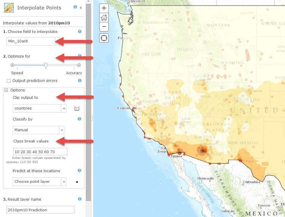
21 Kriging output surface types Prediction Error of Predictions Probability Quantile
22 Demo Kriging Eric Krause Esri UC 2014 Technical Workshop Eric Krause, Konstantin Krivoruchko
23 Empirical Bayesian Kriging Advantages - Requires minimal interactive modeling, spatial relationships are modeled automatically - Usually more accurate, especially for small or nonstationary datasets - Uses local models to capture small scale effects - Doesn t assume one model fits the entire data - Standard errors of prediction are more accurate than other kriging methods Disadvantages - Processing is slower than other kriging methods - Limited customization
24 How does EBK work? 1. Divide the data into subsets of a given size - Controlled by Subset Size parameter - Subsets can overlap, controlled by Overlap Factor 2. For each subset, estimate the semivariogram 3. Simulate data at input point locations and estimate new semivariogram 4. Repeat step 3 many times. This results in a distribution of semivariograms Controlled by Number of Simulations 5. Mix the local surfaces together to get the final surface.
25 What is coming in the future? In ArcGIS Pro 1.2, EBK will support covariate rasters. 1. Will allow EBK to use extra information not contained in the sample points 2. Expands use cases to non-continuous data, such as housing prices and predicted sales revenue.
26 Demo Empirical Bayesian Kriging Eric Krause Esri UC 2014 Technical Workshop Eric Krause, Konstantin Krivoruchko


27 Areal Interpolation Obesity by school zone Obesity surface and error surface Obesity by census block Predict data in a different geometry - School zones to census tracts Estimate values for missing data
28 Types of Areal Interpolation Average (Gaussian) - Median age, average temperature Rate (Binomial) - Cancer rates, obesity rates, percent of college graduates Event (Overdispersed Poisson) - Animal counts, crimes

29 Polygon to Polygon Workflow
30 Demo Areal Interpolation Eric Krause Esri UC 2014 Technical Workshop Eric Krause, Konstantin Krivoruchko

31

32 Available in the bookstore and from Esri Press
33 Sessions of note Tuesday ArcGIS Geostatistical Analyst - An Introduction 8:30-9:45 Room 14 A Concepts and Applications of Kriging 10:15-11:30 Room 14 A Creating Surfaces from Various Data Sources 10:15-11:30 Room 17 B EBK Robust Kriging as a Geoprocessing Tool 3:30-4:15 Exhibit Hall B Wednesday ArcGIS Geostatistical Analyst - An Introduction 1:30-2:45 Room 05 A Concepts and Applications of Kriging 3:15-4:30 Room 05 A Surface Interpolation in ArcGIS 4:30-5:15 Exhibit Hall B Geostat. Simulations - Preparing for Worst Case Scenarios 5:30-6:15 Exhibit Hall B Thursday Polygon-to-Polygon Predictions using Areal Interpolation 9:30-10:15 Exhibit Hall B Creating Surfaces from Various Data Sources 10:15-11:30 Room 17 A ArcGIS Geostatistical Analyst - An Introduction
34
Concepts and Applications of Kriging. Eric Krause
 Concepts and Applications of Kriging Eric Krause Sessions of note Tuesday ArcGIS Geostatistical Analyst - An Introduction 8:30-9:45 Room 14 A Concepts and Applications of Kriging 10:15-11:30 Room 15 A
Concepts and Applications of Kriging
 2013 Esri International User Conference July 8 12, 2013 San Diego, California Technical Workshop Concepts and Applications of Kriging Eric Krause Konstantin Krivoruchko Outline Intro to interpolation Exploratory
Concepts and Applications of Kriging
 Esri International User Conference San Diego, California Technical Workshops July 24, 2012 Concepts and Applications of Kriging Konstantin Krivoruchko Eric Krause Outline Intro to interpolation Exploratory
ArcGIS for Geostatistical Analyst: An Introduction. Steve Lynch and Eric Krause Redlands, CA.
 ArcGIS for Geostatistical Analyst: An Introduction Steve Lynch and Eric Krause Redlands, CA. Outline - What is geostatistics? - What is Geostatistical Analyst? - Spatial autocorrelation - Geostatistical
Geostatistical Interpolation: Kriging and the Fukushima Data. Erik Hoel Colligium Ramazzini October 30, 2011
 Geostatistical Interpolation: Kriging and the Fukushima Data Erik Hoel Colligium Ramazzini October 30, 2011 Agenda Basics of geostatistical interpolation Fukushima radiation Database Web site Geoanalytic
Empirical Bayesian Kriging
 Empirical Bayesian Kriging Implemented in ArcGIS Geostatistical Analyst By Konstantin Krivoruchko, Senior Research Associate, Software Development Team, Esri Obtaining reliable environmental measurements
Lecture 8. Spatial Estimation
 Lecture 8 Spatial Estimation Lecture Outline Spatial Estimation Spatial Interpolation Spatial Prediction Sampling Spatial Interpolation Methods Spatial Prediction Methods Interpolating Raster Surfaces
Report on Kriging in Interpolation
 Tabor Reedy ENVS421 3/12/15 Report on Kriging in Interpolation In this project I explored use of the geostatistical analyst extension and toolbar in the process of creating an interpolated surface through
Lecture 5 Geostatistics
 Lecture 5 Geostatistics Lecture Outline Spatial Estimation Spatial Interpolation Spatial Prediction Sampling Spatial Interpolation Methods Spatial Prediction Methods Interpolating Raster Surfaces with
11/8/2018. Spatial Interpolation & Geostatistics. Kriging Step 1
 (Z i Z j ) 2 / 2 (Z i Zj) 2 / 2 Semivariance y 11/8/2018 Spatial Interpolation & Geostatistics Kriging Step 1 Describe spatial variation with Semivariogram Lag Distance between pairs of points Lag Mean
Spatial Interpolation & Geostatistics
 (Z i Z j ) 2 / 2 Spatial Interpolation & Geostatistics Lag Lag Mean Distance between pairs of points 1 y Kriging Step 1 Describe spatial variation with Semivariogram (Z i Z j ) 2 / 2 Point cloud Map 3
It s a Model. Quantifying uncertainty in elevation models using kriging
 It s a Model Quantifying uncertainty in elevation models using kriging By Konstantin Krivoruchko and Kevin Butler, Esri Raster based digital elevation models (DEM) are the basis of some of the most important
ENGRG Introduction to GIS
 ENGRG 59910 Introduction to GIS Michael Piasecki October 13, 2017 Lecture 06: Spatial Analysis Outline Today Concepts What is spatial interpolation Why is necessary Sample of interpolation (size and pattern)
Integration of Topographic and Bathymetric Digital Elevation Model using ArcGIS. Interpolation Methods: A Case Study of the Klamath River Estuary
 Integration of Topographic and Bathymetric Digital Elevation Model using ArcGIS Interpolation Methods: A Case Study of the Klamath River Estuary by Rachel R. Rodriguez A Thesis Presented to the FACULTY
Luc Anselin Spatial Analysis Laboratory Dept. Agricultural and Consumer Economics University of Illinois, Urbana-Champaign
 GIS and Spatial Analysis Luc Anselin Spatial Analysis Laboratory Dept. Agricultural and Consumer Economics University of Illinois, Urbana-Champaign http://sal.agecon.uiuc.edu Outline GIS and Spatial Analysis
ArcGIS Pro: Analysis and Geoprocessing. Nicholas M. Giner Esri Christopher Gabris Blue Raster
 ArcGIS Pro: Analysis and Geoprocessing Nicholas M. Giner Esri Christopher Gabris Blue Raster Agenda What is Analysis and Geoprocessing? Analysis in ArcGIS Pro - 2D (Spatial xy) - 3D (Elevation - z) - 4D
Spatial Analysis with ArcGIS Pro STUDENT EDITION
 Spatial Analysis with ArcGIS Pro STUDENT EDITION Copyright 2018 Esri All rights reserved. Course version 2.0. Version release date November 2018. Printed in the United States of America. The information
Exploratory Spatial Data Analysis (ESDA)
") Exploratory Spatial Data Analysis (ESDA) VANGHR s method of ESDA follows a typical geospatial framework of selecting variables, exploring spatial patterns, and regression analysis. The primary software
Exploratory Spatial Data Analysis (ESDA) VANGHR s method of ESDA follows a typical geospatial framework of selecting variables, exploring spatial patterns, and regression analysis. The primary software
Texas A&M University. Zachary Department of Civil Engineering. Instructor: Dr. Francisco Olivera. CVEN 658 Civil Engineering Applications of GIS
 1 Texas A&M University Zachary Department of Civil Engineering Instructor: Dr. Francisco Olivera CVEN 658 Civil Engineering Applications of GIS The Use of ArcGIS Geostatistical Analyst Exploratory Spatial
Geostatistical Analyst for Deciding Optimal Interpolation Strategies for Delineating Compact Zones
 International Journal of Geosciences, 2011, 2, 585-596 doi:10.4236/ijg.2011.24061 Published Online November 2011 (http://www.scirp.org/journal/ijg) 585 Geostatistical Analyst for Deciding Optimal Interpolation
Finding Hot Spots in ArcGIS Online: Minimizing the Subjectivity of Visual Analysis. Nicholas M. Giner Esri Parrish S.
 Finding Hot Spots in ArcGIS Online: Minimizing the Subjectivity of Visual Analysis Nicholas M. Giner Esri Parrish S. Henderson FBI Agenda The subjectivity of maps What is Hot Spot Analysis? Why do Hot
Spatial Analysis II. Spatial data analysis Spatial analysis and inference
 Spatial Analysis II Spatial data analysis Spatial analysis and inference Roadmap Spatial Analysis I Outline: What is spatial analysis? Spatial Joins Step 1: Analysis of attributes Step 2: Preparing for
11. Kriging. ACE 492 SA - Spatial Analysis Fall 2003
 11. Kriging ACE 492 SA - Spatial Analysis Fall 2003 c 2003 by Luc Anselin, All Rights Reserved 1 Objectives The goal of this lab is to further familiarize yourself with ESRI s Geostatistical Analyst, extending
GIST 4302/5302: Spatial Analysis and Modeling
 GIST 4302/5302: Spatial Analysis and Modeling Basics of Statistics Guofeng Cao www.myweb.ttu.edu/gucao Department of Geosciences Texas Tech University guofeng.cao@ttu.edu Spring 2015 Outline of This Week
Geog 210C Spring 2011 Lab 6. Geostatistics in ArcMap
 Geog 210C Spring 2011 Lab 6. Geostatistics in ArcMap Overview In this lab you will think critically about the functionality of spatial interpolation, improve your kriging skills, and learn how to use several
Introduction To Raster Based GIS Dr. Zhang GISC 1421 Fall 2016, 10/19
 Introduction To Raster Based GIS Dr. Zhang GISC 1421 Fall 2016, 10/19 Model of the course Using and making maps Navigating GIS maps Map design Working with spatial data Geoprocessing Spatial data infrastructure
GIST 4302/5302: Spatial Analysis and Modeling
 GIST 4302/5302: Spatial Analysis and Modeling Review Guofeng Cao www.gis.ttu.edu/starlab Department of Geosciences Texas Tech University guofeng.cao@ttu.edu Spring 2016 Course Outlines Spatial Point Pattern
Creating Faulted Geologic Surfaces with ArcGIS
 What You Will Need ArcGIS 10.2 for Desktop (Basic, Standard, or Advanced license level) ArcGIS Geostatistical Analyst extension ArcGIS Spatial Analyst extension Sample dataset downloaded from esri.com/arcuser
Spatial analysis. 0 move the objects and the results change
 0 Outline: Roadmap 0 What is spatial analysis? 0 Transformations 0 Introduction to spatial interpolation 0 Classification of spatial interpolation methods 0 Interpolation methods 0 Areal interpolation
Using linear and non-linear kriging interpolators to produce probability maps
 To be presented at 2001 Annual Conference of the International Association for Mathematical Geology, Cancun, Mexico, September, IAMG2001. Using linear and non-linear kriging interpolators to produce probability
ArcGIS 9. ArcGIS Geostatistical Analyst Tutorial
 ArcGIS 9 ArcGIS Geostatistical Analyst Tutorial Copyright 2001, 2003 2006 ESRI All Rights Reserved. Printed in the United States of America. The information contained in this document is the exclusive
Extent of Radiological Contamination in Soil at Four Sites near the Fukushima Daiichi Power Plant, Japan (ArcGIS)
") Extent of Radiological Contamination in Soil at Four Sites near the Fukushima Daiichi Power Plant, Japan (ArcGIS) Contact: Ted Parks, AMEC Foster Wheeler, theodore.parks@amecfw.com, Alex Mikszewski, AMEC
Extent of Radiological Contamination in Soil at Four Sites near the Fukushima Daiichi Power Plant, Japan (ArcGIS) Contact: Ted Parks, AMEC Foster Wheeler, theodore.parks@amecfw.com, Alex Mikszewski, AMEC
Statistícal Methods for Spatial Data Analysis
 Texts in Statistícal Science Statistícal Methods for Spatial Data Analysis V- Oliver Schabenberger Carol A. Gotway PCT CHAPMAN & K Contents Preface xv 1 Introduction 1 1.1 The Need for Spatial Analysis
Interpolating Raster Surfaces
 Interpolating Raster Surfaces You can use interpolation to model the surface of a feature or a phenomenon all you need are sample points, an interpolation method, and an understanding of the feature or
Introduction to ArcGIS Spatial Analyst
 Esri International User Conference San Diego, California Technical Workshops July 2011 Introduction to ArcGIS Spatial Analyst Steve Kopp Elizabeth Graham ArcGIS Spatial Analyst Integrated raster and vector
Geog 469 GIS Workshop. Data Analysis
 Geog 469 GIS Workshop Data Analysis Outline 1. What kinds of need-to-know questions can be addressed using GIS data analysis? 2. What is a typology of GIS operations? 3. What kinds of operations are useful
Unequal Probability-Based Spatial
 Unequal Probability-Based Spatial By Konstantin Krivoruchko and Kevin Butler, Esri Sampling The geographic approach involves measuring the earth, organizing the resultant data, and analyzing it to understand
Sidestepping the box: Designing a supplemental poverty indicator for school neighborhoods
 Sidestepping the box: Designing a supplemental poverty indicator for school neighborhoods Doug Geverdt National Center for Education Statistics Laura Nixon U.S. Census Bureau 2018 Annual meeting of the
ArcGIS 9. ArcGIS Geostatistical Analyst Tutorial
 ArcGIS 9 ArcGIS Geostatistical Analyst Tutorial Copyright 2001, 2003 2008 ESRI All rights reserved. Printed in the United States of America. The information contained in this document is the exclusive
ArcGIS Data Reviewer: Quality Assessment for Elevation Raster Datasets. Roslyn Dunn
 ArcGIS Data Reviewer: Quality Assessment for Elevation Raster Datasets Roslyn Dunn What is ArcGIS Data Reviewer? Data Quality Management for ArcGIS Provides - Rule-based validation - Interactive tools
ArcGIS Geostatistical Analyst: Powerful Exploration and Data Interpolation Solutions
 TM ArcGIS Geostatistical Analyst: Powerful Exploration and Data Interpolation Solutions An ESRI White Paper March 2001 ESRI 380 New York St., Redlands, CA 92373-8100, USA TEL 909-793-2853 FAX 909-793-5953
KAAF- GE_Notes GIS APPLICATIONS LECTURE 3
 GIS APPLICATIONS LECTURE 3 SPATIAL AUTOCORRELATION. First law of geography: everything is related to everything else, but near things are more related than distant things Waldo Tobler Check who is sitting
Outline. Introduction to SpaceStat and ESTDA. ESTDA & SpaceStat. Learning Objectives. Space-Time Intelligence System. Space-Time Intelligence System
 Outline I Data Preparation Introduction to SpaceStat and ESTDA II Introduction to ESTDA and SpaceStat III Introduction to time-dynamic regression ESTDA ESTDA & SpaceStat Learning Objectives Activities
ArcGIS Data Reviewer: Assessing Positional Accuracy. Roslyn Dunn
 ArcGIS Data Reviewer: Assessing Positional Accuracy Roslyn Dunn What is ArcGIS Data Reviewer? Data Quality Management for ArcGIS Provides - Rule-based validation - Interactive tools - Track errors Validate
Types of spatial data. The Nature of Geographic Data. Types of spatial data. Spatial Autocorrelation. Continuous spatial data: geostatistics
 The Nature of Geographic Data Types of spatial data Continuous spatial data: geostatistics Samples may be taken at intervals, but the spatial process is continuous e.g. soil quality Discrete data Irregular:
Umeå University Sara Sjöstedt-de Luna Time series analysis and spatial statistics
 Umeå University 01-05-5 Sara Sjöstedt-de Luna Time series analysis and spatial statistics Laboration in ArcGIS Geostatistical Analyst These exercises are aiming at helping you understand ArcGIS Geostatistical
Spatial Data Analysis in Archaeology Anthropology 589b. Kriging Artifact Density Surfaces in ArcGIS
 Spatial Data Analysis in Archaeology Anthropology 589b Fraser D. Neiman University of Virginia 2.19.07 Spring 2007 Kriging Artifact Density Surfaces in ArcGIS 1. The ingredients. -A data file -- in.dbf
A GEOSTATISTICAL APPROACH TO PREDICTING A PHYSICAL VARIABLE THROUGH A CONTINUOUS SURFACE
 Katherine E. Williams University of Denver GEOG3010 Geogrpahic Information Analysis April 28, 2011 A GEOSTATISTICAL APPROACH TO PREDICTING A PHYSICAL VARIABLE THROUGH A CONTINUOUS SURFACE Overview Data
Migrating Defense Workflows from ArcMap to ArcGIS Pro. Renee Bernstein and Jared Sellers
 Migrating Defense Workflows from ArcMap to ArcGIS Pro Renee Bernstein and Jared Sellers ArcGIS Desktop Desktop Web Device ArcMap ArcCatalog ArcScene ArcGlobe ArcGIS Pro portal Server Online Content and
ArcGIS & Extensions - Synergy of GIS tools. Synergy. Analyze & Visualize
 Using ArcGIS Extensions to Analyze and Visualize data Colin Childs 1 Topics Objectives Synergy Analysis & Visualization ArcGIS Analysis environments Geoprocessing tools Extensions ArcMap The analysis Process
Esri UC2013. Technical Workshop.
 Esri International User Conference San Diego, California Technical Workshops July 9, 2013 CAD: Introduction to using CAD Data in ArcGIS Jeff Reinhart & Phil Sanchez Agenda Overview of ArcGIS CAD Support
Spatial Analysis 1. Introduction
 Spatial Analysis 1 Introduction Geo-referenced Data (not any data) x, y coordinates (e.g., lat., long.) ------------------------------------------------------ - Table of Data: Obs. # x y Variables -------------------------------------
Python Raster Analysis. Kevin M. Johnston Nawajish Noman
 Python Raster Analysis Kevin M. Johnston Nawajish Noman Outline Managing rasters and performing analysis with Map Algebra How to access the analysis capability - Demonstration Complex expressions and optimization
Index. Geostatistics for Environmental Scientists, 2nd Edition R. Webster and M. A. Oliver 2007 John Wiley & Sons, Ltd. ISBN:
 Index Akaike information criterion (AIC) 105, 290 analysis of variance 35, 44, 127 132 angular transformation 22 anisotropy 59, 99 affine or geometric 59, 100 101 anisotropy ratio 101 exploring and displaying
Spatial Analysis and Modeling (GIST 4302/5302) Guofeng Cao Department of Geosciences Texas Tech University
 Guofeng Cao Department of Geosciences Texas Tech University") Spatial Analysis and Modeling (GIST 4302/5302) Guofeng Cao Department of Geosciences Texas Tech University TTU Graduate Certificate Geographic Information Science and Technology (GIST) 3 Core Courses and
Spatial Analysis and Modeling (GIST 4302/5302) Guofeng Cao Department of Geosciences Texas Tech University TTU Graduate Certificate Geographic Information Science and Technology (GIST) 3 Core Courses and
Mapping and Analysis for Spatial Social Science
 Mapping and Analysis for Spatial Social Science Luc Anselin Spatial Analysis Laboratory Dept. Agricultural and Consumer Economics University of Illinois, Urbana-Champaign http://sal.agecon.uiuc.edu Outline
SPATIAL VARIABILITY MAPPING OF N-VALUE OF SOILS OF MUMBAI CITY USING ARCGIS
 SPATIAL VARIABILITY MAPPING OF N-VALUE OF SOILS OF MUMBAI CITY USING ARCGIS RESHMA RASKAR - PHULE 1, KSHITIJA NADGOUDA 2 1 Assistant Professor, Department of Civil Engineering, Sardar Patel College of
PRODUCING PROBABILITY MAPS TO ASSESS RISK OF EXCEEDING CRITICAL THRESHOLD VALUE OF SOIL EC USING GEOSTATISTICAL APPROACH
 PRODUCING PROBABILITY MAPS TO ASSESS RISK OF EXCEEDING CRITICAL THRESHOLD VALUE OF SOIL EC USING GEOSTATISTICAL APPROACH SURESH TRIPATHI Geostatistical Society of India Assumptions and Geostatistical Variogram
Introduction to Spatial Analysis in ArcGIS Online. Jian Lange, Vicki Lynn Cove
 Introduction to Spatial Analysis in ArcGIS Online Jian Lange, Vicki Lynn Cove Topics Introducing ArcGIS Online Spatial Analysis ArcGIS Online Spatial Analysis Workflow Demos and examples - Using ArcGIS
Lecture 3: Exploratory Spatial Data Analysis (ESDA) Prof. Eduardo A. Haddad
 Prof. Eduardo A. Haddad") Lecture 3: Exploratory Spatial Data Analysis (ESDA) Prof. Eduardo A. Haddad Key message Spatial dependence First Law of Geography (Waldo Tobler): Everything is related to everything else, but near things
Lecture 3: Exploratory Spatial Data Analysis (ESDA) Prof. Eduardo A. Haddad Key message Spatial dependence First Law of Geography (Waldo Tobler): Everything is related to everything else, but near things
Exploratory Spatial Data Analysis Using GeoDA: : An Introduction
 Exploratory Spatial Data Analysis Using GeoDA: : An Introduction Prepared by Professor Ravi K. Sharma, University of Pittsburgh Modified for NBDPN 2007 Conference Presentation by Professor Russell S. Kirby,
Introduction to Geostatistics
 Introduction to Geostatistics Abhi Datta 1, Sudipto Banerjee 2 and Andrew O. Finley 3 July 31, 2017 1 Department of Biostatistics, Bloomberg School of Public Health, Johns Hopkins University, Baltimore,
Finding Hot Spots in ArcGIS Online: Minimizing the Subjectivity of Visual Analysis. Nicholas M. Giner Esri Parrish S.
 Finding Hot Spots in ArcGIS Online: Minimizing the Subjectivity of Visual Analysis Nicholas M. Giner Esri Parrish S. Henderson - FBI Agenda The subjectivity of maps What is Hot Spot Analysis? What is Outlier
Practical Statistics for the Analytical Scientist Table of Contents
 Practical Statistics for the Analytical Scientist Table of Contents Chapter 1 Introduction - Choosing the Correct Statistics 1.1 Introduction 1.2 Choosing the Right Statistical Procedures 1.2.1 Planning
Glossary. The ISI glossary of statistical terms provides definitions in a number of different languages:
 Glossary The ISI glossary of statistical terms provides definitions in a number of different languages: http://isi.cbs.nl/glossary/index.htm Adjusted r 2 Adjusted R squared measures the proportion of the
Copyright The McGraw-Hill Companies, Inc. Permission required for reproduction or display.
 Chapter 15. SPATIAL INTERPOLATION 15.1 Elements of Spatial Interpolation 15.1.1 Control Points 15.1.2 Type of Spatial Interpolation 15.2 Global Methods 15.2.1 Trend Surface Models Box 15.1 A Worked Example
Spatial analysis. Spatial descriptive analysis. Spatial inferential analysis:
 Spatial analysis Spatial descriptive analysis Point pattern analysis (minimum bounding box, mean center, weighted mean center, standard distance, nearest neighbor analysis) Spatial clustering analysis
Nature of Spatial Data. Outline. Spatial Is Special
 Nature of Spatial Data Outline Spatial is special Bad news: the pitfalls of spatial data Good news: the potentials of spatial data Spatial Is Special Are spatial data special? Why spatial data require
Overview of Statistical Analysis of Spatial Data
 Overview of Statistical Analysis of Spatial Data Geog 2C Introduction to Spatial Data Analysis Phaedon C. Kyriakidis www.geog.ucsb.edu/ phaedon Department of Geography University of California Santa Barbara
Lecture 2. Descriptive Statistics: Measures of Center
 Lecture 2. Descriptive Statistics: Measures of Center Descriptive Statistics summarize or describe the important characteristics of a known set of data Inferential Statistics use sample data to make inferences
Esri Defense Mapping: Cartographic Production. Bo King
 Esri Defense Mapping: Cartographic Production Bo King Agenda Esri Defense Mapping: Cartographic Production Solution Overview Desktop Cartographic Production Workflow - Create Rapid Graphic Product On Demand
Lecture 3: Exploratory Spatial Data Analysis (ESDA) Prof. Eduardo A. Haddad
 Prof. Eduardo A. Haddad") Lecture 3: Exploratory Spatial Data Analysis (ESDA) Prof. Eduardo A. Haddad Key message Spatial dependence First Law of Geography (Waldo Tobler): Everything is related to everything else, but near things
Lecture 3: Exploratory Spatial Data Analysis (ESDA) Prof. Eduardo A. Haddad Key message Spatial dependence First Law of Geography (Waldo Tobler): Everything is related to everything else, but near things
Outline ESDA. Exploratory Spatial Data Analysis ESDA. Luc Anselin
 Exploratory Spatial Data Analysis ESDA Luc Anselin University of Illinois, Urbana-Champaign http://www.spacestat.com Outline ESDA Exploring Spatial Patterns Global Spatial Autocorrelation Local Spatial
Spatial Analysis I. Spatial data analysis Spatial analysis and inference
 Spatial Analysis I Spatial data analysis Spatial analysis and inference Roadmap Outline: What is spatial analysis? Spatial Joins Step 1: Analysis of attributes Step 2: Preparing for analyses: working with
Uncertainty in merged radar - rain gauge rainfall products
 Uncertainty in merged radar - rain gauge rainfall products Francesca Cecinati University of Bristol francesca.cecinati@bristol.ac.uk Supervisor: Miguel A. Rico-Ramirez This project has received funding
COMPARISON OF DIGITAL ELEVATION MODELLING METHODS FOR URBAN ENVIRONMENT
 COMPARISON OF DIGITAL ELEVATION MODELLING METHODS FOR URBAN ENVIRONMENT Cahyono Susetyo Department of Urban and Regional Planning, Institut Teknologi Sepuluh Nopember, Indonesia Gedung PWK, Kampus ITS,
STP 420 INTRODUCTION TO APPLIED STATISTICS NOTES
 INTRODUCTION TO APPLIED STATISTICS NOTES PART - DATA CHAPTER LOOKING AT DATA - DISTRIBUTIONS Individuals objects described by a set of data (people, animals, things) - all the data for one individual make
Approaches to Spatial Analysis. Flora Vale, Linda Beale, Mark Harrower, Clint Brown Esri Redlands
 Approaches to Spatial Analysis Flora Vale, Linda Beale, Mark Harrower, Clint Brown Esri Redlands Analysis (noun) Detailed examination of the elements or structure of something, as a basis for discussion,
Why Is It There? Attribute Data Describe with statistics Analyze with hypothesis testing Spatial Data Describe with maps Analyze with spatial analysis
 6 Why Is It There? Why Is It There? Getting Started with Geographic Information Systems Chapter 6 6.1 Describing Attributes 6.2 Statistical Analysis 6.3 Spatial Description 6.4 Spatial Analysis 6.5 Searching
Improving Spatial Data Interoperability
 Improving Spatial Data Interoperability A Framework for Geostatistical Support-To To-Support Interpolation Michael F. Goodchild, Phaedon C. Kyriakidis, Philipp Schneider, Matt Rice, Qingfeng Guan, Jordan
Spatial Data Mining. Regression and Classification Techniques
 Spatial Data Mining Regression and Classification Techniques 1 Spatial Regression and Classisfication Discrete class labels (left) vs. continues quantities (right) measured at locations (2D for geographic
GIST 4302/5302: Spatial Analysis and Modeling
 GIST 4302/5302: Spatial Analysis and Modeling Lecture 2: Review of Map Projections and Intro to Spatial Analysis Guofeng Cao http://thestarlab.github.io Department of Geosciences Texas Tech University
GEOSTATISTICS. Dr. Spyros Fountas
 GEOSTATISTICS Dr. Spyros Fountas Northing (m) 140550 140450 140350 Trent field Disturbed area Andover 140250 Panholes 436950 437050 437150 437250 437350 Easting (m) Trent Field Westover Farm (Blackmore,
Spatial Pattern Analysis: Mapping Trends and Clusters
 Esri International User Conference San Diego, California Technical Workshops July 24, 2012 Spatial Pattern Analysis: Mapping Trends and Clusters Lauren M. Scott, PhD Lauren Rosenshein Bennett, MS Presentation
Michael Harrigan Office hours: Fridays 2:00-4:00pm Holden Hall
 Announcement New Teaching Assistant Michael Harrigan Office hours: Fridays 2:00-4:00pm Holden Hall 209 Email: michael.harrigan@ttu.edu Guofeng Cao, Texas Tech GIST4302/5302, Lecture 2: Review of Map Projection
Geodatabase An Introduction
 2013 Esri International User Conference July 8 12, 2013 San Diego, California Technical Workshop Geodatabase An Introduction David Crawford and Jonathan Murphy Session Path The Geodatabase What is it?
An Introduction to Pattern Statistics
 An Introduction to Pattern Statistics Nearest Neighbors The CSR hypothesis Clark/Evans and modification Cuzick and Edwards and controls All events k function Weighted k function Comparative k functions
GIST 4302/5302: Spatial Analysis and Modeling Lecture 2: Review of Map Projections and Intro to Spatial Analysis
 GIST 4302/5302: Spatial Analysis and Modeling Lecture 2: Review of Map Projections and Intro to Spatial Analysis Guofeng Cao http://www.spatial.ttu.edu Department of Geosciences Texas Tech University guofeng.cao@ttu.edu
The Comparative Analysis of Spatial Structure of Ji Wheat 22 Yield Based on Different Stochastic Samplings
 The Comparative Analysis of Spatial Structure of Ji Wheat 22 Yield Based on Different Stochastic Samplings Yujian Yang * and Xueqin Tong S & T Information Engineering Technology Center of Shandong Academy
Surface modeling topsoil distribution on a reclaimed coal-mine site at Blackmesa Mine Complex, Kayenta, Arizona. Janine Ferarese
 Surface modeling topsoil distribution on a reclaimed coal-mine site at Blackmesa Mine Complex, Kayenta, Arizona Janine Ferarese University of Denver Department of Geography Capstone Project for Master
Class 9. Query, Measurement & Transformation; Spatial Buffers; Descriptive Summary, Design & Inference
 Class 9 Query, Measurement & Transformation; Spatial Buffers; Descriptive Summary, Design & Inference Spatial Analysis Turns raw data into useful information by adding greater informative content and value
Determining a Useful Interpolation Method for Surficial Sediments in the Gulf of Maine Ian Cochran
 Determining a Useful Interpolation Method for Surficial Sediments in the Gulf of Maine Ian Cochran ABSTRACT This study was conducted to determine if an interpolation of surficial sediments in the Gulf
Introduction to Statistics
 Introduction to Statistics Data and Statistics Data consists of information coming from observations, counts, measurements, or responses. Statistics is the science of collecting, organizing, analyzing,
Using Spatial Statistics and Geostatistical Analyst as Educational Tools
 Using Spatial Statistics and Geostatistical Analyst as Educational Tools By Konrad Dramowicz Centre of Geographic Sciences Lawrencetown, Nova Scotia, Canada ESRI User Conference, San Diego, California
Geostatistics for Seismic Data Integration in Earth Models
 2003 Distinguished Instructor Short Course Distinguished Instructor Series, No. 6 sponsored by the Society of Exploration Geophysicists European Association of Geoscientists & Engineers SUB Gottingen 7
are the objects described by a set of data. They may be people, animals or things.
 ( c ) E p s t e i n, C a r t e r a n d B o l l i n g e r 2016 C h a p t e r 5 : E x p l o r i n g D a t a : D i s t r i b u t i o n s P a g e 1 CHAPTER 5: EXPLORING DATA DISTRIBUTIONS 5.1 Creating Histograms
Using CAD data in ArcGIS
 Using CAD data in ArcGIS Phil Sanchez and Jeff Reinhart Esri UC 2014 Technical Workshop Agenda Overview of ArcGIS CAD Support Using CAD Datasets in ArcMap Georeferencing CAD data for ArcGIS Loading CAD
Spatial Pattern Analysis: Mapping Trends and Clusters
 2013 Esri International User Conference July 8 12, 2013 San Diego, California Technical Workshop Spatial Pattern Analysis: Mapping Trends and Clusters Lauren Rosenshein Bennett Brett Rose Presentation
Unit 2. Describing Data: Numerical
 Unit 2 Describing Data: Numerical Describing Data Numerically Describing Data Numerically Central Tendency Arithmetic Mean Median Mode Variation Range Interquartile Range Variance Standard Deviation Coefficient
Chapter 5: Exploring Data: Distributions Lesson Plan
 Lesson Plan Exploring Data Displaying Distributions: Histograms Interpreting Histograms Displaying Distributions: Stemplots Describing Center: Mean and Median Describing Variability: The Quartiles The