CIE4491 Lecture. How to quantify stormwater flow urban rainfall data and resolution Marie-claire ten Veldhuis
|
|
|
- Coleen McLaughlin
- 5 years ago
- Views:
Transcription


1 CIE4491 Lecture. How to quantify stormwater flow urban rainfall data and resolution Marie-claire ten Veldhuis Delft University of Technology Challenge the future

2 Coping with heavy rainfall - 1 st challenge: rainfall data 3

3 Coping with heavy rainfall What exactly happened? How much rainfall caused this flooding? How often does this occur? Was sewer capacity insufficient or blockage/pump failure/other? 4

4 Area effect We need Max precipitation P representative, max local rainfall data for analysis Average rainfall area A1 Average rainfall area A2 Area size rainfall [L/T] A [L2] 5

5 How do we measure rainfall in cities? 6
6 Nearest rain gauge: Rotterdam Airport NB: for 10 min time step 7

7 8

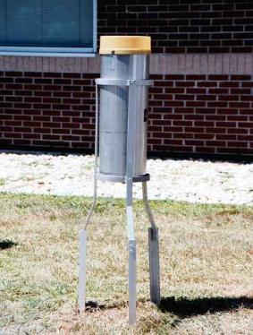
8 Why not in cities? Typical set-up rain gauge Distance to nearest obstacle: 2-4x height obstacle above rain gauge No wind influence (KNMI, 2000) Courtesy: kees floor.nl 9


9 10


")
10 Basisschool (Lansingerland, BS de Poort) Gemeentewerf (Hoogvliet, werf Gadering) Rioolgemaal (Bolnes, gemaal) 11


11 Hoe meten we neerslag radar 12
12 Rainfall radar Titel van de presentatie 13 xx
: 1 km 2 KNMI")
 (Courtesy")
13 Radar: spatial rainfall monitoring KNMI radars: 2 locations: de Bilt, Den Helder C-Band 4-8 GHz Spatial density (pixel size): 1 km 2 KNMI weather radar in De Bilt (Courtesy KNMI) Locations of weather radars in De Bilt and Den Helder and their 200-km range (circles) (Courtesy KNMI) 14
14 15


15 Limited value for cities: 1kmx1km resolution too coarse Low accuracy for high rainfall intensities Measurement at high altitude 16

16 17
![Flow [m3/s] mm/5min Data resolution for urban hydrology High degree of imperviousness fast runoff processes High spatial variability of urban functions Need for high resolution data: in time and in](/docs-images/92/109263481/images/17-0.jpg "space 0,8 Response times urban catchments: order of minutes 0 0,7 0,6 0,5 2 4 6 8 Drainage area Oranjepolder: 4.")
17 Flow [m3/s] mm/5min Data resolution for urban hydrology High degree of imperviousness fast runoff processes High spatial variability of urban functions Need for high resolution data: in time and in space 0,8 Response times urban catchments: order of minutes 0 0,7 0,6 0, Drainage area Oranjepolder: 4.9 km 2 0,4 0,3 0,2 0,1 0 00:00 00:15 00:30 00:45 01:00 01:15 01:30 01:45 02:00 02:16 Time [hh:mm]

18 Data resolution for urban hydrology 19
, 13 partners Case studies:")

19 RAINGAIN : high resolution rainfall data for urban flood prediction EU-project: 4 countries (B, F, NL, UK), 13 partners Case studies: Leuven, London, Paris, Rotterdam Rotterdam: Dual polarimetry, Doppler X-band radar Network of rain gaugees on the grond 20 Telegraaf, 11 mei 2013

")
20 Hoge resolution rainfall radar Example Cabauw: dual-polarimetric X-band radar DR= 30 m KNMI radar De Bilt DR= 1 km (Courtesy KNMI) 21
21 Radar Reflection Precipitation volume: Drop Size Distribution DSD(h n,t) l l l l l Radar level Ground level h DSD(h n-1,t) DSD(h 1,t) DSD(h 0,t) 22


22 Radar: Dual Polarimetry Polarimetric radar signal 23
 Reflectivity")
 Differential phase c)")
23 Combine: more accurate results a) Reflectivity (power) m 1 (h,v) & m 2 (h,v) b) Differential phase c) Rainfall rate 24


24 Radar height: 150 m ground truthing : rain gauges What happens between 150 m height and the ground? How to compare: rain gauge 0.2 m 2 vs radar pixel 30mx30m l l l l l Radar level Ground level h DSD(h n,t) DSD(h n-1,t) DSD(h 1,t) DSD(h 0,t) 25


25 Spatial resolution comparison Rainfall- maximum intensity map X-band radar 100 m X-band radar 500 m 26
26 Rainfall spatial and temporal resolution Titel van de presentatie 27 xx
27 Effect of spatial and temporal resolution on variability 1 km 5 min 333 m 2.5 min Principle of spatiotemporal downscaling 111 m 1.25 min 28
28 Effect of spatial and temporal resolution on variability Example: effect of spatial upscaling/averaging: area effect Rainfall radar measurement [mm/h] 50mx50m resolution Calculate: 100mx100m values 500mx500m values
29 Effect of spatial and temporal resolution on variability Example: effect of spatial upscaling/averaging: area effect Rainfall radar measurement [mm/h] 100mx100m resolution
30 Effect of spatial and temporal resolution on variability 13.6 Example: effect of spatial upscaling/averaging: area effect Rainfall radar measurement [mm/h] 500mx500m resolution 0 31
31 Effect of spatial and temporal resolution on variability 0 0,75 0,75 1,75 2 0,75 2,25 2 0,5 0,75 0,5 0 Example: effect of spatial upscaling/averaging: area effect Rainfall radar measurement [mm/h] 100mx100m resolution Max: 67.5 mm/h 1 2,25 5,5 6,75 10,5 10,5 5,5 3,25 2 1,75 0,75 0,5 1, ,25 13, ,5 16,25 9,25 4,75 3 1,5 0,5 1,25 9,5 18,75 27,5 37, ,5 16,25 4,25 1,75 1,5 0,5 0, ,5 52,5 42, ,75 5 1,25 0,5 1 10,25 32, , ,5 37,5 13 4,5 1,5 0,25 0, , ,75 22,5 4,25 0,75 0,5 0,75 1 7,5 13,75 23,75 22,5 17,5 14,25 5,5 1,75 0,75 0,5 1 1,5 4,5 4,75 7,75 13,75 10,5 3,5 0,75 0,75 0,75 0,75 0,75 0, ,75 5,5 3,5 0,5 0,25 0,75 0,75 0,75 0,5 0 0,5 0,5 1,25 2,25 1,25 0,25 0 0,5 0,75 0, ,5 0,
32 Effect of spatial and temporal resolution on variability 0 0,75 0,75 1,75 2 0,75 2,25 2 0,5 0,75 0,5 0 Example: effect of spatial upscaling/averaging: area effect Rainfall radar measurement [mm/h] 100mx100m resolution Max: 67.5 mm/h 1 2,25 5,5 6,75 10,5 10,5 5,5 3,25 2 1,75 0,75 0,5 1, ,25 13, ,5 16,25 9,25 4,75 3 1,5 0,5 1,25 9,5 18,75 27,5 37, ,5 16,25 4,25 1,75 1,5 0,5 0, ,5 52,5 42, ,75 5 1,25 0,5 1 10,25 32, , ,5 37,5 13 4,5 1,5 0,25 0, , ,75 22,5 4,25 0,75 0,5 0,75 1 7,5 13,75 23,75 22,5 17,5 14,25 5,5 1,75 0,75 0,5 1 1,5 4,5 4,75 7,75 13,75 10,5 3,5 0,75 0,75 0,75 0,75 0,75 0, ,75 5,5 3,5 0,5 0,25 0,75 0,75 0,75 0,5 0 0,5 0,5 1,25 2,25 1,25 0,25 0 0,5 0,75 0, ,5 0,
33 Effect of spatial and temporal resolution on variability 13,61 13,52 12,89 12,44 10,63 8,61 5,83 3,42 1,58 1,03 0,80 0,60 Example: effect of spatial upscaling/averaging: area effect Rainfall radar measurement [mm/h] 500mx500m resolution 13,61 13,52 12,89 12,46 10,58 8,60 5,83 3,42 1,63 1,03 0,80 0,60 13,54 13,43 12,78 12,36 10,46 8,47 5,67 3,26 1,55 0,97 0,70 0,60 14,09 13,99 13,28 12,77 10,75 8,57 5,87 3,33 1,50 0,85 0,72 0,56 13,73 13,56 12,79 12,18 9,80 7,38 5,21 2,83 1,16 0,67 0,50 0,63 13,30 13,13 12,24 11,60 9,13 7,08 4,86 2,20 1,11 0,71 0,50 0,57 10,08 9,88 8,85 8,06 5,73 3,83 3,00 1,03 0,63 0,50 0,50 0,50 5,24 5,00 4,56 4,27 3,05 2,23 1,17 0,72 0,60 0,53 0,60 0,60 2,80 2,73 2,38 2,47 1,84 0,89 0,50 0,50 0,56 0,42 0,38 0,25 Max: mm/h NB: values distorted by missing values along edges 1,40 1,30 1,13 1,22 0,96 0,43 0,33 0,40 0,42 0,33 0,33 0,00 0,75 0,75 0,65 0,72 0,50 0,29 0,25 0,30 0,38 0,17 0,00 0,00 0,50 0,50 0,30 0,33 0,38 0,14 0,00 0,00 0,00 0,00 0,00 0,00 34
34 Effect of spatial and temporal resolution on variability Example: effect of spatial upscaling/averaging: area effect Resolution Max value Mean STD 50mx50m mx100m x500m NB1: values distorted by missing values along edges NB2: rain gauge collector area m 2 << radar pixel size 35
35 Rainfall data in cities - summary Especially in urban areas: high temporal and spatial resolutions essential Available rainfall measurement techniques: Point measurements: Funnel: manual reading Rain gauge: tipping bucket, electronic rain gauge, optical rain gauge Disdrometers: measure drop size distribution Spatial measurements: Ground-based radar: varying spatial resolutions and accuracies 36
36 Rainfall data in cities - summary Available rainfall data, current practice: 1 rain gauge nearby (e.g. Delft: KNMI station R dam Airport) Radar images 1kmx1km (merged images De Bilt/Den Helder radars) Available temporal resolution: KNMI stations: 5 minutes, 33 stations in NL; 24 hours, 325 stations other stations: local projects, weather amateurs: variable resolution KNMI Radar (=buienradar and others): 5 minutes Rainfall record duration: KNMI stations: 10s of years other stations: months or a few years KNMI radar 1kmx1km since


37 RAINGAIN : high resolution rainfall data for urban flood prediction EU-project: 4 countries (B, F, NL, UK), 13 partners Case studies: Leuven, London, Paris, Rotterdam Rotterdam: High resolution X-band radar Rain gauge network High resolution DEM Urban drainage models incl 2D flooding Opportunities for traineeship and MSc research! 38
TOWARDS THE USE OF X-BAND DUAL POLARIMETRIC RADAR RAIN- FALL ESTIMATES IN URBAN HYDROLOGY
 TOWARDS THE USE OF X-BAND DUAL POLARIMETRIC RADAR RAIN- FALL ESTIMATES IN URBAN HYDROLOGY by G. Bruni (1), J.A.E. ten Veldhuis (1), T. Otto (2) and H. Leijnse (3) (1) Watermanagement Department, Delft
WP2: Fine-scale rainfall data acquisition and prediction:
 WP1 WP2: Fine-scale rainfall data acquisition and prediction: Objective: develop and implement a system for estimation and forecasting of fine-scale (100m, minutes) rainfall Rainfall estimation: combining
Improved rainfall estimates and forecasts for urban hydrological applications
 Improved rainfall estimates and forecasts for urban hydrological applications Innovyze User Days - Drainage and Flooding User Group Wallingford, 20 th June 2013 Contents 1. Context 2. Radar rainfall processing
Weather radar for urban hydrological applications: lessons learnt and research needs identified from 4 pilot catchments in North West Europe
 Weather radar for urban hydrological applications: lessons learnt and research needs identified from 4 pilot catchments in North West Europe J.A.E. ten Veldhuis 1, S. Ochoa Rodriguez 2, G. Bruni 1, A.
PLURISK project 'Forecasting and management of extreme rainfall induced risks in the urban environment'
 PLURISK project 'Forecasting and management of extreme rainfall induced risks in the urban environment' programme 'Science for a Sustainable Development' 1 st Follow-up Committee Meeting Brussels, 12 October
Flood Forecasting with Radar
 Flood Forecasting with Radar Miguel Angel Rico-Ramirez m.a.rico-ramirez@bristol.ac.uk Encuentro Internacional de Manejo del Riesgo por Inundaciones, UNAM, 22 th Jan 2013 Talk Outline Rainfall estimation
Weather radar rainfall for hydrological hazard risk management
 Weather radar rainfall for hydrological hazard risk management Dawei Han 韩大卫 Department of Civil Engineering University of Bristol, UK Hydrological hazards related to rainfall Floods Droughts Debris flows
Radar-raingauge data combination techniques: A revision and analysis of their suitability for urban hydrology
 9th International Conference on Urban Drainage Modelling Belgrade 2012 Radar-raingauge data combination techniques: A revision and analysis of their suitability for urban hydrology L. Wang, S. Ochoa, N.
Radar rain gauges new alternative for urban measurement networks. Copyright OTT Hydromet 2018
 Radar rain gauges new alternative for urban measurement networks Stormwater event in the city of Münster July 28 th 2014 4 Ernst Mennerich Stormwater event in the city of Münster July 28 th 2014 5 Ernst
Leuven case study. International workshop & project meeting Leuven, April 2012
 Leuven case study International workshop & project meeting Leuven, 16-17 April 2012 Johan Van Assel (Aquafin) Laurens Cas Decloedt, Patrick Willems (KU Leuven) Raingain Project meeting 17/04/2012 - Aquafin
A SPATIAL ANALYSIS OF RAINFALL DAMAGE DATA USING C-BAND WEATHER RADAR IMAGES
 A SPATIAL ANALYSIS OF RAINFALL DAMAGE DATA USING C-BAND WEATHER RADAR IMAGES Matthieu Spekkers 1,*, Matthijs Kok 1, Francois Clemens 1, Marie-claire ten Veldhuis 1 1 Delft University of Technology, the
Ricardo Reinoso-Rondinel 1, Guendalina Bruni 2, Marie-Claire ten Veldhuis 2 and Herman Russchenberg 1. Abstract
 119 1 TOWARD THE OPTIMAL RESOLUTION OF RAINFALL ESTIMATES TO OBTAIN RELIABLE URBAN HYDROLOGICAL RESPONSE: X-BAND POLARIMETRIC RADAR ESTIMATES APPLIED TO ROTTERDAM URBAN DRAINAGE SYSTEM Ricardo Reinoso-Rondinel
Minutes of the Second RainGain National Observers Group Meeting (Belgium) Prepared by Johan Van Assel (Aquafin)
 Prepared by Johan Van Assel (Aquafin)") Minutes of the Second RainGain National Observers Group (Belgium) Prepared by Johan Van Assel (Aquafin) Date: Wednesday 15th May 2013, from 9:00 to 14:30 Venue: Aquafin, Delta Building, room Schelde, Dijkstraat
Minutes of the Second RainGain National Observers Group (Belgium) Prepared by Johan Van Assel (Aquafin) Date: Wednesday 15th May 2013, from 9:00 to 14:30 Venue: Aquafin, Delta Building, room Schelde, Dijkstraat
Effect of spatiotemporal variation of rainfall on dissolved oxygen depletion in integrated catchment studies
 8 th International Conference on Sewer Processes and Networks August 31 September 2, 2016, Rotterdam, The Netherlands Effect of spatiotemporal variation of rainfall on dissolved oxygen depletion in integrated
Observation strategies for severe rain in The Netherlands
 Observation strategies for severe rain in The Netherlands Herman Russchenberg Delft University of Technology Challenge the future Our Earth is slowly warming The world population is moving into the cities
Radars, Hydrology and Uncertainty
 Radars, Hydrology and Uncertainty Francesca Cecinati University of Bristol, Department of Civil Engineering francesca.cecinati@bristol.ac.uk Supervisor: Miguel A. Rico-Ramirez Research objectives Study
Module 1. Lecture 2: Weather and hydrologic cycle (contd.)
") Lecture 2: Weather and hydrologic cycle (contd.) Hydrology Hydor + logos (Both are Greek words) Hydor means water and logos means study. Hydrology is a science which deals with the occurrence, circulation
Lecture 2: Weather and hydrologic cycle (contd.) Hydrology Hydor + logos (Both are Greek words) Hydor means water and logos means study. Hydrology is a science which deals with the occurrence, circulation
Thessaloniki, Greece
 9th International Conference on Urban Drainage Modelling Effects of Climate Change on the Estimation of Intensity-Duration- Frequency (IDF) curves for, Greece, Greece G. Terti, P. Galiatsatou, P. Prinos
THE DEVELOPMENT OF RAIN-BASED URBAN FLOOD FORECASTING METHOD FOR RIVER MANAGEMENT PRACTICE USING X-MP RADAR OBSERVATION
 Research Paper Advances in River Engineering, JSCE, Vol.19, 2013,June THE DEVELOPMENT OF RAIN-BASED URBAN FLOOD FORECASTING METHOD FOR RIVER MANAGEMENT PRACTICE USING X-MP RADAR OBSERVATION Seongsim YOON
High resolution radar rainfall for urban pluvial flood management: Lessons learnt from 10 pilots in North-West Europe within the RainGain project
 High resolution radar rainfall for urban pluvial flood management: Lessons learnt from 10 pilots in North-West Europe within the RainGain project Marie-claire TEN VELDHUIS 1*, Susana OCHOA-RODRIGUEZ 2,
Rainfall Analysis. Prof. M.M.M. Najim
 Rainfall Analysis Prof. M.M.M. Najim Learning Outcome At the end of this section students will be able to Estimate long term mean rainfall for a new station Describe the usage of a hyetograph Define recurrence
Radar Network for Urban Flood and Severe Weather Monitoring
 Radar Network for Urban Flood and Severe Weather Monitoring V. Chandrasekar 1 and Brenda Philips 2 Colorado State University, United States University of Massachusetts, United States And the full DFW team
Rainfall rate retrieval with IDRA, the polarimetric X-band radar at Cabauw, Netherlands
 Rainfall rate retrieval with IDRA, the polarimetric X-band radar at Cabauw, Netherlands Tobias Otto and Herman W.J. Russchenberg TU Delft Climate Institute, Department of Geoscience and Remote Sensing,
CIE4491 Lecture. Hydraulic design
 CIE4491 Lecture. Hydraulic design Marie-claire ten Veldhuis 19-9-013 Delft University of Technology Challenge the future Hydraulic design of urban stormwater systems Focus on sewer pipes Pressurized and
Bird migration monitoring across Europe using weather radar
 Bird migration monitoring across Europe using weather radar M. de Graaf 1, H. Leijnse 1, A. Dokter 2, J. Shamoun-Baranes 2, H. van Gasteren 3, J. Koistinen 4, and W. Bouten 2 1 Royal Netherlands Meteorological
Surface Hydrology Research Group Università degli Studi di Cagliari
 Surface Hydrology Research Group Università degli Studi di Cagliari Evaluation of Input Uncertainty in Nested Flood Forecasts: Coupling a Multifractal Precipitation Downscaling Model and a Fully-Distributed
Uncertainty in merged radar - rain gauge rainfall products
 Uncertainty in merged radar - rain gauge rainfall products Francesca Cecinati University of Bristol francesca.cecinati@bristol.ac.uk Supervisor: Miguel A. Rico-Ramirez This project has received funding
Improving Situational Awareness of Flash Flooding in a Small Urban Catchment by Integrating Meteorological Analysis into a Geospatial Framework
 Improving Situational Awareness of Flash Flooding in a Small Urban Catchment by Integrating Meteorological Analysis into a Geospatial Framework John M. Goff 1, Lesley-Ann Dupigny-Giroux 2, John Kilbride
High Resolution Radar Rainfall for Urban Pluvial Flood Control Lessons Learnt From Ten Pilots in North-West Europe Within the RainGain Project
 High Resolution Radar Rainfall for Urban Pluvial Flood Control Lessons Learnt From Ten Pilots in North-West Europe Within the RainGain Project Marie-claire TEN VELDHUIS 1*, Susana OCHOA-RODRIGUEZ 2, Guenda
Sensor networks and urban pluvial flood modelling in an urban catchment
 Environmental virtual observatories: managing catchments with wellies, sensors and smartphones Sensor networks and urban pluvial flood modelling in an urban catchment 28 th February 2013 Contents 1. Context
Results of Intensity-Duration- Frequency Analysis for Precipitation and Runoff under Changing Climate
 Results of Intensity-Duration- Frequency Analysis for Precipitation and Runoff under Changing Climate Supporting Casco Bay Region Climate Change Adaptation RRAP Eugene Yan, Alissa Jared, Julia Pierce,
Lecture 6: Precipitation Averages and Interception
 Lecture 6: Precipitation Averages and Interception Key Questions 1. How much and when does Whatcom County receive rain? 2. Where online can you find rainfall data for the state? 3. How is rainfall averaged
EFFICIENCY OF THE INTEGRATED RESERVOIR OPERATION FOR FLOOD CONTROL IN THE UPPER TONE RIVER OF JAPAN CONSIDERING SPATIAL DISTRIBUTION OF RAINFALL
 EFFICIENCY OF THE INTEGRATED RESERVOIR OPERATION FOR FLOOD CONTROL IN THE UPPER TONE RIVER OF JAPAN CONSIDERING SPATIAL DISTRIBUTION OF RAINFALL Dawen YANG, Eik Chay LOW and Toshio KOIKE Department of
A TEST OF THE PRECIPITATION AMOUNT AND INTENSITY MEASUREMENTS WITH THE OTT PLUVIO
 A TEST OF THE PRECIPITATION AMOUNT AND INTENSITY MEASUREMENTS WITH THE OTT PLUVIO Wiel M.F. Wauben, Instrumental Department, Royal Netherlands Meteorological Institute (KNMI) P.O. Box 201, 3730 AE De Bilt,
Sensor Guide WS100 Radar Precipitation Sensor
 Abbeon Cal, Inc., 1363 Donlon Street Unit 1, Ventura, CA 93003-8387 - 800-922-0977 www.abbeon.com - E-mail: abbeoncal@abbeon.com Sensor Guide WS100 Radar Precipitation Sensor October 2017 Sensor Guide:
Probabilistic forecasting for urban water management: A case study
 9th International Conference on Urban Drainage Modelling Belgrade 212 Probabilistic forecasting for urban water management: A case study Jeanne-Rose Rene' 1, Henrik Madsen 2, Ole Mark 3 1 DHI, Denmark,
Application of Real-Time Rainfall Information System to CSO control. 2 October 2011 Naruhito Funatsu METAWATER Co., Ltd.
 Application of Real-Time Rainfall Information System to CSO control 2 October 2011 Naruhito Funatsu METAWATER Co., Ltd. Presentation Points Objectives To verify the applicability of the real-time rainfall
A RADAR-BASED CLIMATOLOGY OF HIGH PRECIPITATION EVENTS IN THE EUROPEAN ALPS:
 2.6 A RADAR-BASED CLIMATOLOGY OF HIGH PRECIPITATION EVENTS IN THE EUROPEAN ALPS: 2000-2007 James V. Rudolph*, K. Friedrich, Department of Atmospheric and Oceanic Sciences, University of Colorado at Boulder,
Outline. Research Achievements
 Taiwan Typhoon and Flood Research Institute, National Applied Research Laboratories 11F., No.97, Sec. 1, Roosevelt Rd., Zhongzheng Dist., Taipei City 10093, Taiwan (R.O.C.) http://www.ttfri.narl.org.tw/eng/index.html
Danish experiences with short term forecasting in urban drainage applications
 Danish experiences with short term forecasting in urban drainage applications RainGain workshop on fine-scale rainfall nowcasting 31 March 214, Antwerp Associate Professor Søren Thorndahl Department of
SOP/EOP Implementation Plan -Overview for the Eastern Mediterranean Target Area Emmanouil Anagnostou
 SOP/EOP Implementation Plan -Overview for the Eastern Mediterranean Target Area Emmanouil Anagnostou University of Connecticut & Hellenic Center for Marine Research Contributions from Efrat Morin The Hebrew
Generating projected rainfall time series at sub-hourly time scales using statistical and stochastic downscaling methodologies
 Generating projected rainfall time series at sub-hourly time scales using statistical and stochastic downscaling methodologies S. Molavi 1, H. D. Tran 1,2, N. Muttil 1 1 School of Engineering and Science,
4 Precipitation. 4.1 Rainfall characteristics
 4 Precipitation 4.1 Rainfall characteristics As rainfall and rainfall properties are the main controlling factors in runoff production, the rainfall characteristics of the study area were carefully studied.
New design rainfalls. Janice Green, Project Director IFD Revision Project, Bureau of Meteorology
 New design rainfalls Janice Green, Project Director IFD Revision Project, Bureau of Meteorology Design Rainfalls Design Rainfalls Severe weather thresholds Flood forecasting assessing probability of rainfalls
Ed Tomlinson, PhD Bill Kappel Applied Weather Associates LLC. Tye Parzybok Metstat Inc. Bryan Rappolt Genesis Weather Solutions LLC
 Use of NEXRAD Weather Radar Data with the Storm Precipitation Analysis System (SPAS) to Provide High Spatial Resolution Hourly Rainfall Analyses for Runoff Model Calibration and Validation Ed Tomlinson,
Lecture 2: Precipitation
 2-1 GEOG415 Lecture 2: Precipitation Why do we study precipitation? Precipitation measurement -- depends on the study purpose. Non-recording (cumulative) Recording (tipping bucket) Important parameters
Drought Monitoring with Hydrological Modelling
 st Joint EARS/JRC International Drought Workshop, Ljubljana,.-5. September 009 Drought Monitoring with Hydrological Modelling Stefan Niemeyer IES - Institute for Environment and Sustainability Ispra -
SPATIAL AND TEMPORAL VARIABILITY OF DROP SIZE DISTRIBUTION FROM VERTICALLY POINTING MICRO RAIN RADAR (MRR)
") SPATIAL AND TEMPORAL VARIABILITY OF DROP SIZE DISTRIBUTION FROM VERTICALLY POINTING MICRO RAIN RADAR (MRR) Malte Diederich, Clemens Simmer and Alessandro Battaglia Meteorological Institute of the University
SPATIAL AND TEMPORAL VARIABILITY OF DROP SIZE DISTRIBUTION FROM VERTICALLY POINTING MICRO RAIN RADAR (MRR) Malte Diederich, Clemens Simmer and Alessandro Battaglia Meteorological Institute of the University
Exploring the role of new technologies in quantifying precipitation levels and urban flooding
 Exploring the role of new technologies in quantifying precipitation levels and urban flooding Jörg Rieckermann Urban Water Management Eawag, Swiss Federal Institute of Aquatic Science and Technology Motivation
Analysis of Radar-Rainfall Uncertainties and effects on Hydrologic Applications. Emad Habib, Ph.D., P.E. University of Louisiana at Lafayette
 Analysis of Radar-Rainfall Uncertainties and effects on Hydrologic Applications Emad Habib, Ph.D., P.E. University of Louisiana at Lafayette Motivation Rainfall is a process with significant variability
Local Area Weather Radar (LAWR) System to Approve Drainage Systems Capacity Case Study from Egedal - Denmark
 System to Approve Drainage Systems Capacity Case Study from Egedal - Denmark") Local Area Weather Radar (LAWR) System to Approve Drainage Systems Capacity Case Study from Egedal - Denmark Authors Sabah Al-Shididi Henrik S. Andersen Frank Hjulskov Presenter Sabah Al-Shididi MSc Environmental
Local Area Weather Radar (LAWR) System to Approve Drainage Systems Capacity Case Study from Egedal - Denmark Authors Sabah Al-Shididi Henrik S. Andersen Frank Hjulskov Presenter Sabah Al-Shididi MSc Environmental
STUDY ON THE PRECISION OF 1-MINUTE X-BAND MP RADAR RAINFALL DATA IN A SMALL URBAN WATERSHED
 Y. Yonese, et al., Int. J. Sus. Dev. Plann. Vol. 13, No. 4 (2018) 614 625 STUDY ON THE PRECISION OF 1-MINUTE X-BAND MP RADAR RAINFALL DATA IN A SMALL URBAN WATERSHED YOSHITOMO YONESE 1, AKIRA KAWAMURA
Hydrology and Hydraulics Design Report. Background Summary
 To: National Park Services Montezuma Castle National Monument Richard Goepfrich, Facility Manager From: Multicultural Technical Engineers Date: Tuesday - February 13, 2018 Subject: 30% Hydrology and Hydraulics
Preliminary assessment of LAWR performance in tropical regions with high intensity convective rainfall
 Preliary assessment of LAWR performance in tropical regions with high intensity convective rainfall Chris Nielsen: DHI Water and Environment (Malaysia), Fanny Dugelay, Universitéde Nice Sophia Antipolis,
Testing a Polarimetric Rainfall Algorithm and Comparison with a Dense Network of Rain Gauges.
 Testing a Polarimetric Rainfall Algorithm and Comparison with a Dense Network of Rain Gauges. Alexander Ryzhkov (1,2), Terry Schuur (1,2), Dusan Zrnic (1) 1 National Severe Storms Laboratory, 1313 Halley
Nesting and LBCs, Predictability and EPS
 Nesting and LBCs, Predictability and EPS Terry Davies, Dynamics Research, Met Office Nigel Richards, Neill Bowler, Peter Clark, Caroline Jones, Humphrey Lean, Ken Mylne, Changgui Wang copyright Met Office
The development of a Kriging based Gauge and Radar merged product for real-time rainfall accumulation estimation
 The development of a Kriging based Gauge and Radar merged product for real-time rainfall accumulation estimation Sharon Jewell and Katie Norman Met Office, FitzRoy Road, Exeter, UK (Dated: 16th July 2014)
Climate Change Impact on Intensity-Duration- Frequency Curves in Ho Chi Minh city
 Climate Change Impact on Intensity-Duration- Frequency Curves in Ho Chi Minh city Minh Truong Ha Institute of Meteorology, Hydrology and Climate Change, Hanoi, Vietnam Kuala Lumpur, 06-2018 Rationale Unpredictable
Haiti and Dominican Republic Flash Flood Initial Planning Meeting
 Dr Rochelle Graham Climate Scientist Haiti and Dominican Republic Flash Flood Initial Planning Meeting September 7 th to 9 th, 2016 Hydrologic Research Center http://www.hrcwater.org Haiti and Dominican
Seasonal Hydrological Forecasting in the Berg Water Management Area of South Africa
 Seasonal Hydrological Forecasting in the Berg Water Management Area of South Africa Trevor LUMSDEN and Roland SCHULZE University of KwaZulu-Natal, South Africa OUTLINE Introduction Objectives Study Area
Precipitation. Prof. M.M.M. Najim
 Precipitation Prof. M.M.M. Najim Learning Outcome At the end of this section students will be able to Explain different forms of precipitation Identify different types of rain gauges Measure rainfall using
Lecture 5: Precipitation
 Lecture 5: Precipitation Key Questions 1. What physical concepts control the formation of precipitation (air pressure, expanding gases and cooling, and vapor pressure)? 2. What are some air mass lifting
INDIAN INSTITUTE OF SCIENCE STOCHASTIC HYDROLOGY. Lecture -29 Course Instructor : Prof. P. P. MUJUMDAR Department of Civil Engg., IISc.
 INDIAN INSTITUTE OF SCIENCE STOCHASTIC HYDROLOGY Lecture -29 Course Instructor : Prof. P. P. MUJUMDAR Department of Civil Engg., IISc. Summary of the previous lecture Goodness of fit Chi-square test χ
Solution: The ratio of normal rainfall at station A to normal rainfall at station i or NR A /NR i has been calculated and is given in table below.
 3.6 ESTIMATION OF MISSING DATA Data for the period of missing rainfall data could be filled using estimation technique. The length of period up to which the data could be filled is dependent on individual
Precipitation estimate of a heavy rain event using a C-band solid-state polarimetric radar
 Precipitation estimate of a heavy rain event using a C-band solid-state polarimetric radar Hiroshi Yamauchi 1, Ahoro Adachi 1, Osamu Suzuki 2, Takahisa Kobayashi 3 1 Meteorological Research Institute,
ANALYSIS OF CONVECTIVE STRUCTURES USING METEOROLOGICAL RADAR DATA AND SURFACE DATA
 ANALYSIS OF CONVECTIVE STRUCTURES USING METEOROLOGICAL RADAR DATA AND SURFACE DATA Nordila A., Jestin J., 1 Siti Khadijah C.O. 2 Civil Engineering Department, Faculty of Engineering, Universiti Pertahanan
Effect of Storm Separation Time on Rainfall Characteristics-A Case Study of Johor, Malaysia
 European Journal of Scientific Research ISSN 1450-216X Vol.45 No.2 (2010), pp.162-167 EuroJournals Publishing, Inc. 2010 http://www.eurojournals.com/ejsr.htm Effect of Storm Separation Time on Rainfall
SPECIAL PROJECT PROGRESS REPORT
 SPECIAL PROJECT PROGRESS REPORT Progress Reports should be 2 to 10 pages in length, depending on importance of the project. All the following mandatory information needs to be provided. Reporting year
Mapping of Flooding Points and Rainfall Data using ArcGIS Rio de Janeiro City - RJ - Brazil Events
 RIO DE JANEIRO CITY HALL MUNICIPALSECRETARY OF SANITATION AND WATER RESOURCES - SMAR WATER SANITATION AND DRAINAGE AUTHORITY - RIOÁGUAS BOARD OF STUDIES AND PROJECTS MANAGEMENT OF RESEARCH AND TECHNICAL
Table (6): Annual precipitation amounts as recorded by stations X and Y. No. X Y
: Annual precipitation amounts as recorded by stations X and Y. No. X Y") Example: X and Y are two neighboring rainfall stations. Station X has complete records and station Y has some missing values. Find the linear correlation equation between the two series as mentioned in
Example: X and Y are two neighboring rainfall stations. Station X has complete records and station Y has some missing values. Find the linear correlation equation between the two series as mentioned in
Flash Flood Guidance System On-going Enhancements
 Flash Flood Guidance System On-going Enhancements Hydrologic Research Center, USA Technical Developer SAOFFG Steering Committee Meeting 1 10-12 July 2017 Jakarta, INDONESIA Theresa M. Modrick Hansen, PhD
Utilization of Dual-pol data
 WMO/ASEAN Training Workshop on Weather Radar Data Quality and Standardization Utilization of Dual-pol data 8 February 2018 Hiroshi Yamauchi Observation Department Japan Meteorological Agency Japan Meteorological
Assessment of rainfall observed by weather radar and its effect on hydrological simulation performance
 386 Hydrology in a Changing World: Environmental and Human Dimensions Proceedings of FRIED-Water 2014, Montpellier, France, October 2014 (IAHS Publ. 363, 2014). Assessment of rainfall observed by weather
Rain Sense Innovative and Social Sensing for Urban Extreme Weather Preparation
 Rain Sense Innovative and Social Sensing for Urban Extreme Weather Preparation 7/3/15 RJ Sips, W Koole, R Uijlenhoet, A Overeem, MB van Riemsdijk, MC ten Veldhuis Delft University of Technology Challenge
UFO Database. UFO Dissemination Workshop 23/04/2015. NLR, Amsterdam. Oleg A. Krasnov and the UFO team
 UFO Database UFO Dissemination Workshop 23/0/2015 NLR, Amsterdam Oleg A. Krasnov (o.a.krasnov@tudelft.nl) and the UFO team 2 / Outline UFO Database in Internet Database content Data collections UFO Toulouse
Merging Rain-Gauge and Radar Data
 Merging Rain-Gauge and Radar Data Dr Sharon Jewell, Obserations R&D, Met Office, FitzRoy Road, Exeter sharon.jewell@metoffice.gov.uk Outline 1. Introduction The Gauge and radar network Interpolation techniques
MAIN ATTRIBUTES OF THE PRECIPITATION PRODUCTS DEVELOPED BY THE HYDROLOGY SAF PROJECT RESULTS OF THE VALIDATION IN HUNGARY
 MAIN ATTRIBUTES OF THE PRECIPITATION PRODUCTS DEVELOPED BY THE HYDROLOGY SAF PROJECT RESULTS OF THE VALIDATION IN HUNGARY Eszter Lábó OMSZ-Hungarian Meteorological Service, Budapest, Hungary labo.e@met.hu
Fun with Weather Maps! (no, really stop laughing) AOSC 200 Tim Canty
 AOSC 200 Tim Canty") Fun with Weather Maps! (no, really stop laughing) AOSC 200 Tim Canty Class Web Site: http://www.atmos.umd.edu/~tcanty/aosc200 Topics for today: Observations Station Model Temperature Maps Pressure Maps
Fun with Weather Maps! (no, really stop laughing) AOSC 200 Tim Canty Class Web Site: http://www.atmos.umd.edu/~tcanty/aosc200 Topics for today: Observations Station Model Temperature Maps Pressure Maps
On the use of radar rainfall estimates and nowcasts in an operational heavy rainfall warning service
 On the use of radar rainfall estimates and nowcasts in an operational heavy rainfall warning service Alan Seed, Ross Bunn, Aurora Bell Bureau of Meteorology Australia The Centre for Australian Weather
RADAR Rainfall Calibration of Flood Models The Future for Catchment Hydrology? A Case Study of the Stanley River catchment in Moreton Bay, Qld
 RADAR Rainfall Calibration of Flood Models The Future for Catchment Hydrology? A Case Study of the Stanley River catchment in Moreton Bay, Qld A 1 Principal Engineer, Water Technology Pty Ltd, Brisbane,
Combining radar and rain gauges rainfall estimates using conditional merging: a case study
 Combining radar and rain gauges rainfall estimates using conditional merging: a case study Alberto Pettazzi, Santiago Salsón MeteoGalicia, Galician Weather Service, Xunta de Galicia, C/ Roma 6, 15707 Santiago
REQUIREMENTS FOR WEATHER RADAR DATA. Review of the current and likely future hydrological requirements for Weather Radar data
 WORLD METEOROLOGICAL ORGANIZATION COMMISSION FOR BASIC SYSTEMS OPEN PROGRAMME AREA GROUP ON INTEGRATED OBSERVING SYSTEMS WORKSHOP ON RADAR DATA EXCHANGE EXETER, UK, 24-26 APRIL 2013 CBS/OPAG-IOS/WxR_EXCHANGE/2.3
Regional Flash Flood Guidance and Early Warning System
 WMO Training for Trainers Workshop on Integrated approach to flash flood and flood risk management 24-28 October 2010 Kathmandu, Nepal Regional Flash Flood Guidance and Early Warning System Dr. W. E. Grabs
Intensity-Duration-Frequency Curve Update for Newfoundland and Labrador
 Intensity-Duration-Frequency Curve Update for Newfoundland and Labrador Allyson Bingeman 1 Juraj Cunderlik 1 Gerald Crane 2 Amir Ali Khan 3 1 GHD Limited 2 Office of Climate Change and Energy Efficiency
JMA/WMO Workshop on Quality Management of Surface Observations RA II WIGOS Project Tokyo, Japan, March 2018
 Tokyo, 22 March 2018 JMA/WMO Workshop on Quality Management of Surface Observations RA II WIGOS Project Tokyo, Japan, 19-23 March 2018 Accuracy of precipitation measurements, instrument calibration and
Severe Weather Watches, Advisories & Warnings
 Severe Weather Watches, Advisories & Warnings Tornado Watch Issued by the Storm Prediction Center when conditions are favorable for the development of severe thunderstorms and tornadoes over a larger-scale
Improving the applicability of radar rainfall estimates for urban pluvial flood modelling and forecasting
 Improving the applicability of radar rainfall estimates for urban pluvial flood modelling and forecasting Paper 19 Session 6: Operational Monitoring & Control Susana Ochoa-Rodriguez 1 *, Li-Pen Wang 1,2,
Demonstration in Lyon of real time integrated monitoring system supporting improved rainfall monitoring
 Demonstration in Lyon of real time integrated monitoring system supporting improved rainfall monitoring Demonstration in Lyon of real time integrated monitoring system supporting improved rainfall monitoring
Raindrops. Precipitation Rate. Precipitation Rate. Precipitation Measurements. Methods of Precipitation Measurement. are shaped liked hamburger buns!
 Precipitation Measurements Raindrops are shaped liked hamburger buns! (Smaller drops are more spherical) Dr. Christopher M. Godfrey University of North Carolina at Asheville Methods of Precipitation Measurement
Advantages of using GARR During Extreme Rain Events
 Advantages of using GARR During Extreme Rain Events Charles Yost Meteorologist Rainfall Analyst 1992-2014 OneRain Incorporated Importance of Understanding Rainfall Saving lives and property Flash floods,
Flood intelligence an international collaborative case study. Karin Geraghty, CIO, DEWNR
 Flood intelligence an international collaborative case study Karin Geraghty, CIO, DEWNR Karin.geraghty@sa.gov.au Flood has come the forefront of our thinking recently Victorian & Queensland Flood Inquiries
ERAD THE SIXTH EUROPEAN CONFERENCE ON RADAR IN METEOROLOGY AND HYDROLOGY
 Real-time adjustment of radar data for water management systems using a PDF technique: The City RainNet Project Chris. G. Collier 1, Rod Hawnt 2 and John Powell 2 1. National Centre for Atmospheric Science,
Innovative rainfall measurement devices in tropical regions
 Innovative rainfall measurement devices in tropical regions A comparative data analysis for Yangon and Bago, Myanmar Dorien Honingh 4208188 June 13, 2016 Source cover page: Reuters. (2015, August 4). After
Vertical Pointing Weather Radar for Built-up Urban Areas Rasmussen, Michael Robdrup; Thorndahl, Søren Liedtke; Schaarup-Jensen, Kjeld
 Aalborg Universitet Vertical Pointing Weather Radar for Built-up Urban Areas Rasmussen, Michael Robdrup; Thorndahl, Søren Liedtke; Schaarup-Jensen, Kjeld Published in: Confernce Proceedings : 11th International
Assessment of QPE results from 4 kw X-band Local Area Weather Radar (LAWR) evaluated with S-band radar data
 evaluated with S-band radar data") Assessment of QPE results from 4 kw X-band Local Area Weather Radar (LAWR) evaluated with S-band radar data Lisbeth Pedersen 1+3, Isztar. Zawadzki 2, Niels Einar Jensen 1 and Henrik Madsen 3, (1) DHI,
Assessment of QPE results from 4 kw X-band Local Area Weather Radar (LAWR) evaluated with S-band radar data Lisbeth Pedersen 1+3, Isztar. Zawadzki 2, Niels Einar Jensen 1 and Henrik Madsen 3, (1) DHI,
Changes to Extreme Precipitation Events: What the Historical Record Shows and What It Means for Engineers
 Changes to Extreme Precipitation Events: What the Historical Record Shows and What It Means for Engineers Geoffrey M Bonnin National Oceanic and Atmospheric Administration National Weather Service Office
Workshop on MCCOE Radar Meteorology /Climatology in Indonesia. Segel Ginting Wanny K. Adidarma
 Workshop on MCCOE Radar Meteorology /Climatology in Indonesia BPPT, 28 Februari 2013 JAKARTA FLOOD EARLY WARNING SYSTEM (J-FEWS) Segel Ginting Wanny K. Adidarma JCP (Joint Cooperation Program) Indonesia
TRANSBOUNDARY FLOOD FORECASTING THROUGH DOWNSCALING OF GLOBAL WEATHER FORECASTING AND RRI MODEL SIMULATION
 TRANSBOUNDARY FLOOD FORECASTING THROUGH DOWNSCALING OF GLOBAL WEATHER FORECASTING AND RRI MODEL SIMULATION Rashid Bilal 1 Supervisor: Tomoki Ushiyama 2 MEE15624 ABSTRACT The study comprise of a transboundary
The Sensitivity Analysis of Runoff from Urban Catchment Based on the Nonlinear Reservoir Rainfall-Runoff Model
 PUBLS. INST. GEOPHYS. POL. ACAD. SC., E-6 (390), 2006 The Sensitivity Analysis of Runoff from Urban Catchment Based on the Nonlinear Reservoir Rainfall-Runoff Model Marcin SKOTNICKI and Marek SOWIŃSKI
Sub-kilometer-scale space-time stochastic rainfall simulation
 Picture: Huw Alexander Ogilvie Sub-kilometer-scale space-time stochastic rainfall simulation Lionel Benoit (University of Lausanne) Gregoire Mariethoz (University of Lausanne) Denis Allard (INRA Avignon)