Local Area Weather Radar (LAWR) System to Approve Drainage Systems Capacity Case Study from Egedal - Denmark
|
|
|
- Madeleine Underwood
- 5 years ago
- Views:
Transcription
1 Local Area Weather Radar (LAWR) System to Approve Drainage Systems Capacity Case Study from Egedal - Denmark Authors Sabah Al-Shididi Henrik S. Andersen Frank Hjulskov Presenter Sabah Al-Shididi MSc Environmental Policy and Regulation (2002) MSc Environmental Engineering (2001) B.Sc. Civil Engineering (1987) Avedøre Wastewater Services Kanalholmen 28, 2650 Hvidovre, Denmark, tel , sas@spvand.dk
2 The aim of the paper 1. Reviewing the first LAWR implementation in Egedal 2. Identifying flooding service level of a drainage system through LAWR rain data implementation 3. Evaluating LAWR data for further optimization Mike by DHI Copenhagen 2
3 Slagslunde Ølstykkest.town Ølstykke Stenløse Veksø Ganløse Smørum ~35 km west of Copenhagen Population: Area: 125 km2 722 km rainwater pipes 100 detention tanks/basins 173 pump stations 2 rain gauges in 2008 Now 7 rain gauges Mike by DHI Copenhagen 3
4 The objectives of the LAWR project 1. Rising the level of response in flood management 2. Obtaining online spatial rain data for every catchment 3. Dividing the service catchment to the desired number of sub-catchments 4. Detailed rain data for hydraulic simulations 5. Identifying the service level of the sewer catchments 6. SMS warning system 7. LAWR website 8. Forecasting Mike by DHI Copenhagen 4

5 The LAWR Project in Egedal Mike by DHI Copenhagen 5


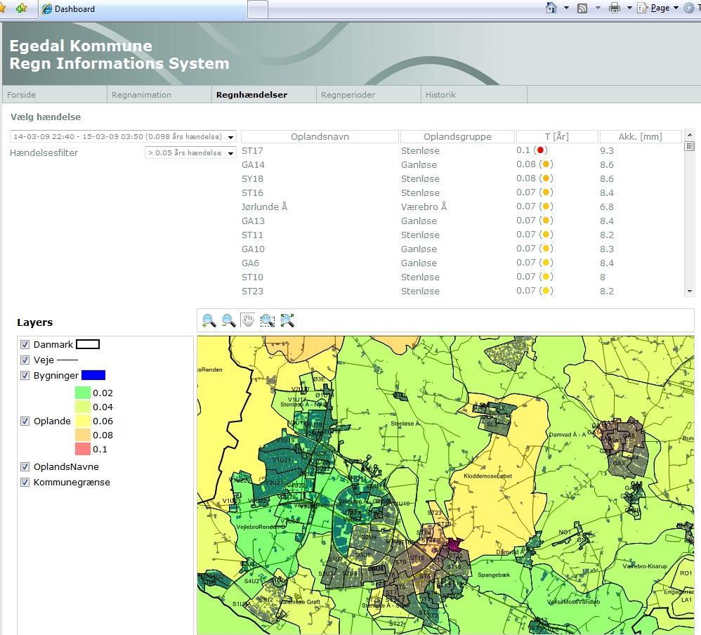

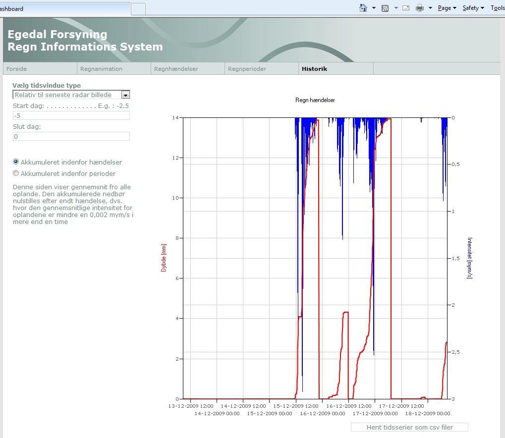

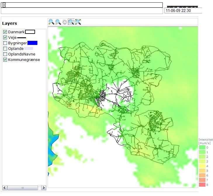
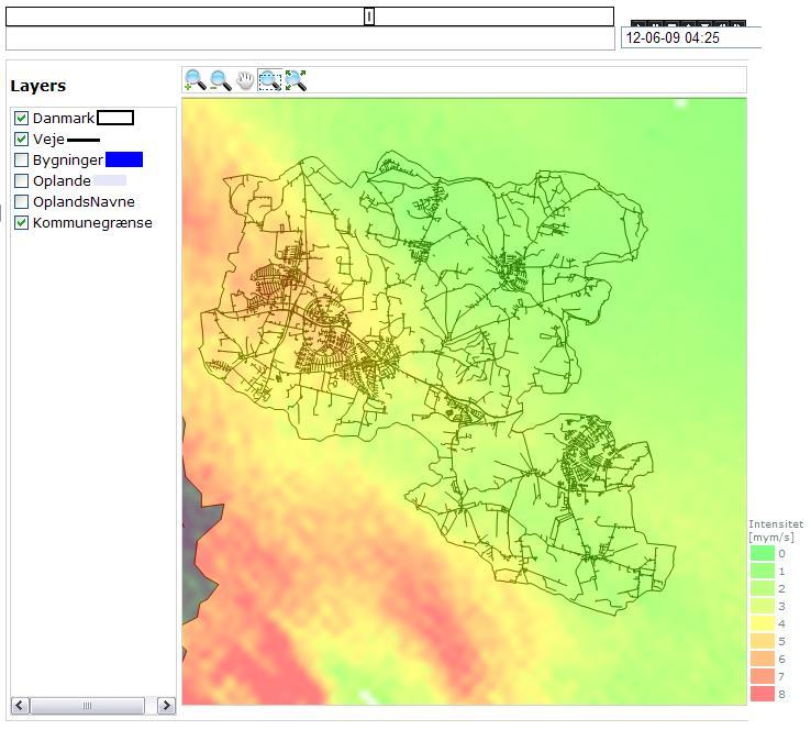
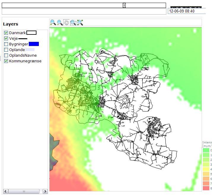
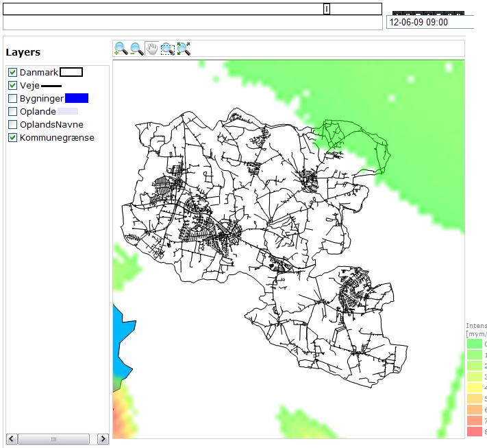
6 LAWR website Rain Information System Mike by DHI Copenhagen 6


7 Depth (mm) Intensity (mym/s) June :45: :00:00 Rain event June Radar Calib. (mym/s) :15: :30:00 Radar Calib. (mm) :45: mm in approx. 1½ day Mike by DHI Copenhagen 7


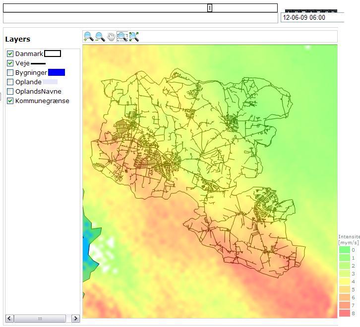

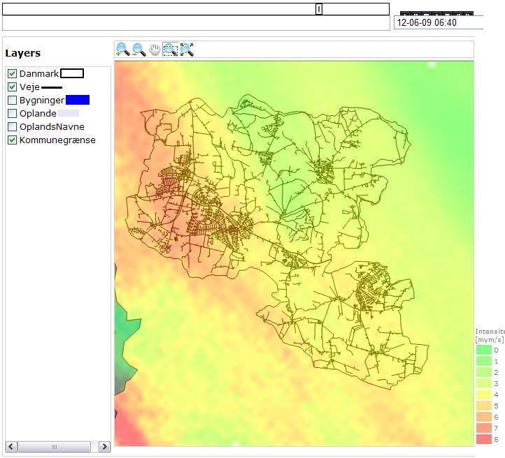

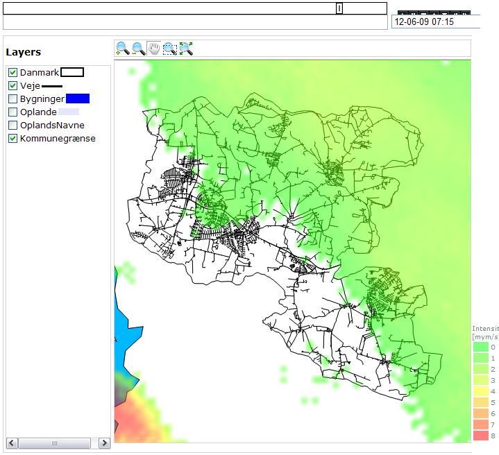
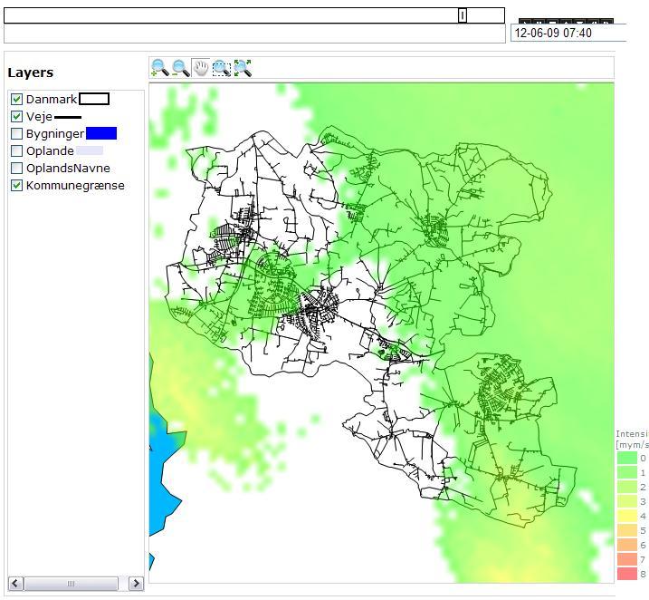

8 11-13 June Mike by DHI Copenhagen 8
9 Intensity (mym/s) June Over 100-year return period 100 Return period (T) estimation of Radar calibrated data Rain event June in Egedal 10 1 Radar Calib. T=100 T=50 T=20 T=10 T=5 T=2 T= Duration (min.) Mike by DHI Copenhagen 9
10 Depth (mm) Intensity (mym/s) Depth (mm) Intensity (mym/s) June - Calibration I = C X R I is calibrated radar count of intensity (mym/s) C is calibration factor R is radar count of intensity (mym/s) Selected rain data in Egedal on June Selected rain data in Egedal on June Stenløse (mm) ST1_Radar Calib. (mm) Stenløse (mym/s) ST1_Radar Calib. (mym/s) Ganløse (mm) GA4_Radar Calibrated (mm) Ganløse (mym/s) GA4_Radar Calibrated (mym/s) : : : : : : : : : : : : : : Mike by DHI Copenhagen 10
11 Intensity (mym/s) June - Calibration Return period (T) estimation of rain event in Egedal June 100 Ganløse 10 GA4_Radar Calib. T=1 T=2 T=5 1 T=10 T=20 T=50 T= Duration (min.) Mike by DHI Copenhagen 11
12 Intensity (mym/s) June - Calibration Return period (T) estimation of rain event in Egedal June 100 Stenløse 10 ST1_Radar Calib. T=1 T=2 T=5 1 T=10 T=20 T=50 T= Duration (min.) Mike by DHI Copenhagen 12
13 11-13 June 79 mm 97 mm 115 mm 132 mm 150 mm SG 116 mm GG 73 mm Mike by DHI Copenhagen 13
14 Capacity [Liter/m2] or [mm] What happened on June? Terrain SVK 27 allows water level to raise up to the terrain level under T=5 as a maximum level. T=5 T=10 According to SVK 27 the allowed maximum water level is to the terrain level under T=10 Design of rainwater system is full-flow pipe under T=1 T=1 T=2 Design of combined system is full-flow pipe under T = 2 Rain water Maximum capacity before flooding in liter/m2 according to SVK27 compared to the rainfall event on June Combined SG 116 mm GG 73 mm Most affected catchments on June Average depth of rainfall June Least affected catchments on June Category of capacity Combined sew er SVK27 Rainw ater sew er SVK Mike by DHI Copenhagen 14
15 Catchment validation No flooding in T 5 RS catchment approved No flooding in T 10 CS catchment approved Future T=5 and T=10 can be used on the same catchments. The above screening tool can be validated by calibrated and verified hydraulic models of the same catchments Mike by DHI Copenhagen 15
16 Uncertainties of the case study The LAWR was located more than 20 km northeast of Egedal 250X250m spatial pixel Locally installed LAWR 100X100m pixel Just two available rain gauges have been used in the calibration Calibration approx. 20 ha catchment against one spatial point (Rain gauge) One spatial pixel (250 X 250 m) against a rain gauge would have been more reliable Linear and static calibration Using the same factor of calibration on all catchments without considering the differences in catchment areas, location from radar antenna, etc Mike by DHI Copenhagen 16

17 Radar signal errors Permanent echoes Spurious echoes High radar beam Drop size wrong reflection Snow effect - bright band Bent radar beam due to temperature change Mike by DHI Copenhagen 17
18 Advantages of the case study Effective visual informative online tool during the rain event Supported faster decision making Detailed, instantaneous and integrated rainfall intensities 5-minute real time data 1-minute real time Data for each and every sub-catchment Spatial rainfall estimates over a wide area instead of depending on just a few rain gauges in Egedal First time privilege of online monitoring of the rain event Online high resolution detection of locations of frontal showers Mike by DHI Copenhagen 18
19 Future perspectives 1. Numerical forecast models are an essential function that has to be developed for future implementation for scenarios drawing of event from flooding down to the outlet of the catchment 2. Developing warning systems and reducing at the same time false warnings 3. Online dynamic calibration is a necessary integration with online data validation 4. Well calibrated radar counts to be used in hydraulic modelling for each catchment 5. Integrating data from a net of LAWR can be more reliable than data from single radar. Thus, organising radar data administration is a future task to optimize local and regional radar data system Mike by DHI Copenhagen 19
20 Conclusions Calibrated radar data can help to identify the capacity problems, as local flood events could be related directly to local intensity and depth of rain. Preliminary tool of risk assessment for evaluating drainage system capacity in accordance with the service standards. Online data from radar supported effectively decision making during the storm event. An overall image of the event assisted explaining why flooding has happened. Calibrated data supported the basis of decision making in future events in terms of priorities. Radar is an instantaneous spatial integrated data source need to be optimized to be reliable for more accurate estimations compared to data from point located non-spatial rain gauges. Radar is a larger scale of quantitative data source for hydraulic simulations and need to be optimised to be also qualitative data source Mike by DHI Copenhagen 20
21 Thank you for your attention Mike by DHI Copenhagen 21
22 Local Area Weather Radar (LAWR) System to Approve Drainage Systems Capacity Case Study from Egedal - Denmark Authors Sabah Al-Shididi 1 Henrik S. Andersen 2 Frank Hjulskov 3 Presenter Sabah Al-Shididi MSc Environmental Policy and Regulation (2002) MSc Environmental Engineering (2001) B.Sc. Civil Engineering (1987) Avedøre Wastewater Services Kanalholmen 28, 2650 Hvidovre, Denmark, tel , sas@spvand.dk
Demonstration of real-time integrated monitoring system supporting improved rainfall monitoring (D 1.3.8) in Aarhus. Demonstration Report
 in Aarhus. Demonstration Report") Demonstration of real-time integrated monitoring system supporting improved rainfall monitoring (D 1.3.8) in Aarhus Demonstration Report Demonstration of real-time integrated monitoring system supporting
Demonstration of real-time integrated monitoring system supporting improved rainfall monitoring (D 1.3.8) in Aarhus Demonstration Report Demonstration of real-time integrated monitoring system supporting
Challenges from Urban Drainage. Jesper Ellerbæk Nielsen Aalborg University, Denmark Department of Civil Engineering
 Challenges from Urban Drainage Jesper Ellerbæk Nielsen Aalborg University, Denmark Department of Civil Engineering Status for LAWR X-band integration into baltrad Challenges in using baltrad for urban
Probabilistic forecasting for urban water management: A case study
 9th International Conference on Urban Drainage Modelling Belgrade 212 Probabilistic forecasting for urban water management: A case study Jeanne-Rose Rene' 1, Henrik Madsen 2, Ole Mark 3 1 DHI, Denmark,
Danish experiences with short term forecasting in urban drainage applications
 Danish experiences with short term forecasting in urban drainage applications RainGain workshop on fine-scale rainfall nowcasting 31 March 214, Antwerp Associate Professor Søren Thorndahl Department of
Preliminary assessment of LAWR performance in tropical regions with high intensity convective rainfall
 Preliary assessment of LAWR performance in tropical regions with high intensity convective rainfall Chris Nielsen: DHI Water and Environment (Malaysia), Fanny Dugelay, Universitéde Nice Sophia Antipolis,
Leuven case study. International workshop & project meeting Leuven, April 2012
 Leuven case study International workshop & project meeting Leuven, 16-17 April 2012 Johan Van Assel (Aquafin) Laurens Cas Decloedt, Patrick Willems (KU Leuven) Raingain Project meeting 17/04/2012 - Aquafin
Operational modelling & forecasting in urban catchments. Richard Body Product Sector Leader Operational Forecasting
 Operational modelling & forecasting in urban catchments Richard Body Product Sector Leader Operational Forecasting Contents What is operational forecasting Innovyze software ICMLive components Benefits
Radar-raingauge data combination techniques: A revision and analysis of their suitability for urban hydrology
 9th International Conference on Urban Drainage Modelling Belgrade 2012 Radar-raingauge data combination techniques: A revision and analysis of their suitability for urban hydrology L. Wang, S. Ochoa, N.
Flash Flood Guidance System On-going Enhancements
 Flash Flood Guidance System On-going Enhancements Hydrologic Research Center, USA Technical Developer SAOFFG Steering Committee Meeting 1 10-12 July 2017 Jakarta, INDONESIA Theresa M. Modrick Hansen, PhD
Radar Based Flow and Water Level Forecasting in Sewer Systems Thorndahl, Søren Liedtke; Rasmussen, Michael Robdrup; Grum, M.; Neve, S. L.
 Aalborg Universitet Radar Based Flow and Water Level Forecasting in Sewer Systems Thorndahl, Søren Liedtke; Rasmussen, Michael Robdrup; Grum, M.; Neve, S. L. Published in: UrbanRain09 : 8th International
Application of Real-Time Rainfall Information System to CSO control. 2 October 2011 Naruhito Funatsu METAWATER Co., Ltd.
 Application of Real-Time Rainfall Information System to CSO control 2 October 2011 Naruhito Funatsu METAWATER Co., Ltd. Presentation Points Objectives To verify the applicability of the real-time rainfall
State-space calibration of radar rainfall and stochastic flow forecasting for use in real-time Control of urban drainage systems
 State-space calibration of radar rainfall and stochastic flow forecasting for use in real-time Control of urban drainage systems 9th Int. Conf. On Urban Drainage Modeling Roland Löwe *, Peter Steen Mikkelsen,
12/07/2017. Flash Flood Warning Service, an advanced approach towards flood resilient cities Floodplain Management Association Conference, Newcastle
 12/07/2017 Worldwide problem: Flash Floods Flash Floods are a Global Problem Flash Flood Warning Service, an advanced approach towards flood resilient cities Floodplain Management Association Conference,
Radars, Hydrology and Uncertainty
 Radars, Hydrology and Uncertainty Francesca Cecinati University of Bristol, Department of Civil Engineering francesca.cecinati@bristol.ac.uk Supervisor: Miguel A. Rico-Ramirez Research objectives Study
National Weather Service Flood Forecast Needs: Improved Rainfall Estimates
 National Weather Service Flood Forecast Needs: Improved Rainfall Estimates Weather Forecast Offices Cleveland and Northern Indiana Ohio River Forecast Center Presenter: Sarah Jamison, Service Hydrologist
THE DEVELOPMENT OF RAIN-BASED URBAN FLOOD FORECASTING METHOD FOR RIVER MANAGEMENT PRACTICE USING X-MP RADAR OBSERVATION
 Research Paper Advances in River Engineering, JSCE, Vol.19, 2013,June THE DEVELOPMENT OF RAIN-BASED URBAN FLOOD FORECASTING METHOD FOR RIVER MANAGEMENT PRACTICE USING X-MP RADAR OBSERVATION Seongsim YOON
Towards a probabilistic hydrological forecasting and data assimilation system. Henrik Madsen DHI, Denmark
 Towards a probabilistic hydrological forecasting and data assimilation system Henrik Madsen DHI, Denmark Outline Hydrological forecasting Data assimilation framework Data assimilation experiments Concluding
Climate Adaptation Challenges for Boston s Water and Sewer Systems
 National Association of Flood & Stormwater Management Agencies Climate Adaptation Challenges for Boston s Water and Sewer Systems John P Sullivan P.E. October 15,2014 Boston 1630 Boston 1630-2012 Boston
Improved rainfall estimates and forecasts for urban hydrological applications
 Improved rainfall estimates and forecasts for urban hydrological applications Innovyze User Days - Drainage and Flooding User Group Wallingford, 20 th June 2013 Contents 1. Context 2. Radar rainfall processing
CSO Post-Construction Monitoring and Performance Assessment
 Massachusetts Water Resources Authority CSO Post-Construction Monitoring and Performance Assessment Jeremy R. Hall, Project Manager Operations/Engineering & Construction Wastewater Advisory Committee December
Presented by Jerry A. Gomez, P.E. National Hydropower Association Northeast Regional Meeting - September 17, 2009
 Presented by Jerry A. Gomez, P.E. National Hydropower Association Northeast Regional Meeting - September 17, 2009 Defining Probable Maximum Precipitation (PMP) PMP is the theoretically greatest depth of
Floodplain Risk Management in Dungog after the April 2015 Super Storm. Presentation Outline
 Presentation Outline Floodplain Risk Management in after the April 2015 Super Storm Rohan Hudson, Royal HaskoningDHV FMA 2017 Preparing for the Next Great Flood 17th May 2017 Background and Flood Mechanisms
The University of Akron. William Troyer The Dr. Gary B. and Pamela S. Williams Honors College
 The University of Akron IdeaExchange@UAkron Honors Research Projects The Dr. Gary B. and Pamela S. Williams Honors College Spring 2018 Applying Control Logic to the End of the Ohio Canal Interceptor Tunnel
Demonstration in Lyon of real time integrated monitoring system supporting improved rainfall monitoring
 Demonstration in Lyon of real time integrated monitoring system supporting improved rainfall monitoring Demonstration in Lyon of real time integrated monitoring system supporting improved rainfall monitoring
FFGS Concept HYDROLOGIC RESEARCH CENTER. 2 May 2017
 FFGS Concept HYDROLOGIC RESEARCH CENTER 2 May 2017 Research and Development History 1970-1988: US NWS Produces FFG statistically for each River Forecast Center. Also, research in adaptive site specific
Strategic Radar Enhancement Project (SREP) Forecast Demonstration Project (FDP) The future is here and now
 Forecast Demonstration Project (FDP) The future is here and now") Strategic Radar Enhancement Project (SREP) Forecast Demonstration Project (FDP) The future is here and now Michael Berechree National Manager Aviation Weather Services Australian Bureau of Meteorology
Strategic Radar Enhancement Project (SREP) Forecast Demonstration Project (FDP) The future is here and now Michael Berechree National Manager Aviation Weather Services Australian Bureau of Meteorology
FROM FLOOD FORECAST TO FLOOD FIGHTING Georg Johann , Tiel
 FROM FLOOD FORECAST TO FLOOD FIGHTING Georg Johann 2016-11-04, Tiel Dutch-German exchange of knowledge and experience COMING FROM FORECASTS TO EFFECTIVE FLOOD DEFENDING EMERGENCY MEASURES Flood forecasting
WP2: Fine-scale rainfall data acquisition and prediction:
 WP1 WP2: Fine-scale rainfall data acquisition and prediction: Objective: develop and implement a system for estimation and forecasting of fine-scale (100m, minutes) rainfall Rainfall estimation: combining
Outline. Research Achievements
 Taiwan Typhoon and Flood Research Institute, National Applied Research Laboratories 11F., No.97, Sec. 1, Roosevelt Rd., Zhongzheng Dist., Taipei City 10093, Taiwan (R.O.C.) http://www.ttfri.narl.org.tw/eng/index.html
Richard Body (Innovyze), Ruth Clarke (Innovyze) and William Neale (Thames Water)
, Ruth Clarke (Innovyze) and William Neale (Thames Water)") Real-time Operational Modelling of Sewers: A Case Study Richard Body (Innovyze), Ruth Clarke (Innovyze) and William Neale (Thames Water) Keywords: Operational modelling, forecasting, hydraulic modelling,
Real-time Operational Modelling of Sewers: A Case Study Richard Body (Innovyze), Ruth Clarke (Innovyze) and William Neale (Thames Water) Keywords: Operational modelling, forecasting, hydraulic modelling,
HYDROLOGICAL MODELING APPLICATIONS OF HIGH RESOLUTION RAIN RADAR
 HYDROLOGICAL MODELING APPLICATIONS OF HIGH RESOLUTION RAIN RADAR Luke Sutherland-Stacey, Paul Shucksmith and Geoff Austin Physics Department, University of Auckland ABSTRACT In many hydrological modelling
NJ Community Collaborative Rain, Hail and Snow Network
 NJ Community Collaborative Rain, Hail and Snow Network Mathieu Gerbush NJ Assistant State Climatologist/Climate Services Co-CoCoRaHS Coordinator NJ Agricultural Experiment Station School of Environmental
REQUIREMENTS FOR WEATHER RADAR DATA. Review of the current and likely future hydrological requirements for Weather Radar data
 WORLD METEOROLOGICAL ORGANIZATION COMMISSION FOR BASIC SYSTEMS OPEN PROGRAMME AREA GROUP ON INTEGRATED OBSERVING SYSTEMS WORKSHOP ON RADAR DATA EXCHANGE EXETER, UK, 24-26 APRIL 2013 CBS/OPAG-IOS/WxR_EXCHANGE/2.3
DEVELOPMENT OF A FORECAST EARLY WARNING SYSTEM ethekwini Municipality, Durban, RSA. Clint Chrystal, Natasha Ramdass, Mlondi Hlongwae
 DEVELOPMENT OF A FORECAST EARLY WARNING SYSTEM ethekwini Municipality, Durban, RSA Clint Chrystal, Natasha Ramdass, Mlondi Hlongwae LOCATION DETAILS AND BOUNDARIES ethekwini Municipal Area = 2297 km 2
PLURISK project 'Forecasting and management of extreme rainfall induced risks in the urban environment'
 PLURISK project 'Forecasting and management of extreme rainfall induced risks in the urban environment' programme 'Science for a Sustainable Development' 1 st Follow-up Committee Meeting Brussels, 12 October
Aurora Bell*, Alan Seed, Ross Bunn, Bureau of Meteorology, Melbourne, Australia
 15B.1 RADAR RAINFALL ESTIMATES AND NOWCASTS: THE CHALLENGING ROAD FROM RESEARCH TO WARNINGS Aurora Bell*, Alan Seed, Ross Bunn, Bureau of Meteorology, Melbourne, Australia 1. Introduction Warnings are
Flood Risk Forecasts for England and Wales: Production and Communication
 Staines Surrey Flood Risk Forecasts for England and Wales: Production and Communication Jon Millard UEF 2015 : Quantifying and Communicating Uncertainty FFC What is the FFC? Successful partnership between
D. MATHEMATICAL MODEL AND SIMULATION
 D. MATHEMATICAL MODEL AND SIMULATION D - i TABLE OF CONTENTS D.1 Objective of Model Development... D - 1 D.2 Selection of Software... D - 1 D.3 General Steps of Simulation by MOUSE... D - 1 D.4 Cases of
LIMITS OF RADAR RAINFALL FORECASTING FOR SEWAGE SYSTEM MANAGEMENT : RESULTS AND APPLICATION IN NANCY.
 8th ICUSD, 3 August 999, Sydney/Australia, proceeding Vol., pp. 44-449 LIMITS OF RADAR RAINFALL FORECASTING FOR SEWAGE SYSTEM MANAGEMENT : RESULTS AND APPLICATION IN NANCY. FAURE D.*, SCHMITT J.P.*, AUCHET
EFFICIENCY OF THE INTEGRATED RESERVOIR OPERATION FOR FLOOD CONTROL IN THE UPPER TONE RIVER OF JAPAN CONSIDERING SPATIAL DISTRIBUTION OF RAINFALL
 EFFICIENCY OF THE INTEGRATED RESERVOIR OPERATION FOR FLOOD CONTROL IN THE UPPER TONE RIVER OF JAPAN CONSIDERING SPATIAL DISTRIBUTION OF RAINFALL Dawen YANG, Eik Chay LOW and Toshio KOIKE Department of
New approaches to warning: the role of radar
 New approaches to warning: the role of radar John Handmer Centre for Risk and Community Safety, RMIT University Today The risk we want to reduce, and how much impact can we have on the risk of disasters?
Report on the demonstration in Gliwice of enhanced real-time measuring and forecasting technologies for combined sewer systems (D 1.3.
 Report on the demonstration in Gliwice of enhanced real-time measuring and forecasting technologies for combined sewer systems (D 1.3.11) Demonstration Report Report on the demonstration in Gliwice of
DETECTION AND FORECASTING - THE CZECH EXPERIENCE
 1 STORM RAINFALL DETECTION AND FORECASTING - THE CZECH EXPERIENCE J. Danhelka * Czech Hydrometeorological Institute, Prague, Czech Republic Abstract Contribution presents the state of the art of operational
Aviation Hazards: Thunderstorms and Deep Convection
 Aviation Hazards: Thunderstorms and Deep Convection TREND Diagnosis of thunderstorm hazards using imagery Contents Satellite imagery Visible, infrared, water vapour Basic cloud identification Identifying
Workshop on MCCOE Radar Meteorology /Climatology in Indonesia. Segel Ginting Wanny K. Adidarma
 Workshop on MCCOE Radar Meteorology /Climatology in Indonesia BPPT, 28 Februari 2013 JAKARTA FLOOD EARLY WARNING SYSTEM (J-FEWS) Segel Ginting Wanny K. Adidarma JCP (Joint Cooperation Program) Indonesia
USING GIS IN WATER SUPPLY AND SEWER MODELLING AND MANAGEMENT
 USING GIS IN WATER SUPPLY AND SEWER MODELLING AND MANAGEMENT HENRIETTE TAMAŠAUSKAS*, L.C. LARSEN, O. MARK DHI Water and Environment, Agern Allé 5 2970 Hørsholm, Denmark *Corresponding author, e-mail: htt@dhigroup.com
Weather Radar and A3 Introduction
 Weather Radar and A3 Introduction The term RADAR is an acronym formed from the term Radio Detection and Ranging. Nikola Tesla (of electric car fame) suggested in 1900 that moving targets should be observable
MODERN TECHNOLOGIES IN HYDRO-METEOROLOGICAL INFORMATION SYSTEMS
 MODERN TECHNOLOGIES IN HYDRO-METEOROLOGICAL INFORMATION SYSTEMS MARK HEGGLI, INNOVATIVE HYDROLOGY CONSULTING METEOROLOGIST/HYDROLOGIST TO THE WORLD BANK AREAS OF TECHNOLOGY ADVANCEMENT RECENT TECHNOLOGY
Assessment of QPE results from 4 kw X-band Local Area Weather Radar (LAWR) evaluated with S-band radar data
 evaluated with S-band radar data") Assessment of QPE results from 4 kw X-band Local Area Weather Radar (LAWR) evaluated with S-band radar data Lisbeth Pedersen 1+3, Isztar. Zawadzki 2, Niels Einar Jensen 1 and Henrik Madsen 3, (1) DHI,
Assessment of QPE results from 4 kw X-band Local Area Weather Radar (LAWR) evaluated with S-band radar data Lisbeth Pedersen 1+3, Isztar. Zawadzki 2, Niels Einar Jensen 1 and Henrik Madsen 3, (1) DHI,
GeoSpatial Water Distribution, Sanitary Sewer and Stormwater Network Modeling
 2009 Bentley Systems, Incorporated GeoSpatial Water Distribution, Sanitary Sewer and Stormwater Network Modeling Angela Battisti, Gary Griffiths Bentley Systems Inc Presenter Profile Angela Battisti, CE,
Assessment of rainfall observed by weather radar and its effect on hydrological simulation performance
 386 Hydrology in a Changing World: Environmental and Human Dimensions Proceedings of FRIED-Water 2014, Montpellier, France, October 2014 (IAHS Publ. 363, 2014). Assessment of rainfall observed by weather
Exploring the role of new technologies in quantifying precipitation levels and urban flooding
 Exploring the role of new technologies in quantifying precipitation levels and urban flooding Jörg Rieckermann Urban Water Management Eawag, Swiss Federal Institute of Aquatic Science and Technology Motivation
CIE4491 Lecture. How to quantify stormwater flow urban rainfall data and resolution Marie-claire ten Veldhuis
 CIE4491 Lecture. How to quantify stormwater flow urban rainfall data and resolution Marie-claire ten Veldhuis 18-9-2013 Delft University of Technology Challenge the future Coping with heavy rainfall -
URBAS Prediction and management of flash floods in urban areas
 URBAS Prediction and management of flash floods in urban areas 1 Thomas Einfalt, Klaus Friedeheim, Andreas Wagner Project funded by the Federal Ministry of Education and Research BMBF (Germany) as a part
A Comparative Study of the National Water Model Forecast to Observed Streamflow Data
 A Comparative Study of the National Water Model Forecast to Observed Streamflow Data CE394K GIS in Water Resources Term Project Report Fall 2018 Leah Huling Introduction As global temperatures increase,
Flash flood forecasting and warning infrastructures of National Meteorology and Hydrological Services of Cambodia
 Development and Implementation of the South East Asia Flash Flood Guidance System (SEAFFGS) Ha Noi, Viet Nam, 20-23 November 2017 Flash flood forecasting and warning infrastructures of National Meteorology
Understanding Weather and Climate Risk. Matthew Perry Sharing an Uncertain World Conference The Geological Society, 13 July 2017
 Understanding Weather and Climate Risk Matthew Perry Sharing an Uncertain World Conference The Geological Society, 13 July 2017 What is risk in a weather and climate context? Hazard: something with the
Sensor networks and urban pluvial flood modelling in an urban catchment
 Environmental virtual observatories: managing catchments with wellies, sensors and smartphones Sensor networks and urban pluvial flood modelling in an urban catchment 28 th February 2013 Contents 1. Context
The HYDRATE network of hydrometeorological observatories:
 The HYDRATE network of hydrometeorological observatories:. taking stock, looking ahead Marco Borga University of Padova Department of Land and Agroforest Environments marco.borga@unipd.it Outline HYDRATE-NHO:
Complete Weather Intelligence for Public Safety from DTN
 Complete Weather Intelligence for Public Safety from DTN September 2017 White Paper www.dtn.com / 1.800.610.0777 From flooding to tornados to severe winter storms, the threats to public safety from weather-related
Data assimilation in the MIKE 11 Flood Forecasting system using Kalman filtering
 Water Resources Systems Hydrological Risk, Management and Development (Proceedings of symposium IlS02b held during IUGG2003 al Sapporo. July 2003). IAHS Publ. no. 281. 2003. 75 Data assimilation in the
Instituto de Pesquisas Meteorológicas - IPMet Universidade Estadual Paulista - Unesp
 IPMET WEB GIS APPLICATION FOR SEVERE WEATHER ALERT AND DECISION SUPPORT Jaqueline Murakami Kokitsu Instituto de Pesquisas Meteorológicas - IPMet Universidade Estadual Paulista - Unesp IPMet/Unesp Meteorological
VILLAGE COUNCIL STORMWATER REPORT JULY 23, 2016 STORM EVENT
 VILLAGE COUNCIL STORMWATER REPORT JULY 23, 2016 STORM EVENT STORM RAINFALL AND RADAR IMAGERY Total rainfall 4.99 inches 2.74 inches between 5:40 and 7:10, then a lull until 9:30 2.04 inches between 9:30
Challenges in providing effective flood forecasts and warnings
 Challenges in providing effective flood forecasts and warnings National Centre for Flood Research Inaugural Symposium Justin Robinson Bureau of Meteorology October 2018 Zero Lives Lost A key responsibility
An overview of the applications for early warning and mapping of the flood events in New Brunswick
 Flood Recovery, Innovation and Reponse IV 239 An overview of the applications for early warning and mapping of the flood events in New Brunswick D. Mioc 1, E. McGillivray 2, F. Anton 1, M. Mezouaghi 2,
Accepted Manuscript. Roland Löwe, Søren Thorndahl, Peter Steen Mikkelsen, Michael R. Rasmussen, Henrik Madsen
 Accepted Manuscript Probabilistic online runoff forecasting for urban catchments using inputs from rain gauges as well as statically and dynamically adjusted weather radar Roland Löwe, Søren Thorndahl,
Rainfall Analysis. Prof. M.M.M. Najim
 Rainfall Analysis Prof. M.M.M. Najim Learning Outcome At the end of this section students will be able to Estimate long term mean rainfall for a new station Describe the usage of a hyetograph Define recurrence
FloodAlert: A Simplified Radar-Based EWS For Urban Flood Warning
 City University of New York (CUNY) CUNY Academic Works International Conference on Hydroinformatics 8-1-2014 FloodAlert: A Simplified Radar-Based EWS For Urban Flood Warning Xavier Llort Rafael Sánchez-Diezma
Pompton Lakes Dam Downstream Effects of the Floodgate Facility. Joseph Ruggeri Brian Cahill Michael Mak Andy Bonner
 Pompton Lakes Dam Downstream Effects of the Joseph Ruggeri Brian Cahill Michael Mak Andy Bonner ASFPM 2013: Overview Page 2 Overview Page 3 Overview Page 4 Overview Page 5 Overview - Historical Pompton
Flood intelligence an international collaborative case study. Karin Geraghty, CIO, DEWNR
 Flood intelligence an international collaborative case study Karin Geraghty, CIO, DEWNR Karin.geraghty@sa.gov.au Flood has come the forefront of our thinking recently Victorian & Queensland Flood Inquiries
Seeley Burn Scar SR-31, Region 4 UDOT Weather Response Summer 2013
 Seeley Burn Scar SR-31, Region 4 UDOT Weather Response Summer 2013 Seeley Burn Scar Information June 26 July 18, 2012 48,050 acres burned Lightning caused fire 8 miles of SR-31 impacted Huntington Creek
Taipei MRT protection measures Typhoon Nari lessens and responses
 Taipei MRT protection measures Typhoon Nari lessens and responses Tsang-Jung Chang and Tsung-Yi Pan Hydrotech Research Institute, Center for Weather Climate and Disaster Research, National Taiwan University
National Report on Weather Forecasting Service
 MINISTRY OF WATER RESOURCES AND METEOROLOGY DEPARTMENT OF METEOROLOGY, CAMBODIA National Report on Weather Forecasting Service Tokyo, 11-15 March 2014 Department of Meteorology, Cambodia Presentation Outline
Early Warning System and Role of IMD. Manmohan Singh Meteorological Centre Shimla
 Early Warning System and Role of IMD Manmohan Singh Meteorological Centre Shimla India a land with a unique climatic regime Two monsoon seasons (southwest & northeast monsoons) Two cyclone seasons (pre
New design rainfalls. Janice Green, Project Director IFD Revision Project, Bureau of Meteorology
 New design rainfalls Janice Green, Project Director IFD Revision Project, Bureau of Meteorology Design Rainfalls Design Rainfalls Severe weather thresholds Flood forecasting assessing probability of rainfalls
Inflow and Infiltration. John Sorrell, P.E. City of Raleigh Public Utilities Department
 Inflow and Infiltration John Sorrell, P.E. City of Raleigh Public Utilities Department 1 Raleigh s History with I&I Our initial system was designed in 1888. Treatment began in the 1950 s What is I & I?
Published in: UrbanRain09 : 8th International Workshop on Precipitation in Urban Areas : St. Moritz, Switzerland
 Downloaded from vbn.aau.dk on: marts 28, 9 Aalborg Universitet Challenges in X-band Weather Radar Data Calibration Thorndahl, Søren; Rasmussen, Michael R. Published in: UrbanRain9 : 8th International Workshop
Regional Flash Flood Guidance and Early Warning System
 WMO Training for Trainers Workshop on Integrated approach to flash flood and flood risk management 24-28 October 2010 Kathmandu, Nepal Regional Flash Flood Guidance and Early Warning System Dr. W. E. Grabs
Urban SIS D Use case urban flooding: Stockholm
 ECMWF COPERNICUS REPORT Copernicus Climate Change Service Urban SIS D441.6.2.2 Use case urban flooding: Stockholm Issued by: Swedish Meteorological and Hydrological Institute (SMHI) Date: 30/11/2017 Ref:
Visualising and communicating probabilistic flow forecasts in The Netherlands
 Visualising and communicating probabilistic flow forecasts in The Netherlands Eric Sprokkereef Centre for Water Management Division Crisis Management & Information Supply 2-2-2009 Content The basins Forecasting
Application of Satellite Data for Flood Forecasting and Early Warning in the Mekong River Basin in South-east Asia
 MEKONG RIVER COMMISSION Vientiane, Lao PDR Application of Satellite Data for Flood Forecasting and Early Warning in the Mekong River Basin in South-east Asia 4 th World Water Forum March 2006 Mexico City,
Near Real-Time Runoff Estimation Using Spatially Distributed Radar Rainfall Data. Jennifer Hadley 22 April 2003
 Near Real-Time Runoff Estimation Using Spatially Distributed Radar Rainfall Data Jennifer Hadley 22 April 2003 Introduction Water availability has become a major issue in Texas in the last several years,
Introduction to Hydraulic Modelling
 Session 3 Introduction to Hydraulic Modelling Stephen Patterson Introduction to Hydraulic Modelling What is hydraulic modelling? What is a model and what are we modelling? Type of models and modelling
Procurement Plan. II. Thresholds for Prior Review, Procurement Approaches and Methods
 I. General Plan 1. Project Information Country: Tanzania Project Name: Second Water Sector Support Project (WSSP II) Project ID: P150361 2. Project Agency: Ministry of Water and Irrigation Dar es Salaam
Improving Operational Use of Scanning Rain Radar Estimates with Vertically Pointing Radar
 Improving Operational Use of Scanning Rain Radar Estimates with Vertically Pointing Radar Luke Sutherland-Stacey Weather Radar NZ www.weatherradar.co.nz Tom Joseph Mott MacDonald Geoff Austin Weather Radar
Be relevant and effective thinking beyond accuracy and timeliness
 The Fourth Technical Conference on the Management of Meteorological and Hydrological Services in WMO RA II (Asia) Be relevant and effective thinking beyond accuracy and timeliness C. Y. LAM Hong Kong Observatory
Haiti and Dominican Republic Flash Flood Initial Planning Meeting
 Dr Rochelle Graham Climate Scientist Haiti and Dominican Republic Flash Flood Initial Planning Meeting September 7 th to 9 th, 2016 Hydrologic Research Center http://www.hrcwater.org Haiti and Dominican
INCA-CE achievements and status
 INCA-CE achievements and status Franziska Strauss Yong Wang Alexander Kann Benedikt Bica Ingo Meirold-Mautner INCA Central Europe Integrated nowcasting for the Central European area This project is implemented
Solution: The ratio of normal rainfall at station A to normal rainfall at station i or NR A /NR i has been calculated and is given in table below.
 3.6 ESTIMATION OF MISSING DATA Data for the period of missing rainfall data could be filled using estimation technique. The length of period up to which the data could be filled is dependent on individual
Multi-Sensor Precipitation Reanalysis
 Multi-Sensor Precipitation Reanalysis Brian R. Nelson, Dongsoo Kim, and John J. Bates NOAA National Climatic Data Center, Asheville, North Carolina D.J. Seo NOAA NWS Office of Hydrologic Development, Silver
ADL110B ADL120 ADL130 ADL140 How to use radar and strike images. Version
 ADL110B ADL120 ADL130 ADL140 How to use radar and strike images Version 1.00 22.08.2016 How to use radar and strike images 1 / 12 Revision 1.00-22.08.2016 WARNING: Like any information of the ADL in flight
Severe Storm Response Version # 1-0-1
 Severe Storm Response Version # 1-0-1 Weather Warnings Environment Canada issues severe weather warnings, watches and advisories Weather Watch Severe weather may develop. Weather Warning Severe weather
The regional early warning system for rainfall-induced landslides operating in Campania (Italy): performance evaluation of two warning strategies
: performance evaluation of two warning strategies") 1st IMEKO TC-4 International Workshop on Metrology for geotechnics 17-18 March 2016, Benevento (Italy) The regional early warning system for rainfall-induced landslides operating in Campania (Italy): performance
1st IMEKO TC-4 International Workshop on Metrology for geotechnics 17-18 March 2016, Benevento (Italy) The regional early warning system for rainfall-induced landslides operating in Campania (Italy): performance
Procurement Plan. II. Thresholds for Prior Review, Procurement Approaches and Methods
 I. General Plan 1. Project Information Country: Tanzania Project Name: Second Water Sector Support Project (WSSP II) Project ID: P150361 2. Project Agency: Ministry of Water and Irrigation Dar es Salaam
Probabilistic Winter Weather Nowcasting supporting Total Airport Management
 Probabilistic Winter Weather Nowcasting supporting Total Airport Management Jaakko Nuottokari* Finnish Meteorological Institute *With Heikki Juntti, Elena Saltikoff, Harri Hohti, Seppo Pulkkinen, Alberto
On the use of radar rainfall estimates and nowcasts in an operational heavy rainfall warning service
 On the use of radar rainfall estimates and nowcasts in an operational heavy rainfall warning service Alan Seed, Ross Bunn, Aurora Bell Bureau of Meteorology Australia The Centre for Australian Weather
ENGINEERING HYDROLOGY
 ENGINEERING HYDROLOGY Prof. Rajesh Bhagat Asst. Professor Civil Engineering Department Yeshwantrao Chavan College Of Engineering Nagpur B. E. (Civil Engg.) M. Tech. (Enviro. Engg.) GCOE, Amravati VNIT,
Hydrology and Hydraulics Design Report. Background Summary
 To: National Park Services Montezuma Castle National Monument Richard Goepfrich, Facility Manager From: Multicultural Technical Engineers Date: Tuesday - February 13, 2018 Subject: 30% Hydrology and Hydraulics
Vertical Pointing Weather Radar for Built-up Urban Areas Rasmussen, Michael Robdrup; Thorndahl, Søren Liedtke; Schaarup-Jensen, Kjeld
 Aalborg Universitet Vertical Pointing Weather Radar for Built-up Urban Areas Rasmussen, Michael Robdrup; Thorndahl, Søren Liedtke; Schaarup-Jensen, Kjeld Published in: Confernce Proceedings : 11th International
Advanced /Surface Hydrology Dr. Jagadish Torlapati Fall 2017 MODULE 2 - ROUTING METHODS
 Routing MODULE - ROUTING METHODS Routing is the process of find the distribution of flow rate and depth in space and time along a river or storm sewer. Routing is also called Flow routing or flood routing.