Operational modelling & forecasting in urban catchments. Richard Body Product Sector Leader Operational Forecasting
|
|
|
- Cecil Knight
- 5 years ago
- Views:
Transcription
1 Operational modelling & forecasting in urban catchments Richard Body Product Sector Leader Operational Forecasting
2 Contents What is operational forecasting Innovyze software ICMLive components Benefits Preparing a model for ICMLive TSDB Use cases
3 What is operational forecasting? The ability to predict what is likely to happen in the future based on current/past data Predictions based on the results of model simulations Provides information to the user which can be used to make operational choices Note: we re not talking about automatic operation of the system yet!
4 Tenets of flood forecasting A forecasting system should be: Timely: available in the shortest possible time from measurement / data availability Accurate: people need confidence in the system Reliable: capable of functioning in the severe conditions that prevail during storms and disasters Adaptable: able to take account of the impacts of physical changes in the catchment
5 Why do we need forecasting software? Improving the operational efficiency of existing urban drainage networks Provision of decision support tools in the control room Provision of flood alerts in urban environments Improved understanding of the network operation Maximising return on investment in network models Move towards a holistic approach of catchment modelling
6 Making ICMLive Possible Availability of high-quality network models Availability of integrated modelling software (InfoWorks ICM) Availability of high quality DEM data (for overland flow modelling) Falling data collection costs Improvements in rainfall forecasting Faster hardware (multi-core & GPU) Software technologies to leverage hardware improvements
7 Forecasting Software from Innovyze Development Timeline 1999 FloodWorks Acquired engine 2000 FloodWorks Added RS model Wrapped engine in a user interface 2006 FloodWorks Added CS model 2010 IWLive 2013 ICMLive
8 What is ICMLive? Real time data Radar Telemetry Rain gauges Water levels Flow meters Pump operation Gate movements ICMLive InfoWorks ICM model Operational forecasts
9 ICMLive - operational forecasting Links to telemetry and other data sources to receive real-time and forecast data Runs regular automatic simulations of the InfoWorks ICM model Run interval can be reduced automatically if various criteria is met Forecasts levels, flows & water quality across whole urban catchment Generates warnings and alerts to the operator

10 ICMLive Configuration Manager

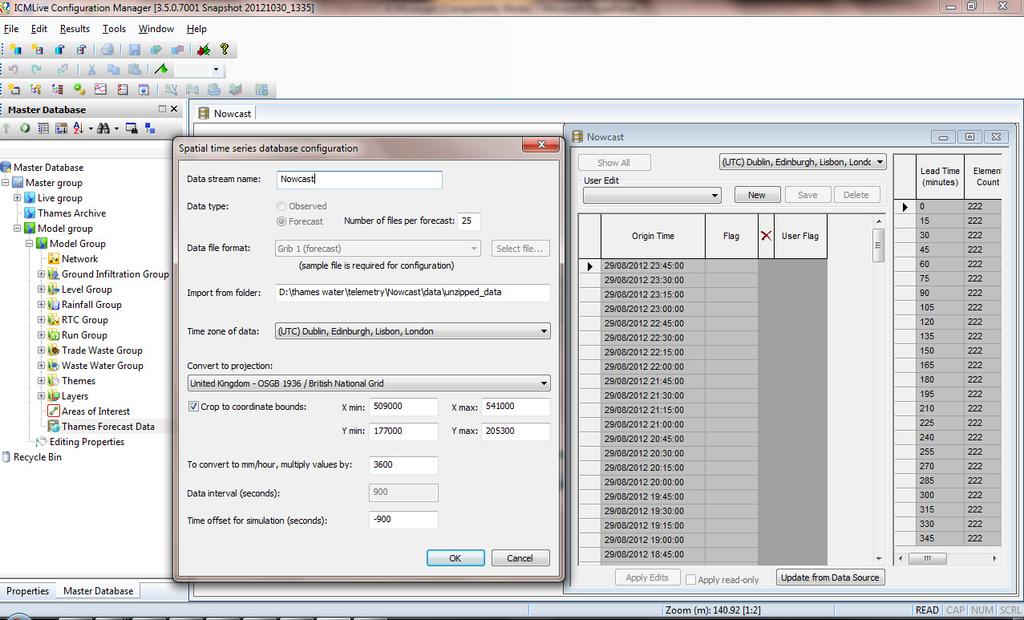
11 ICMLive - Rainfall

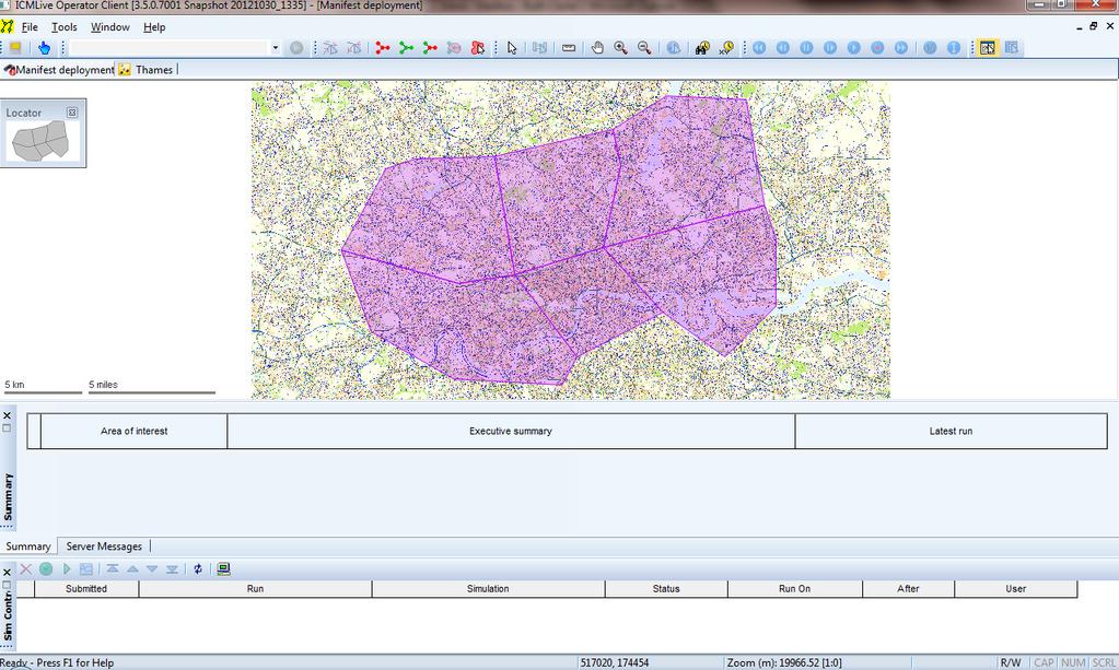
12 ICMLive Operator Client
13 ICMLive Functionality Automatic loading of forecast runs Triggered forecast frequency Built-in client using SMTP Multi-functional alerts You can alert on anything Observed, modelled and combinations Export of results to csv/sql/oracle What-if scenarios Skeletonised models can trigger detailed models
14 Benefits I Forecasting of system states Reduction in flood damages Reduction of risk to public, staff & contractors Reduction in numbers of CSO spills Real-time model and telemetry data Early identification of maintenance issues Improved understanding of network operation
15 Benefits II Operational management Schedule pump and gate operation Evaluate different control strategies Maximise the use of system storage Reduction in energy and CO2 costs Continuous simulation Continuous evaluation of existing and proposed systems using real-world inputs
16 Model Preparation and Simplification
17 Model preparation I Getting an ICM model into ICMLive is relatively straightforward. ICMLive is an extension of ICM Key tasks Convert event data into TSDBs Create TVD Connectors Develop alerts/actions There will be some IT tasks as well
18 Model preparation II Those IT tasks... Get IT involved early! Machines/Permissions/ /Data transfer Sourcing telemetry data Deciding key inputs Sourcing and prioritising forecast data You may have to adjust your model
19 ICM Modelling Modern approach is to add as much detail as possible to a model Small pipes Complex RTC Full 2D network Water courses But remember the four flood forecasting criteria.
20 TSDBs and Live Data
21 Rainfall Flow Temperature Quality Infiltration Snow Regulator Event Level
22 We re doing things better
23 What is a TSDB? Flow Level Rainfall Pump Settings Water Quality Velocity Infiltration Observ ed Radar Foreca st Radar Other Spatial Rainfal l
24
25 Live Data Sources
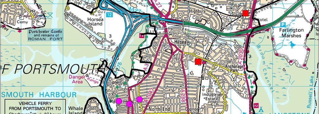
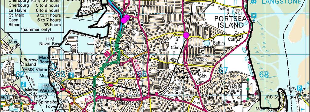
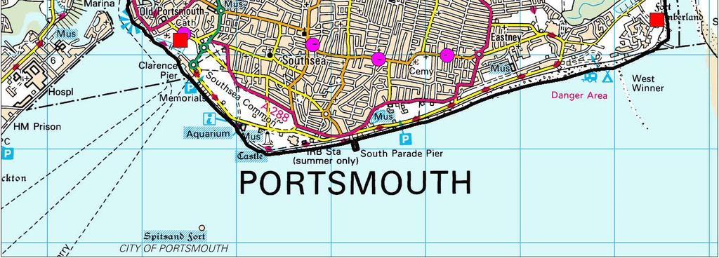
26 Sources Telemetry databases: Microsoft SQL Server Oracle ODBC PI ihistorian ClearSCADA Flat files CSV Batch CSV
27 Weather Feeds: Data Formats Grib 1 (observed and forecast) Grib 2 (observed and forecast) NetCDF (observed and forecast) NEXRAD (DPR) NIMROD (observed and forecast) Shapefile (observed and forecast) X-MP (on the spot and forecast) Furuno (observed and forecast)
28 Data Feeds Threshold Pressure > 50m Duration Pressure < 10m for 3hrs

29 Threshold Pressure > 50m Common terms NOW hindcast forecast CRITICAL floodlevel NON-CRITICAL floodlevel
30 Moveable assets: Internal Controls Pumps, gates, valves Observed settings revert to control rules into the future
31 Existing Users

32 Existing Users
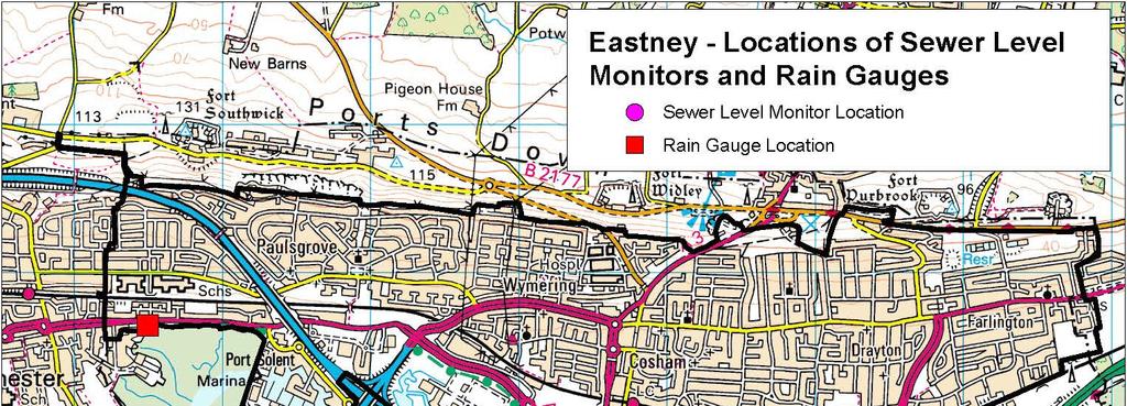
33 EASTNEY PUMP STATION
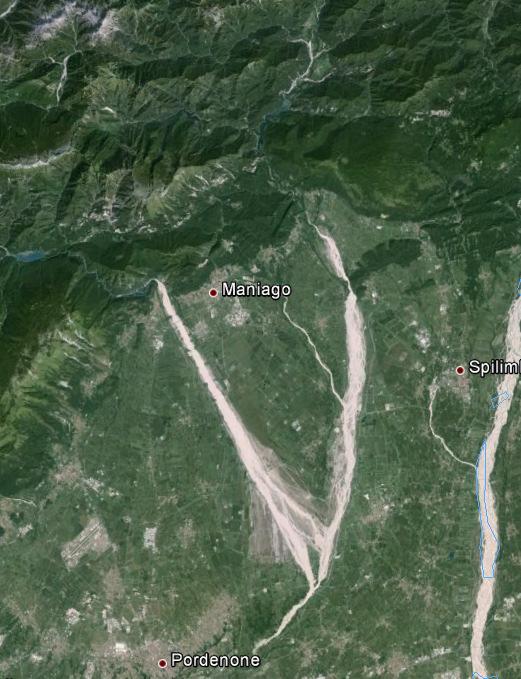
34 Eastney Project Background Project initiation 4D JV engaged Innovyze to build early warning system Hydraulic model developed by MWH using InfoWorks CS Operational system designed by Innovyze using ICMLive System goals Forecast water levels for flood forecasting Forecast pump operation Forecast flows to Fort Cumberland
35
36 System Overview Pumping Station located in Eastney Four large diesel pumps Two small diesel pumps modelled as a combined pump in IWCS Sister pumping station (four electric pumps) Pumping stations at Cosham, Drayton, Copnor ICMLive system used to combine rainfall radar and gauge data with level and pump information to provide warnings of pump operation and flows Operators able to change the pump settings in ICM model in order to improve levels of service
37 ICMLive - Eastney Pump Operation Fort Cumberland Flows Real time data Nowcast Telemetry 5 Rain gauges 9SLM Pump operation ICMLive Eastney hydraulic model Operational forecasts
38 Decision Support Forecasts run every fifteen minutes Forecast period 6 hours Critical results Observed/modelled levels Pump settings visible in map view Radar rainfall can be overlain Critical Points Eastney Pumping Station Long and short sea outfalls
39 RAVEDIS FLOOD FORECASTING
 Consultant: Beta Studio, Italy Guidance: HR Wallingford, with support from")
40 The problem How to manage river flows to optimise reservoir operation whilst minimising flooding at a major city downstream of Ravedis dam? Client: Consorzio di Bonfica (manages waterways of region) Consultant: Beta Studio, Italy Guidance: HR Wallingford, with support from Innovyze

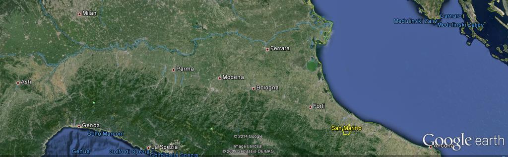
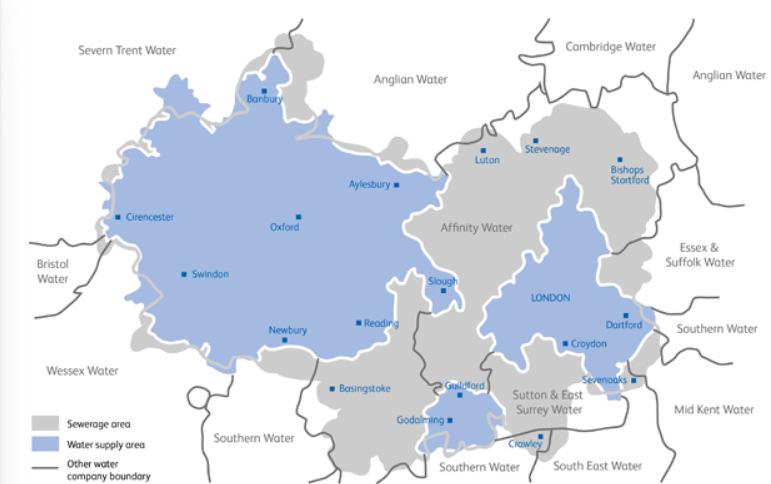
41 Project location


42 The flooding problem in Pordenone City of Pordenone Meduna river Noncello valley Pordenone community


43 Ravedis Dam Key structure in catchment Used for HEP Generation, Irrigation and Flood Control Balance of three uses
44 Catchment Modelling Upstream catchments modelled using PDM with snow melt inputs River modelled using InfoWorks ICM (1D model) Three outfall nodes along the river to model losses through gravels to ground water 1D Flood spreading
45 Forecasting System ICMLive used for the forecasting Key telemetry/input signals: Gauged rainfall Radar rainfall Gate operations at Ravedis Water levels

 COSMO-LAMI model Overall weather")

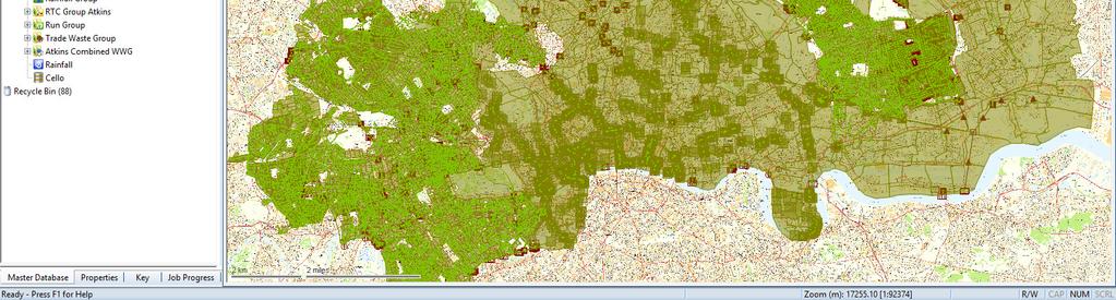
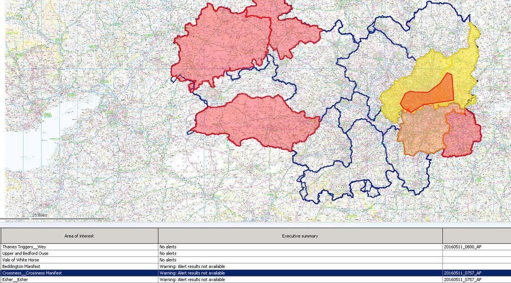
46 Forecast data Nowcast (3 to 5 hours) anticipate the prediction of peak flow optimise flood control Forecast (2 to 3 days) COSMO-LAMI model Overall weather state Mathematical model Advantages: Reduction in false alarms Longer lead times
47 Operational System Operational since 2014 Installed in Consorzio di Bonfica offices Runs hourly
48 THAMES WATER
49 Thames Water The original ICMLive system UK s largest water company Thames Valley, including London, Reading, Oxford, Luton 15 million customers Originally model design to cover the Beckton catchment (north London)
50
51 ICMLive Implementation Originally FloodWorks In place 2012 in time for the London Olympic No CSOs to the River Lea! Originally model design to cover the Beckton catchment (north London)
52 ICMLive Implementation System Summary Combines a very large InfoWorks ICM model with real time telemetry (level gauge) and radar rainfall data Run forecasts in real time Alerts generated where CSOs, flood events or results divergence occur alerts distributed to operations staff

53 Olympic Site
54 Olympic Implementation Thames Water tasked with having NO CSOs to the River Lea over the Olympic period FloodWorks system included as part of the Thames Water Olympic Control Room Fortunately the Olympic period was very dry!
55 Current Implementation Rolling out across the remaining catchments Hydrology runs every 30 minutes Hydraulic runs triggered when rainfall is detected.
56 Current Implementation
Richard Body (Innovyze), Ruth Clarke (Innovyze) and William Neale (Thames Water)
, Ruth Clarke (Innovyze) and William Neale (Thames Water)") Real-time Operational Modelling of Sewers: A Case Study Richard Body (Innovyze), Ruth Clarke (Innovyze) and William Neale (Thames Water) Keywords: Operational modelling, forecasting, hydraulic modelling,
Real-time Operational Modelling of Sewers: A Case Study Richard Body (Innovyze), Ruth Clarke (Innovyze) and William Neale (Thames Water) Keywords: Operational modelling, forecasting, hydraulic modelling,
Wales real time forecasting for fast responding rivers. Andy Wall Flood Forecasting Team Leader Environment Agency Wales
 Wales real time forecasting for fast responding rivers Andy Wall Flood Forecasting Team Leader Environment Agency Wales Flood risk & forecasting in Wales Fast responding rivers 220,000 properties at
Improved rainfall estimates and forecasts for urban hydrological applications
 Improved rainfall estimates and forecasts for urban hydrological applications Innovyze User Days - Drainage and Flooding User Group Wallingford, 20 th June 2013 Contents 1. Context 2. Radar rainfall processing
Presented at WaPUG Spring Meeting 1 st May 2001
 Presented at WaPUG Spring Meeting 1 st May 21 Author: Richard Allitt Richard Allitt Associates Ltd 111 Beech Hill Haywards Heath West Sussex RH16 3TS Tel & Fax (1444) 451552 1. INTRODUCTION The Flood Estimation
DEVELOPMENT OF A FORECAST EARLY WARNING SYSTEM ethekwini Municipality, Durban, RSA. Clint Chrystal, Natasha Ramdass, Mlondi Hlongwae
 DEVELOPMENT OF A FORECAST EARLY WARNING SYSTEM ethekwini Municipality, Durban, RSA Clint Chrystal, Natasha Ramdass, Mlondi Hlongwae LOCATION DETAILS AND BOUNDARIES ethekwini Municipal Area = 2297 km 2
Extending the use of Flood Modeller Pro towards operational forecasting with Delft-FEWS
 Extending the use of Flood Modeller Pro towards operational forecasting with Delft-FEWS Simone van Schijndel, Department Head Operational Water Management and Early Warning Intentionally blank The world
Modeling Great Britain s Flood Defenses. Flood Defense in Great Britain. By Dr. Yizhong Qu
 Modeling Great Britain s Flood Defenses AIRCurrents Editor s note: AIR launched its Inland Flood Model for Great Britain in December 2008. The hazard module captures the physical processes of rainfall-runoff
Hydrological Applications of Weather Radar
 Hydrological Applications of Weather Radar Summary of Findings and Conclusions from Survey distributed by the Inter-Agency Committee on the Hydrological Use of Weather Radar Prepared and published on behalf
Complete Weather Intelligence for Public Safety from DTN
 Complete Weather Intelligence for Public Safety from DTN September 2017 White Paper www.dtn.com / 1.800.610.0777 From flooding to tornados to severe winter storms, the threats to public safety from weather-related
Local Area Weather Radar (LAWR) System to Approve Drainage Systems Capacity Case Study from Egedal - Denmark
 System to Approve Drainage Systems Capacity Case Study from Egedal - Denmark") Local Area Weather Radar (LAWR) System to Approve Drainage Systems Capacity Case Study from Egedal - Denmark Authors Sabah Al-Shididi Henrik S. Andersen Frank Hjulskov Presenter Sabah Al-Shididi MSc Environmental
Local Area Weather Radar (LAWR) System to Approve Drainage Systems Capacity Case Study from Egedal - Denmark Authors Sabah Al-Shididi Henrik S. Andersen Frank Hjulskov Presenter Sabah Al-Shididi MSc Environmental
CWMS Modeling for Real-Time Water Management
 Hydrologic Engineering Center Training Course on CWMS Modeling for Real-Time Water Management August 2018 Davis, California The Corps Water Management System (CWMS) is a software and hardware system to
Leuven case study. International workshop & project meeting Leuven, April 2012
 Leuven case study International workshop & project meeting Leuven, 16-17 April 2012 Johan Van Assel (Aquafin) Laurens Cas Decloedt, Patrick Willems (KU Leuven) Raingain Project meeting 17/04/2012 - Aquafin
Flood Frequency Mapping using Multirun results from Infoworks RS applied to the river basin of the Yser, Belgium
 Flood Frequency Mapping using Multirun results from Infoworks RS applied to the river basin of the Yser, Belgium Ir. Sven Verbeke Aminal, division Water, Flemish Government, Belgium Introduction Aminal
On the use of radar rainfall estimates and nowcasts in an operational heavy rainfall warning service
 On the use of radar rainfall estimates and nowcasts in an operational heavy rainfall warning service Alan Seed, Ross Bunn, Aurora Bell Bureau of Meteorology Australia The Centre for Australian Weather
Flash Flood Guidance System On-going Enhancements
 Flash Flood Guidance System On-going Enhancements Hydrologic Research Center, USA Technical Developer SAOFFG Steering Committee Meeting 1 10-12 July 2017 Jakarta, INDONESIA Theresa M. Modrick Hansen, PhD
6/9/2014. Software Overview. System Overview
 Future Rainfall 6/9/2014 Curtis Beitel, PE, CFM, Anthony Henry and Wayne Tschirhart, PE, CFM, PMP TFMA Spring 2014 Conference Software Overview 2 Processes Hydrometric DB Event Manager Automatic Low =
Visualising and communicating probabilistic flow forecasts in The Netherlands
 Visualising and communicating probabilistic flow forecasts in The Netherlands Eric Sprokkereef Centre for Water Management Division Crisis Management & Information Supply 2-2-2009 Content The basins Forecasting
Mermaid. The most sophisticated marine operations planning software available.
 Mermaid The most sophisticated marine operations planning software available. Mojo Maritime / Marine economic risk management aid Mermaid : marine economic risk management aid The most sophisticated marine
CLIMATE CHANGE ADAPTATION BY MEANS OF PUBLIC PRIVATE PARTNERSHIP TO ESTABLISH EARLY WARNING SYSTEM
 CLIMATE CHANGE ADAPTATION BY MEANS OF PUBLIC PRIVATE PARTNERSHIP TO ESTABLISH EARLY WARNING SYSTEM By: Dr Mamadou Lamine BAH, National Director Direction Nationale de la Meteorologie (DNM), Guinea President,
12/07/2017. Flash Flood Warning Service, an advanced approach towards flood resilient cities Floodplain Management Association Conference, Newcastle
 12/07/2017 Worldwide problem: Flash Floods Flash Floods are a Global Problem Flash Flood Warning Service, an advanced approach towards flood resilient cities Floodplain Management Association Conference,
Next Generation Flood Forecasting and Warning System Evaluation and Work Plan Development
 Next Generation Flood Forecasting and Warning System Evaluation and Work Plan Development March 8, 2018 Nick Lorrain, CET Manager, Capital Projects Toronto and Region Conservation Authority nlorrain@trca.on.ca
Application of Real-Time Rainfall Information System to CSO control. 2 October 2011 Naruhito Funatsu METAWATER Co., Ltd.
 Application of Real-Time Rainfall Information System to CSO control 2 October 2011 Naruhito Funatsu METAWATER Co., Ltd. Presentation Points Objectives To verify the applicability of the real-time rainfall
BARON END-TO-END HYDROLOGICAL MODELING SOLUTION NOW AVAILABLE IN NEW BARON LYNX DISPLAY
 4930 Research Drive Huntsville, AL 35805 (256)-881-8811 www.baronweather.com FOR IMMEDIATE RELEASE BARON END-TO-END HYDROLOGICAL MODELING SOLUTION NOW AVAILABLE IN NEW BARON LYNX DISPLAY Powerful scientific
Regional Flash Flood Guidance and Early Warning System
 WMO Training for Trainers Workshop on Integrated approach to flash flood and flood risk management 24-28 October 2010 Kathmandu, Nepal Regional Flash Flood Guidance and Early Warning System Dr. W. E. Grabs
Aurora Bell*, Alan Seed, Ross Bunn, Bureau of Meteorology, Melbourne, Australia
 15B.1 RADAR RAINFALL ESTIMATES AND NOWCASTS: THE CHALLENGING ROAD FROM RESEARCH TO WARNINGS Aurora Bell*, Alan Seed, Ross Bunn, Bureau of Meteorology, Melbourne, Australia 1. Introduction Warnings are
Flood Forecasting Methodology in Alberta
 Flood Forecasting Methodology in Alberta Evan Friesenhan, M.Eng., P.Eng Alberta Environment and Sustainable Resource Development March 17, 2014 River Forecast Team Mandate To provide Albertans with information
Understanding Weather and Climate Risk. Matthew Perry Sharing an Uncertain World Conference The Geological Society, 13 July 2017
 Understanding Weather and Climate Risk Matthew Perry Sharing an Uncertain World Conference The Geological Society, 13 July 2017 What is risk in a weather and climate context? Hazard: something with the
The use of rainfall radar in flood warning. Holly Denning Flood Incident Management Team - Wessex
 The use of rainfall radar in flood warning Holly Denning Flood Incident Management Team - Wessex 1 Agenda h Objectives h Crewkerne and Shepton Mallet, Somerset 29 th May 2008 h Ringwood, Dorset 3 rd June
Leveraging GIS data and tools for maintaining hydraulic sewer models
 Leveraging GIS data and tools for maintaining hydraulic sewer models Ben Gamble & Joseph Koran Metropolitan Sewer District of Greater Cincinnati Carl C. Chan & Michael York CDM Smith Ben Gamble Senior
Comprehensive Winter Maintenance Management System BORRMA-web MDSS inside to increase Road Safety and Traffic Flow
 Thorsten Cypra 1 Comprehensive Winter Maintenance Management System BORRMA-web MDSS inside to increase Road Safety and Traffic Flow American Public Works Association (APWA) Monday, 04/14/2008 3:30 4:30
You Call That Good Data? How to Survive a Consent Decree Flow Monitoring Program
 Hampton Roads Sanitation District You Call That Good Data? How to Survive a Consent Decree Flow Monitoring Program September 2011 You Call That Good Data? How to Survive a Consent Decree Flow Monitoring
Pompton Lakes Dam Downstream Effects of the Floodgate Facility. Joseph Ruggeri Brian Cahill Michael Mak Andy Bonner
 Pompton Lakes Dam Downstream Effects of the Joseph Ruggeri Brian Cahill Michael Mak Andy Bonner ASFPM 2013: Overview Page 2 Overview Page 3 Overview Page 4 Overview Page 5 Overview - Historical Pompton
Flash flood forecasting and warning infrastructures of National Meteorology and Hydrological Services of Cambodia
 Development and Implementation of the South East Asia Flash Flood Guidance System (SEAFFGS) Ha Noi, Viet Nam, 20-23 November 2017 Flash flood forecasting and warning infrastructures of National Meteorology
Flood Forecasting Methodology in Alberta
 Flood Forecasting Methodology in Alberta Evan Friesenhan, M.Eng., P.Eng Alberta Environment and Sustainable Resource Development February 18, 2014 River Forecast Team Mandate To provide Albertans with
Rainwater storage facilities
 Rainwater storage facilities Development of facilities for target rainfall Planned discharge in pump drainage areas City Yokohama Kawasaki Total Discharge area Tsuzuki Kouhoku Hokubu Kase Planned discharge
Sensor networks and urban pluvial flood modelling in an urban catchment
 Environmental virtual observatories: managing catchments with wellies, sensors and smartphones Sensor networks and urban pluvial flood modelling in an urban catchment 28 th February 2013 Contents 1. Context
Forecasting Flood Risk at the Flood Forecasting Centre, UK. Delft-FEWS User Days David Price
 Forecasting Flood Risk at the Flood Forecasting Centre, UK Delft-FEWS User Days 2012 David Price Overview of the Flood Forecasting Centre (FFC) What is the FFC? Partnership between the Met Office and Environment
Flood Forecasting Methodology in Alberta
 Flood Forecasting Methodology in Alberta Colleen Walford, P.Eng Alberta Environment and Sustainable Resource Development March 24, 2014 River Forecast Team Mandate To provide Albertans with information
Climate Adaptation Challenges for Boston s Water and Sewer Systems
 National Association of Flood & Stormwater Management Agencies Climate Adaptation Challenges for Boston s Water and Sewer Systems John P Sullivan P.E. October 15,2014 Boston 1630 Boston 1630-2012 Boston
The University of Akron. William Troyer The Dr. Gary B. and Pamela S. Williams Honors College
 The University of Akron IdeaExchange@UAkron Honors Research Projects The Dr. Gary B. and Pamela S. Williams Honors College Spring 2018 Applying Control Logic to the End of the Ohio Canal Interceptor Tunnel
Hydrological forecasting and decision making in Australia
 Hydrological forecasting and decision making in Australia Justin Robinson, Jeff Perkins and Bruce Quig Bureau of Meteorology, Australia The Bureau's Hydrological Forecasting Services Seasonal Forecasts
C o p e r n i c u s E m e r g e n c y M a n a g e m e n t S e r v i c e f o r e c a s t i n g f l o o d s
 C o p e r n i c u s E m e r g e n c y M a n a g e m e n t S e r v i c e f o r e c a s t i n g f l o o d s Copernicus & Copernicus Services Copernicus EU Copernicus EU Copernicus EU www.copernicus.eu W
URBAS Prediction and management of flash floods in urban areas
 URBAS Prediction and management of flash floods in urban areas 1 Thomas Einfalt, Klaus Friedeheim, Andreas Wagner Project funded by the Federal Ministry of Education and Research BMBF (Germany) as a part
CSO Post-Construction Monitoring and Performance Assessment
 Massachusetts Water Resources Authority CSO Post-Construction Monitoring and Performance Assessment Jeremy R. Hall, Project Manager Operations/Engineering & Construction Wastewater Advisory Committee December
Report on the demonstration in Gliwice of enhanced real-time measuring and forecasting technologies for combined sewer systems (D 1.3.
 Report on the demonstration in Gliwice of enhanced real-time measuring and forecasting technologies for combined sewer systems (D 1.3.11) Demonstration Report Report on the demonstration in Gliwice of
A Cloud-Based Flood Warning System For Forecasting Impacts to Transportation Infrastructure Systems
 A Cloud-Based Flood Warning System For Forecasting Impacts to Transportation Infrastructure Systems Jon Goodall Associate Professor, Civil and Environmental Engineering Associate Director, Link Lab April
LOG_aLevel. Tsunami Warning System
 LOG_aLevel Tsunami Warning System General Acoustics e.k. Am Kiel-Kanal 1 24106 Kiel Germany Phone: +49 431 5 80 81 80 www.generalacoustics.com Info@generalacoustics.com LOG_aLevel Tsunami Warning System
IMPROVING ACCURACY, LEAD TIME AND CONTINGENCY IN FLUVIAL FLOOD FORECASTS TO ENHANCE EMERGENCY MANAGEMENT
 IMPROVING ACCURACY, LEAD TIME AND CONTINGENCY IN FLUVIAL FLOOD FORECASTS TO ENHANCE EMERGENCY MANAGEMENT Federico Groppa 1, Jon Wicks 2, Andy Barnes 3 1 Halcrow Group, Brisbane, QLD, groppaf@halcrow.com
IMS4 ARWIS. Airport Runway Weather Information System. Real-time data, forecasts and early warnings
 Airport Runway Weather Information System Real-time data, forecasts and early warnings Airport Runway Weather Information System FEATURES: Detection and prediction of runway conditions Alarms on hazardous
Climate change and natural disasters, Athens, Greece October 31, 2018
 Flood early warning systems: operational approaches and challenges Climate change and natural disasters, Athens, Greece October 31, 2018 Athens, October 31, 2018 Marco Borga University of Padova, Italy
MODERN TECHNOLOGIES IN HYDRO-METEOROLOGICAL INFORMATION SYSTEMS
 MODERN TECHNOLOGIES IN HYDRO-METEOROLOGICAL INFORMATION SYSTEMS MARK HEGGLI, INNOVATIVE HYDROLOGY CONSULTING METEOROLOGIST/HYDROLOGIST TO THE WORLD BANK AREAS OF TECHNOLOGY ADVANCEMENT RECENT TECHNOLOGY
Radar-raingauge data combination techniques: A revision and analysis of their suitability for urban hydrology
 9th International Conference on Urban Drainage Modelling Belgrade 2012 Radar-raingauge data combination techniques: A revision and analysis of their suitability for urban hydrology L. Wang, S. Ochoa, N.
Rainfall Prediction System for the CuaDat Dam Basin
 Workshop on Water Resources Management and Water-related Disaster Mitigation -innovative reservoir operation for flood risk mitigation- Rainfall Prediction System for the CuaDat Dam Basin Summary 1 In
Space for Smarter Government Programme
 Space for Smarter Government Programme Development of Operational National Satellite Imaging Flood Mapping Capability Project Number: 59287-454144 Web: http://www.spaceforsmartergovernment.uk/ Email: ssgp@sa.catapult.org.uk
The Civil Protection System of the Autonomous Region of Friuli Venezia Giulia (Italy)
") The Civil Protection System of the Autonomous Region of Friuli Venezia Giulia (Italy) Geol. Raffaele Lotto La Plata, November 2017 Friuli Venezia Giulia Autonomous Region Austria Pordenone Udine Gorizia
The Civil Protection System of the Autonomous Region of Friuli Venezia Giulia (Italy) Geol. Raffaele Lotto La Plata, November 2017 Friuli Venezia Giulia Autonomous Region Austria Pordenone Udine Gorizia
D. MATHEMATICAL MODEL AND SIMULATION
 D. MATHEMATICAL MODEL AND SIMULATION D - i TABLE OF CONTENTS D.1 Objective of Model Development... D - 1 D.2 Selection of Software... D - 1 D.3 General Steps of Simulation by MOUSE... D - 1 D.4 Cases of
Workshop on MCCOE Radar Meteorology /Climatology in Indonesia. Segel Ginting Wanny K. Adidarma
 Workshop on MCCOE Radar Meteorology /Climatology in Indonesia BPPT, 28 Februari 2013 JAKARTA FLOOD EARLY WARNING SYSTEM (J-FEWS) Segel Ginting Wanny K. Adidarma JCP (Joint Cooperation Program) Indonesia
United States Multi-Hazard Early Warning System
 United States Multi-Hazard Early Warning System Saving Lives Through Partnership Lynn Maximuk National Weather Service Director, Central Region Kansas City, Missouri America s s Weather Enterprise: Protecting
*Corresponding author address: Charles Barrere, Weather Decision Technologies, 1818 W Lindsey St, Norman, OK
 P13R.11 Hydrometeorological Decision Support System for the Lower Colorado River Authority *Charles A. Barrere, Jr. 1, Michael D. Eilts 1, and Beth Clarke 2 1 Weather Decision Technologies, Inc. Norman,
ENGINEERING HYDROLOGY
 ENGINEERING HYDROLOGY Prof. Rajesh Bhagat Asst. Professor Civil Engineering Department Yeshwantrao Chavan College Of Engineering Nagpur B. E. (Civil Engg.) M. Tech. (Enviro. Engg.) GCOE, Amravati VNIT,
National Public Weather and Warning Services in the Swaziland Meteorological Service Dennis S.Mkhonta /
 National Public Weather and Warning Services in the Swaziland Meteorological Service Dennis S.Mkhonta dennis.mkhonta@gmail.com / dennis@swazimet.gov.sz Introduction Swaziland s geographical position exposes
GeoSpatial Water Distribution, Sanitary Sewer and Stormwater Network Modeling
 2009 Bentley Systems, Incorporated GeoSpatial Water Distribution, Sanitary Sewer and Stormwater Network Modeling Angela Battisti, Gary Griffiths Bentley Systems Inc Presenter Profile Angela Battisti, CE,
Flood Risk Mapping and Forecasting in England
 Flood Risk Mapping and Forecasting in England Mark Franklin Environment Agency, England NORDESS Workshop on Risk Assessment and Acceptable Risk Outline Flood risk in England Who we are and how we work
Procurement Plan. II. Thresholds for Prior Review, Procurement Approaches and Methods
 I. General Plan 1. Project Information Country: Tanzania Project Name: Second Water Sector Support Project (WSSP II) Project ID: P150361 2. Project Agency: Ministry of Water and Irrigation Dar es Salaam
Instituto de Pesquisas Meteorológicas - IPMet Universidade Estadual Paulista - Unesp
 IPMET WEB GIS APPLICATION FOR SEVERE WEATHER ALERT AND DECISION SUPPORT Jaqueline Murakami Kokitsu Instituto de Pesquisas Meteorológicas - IPMet Universidade Estadual Paulista - Unesp IPMet/Unesp Meteorological
Tarbela Dam in Pakistan. Case study of reservoir sedimentation
 Tarbela Dam in Pakistan. HR Wallingford, Wallingford, UK Published in the proceedings of River Flow 2012, 5-7 September 2012 Abstract Reservoir sedimentation is a main concern in the Tarbela reservoir
Enabling Success in Enterprise Asset Management: Case Study for Developing and Integrating GIS with CMMS for a Large WWTP
 Enabling Success in Enterprise Asset Management: Case Study for Developing and Integrating GIS with CMMS for a Large WWTP Allison Blake, P.E. 1*, Matthew Jalbert, P.E. 2, Julia J. Hunt, P.E. 2, Mazen Kawasmi,
Jefferson Parish GIS Hurricane Response Review. From the information given by A.J. Tapie, GIS Manager of Jefferson Parish, the use of
 Neil Dixon and Ryan Ziegelbauer URPL 969 3/10/2006 Jefferson Parish GIS Hurricane Response Review From the information given by A.J. Tapie, GIS Manager of Jefferson Parish, the use of GIS in the Parish
Role of Arc GIS in developing Real Time and Forecasting Water Resource System ANMOL BHARDWAJ 1, ANIL VYAS 2 1
 Role of Arc GIS in developing Real Time and Forecasting Water Resource System ANMOL BHARDWAJ 1, ANIL VYAS 2 1 Project Associate, Indian Institute of Technology Roorkee 2 ADE National Hydrology Project,
TOOLS FOR RISK MANAGEMENT Related to climate change
 TOOLS FOR RISK MANAGEMENT Related to climate change copyright CONTENT 1 CLIMATE CHANGE AND ENVIRONMENTAL STUDIES 2 METHODS AND TOOLS DEVELOPED BY EGIS For infrastructures For urban areas For crisis management
Procurement Plan. II. Thresholds for Prior Review, Procurement Approaches and Methods
 I. General Plan 1. Project Information Country: Tanzania Project Name: Second Water Sector Support Project (WSSP II) Project ID: P150361 2. Project Agency: Ministry of Water and Irrigation Dar es Salaam
At the start of the talk will be a trivia question. Be prepared to write your answer.
 Operational hydrometeorological forecasting activities of the Australian Bureau of Meteorology Thomas Pagano At the start of the talk will be a trivia question. Be prepared to write your answer. http://scottbridle.com/
Measures Also Significant Factors of Flood Disaster Reduction
 Non-Structual Measures Also Significant Factors of Flood Disaster Reduction Babiaková Gabriela, Leškov ková Danica Slovak Hydrometeorological Institute, Bratislava Hydrological Forecasts and Warning Department
Use of Climate information in Disaster Risk Management in Zimbabwe
 Use of Climate information in Disaster Risk Management in Zimbabwe WMO Regional Technical Meeting & User/CONOPS Workshop, 28 th October 2015 Lameck Betera Department of Civil Protection Institutional Arrangements
CoCoRaHS. Community Collaborative Rain, Hail, & Snow Network. Ashley Wolf Meteorologist NWS Green Bay Northeast Wisconsin CoCoRaHS Coordinator
 CoCoRaHS Community Collaborative Rain, Hail, & Snow Network Ashley Wolf Meteorologist NWS Green Bay Northeast Wisconsin CoCoRaHS Coordinator What is CoCoRaHS Who, What, Where and Whys of CoCoRaHS What?
Challenges in providing effective flood forecasts and warnings
 Challenges in providing effective flood forecasts and warnings National Centre for Flood Research Inaugural Symposium Justin Robinson Bureau of Meteorology October 2018 Zero Lives Lost A key responsibility
Flood Map. National Dataset User Guide
 Flood Map National Dataset User Guide Version 1.1.5 20 th April 2006 Copyright Environment Agency 1 Contents 1.0 Record of amendment... 3 2.0 Introduction... 4 2.1 Description of the Flood Map datasets...4
South Asia Flash Flood Guidance System Operational Workshop (Step-4)
") South Asia Flash Flood Guidance System Operational Workshop (Step-4) (5 th to 7 th June 2018) Operational Flash Flood Forecasting and Early Warnings Capabilities in Bhutan (Sonam Tashi) Weather Forecaster
South Asia Flash Flood Guidance System Operational Workshop (Step-4) (5 th to 7 th June 2018) Operational Flash Flood Forecasting and Early Warnings Capabilities in Bhutan (Sonam Tashi) Weather Forecaster
Real-Time Flood Forecasting Modeling in Nashville, TN utilizing HEC-RTS
 Real-Time Flood Forecasting Modeling in Nashville, TN utilizing HEC-RTS Brantley Thames, P.E. Hydraulic Engineer, Water Resources Section Nashville District, USACE August 24, 2017 US Army Corps of Engineers
THE DEVELOPMENT OF RAIN-BASED URBAN FLOOD FORECASTING METHOD FOR RIVER MANAGEMENT PRACTICE USING X-MP RADAR OBSERVATION
 Research Paper Advances in River Engineering, JSCE, Vol.19, 2013,June THE DEVELOPMENT OF RAIN-BASED URBAN FLOOD FORECASTING METHOD FOR RIVER MANAGEMENT PRACTICE USING X-MP RADAR OBSERVATION Seongsim YOON
CLICK HERE TO KNOW MORE
 CLICK HERE TO KNOW MORE Integrating GIS data for Water Distribution Modeling Case Study: General Directorate of Water Eng. Atif Karrani - GIS Manager karrani@sewa.gov.ae Agenda Introduction Enterprise
Flood Forecasting in Bangladesh
 Flood Forecasting in Bangladesh Types of Flood ing Flood ing can be divided into two categories: Flood ing in the rivers caused by upstream rise of river stage as well as rainfall in the basin. Overland
Steering Committee on Global Flash Flood Guidance 29 November 2016, Inter-Continental Hotel, Phnom Penh. Cambodia National Weather Services
 Steering Committee on Global Flash Flood Guidance 29 November 2016, Inter-Continental Hotel, Phnom Penh Cambodia National Weather Services Activities and Responsibilities of Research and Flood Forecasting
Severe Weather Watches, Advisories & Warnings
 Severe Weather Watches, Advisories & Warnings Tornado Watch Issued by the Storm Prediction Center when conditions are favorable for the development of severe thunderstorms and tornadoes over a larger-scale
Improving global coastal inundation forecasting WMO Panel, UR2014, London, 2 July 2014
 Improving global coastal inundation forecasting WMO Panel, UR2014, London, 2 July 2014 Cyclone Sidr, November 2007 Hurricane Katrina, 2005 Prof. Kevin Horsburgh Head of marine physics, UK National Oceanography
FLOOD FORECAST MAPPING SANS MODELLING
 FLOOD FORECAST MAPPING SANS MODELLING C Smythe 1, G Newell 1, C Druery 2 1 Sunshine Coast Council, Nambour, QLD 2 WorleyParsons, Sydney, NSW Abstract The 2012 Queensland Floods Commission of Inquiry recommendations
Ridracoli Dam: surveillance and safety evaluation reported on internet page
 Ridracoli Dam: surveillance and safety evaluation reported on internet page P.P. MARINI; P. BALDONI; F. FARINA; F. CORTEZZI - Romagna Acque, Forlì, Italy A. MASERA - Enel.Hydro, ISMES Division, Bergamo,
FLORA: FLood estimation and forecast in complex Orographic areas for Risk mitigation in the Alpine space
 Natural Risk Management in a changing climate: Experiences in Adaptation Strategies from some European Projekts Milano - December 14 th, 2011 FLORA: FLood estimation and forecast in complex Orographic
Operational Perspectives on Hydrologic Model Data Assimilation
 Operational Perspectives on Hydrologic Model Data Assimilation Rob Hartman Hydrologist in Charge NOAA / National Weather Service California-Nevada River Forecast Center Sacramento, CA USA Outline Operational
ÖBB Natural Hazard Management
 ÖBB Natural Hazard Management Management of Weather Events in the Austrian Federal Railways MOWE-IT, Brussels 17 th of September 2013 DI Günther Kundela Integrated Track Management Integration Technic
Quantifying model uncertainty in the simulation of sewer overflow volume
 Quantifying model uncertainty in the simulation of sewer overflow volume Ambuj Sriwastava Marie Curie Early Stage Researcher, University of Sheffield This project has received funding from the European
INTEGRATION OF WATER INFORMATION AT A REGIONAL SCALE.
 INTEGRATION OF WATER INFORMATION AT A REGIONAL SCALE. Xabier Velasco Echeverría, Pablo Echamendi Lorente, Jesús Francés Iribarren. Trabajos Catastrales, S.A. Ctra del Sadar s/n - El Sario Building 31006
San Antonio River Authority. San Antonio River Authority Floodworks implementation in the San Antonio River Basin. Nefi Garza, PE, CFM
 San Antonio River Authority Floodworks implementation in the San Antonio River Basin Nefi Garza, PE, CFM San Antonio River Authority Michael Crenshaw, PE, CFM Anthony J. Henry Wallingford Software, Inc
Caribbean Early Warning System Workshop
 Caribbean Early Warning System Workshop Hamonization in Existing EWS April 14-16, 2016 Presenter: Shawn Boyce Caribbean Institute for Meteorology and Hydrology Husbands, St. James Barbados Background Between
SECTION II Hydrological risk
 Chapter 3 Understanding disaster risk: hazard related risk issues SECTION II Hydrological risk Peter Salamon Coordinating lead author Hannah Cloke Lead author 3.4 Giuliano di Baldassarre Owen Landeg Florian
StreamStats: Delivering Streamflow Information to the Public. By Kernell Ries
 StreamStats: Delivering Streamflow Information to the Public By Kernell Ries U.S. Department of the Interior U.S. Geological Survey MD-DE-DC District 410-238-4317 kries@usgs.gov StreamStats Web Application
VINCENT COOPER Flood Hazard Mapping Consultant
 FLOOD HAZARD MAPPING OF GRENADA FINAL REPORT (NON-TECHNICAL) By VINCENT COOPER Flood Hazard Mapping Consultant For the Caribbean Development Bank January, 2006 TABLE OF CONTENTS INTRODUCTION 1 METHODOLOGY
Results of Intensity-Duration- Frequency Analysis for Precipitation and Runoff under Changing Climate
 Results of Intensity-Duration- Frequency Analysis for Precipitation and Runoff under Changing Climate Supporting Casco Bay Region Climate Change Adaptation RRAP Eugene Yan, Alissa Jared, Julia Pierce,
Towards a probabilistic hydrological forecasting and data assimilation system. Henrik Madsen DHI, Denmark
 Towards a probabilistic hydrological forecasting and data assimilation system Henrik Madsen DHI, Denmark Outline Hydrological forecasting Data assimilation framework Data assimilation experiments Concluding
MEGACITIES AND DISASTER RISK - THE CASE OF MUMBAI
 Municipal Corporation of Greater Mumbai, India MEGACITIES AND DISASTER RISK - THE CASE OF MUMBAI Presentation by S S KSHATRIYA Municipal Commissioner MUMBAI Largest city in India 6 th Largest metropolis