Current capabilities and limitations of satellite monitoring and modeling forecasting of volcanic clouds: and example of Eyjafjallaj
|
|
|
- Ferdinand Bruce
- 5 years ago
- Views:
Transcription

1 Current capabilities and limitations of satellite monitoring and modeling forecasting of volcanic clouds: and example of Eyjafjallaj fjallajökull eruption (pronounced EYE-a-fyat fyat-la-jo-kotl) N. Krotkov 1, K. Yang 1, S. Carn 2, A. Krueger 1, G. Vicente 3, E. Hughes 3, P. Colarko 6, G. Morris 4, C. Seftor 5, J. Joiner 6, R. Kahn 6, M. Pavolonis 7 1 Univ. Maryland, Baltimore County GEST (UMBC), 2 Michigan Tech. Univ. 3 NOAA, 4 Valparaiso Univ., 5 SSAI, 6 NASA Goddard, 7 NOAA and Univ. Wisconsin

2 90s: Volcanic ash (UV and IR) and SO 2 (UV) UV: SO2 IR: T11-T12µm UV: AI Thermal IR split window technique (BTD= T11 - T12 < 0 ) technique was developed to retrieve ash mass loading and particle sizes and applied to NOAA AVHRR satellites Pattern recognition techniques were applied Geostationary GOES data UV SO 2 and aerosol index AI retrievals were pioneered at NASA Goddard using the Total Ozone Mapping Spectrometer (TOMS) Geostationary VolCam was selected as a backup ESSP mission behind CloudSat and CALIPSO (not flown)
 - ash height and opt.prop MODIS (Terra, Aqua) - SO 2, ash, sulfate AIRS - UTLS SO 2, aerosols, SO 2 profile?")
3 2010: NASA EOS assets for volcanic clouds studies OMI - SO 2, aerosols, BrO TES - SO 2, HCl MLS - strat. SO 2, HCl MISR ( Terra ) - ash height and opt.prop MODIS (Terra, Aqua) - SO 2, ash, sulfate AIRS - UTLS SO 2, aerosols, SO 2 profile? CALIPSO - cloud height, aerosol type

 and microphysical models of ash (andesite) are used to retrieve ash height, mass loading, and")

4 2010: NOAA IR algorithm for volcanic ash Ash Height Retrieved ash heights (white circles) Mass Loading Effective Radius Infrared effective absorption optical depth ratios are used to identify volcanic ash pixels (Pavolonis, 2010). Infrared measurements (11, 12, and 13.3 µm) and microphysical models of ash (andesite) are used to retrieve ash height, mass loading, and effective particle radius in an optimal estimation framework. While the volcanic ash detection and retrieval algorithm works best on SEVIRI, MODIS and GOES-R, it can be applied to GOES, MTSAT, FY2C, and AVHRR using a bi-spectral technique. Mike Pavolonis


5 4/15/2010, 12:00 UTC MSG/SEVIRI IR ash height NEW: OMI SO 2 height OMI operational: AI and SO 2
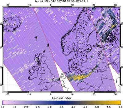
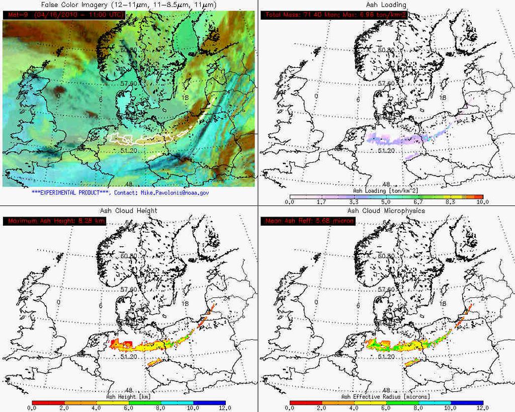
6 4/16/2010, 11:00 UTC

7 4/17/2010, 13:00 UTC ASH


8 4/19/2010, 13:00 UTC Terra MODIS image at 12:50 UTC. MISR-Derived Ash Plume Aerosol Amount & Properties

9 NOAA OMI volcanic near-real real-time (NRT) web site This application of NASA data was vision of Arlin Krueger Iceland and North Europe sectors added at 1:00 PM April 15

10 SO 2 Eyjafjallajokull volcano, May 5 OMI SO 2

11 OMI Field-of View blockage OMI Reflectivity
 Eyjafjallajokull volcano, May6 OMI")
12 Aerosol Index (ash) Eyjafjallajokull volcano, May6 OMI AI


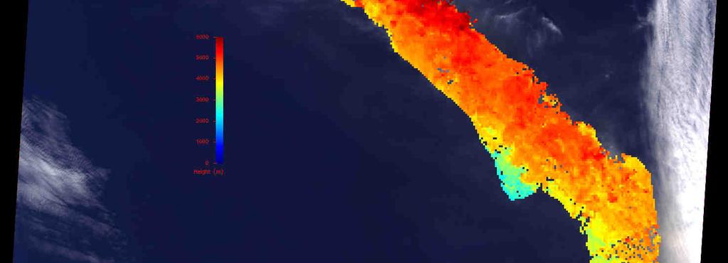

13 5/7/2010, 12:00 UTC km MISR Stereo-Derived Ash Plume Heights
14 Parcel Modeling: volcanic source Goddard Kinematic Trajectory Model [Mark Schoeberl ] Clusters of parcels emitted at volcano location Injections from km on April 14 QuickTime and a decompressor are needed to see this picture. Injections from km on April 15 Colors indicate parcel altitude KTM simulation courtesy of Gary Morris, Valparaiso Uni
15 Parcel Modeling: height PUFF model drives clusters of parcels with NOAA GFS winds estimation April 15 OMI AI PUFF MODEL Plume base height of 2 km better matches trailing Western edge 2 km Plume base height of 9 km better matches leading Eastern edge Conclusion: Early eruption Although at these 8-10 parcel km followed models are by useful low to altitude understand ash emissions plume structure, they cannot provide much quantitative information. 9 km Puff Simulation courtesy of Eric Hughes, ESSIC/ NOAA

16 Model Mass concentration Initialization Spatial extent Plume injection height Particle size distribution Composition (e.g. ash vs. sulfate) Meteorology MISR visible image (courtesy of NASA Earth Observatory Web Site)
17 Ash modeling with GEOS-5 Goddard Earth Observing System global climate model and data assimilation system. Ash uses a dust-like particle size distribution QuickTime and a H.264 decompressor are needed to see this picture. SO 2 and Ash emissions are: - 10 on April 14-1 on subsequent days simulation courtesy of Peter Colarko Injection height: km on April km on subsequent days
18 April 15 MODIS Aqua AOT OMI Aerosol Index Simulated ash not in OMI observations. Wrong injection height?
19 April 16 MODIS Aqua True Color OMI Aerosol Index Coincidence of narrow ash band. Obscured by clouds in MODIS, but clearly evident in OMI AI.
20 Road Forward Models need ingesting satellite data operationally in real time Refine ash module in models Measure ash samples for refractive index (UV to IR), size and shape distributions Use backward trajectories to estimate heights of volcanic clouds and develop satellite techniques for direct ash/so2 height measurements Realtime: would need short turnaround of satellite obs of height, location, and amount of material
21 Going Forward: OMI direct broadcast of SO 2 and AI via Finnish Meteorol.. Inst. Very Fast Delivery system Sodankylä satellite downlink station receives OMI Direct Broadcast data Fast processing:15 min. for O 3 and UV products High latitude site: ~3-5 orbits/day Action Items: Add SO 2 and AI to distribution Push for release of software to process data at other sites Sodankylä
A-Train observations of the 2010 eruption of Eyjafjallajökull volcano (Iceland)
") A-Train observations of the 2010 eruption of Eyjafjallajökull volcano (Iceland) S.A. Carn 1, N.A. Krotkov 2, K. Yang 2, A.J. Prata 3 1. Michigan Technological University, Houghton, MI, USA 2. GEST Center,
A-Train observations of the 2010 eruption of Eyjafjallajökull volcano (Iceland) S.A. Carn 1, N.A. Krotkov 2, K. Yang 2, A.J. Prata 3 1. Michigan Technological University, Houghton, MI, USA 2. GEST Center,
Incorporating Volcanic Eruptions into Near Real time Aerosol Forecasts
 Incorporating Volcanic Eruptions into Near Real time Aerosol Forecasts Eric Hughes 1 Nick Krotkov 2 Arlindo Da Silva 2 Peter Colarco 2 (1) University of MD Department of Atmospheric and Oceanic Sciences
Development of a System for Quantitatively Analyzing Volcanic Clouds
 Development of a System for Quantitatively Analyzing Volcanic Clouds Michael Pavolonis (NOAA/NESDIS/STAR) Justin Sieglaff and John Cintineo (UW-CIMSS) Marco Fulle - www.stromboli.net 2 nd IUGG-WMO Workshop
DIFFERING REGIONAL CAPABILITIES IN SATELLITE-BASED VOLCANIC ASH CLOUD DETECTION
 Prepared by NOAA Agenda Item: II/8 Discussed in WGII DIFFERING REGIONAL CAPABILITIES IN SATELLITE-BASED VOLCANIC ASH CLOUD DETECTION The GOES-R AWG is responsible for the developing the algorithms that
PHEOS - Weather, Climate, Air Quality
 Aerosol & cloud remote sensing over the Arctic : perspectives for the PHEMOS and meteorological imager payloads on the PCW mission Norm O Neill, Auromeet Saha, U. de Sherbrooke Chris E. Sioris, Jack McConnell,
Monitoring trace gas emissions and transport with Aura and the A-Train
 Monitoring trace gas emissions and transport with Aura and the A-Train Simon Carn Dept. of Geological and Mining Engineering, Michigan Technological University, Houghton, MI Aura (2004-) OMI - SO 2, NO
Near real-time monitoring of the April-May 2010 Eyjafjöll s ash cloud
 Near real-time monitoring of the April-May 2010 Eyjafjöll s ash cloud Labazuy P. and the HotVolc Team Observatoire de Physique du Globe de Clermont-Ferrand, CNRS, Université Blaise Pascal 13th International
Satellite observation of atmospheric dust
 Satellite observation of atmospheric dust Taichu Y. Tanaka Meteorological Research Institute, Japan Meteorological Agency 11 April 2017, SDS WAS: Dust observation and modeling @WMO, Geneva Dust observations
Eyja volcanic ash retrievals by using MODIS data
 INGV Eyja volcanic ash retrievals by using MODIS data S. Corradini, L. Merucci, A. Piscini Remote Sensing Group INGV (Rome) ESRIN May 26-27, 2010 Outline Ash retrieval algorithms in the TIR spectral range
Lecture 4b: Meteorological Satellites and Instruments. Acknowledgement: Dr. S. Kidder at Colorado State Univ.
 Lecture 4b: Meteorological Satellites and Instruments Acknowledgement: Dr. S. Kidder at Colorado State Univ. US Geostationary satellites - GOES (Geostationary Operational Environmental Satellites) US
Satellite Data For Applications: Aviation/Volcanic Ash. Richard Eckman NASA 27 May 2013
 Satellite Data For Applications: Aviation/Volcanic Ash Richard Eckman NASA 27 May 2013 Background Following the unprecedented disruption to aviation by the recent eruptions of Eyjafjallajökull and Grímsvötn
Advantageous GOES IR results for ash mapping at high latitudes: Cleveland eruptions 2001
 GEOPHYSICAL RESEARCH LETTERS, VOL. 32, L02305, doi:10.1029/2004gl021651, 2005 Advantageous GOES IR results for ash mapping at high latitudes: Cleveland eruptions 2001 Yingxin Gu, 1 William I. Rose, 1 David
Instrumentation planned for MetOp-SG
 Instrumentation planned for MetOp-SG Bill Bell Satellite Radiance Assimilation Group Met Office Crown copyright Met Office Outline Background - the MetOp-SG programme The MetOp-SG instruments Summary Acknowledgements:
The 2010 Eyjafjallajökull eruption: overview and OMI observations. Simon A. Carn Michigan Technological University, Houghton, MI, USA
 The 2010 Eyjafjallajökull eruption: overview and OMI observations Simon A. Carn Michigan Technological University, Houghton, MI, USA Global air routes and potentially active volcanoes Map courtesy of F.
Development of volcanic ash product for the next-generation Japanese Geostationary Meteorological Satellite Himawari-8
 Development of volcanic ash product for the next-generation Japanese Geostationary Meteorological Satellite Himawari-8 Hiroaki Tsuchiyama 1, Yukio Kurihara 1, Kazuhiko Masuda 2 (1) Japan Meteorological
Remote Detection and Monitoring of Volcanic Eruptions in the East African Rift
 Remote Detection and Monitoring of Volcanic Eruptions in the East African Rift Simon Carn 1, David Fee 2, Fred Prata 3 1 Department of Geological and Mining Engineering and Sciences, Michigan Technological
University of Bristol - Explore Bristol Research
 Prata, F., Woodhouse, M. J., Huppert, H. E., Prata, A., Thordarson, TH., & Carn, S. A. (2017). Atmospheric processes affecting the separation of volcanic ash and SO2 in volcanic eruptions: Inferences from
The identification and tracking of volcanic ash using the Meteosat Second Generation (MSG) Spinning Enhanced Visible and Infrared Imager (SEVIRI)
 Spinning Enhanced Visible and Infrared Imager (SEVIRI)") doi:10.5194/amt-7-581-2014 Author(s) 2014. CC Attribution 3.0 License. Atmospheric Measurement Techniques Open Access The identification and tracking of volcanic ash using the Meteosat Second Generation
doi:10.5194/amt-7-581-2014 Author(s) 2014. CC Attribution 3.0 License. Atmospheric Measurement Techniques Open Access The identification and tracking of volcanic ash using the Meteosat Second Generation
Volcanic plume modelling and assimilation with the global MACC system (with emphasis on SO 2 )
") Volcanic plume modelling and assimilation with the global MACC system (with emphasis on SO 2 ) Johannes Flemming, Antje Inness, Angela Benedetti & Jean-Jacques Morcrette Introduction How can we use timely
Volcanic plume modelling and assimilation with the global MACC system (with emphasis on SO 2 ) Johannes Flemming, Antje Inness, Angela Benedetti & Jean-Jacques Morcrette Introduction How can we use timely
Dispersion modelling and warnings for volcanic ash in the Australian Region
 Dispersion modelling and warnings for volcanic ash in the Australian Region R Potts, R Dare, E Jansons, C Lucas, A Tupper, M Zidikheri The Centre for Australian Weather and Climate Research A partnership
Volcanic ash retrieval at Mt. Etna using Avhrr and Modis data
 Volcanic ash retrieval at Mt. Etna using Avhrr and Modis data Claudia Spinetti* a, Stefano Corradini a, Maria F. Buongiorno a a Istituto Nazionale di Geofisica e Vulcanologia, via di Vigna Murata, 605
P3.24 EVALUATION OF MODERATE-RESOLUTION IMAGING SPECTRORADIOMETER (MODIS) SHORTWAVE INFRARED BANDS FOR OPTIMUM NIGHTTIME FOG DETECTION
 SHORTWAVE INFRARED BANDS FOR OPTIMUM NIGHTTIME FOG DETECTION") P3.24 EVALUATION OF MODERATE-RESOLUTION IMAGING SPECTRORADIOMETER (MODIS) SHORTWAVE INFRARED BANDS FOR OPTIMUM NIGHTTIME FOG DETECTION 1. INTRODUCTION Gary P. Ellrod * NOAA/NESDIS/ORA Camp Springs, MD
P3.24 EVALUATION OF MODERATE-RESOLUTION IMAGING SPECTRORADIOMETER (MODIS) SHORTWAVE INFRARED BANDS FOR OPTIMUM NIGHTTIME FOG DETECTION 1. INTRODUCTION Gary P. Ellrod * NOAA/NESDIS/ORA Camp Springs, MD
Sensitivity Study of the MODIS Cloud Top Property
 Sensitivity Study of the MODIS Cloud Top Property Algorithm to CO 2 Spectral Response Functions Hong Zhang a*, Richard Frey a and Paul Menzel b a Cooperative Institute for Meteorological Satellite Studies,
On the Satellite Determination of Multilayered Multiphase Cloud Properties. Science Systems and Applications, Inc., Hampton, Virginia 2
 JP1.10 On the Satellite Determination of Multilayered Multiphase Cloud Properties Fu-Lung Chang 1 *, Patrick Minnis 2, Sunny Sun-Mack 1, Louis Nguyen 1, Yan Chen 2 1 Science Systems and Applications, Inc.,
Satellite Constraints on Arctic-region Airborne Particles Ralph Kahn NASA Goddard Space Flight Center
 Satellite Constraints on Arctic-region Airborne Particles Ralph Kahn NASA Goddard Space Flight Center Sea of Okhotsk, MODIS image Feb. 6, 2007, NASA Earth Observatory Arctic Aerosol Remote Sensing Overview
NOAA s National Weather Service VAAC Anchorage. Don Moore
 NOAA s National Weather Service VAAC Anchorage Don Moore VAAC Best Practices Workshop May 2015 Volcanic Eruptions Volcanic Eruptions Volcanic Eruptions VAAC Anchorage and Alaska Aviation Weather Unit (AAWU)
8.13 A FIRST LOOK AT VOLCANIC ASH DETECTION IN THE GOES-12 ERA. Gary P. Ellrod * Office of Research and Applications (NOAA/NESDIS), Camp Springs, MD
, Camp Springs, MD") 8.13 A FIRST LOOK AT VOLCANIC ASH DETECTION IN THE GOES-12 ERA Gary P. Ellrod * Office of Research and Applications (NOAA/NESDIS), Camp Springs, MD Anthony J. Schreiner Cooperative Institute for Meteorological
8.13 A FIRST LOOK AT VOLCANIC ASH DETECTION IN THE GOES-12 ERA Gary P. Ellrod * Office of Research and Applications (NOAA/NESDIS), Camp Springs, MD Anthony J. Schreiner Cooperative Institute for Meteorological
The Eyjafjallajokull Volcanic Ash Cloud and its Effects on Scottish Air Quality. Update 06 May 2010
 The Eyjafjallajokull Volcanic Ash Cloud and its Effects on Scottish Air Quality. Update 06 May 2010 The volcanic ash cloud from the Eyjafjallakull volcano once again grounded flights from Scottish airports
Airborne High Spectral Resolution Lidar Aerosol Measurements and Comparisons with GEOS-5 Model
 Airborne High Spectral Resolution Lidar Aerosol Measurements and Comparisons with GEOS-5 Model Richard Ferrare, Chris Hostetler, John Hair, Anthony Cook, David Harper, Mike Obland, Ray Rogers, Sharon Burton,
The CEOS Atmospheric Composition Constellation (ACC) An Example of an Integrated Earth Observing System for GEOSS
 An Example of an Integrated Earth Observing System for GEOSS") The CEOS Atmospheric Composition Constellation (ACC) An Example of an Integrated Earth Observing System for GEOSS Presentation Authors: E. Hilsenrath NASA, C. Zehner ESA, J. Langen ESA, J. Fishman NASA
The CEOS Atmospheric Composition Constellation (ACC) An Example of an Integrated Earth Observing System for GEOSS Presentation Authors: E. Hilsenrath NASA, C. Zehner ESA, J. Langen ESA, J. Fishman NASA
FUTURE PLAN AND RECENT ACTIVITIES FOR THE JAPANESE FOLLOW-ON GEOSTATIONARY METEOROLOGICAL SATELLITE HIMAWARI-8/9
 FUTURE PLAN AND RECENT ACTIVITIES FOR THE JAPANESE FOLLOW-ON GEOSTATIONARY METEOROLOGICAL SATELLITE HIMAWARI-8/9 Toshiyuki Kurino Japan Meteorological Agency, 1-3-4 Otemachi Chiyodaku, Tokyo 100-8122,
Application of Aura/OMI PBL SO 2 product for estimating SO 2 emissions and future enhancements from new satellite missions
 Application of Aura/OMI PBL SO 2 product for estimating SO 2 emissions and future enhancements from new satellite missions 1 N. Krotkov, 2 V. Fioletov, 3,1 K. Yang, 4,1 Can Li, 3 R. Dickerson & Aura/OMI
Recommendation proposed: CGMS-39 WGII to take note.
 Prepared by EUMETSAT Agenda Item: G.II/8 Discussed in WGII EUM REPORT ON CAPABILITIES AND PLANS TO SUPPORT VOLCANIC ASH MONITORING In response to CGMS action WGII 38.31: CGMS satellite operators are invited
Influence of Clouds and Aerosols on the Earth s Radiation Budget Using Clouds and the Earth s Radiant Energy System (CERES) Measurements
 Measurements") Influence of Clouds and Aerosols on the Earth s Radiation Budget Using Clouds and the Earth s Radiant Energy System (CERES) Measurements Norman G. Loeb Hampton University/NASA Langley Research Center Bruce
Influence of Clouds and Aerosols on the Earth s Radiation Budget Using Clouds and the Earth s Radiant Energy System (CERES) Measurements Norman G. Loeb Hampton University/NASA Langley Research Center Bruce
Impact of NASA EOS data on the scientific literature: 16 years of published research results from Terra, Aqua, Aura, and Aquarius
 Impact of NASA EOS data on the scientific literature: 16 years of published research results from Terra, Aqua, Aura, and Aquarius Gene R. Major NASA Goddard Library Nebulous Connections April 4, 2017 RESACs/RA
Updates to the IMAPP AIRS Utility Software
 SPACE SCIENCE AND ENGINEERING CENTER Updates to the IMAPP AIRS Utility Software Elisabeth Weisz, Hung-Lung Huang and Kathy Strabala Cooperative Institute for Meteorological Satellite Studies Space Science
Mike Fromm, Naval Research Laboratory Washington, DC
 a b c Mike Fromm, Naval Research Laboratory Washington, DC d Particlelarly Interesting Science: the Meaning, Marvels and Mysteries of Pyrocumulonimbus Grimsvötn (Iceland) volcano June 2011 Warm Fire (Arizona)
The potential impact of ozone sensitive data from MTG-IRS
 The potential impact of ozone sensitive data from MTG-IRS R. Dragani, C. Lupu, C. Peubey, and T. McNally ECMWF rossana.dragani@ecmwf.int ECMWF May 24, 2017 The MTG IRS Long-Wave InfraRed band O 3 Can the
A new perspective on aerosol direct radiative effects in South Atlantic and Southern Africa
 A new perspective on aerosol direct radiative effects in South Atlantic and Southern Africa Ian Chang and Sundar A. Christopher Department of Atmospheric Science University of Alabama in Huntsville, U.S.A.
Single footprint sounding, surface emissivity and cloud property retrievals from hyperspectral infrared radiances under all sky conditions
 Single footprint sounding, surface emissivity and cloud property retrievals from hyperspectral infrared radiances under all sky conditions Jun Li @, Elisabeth Weisz @, Jinlong Li @, Allen Huang @, Chian-Yi
APPLICATION OF CCNY LIDAR AND CEILOMETERS TO THE STUDY OF AEROSOL TRANSPORT AND PM2.5 MONITORING
 P1.14 APPLICATION OF CCNY LIDAR AND CEILOMETERS TO THE STUDY OF AEROSOL TRANSPORT AND PM2.5 MONITORING Leona A. Charles*, Shuki Chaw, Viviana Vladutescu, Yonghua Wu, Fred Moshary, Barry Gross, Stanley
Usage of McIDAS V with GOES R AWG products
 McIDAS User Group Meeting, October 25-27, 2010, Madison, WI Usage of McIDAS V with GOES R AWG products William Straka III UW/CIMSS Madison, Wisconsin, USA With help from Tom Rink (CIMSS/), Tom Achtor (CIMSS/),
McIDAS Activities Within The NASA Langley Research Center Clouds And Radiation Group
 McIDAS Activities Within The NASA Langley Research Center Clouds And Radiation Group Kristopher Bedka Science Systems and Applications Inc @ NASA LaRC In Collaboration With (in alphabetical order) J. K.
The Impacts on Air Traffic of Volcanic Ash from the Okmok and Kasatochi Eruptions During the Summer of 2008
 The Impacts on Air Traffic of Volcanic Ash from the Okmok and Kasatochi Eruptions During the Summer of 2008 Lauren A. Hudnall Christopher Newport University, Newport News, VA A.J. Krueger University of
JMA volcanic ash Test bed. Japan Meteorological Agency Meteorological Satellite Center Hidehiko MURATA
 JMA volcanic ash Test bed Japan Meteorological Agency Meteorological Satellite Center Hidehiko MURATA ET SUP 8, WMO HQ, Geneva, 14 17 April 2014 Background User requirements (from a slide SNWC 1/PP2 by
Satellite techniques for timely detection and near real-time monitoring of volcanic ash clouds for aviation safety
 Satellite techniques for timely detection and near real-time monitoring of volcanic ash clouds for aviation safety N. Pergola A. Falconieri F. Marchese V. Tramutoli Consiglio Nazionale delle Ricerche Istituto
Development of an ensemble-based volcanic ash dispersion model for operations at Darwin VAAC
 Development of an ensemble-based volcanic ash dispersion model for operations at Darwin VAAC Rodney Potts Bureau of Meteorology Australia [C Lucas, R Dare, M Manickam, A Wain, M Zidikheri, A Bear-Crozier]
Detection and Monitoring of Sulfur Dioxide from Satellite-based UV Sensors
 Detection and Monitoring of Sulfur Dioxide from Satellite-based UV Sensors Arlin Krueger, Simon Carn, and Nickolay Krotkov; Joint Center for Earth Sciences Technology Goddard Earth Sciences and Technology
SAFNWC/MSG SEVIRI CLOUD PRODUCTS
 SAFNWC/MSG SEVIRI CLOUD PRODUCTS M. Derrien and H. Le Gléau Météo-France / DP / Centre de Météorologie Spatiale BP 147 22302 Lannion. France ABSTRACT Within the SAF in support to Nowcasting and Very Short
4.1 New Generation Satellite Data and Nowcasting Products: Himawari
 4.1 New Generation Satellite Data and Nowcasting Products: Himawari SCOPE-Nowcasting-EP 18-20 September 2017 Koji Yamashita kobo.yamashita@met.kishou.go.jp Meteorological Satellite Center (MSC) Japan Meteorological
Interpretation of Polar-orbiting Satellite Observations. Atmospheric Instrumentation
 Interpretation of Polar-orbiting Satellite Observations Outline Polar-Orbiting Observations: Review of Polar-Orbiting Satellite Systems Overview of Currently Active Satellites / Sensors Overview of Sensor
Aerosol measurements from Space. Gerrit de Leeuw FMI & Uni of Helsinki, Finland & TNO, Utrecht, Netherlands
 Aerosol measurements from Space Gerrit de Leeuw FMI & Uni of Helsinki, Finland & TNO, Utrecht, Netherlands ACCENT AT-2 Follow-up meeting Mainz, 22 June 2009 ACCENT AT-2 Outcomes The Remote Sensing of Tropospheric
Atmospheric Measurements from Space
 Atmospheric Measurements from Space MPI Mainz Germany Thomas Wagner Satellite Group MPI Mainz Part 1: Basics Break Part 2: Applications Part 1: Basics of satellite remote sensing Why atmospheric satellite
History of Aerosol Remote Sensing. Mark Smithgall Maria Zatko 597K Spring 2009
 History of Aerosol Remote Sensing Mark Smithgall Maria Zatko 597K Spring 2009 Aerosol Sources Anthropogenic Biological decomposition from fertilizer and sewage treatment (ex. ammonium) Combustion of fossil
SACS & SACS2 an overview and recent developments
 SACS & SACS2 an overview and recent developments L. Clarisse (1), N. Theys (2), H. Brenot (2), J. van Gent (2), R. van der A (4), P. Valks (5), M. Van Roozendael (2), D. Hurtmans (1), P.-F. Coheur (1),
Natural and anthropogenic aerosols in the UTLS: Sources and role of Asian monsoon transport
 Natural and anthropogenic aerosols in the UTLS: Sources and role of Asian monsoon transport Mian Chin, NASA Goddard Space Flight Center + Tom Kucsera, Thomas Diehl, Huisheng Bian, Valentina Aquila, Qian
Scientific challenges in chemical data assimilation
 Scientific challenges in chemical data assimilation Henk Eskes, Royal Netherlands Meteorological Institute, De Bilt, the Netherlands Topics: Ozone Tropospheric chemistry: * satellite trace gas observations
WMO Aeronautical Meteorology Scientific Conference 2017
 Session 1 Science underpinning meteorological observations, forecasts, advisories and warnings 1.5 Atmospheric aerosols, volcanic ash research Development of an ensemble-based volcanic ash dispersion model
GEOS-5 Aerosol Modeling & Data Assimilation: Update on Recent and Future Development
 GEOS-5 Aerosol Modeling & Data Assimilation: Update on Recent and Future Development Arlindo da Silva (1) Arlindo.daSilva@nasa.gov Peter Colarco (2), Anton Darmenov (1), Virginie Buchard-Marchant (1,3),
Using the GOES Sounder to monitor upper level SO 2 from volcanic eruptions
 Click Here for Full Article JOURNAL OF GEOPHYSICAL RESEARCH, VOL. 113,, doi:10.1029/2007jd009622, 2008 Using the GOES Sounder to monitor upper level SO 2 from volcanic eruptions Steven A. Ackerman, 1 Anthony
Global observations from CALIPSO
 Global observations from CALIPSO Dave Winker, Chip Trepte, and the CALIPSO team NRL, Monterey, 27-29 April 2010 Mission Overview Features: Two-wavelength backscatter lidar First spaceborne polarization
" The usefulness of RGB products: the perspective of the Australian Bureau of Meteorology "
 " The usefulness of RGB products: the perspective of the Australian Bureau of Meteorology " Presenter: Bodo Zeschke. Bureau of Meteorology Training Centre, Australian VLab Centre of Excellence Point of
Title: The Impact of Convection on the Transport and Redistribution of Dust Aerosols
 Authors: Kathryn Sauter, Tristan L'Ecuyer Title: The Impact of Convection on the Transport and Redistribution of Dust Aerosols Type of Presentation: Oral Short Abstract: The distribution of mineral dust
IDEA. from research to routine
 IDEA. from research to routine A collaboration between NASA, EPA, NOAA and CIMSS Cooperative Institute for Meteorological Satellite Studies Infusing satellite Data in Environmental Applications (IDEA)
Algorithms/Results (SO 2 and ash) based on SCIAMACHY and GOME-2 measurements
 based on SCIAMACHY and GOME-2 measurements") ESA/EUMETSAT Workshop on Volcanic Ash Monitoring ESA/ESRIN, Frascati, 26-27 May 2010 Algorithms/Results (SO 2 and ash) based on SCIAMACHY and GOME-2 measurements Nicolas THEYS H. Brenot, J. van Gent and
ESA/EUMETSAT Workshop on Volcanic Ash Monitoring ESA/ESRIN, Frascati, 26-27 May 2010 Algorithms/Results (SO 2 and ash) based on SCIAMACHY and GOME-2 measurements Nicolas THEYS H. Brenot, J. van Gent and
IVATF/4-WP/11 Revision 1 07/06/12. International WORKING PAPER IVATF TASK. (Presented SUMMARY 1.1. (5 pages)
") International Civil Aviation Organization WORKING PAPER Revision 1 07/06/12 INTERNATIONAL VOLCANIC ASH TASK FORCE (IVATF) FOURTH MEETING Montréal, 13 to 15 June 2012 Agenda Item 2: Report of the science
International Civil Aviation Organization WORKING PAPER Revision 1 07/06/12 INTERNATIONAL VOLCANIC ASH TASK FORCE (IVATF) FOURTH MEETING Montréal, 13 to 15 June 2012 Agenda Item 2: Report of the science
Module 1, Investigation 2: Log Sensing volcanic effects from space
 Module 1, Investigation 2: Log Sensing volcanic effects from space Background Volcanoes are extremely disruptive and destructive to the environment and to the people who live nearby. They may disrupt the
Monitoring Sand and Dust Storms from Space
 Monitoring Sand and Dust Storms from Space for Expert Consultation on Disaster Information and Knowledge, Session 2 ICC 21 for ESCAP s RESAP and CDRR 5 9 12 October, 2017 Toshiyuki KURINO WMO Space Programme
Monitoring Air Pollution from Space
 Monitoring Air Pollution from Space Media Regional Training Workshop 16 th Nov 20 th Nov 2015 Shreta Ghimire International Centre for Integrated Mountain Development Kathmandu, Nepal Why do we study air
Comparison of methodologies for SO 2 and Ash identification using observations from IASI
 Comparison of methodologies for SO 2 and Ash identification using observations from IASI Maria Athanassiadou, Peter N Francis, Stephan Havemann, Elisa Carboni EGU, 15 Apr., 2015 This talk is about... IASI
Large-Scale Cloud Properties and Radiative Fluxes over Darwin during Tropical Warm Pool International Cloud Experiment
 Large-Scale Cloud Properties and Radiative Fluxes over Darwin during Tropical Warm Pool International Cloud Experiment P. Minnis, L. Nguyen, and W.L. Smith, Jr. National Aeronautics and Space Administration/Langley
Aerosol forecasting and assimilation at ECMWF: overview and data requirements
 Aerosol forecasting and assimilation at ECMWF: overview and data requirements Angela Benedetti Luke Jones ECMWF Acknowledgements: Jean-Jacques Morcrette, Carole Peubey, Olaf Stiller, and Richard Engelen
Enhanced monitoring of sulfur dioxide sources with hyperspectral UV sensors
 Enhanced monitoring of sulfur dioxide sources with hyperspectral UV sensors Arlin Krueger* 1, Kai Yang 2, and Nickolay Krotkov 2 ; 1 Joint Center for Earth Sciences Technology 2 Goddard Earth Sciences
OSSE to infer the impact of Arctic AMVs extracted from highly elliptical orbit imagery
 OSSE to infer the impact of Arctic AMVs extracted from highly elliptical orbit imagery L. Garand 1 Y. Rochon 1, S. Heilliette 1, J. Feng 1, A.P. Trishchenko 2 1 Environment Canada, 2 Canada Center for
Preparation for Himawari 8
 Preparation for Himawari 8 Japan Meteorological Agency Meteorological Satellite Center Hidehiko MURATA ET SUP 8, WMO HQ, Geneva, 14 17 April 2014 1/18 Introduction Background The Japan Meteorological Agency
Nerushev A.F., Barkhatov A.E. Research and Production Association "Typhoon" 4 Pobedy Street, , Obninsk, Kaluga Region, Russia.
 DETERMINATION OF ATMOSPHERIC CHARACTERISTICS IN THE ZONE OF ACTION OF EXTRA-TROPICAL CYCLONE XYNTHIA (FEBRUARY 2010) INFERRED FROM SATELLITE MEASUREMENT DATA Nerushev A.F., Barkhatov A.E. Research and
ESA Climate Change Initiative (CCI)
") ESA Climate Change Initiative (CCI) New ESA Programme with the aim to contribute to worldwide efforts to generate Essential Climate Variables (ECVs) C. Zehner Barcelona, 07/09/2009 Two climate action paths
ESA Climate Change Initiative (CCI) New ESA Programme with the aim to contribute to worldwide efforts to generate Essential Climate Variables (ECVs) C. Zehner Barcelona, 07/09/2009 Two climate action paths
Following volcanic ash as a hazard to aviation and as a factor in climate. John Merrill University of Rhode Island Graduate School of Oceanography
 Following volcanic ash as a hazard to aviation and as a factor in climate John Merrill University of Rhode Island Graduate School of Oceanography Volcanic plumes as hazards to aviation The silicate ash
Country Report - Singapore
 Country Report - Singapore The 5th Meeting of the Coordinating Group Vladivostok city, Russky Island, Russia Far Eastern Federal University of the RA II WIGOS Satellite Project 21 October 2017 Outline
Weather and Climate: Satellite Meteorology
 LIVE INTERACTIVE LEARNING @ YOUR DESKTOP Weather and Climate: Satellite Meteorology Presented by: Rudo Kashiri April 4, 2013 6:30 p.m. 8:00 p.m. Eastern time 1 2 http://learningcenter.nsta.org NSTA Learning
Data assimilation and inverse problems. J. Vira, M. Sofiev
 Data assimilation and inverse problems J. Vira, M. Sofiev SILAM winter school, 2013 Introduction How to combine observations and model fields into an estimate of the atmospheric state? Chemical data assimilation
Study of the Influence of Thin Cirrus Clouds on Satellite Radiances Using Raman Lidar and GOES Data
 Study of the Influence of Thin Cirrus Clouds on Satellite Radiances Using Raman Lidar and GOES Data D. N. Whiteman, D. O C. Starr, and G. Schwemmer National Aeronautics and Space Administration Goddard
MSGVIEW: AN OPERATIONAL AND TRAINING TOOL TO PROCESS, ANALYZE AND VISUALIZATION OF MSG SEVIRI DATA
 MSGVIEW: AN OPERATIONAL AND TRAINING TOOL TO PROCESS, ANALYZE AND VISUALIZATION OF MSG SEVIRI DATA Aydın Gürol Ertürk Turkish State Meteorological Service, Remote Sensing Division, CC 401, Kalaba Ankara,
Volcanic, Weather and Climate Effects on Air Transport
 Volcanic, Weather and Climate Effects on Air Transport Ulrich Schumann German Aerospace Center Institute of Atmospheric Physics Oberpfaffenhofen, Germany Content: - Volcanic ash hazard avoidance by improved
Some NOAA Products that Address PSTG Satellite Observing Requirements. Jeff Key NOAA/NESDIS Madison, Wisconsin USA
 Some NOAA Products that Address PSTG Satellite Observing Requirements Jeff Key NOAA/NESDIS Madison, Wisconsin USA WMO Polar Space Task Group, 4 th meeting, Greenbelt, 30 September 2014 Relevant Missions
Volcanic Ash Monitoring Claus Zehner, ESA
 Volcanic Ash Monitoring Claus Zehner, ESA Slide: 1 Support to Aviation Control Service A global Alert (and Analysis demonstration only) system for volcanic Ash and SO2 emissions using satellite measurements
Meteorological Service of Canada Perspectives. WMO Coordination Group on Satellite Data Requirements for RAIII/IV
 Meteorological Service of Canada Perspectives presented to the WMO Coordination Group on Satellite Data Requirements for RAIII/IV David Bradley Meteorological Service of Canada Environment Canada April
Forecasting Resuspended Volcanic Ash Clouds
 Forecasting Resuspended Volcanic Ash Clouds F. M. Beckett ADAQ: C.S. Witham, S.J. Leadbetter, M.C. Hort University of Bristol: E.J. Liu and K.V. Cashman NILU: A. Kylling frances.beckett@metoffice.gov.uk
Results of the ESA-DUE UHI project
 13/12/2011 Results of the ESA-DUE UHI project Bino Maiheu (bino.maiheu@vito.be), on behalf of the UHI project Outline» Urban heat island problem» The ESA-DUE urban heat island project» UHI air temperature
THE FEASIBILITY OF EXTRACTING LOWLEVEL WIND BY TRACING LOW LEVEL MOISTURE OBSERVED IN IR IMAGERY OVER CLOUD FREE OCEAN AREA IN THE TROPICS
 THE FEASIBILITY OF EXTRACTING LOWLEVEL WIND BY TRACING LOW LEVEL MOISTURE OBSERVED IN IR IMAGERY OVER CLOUD FREE OCEAN AREA IN THE TROPICS Toshiro Ihoue and Tetsuo Nakazawa Meteorological Research Institute
Aerosol Optical Depth Variation over European Region during the Last Fourteen Years
 Aerosol Optical Depth Variation over European Region during the Last Fourteen Years Shefali Singh M.Tech. Student in Computer Science and Engineering at Meerut Institute of Engineering and Technology,
Deutscher Wetterdienst
 Deutscher Wetterdienst Modelling the Volcanic Ash Episode: Experiences with COSMO-ART Detlev Majewski (FE1) Bernhard Vogel, Heike Vogel (KIT) Thomas Hanisch, Jochen Förstner (FE13), Ulrich Pflüger (FE15)
CATS GSFC TEAM Matt McGill, John Yorks, Stan Scott, Stephen Palm, Dennis Hlavka, William Hart, Ed Nowottnick, Patrick Selmer, Andrew Kupchock
 The Cloud-Aerosol Transport System (CATS) CATS GSFC TEAM Matt McGill, John Yorks, Stan Scott, Stephen Palm, Dennis Hlavka, William Hart, Ed Nowottnick, Patrick Selmer, Andrew Kupchock CATS LaRC Team Chip
Validation and evaluation of SEVIRI volcanic ash heights
 Validation and evaluation of SEVIRI volcanic ash heights A.T.J. de Laat and R.J. van der A De Bilt, 2012 Technical report; TR-337 Validation and evaluation of SEVIRI volcanic ash heights. Version 1.0
Direct Readout at the Meteorological Service of Canada
 Direct Readout at the Meteorological Service of Canada CSPP Users Meeting 2015 Darmstadt, Germany April 14-16, 2015 David Bradley Manager, Earth Observation and Geomatics Meteorological Service of Canada
THE IMPACTS ON AIR TRAFFIC FROM VOLCANIC ASH FROM THE 2009 MT. REDOUBT ERUPTIONS
 3.1 THE IMPACTS ON AIR TRAFFIC FROM VOLCANIC ASH FROM THE 2009 MT. REDOUBT ERUPTIONS Alexander Matus a *, L. A. Hudnall a, J. J. Murray b, A. Krueger c a LARSS Program NASA LaRC, Hampton, Virginia b NASA
Recent Update on MODIS C6 and VIIRS Deep Blue Aerosol Products
 Recent Update on MODIS C6 and VIIRS Deep Blue Aerosol Products N. Christina Hsu, Photo taken from Space Shuttle: Fierce dust front over Libya Corey Bettenhausen, Andrew M. Sayer, and Rick Hansell Laboratory
Atmospheric Basics AOSC 200 Tim Canty
 Atmospheric Basics AOSC 200 Tim Canty Class Web Site: http://www.atmos.umd.edu/~tcanty/aosc200 Topics for today: Structure of the Atmosphere Temperature vs height Atmospheric pressure Atmospheric composition
NEAR REAL-TIME MONITORING OF THE APRIL-MAY 2010 EYJAFJÖLL S ASH CLOUD. Contact : P.
 NEAR REAL-TIME MONITORING OF THE APRIL-MAY 2010 EYJAFJÖLL S ASH CLOUD Philippe Labazuy 1,2, Mathieu Gouhier 1, Yannick Guéhenneux 1, Andrew Harris 1, Maxime Hervo 3, Patrick Fréville 2, Jean- Claude Bergès
Particles in the great Pinatubo volcanic cloud of June 1991:The role of ice
 Michigan Technological University Digital Commons @ Michigan Tech Department of Geological and Mining Engineering and Sciences Publications Department of Geological and Mining Engineering and Sciences