Global observations from CALIPSO
|
|
|
- Virginia May
- 6 years ago
- Views:
Transcription


1 Global observations from CALIPSO Dave Winker, Chip Trepte, and the CALIPSO team NRL, Monterey, April 2010
: Improved understanding of aerosol & cloud effects on Earth energy budget Improved understanding of aerosol sources,")
2 Mission Overview Features: Two-wavelength backscatter lidar First spaceborne polarization lidar Co-aligned IR and VIS imagers Launched w/ CloudSat: 28 April 2006 Sun-sync (98 o ) orbit with A-train Joint NASA-CNES collaboration Objectives (in response to IPCC assessments): Improved understanding of aerosol & cloud effects on Earth energy budget Improved understanding of aerosol sources, transport processes Improve predictions of climate, weather, air quality


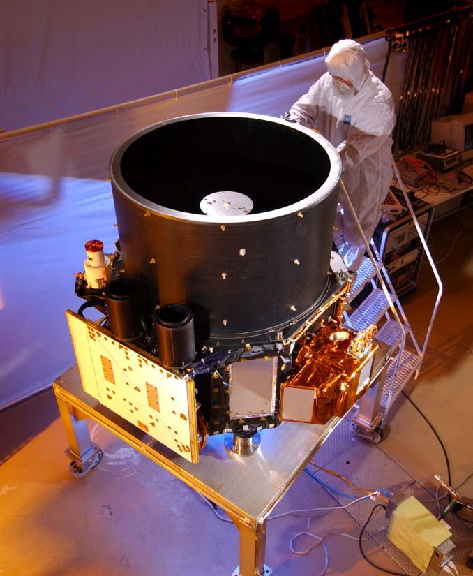
3 CALIPSO Payload CALIOP Wide Field Camera (WFC) Imaging Infrared Radiometer (IIR) 3


4 CALIPSO aerosol products: - aerosol layer heights - backscatter and extinction at 532 nm and 1064 nm - depolarization at 532 nm - color ratio (β 1064 /β 532 ) - aerosol type Cirrus LITE, September 1994 Dust Low clouds


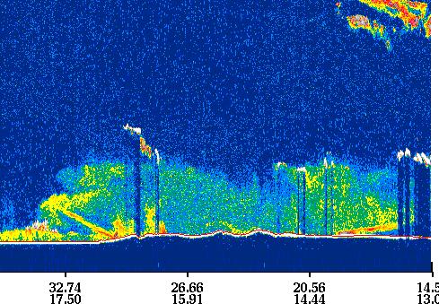


5 CALIOP Level 1 profiles + Cloud/Aerosol Mask 532 nm backscatter 532-cross-polarized 1064 nm Clouds (blue), aerosols (orange)
6 Lidar strengths and weaknesses Good Vertically resolved (30 m) Small footprint (70 m), good cloud clearing Not restricted by lighting conditions and surface type aerosol day and night over all surfaces (snow,...) Observes aerosol and cloud in the same column Depolarization: great for Identifying dust Separating tenuous ice cloud from non-dust aerosol Bad Nadir only Limitations due to SNR 180-backscatter has limited information aerosol profiles over eastern US
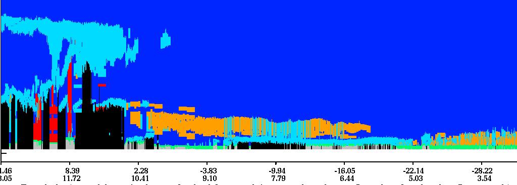
7 CALIOP Data Products Level 1 (geolocated and calibrated) DP profiles of attenuated lidar backscatter (532, 532, 1064 nm) Level 2 DP 2.1A Cloud/Aerosol layer product layer base and top heights, layer-optical depth, aerosol type, cloud I/W phase DP 2.1B Aerosol profile product Profiles of backscatter, extinction, depolarization, DP 2.1C Cloud profile product Profiles of backscatter, extinction, depolarization, ice/water content DP 2.1D Vertical Feature mask cloud/aerosol locations, aerosol type, cloud phase Level 3 (in development) Gridded aerosol and cloud statistics (available at
8 Extinction Uncertainty Estimate Uncertainty in Particulate Backscatter Coefficients at Altitude n 2 ( ) ( X ) 1 σ ( βm,n ) ( S ) ( ) ( T ) 2 2 ( p,n 1 ) ( ) σ βp,n 2 σ n 2 σ σ η σ p,n 1 σ β 2 p,n 1 = A 2 n ( 2 p,n) + ητ Bn 2 βp,n Xn Rn βm,n S η T βp,n 1 Measurement Uncertainty Molecular Number Density Uncertainty Lidar Ratio Uncertainty Accumulated Aerosol Attenuation Uncertainty Multiple Scattering Uncertainty Includes errors due to Calibration SNR molecular density (again) offset calculations polarization gain ratio polarization cross-talk ranging LEGEND S = lidar ratio β = backscatter coefficient R = scattering ratio σ 2 (x) = variance of x T = transmittance τ = optical depth m = molecular p = particulate (e.g., aerosol) P = measured data C = calibration constant η = multiple scattering factor ( n) ( ) 2 rn P r Rn 1 Xn= X( rn) = 2 n = CT m rn Rn 1 1 Rn m,n S r β η Δn = S η Δr β A n n p,n 1 B


")


9 CALIOP measures clouds too! ISCCP-IR CALIOP High Cloud (> 440 mb) Low Cloud (< 680 mb) ice cloud water cloud
 ocean Coakley and Tahnk:")

10 Aerosol Optical Depth: MODIS vs. CALIOP CALIOP AOD vs. MODIS (matched, instantaneous footprints) ocean Coakley and Tahnk: In large, cloud-free ocean regions (to avoid near-cloud effects) find CALIOP 532 nm AOD agrees well with MODIS 550 nm AOD (CALIPSO biased low) land

11 Aerosol type AOD - Dust AOD - Smoke Identify 6 aerosol types: Pollution 70 sr Smoke 70 sr Dust 40 sr Polluted dust 65 sr Clean marine 20 sr Clean continental35 sr OMI - AI smoke dust
 Preliminary comparisons show")

12 CALIPSO aerosol type vs. GOCART (Mian Chin) Preliminary comparisons show model and CALIOP agree on aerosol types and vertical distribution most of the time in cases studied Dust Pollution Seasalt


 CALIOP extinction")
13 Regional profile comparisons vs GOCART CALIOP instantaneous sensitivity ~ 0.01 /km HSRL CALIOP Hongbin Yu, et al. (JGR, 2010) CALIOP extinction GOCART extinction dust non-dust DJF MAM DJF MAM

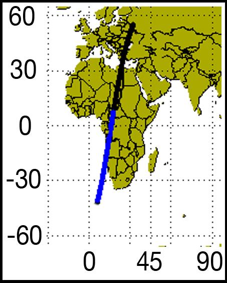
14 Aerosol Transport Studies include model verification, skill assessment data assimilation and fusion forecasts in support of field campaigns Saharan Dust Outbreak Aug 2006
, HYSPLIT dust trajectory (white-black")

15 Long Range Transport: Asian dust (Uno et al, 2009) CALIPSO orbit paths (red lines), HYSPLIT dust trajectory (white-black thick line) and SPRINTARS simulated dust extinction (tone) along HYSPLIT trajectory CALIOP depol + SPRINTARS dust extinction (contours)

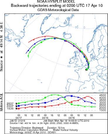
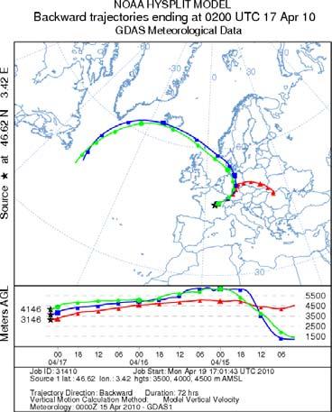
16 Volcanic plumes: Eyjafjallajökull - 17 April

 vs.")
17 CALIOP and Volcanoes Nadir only Sparse coverage, significant features can be missed Data latency limitations: driven by payload and ground system Latency of standard products ~3-5 days Expedited product latency ~12 hours from ground reception Sensitive to ~ 0.01 /km (roughly 10 μg/m 3 ) vs. engine damage threshold? Identification can be ambiguous volcanic sulfate aerosol + ash (possibly mixed with condensed water) vs. normal cloud more difficult to identify plume as it descends lower in the atmosphere 1-day coverage 16-day coverage


18 Multi-sensor observations of Eyjafjallajökull plume CALIPSO aerosol/cloud CloudSat clouds MODIS RGB OMI SO 2
19 Summary CALIPSO launched on April 28, 2006 Data is used widely, validation is continuing >200 Publications published or submitted using CALIPSO data New version of data to be released in May 2010 Likely mission life: thru Spacecraft and payload currently healthy Mission currently funded through 2011 Fuel to remain in A-train till 2016 Continuity of aerosol profiling: ADM (ESA) 2013 (?) EarthCare (ESA/JAXA) 2014 ACE (NASA) 2019 (??)
Developments in CALIOP Aerosol Products. Dave Winker
 Developments in CALIOP Aerosol Products Dave Winker NASA Langley Research Center Hampton, VA Winker - 1 Outline Level 3 aerosol product (beta-version) Version 4 Level 1 product A few CALIOP assimilation
CALIPSO Data Products: progress and status
 ICAP 13 July 2016 CALIPSO Data Products: progress and status Dave Winker, Jason Tackett NASA Langley Research Center With help from: Mark Vaughan, Stuart Young, Jay Kar, Ali Omar, Zhaoyan Liu, Brian Getzewich,
CATS GSFC TEAM Matt McGill, John Yorks, Stan Scott, Stephen Palm, Dennis Hlavka, William Hart, Ed Nowottnick, Patrick Selmer, Andrew Kupchock
 The Cloud-Aerosol Transport System (CATS) CATS GSFC TEAM Matt McGill, John Yorks, Stan Scott, Stephen Palm, Dennis Hlavka, William Hart, Ed Nowottnick, Patrick Selmer, Andrew Kupchock CATS LaRC Team Chip
AEROSOL LIDAR ACTIVITIES AT ECMWF: STATUS AND PLANS
 AEROSOL LIDAR ACTIVITIES AT ECMWF: STATUS AND PLANS Angela Benedetti & Julie Letrerte-Danczak ECMWF In collaboration with: Marijana Crepulja, Martin Suttie, Mohamed Daouhi and Luke Jones Scientific motivation
CALIPSO measurements of clouds, aerosols, ocean surface mean square slopes, and phytoplankton backscatter
 CALIPSO measurements of clouds, aerosols, ocean surface mean square slopes, and phytoplankton backscatter Yongxiang Hu, Chris Hostetler, Kuanman Xu,, and CALIPSO team NASA Langley Research Center Alain
CALIPSO Lessons Learned: Retrieval aspects, CAL/VAL, and Scientific Applications
 CALIPSO Lessons Learned: Retrieval aspects, CAL/VAL, and Scientific Applications Aeolus Workshop, Frascati, 10-13 Feb 2015 First light: 7 June 2006 Three co-aligned instruments: CALIOP: polarization lidar
Overview of The CALIPSO Mission
 Overview of The CALIPSO Mission Dave Winker NASA-LaRC LaRC,, PI Jacques Pelon IPSL/CNRS, co-pi Research Themes Improved understanding of the Earth s climate system is a primary goal of the Scientific Community
Ground-based Validation of spaceborne lidar measurements
 Ground-based Validation of spaceborne lidar measurements Ground-based Validation of spaceborne lidar measurements to make something officially acceptable or approved, to prove that something is correct
Long-term aerosol and cloud database from correlative CALIPSO and EARLINET observations
 Long-term aerosol and cloud database from correlative CALIPSO and EARLINET observations Ulla Wandinger, Anja Hiebsch, Ina Mattis Leibniz Institute for Tropospheric Research, Leipzig, Germany Gelsomina
Projects in the Remote Sensing of Aerosols with focus on Air Quality
 Projects in the Remote Sensing of Aerosols with focus on Air Quality Faculty Leads Barry Gross (Satellite Remote Sensing), Fred Moshary (Lidar) Direct Supervision Post-Doc Yonghua Wu (Lidar) PhD Student
Using Airborne High Spectral Resolution Lidar Data to Evaluate Combined Active/Passive Retrievals of Aerosol Extinction Profiles
 Using Airborne High Spectral Resolution Lidar Data to Evaluate Combined Active/Passive Retrievals of Aerosol Extinction Profiles Richard Ferrare, Sharon Burton, Chris Hostetler, John Hair, Anthony Cook,
Data Assimilation of Satellite Lidar Aerosol Observations
 Data Assimilation of Satellite Lidar Aerosol Observations Thomas Sekiyama Meteorological Research Institute Japan Meteorological Agency (MRI/JMA) AICS Data Assimilation Workshop, 27 February 2013, Kobe,
An Observational Study of the Relationship between Cloud, Aerosol and Meteorology in Marine Stratus Regions
 An Observational Study of the Relationship between Cloud, Aerosol and Meteorology in Marine Stratus Regions Norman G. Loeb NASA Langley Research Center Hampton, VA Oct 18 th, 2006, AeroCom Meeting (Virginia
CATS-ISS (Cloud-Aerosol Transport System for ISS) Science Overview
 Science Overview") CATS-ISS (Cloud-Aerosol Transport System for ISS) Science Overview Directed Opportunity Payload Delivery Date: April 2013 Planned Launch Readiness Date: mid-2013 CATS is a directed opportunity funded directly
CATS-ISS (Cloud-Aerosol Transport System for ISS) Science Overview Directed Opportunity Payload Delivery Date: April 2013 Planned Launch Readiness Date: mid-2013 CATS is a directed opportunity funded directly
Vertical distribution of dust aerosols from 5 years of CALIPSO observations
 Vertical distribution of dust aerosols from 5 years of CALIPSO observations, Alain Chédin, Sophie Peyridieu Laboratoire de Météorologie Dynamique CNRS/IPSL, Ecole Polytechnique christoforos.tsamalis@lmd.polytechnique.fr
Improving the CALIPSO VFM product with Aqua MODIS measurements
 University of Nebraska - Lincoln DigitalCommons@University of Nebraska - Lincoln NASA Publications National Aeronautics and Space Administration 2010 Improving the CALIPSO VFM product with Aqua MODIS measurements
Incorporating Volcanic Eruptions into Near Real time Aerosol Forecasts
 Incorporating Volcanic Eruptions into Near Real time Aerosol Forecasts Eric Hughes 1 Nick Krotkov 2 Arlindo Da Silva 2 Peter Colarco 2 (1) University of MD Department of Atmospheric and Oceanic Sciences
History of Aerosol Remote Sensing. Mark Smithgall Maria Zatko 597K Spring 2009
 History of Aerosol Remote Sensing Mark Smithgall Maria Zatko 597K Spring 2009 Aerosol Sources Anthropogenic Biological decomposition from fertilizer and sewage treatment (ex. ammonium) Combustion of fossil
Title: The Impact of Convection on the Transport and Redistribution of Dust Aerosols
 Authors: Kathryn Sauter, Tristan L'Ecuyer Title: The Impact of Convection on the Transport and Redistribution of Dust Aerosols Type of Presentation: Oral Short Abstract: The distribution of mineral dust
Systematic coordinated Saharan dust profiling over Europe in the frame of the EARLINET project ( )
") 10 th Anniversary Systematic coordinated Saharan dust profiling over Europe in the frame of the EARLINET project (2000-2010) 2010) Alex PAPAYANNIS (Coordinator) and the EARLINET Team Outline Role of aerosols
10 th Anniversary Systematic coordinated Saharan dust profiling over Europe in the frame of the EARLINET project (2000-2010) 2010) Alex PAPAYANNIS (Coordinator) and the EARLINET Team Outline Role of aerosols
Lecture 14. Principles of active remote sensing: Lidars. Lidar sensing of gases, aerosols, and clouds.
 Lecture 14. Principles of active remote sensing: Lidars. Lidar sensing of gases, aerosols, and clouds. 1. Optical interactions of relevance to lasers. 2. General principles of lidars. 3. Lidar equation.
Steve Ackerman, R. Holz, R Frey, S. Platnick, A. Heidinger, and a bunch of others.
 Steve Ackerman, R. Holz, R Frey, S. Platnick, A. Heidinger, and a bunch of others. Outline Using CALIOP to Validate MODIS Cloud Detection, Cloud Height Assignment, Optical Properties Clouds and Surface
CALIPSO On-Orbit - Lidar
 CALIPSO On-Orbit - Lidar Cloud - Aerosol Lidar and Infrared Pathfinder Satellite Observations Lidar Data Curtain Carl Weimer 3/21/07 Outline Why CALIPSO? Some Early Science Results Selected Engineering
PHEOS - Weather, Climate, Air Quality
 Aerosol & cloud remote sensing over the Arctic : perspectives for the PHEMOS and meteorological imager payloads on the PCW mission Norm O Neill, Auromeet Saha, U. de Sherbrooke Chris E. Sioris, Jack McConnell,
On the Satellite Determination of Multilayered Multiphase Cloud Properties. Science Systems and Applications, Inc., Hampton, Virginia 2
 JP1.10 On the Satellite Determination of Multilayered Multiphase Cloud Properties Fu-Lung Chang 1 *, Patrick Minnis 2, Sunny Sun-Mack 1, Louis Nguyen 1, Yan Chen 2 1 Science Systems and Applications, Inc.,
Satellite observation of atmospheric dust
 Satellite observation of atmospheric dust Taichu Y. Tanaka Meteorological Research Institute, Japan Meteorological Agency 11 April 2017, SDS WAS: Dust observation and modeling @WMO, Geneva Dust observations
Aerosol type how to use the information from satellites for models???
 Aerosol type how to use the information from satellites for models??? Mian Chin, NASA Goddard Space Flight Center AeroCom/AeroSat workshop, September 2016 What does type mean? Satellite Estimated based
CALIPSO: Global aerosol and cloud observations from lidar and passive instruments
 CALIPSO: Global aerosol and cloud observations from lidar and passive instruments L. R. Poole* a, D. M. Winker** a, J. R. Pelon #b, M. P. McCormick ##c a NASA Langley Research Center; b Universite Pierre
Satellite Constraints on Arctic-region Airborne Particles Ralph Kahn NASA Goddard Space Flight Center
 Satellite Constraints on Arctic-region Airborne Particles Ralph Kahn NASA Goddard Space Flight Center Sea of Okhotsk, MODIS image Feb. 6, 2007, NASA Earth Observatory Arctic Aerosol Remote Sensing Overview
Airborne High Spectral Resolution Lidar Aerosol Measurements and Comparisons with GEOS-5 Model
 Airborne High Spectral Resolution Lidar Aerosol Measurements and Comparisons with GEOS-5 Model Richard Ferrare, Chris Hostetler, John Hair, Anthony Cook, David Harper, Mike Obland, Ray Rogers, Sharon Burton,
Spaceborne Aerosol and Ozone Lidars for Air Quality Applications
 Spaceborne Aerosol and Ozone Lidars for Air Quality Applications Rich Ferrare Chris Hostetler Ed Browell John Hair NASA Langley Research Center Detlef Müller Institute for Tropospheric Research, Leipzig
Satellite Observations of the Impacts of Fine Particle Pollution on Climate Change. Lorraine Remer NASA/Goddard Space Flight Center
 Satellite Observations of the Impacts of Fine Particle Pollution on Climate Change Lorraine Remer NASA/Goddard Space Flight Center Hemispheric Transport of Air Pollution, Paris June 17-19, 2009 Take home
Sources and Properties of Atmospheric Aerosol in Texas: DISCOVER-AQ Measurements and Validation
 Sources and Properties of Atmospheric Aerosol in Texas: DISCOVER-AQ Measurements and Validation Thanks to: Rebecca Sheesley and Sascha Usenko, Baylor Barry Lefer, U. Houston, AQRP Sarah D. Brooks T. Ren,
A Novel Cirrus Cloud Retrieval Method For GCM High Cloud Validations
 A Novel Cirrus Cloud Retrieval Method For GCM High Cloud Validations David Mitchell Anne Garnier Melody Avery Desert Research Institute Science Systems & Applications, Inc. NASA Langley Reno, Nevada Hampton,
Lecture 4b: Meteorological Satellites and Instruments. Acknowledgement: Dr. S. Kidder at Colorado State Univ.
 Lecture 4b: Meteorological Satellites and Instruments Acknowledgement: Dr. S. Kidder at Colorado State Univ. US Geostationary satellites - GOES (Geostationary Operational Environmental Satellites) US
A new perspective on aerosol direct radiative effects in South Atlantic and Southern Africa
 A new perspective on aerosol direct radiative effects in South Atlantic and Southern Africa Ian Chang and Sundar A. Christopher Department of Atmospheric Science University of Alabama in Huntsville, U.S.A.
The EarthCARE mission: An active view on aerosols, clouds and radiation
 The EarthCARE mission: An active view on aerosols, clouds and radiation T. Wehr, P. Ingmann, T. Fehr Heraklion, Crete, Greece 08/06/2015 EarthCARE is ESA s sixths Earth Explorer Mission and will be implemented
What are Aerosols? Suspension of very small solid particles or liquid droplets Radii typically in the range of 10nm to
 What are Aerosols? Suspension of very small solid particles or liquid droplets Radii typically in the range of 10nm to 10µm Concentrations decrease exponentially with height N(z) = N(0)exp(-z/H) Long-lived
The CEOS Atmospheric Composition Constellation (ACC) An Example of an Integrated Earth Observing System for GEOSS
 An Example of an Integrated Earth Observing System for GEOSS") The CEOS Atmospheric Composition Constellation (ACC) An Example of an Integrated Earth Observing System for GEOSS Presentation Authors: E. Hilsenrath NASA, C. Zehner ESA, J. Langen ESA, J. Fishman NASA
The CEOS Atmospheric Composition Constellation (ACC) An Example of an Integrated Earth Observing System for GEOSS Presentation Authors: E. Hilsenrath NASA, C. Zehner ESA, J. Langen ESA, J. Fishman NASA
Backscatter Color Ratios of Cirrus Clouds Measured by the Cloud Physics Lidar
 Backscatter Color Ratios of Cirrus Clouds Measured by the Cloud Physics Lidar M. A. Vaughan 1, M. J. McGill, Z. Liu 3, Y. Hu 1, and R. E. Kuehn 4, and S. D. Rodier 4 NASA Langley Research Center, Hampton
Launched on May 4, K. Hokusai
 CITES-2009 CITES-2009 CONFERENCE CONFERENCE KRASNOYARSK, KRASNOYARSK, Russia Russia OBSERVING THE EARTH FROM SPACE AS AN INTEGRATED SYSTEM: THE USA/F* A-TRAIN CONCEPT G. BEGNI, D. RENAUT (CNES CNES), D.
Influence of Clouds and Aerosols on the Earth s Radiation Budget Using Clouds and the Earth s Radiant Energy System (CERES) Measurements
 Measurements") Influence of Clouds and Aerosols on the Earth s Radiation Budget Using Clouds and the Earth s Radiant Energy System (CERES) Measurements Norman G. Loeb Hampton University/NASA Langley Research Center Bruce
Influence of Clouds and Aerosols on the Earth s Radiation Budget Using Clouds and the Earth s Radiant Energy System (CERES) Measurements Norman G. Loeb Hampton University/NASA Langley Research Center Bruce
Seasonal Aerosol Vertical Distribution and Optical Properties over North China Xing-xing GAO, Yan CHEN, Lei ZHANG * and Wu ZHANG
 2017 International Conference on Energy, Environment and Sustainable Development (EESD 2017) ISBN: 978-1-60595-452-3 Seasonal Aerosol Vertical Distribution and Optical Properties over North China Xing-xing
The Green-OAWL (GrOAWL) Airborne Demonstrator for the ATHENA-OAWL Mission Concept: System Progress and Flight Plans
 Airborne Demonstrator for the ATHENA-OAWL Mission Concept: System Progress and Flight Plans") The Green-OAWL (GrOAWL) Airborne Demonstrator for the ATHENA-OAWL Mission Concept: System Progress and Flight Plans International Winds Working Group Workshop 27 June 1 July 2016 Monterey, CA Sara Tucker
The Green-OAWL (GrOAWL) Airborne Demonstrator for the ATHENA-OAWL Mission Concept: System Progress and Flight Plans International Winds Working Group Workshop 27 June 1 July 2016 Monterey, CA Sara Tucker
Aerosol and cloud related products by ESA s Aeolus mission
 Aerosol and cloud related products by ESA s Aeolus mission Stefano Casadio 1, Anne Grete Straume 2, Christophe Caspar 2 1 IDEAS/SERCO, 2 ESA Anne.Straume@esa.int, Stefano.Casadio@esa.int, Christope.Caspar@esa.int
Aerosol Impact on the GEOS-5 Meteorological Analysis
 Aerosol Impact on the GEOS-5 Meteorological Analysis Arlindo da Silva Global Modeling and Assimilation Office NASA Goddard Space Flight Center arlindo.dasilva@nasa.gov With contributions from: Jong Kim,
Aerosols and Clouds: Long-term Database from Spaceborne Lidar Measurements
 AEROSOLS AND CLOUDS: LONG-TERM DATABASE FROM SPACEBORNE LIDAR MEASUREMENTS ESTEC Contract No. 21487/08/NL/HE Aerosols and Clouds: Long-term Database from Spaceborne Lidar Measurements Executive Summary
The EarthCARE mission: An active view on aerosols, clouds and radiation
 The EarthCARE mission: An active view on aerosols, clouds and radiation T. Wehr, T. Fehr, P. Ingmann, J. v. Bismarck ESRIN, Frascati, Italy 20/10/2015 EARTH Clouds, Aerosols and Radiation Explorer EarthCARE
Atmospheric Lidar The Atmospheric Lidar (ATLID) is a high-spectral resolution lidar and will be the first of its type to be flown in space.
 is a high-spectral resolution lidar and will be the first of its type to be flown in space.") www.esa.int EarthCARE mission instruments ESA s EarthCARE satellite payload comprises four instruments: the Atmospheric Lidar, the Cloud Profiling Radar, the Multi-Spectral Imager and the Broad-Band Radiometer.
www.esa.int EarthCARE mission instruments ESA s EarthCARE satellite payload comprises four instruments: the Atmospheric Lidar, the Cloud Profiling Radar, the Multi-Spectral Imager and the Broad-Band Radiometer.
IAA. 1.9: Aerosol-UA - Satellite remote sensing of aerosols in the Earth atmosphere
 IAA. 1.9: Aerosol-UA - Satellite remote sensing of aerosols in the Earth atmosphere Ya. Yatskiv (1), O. Degtyaryov (3), G. Milinevsky (1,2), I. Syniavskyi (1), A. Bovchaliuk (1), Yu. Ivanov (1), M. Sosonkin
Aerosol Retrieved from MODIS: Algorithm, Products, Validation and the Future
 Aerosol Retrieved from MODIS: Algorithm, Products, Validation and the Future Presented by: Rob Levy Re-presenting NASA-GSFC s MODIS aerosol team: Y. Kaufman, L. Remer, A. Chu,, C. Ichoku,, R. Kleidman,,
CHARACTERIZATION OF PROPERTIES AND SPATIOTEMPORAL FIELDS OF MINERAL AEROSOL AND ITS RADIATIVE IMPACT USING CALIPSO DATA IN CONJUNCTION
 CHARACTERIZATION OF PROPERTIES AND SPATIOTEMPORAL FIELDS OF MINERAL AEROSOL AND ITS RADIATIVE IMPACT USING CALIPSO DATA IN CONJUNCTION WITH A-TRAIN SATELLITE AND GROUND-BASED OBSERVATIONS AND MODELING
Observation of Smoke and Dust Plume Transport and Impact on the Air Quality Remote Sensing in New York City
 Observation of Smoke and Dust Plume Transport and Impact on the Air Quality Remote Sensing in New York City Yonghua Wu*, Chowdhury Nazmi, Cuiya Li, Daniel Hoyos, Barry Gross, Fred Moshary NOAA-CREST and
CALIPSO lidar level 3 aerosol profile product: version 3 algorithm design
 CALIPSO lidar level 3 aerosol profile product: version 3 algorithm design Jason L. Tackett 1,2, David M. Winker 2, Brian J. Getzewich 1,2, Mark A. Vaughan 2, Stuart A. Young 1, and Jayanta Kar 1,2 1 Science
ACTRIS aerosol vertical profiles: advanced data and their potential use in a aerosol observations/models combined approach
 ACTRIS aerosol vertical profiles: advanced data and their potential use in a aerosol observations/models combined approach Lucia Mona CNR-IMAA, Potenza, Italy mona@imaa.cnr.it and EARLINET Team OUTLINE
ADM-Aeolus ESA s Wind Lidar Mission and its spin-off aerosol profile products
 ADM-Aeolus ESA s Wind Lidar Mission and its spin-off aerosol profile products A. Dehn, A.G. Straume, A. Elfving, F. de Bruin, T. Kanitz, D. Wernham, D. Schuettemeyer, F. Buscaglione, W. Lengert European
Validation of ECMWF global forecast model parameters using GLAS atmospheric channel measurements
 GEOPHYSICAL RESEARCH LETTERS, VOL. 32, L22S09, doi:10.1029/2005gl023535, 2005 Validation of ECMWF global forecast model parameters using GLAS atmospheric channel measurements Stephen P. Palm, 1 Angela
Natural and anthropogenic aerosols in the UTLS: Sources and role of Asian monsoon transport
 Natural and anthropogenic aerosols in the UTLS: Sources and role of Asian monsoon transport Mian Chin, NASA Goddard Space Flight Center + Tom Kucsera, Thomas Diehl, Huisheng Bian, Valentina Aquila, Qian
The definition of an atmospheric database for Aeolus
 Atmos. Meas. Tech., 4, 67 88, 211 www.atmos-meas-tech.net/4/67/211/ doi:1.194/amt-4-67-211 Author(s) 211. CC Attribution 3. License. Atmospheric Measurement Techniques The definition of an atmospheric
APPLICATION OF CCNY LIDAR AND CEILOMETERS TO THE STUDY OF AEROSOL TRANSPORT AND PM2.5 MONITORING
 P1.14 APPLICATION OF CCNY LIDAR AND CEILOMETERS TO THE STUDY OF AEROSOL TRANSPORT AND PM2.5 MONITORING Leona A. Charles*, Shuki Chaw, Viviana Vladutescu, Yonghua Wu, Fred Moshary, Barry Gross, Stanley
Monitoring trace gas emissions and transport with Aura and the A-Train
 Monitoring trace gas emissions and transport with Aura and the A-Train Simon Carn Dept. of Geological and Mining Engineering, Michigan Technological University, Houghton, MI Aura (2004-) OMI - SO 2, NO
Final Report: NASA Award Number, NNX07AR95G, entitled, COMPARISON OF A - TRAIN CLOUD RETRIEVALS AND MULTI-INSTRUMENT ALGORITHM STUDIES.
 Final Report: NASA Award Number, NNX07AR95G, entitled, COMPARISON OF A - TRAIN CLOUD RETRIEVALS AND MULTI-INSTRUMENT ALGORITHM STUDIES. For the period of August 15, 2007 August 14, 2010 Principal Investigator:
Long-Term Time Series of Water Vapour Total Columns from GOME, SCIAMACHY and GOME-2
 Graphics: ESA Graphics: ESA Graphics: ESA Long-Term Time Series of Water Vapour Total Columns from GOME, SCIAMACHY and GOME-2 S. Noël, S. Mieruch, H. Bovensmann, J. P. Burrows Institute of Environmental
The Orbiting Carbon Observatory (OCO)
") GEMS 2006 Assembly The Orbiting Carbon Observatory (OCO) http://oco.jpl.nasa.gov David Crisp, OCO PI (JPL/Caltech) February 2006 1 of 13, OCO Dec 2005 Page 1 The Orbiting Carbon Observatory (OCO) OCO will
GEMS 2006 Assembly The Orbiting Carbon Observatory (OCO) http://oco.jpl.nasa.gov David Crisp, OCO PI (JPL/Caltech) February 2006 1 of 13, OCO Dec 2005 Page 1 The Orbiting Carbon Observatory (OCO) OCO will
Cloud Occurrence from the level 2B CloudSat- CALIPSO Cloud Mask Data
 Cloud Occurrence from the level 2B CloudSat- CALIPSO Cloud Mask Data Jay Mace and Qiuqing Zhang 1. Briefly introduce Geoprof-Lidar Product 2. Examine the vertical and horizontal distribution of cloud occurrence
Report Benefits and Challenges of Geostationary Ocean Colour Remote Sensing - Science and Applications. Antonio Mannino & Maria Tzortziou
 Report Benefits and Challenges of Geostationary Ocean Colour Remote Sensing - Science and Applications Antonio Mannino & Maria Tzortziou Time & Space Scales of OC Relevant Missions GOCI I & II Geo from
10 years of stratospheric aerosol observadons from CALIPSO J.-P. Vernier, L.W. Thomason, T.D. Fairlie, J. Kar, M. Natarajan
 10 years of stratospheric aerosol observadons from CALIPSO J.-P. Vernier, L.W. Thomason, T.D. Fairlie, J. Kar, M. Natarajan CALIPSO-Cloudsat 10th Anni versary workshop, June 2016, Paris Some important
NASA's Plankton, Aerosol, Cloud, ocean Ecosystem (PACE) mission update
 mission update") NASA's Plankton, Aerosol, Cloud, ocean Ecosystem (PACE) mission update Antonio Mannino1, Jeremy Werdell1, Brian Cairns2 NASA GSFC1 and GISS2 Acknowledgments: PACE Team https://pace.gsfc.nasa.gov 1 Outline
NASA's Plankton, Aerosol, Cloud, ocean Ecosystem (PACE) mission update Antonio Mannino1, Jeremy Werdell1, Brian Cairns2 NASA GSFC1 and GISS2 Acknowledgments: PACE Team https://pace.gsfc.nasa.gov 1 Outline
CALIPSO Data Visualization, Summer Term NASA DEVELOP National Program Technical Report, FY 2008
 CALIPSO Data Visualization, Summer Term NASA DEVELOP National Program Technical Report, FY 2008 The Evaluation and Application of CALIPSO Products with Focus on Expedited Data Retrievals, Temperature Dataset
Relationships among properties of marine stratocumulus derived from collocated CALIPSO and MODIS observations
 Click Here for Full Article JOURNAL OF GEOPHYSICAL RESEARCH, VOL. 115,, doi:10.1029/2009jd012046, 2010 Relationships among properties of marine stratocumulus derived from collocated CALIPSO and MODIS observations
Orbit and Transmit Characteristics of the CloudSat Cloud Profiling Radar (CPR) JPL Document No. D-29695
 JPL Document No. D-29695") Orbit and Transmit Characteristics of the CloudSat Cloud Profiling Radar (CPR) JPL Document No. D-29695 Jet Propulsion Laboratory California Institute of Technology Pasadena, CA 91109 26 July 2004 Revised
Orbit and Transmit Characteristics of the CloudSat Cloud Profiling Radar (CPR) JPL Document No. D-29695 Jet Propulsion Laboratory California Institute of Technology Pasadena, CA 91109 26 July 2004 Revised
The energy that drives Earth s climate system
 The CALIPSO Mission A Global 3D View of Aerosols and Clouds by D. M. Wi n k e r, J. Pe l o n, J. A. Co a k l e y Jr., S. A. Ac k e r m a n, R. J. Ch a r l s o n, P. R. Co l a r c o, P. Fl a m a n t, Q.
Spaceborne Wind Lidar Observations by Aeolus Data Products and Pre-Launch Validation with an Airborne Instrument
 DRAGON 3 Project ID 10532 Cal/Val Spaceborne Wind Lidar Observations by Aeolus Data Products and Pre-Launch Validation with an Airborne Instrument Reitebuch Oliver, Lemmerz Christian, Marksteiner Uwe,
Atmopsheric Observance Satellites and Cloud Aerosol Effects. Kiran Sathaye ABSTRACT
 Atmopsheric Observance Satellites and Cloud Aerosol Effects Kiran Sathaye ABSTRACT Atmospheric dynamics and indirect effects represent a large portion of the uncertainty in the understanding of Earth s
The combined use of MODIS, CALIPSO and OMI level 2 aerosol products for calculating direct aerosol radiative effects
 The combined use of MODIS, CALIPSO and OMI level 2 aerosol products for calculating direct aerosol radiative effects Jens Redemann, M. Vaughan, Y. Shinozuka, Q. Zhang, P. Russell, J. Livingston, L. Remer
Climate change. understanding, and the need for observations Herman Russchenberg Remote Sensing of the Environment.
 Climate change understanding, and the need for observations Herman Russchenberg Remote Sensing of the Environment 19-11-2011 h.w.j.russchenberg@tudelft.nl Delft University of Technology Challenge the future
Global Cloud Climatologies from satellite-based InfraRed Sounders (TOVS, AIRS, IASI) +
 +") Global Cloud Climatologies from satellite-based InfraRed Sounders (TOVS, AIRS, IASI) + AIRS-CALIPSO-CloudSat Synergy Claudia Stubenrauch * until 2010 S. Cros*, A. Guignard, N. Lamquin*, R. Armante, A.
Global Cloud Climatologies from satellite-based InfraRed Sounders (TOVS, AIRS, IASI) + AIRS-CALIPSO-CloudSat Synergy Claudia Stubenrauch * until 2010 S. Cros*, A. Guignard, N. Lamquin*, R. Armante, A.
ADM-Aeolus Progressing Towards Mission Exploitation
 ADM-Aeolus Progressing Towards Mission Exploitation Paul Ingmann and Anne Grete Straume Mission Science Division, ESA/ESTEC, Noordwijk, NL Herbert Nett ADM-Aeolus Project, ESA/ESTEC, Noordwijk, NL Oliver
Carl Weimer. December 1, 2014
 The CALIPSO Spaceborne Lidar Carl Weimer cweimer@ball.com December 1, 2014 Some Lidars/Altimeters in Space Apollo 15 1971 Ranging (Moon) Clementine 1994 Ranging (Moon) LITE 1994 Profiling Aerosols and
Atmospheric Basics AOSC 200 Tim Canty
 Atmospheric Basics AOSC 200 Tim Canty Class Web Site: http://www.atmos.umd.edu/~tcanty/aosc200 Topics for today: Structure of the Atmosphere Temperature vs height Atmospheric pressure Atmospheric composition
ESA Climate Change Initiative (CCI)
") ESA Climate Change Initiative (CCI) New ESA Programme with the aim to contribute to worldwide efforts to generate Essential Climate Variables (ECVs) C. Zehner Barcelona, 07/09/2009 Two climate action paths
ESA Climate Change Initiative (CCI) New ESA Programme with the aim to contribute to worldwide efforts to generate Essential Climate Variables (ECVs) C. Zehner Barcelona, 07/09/2009 Two climate action paths
Aerosol Impact on Infrared METOC Data Assimilation
 DISTRIBUTION STATEMENT A. Approved for public release; distribution is unlimited. Aerosol Impact on Infrared METOC Data Assimilation Douglas L. Westphal phone: (831) 656-4743 fax: (408) 656-4769 email:
An evaluation of CALIOP/CALIPSO s aerosolabove-cloud detection and retrieval capability over North America
 University of Nebraska - Lincoln DigitalCommons@University of Nebraska - Lincoln NASA Publications National Aeronautics and Space Administration 2014 An evaluation of CALIOP/CALIPSO s aerosolabove-cloud
Aerosol forecasting and assimilation at ECMWF: overview and data requirements
 Aerosol forecasting and assimilation at ECMWF: overview and data requirements Angela Benedetti Luke Jones ECMWF Acknowledgements: Jean-Jacques Morcrette, Carole Peubey, Olaf Stiller, and Richard Engelen
Status and performance of the CALIOP lidar
 Status and performance of the CALIOP lidar David M. Winker* a, William Hunt b, and Chris Hostetler a a NASA Langley Research Center, MS/435, Hampton, Virginia 23681, USA *b Wyle Laboratories, Hampton,
Saharan Dust Induced Radiation-Cloud-Precipitation-Dynamics Interactions
 Saharan Dust Induced Radiation-Cloud-Precipitation-Dynamics Interactions William K. M. Lau NASA/GSFC Co-authors: K. M. Kim, M. Chin, P. Colarco, A. DaSilva Atmospheric loading of Saharan dust Annual emission
Quantifying above-cloud aerosol using spaceborne lidar for improved understanding of cloudy-sky direct climate forcing
 Click Here for Full Article JOURNAL OF GEOPHYSICAL RESEARCH, VOL. 113,, doi:10.1029/2007jd009433, 2008 Quantifying above-cloud aerosol using spaceborne lidar for improved understanding of cloudy-sky direct
Intercomparison of column aerosol optical depths from CALIPSO and MODIS-Aqua
 Atmos. Meas. Tech., 4, 131 141, 2011 doi:10.5194/amt-4-131-2011 Author(s) 2011. CC Attribution 3.0 License. Atmospheric Measurement Techniques Intercomparison of column aerosol optical depths from CALIPSO
Multi-instrumental study of aerosol optical properties over the city of Sao Paulo: Lidar, sunphotometer and CALIPSO satellite
 Multi-instrumental study of aerosol optical properties over the city of Sao Paulo: Lidar, sunphotometer and CALIPSO satellite Fábio Juliano da Silva Lopes (*), Eduardo Landulfo Instituto de Pesquisas Energéticas
Sentinel-3 Sea and Land Surface Temperature Radiometer (SLSTR) Mireya Etxaluze (STFC RAL Space)
 Mireya Etxaluze (STFC RAL Space)") Sentinel-3 Sea and Land Surface Temperature Radiometer (SLSTR) Mireya Etxaluze (STFC RAL Space) RAL Space Radiometry Group Dave Smith Mireya Etxaluze, Ed Polehampton, Caroline Cox, Tim Nightingale, Dan
Sentinel-3 Sea and Land Surface Temperature Radiometer (SLSTR) Mireya Etxaluze (STFC RAL Space) RAL Space Radiometry Group Dave Smith Mireya Etxaluze, Ed Polehampton, Caroline Cox, Tim Nightingale, Dan
Aerosol measurements from Space. Gerrit de Leeuw FMI & Uni of Helsinki, Finland & TNO, Utrecht, Netherlands
 Aerosol measurements from Space Gerrit de Leeuw FMI & Uni of Helsinki, Finland & TNO, Utrecht, Netherlands ACCENT AT-2 Follow-up meeting Mainz, 22 June 2009 ACCENT AT-2 Outcomes The Remote Sensing of Tropospheric
3D structure of Asian dust transport revealed by CALIPSO lidar and a 4DVAR dust model
 GEOPHYSICAL RESEARCH LETTERS, VOL. 35, L06803, doi:10.1029/2007gl032329, 2008 3D structure of Asian dust transport revealed by CALIPSO lidar and a 4DVAR dust model I. Uno, 1 K. Yumimoto, 2 A. Shimizu,
Future NASA Atmospheric Missions: Adding to the A-Train Calipso OCO NPP CloudSat Glory
 Future NASA Atmospheric Missions: Adding to the A-Train James Gleason NASA Goddard Space Flight Center, Mail Code 613.3, Greenbelt, MD 20771, United States Abstract Following on the successful launch of
EARLINET Observations of Saharan Dust Outbreaks over Europe
 EARLINET Observations of Saharan Dust Outbreaks over Europe Ulla Wandinger Leibniz Institute for Tropospheric Research (TROPOS), Leipzig, Germany with contributions from the TROPOS Ground Based Remote
Using airborne high spectral resolution lidar data to evaluate combined active plus passive retrievals of aerosol extinction profiles
 Click Here for Full Article JOURNAL OF GEOPHYSICAL RESEARCH, VOL. 115,, doi:10.1029/2009jd012130, 2010 Using airborne high spectral resolution lidar data to evaluate combined active plus passive retrievals
Course outline, objectives, workload, projects, expectations
 Course outline, objectives, workload, projects, expectations Introductions Remote Sensing Overview Elements of a remote sensing observing system 1. platform (satellite, surface, etc) 2. experimental design
Measuring Carbon Dioxide from the A-Train: The OCO-2 Mission
 Measuring Carbon Dioxide from the A-Train: The OCO-2 Mission David Crisp, OCO-2 Science Team Leader for the OCO-2 Science Team Jet Propulsion Laboratory, California Institute of Technology March 2013 Copyright
Characterization of Atmospheric Mineral Dust from Radiometric and Polarimetric Remote Sensing
 Characterization of Atmospheric Mineral Dust from Radiometric and Polarimetric Remote Sensing PI: Dr. Irina N. Sokolik School of Earth and Atmospheric Sciences Georgia Institute of Technology 311 Ferst
Joint Polar Satellite System. 3 rd Post-EPS User Consultation Workshop Mike Haas
 3 rd Post-EPS User Consultation Workshop Mike Haas Overview Introduction - Policy Drivers - Management System Description - Space Segment - Ground Segment Partnerships Status Benefits 2 Introduction (Policy
Current capabilities and limitations of satellite monitoring and modeling forecasting of volcanic clouds: and example of Eyjafjallaj
 Current capabilities and limitations of satellite monitoring and modeling forecasting of volcanic clouds: and example of Eyjafjallaj fjallajökull eruption (pronounced EYE-a-fyat fyat-la-jo-kotl) N. Krotkov