ADM-Aeolus Progressing Towards Mission Exploitation
|
|
|
- Debra Davidson
- 6 years ago
- Views:
Transcription

1 ADM-Aeolus Progressing Towards Mission Exploitation Paul Ingmann and Anne Grete Straume Mission Science Division, ESA/ESTEC, Noordwijk, NL Herbert Nett ADM-Aeolus Project, ESA/ESTEC, Noordwijk, NL Oliver Reitebuch Institute of Atmospheric Physics, DLR, Oberpfaffenhofen, D paul.ingmann@esa.int
2 Overview Background The ADM-Aeolus Mission Cal/Val Announcement of Opportunity Campaigns and Pre-launch validation Other activities Conclusions
3 ADM-Aeolus objectives and requirements What are the scientific objectives? Improve understanding of Atmospheric dynamics and global atmospheric transport Global cycling of energy, water, aerosols, chemicals How are they achieved? Improved analysis of the atmospheric state to provide a more complete (three-dimensional) picture of the dynamical variables What are the benefits? Better initial conditions for weather forecasting Improved parameterisation of atmospheric processes in models Advanced climate and atmospheric flow modelling Will show ADM-Aeolus potential for full operational use
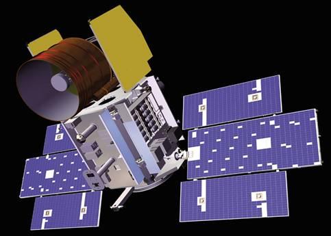
![Atmospheric Dynamics Mission ADM-Aeolus [H]LOS ADM-Aeolus with single payload Atmospheric LAser Doppler Instrument [ALADIN] Observations of Line-of-Sight LOS wind profiles in troposphere to lower](/docs-images/73/68404373/images/4-2.jpg "stratosphere up to 30 km with vertical resolution from 250 m - 2 km horizontally averaged over 50 km every 200 km High requirement on random error of HLOS <1 m/s (z=0-2 km, for Δz=0.")
4 Atmospheric Dynamics Mission ADM-Aeolus [H]LOS ADM-Aeolus with single payload Atmospheric LAser Doppler Instrument [ALADIN] Observations of Line-of-Sight LOS wind profiles in troposphere to lower stratosphere up to 30 km with vertical resolution from 250 m - 2 km horizontally averaged over 50 km every 200 km High requirement on random error of HLOS <1 m/s (z=0-2 km, for Δz=0.5 km) <2 m/s (z=2-16 km, for Δz= 1 km), unknown bias <0.4 m/s and linearity error <0.7 % of actual wind speed; HLOS: projection on horizontal of LOS => LOS accuracy = 0.6*HLOS 355 nm with spectrometers for molecular Rayleigh and aerosol/cloud Mie backscatter
 launch date late 2009 mission lifetime 39 months: observations from 2010-2012 Overview paper about")
5 ADM-Aeolus Coverage and Data Availability > 3000 wind profiles per day: about factor 3 more than radiosondes 3 hour data availability after observation (NRT-Service) => 1 datadownlink per orbit; 30 minutes data availability for parts of orbit (Quasi- NRT-Service with late start of downlink) launch date late 2009 mission lifetime 39 months: observations from Overview paper about ADM-Aeolus Stoffelen et al. 2005, Bull. Am. Met. Soc.
6 Ongoing ADM-Aeolus Scientific Activities Title Consolidation of ADM-Aeolus Ground Processing including L2A Products Development and Production of Aeolus Wind Data Products (Level 1B to L2B/C) Optimisation of spatial and temporal sampling A spontaneous Rayleigh-Brillouin Scattering Experiment ADM-Aeolus Campaigns Team DLR Germany & IPSL, Météo-France, KNMI ECMWF UK & Météo-France, KNMI KNMI, the Netherlands & Met.No, MISU University of Amsterdam, the Netherlands & Univ of Nijmegen, KNMI Tan et al Stoffelen et al DLR Germany & Météo-France, KNMI, IPSL, DWD, MIM
7 ADM-Aeolus AO Calls Considerations for CAL/VAL Validation requirements for co-location in time and space Limitations when comparing datasets with different measurement characteristics Inter-product dependencies, mission optimization, etc. ESA plans an Announcement of Opportunity AO for ADM-Aeolus scientific use of data for early 2009 in addition to the AO for Cal/Val
8 Critical validation points Validation of wind profiles and assimilated wind fields (L2B/C) and atmospheric optical properties products (L2A) Atmospheric heterogeneities co-location, slant versus vertical column, etc. Only the wind products can be directly evaluated by the ECMWF assimilation system Wind and aerosol products from space-based lidars or passive instruments, ground-base instrumentation, air-borne instrumentation, etc. instrument properties and error characteristics (Aeolus is a HSRL) Would like to draw from the Experience with validation of other satellite missions in-situ (e.g radiosonde) vs. layer averaged products (averaging kernels) measure at different wavelengths (approximate conversion laws from e.g. 2 μm and/or 522 nm to 355 nm if possible, measurements at 355 nm) varying surface albedo different viewing geometry, etc. The impact of atmospheric heterogeneities (e.g. clouds) on the Mie and Rayleigh wind product accuracies (the importance of scene classification and validation of the cross-talk corrections) Vertical sampling strategy w.r.t. Troposphere research Stratosphere research Regional effects
9 ADM-Aeolus Cal/Val AO Distribution of ADM-Aeolus Cal/Val Proposals Received Canada, 2 French consortium, 1 European, 1 US consortium, 1 P.R. China, 1 Germany, 5 Norway, 1 Netherlands, 2 Japan, 1
10 Cal/Val and Mission Phases Commissioning Phase (phase E1) First Three months of Mission: Specific campaigns designed to verify that data products are suitable for release to User Community Processing changes likely to evolve rapidly Access to data restricted to active participants (AO PIs) Routine operations (phase E2) rest of mission (3 years) Ongoing improvements to data products Emphasis on product stability. Slow changes only to the processing Novel scientific uses of data Access open to all proposals accepted as result of an up-coming Science AO
11 Cal/Val AO Time Table Updates required from PIs: 18 April 2008 Notification of the evaluation results to PIs: 25 April 2008 Start of ESA data delivery to accepted PIs: TBD (expected about 6 weeks after launch) Projects completion (Final reports): 2012 (TBC) AVRT (ADM-Aeolus Validation and Retrieval Team) Symposia or Workshops: First workshop early in 2009
12 Expected Outcome and Data Access The AO PIs are expected to play an active role in the validation of the data products Members of the AVRT will have access to ADM-Aeolus data products starting at Level 1b up to Level 2b During the commissioning phase of the satellite, data access will be limited to the AVRT members
13 ADM-Aeolus Science AO Release planned for 2009 Objectives Novel scientific use of the Aeolus data, e.g.: Foster research and application development in the field of atmospheric dynamics and climate research Impact of Aeolus wind and/or clouds and aerosols in NWP and climate research (including atmospheric transport and radiation budget) Contribute to long-term databases of wind and optical properties Support high-impact weather response through the improvement of forecasts ENSO? In the frame of GMES, exploit the synergy with other satellite based, ground-based, or air-borne measurement product

; flat terrain Campaign Team: 20 participants from DWD, University Munich, and DLR => www.pa.op.dlr.")
14 ADM-Aeolus Pre-Launch Campaigns First ground campaign in October 2006 Second ground campaign in July 2007 Objective Validate ALADIN instrument before launch with atmospheric signal and derive conclusions for retrieval algorithms and for on-ground and in-orbit test, verification and calibration of satellite instrument Specific topics are: radiometric and wind measurement performance, calibration procedures for Mie and Rayleigh spectrometers, quality-control, Rayleigh wind correction schemes (T, p), ground detection and zero-wind calibration Site: Meteorological Observatory of DWD in Lindenberg (southeast of Berlin, Northeast Germany); flat terrain Campaign Team: 20 participants from DWD, University Munich, and DLR =>
 355 nm DLR 2-µm Doppler Lidar (wind up")

 1290 MHz windprofiler (wind up to 1.")
 355 nm Raman-lidar RAMSES (profiles of water")
 35.")
 Ceilometer (clouds up to 12 km, aerosol backscatter in boundary layer)")
15 Instruments at DWD Lindenberg for Ground Campaigns Windprofiler site ALADIN Airborne Demonstrator A2D (LOS winds) 355 nm DLR 2-µm Doppler Lidar (wind up to 2-3 km); only Oct. 06 University Munich aerosol lidar MULIS (backscatter, extinction coefficient up to 10 km) 355 nm, 532 nm, Raman 482 MHz windprofiler with RASS (wind up to 16 km, temperature up to 4 km) 1290 MHz windprofiler (wind up to 1.5 km) ceilometer (clouds up to 12 km, aerosol backscatter in boundary layer) Optic laboratory (distance 500 m) 355 nm Raman-lidar RAMSES (profiles of water vapour mixing ratio and backscatter ratio during night) sun photometer (aerosol optical depth during day) 35.5 GHz cloud radar (reflectivity, vertical velocity, linear depolarisation ratio) Ceilometer (clouds up to 12 km, aerosol backscatter in boundary layer) Radiosondes (Vaisälä RS 92) 4 routine radiosondes per day (0, 6, 12, 18 UTC) and additional radiosondes on request (3, 9, 15, 21 UTC)
16 30.2 km A2D vertical sampling schemes during second ground campaign Stratosphere 3 different vertical sampling schemes used during second ground campaign 20.0 km 10.0 km Nominal 17.6 km Cirrus 16.4 km nominal mode up to 17.6 km with highest vertical resolution (315 m) close to ground cirrus mode up to 16.4 km with highest vertical resolution between 8 km - 10 km => adapted in real-time with measurements from aerosol lidar MULIS stratosphere mode up to 30.2 km with resolution of 1.26 km and 2.52 km 5.0 km 2.5 km 0 km
17 Ground Campaign July 2007 Observations from ALADIN Airborne Demonstrator A2D (DLR: U. Paffrath, O. Reitebuch), Windprofiler Radar WPR and Radiosonde RaSo (DWD: D. Engelbart, V. Lehmann)
 for lidar payloads")
18 The DLR Falcon 20 Aircraft Falcon jet just before take-off for first A2D flight in October 2005 pressurized, twin-engine jet, max. altitude km, max. endurance 4.5 h, payload 1 t 2 bottom and 1 top optical aperture in fuselage (Ø 515 mm) for lidar payloads


19 A2D and 2-µm flight on Nov 28, 2007
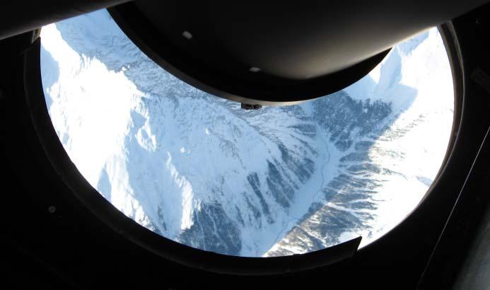
 from Italy (Po-valley) to Oberpfaffenhofen crossing the Alpes per measurement (18 accumulated laser pulses) 1.")
20 Surface Returns on A2D Mie Receiver per observation (630 accumulated laser pulses) Flight on , (9.2 km flight altitude) from Italy (Po-valley) to Oberpfaffenhofen crossing the Alpes per measurement (18 accumulated laser pulses) 1.5 km clouds 4 km mountains A2D resolution: 315 m vertical resolution (2.1 µs) one measurement: 18 accumulated laser pulses (P=20) one observation: 630 accumulated laser pulses (N=35)
 from Italy (Po-valley) to Oberpfaffenhofen crossing the Alpes obs obs obs Satellite: 616 km, 3 observations over 200 km à 50 km (7sec) 16:00-16:30 A2D resolution: 315 m vertical")
21 Surface Returns on A2D Rayleigh Receiver A2D: 616 km, 140 observations = 2800 measurements (à 20 pulses) Flight on , (9.2 km flight altitude) from Italy (Po-valley) to Oberpfaffenhofen crossing the Alpes obs obs obs Satellite: 616 km, 3 observations over 200 km à 50 km (7sec) 16:00-16:30 A2D resolution: 315 m vertical resolution (2.1 µs) one measurement: 18 accumulated laser pulses (P=20) one observation: 630 accumulated laser pulses (N=35)


22 DLR Falcon 20 and HALO (High Altitude and Long Range Research Aircraft, modified Gulfstream G550) in April 2006 Outlook on ADM-Aeolus Campaign Activities HALO aircraft delivery to DLR in November Further 2 airborne campaigns in 2008/09 planned with the A2D and 2-µm wind lidar DLR intends to support ADM-Aeolus Cal/Val activities in 2009/2010 with ground-based campaign with the A2D, other lidars, windprofiler radar and radiosonde at DWD Lindenberg airborne campaigns with Falcon or HALO aircraft with A2D, 2-µm wind lidar and other additional payloads
23 Other Issues ADM-Aeolus Workshop in Sep 2006 ADM-Aeolus Follow-on under consideration ADM-Aeolus Science Report printing in preparation


24 LIDAR Instruments for Earth Observation Missions ADM-Aeolus/ALADIN ESA, launch 2009/10 wind profiles, aerosol, clouds Calipso/CALIOP NASA/CNES, launched 2006 EarthCARE/ATLID ESA/JAXA, launch 2013 aerosol and clouds aerosol and clouds IceSAT/GLAS NASA, launched 2003 elevation, aerosol and clouds Study on Cloud and Aerosols Lidar database including CALIOP, ALADIN, ATLID Future Lidar Instruments, e.g. 9th International Winds Workshop, Annapolis, USA for CO2, clouds AprilA-SCOPE 2008
25 Conclusions Accurate wind profile observations are needed to improve NWP and climate analysis A feasible concept for a demonstrator has been developed and is being implemented as the second Earth Explorer Core Mission Cal/Val Announcement of Opportunity (and science AO later) Various scientific and campaign activities are on going in parallel to the technical activities ADM-Aeolus launch: late 2009 Adaptation of ADM-Aeolus for operational use is being studied Listening to the workshop presentations it seems everybody is waiting for ADM-Aeolus appearing http:
26
ADM-Aeolus ESA s Wind Lidar Mission and its spin-off aerosol profile products
 ADM-Aeolus ESA s Wind Lidar Mission and its spin-off aerosol profile products A. Dehn, A.G. Straume, A. Elfving, F. de Bruin, T. Kanitz, D. Wernham, D. Schuettemeyer, F. Buscaglione, W. Lengert European
Spaceborne Wind Lidar Observations by Aeolus Data Products and Pre-Launch Validation with an Airborne Instrument
 DRAGON 3 Project ID 10532 Cal/Val Spaceborne Wind Lidar Observations by Aeolus Data Products and Pre-Launch Validation with an Airborne Instrument Reitebuch Oliver, Lemmerz Christian, Marksteiner Uwe,
ACTIVITIES IN SUPPORT OF THE DOPPLER WIND LIDAR PROFILING MISSION ADM-AEOLUS
 ACTIVITIES IN SUPPORT OF THE DOPPLER WIND LIDAR PROFILING MISSION ADM-AEOLUS Paul Ingmann, Martin Endemann, and the Members of the ADM-Aeolus Mission Advisory Group (ADMAG) 1 European Space Research and
Aerosol and cloud related products by ESA s Aeolus mission
 Aerosol and cloud related products by ESA s Aeolus mission Stefano Casadio 1, Anne Grete Straume 2, Christophe Caspar 2 1 IDEAS/SERCO, 2 ESA Anne.Straume@esa.int, Stefano.Casadio@esa.int, Christope.Caspar@esa.int
ADM-AEOLUS - ESA'S WIND LIDAR MISSION AND ITS CONTRIBUTION TO NUMERICAL WEATHER PREDICTION
 ADM-AEOLUS - ESA'S WIND LIDAR MISSION AND ITS CONTRIBUTION TO NUMERICAL WEATHER PREDICTION Paul Ingmann, Anne Grete Straume-Lindner and the members of the study teams 1 ESA-ESTEC, PO Box 299, 2200 AG Noordwijk,
Aeolus ESA s Wind Lidar Mission: Objectives, Design & Status
 Aeolus ESA s Wind Lidar Mission: Objectives, Design & Status Anne Grete Straume on behalf of Anders Elfving European Space Agency/ESTEC Working Group on Space-based Lidar Winds Boulder, 28/04/2015 Atmospheric
SCIENTIFIC PREPARATIONS FOR AEOLUS AND AEOLUS FOLLOW-ON
 SCIENTIFIC PREPARATIONS FOR AEOLUS AND AEOLUS FOLLOW-ON Ad.Stoffelen@KNMI.nl, Gert-Jan Marseille, Jos de Kloe, and Karim Houchi (KNMI), Heiner Körnich (MISU), Nedjeljka Žagar (NCAR) KNMI Postbus 201, 3730
DEVELOPMENT OF ADM-AEOLUS PORTABLE LEVEL 2B WIND RETRIEVAL SOFTWARE ABSTRACT
 DEVELOPMENT OF ADM-AEOLUS PORTABLE LEVEL 2B WIND RETRIEVAL SOFTWARE Jos de Kloe 1, Gert-Jan Marseille 1, Ad Stoffelen 1, Karim Houchi 1, David G.H. Tan 2, Erik Andersson 2, Paul Poli 3, Marie-Laure Denneulin
VAMP. Vertical Aeolus Measurement Positioning. Gert-Jan Marseille, Ad Stoffelen, Karim Houchi, Jos de Kloe (KNMI) Heiner Körnich (MISU)
 Heiner Körnich (MISU)") VAMP Vertical Aeolus Measurement Positioning Gert-Jan Marseille, Ad Stoffelen, Karim Houchi, Jos de Kloe (KNMI) Heiner Körnich (MISU) (to optimize Harald its vertical Schyberg sampling) (MetNo) ADM vertical
VAMP Vertical Aeolus Measurement Positioning Gert-Jan Marseille, Ad Stoffelen, Karim Houchi, Jos de Kloe (KNMI) Heiner Körnich (MISU) (to optimize Harald its vertical Schyberg sampling) (MetNo) ADM vertical
Approved Possible future atmospheric Earth Explorer missions
 Approved Possible future atmospheric Earth Explorer missions Jörg Langen, Paul Ingmann, Dulce Lajas, Anne-Grete Straume Mission Science Division, ESA/ESTEC Noordwijk, The Netherlands European satellites
Algorithm Baseline for L1 Product and Calibration
 Algorithm Baseline for L1 Product and Calibration Oliver Reitebuch Uwe Marksteiner, Karsten Schmidt Dorit Huber, Ines Nikolaus Alain Dabas, Pauline Martinet in close cooperation with ESA, Airbus Defense
LAUNCH Concept. Lindenberg Observatory
 Concept Lindenberg Observatory LAUNCH-2005 International Lindenberg Campaign for Assessment of Humidity- and Cloud- Profiling Systems and its Impact on High-Resolution Modelling Objectives Basic Techniques
Airborne wind lidar observations in the North Atlantic in preparation for the ADM-Aeolus validation
 Airborne wind lidar observations in the North Atlantic in preparation for the ADM-Aeolus validation 18 th Coherent Laser Radar Conference, Boulder, CO, USA O. Reitebuch 1, Ch. Lemmerz 1, U. Marksteiner
Impact of airborne Doppler lidar observations on ECMWF forecasts
 from Newsletter Number 3 Autumn 27 METEOROLOGY Impact of airborne Doppler lidar observations on ECMWF forecasts doi:.2957/q8phxvzpzx This article appeared in the Meteorology section of ECMWF Newsletter
estec Aeolus Science and CAL/VAL Workshop ESA/ESRIN, Frascati, February 2015 Workshop Summary
 estec European Space Research and Technology Centre Keplerlaan 1 2201 AZ Noordwijk The Netherlands T +31 (0)71 565 6565 F +31 (0)71 565 6040 www.esa.int Aeolus Science and CAL/VAL Workshop ESA/ESRIN, Frascati,
Aeolus ESA s Wind Lidar Mission: Technical Status & Latest Results
 Aeolus ESA s Wind Lidar Mission: Technical Status & Latest Results Anders Elfving Project Manager European Space Agency/ESTEC Aeolus Cal/Val Workshop Meteo France, Toulouse, 28/03/2017 ESA UNCLASSIFIED
Sentinel-5 Precursor: Preparing the first Copernicus Atmospheric Mission
 Sentinel-5 Precursor: Preparing the first Copernicus Atmospheric Mission Herbert Nett 1, Kevin McMullan 1, Paul Ingmann 1, Thorsten Fehr 2 (1) ESA/ESTEC, Keplerlaan 1, NL-2201 AZ Noordwijk (2) ESA/ESRIN,
IPETSUP The ESA Aeolus mission
 IPETSUP-5 5.3 The ESA Aeolus mission Stephen English ECMWF stephen.english@ecmwf.int 1 ECMWF February 9, 2019 Aeolus ESA Earth Explorer Core Mission Chosen in 1999 Part of ESA s Living Planet Programme
Airborne direct-detection and coherent wind lidar measurements along the east coast of Greenland in 2009 supporting ESA s Aeolus mission
 Airborne direct-detection and coherent wind lidar measurements along the east coast of Greenland in 2009 supporting ESA s Aeolus mission Uwe Marksteiner a, Oliver Reitebuch a, Stephan Rahm a, Ines Nikolaus
LAUNCH Concept. Lindenberg Observatory
 Concept Lindenberg Observatory LAUNCH-2005 International Lindenberg Campaign for Assessment of Humidity- and Cloud- Profiling Systems and its Impact on High-Resolution Modelling Objectives Basic Techniques
THE ATMOSPHERIC DYNAMICS MISSION. P. Ingmann and J. Fuchs (*) and the members of the ADMAG 1 ABSTRACT
 and the members of the ADMAG 1 ABSTRACT") THE ATMOSPHERIC DYNAMICS MISSION P. Ingmann and J. Fuchs (*) and the members of the ADMAG 1 (*) ESA/ESTEC, P.O. Box 299, NL-2200 AG Noordwijk, The Netherlands ABSTRACT The primary aim of the Earth Explorer
THE ATMOSPHERIC DYNAMICS MISSION P. Ingmann and J. Fuchs (*) and the members of the ADMAG 1 (*) ESA/ESTEC, P.O. Box 299, NL-2200 AG Noordwijk, The Netherlands ABSTRACT The primary aim of the Earth Explorer
The European Wind Profiler Network CWINDE Problems and Prospects
 The European Wind Profiler Network CWINDE Problems and Prospects Volker Lehmann Deutscher Wetterdienst GB Forschung und Entwicklung Meteorologisches Observatorium Lindenberg Volker.Lehmann@dwd.de but first...
The EarthCARE mission: An active view on aerosols, clouds and radiation
 The EarthCARE mission: An active view on aerosols, clouds and radiation T. Wehr, T. Fehr, P. Ingmann, J. v. Bismarck ESRIN, Frascati, Italy 20/10/2015 EARTH Clouds, Aerosols and Radiation Explorer EarthCARE
STATUS OF THE DOPPLER WIND LIDAR PROFILING MISSION ADM-AEOLUS
 STATUS OF THE DOPPLER WIND LIDAR PROFILING MISSION ADM-AEOLUS Paul Ingmann, Martin Endemann, and the Members of the ADM-Aeolus Mission Advisory Group 1 Directorate of Earth Observation Programmes, European
ON THE NEEDS, REQUIREMENTS AND FEASIBILITY OF A SPACE-BORNE WIND PROFILER
 ON THE NEEDS, REQUIREMENTS AND FEASIBILITY OF A SPACE-BORNE WIND PROFILER P. Ingmann (1), A. Stoffelen (2), L. Isaksen (3) and G.-J. Marseille (2) (1) ESA/ESTEC, P.O. Box 299, NL-2200 AG Noordwijk, The
AEROSOL LIDAR ACTIVITIES AT ECMWF: STATUS AND PLANS
 AEROSOL LIDAR ACTIVITIES AT ECMWF: STATUS AND PLANS Angela Benedetti & Julie Letrerte-Danczak ECMWF In collaboration with: Marijana Crepulja, Martin Suttie, Mohamed Daouhi and Luke Jones Scientific motivation
The Green-OAWL (GrOAWL) Airborne Demonstrator for the ATHENA-OAWL Mission Concept: System Progress and Flight Plans
 Airborne Demonstrator for the ATHENA-OAWL Mission Concept: System Progress and Flight Plans") The Green-OAWL (GrOAWL) Airborne Demonstrator for the ATHENA-OAWL Mission Concept: System Progress and Flight Plans International Winds Working Group Workshop 27 June 1 July 2016 Monterey, CA Sara Tucker
The Green-OAWL (GrOAWL) Airborne Demonstrator for the ATHENA-OAWL Mission Concept: System Progress and Flight Plans International Winds Working Group Workshop 27 June 1 July 2016 Monterey, CA Sara Tucker
ADM-Aeolus Science and Cal/Val Workshop
 ADM-Aeolus Science and Cal/Val Workshop ESA ESRIN, Frascati, ITALY 10 13 February 2015 THE ALADIN INSTRUMENT AND ITS ON-GROUND CHARACTERISATION O. Lecrenier, F. Fabre, J. Lochard Airbus Defense & Space
WLS70: A NEW COMPACT DOPPLER WIND LIDAR FOR BOUNDARY LAYER DYNAMIC STUDIES.
 WLS70: A NEW COMPACT DOPPLER WIND LIDAR FOR BOUNDARY LAYER DYNAMIC STUDIES. VALIDATION RESULTS AND INTERCOMPARISON IN THE FRAME OF THE 8TH CIMO-WMO CAMPAIGN. S. Lolli 1, L.Sauvage 1, M. Boquet 1, 1 Leosphere,
The impact of airborne wind and water vapour lidar measurements on ECMWF analyses and forecasts
 The impact of airborne wind and water vapour lidar measurements on ECMWF analyses and forecasts Martin Weissmann, Andreas Dörnbrack, Gerhard Ehret, Christoph Kiemle, Roland Koch, Stephan Rahm, Oliver Reitebuch
2.5 COMPARING WATER VAPOR VERTICAL PROFILES USING CNR-IMAA RAMAN LIDAR AND CLOUDNET DATA
 2.5 COMPARING WATER VAPOR VERTICAL PROFILES USING CNR-IMAA RAMAN LIDAR AND CLOUDNET DATA Lucia Mona*, 1, Aldo Amodeo 1, Carmela Cornacchia 1, Fabio Madonna 1, Gelsomina Pappalardo 1 and Ewan O Connor 2
Aeolus CAL/VAL Rehearsal Workshop Summary
 Aeolus CAL/VAL Rehearsal Workshop Summary Météo-France, Toulouse, France Tuesday 28 March Thursday 30 March 2017 Table of Contents Workshop Summary by E. Källén... 3 Individual session summaries:... 6
The EarthCARE mission: An active view on aerosols, clouds and radiation
 The EarthCARE mission: An active view on aerosols, clouds and radiation T. Wehr, P. Ingmann, T. Fehr Heraklion, Crete, Greece 08/06/2015 EarthCARE is ESA s sixths Earth Explorer Mission and will be implemented
The AEOLUS Mission - In Orbit Commissioning and Verification
 The AEOLUS Mission - In Orbit Commissioning and Verification ADM-Aeolus CAL/VAL Workshop, ESRIN P McGoldrick, J Brewster, J Marshall, F Fabre Airbus Defence and Space, UK and France 12 th February 2015
REVISION OF THE STATEMENT OF GUIDANCE FOR GLOBAL NUMERICAL WEATHER PREDICTION. (Submitted by Dr. J. Eyre)
") WORLD METEOROLOGICAL ORGANIZATION Distr.: RESTRICTED CBS/OPAG-IOS (ODRRGOS-5)/Doc.5, Add.5 (11.VI.2002) COMMISSION FOR BASIC SYSTEMS OPEN PROGRAMME AREA GROUP ON INTEGRATED OBSERVING SYSTEMS ITEM: 4 EXPERT
WORLD METEOROLOGICAL ORGANIZATION Distr.: RESTRICTED CBS/OPAG-IOS (ODRRGOS-5)/Doc.5, Add.5 (11.VI.2002) COMMISSION FOR BASIC SYSTEMS OPEN PROGRAMME AREA GROUP ON INTEGRATED OBSERVING SYSTEMS ITEM: 4 EXPERT
Characterizing the role of diabatic processes for the modification of mid-latitude Rossby waves and Jetstream winds
 Characterizing the role of diabatic processes for the modification of mid-latitude Rossby waves and Jetstream winds Andreas Schäfler 1, George Craig 2, Andreas Dörnbrack 1, Florian Harnisch 4, Uwe Marksteiner
Rayleigh-Brillouin Scattering Experiment with Atmospheric Lidar from a Mountain Observatory
 Rayleigh-Brillouin Scattering Experiment with Atmospheric Lidar from a Mountain Observatory Oliver Reitebuch, Christian Lemmerz, Engelbert Nagel, Benjamin Witschas Institut für Physik der Atmosphäre intensity
Atmospheric Lidar The Atmospheric Lidar (ATLID) is a high-spectral resolution lidar and will be the first of its type to be flown in space.
 is a high-spectral resolution lidar and will be the first of its type to be flown in space.") www.esa.int EarthCARE mission instruments ESA s EarthCARE satellite payload comprises four instruments: the Atmospheric Lidar, the Cloud Profiling Radar, the Multi-Spectral Imager and the Broad-Band Radiometer.
www.esa.int EarthCARE mission instruments ESA s EarthCARE satellite payload comprises four instruments: the Atmospheric Lidar, the Cloud Profiling Radar, the Multi-Spectral Imager and the Broad-Band Radiometer.
Height correction of atmospheric motion vectors (AMVs) using lidar observations
 using lidar observations") Height correction of atmospheric motion vectors (AMVs) using lidar observations Kathrin Folger and Martin Weissmann Hans-Ertel-Centre for Weather Research, Data Assimilation Branch Ludwig-Maximilians-Universität
Height correction of atmospheric motion vectors (AMVs) using lidar observations Kathrin Folger and Martin Weissmann Hans-Ertel-Centre for Weather Research, Data Assimilation Branch Ludwig-Maximilians-Universität
Tr a n s r e g i o n a l C o l l a b o r a t i v e Re s e a r c h C e n t r e TR 172
 Tr a n s r e g i o n a l C o l l a b o r a t i v e Re s e a r c h C e n t r e TR 172 ArctiC Amplification: Climate Relevant Atmospheric and SurfaCe Processes, and Feedback Mechanisms (AC) 3 Towards a better
Validation of ADM-Aeolus L2 aerosol and cloud product employing advanced ground-based lidar measurements (VADAM)
") Validation of ADM-Aeolus L2 aerosol and cloud product employing advanced ground-based lidar measurements (VADAM) V. Amiridis, National Observatory of Athens, Greece U. Wandinger, TROPOS-Leibniz Institute
Validation of ADM-Aeolus L2 aerosol and cloud product employing advanced ground-based lidar measurements (VADAM) V. Amiridis, National Observatory of Athens, Greece U. Wandinger, TROPOS-Leibniz Institute
Course outline, objectives, workload, projects, expectations
 Course outline, objectives, workload, projects, expectations Introductions Remote Sensing Overview Elements of a remote sensing observing system 1. platform (satellite, surface, etc) 2. experimental design
Contributions of DLR to DEEPWAVE-NZ
 Contributions of DLR to DEEPWAVE-NZ Hans Schlager, Markus Rapp, Bernd Kaifler, Andreas Dörnbrack DLR Oberpfaffenhofen Institut für Physik der Atmosphäre DLR contribution integrated in the BMBF Research
Overview and Status of ESA Earth Observation Programmes
 Overview and Status of ESA Earth Observation Programmes Maurice Borgeaud, ESA Head of the Science, Applications and Future Technologies Department Directorate of Earth Observation Programmes ADM-Aeolus
LUAMI CAMPAIGN FALL 2008 SUMMARY
 World Meteorological Organization CIMO-XIV/INF. 5 COMMISSION FOR INSTRUMENTS AND METHODS OF OBSERVATION FOURTEENTH SESSION Geneva, Switzerland 7 to 14 December 2006 Submitted by: Date: Original Language:
Global observations from CALIPSO
 Global observations from CALIPSO Dave Winker, Chip Trepte, and the CALIPSO team NRL, Monterey, 27-29 April 2010 Mission Overview Features: Two-wavelength backscatter lidar First spaceborne polarization
OPERA: Operational Programme for the Exchange of Weather Radar Information
 OPERA: Operational Programme for the Exchange of Weather Radar Information ALADIN-HIRLAM workshop, Toulouse Maud Martet 26-28 April 2016 OPERA: An EUMETNET Project EUMETNET: EIG of 31 European National
The ADM-Aeolus wind retrieval algorithms
 Tellus (8), 6A, 191 Printed in Singapore. All rights reserved C 7 The Authors Journal compilation C 7 Blackwell Munksgaard TELLUS The ADM-Aeolus wind retrieval algorithms By DAVID G. H. TAN 1, ERIK ANDERSSON
EUMETSAT SAF NETWORK. Lothar Schüller, EUMETSAT SAF Network Manager
 1 EUMETSAT SAF NETWORK Lothar Schüller, EUMETSAT SAF Network Manager EUMETSAT ground segment overview METEOSAT JASON-2 INITIAL JOINT POLAR SYSTEM METOP NOAA SATELLITES CONTROL AND DATA ACQUISITION FLIGHT
Spaceborne Aerosol and Ozone Lidars for Air Quality Applications
 Spaceborne Aerosol and Ozone Lidars for Air Quality Applications Rich Ferrare Chris Hostetler Ed Browell John Hair NASA Langley Research Center Detlef Müller Institute for Tropospheric Research, Leipzig
Recent lidar measurements from AWIPEV
 Recent lidar measurements from AWIPEV By Christoph Ritter AWI Potsdam Aerosol and BL measurements Aims aerosol: (remote sensing sun/star-photometer, Raman lidar) Continue long-term measurements Participate
microwave profiler: comparisons and synergies
 Water vapour Raman lidar and microwave profiler: comparisons and synergies F. Madonna, A. Amodeo, C. Cornacchia, G. D Amico, L. Mona, G. Pappalardo Istituto di Metodologie per l Analisi Ambientale CNR-IMAA,
Deutscher Wetterdienst
 Deutscher Wetterdienst Comparison of wind profiler radar measurements with Doppler wind lidar profiles measurements at the Lindenberg GRUAN site Bernd Stiller, Ronny Leinweber, Volker Lehmann DWD - Deutscher
Ground-based Validation of spaceborne lidar measurements
 Ground-based Validation of spaceborne lidar measurements Ground-based Validation of spaceborne lidar measurements to make something officially acceptable or approved, to prove that something is correct
IASI Level 2 Product Processing
 IASI Level 2 Product Processing Dieter Klaes for Peter Schlüssel Arlindo Arriaga, Thomas August, Xavier Calbet, Lars Fiedler, Tim Hultberg, Xu Liu, Olusoji Oduleye Page 1 Infrared Atmospheric Sounding
WWRP RDP COPS Coordination Structure Science Questions Status Outlook
 WWRP RDP COPS Volker Wulfmeyer Institute of Physics and Meteorology University of Hohenheim Stuttgart, Germany, the COPS International Science Steering Committee, and the D-PHASE Steering Committee Coordination
VERIFICATION OF MERIS LEVEL 2 PRODUCTS: CLOUD TOP PRESSURE AND CLOUD OPTICAL THICKNESS
 VERIFICATION OF MERIS LEVEL 2 PRODUCTS: CLOUD TOP PRESSURE AND CLOUD OPTICAL THICKNESS Rene Preusker, Peter Albert and Juergen Fischer 17th December 2002 Freie Universitaet Berlin Institut fuer Weltraumwissenschaften
Observation minus Background Statistics for Humidity and Temperature from Raman lidar, microwave radiometer and COSMO-2
 Federal Department of Home Affairs FDHA Federal Office of Meteorology and Climatology MeteoSwiss Observation minus Background Statistics for Humidity and Temperature from Raman lidar, microwave radiometer
EUMETNET Statement for the EASA Workshop Volcanic Ash Cloud: Detection, Observation, Measurement, Modelling The Way Forward
 EUMETNET Statement for the EASA Workshop Volcanic Ash Cloud: Detection, Observation, Measurement, Modelling The Way Forward Cologne, 21 st June 2010 Background GIE EUMETNET (the network of European Meteorological
The Copernicus Sentinel-5 Mission: Daily Global Data for Air Quality, Climate and Stratospheric Ozone Applications
 SENTINEL-5 The Copernicus Sentinel-5 Mission: Daily Global Data for Air Quality, Climate and Stratospheric Ozone Applications Yasjka Meijer RHEA for ESA, Noordwijk, NL 15/04/2016 Co-Authors: Jörg Langen,
Report from the PDP working group
 Report from the PDP working group Craig Bishop, Pat Harr, Shuhei Maeda, John Methven, Mark Rodwell, Istvan Szunyogh, Olivier Talagrand, Heini Wernli ICSC11 Meeting July 2013 PDP mission Main task of the
Merci. Measurement Error and Correlation Impact on the Atmospheric Dynamics Mission. Draft Task 2 report
 Merci Measurement Error and Correlation Impact on the Atmospheric Dynamics Mission Draft Task 2 report ESA Reference: FS/0304/PI/pi, version 1.1 (RFQ/3-9992/01/NL/MM) Ad Stoffelen, KNMI Måns Håkansson,
Julia Figa-Saldaña & Klaus Scipal
 Julia Figa-Saldaña & Klaus Scipal julia.figa@eumetsat.int klaus.scipal@esa.int Meeting, Outline MetOp/EPS status MetOp/EPS Second Generation status 2016 scatterometer conference Other European ocean programme
Results from the Atmosphere & Climate projects in Dragon-3
 Results from the Atmosphere & Climate projects in Dragon-3 R.J. van der A, J. Bai, A. Ding, N. Hao, Y. Xue, C. Varotsos, R. Ma, S. Loiselle, F. Huang, V. Sofieva, Y. Liu, H. Boesch, Z. Liu, O. Reitebuch,
Mode-S EHS data usage in the meteorological domain:
 Mode-S EHS data usage in the meteorological domain: derivation of Wind and Temperature observations; and assimilation of these observations in a numerical weather prediction model. Jan Sondij, MBA Senior
Calibration/Validation Experiments for the ADM-Aeolus using the OUC lidar facilities
 Calibration/Validation Experiments for the ADM-Aeolus using the OUC lidar facilities Songhua Wu 1,2 Xiaoquan SONG 1, Guangyao DAI 1,3, Xiaochun ZHAI 1, Bingyi LIU 1, Jintao LIU 1, Qi LIU 1, Hongwei ZHANG
BR-236 February 2005
 BR-236 February 2005 ESA s EARTH OBSERVATION MISSIONS METEOSAT - In 1977 the first of seven Meteosat meteorological satellites was launched to monitor the weather over Europe and Africa. Operational services
Status of the Sentinel-5 Precursor Presented by C. Zehner S5p, S4, and S5 Missions Manager - ESA
 Status of the Sentinel-5 Precursor Presented by C. Zehner S5p, S4, and S5 Missions Manager - ESA European response to global needs: to manage the environment, to mitigate the effects of climate change
Developments in CALIOP Aerosol Products. Dave Winker
 Developments in CALIOP Aerosol Products Dave Winker NASA Langley Research Center Hampton, VA Winker - 1 Outline Level 3 aerosol product (beta-version) Version 4 Level 1 product A few CALIOP assimilation
The Earth Explorer Missions - Current Status
 EOQ N 66 July 2000 meteorology earthnet remote sensing solid earth future programmes Earth Observation Quarterly The Earth Explorer Missions - Current Status G. Mégie (1) and C.J. Readings (2) (1) Institut
NEW CANDIDATE EARTH EXPLORER CORE MISSIONS THEIR IMPORTANCE FOR ATMOSPHERIC SCIENCE AND APPLICATION
 NEW CANDIDATE EARTH EXPLORER CORE MISSIONS THEIR IMPORTANCE FOR ATMOSPHERIC SCIENCE AND APPLICATION P. Ingmann and J. Langen European Space Research and Technology Centre (ESTEC) P.O. Box 299, NL-2200
Application of the sub-optimal Kalman filter to ozone assimilation. Henk Eskes, Royal Netherlands Meteorological Institute, De Bilt, the Netherlands
 Ozone data assimilation and forecasts Application of the sub-optimal Kalman filter to ozone assimilation Henk Eskes, Royal Netherlands Meteorological Institute, De Bilt, the Netherlands Ozone assimilation
Aerosols from Sentinel 3 and EarthCARE missions
 Aerosols from Sentinel 3 and EarthCARE missions Michael Eisinger, Tobias Wehr, Dulce Lajas, Alain Lefebvre European Space Agency Aerosol Observability Workshop 27-29 April 2010 Monterey, CA Page 1 Outline
VAMP Executive Summary
 AE-TN-KNMI-VAMP-ES_v1.0 19 November, 2010 AE-TN-KNMI-VAMP-ES VAMP Executive Summary Version 1.0 Gert-Jan Marseille, KNMI Ad Stoffelen, KNMI Jos de Kloe, KNMI Karim Houchi, KNMI Harald Schyberg, MetNo Heiner
Abstract 1 INTRODUCTION OF WATER CLOUD PARAMETERS 1R.4 RADAR-LIDAR SYNERGY FOR SPACE-BASED RETRIEVAL
 1R.4 RADAR-LIDAR SYNERGY FOR SPACE-BASED RETRIEVAL OF WATER CLOUD PARAMETERS Gregory May Herman Russchenberg Oleg Krasnov Delft University of Technology, IRCTR, Delft, The Netherlands Abstract Knowledge
Developments on air quality modeling, Prof. Dr. Hennie Kelder Royal Netherlands Meteorological Inst KNMI University of Technology, Eindhoven
 Developments on air quality modeling, satellite observations and services in Europ Prof. Dr. Hennie Kelder Royal Netherlands Meteorological Inst KNMI University of Technology, Eindhoven GMES: Global Monitoring
State of the art of wind forecasting and planned improvements for NWP Helmut Frank (DWD), Malte Mülller (met.no), Clive Wilson (UKMO)
, Malte Mülller (met.no), Clive Wilson (UKMO)") State of the art of wind forecasting and planned improvements for NWP Helmut Frank (DWD), Malte Mülller (met.no), Clive Wilson (UKMO) thanks to S. Bauernschubert, U. Blahak, S. Declair, A. Röpnack, C.
State of the art of wind forecasting and planned improvements for NWP Helmut Frank (DWD), Malte Mülller (met.no), Clive Wilson (UKMO) thanks to S. Bauernschubert, U. Blahak, S. Declair, A. Röpnack, C.
Lidar and radiosonde measurement campaign for the validation of ENVISAT atmospheric products
 Lidar and radiosonde measurement campaign for the validation of ENVISAT atmospheric products V. Cuomo, G. Pappalardo, A. Amodeo, C. Cornacchia, L. Mona, M. Pandolfi IMAA-CNR Istituto di Metodologie per
Remote sensing with FAAM to evaluate model performance
 Remote sensing with FAAM to evaluate model performance YOPP-UK Workshop Chawn Harlow, Exeter 10 November 2015 Contents This presentation covers the following areas Introduce myself Focus of radiation research
European ceilometer and lidar networks for aerosol profiling and aviation safety the German contribution
 European ceilometer and lidar networks for aerosol profiling and aviation safety the German contribution Werner Thomas Deutscher Wetterdienst (DWD) Hohenpeissenberg Meteorological Observatory www.dwd.de/ceilomap
IMPACT OF IASI DATA ON FORECASTING POLAR LOWS
 IMPACT OF IASI DATA ON FORECASTING POLAR LOWS Roger Randriamampianina rwegian Meteorological Institute, Pb. 43 Blindern, N-0313 Oslo, rway rogerr@met.no Abstract The rwegian THORPEX-IPY aims to significantly
Updates on CMA FENGYUN Meteorological Satellite Programs
 Updates on CMA FENGYUN Meteorological Satellite Programs Peng ZHANG National Satellite Meteorological Center, China Meteorological Administration (NSMC/CMA) 29 Nov. - 5 Dec. 2017, Darmstadt, Germany 1.
Operational atmospheric chemistry monitoring,
 Operational atmospheric chemistry monitoring, European developments 2010-2030 Hennie Kelder on behalf of Capacity consortium and Eumetsat post-eps study team KNMI, University of Technology Eindhoven Outline
Prospects for radar and lidar cloud assimilation
 Prospects for radar and lidar cloud assimilation Marta Janisková, ECMWF Thanks to: S. Di Michele, E. Martins, A. Beljaars, S. English, P. Lopez, P. Bauer ECMWF Seminar on the Use of Satellite Observations
Status of ESA EO Programmes
 Status of ESA EO Programmes 54 th ESSC Plenary Meeting 24 November 2017 Maurice Borgeaud, ESA Head of the ESA Earth Observation Science, Applications and Climate Department Issue/Revision: 0.0 Reference:
Deutscher Wetterdienst
 LUAMI Campaign - Fall 2008 Lindenberg campaign for Upper-Air Methods Intercomparison Dirk A.M. Engelbart / F. Immler Introduction Remote sensing @ MOL/RAO Relation to WMO (GVaP, CIMO) Example of current
STATUS AND DEVELOPMENT OF SATELLITE WIND MONITORING BY THE NWP SAF
 STATUS AND DEVELOPMENT OF SATELLITE WIND MONITORING BY THE NWP SAF Mary Forsythe (1), Antonio Garcia-Mendez (2), Howard Berger (1,3), Bryan Conway (4), Sarah Watkin (1) (1) Met Office, Fitzroy Road, Exeter,
BJORN STEVENS MAX PLANCK INSTITUTE FOR METEOROLOGY, HAMBURG GERMANY
 PROPOSAL FOR AN ISSI (BERN) INTERNATIONAL TEAM BJORN STEVENS MAX PLANCK INSTITUTE FOR METEOROLOGY, HAMBURG GERMANY Abstract The aim of the International Team will be to advance understanding of what controls
Exploitation of ground based GPS for Climate and Numerical Weather Prediction applications COST action 716
 Exploitation of ground based GPS for Climate and Numerical Weather Prediction applications COST action 716 COST Objectives and status of COST 716 Overview of work packages / projects Near real-time demonstration
ESA AO/1-5467/07/NL/HE A SPONTANEOUS RAYLEIGH-BRILLOUIN SCATTERING EXPERIMENT FOR THE CHARACTERIZATION OF ATMOSPHERIC LIDAR BACKSCATTER
 A SPONTANEOUS RAYLEIGH-BRILLOUIN LIDAR BACKSCATTER Technical Note 4, Part 3 version 5; 11-Dec-2009 RB scattering uncertainty effects on ADM-Aeolus winds Jos de Kloe and Ad Stoffelen KNMI, Royal Netherlands
CAPACITY* OPERATIONAL ATMOSPHERIC CHEMISTRY MONITORING MISSIONS
 CAPACITY* OPERATIONAL ATMOSPHERIC CHEMISTRY MONITORING MISSIONS 2010-2020 Michiel van Weele Atmospheric Composition Division, Climate Department KNMI The Netherlands * Composition of the Atmosphere: Progress
MSG system over view
 MSG system over view 1 Introduction METEOSAT SECOND GENERATION Overview 2 MSG Missions and Services 3 The SEVIRI Instrument 4 The MSG Ground Segment 5 SAF Network 6 Conclusions METEOSAT SECOND GENERATION
CNES Activity Report. Patrice Henry - CNES WGCV Plenary # 41 Tokyo Sept. 5-7, Working Group on Calibration and Validation
 Activity Report Patrice Henry - Tokyo Sept. 5-7, 2016 Working Group on Calibration and Validation SUMMARY Calibration Monitoring of in-flight Missions Preparation of future Missions Involvement in CEOS/WGCV
Observations of Arctic snow and sea ice thickness from satellite and airborne surveys. Nathan Kurtz NASA Goddard Space Flight Center
 Observations of Arctic snow and sea ice thickness from satellite and airborne surveys Nathan Kurtz NASA Goddard Space Flight Center Decline in Arctic sea ice thickness and volume Kwok et al. (2009) Submarine
Climate & Earth System Science. Introduction to Meteorology & Climate. Chapter 05 SOME OBSERVING INSTRUMENTS. Instrument Enclosure.
 Climate & Earth System Science Introduction to Meteorology & Climate MAPH 10050 Peter Lynch Peter Lynch Meteorology & Climate Centre School of Mathematical Sciences University College Dublin Meteorology
The CLARE 98 Campaign and Its Context
 the clare 98 campaign The CLARE 98 Campaign and Its Context J.P.V. Poiares Baptista ESA Directorate of Technical and Operational Support, ESTEC, Noordwijk, The Netherlands A.J. Illingworth Department of
Remote sensing of meteorological conditions at airports for air quality issues
 Remote sensing of meteorological conditions at airports for air quality issues Stefan Emeis, Klaus Schäfer Institute for Meteorology and Climate Research Atmospheric Environmental Research (IMK-IFU) Forschungszentrum
Simulation testbed for the assessment of space-based wind measuring systems
 Simulation testbed for the assessment of space-based wind measuring systems S. A. Wood, G. D. Emmitt and Steve Greco Simpson Weather Associates, 809 E. Jefferson St., Charlottesville, VA 22902 ABSTRACT
IMPACT ASSESSMENT OF A DOPPLER WIND LIDAR IN SPACE ON ATMOSPHERIC ANALYSES AND NUMERICAL WEATHER PREDICTION
 IMPACT ASSESSMENT OF A DOPPLER WIND LIDAR IN SPACE ON ATMOSPHERIC ANALYSES AND NUMERICAL WEATHER PREDICTION G. J. Marseille, A. Stoffelen, F. Bouttier*, C. Cardinali*, S. de Haan, and D. Vasiljevic* *
esa ACE+ An Atmosphere and Climate Explorer based on GPS, GALILEO, and LEO-LEO Occultation Per Høeg (AIR/DMI) Gottfried Kirchengast (IGAM/UG)
 Gottfried Kirchengast (IGAM/UG)") ACE+ An Atmosphere and Climate Explorer based on GPS, GALILEO, and LEO-LEO Occultation Per Høeg (AIR/DMI) Gottfried Kirchengast (IGAM/UG) OPAC-1, September, 2002 1 Objectives Climate Monitoring global
ACE+ An Atmosphere and Climate Explorer based on GPS, GALILEO, and LEO-LEO Occultation Per Høeg (AIR/DMI) Gottfried Kirchengast (IGAM/UG) OPAC-1, September, 2002 1 Objectives Climate Monitoring global