Aeolus ESA s Wind Lidar Mission: Objectives, Design & Status
|
|
|
- Augustus Flowers
- 6 years ago
- Views:
Transcription


1 Aeolus ESA s Wind Lidar Mission: Objectives, Design & Status Anne Grete Straume on behalf of Anders Elfving European Space Agency/ESTEC Working Group on Space-based Lidar Winds Boulder, 28/04/2015
2 Atmospheric Dynamics of the Earth Page 2
3 Aeolus: Mission Objectives Scientific objectives To improve the quality of weather forecasts; To advance our understanding of atmospheric dynamics and climate processes; Explorer objectives Demonstrate space-based Doppler Wind LIDARs potential for operational use. Observation means: Provide global measurements of horizontal wind profiles in the troposphere and lower stratosphere Payload ALADIN: Atmospheric LAser Doppler INstrument Aeolus - ESA's Wind LIDAR Mission Straume Working Group on Scape-based Lidar Winds 28/04/2015 Slide 3

4 Mission Design Mission Parameters Orbit: sun-synchronous Mean altitude: ~400 km Local time: 18:00 ascending node Inclination: 96.97o Repeat cycle: 7 days / 109 orbits Orbits per day: ~16 Mission lifetime: 3 years Page 4

5 Mission Design Page 5
6 Satellite Control Ground station at Salmijärvi (Kiruna) Kiruna ESOC Satellite Control from ESOC Darmstadt (Germany) Aeolus - ESA's Wind LIDAR Mission Straume Working Group on Scape-based Lidar Winds 28/04/2015 Slide 6
7 Data Reception & Processing (1/2) Data reception at Svalbard Svalbard Tromsø Data processing at Tromsø ECMWF ESRIN Wind data assimilation at ECMWF Aeolus - ESA's Wind LIDAR Mission Straume Working Group on Scape-based Lidar Winds 28/04/2015 Slide 7
8 Aeolus: Instrument Data Processing? Wind Velocity AISP L0 L1A L1B L2B v HLOS Data preparation L2A, σ Aeolus - ESA's Wind LIDAR Mission Straume Working Group on Scape-based Lidar Winds 28/04/2015 Slide 8

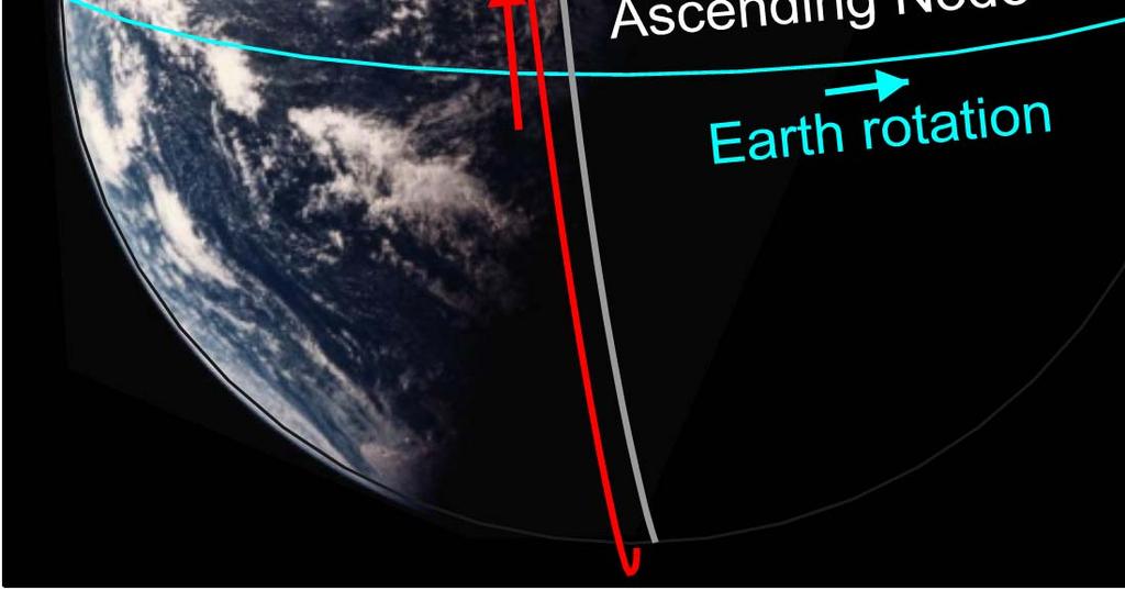
9 Aeolus: Measurement Principle (1/2) Direct detection UV Doppler wind Lidar operating at 355 nm and 50 Hz PRF in continuous mode, with 2 receiver channels Mie receiver to determine winds from aerosol & cloud backscatter Rayleigh receiver to determine winds from molecular backscatter HLOS The line-of-sight is pointing 35 o from Nadir to obtain horizontal backscatter component The line-of-sight is pointing orthogonal to the ground track velocity vector to remove contribution from the satellite velocity Aeolus - ESA's Wind LIDAR Mission Straume Working Group on Scape-based Lidar Winds 28/04/2015 Slide 9
 < 100 m/s 30")


10 Aeolus: Measurement Principle (2/2) < 100 m/s 30 m/s 600 m/s Mie channel: Aerosol/cloud backscatter Imaging technique Rayleigh channel: Molecular backscatter Double-edge technique Aeolus - ESA's Wind LIDAR Mission Straume Working Group on Scape-based Lidar Winds 28/04/2015 Slide 10
11 Aeolus: Observational Requirements PBL Troposphere Stratosphere Vertical domain [km] (30)* Vertical resolution 1 [km] Horizontal domain Global Number of profiles [hour -1 ] >100 Horizontal track data availability > 90% Temporal sampling [hr] 12 [km] Horizontal resolution / integration length 2 15 (target) 100 (threshold) Horizontal sub-sample length [km] km scale Random error (HLOS Component) [m/s] * Systematic error (HLOS component) [m/s] Dynamic Range, HLOS [m/s] ±150 Error Correlation per 100 km < 0.1 Probability of Gross Error [%] 5 Timeliness 3 Length of Observation Dataset [yr] atmospheric samples for Mie & Rayleigh channel with 0.25km minimum vertical resolution 2 L1B data: ~90 km horizontal integration length Aeolus - ESA's Wind LIDAR Mission Straume Working Group on Scape-based Lidar Winds 28/04/2015 Slide 11

12 Aeolus: ALADIN Instrument Transmitlasers Optical Bench Aeolus - ESA's Wind LIDAR Mission Straume Working Group on Scape-based Lidar Winds 28/04/2015 Slide 12
 in two LBO crystals with ~40% efficiency.")
13 Aeolus: ALADIN Laser Transmitter The Master Oscillator is a stable resonator with an endpumped rod. An RTP crystal q-switch is used. Pulses of about 5 mj energy at 1065 nm are generated. Two diode pumped slab amplifiers generate about 350 mj at 50 Hz pulse repetition frequency. These IR pulses are frequency tripled to the UV (355 nm) in two LBO crystals with ~40% efficiency. UV optics to shape and steer the output beam for compatibility with Aladin transmit optics. PLH FM-A during final integration Aeolus - ESA's Wind LIDAR Mission Straume Working Group on Scape-based Lidar Winds 28/04/2015 Slide 13

14 Harmonic Conversion and UV section Aeolus - ESA's Wind LIDAR Mission Straume Working Group on Scape-based Lidar Winds 28/04/2015 Slide 14

15 Aeolus: Major events, Laser Test Experience 2005: Laser Diode Performance 2012: LID on UV Optic Coatings Aeolus - ESA's Wind LIDAR Mission Straume Working Group on Scape-based Lidar Winds 28/04/2015 Slide 15


16 Laser Endurance Test in Vacuum Chamber 150 M shots Aeolus - ESA's Wind LIDAR Mission Straume Working Group on Scape-based Lidar Winds 28/04/2015 Slide 16
 Aeolus -")

17 Optical Bench Assembly (OBA) with Transmit & Receive Optics (TRO) Aeolus - ESA's Wind LIDAR Mission Straume Working Group on Scape-based Lidar Winds 28/04/2015 Slide 17


18 Optical Bench Fluence Test Transmit Optics Laser transmitter Aeolus - ESA's Wind LIDAR Mission Straume Working Group on Scape-based Lidar Winds 28/04/2015 Slide 18


19 ALADIN Satellite Aeolus - ESA's Wind LIDAR Mission Straume Working Group on Scape-based Lidar Winds 28/04/2015 Slide 19
20 Key validation test remaining 1. Instrument Functional Performance Tests (IFP) Aladin level a. Primary and redundant lasers emitting via transmit optics and telescope to On Ground Support Equipment (OGSE). OGSE simulate atmospheric return signal through reception chain and spectrometers. 2. Aladin Electromagnetic Compatibility (EMC) test (Conducted emissions and susceptibility) 3. System level initial functional and performance tests (IST1 & SVT1) 4. Satellite vibration, acoustic and shock tests 5. Satellite EMC test 6. Satellite Thermal Vacuum Test (Tvac) including a. Functional and performance tests for hot and cold cases (IST2&3) b. ALADIN operating at full energy via OGSE 7. System level final functional and performance tests (IST4 & SVT2) Aeolus - ESA's Wind LIDAR Mission Straume Working Group on Scape-based Lidar Winds 28/04/2015 Slide 20
21 Aeolus: Mission Impact for Weather Forecast Aeolus - ESA's Wind LIDAR Mission Straume Working Group on Scape-based Lidar Winds 28/04/2015 Slide 21
22 Aeolus: Mission Impact for Weather Forecast Summary conclusions by two impact studies led by ECMWF and KNMI Especially beneficial in the tropics and at high altitudes HLOS winds provides approximately 75% of the full wind vector information Impact on forecast quality is of the same order as the currently available radiosonde observation network Impact rather insensitive to random wind error variation Even small wind biases can be detrimental, so try to reduce biases! Wind bias calibration efforts will be essential! Aeolus - ESA's Wind LIDAR Mission Straume Working Group on Scape-based Lidar Winds 28/04/2015 Slide 22

23 Conclusions More than 10 years of development challenges Invaluable experience has been gained Aeolus - ESA's Wind LIDAR Mission Straume Working Group on Scape-based Lidar Winds 28/04/2015 Slide 23

24 Conclusions More than 10 years of development challenges Invaluable experience has been gained Laser and LIDAR modifications are very time consuming 16 Aeolus - ESA's Wind LIDAR Mission Straume Working Group on Scape-based Lidar Winds 28/04/2015 Slide 24

25 Conclusions More than 10 years of development challenges Invaluable experience has been gained Laser and LIDAR modifications are very time consuming The mission remains worldwide unique Aeolus - ESA's Wind LIDAR Mission Straume Working Group on Scape-based Lidar Winds 28/04/2015 Slide 25

26 Conclusions More than 10 years of development challenges Invaluable experience has been gained Laser and LIDAR modifications are very time consuming The mission remains worldwide unique Enthusiastic user communities anticipating break-through in weather forecast and climate research Aeolus - ESA's Wind LIDAR Mission Straume Working Group on Scape-based Lidar Winds 28/04/2015 Slide 26

27 Conclusions More than 10 years of development challenges Invaluable experience has been gained Laser and LIDAR modifications are very time consuming The mission remains worldwide unique Enthusiastic user communities anticipating break-through in weather forecast and climate research The Project and the Industrial team committed to complete Aladin by end 2015 and be ready for launch in Aeolus - ESA's Wind LIDAR Mission Straume Working Group on Scape-based Lidar Winds 28/04/2015 Slide 27

28 Important link: Aeolus Living Planet web site: Aeolus - ESA's Wind LIDAR Mission Straume Working Group on Scape-based Lidar Winds 28/04/2015 Slide 28
ADM-Aeolus ESA s Wind Lidar Mission and its spin-off aerosol profile products
 ADM-Aeolus ESA s Wind Lidar Mission and its spin-off aerosol profile products A. Dehn, A.G. Straume, A. Elfving, F. de Bruin, T. Kanitz, D. Wernham, D. Schuettemeyer, F. Buscaglione, W. Lengert European
Aeolus ESA s Wind Lidar Mission: Technical Status & Latest Results
 Aeolus ESA s Wind Lidar Mission: Technical Status & Latest Results Anders Elfving Project Manager European Space Agency/ESTEC Aeolus Cal/Val Workshop Meteo France, Toulouse, 28/03/2017 ESA UNCLASSIFIED
ADM-Aeolus Science and Cal/Val Workshop
 ADM-Aeolus Science and Cal/Val Workshop ESA ESRIN, Frascati, ITALY 10 13 February 2015 THE ALADIN INSTRUMENT AND ITS ON-GROUND CHARACTERISATION O. Lecrenier, F. Fabre, J. Lochard Airbus Defense & Space
Aerosol and cloud related products by ESA s Aeolus mission
 Aerosol and cloud related products by ESA s Aeolus mission Stefano Casadio 1, Anne Grete Straume 2, Christophe Caspar 2 1 IDEAS/SERCO, 2 ESA Anne.Straume@esa.int, Stefano.Casadio@esa.int, Christope.Caspar@esa.int
Spaceborne Wind Lidar Observations by Aeolus Data Products and Pre-Launch Validation with an Airborne Instrument
 DRAGON 3 Project ID 10532 Cal/Val Spaceborne Wind Lidar Observations by Aeolus Data Products and Pre-Launch Validation with an Airborne Instrument Reitebuch Oliver, Lemmerz Christian, Marksteiner Uwe,
ADM-AEOLUS - ESA'S WIND LIDAR MISSION AND ITS CONTRIBUTION TO NUMERICAL WEATHER PREDICTION
 ADM-AEOLUS - ESA'S WIND LIDAR MISSION AND ITS CONTRIBUTION TO NUMERICAL WEATHER PREDICTION Paul Ingmann, Anne Grete Straume-Lindner and the members of the study teams 1 ESA-ESTEC, PO Box 299, 2200 AG Noordwijk,
ADM-Aeolus Progressing Towards Mission Exploitation
 ADM-Aeolus Progressing Towards Mission Exploitation Paul Ingmann and Anne Grete Straume Mission Science Division, ESA/ESTEC, Noordwijk, NL Herbert Nett ADM-Aeolus Project, ESA/ESTEC, Noordwijk, NL Oliver
VAMP. Vertical Aeolus Measurement Positioning. Gert-Jan Marseille, Ad Stoffelen, Karim Houchi, Jos de Kloe (KNMI) Heiner Körnich (MISU)
 Heiner Körnich (MISU)") VAMP Vertical Aeolus Measurement Positioning Gert-Jan Marseille, Ad Stoffelen, Karim Houchi, Jos de Kloe (KNMI) Heiner Körnich (MISU) (to optimize Harald its vertical Schyberg sampling) (MetNo) ADM vertical
VAMP Vertical Aeolus Measurement Positioning Gert-Jan Marseille, Ad Stoffelen, Karim Houchi, Jos de Kloe (KNMI) Heiner Körnich (MISU) (to optimize Harald its vertical Schyberg sampling) (MetNo) ADM vertical
Algorithm Baseline for L1 Product and Calibration
 Algorithm Baseline for L1 Product and Calibration Oliver Reitebuch Uwe Marksteiner, Karsten Schmidt Dorit Huber, Ines Nikolaus Alain Dabas, Pauline Martinet in close cooperation with ESA, Airbus Defense
ACTIVITIES IN SUPPORT OF THE DOPPLER WIND LIDAR PROFILING MISSION ADM-AEOLUS
 ACTIVITIES IN SUPPORT OF THE DOPPLER WIND LIDAR PROFILING MISSION ADM-AEOLUS Paul Ingmann, Martin Endemann, and the Members of the ADM-Aeolus Mission Advisory Group (ADMAG) 1 European Space Research and
Atmospheric Lidar The Atmospheric Lidar (ATLID) is a high-spectral resolution lidar and will be the first of its type to be flown in space.
 is a high-spectral resolution lidar and will be the first of its type to be flown in space.") www.esa.int EarthCARE mission instruments ESA s EarthCARE satellite payload comprises four instruments: the Atmospheric Lidar, the Cloud Profiling Radar, the Multi-Spectral Imager and the Broad-Band Radiometer.
www.esa.int EarthCARE mission instruments ESA s EarthCARE satellite payload comprises four instruments: the Atmospheric Lidar, the Cloud Profiling Radar, the Multi-Spectral Imager and the Broad-Band Radiometer.
IPETSUP The ESA Aeolus mission
 IPETSUP-5 5.3 The ESA Aeolus mission Stephen English ECMWF stephen.english@ecmwf.int 1 ECMWF February 9, 2019 Aeolus ESA Earth Explorer Core Mission Chosen in 1999 Part of ESA s Living Planet Programme
The AEOLUS Mission - In Orbit Commissioning and Verification
 The AEOLUS Mission - In Orbit Commissioning and Verification ADM-Aeolus CAL/VAL Workshop, ESRIN P McGoldrick, J Brewster, J Marshall, F Fabre Airbus Defence and Space, UK and France 12 th February 2015
estec Aeolus Science and CAL/VAL Workshop ESA/ESRIN, Frascati, February 2015 Workshop Summary
 estec European Space Research and Technology Centre Keplerlaan 1 2201 AZ Noordwijk The Netherlands T +31 (0)71 565 6565 F +31 (0)71 565 6040 www.esa.int Aeolus Science and CAL/VAL Workshop ESA/ESRIN, Frascati,
Study Participants: T.E. Sarris, E.R. Talaat, A. Papayannis, P. Dietrich, M. Daly, X. Chu, J. Penson, A. Vouldis, V. Antakis, G.
 GLEME: GLOBAL LIDAR EXPLORATION OF THE MESOSPHERE Project Technical Officer: E. Armandillo Study Participants: T.E. Sarris, E.R. Talaat, A. Papayannis, P. Dietrich, M. Daly, X. Chu, J. Penson, A. Vouldis,
DEVELOPMENT OF ADM-AEOLUS PORTABLE LEVEL 2B WIND RETRIEVAL SOFTWARE ABSTRACT
 DEVELOPMENT OF ADM-AEOLUS PORTABLE LEVEL 2B WIND RETRIEVAL SOFTWARE Jos de Kloe 1, Gert-Jan Marseille 1, Ad Stoffelen 1, Karim Houchi 1, David G.H. Tan 2, Erik Andersson 2, Paul Poli 3, Marie-Laure Denneulin
STATUS OF THE DOPPLER WIND LIDAR PROFILING MISSION ADM-AEOLUS
 STATUS OF THE DOPPLER WIND LIDAR PROFILING MISSION ADM-AEOLUS Paul Ingmann, Martin Endemann, and the Members of the ADM-Aeolus Mission Advisory Group 1 Directorate of Earth Observation Programmes, European
Updates on CMA FENGYUN Meteorological Satellite Programs
 Updates on CMA FENGYUN Meteorological Satellite Programs Peng ZHANG National Satellite Meteorological Center, China Meteorological Administration (NSMC/CMA) 29 Nov. - 5 Dec. 2017, Darmstadt, Germany 1.
SCIENTIFIC PREPARATIONS FOR AEOLUS AND AEOLUS FOLLOW-ON
 SCIENTIFIC PREPARATIONS FOR AEOLUS AND AEOLUS FOLLOW-ON Ad.Stoffelen@KNMI.nl, Gert-Jan Marseille, Jos de Kloe, and Karim Houchi (KNMI), Heiner Körnich (MISU), Nedjeljka Žagar (NCAR) KNMI Postbus 201, 3730
Status of the Sentinel-5 Precursor Presented by C. Zehner S5p, S4, and S5 Missions Manager - ESA
 Status of the Sentinel-5 Precursor Presented by C. Zehner S5p, S4, and S5 Missions Manager - ESA European response to global needs: to manage the environment, to mitigate the effects of climate change
The Green-OAWL (GrOAWL) Airborne Demonstrator for the ATHENA-OAWL Mission Concept: System Progress and Flight Plans
 Airborne Demonstrator for the ATHENA-OAWL Mission Concept: System Progress and Flight Plans") The Green-OAWL (GrOAWL) Airborne Demonstrator for the ATHENA-OAWL Mission Concept: System Progress and Flight Plans International Winds Working Group Workshop 27 June 1 July 2016 Monterey, CA Sara Tucker
The Green-OAWL (GrOAWL) Airborne Demonstrator for the ATHENA-OAWL Mission Concept: System Progress and Flight Plans International Winds Working Group Workshop 27 June 1 July 2016 Monterey, CA Sara Tucker
The EarthCARE mission: An active view on aerosols, clouds and radiation
 The EarthCARE mission: An active view on aerosols, clouds and radiation T. Wehr, T. Fehr, P. Ingmann, J. v. Bismarck ESRIN, Frascati, Italy 20/10/2015 EARTH Clouds, Aerosols and Radiation Explorer EarthCARE
THE ATMOSPHERIC DYNAMICS MISSION. P. Ingmann and J. Fuchs (*) and the members of the ADMAG 1 ABSTRACT
 and the members of the ADMAG 1 ABSTRACT") THE ATMOSPHERIC DYNAMICS MISSION P. Ingmann and J. Fuchs (*) and the members of the ADMAG 1 (*) ESA/ESTEC, P.O. Box 299, NL-2200 AG Noordwijk, The Netherlands ABSTRACT The primary aim of the Earth Explorer
THE ATMOSPHERIC DYNAMICS MISSION P. Ingmann and J. Fuchs (*) and the members of the ADMAG 1 (*) ESA/ESTEC, P.O. Box 299, NL-2200 AG Noordwijk, The Netherlands ABSTRACT The primary aim of the Earth Explorer
A-SCOPE: Objectives and concepts for an ESA mission to measure CO 2 from space with a lidar
 A-SCOPE: Objectives and concepts for an ESA mission to measure CO 2 from space with a lidar Yannig Durand, Jérôme Caron, Paolo Bensi, Paul Ingmann, Jean-Loup Bézy, Roland Meynart European Space Agency
Airborne wind lidar observations in the North Atlantic in preparation for the ADM-Aeolus validation
 Airborne wind lidar observations in the North Atlantic in preparation for the ADM-Aeolus validation 18 th Coherent Laser Radar Conference, Boulder, CO, USA O. Reitebuch 1, Ch. Lemmerz 1, U. Marksteiner
2.5 COMPARING WATER VAPOR VERTICAL PROFILES USING CNR-IMAA RAMAN LIDAR AND CLOUDNET DATA
 2.5 COMPARING WATER VAPOR VERTICAL PROFILES USING CNR-IMAA RAMAN LIDAR AND CLOUDNET DATA Lucia Mona*, 1, Aldo Amodeo 1, Carmela Cornacchia 1, Fabio Madonna 1, Gelsomina Pappalardo 1 and Ewan O Connor 2
CH4 IPDA LIDAR MISSION DATA SIMULATOR AND PROCESSOR FOR MERLIN:
 CH4 IPDA LIDAR MISSION DATA SIMULATOR AND PROCESSOR FOR MERLIN: PROTOTYPE DEVELOPMENT AT LMD/CNRS/ECOLE POLYTECHNIQUE Chomette Olivier 1 *, Raymond Armante 1, Cyril Crevoisier 1, Thibault Delahaye 1, Dimitri
Sentinel-5 Precursor: Preparing the first Copernicus Atmospheric Mission
 Sentinel-5 Precursor: Preparing the first Copernicus Atmospheric Mission Herbert Nett 1, Kevin McMullan 1, Paul Ingmann 1, Thorsten Fehr 2 (1) ESA/ESTEC, Keplerlaan 1, NL-2201 AZ Noordwijk (2) ESA/ESRIN,
esa ACE+ An Atmosphere and Climate Explorer based on GPS, GALILEO, and LEO-LEO Occultation Per Høeg (AIR/DMI) Gottfried Kirchengast (IGAM/UG)
 Gottfried Kirchengast (IGAM/UG)") ACE+ An Atmosphere and Climate Explorer based on GPS, GALILEO, and LEO-LEO Occultation Per Høeg (AIR/DMI) Gottfried Kirchengast (IGAM/UG) OPAC-1, September, 2002 1 Objectives Climate Monitoring global
ACE+ An Atmosphere and Climate Explorer based on GPS, GALILEO, and LEO-LEO Occultation Per Høeg (AIR/DMI) Gottfried Kirchengast (IGAM/UG) OPAC-1, September, 2002 1 Objectives Climate Monitoring global
CATS GSFC TEAM Matt McGill, John Yorks, Stan Scott, Stephen Palm, Dennis Hlavka, William Hart, Ed Nowottnick, Patrick Selmer, Andrew Kupchock
 The Cloud-Aerosol Transport System (CATS) CATS GSFC TEAM Matt McGill, John Yorks, Stan Scott, Stephen Palm, Dennis Hlavka, William Hart, Ed Nowottnick, Patrick Selmer, Andrew Kupchock CATS LaRC Team Chip
ON THE NEEDS, REQUIREMENTS AND FEASIBILITY OF A SPACE-BORNE WIND PROFILER
 ON THE NEEDS, REQUIREMENTS AND FEASIBILITY OF A SPACE-BORNE WIND PROFILER P. Ingmann (1), A. Stoffelen (2), L. Isaksen (3) and G.-J. Marseille (2) (1) ESA/ESTEC, P.O. Box 299, NL-2200 AG Noordwijk, The
The EarthCARE mission: An active view on aerosols, clouds and radiation
 The EarthCARE mission: An active view on aerosols, clouds and radiation T. Wehr, P. Ingmann, T. Fehr Heraklion, Crete, Greece 08/06/2015 EarthCARE is ESA s sixths Earth Explorer Mission and will be implemented
CALIPSO On-Orbit - Lidar
 CALIPSO On-Orbit - Lidar Cloud - Aerosol Lidar and Infrared Pathfinder Satellite Observations Lidar Data Curtain Carl Weimer 3/21/07 Outline Why CALIPSO? Some Early Science Results Selected Engineering
BR-236 February 2005
 BR-236 February 2005 ESA s EARTH OBSERVATION MISSIONS METEOSAT - In 1977 the first of seven Meteosat meteorological satellites was launched to monitor the weather over Europe and Africa. Operational services
Future Opportunities of Using Microwave Data from Small Satellites for Monitoring and Predicting Severe Storms
 Future Opportunities of Using Microwave Data from Small Satellites for Monitoring and Predicting Severe Storms Fuzhong Weng Environmental Model and Data Optima Inc., Laurel, MD 21 st International TOV
Orbit and Transmit Characteristics of the CloudSat Cloud Profiling Radar (CPR) JPL Document No. D-29695
 JPL Document No. D-29695") Orbit and Transmit Characteristics of the CloudSat Cloud Profiling Radar (CPR) JPL Document No. D-29695 Jet Propulsion Laboratory California Institute of Technology Pasadena, CA 91109 26 July 2004 Revised
Orbit and Transmit Characteristics of the CloudSat Cloud Profiling Radar (CPR) JPL Document No. D-29695 Jet Propulsion Laboratory California Institute of Technology Pasadena, CA 91109 26 July 2004 Revised
Climate & Earth System Science. Introduction to Meteorology & Climate. Chapter 05 SOME OBSERVING INSTRUMENTS. Instrument Enclosure.
 Climate & Earth System Science Introduction to Meteorology & Climate MAPH 10050 Peter Lynch Peter Lynch Meteorology & Climate Centre School of Mathematical Sciences University College Dublin Meteorology
Status and performance of the CALIOP lidar
 Status and performance of the CALIOP lidar David M. Winker* a, William Hunt b, and Chris Hostetler a a NASA Langley Research Center, MS/435, Hampton, Virginia 23681, USA *b Wyle Laboratories, Hampton,
Lecture 28. Aerosol Lidar (4) HSRL for Aerosol Measurements
 HSRL for Aerosol Measurements") Lecture 28. Aerosol Lidar (4) HSRL for Aerosol Measurements Review of single- and multi-channel aerosol lidars Principle of High Spectral Resolution Lidar (HSRL) HSRL instrumentation University of Wisconsin
Lecture 28. Aerosol Lidar (4) HSRL for Aerosol Measurements Review of single- and multi-channel aerosol lidars Principle of High Spectral Resolution Lidar (HSRL) HSRL instrumentation University of Wisconsin
Preliminary Results from the ATHENA-OAWL Venture Tech Airborne Mission
 Preliminary Results from the ATHENA-OAWL Venture Tech Airborne Mission Sunil Baidar (a, b), Sara Tucker (c), Mike Hardesty (a, b) (a) Cooperative Institute for Research in Environmental Sciences, University
Name of research institute or organization: École Polytechnique Fédérale de Lausanne (EPFL)
") Name of research institute or organization: École Polytechnique Fédérale de Lausanne (EPFL) Title of project: Study of atmospheric aerosols, water, ozone, and temperature by a LIDAR Project leader and
Name of research institute or organization: École Polytechnique Fédérale de Lausanne (EPFL) Title of project: Study of atmospheric aerosols, water, ozone, and temperature by a LIDAR Project leader and
PLANET-C: Venus Climate Orbiter mission from Japan. Takeshi Imamura Japan Aerospace Exploration Agency PLANET-C team
 PLANET-C: Venus Climate Orbiter mission from Japan Takeshi Imamura Japan Aerospace Exploration Agency PLANET-C team Venus Climate Orbiter JAXA s 24th science spacecraft dedicated to the exploration of
VALIDATION OF GOMOS HIGH RESOLUTION TEMPERATURE DATA WITH THE U. BONN LIDAR AT THE ESRANGE DURING JANUARY AND FEBRUARY 2003
 VALIDATION OF GOMOS HIGH RESOLUTION TEMPERATURE DATA WITH THE U. BONN LIDAR AT THE ESRANGE DURING JANUARY AND FEBRUARY 03 U. Blum and K. H. Fricke Physikalisches Institut der Universität Bonn, D-53115
Lecture 11. Classification of Lidar by Topics
 Lecture 11. Classification of Lidar by Topics Effective cross section for resonance fluorescence Various lidar classifications What are topical lidars and why? Temperature techniques Wind techniques Aerosol
Approved Possible future atmospheric Earth Explorer missions
 Approved Possible future atmospheric Earth Explorer missions Jörg Langen, Paul Ingmann, Dulce Lajas, Anne-Grete Straume Mission Science Division, ESA/ESTEC Noordwijk, The Netherlands European satellites
HY-2A Satellite User s Guide
 National Satellite Ocean Application Service 2013-5-16 Document Change Record Revision Date Changed Pages/Paragraphs Edit Description i Contents 1 Introduction to HY-2 Satellite... 1 2 HY-2 satellite data
PROBA 1. F. Teston ESA/ESTEC D/TEC-EL
 PROBA 1 F. Teston ESA/ESTEC D/TEC-EL Frederic.Teston@esa.int PROBA 1 launch PROBA 1 has been launched on 21 October 2001 Orbital parameters: Altitude: 681-561 km Near polar (inclination of 97.9 ) Sun-synchronous
VAMP Executive Summary
 AE-TN-KNMI-VAMP-ES_v1.0 19 November, 2010 AE-TN-KNMI-VAMP-ES VAMP Executive Summary Version 1.0 Gert-Jan Marseille, KNMI Ad Stoffelen, KNMI Jos de Kloe, KNMI Karim Houchi, KNMI Harald Schyberg, MetNo Heiner
Simulation testbed for the assessment of space-based wind measuring systems
 Simulation testbed for the assessment of space-based wind measuring systems S. A. Wood, G. D. Emmitt and Steve Greco Simpson Weather Associates, 809 E. Jefferson St., Charlottesville, VA 22902 ABSTRACT
GLAS Atmospheric Products User Guide November, 2008
 GLAS Atmospheric Products User Guide November, 2008 Overview The GLAS atmospheric measurements utilize a dual wavelength (532 nm and 1064 nm) transmitting laser to obtain backscattering information on
The ADM-Aeolus wind retrieval algorithms
 Tellus (8), 6A, 191 Printed in Singapore. All rights reserved C 7 The Authors Journal compilation C 7 Blackwell Munksgaard TELLUS The ADM-Aeolus wind retrieval algorithms By DAVID G. H. TAN 1, ERIK ANDERSSON
Interpretation of Polar-orbiting Satellite Observations. Atmospheric Instrumentation
 Interpretation of Polar-orbiting Satellite Observations Outline Polar-Orbiting Observations: Review of Polar-Orbiting Satellite Systems Overview of Currently Active Satellites / Sensors Overview of Sensor
Julia Figa-Saldaña & Klaus Scipal
 Julia Figa-Saldaña & Klaus Scipal julia.figa@eumetsat.int klaus.scipal@esa.int C. Anderson, F. Fois, C. Lin, M. Loiselet, F. Ticconi, J.J.W. Wilson Meeting, Outline Overview and objectives of European
FLEX MISSION: FLORIS Instrument
 FLEX MISSION: FLORIS Instrument Primo Workshop su Data Exploitation della missione PRISMA, precursore delle missioni iperspettrali nazionali ASI Roma, 2 Marzo 2017 An ESA Earth Explorer Mission to observe
Observation of Aerosols and Clouds Using a Two-Wavelength Polarization Lidar during the Nauru99 Experiment
 Sea and Sky 76, 93-98 (2000) Observation of Aerosols and Clouds Using a Two-Wavelength Polarization Lidar during the Nauru99 Experiment Nobuo Sugimoto *, Ichiro Matsui *, Zhaoyan Liu *, Atsushi Shimizu
Lecture 14. Principles of active remote sensing: Lidars. Lidar sensing of gases, aerosols, and clouds.
 Lecture 14. Principles of active remote sensing: Lidars. Lidar sensing of gases, aerosols, and clouds. 1. Optical interactions of relevance to lasers. 2. General principles of lidars. 3. Lidar equation.
Michigan Aerospace Optical Products Atmospheric Intelligence
 Michigan Aerospace Optical Products Atmospheric Intelligence Atmospheric Intelligence for Earth, Air, and Space Michigan Aerospace provides the most advanced atmospheric measurement systems available.
Remote Sensing I: Basics
 Remote Sensing I: Basics Kelly M. Brunt Earth System Science Interdisciplinary Center, University of Maryland Cryospheric Science Laboratory, Goddard Space Flight Center kelly.m.brunt@nasa.gov (Based on
VALIDATION OF MIPAS TEMPERATURE DATA WITH THE U. BONN LIDAR AT THE ESRANGE DURING JULY AND AUGUST 2002
 VALIDATION OF MIPAS TEMPERATURE DATA WITH THE U. BONN LIDAR AT THE ESRANGE DURING JULY AND AUGUST 2002 U. Blum and K. H. Fricke Physikalisches Institut der Universität Bonn, D-53115 Bonn, Germany blum@physik.uni-bonn.de
Lecture 16. Temperature Lidar (5) Resonance Doppler Techniques
 Resonance Doppler Techniques") LIDAR REMOTE SENSING PROF. XINZHAO CHU CU-BOULDER, SPRING 06 Lecture 6. Temperature Lidar (5) Resonance Doppler Techniques q Resonance Fluorescence Na Doppler Lidar Ø Na Structure and Spectroscopy Ø Scanning
LIDAR REMOTE SENSING PROF. XINZHAO CHU CU-BOULDER, SPRING 06 Lecture 6. Temperature Lidar (5) Resonance Doppler Techniques q Resonance Fluorescence Na Doppler Lidar Ø Na Structure and Spectroscopy Ø Scanning
BUILDING LOW-COST NANO-SATELLITES: THE IMPORTANCE OF A PROPER ENVIRONMENTAL TESTS CAMPAIGN. Jose Sergio Almeida INPE (Brazil)
") BUILDING LOW-COST NANO-SATELLITES: THE IMPORTANCE OF A PROPER ENVIRONMENTAL TESTS CAMPAIGN Jose Sergio Almeida INPE (Brazil) 1 st International Academy of Astronautics Latin American Symposium on Small
BUILDING LOW-COST NANO-SATELLITES: THE IMPORTANCE OF A PROPER ENVIRONMENTAL TESTS CAMPAIGN Jose Sergio Almeida INPE (Brazil) 1 st International Academy of Astronautics Latin American Symposium on Small
Atmospheric Measurements from Space
 Atmospheric Measurements from Space MPI Mainz Germany Thomas Wagner Satellite Group MPI Mainz Part 1: Basics Break Part 2: Applications Part 1: Basics of satellite remote sensing Why atmospheric satellite
The Odin/OSIRIS time series from 2001 to now
 The Odin/OSIRIS time series from 21 to now SPARC/IOC/WMO-IGACO workshop on Past Changes in the Vertical Distribution of Ozone Geneva, January 25-27 211 The Atmosphere as Seen from Odin Bright Dim.5 º The
Developments in CALIOP Aerosol Products. Dave Winker
 Developments in CALIOP Aerosol Products Dave Winker NASA Langley Research Center Hampton, VA Winker - 1 Outline Level 3 aerosol product (beta-version) Version 4 Level 1 product A few CALIOP assimilation
JAXA s Venus Climate Orbiter (PLANET-C) overview. Launch: Jun 2010 Arrival: Dec 2010 Mission life: 2 years
 overview. Launch: Jun 2010 Arrival: Dec 2010 Mission life: 2 years") JAXA s Venus Climate Orbiter (PLANET-C) overview Launch: Jun 2010 Arrival: Dec 2010 Mission life: 2 years Venus and Earth They have almost the same size and mass. Surface environments are completely different.
JAXA s Venus Climate Orbiter (PLANET-C) overview Launch: Jun 2010 Arrival: Dec 2010 Mission life: 2 years Venus and Earth They have almost the same size and mass. Surface environments are completely different.
Global observations from CALIPSO
 Global observations from CALIPSO Dave Winker, Chip Trepte, and the CALIPSO team NRL, Monterey, 27-29 April 2010 Mission Overview Features: Two-wavelength backscatter lidar First spaceborne polarization
The Boundary layer Air Quality-analysis Using Network of Instruments (BAQUNIN) Super-Site for atmospheric science and satellite data validation
 Super-Site for atmospheric science and satellite data validation") The Boundary layer Air Quality-analysis Using Network of Instruments (BAQUNIN) Super-Site for atmospheric science and satellite data validation A.M. Iannarelli 1, M. Cacciani 2, A. Scoccione 2, A. Burini
The Boundary layer Air Quality-analysis Using Network of Instruments (BAQUNIN) Super-Site for atmospheric science and satellite data validation A.M. Iannarelli 1, M. Cacciani 2, A. Scoccione 2, A. Burini
CALIPSO: Global aerosol and cloud observations from lidar and passive instruments
 CALIPSO: Global aerosol and cloud observations from lidar and passive instruments L. R. Poole* a, D. M. Winker** a, J. R. Pelon #b, M. P. McCormick ##c a NASA Langley Research Center; b Universite Pierre
A new lidar for water vapor and temperature measurements in the Atmospheric Boundary Layer
 A new lidar for water vapor and temperature measurements in the Atmospheric Boundary Layer M. Froidevaux 1, I. Serikov 2, S. Burgos 3, P. Ristori 1, V. Simeonov 1, H. Van den Bergh 1, and M.B. Parlange
Lecture 10. Lidar Classification and Envelope Estimation
 Lecture 10. Lidar Classification and Envelope Estimation Various Lidar Classifications Lidar Classification by Topics Temperature lidar technologies Wind lidar technologies Constituent lidar technologies
Exploring the Atmosphere with Lidars
 Exploring the Atmosphere with Lidars 2. Types of Lidars S Veerabuthiran S Veerabuthiran is working as a research fellow in Space Physics Laboratory, Vikram Sarabhai Space Centre, Trivandrum. His research
Validation of ADM-Aeolus L2 aerosol and cloud product employing advanced ground-based lidar measurements (VADAM)
") Validation of ADM-Aeolus L2 aerosol and cloud product employing advanced ground-based lidar measurements (VADAM) V. Amiridis, National Observatory of Athens, Greece U. Wandinger, TROPOS-Leibniz Institute
Validation of ADM-Aeolus L2 aerosol and cloud product employing advanced ground-based lidar measurements (VADAM) V. Amiridis, National Observatory of Athens, Greece U. Wandinger, TROPOS-Leibniz Institute
Results from the Atmosphere & Climate projects in Dragon-3
 Results from the Atmosphere & Climate projects in Dragon-3 R.J. van der A, J. Bai, A. Ding, N. Hao, Y. Xue, C. Varotsos, R. Ma, S. Loiselle, F. Huang, V. Sofieva, Y. Liu, H. Boesch, Z. Liu, O. Reitebuch,
Merci. Measurement Error and Correlation Impact on the Atmospheric Dynamics Mission. Draft Task 2 report
 Merci Measurement Error and Correlation Impact on the Atmospheric Dynamics Mission Draft Task 2 report ESA Reference: FS/0304/PI/pi, version 1.1 (RFQ/3-9992/01/NL/MM) Ad Stoffelen, KNMI Måns Håkansson,
EUMETSAT PLANS. K. Dieter Klaes EUMETSAT Darmstadt, Germany
 EUMETSAT PLANS K. Dieter Klaes EUMETSAT Darmstadt, Germany 1. INTRODUCTION The European Organisation for the Exploitation of Meteorological Satellites (EUMETSAT), contributes to the World Weather Watch
Validation of GOMOS High Resolution Temperature Profiles using Wavelet Analysis - Comparison with Thule Lidar Observations
 Validation of GOMOS High Resolution Temperature Profiles using Wavelet Analysis - Comparison with Thule Lidar Observations R. Q. Iannone 1, S. Casadio 1, A. di Sarra 2, G. Pace 2, T. Di Iorio 2, D. Meloni
ATMOHEAD WORKSHOP, 2013
 The Atmospheric Monitoring system of the JEM-EUSO telescope S. TOSCANO 1, A. NERONOV 1, M.D. RODRÍGUEZ FRÍAS 2, S. WADA 3 FOR THE JEM-EUSO COLLABORATION. 1 ISDC Data Centre for Astrophysics, Versoix, Switzerland
Progress Report on the WLRS: Getting ready for GGOS, LLR and Time Transfer
 13-0219 Progress Report on the WLRS: Getting ready for GGOS, LLR and Time Transfer G. Herold (1), J. Eckl (1), M. Mühlbauer (1), A. Leidig (1), J. Kodet (2), U. Schreiber (2) (1) Geodetic Observatory Wettzell,
APPENDIX 2 OVERVIEW OF THE GLOBAL PRECIPITATION MEASUREMENT (GPM) AND THE TROPICAL RAINFALL MEASURING MISSION (TRMM) 2-1
 AND THE TROPICAL RAINFALL MEASURING MISSION (TRMM) 2-1") APPENDIX 2 OVERVIEW OF THE GLOBAL PRECIPITATION MEASUREMENT (GPM) AND THE TROPICAL RAINFALL MEASURING MISSION (TRMM) 2-1 1. Introduction Precipitation is one of most important environmental parameters.
APPENDIX 2 OVERVIEW OF THE GLOBAL PRECIPITATION MEASUREMENT (GPM) AND THE TROPICAL RAINFALL MEASURING MISSION (TRMM) 2-1 1. Introduction Precipitation is one of most important environmental parameters.
Ground-based Validation of spaceborne lidar measurements
 Ground-based Validation of spaceborne lidar measurements Ground-based Validation of spaceborne lidar measurements to make something officially acceptable or approved, to prove that something is correct
GLAS Atmospheric HDF5 Products User Guide July, 2012
 GLAS Atmospheric HDF5 Products User Guide July, 2012 General The final GLAS data products (rel33) exist in two formats; the original binary format and HDF5 (Hierarchical Data Format). The HDF5 products
Thermal Design and Analysis of the BroadBand Radiometer. Oliver Poyntz-Wright (Rutherford Appleton Laboratory, United Kingdom)
") 255 Appendix T Thermal Design and Analysis of the BroadBand Radiometer Oliver Poyntz-Wright (Rutherford Appleton Laboratory, United Kingdom) 256 Thermal Design and Analysis of the BroadBand Radiometer
255 Appendix T Thermal Design and Analysis of the BroadBand Radiometer Oliver Poyntz-Wright (Rutherford Appleton Laboratory, United Kingdom) 256 Thermal Design and Analysis of the BroadBand Radiometer
Remote Sensing How we know what we know A Brief Tour
 Remote Sensing How we know what we know A Brief Tour Dr. Erik Richard Dr. Jerald Harder LASP Richard 1 Remote Sensing The measurement of physical variables (usually light or sound) from outside of a medium
Lecture 26. Wind Lidar (4) Direct Detection Doppler Lidar
 Direct Detection Doppler Lidar") Lecture 26. Wind Lidar (4) Direct Detection Doppler Lidar Considerations (Accuracy and Precision) for DDL Na-DEMOF DDL -- Multi-frequency edge-filter DDL New development of DDL -- DDL based on Fizeau etalon
Lecture 26. Wind Lidar (4) Direct Detection Doppler Lidar Considerations (Accuracy and Precision) for DDL Na-DEMOF DDL -- Multi-frequency edge-filter DDL New development of DDL -- DDL based on Fizeau etalon
Aeolus CAL/VAL Rehearsal Workshop Summary
 Aeolus CAL/VAL Rehearsal Workshop Summary Météo-France, Toulouse, France Tuesday 28 March Thursday 30 March 2017 Table of Contents Workshop Summary by E. Källén... 3 Individual session summaries:... 6
Remote Sensing in Meteorology: Satellites and Radar. AT 351 Lab 10 April 2, Remote Sensing
 Remote Sensing in Meteorology: Satellites and Radar AT 351 Lab 10 April 2, 2008 Remote Sensing Remote sensing is gathering information about something without being in physical contact with it typically
MIPAS WATER VAPOUR MIXING RATIO AND TEMPERATURE VALIDATION BY RAMAN-MIE-RAYLEIGH LIDAR
 MIPAS WATER VAPOUR MIXING RATIO AND TEMPERATURE VALIDATION BY RAMAN-MIE-RAYLEIGH LIDAR T.Colavitto (1) (2), F.Congeduti (1), C.M. Medaglia (1), F. Fierli (1), P. D Aulerio (1) (1) Istituto di Scienze dell
Lidar and radiosonde measurement campaign for the validation of ENVISAT atmospheric products
 Lidar and radiosonde measurement campaign for the validation of ENVISAT atmospheric products V. Cuomo, G. Pappalardo, A. Amodeo, C. Cornacchia, L. Mona, M. Pandolfi IMAA-CNR Istituto di Metodologie per
IR sounder small satellite for polar orbit weather measurements
 IR sounder small satellite for polar orbit weather measurements Sara Lampen, Sonny Yi, Jared Lang, Caleb Lampen, Adam Vore, David Warren, Eric Herman The Aerospace Corporation John J. Pereira National
Exploring the Atmosphere with Lidars
 Exploring the Atmosphere with Lidars 1. Basics and Applications S Veerabuthiran S Veerabuthiran is working as a research fellow in Space Physics Laboratory, Vikram Sarabhai Space Centre, Trivandrum. His
Impact of airborne Doppler lidar observations on ECMWF forecasts
 from Newsletter Number 3 Autumn 27 METEOROLOGY Impact of airborne Doppler lidar observations on ECMWF forecasts doi:.2957/q8phxvzpzx This article appeared in the Meteorology section of ECMWF Newsletter
Status of Indian Satellite Meteorological Programme
 Status of Indian Satellite Meteorological Programme Pradeep K Thapliyal Space Applications Centre (SAC) Indian Space research Organisation (ISRO) Ahmedabad (INDIA) Email: pkthapliyal@sac.isro.gov.in International
TN16: Advanced monitoring of Aeolus winds
 : Advanced monitoring of Aeolus winds August 2016 Michael Rennie Series: ECMWF - ESA Contract Report A full list of ECMWF Publications can be found on our web site under: http://www.ecmwf.int/publications/
ADM-Aeolus, VAMP, Task 4: Quantification of L2B HLOS wind accuracies for typical wind shear, aerosol and cloud conditions
 ADM-Aeolus, VAMP, Task 4: Quantification of L2B HLOS wind accuracies for typical wind shear, aerosol and cloud conditions Vertical Aeolus Measurement Positioning Technical note TN3 Name code: AE-TN-KNMI-VAMP-003
What are Aerosols? Suspension of very small solid particles or liquid droplets Radii typically in the range of 10nm to
 What are Aerosols? Suspension of very small solid particles or liquid droplets Radii typically in the range of 10nm to 10µm Concentrations decrease exponentially with height N(z) = N(0)exp(-z/H) Long-lived
Odin-OSIRIS: A Summary of the Results from the Past Eleven Years
 Odin-OSIRIS: A Summary of the Results from the Past Eleven Years ESA ATMOS 12 June 18, 12 Bruges, Brussels : Year Eleven of a Two Year Mission ESA ATMOS 12 June 18, 12 Bruges, Brussels OSIRIS Designed
Remote Sensing the Upper Atmosphere with Lidar from Space Background: Ground based lidar studies of the upper atmosphere
 RemoteSensingtheUpperAtmospherewithLidarfromSpace bygaryswenson ElectricalandComputerEngineering,UniversityofIllinois,Champaign,Urbana,IL Lidar(LIght Detection And Ranging) remote sensing of the atmosphere
Vertically resolved stratospheric ozone and nitrogen dioxide measurements used for surface air quality prediction
 Vertically resolved stratospheric ozone and nitrogen dioxide measurements used for surface air quality prediction June 12, 2015 University of Crete, Heraklion Outline 1. How we got to where we are 2. The
REVISION OF THE STATEMENT OF GUIDANCE FOR GLOBAL NUMERICAL WEATHER PREDICTION. (Submitted by Dr. J. Eyre)
") WORLD METEOROLOGICAL ORGANIZATION Distr.: RESTRICTED CBS/OPAG-IOS (ODRRGOS-5)/Doc.5, Add.5 (11.VI.2002) COMMISSION FOR BASIC SYSTEMS OPEN PROGRAMME AREA GROUP ON INTEGRATED OBSERVING SYSTEMS ITEM: 4 EXPERT
WORLD METEOROLOGICAL ORGANIZATION Distr.: RESTRICTED CBS/OPAG-IOS (ODRRGOS-5)/Doc.5, Add.5 (11.VI.2002) COMMISSION FOR BASIC SYSTEMS OPEN PROGRAMME AREA GROUP ON INTEGRATED OBSERVING SYSTEMS ITEM: 4 EXPERT
Lecture 31. Constituent Lidar (3)
") Lecture 31. Constituent Lidar (3) otational Vibrational-otational (V) aman DIAL Multiwavelength DIAL Comparison of Constituent Lidar Techniques Summary for Constituent Lidar Conventional aman DIAL for
Lecture 31. Constituent Lidar (3) otational Vibrational-otational (V) aman DIAL Multiwavelength DIAL Comparison of Constituent Lidar Techniques Summary for Constituent Lidar Conventional aman DIAL for