Monitoring Air Pollution from Space
|
|
|
- Clemence McKinney
- 6 years ago
- Views:
Transcription

1 Monitoring Air Pollution from Space Media Regional Training Workshop 16 th Nov 20 th Nov 2015 Shreta Ghimire International Centre for Integrated Mountain Development Kathmandu, Nepal
2 Why do we study air pollution? Major environmental issue. WHO more than 7 million people worldwide die every year from air pollution. Transboundary. Particulate Matter one of the hazardous pollution, harmful for human health. Air pollution in China is as bad as in India, however, PM concentration is moderate. Pakistan highest concentration of PM. Bangladesh, Nepal and India quoted unhealthy for the sensitive people

3 Most polluted countries in Asia Source:
 More than 3 million people die prematurely each year from outdoor pollution and without action deaths will double by 2050 (Source: http://ejap.")
4 Continued.. Air pollution can damage plants, ecosystem, human and animals. Damages buildings, monuments, and statues. Affects visibility. Asian Brown Clouds (ABC) More than 3 million people die prematurely each year from outdoor pollution and without action deaths will double by 2050 (Source:

5 ABC 2014, Jan 18 WorldView

6 How do we study Air pollution Ground based network of air pollution monitoring stations local. Satellite based covers the globe. Model based over a larger area - merge satellite measurements of the entire atmosphere with ground-based measurements
7 Use of satellite to study the Earth Capability to monitor in near real-time, consistent and routine global measurements. Broad picture of pollution in the atmosphere - pollutant source, plume transport and dispersion. Satellite usually sums up all the pollutants in the vertical cross section of the atmosphere. Provide information for remote areas where there are no ground-based measurements. Advance warning of impending environmental events and disasters. Operate either in geostationary orbit or polar orbit (low Earth orbit). GEO satellites located ~ 36,000 Km on the equatorial plane orbit Earth with the same angular velocity as the Earth s rotation, thus provide continuous viewing of a selected portion of the earth. LEO satellites located ~ Km are. sun-synchronous with orbital period of ~100 min. LEO satellites are most common for atmospheric measurements.
8 What is Remote Sensing? Remote Sensing is a method of obtaining information about the properties of an object without coming into physical contact with it. Remote sensors collect data by detecting the energy that is reflected from Earth (various objects). These sensors can be on satellites or mounted on aircraft. Use either Passive source or Active source.


9 Satellite based orbits Sun-synchronous Polar Orbiting Non-sun-synchronous Geostationary


10 CALIPSO Track Descending/Night Ascending/Day Singular/Descending Track (Please Do not cite this slide)
,modis_t")
11 True Color Image WorldView Image Source: erra_correctedreflectance_truecolor,reference_labels(hidden),reference_features(hidden),coastlines&t= &v= , , ,

12 Derived image Source:

13 Aerosol transport Smoke and smog over Indonesia. TOMS Earthprobe (22/10/97). Source: NASA/GSFC. Source:
14 Data Periodic data (daily, weekly, biweekly, monthly and annually) data are available. Majority of NASA satellites and some other satellites data are available for public use. Long term Near real time Format: HDF, netcdf, KML, GeoTiff, etc. Online Visualization tools such as Giovanni WorldView ECHO Reverb, etc.
15 Importance of data visualization Data visualization is important for the readers to understand the issues regarding air pollution. Easy visualization over a larger area. Presenting the data in the form of graphs, figures and map is more understandable. If the data are not visualized or interpreted properly, those data are of no use.
16 Online visualization E2%9C%93&spatial_map=satellite&spatial _type=rectangle
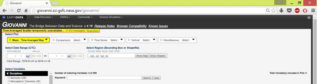
17 GIOVANNI
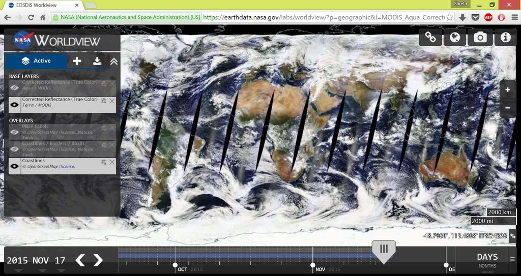
18 WORLDVIEW

19 ECHO REVERB

20 2015 Nov 01 World View Smoke Plume Himalayas Desert Coastline Vegetation Clouds Sun Glint Swath
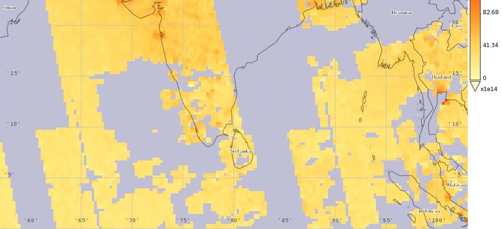
21 1-10 April 1-10 June 1-10 August 2015 Asian Haze August 1-10 September September
 -NO X -SO X - Particulate Matter")
22 Criteria Pollutants Some of the regulated pollutants in HKH. - ground level Ozone (O 3 ) -NO X -SO X - Particulate Matter (PM)

23 Overview of Polar orbiting US satellites Landsat-1 joint program of Nasa and USGS provides the longest continuous space-based record. Launched in July, Provides information on environmental pollution and meteorology. Sounce:
.")
24 Continued.. Advanced Very High Resolution Radiometer (AVHRR) - radiationdetection imager that can be used for remotely determining cloud cover and the surface temperature. First applications of satellite remote sensing of aerosol Launched in October 1978, carried on TIROS (Television Infrared Observation Satellite). Latest Version AVHRR/3, first carried on NOAA-15 launched in May Source:
25 Continued.. GOES (Geostationary Operational Environmental Satellite). Launched and developed by NASA, but turned over to NOAA for day-to-day administration. GOES-4 launched in Sep, 1980 made first vertical temp and moisture measurements. First satellite to carry Visible Infrared Spin Scan Radiometer (VISSR) atmospheric Sounder (VAS). From these cross sections, the altitudes and temperatures of clouds were determined and a 3D picture of their distribution was drawn. Frame-to-frame movement of selected clouds at different altitudes and to obtain their wind direction and speed to understand atmospheric circulation patterns. Sources:
26 Continued.. TOMS (Total Ozone Mapping Spectrometer) represent the primary long-term, continuous record of global and regional trends in total ozone over the past 25 years. Measures - tropospheric aerosols, volcanic SO2. 4 TOMS successfully launched Nimbus- 7(Nov May 1993), Meteor-3 (Aug Dec. 1994), Earth Probe (July current), and ADEOS (Sep June 1997) satellites. Source:
27 Continued.. A-Train Satellite (Afternoon Satellite) Satellite constellation of six Earth observation satellite in sun synchronous orbit ~ 705 km above the Earth. Crosses equator each day/night at around 1:30 pm/am solar time. Spaced few minutes apart from each other, so their collective observations may be used to build high-definition 3D images of earth s atmosphere and surface.

28 Continued.. Source:
29 Satellites for Atmosphere Chemistry Atmosphere AQUA (AIRS, AMSR-E, AMSU-A, CERES, HSB, MODIS) AURA (HIRDLS, MLS, OMI, TES) CALIPSO (CALIOP, IIR, WFC) TERRA (MOPITT, MODIS, MISR) TRMM (Tropical Rainfall Measuring Mission) UARS (Upper Atmosphere Radiation Satellite) GCOM-W1 (AMSR2) - Japan ERS -2 (GOME-1) ESA Meteosat (EUMETSAT) Kalpanasat (ISRO) Insat (ISRO) Etc.
 daily 1 deg.")
![[AIRS AIRX3STD v006] mol/cm2 over 2015-11-05, Region 57E, 0N, 103E, 45N Time Averaged](/docs-images/79/80329856/images/30-2.jpg "Map of Carbon Monoxide Total Column [AIRS AIRX3STD v006] mol/cm2 over 2015-11-06,")
30 Commonly regulated pollutants: CO Time Averaged Map of Carbon Monoxide Total Column (Daytime/Ascending) daily 1 deg. [AIRS AIRX3STD v006] mol/cm2 over , Region 57E, 0N, 103E, 45N Time Averaged Map of Carbon Monoxide Total Column (Daytime/Ascending) daily 1 deg. [AIRS AIRX3STD v006] mol/cm2 over , Region 57E, 0N, 103E, 45N


![AIRX3STD v006] DU on 2015-08-31.](/docs-images/79/80329856/images/31-4.jpg "region 57E, 0N, 103E, 45N")
31 Commonly regulated pollutants: O 3 Time Averaged map of Ozone Total Column (Daytime/Ascending) daily 1 deg. [AIRS AIRX3STD v006] DU over region 57E, 0N, 103E, 45N Time Averaged map of Ozone Total Column (Daytime/Ascending) daily 1 deg. [AIRS AIRX3STD v006] DU on region 57E, 0N, 103E, 45N


32 Commonly regulated pollutants: NO 2 Time Averaged Map of NO 2 Total Column (30 % Cloud Screened) daily 0.25 deg. [OMI OMNO2d v003] 1/cm2 over , Region 57E, 0N, 103E, 45N Time Averaged Map of NO 2 Total Column (30 % Cloud Screened) daily 0.25 deg. [OMI OMNO2d v003] 1/cm2 over , Region 57E, 0N, 103E, 45N
 OMSO2e v003 daily 0.25 deg.")
![[OMI OMSO2e v003] DU over 2015-10-01 2015-10-31, region 57E, 0N, 103E, 45N Time Averaged map](/docs-images/79/80329856/images/33-2.jpg "of SO2 Column Amount (Planetary [OMI OMSO2e v003] DU over 2015-11-01 2015-11-02, region 57E,")
33 Commonly regulated pollutants: SO 2 Time Averaged map of SO2 Column Amount (Planetary Boundary Layer) OMSO2e v003 daily 0.25 deg. [OMI OMSO2e v003] DU over , region 57E, 0N, 103E, 45N Time Averaged map of SO2 Column Amount (Planetary Boundary Layer) OMSO2e v003 daily 0.25 deg. [OMI OMSO2e v003] DU over , region 57E, 0N, 103E, 45N
 accessed on 18 th Nov. Source: https://firms.modaps.eosdis.nasa.")
34 MODIS active Fire Data Past 24 Hours fire data for ( to ) accessed on 18 th Nov. Source:
35
Interpretation of Polar-orbiting Satellite Observations. Atmospheric Instrumentation
 Interpretation of Polar-orbiting Satellite Observations Outline Polar-Orbiting Observations: Review of Polar-Orbiting Satellite Systems Overview of Currently Active Satellites / Sensors Overview of Sensor
History of Aerosol Remote Sensing. Mark Smithgall Maria Zatko 597K Spring 2009
 History of Aerosol Remote Sensing Mark Smithgall Maria Zatko 597K Spring 2009 Aerosol Sources Anthropogenic Biological decomposition from fertilizer and sewage treatment (ex. ammonium) Combustion of fossil
3D data in climatology
 GIS Laboratory, Institute of Geography and Spatial Management, Jagiellonian University 1 3D applications There are at least three distinct fields of Earth sciences, were 3D data play an important (or fundamental)
Satellite observation of atmospheric dust
 Satellite observation of atmospheric dust Taichu Y. Tanaka Meteorological Research Institute, Japan Meteorological Agency 11 April 2017, SDS WAS: Dust observation and modeling @WMO, Geneva Dust observations
Analyzing and Visualizing Precipitation and Soil Moisture in ArcGIS
 Analyzing and Visualizing Precipitation and Soil Moisture in ArcGIS Wenli Yang, Pham Long, Peisheng Zhao, Steve Kempler, and Jennifer Wei * NASA Goddard Earth Science Data and Information Services Center
TIROS-1. 1) National Aeronautics and Space Administration 2) National Oceanic and Atmospheric Administration
 National Aeronautics and Space Administration 2) National Oceanic and Atmospheric Administration") NOAA TIROS-1 NASA 1) National Aeronautics and Space Administration 2) National Oceanic and Atmospheric Administration Sputnik Sputlink Aerobee Aerobee TIROS-1 TIROS-1 1) Spiral swirl SeaWIFS Orb View2
NOAA TIROS-1 NASA 1) National Aeronautics and Space Administration 2) National Oceanic and Atmospheric Administration Sputnik Sputlink Aerobee Aerobee TIROS-1 TIROS-1 1) Spiral swirl SeaWIFS Orb View2
The CEOS Atmospheric Composition Constellation (ACC) An Example of an Integrated Earth Observing System for GEOSS
 An Example of an Integrated Earth Observing System for GEOSS") The CEOS Atmospheric Composition Constellation (ACC) An Example of an Integrated Earth Observing System for GEOSS Presentation Authors: E. Hilsenrath NASA, C. Zehner ESA, J. Langen ESA, J. Fishman NASA
The CEOS Atmospheric Composition Constellation (ACC) An Example of an Integrated Earth Observing System for GEOSS Presentation Authors: E. Hilsenrath NASA, C. Zehner ESA, J. Langen ESA, J. Fishman NASA
Joint Polar Satellite System. 3 rd Post-EPS User Consultation Workshop Mike Haas
 3 rd Post-EPS User Consultation Workshop Mike Haas Overview Introduction - Policy Drivers - Management System Description - Space Segment - Ground Segment Partnerships Status Benefits 2 Introduction (Policy
Back to basics: From Sputnik to Envisat, and beyond: The use of satellite measurements in weather forecasting and research: Part 1 A history
 Back to basics: From Sputnik to Envisat, and beyond: The use of satellite measurements in weather forecasting and research: Part 1 A history Roger Brugge 1 and Matthew Stuttard 2 1 NERC Data Assimilation
REMOTE SENSING KEY!!
 REMOTE SENSING KEY!! This is a really ugly cover page I m sorry. Name Key. Score / 100 Directions: You have 50 minutes to take this test. You may use a cheatsheet (2 pages), a non-graphing calculator,
GEOSC/METEO 597K Kevin Bowley Kaitlin Walsh
 GEOSC/METEO 597K Kevin Bowley Kaitlin Walsh Timeline of Satellites ERS-1 (1991-2000) NSCAT (1996) Envisat (2002) RADARSAT (2007) Seasat (1978) TOPEX/Poseidon (1992-2005) QuikSCAT (1999) Jason-2 (2008)
Update on SCOPE-Nowcasting Pilot Project Real Time Ocean Products Suman Goyal Scientist-E
 Update on SCOPE-Nowcasting Pilot Project Real Time Ocean Products Suman Goyal Scientist-E 19-22 Nov 2013 SCOPE-Nowcasting-1 Agenda Item 5 Pilot Projects Overview Users /Clients User requirements Product
APPENDIX 2 OVERVIEW OF THE GLOBAL PRECIPITATION MEASUREMENT (GPM) AND THE TROPICAL RAINFALL MEASURING MISSION (TRMM) 2-1
 AND THE TROPICAL RAINFALL MEASURING MISSION (TRMM) 2-1") APPENDIX 2 OVERVIEW OF THE GLOBAL PRECIPITATION MEASUREMENT (GPM) AND THE TROPICAL RAINFALL MEASURING MISSION (TRMM) 2-1 1. Introduction Precipitation is one of most important environmental parameters.
APPENDIX 2 OVERVIEW OF THE GLOBAL PRECIPITATION MEASUREMENT (GPM) AND THE TROPICAL RAINFALL MEASURING MISSION (TRMM) 2-1 1. Introduction Precipitation is one of most important environmental parameters.
Long-lead prediction of the 2015 fire and haze episode in Indonesia
 Long-lead prediction of the 2015 fire and haze episode in Indonesia Robert Field 1,2 Dilshad Shawki 3, Michael Tippett 2, Bambang Hero Saharjo 4, Israr Albar 5, Dwi Atmoko 6, Apostolos Voulgarakis 1 1.
REMOTE SENSING TEST!!
 REMOTE SENSING TEST!! This is a really ugly cover page I m sorry. Name. Score / 100 Directions: (idk if I need to put this???) You have 50 minutes to take this test. You may use a cheatsheet (2 pages),
Lecture 4b: Meteorological Satellites and Instruments. Acknowledgement: Dr. S. Kidder at Colorado State Univ.
 Lecture 4b: Meteorological Satellites and Instruments Acknowledgement: Dr. S. Kidder at Colorado State Univ. US Geostationary satellites - GOES (Geostationary Operational Environmental Satellites) US
National Aeronautics and Space Administration. Earth Day is everyday at NASA. activity booklet
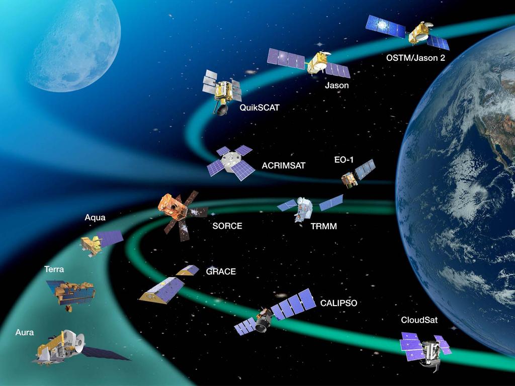
 National Aeronautics and Space Administration Earth Day is everyday at NASA activity booklet Earth Day is everyday at NASA NASA s Fleet of Earth Observing Satellites ACRIMSAT Landsat 7 Aqua SORCE Terra
GRACE Cloudsat CALIPSO Aqua. Metop TRMM TOPEX. Meteor/ SAGE GIFTS NOAA/ POES. Landsat GOES MTSAT. SeaWiFS. Aura. Terra MSG. Jason ICESat SORCE
 TRMM Metop GRACE Cloudsat CALIPSO Aqua TOPEX Meteor/ SAGE GIFTS NOAA/ POES Landsat GOES SeaWiFS MTSAT Terra Aura Jason ICESat SORCE MSG THE EARTH SYSTEM SCIENCE It is the science that studies the whole
- satellite orbits. Further Reading: Chapter 04 of the text book. Outline. - satellite sensor measurements
 (1 of 12) Further Reading: Chapter 04 of the text book Outline - satellite orbits - satellite sensor measurements - remote sensing of land, atmosphere and oceans (2 of 12) Introduction Remote Sensing:
The Probabilistic Risk Assessment of the CloudSat Profiling Radar
 The Probabilistic Risk Assessment of the CloudSat Profiling Radar Todd Paulos, Alejo Engineering, Simi Valley, CA John Klohoker,,, Pasadena, CA May 2008 What is CloudSat? Launched on April 28, 2006 with
Welcome and Introduction
 Welcome and Introduction Riko Oki Earth Observation Research Center (EORC) Japan Aerospace Exploration Agency (JAXA) 7th Workshop of International Precipitation Working Group 17 November 2014 Tsukuba International
GSICS UV Sub-Group Activities
 GSICS UV Sub-Group Activities Rosemary Munro with contributions from NOAA, NASA and GRWG UV Subgroup Participants, in particular L. Flynn 1 CEOS Atmospheric Composition Virtual Constellation Meeting (AC-VC)
Japanese Programs on Space and Water Applications
 Japanese Programs on Space and Water Applications Tamotsu IGARASHI Remote Sensing Technology Center of Japan June 2006 COPUOS 2006 Vienna International Centre Water-related hazards/disasters may occur
Remote Sensing in Meteorology: Satellites and Radar. AT 351 Lab 10 April 2, Remote Sensing
 Remote Sensing in Meteorology: Satellites and Radar AT 351 Lab 10 April 2, 2008 Remote Sensing Remote sensing is gathering information about something without being in physical contact with it typically
Non-meteorological Applications for Next Generation Geostationary Meteorological Satellites
 Non-meteorological Applications for Next Generation Geostationary Meteorological Satellites Toshiyuki KURINO Satellite Program Division Japan Meteorological Agency Topics Advanced GEO for Earth Observation
MODULE 2 LECTURE NOTES 1 SATELLITES AND ORBITS
 MODULE 2 LECTURE NOTES 1 SATELLITES AND ORBITS 1. Introduction When a satellite is launched into the space, it moves in a well defined path around the Earth, which is called the orbit of the satellite.
Disaster Mitigation Competence Centre Project Meeting Coordinator: Simon Lin
 Disaster Mitigation Competence Centre Project Meeting Coordinator: Simon Lin April 26, 2018 Agenda Introduction (Simon Lin) From Previous Meeting on March 17, 2015 (Eric Yen) Progress Report (Eric Yen)
Remote Sensing I: Basics
 Remote Sensing I: Basics Kelly M. Brunt Earth System Science Interdisciplinary Center, University of Maryland Cryospheric Science Laboratory, Goddard Space Flight Center kelly.m.brunt@nasa.gov (Based on
Future NASA Atmospheric Missions: Adding to the A-Train Calipso OCO NPP CloudSat Glory
 Future NASA Atmospheric Missions: Adding to the A-Train James Gleason NASA Goddard Space Flight Center, Mail Code 613.3, Greenbelt, MD 20771, United States Abstract Following on the successful launch of
GEMS. Nimbus 4, Nimbus7, NOAA-9, NOAA11, NOAA16, NOAA17
 GEMS (Geostationary Environment Monitoring Spectrometer) SBUV,BUV TOMS (50x50km 2 ) Nimbus7, METEOR-3, ADEOS, Earth-probe GOME1/2 (40x40km 2 ) ERS-2 SCIAMACHY (30x60km 2 ) OMI (13x24km2) OMPS (50x50km
Lecture 4: Meteorological Satellites and Instruments. Acknowledgement: Dr. S. Kidder at Colorado State Univ.
 Lecture 4: Meteorological Satellites and Instruments Acknowledgement: Dr. S. Kidder at Colorado State Univ. Homework for the Spring Break: get some tangible, preliminary results for your final project.
International Cooperation in Operational Environmental Satellites: The U.S. Experience
 Committee on the Peaceful Uses of Outer Space Science and Technology Sub committee Forty seventh session February 17, 2010 Vienna, Austria International Cooperation in Operational Environmental Satellites:
JAXA Remote Sensing Satellite Missions Utilization for Earth and Environment Observation
 JAXA Remote Sensing Satellite Missions Utilization for Earth and Environment Observation 27 th June 2013 Toshiyoshi Kimura EORC/JAXA Inventory, Modeling and Climate Impacts of Greenhouse Gas emissions
Impact of NASA EOS data on the scientific literature: 16 years of published research results from Terra, Aqua, Aura, and Aquarius
 Impact of NASA EOS data on the scientific literature: 16 years of published research results from Terra, Aqua, Aura, and Aquarius Gene R. Major NASA Goddard Library Nebulous Connections April 4, 2017 RESACs/RA
Vertical distribution of dust aerosols from 5 years of CALIPSO observations
 Vertical distribution of dust aerosols from 5 years of CALIPSO observations, Alain Chédin, Sophie Peyridieu Laboratoire de Météorologie Dynamique CNRS/IPSL, Ecole Polytechnique christoforos.tsamalis@lmd.polytechnique.fr
Satellite Constraints on Arctic-region Airborne Particles Ralph Kahn NASA Goddard Space Flight Center
 Satellite Constraints on Arctic-region Airborne Particles Ralph Kahn NASA Goddard Space Flight Center Sea of Okhotsk, MODIS image Feb. 6, 2007, NASA Earth Observatory Arctic Aerosol Remote Sensing Overview
Country Report - Singapore
 Country Report - Singapore The 5th Meeting of the Coordinating Group Vladivostok city, Russky Island, Russia Far Eastern Federal University of the RA II WIGOS Satellite Project 21 October 2017 Outline
Updates on Chinese Meteorological Satellite Programs
 6 th Asia/Oceania Meteorological Satellite Users Conference Updates on Chinese Meteorological Satellite Programs Caiying Wei Deputy director-general of NSMC National Satellite Meteorological Center (NSMC)
Radio Frequency Earth Science
 Radio Frequency Earth Science Overview for Committee On Radio Frequency (CORF) National Academy of Science National Research Council April 27, 2005 Bill.Watson@NASA.Gov Program Executive for Ground Networks
Chapter 4 Nadir looking UV measurement. Part-I: Theory and algorithm
 Chapter 4 Nadir looking UV measurement. Part-I: Theory and algorithm -Aerosol and tropospheric ozone retrieval method using continuous UV spectra- Atmospheric composition measurements from satellites are
ATMOSPHERIC OZONE REMOTE SENSING AND THE VALORIZATION OF THE WEB-SITES CONTAINING SUCH SPECIFIC INFORMATION
 VASILE LOGHIN 357 ATMOSPHERIC OZONE REMOTE SENSING AND THE VALORIZATION OF THE WEB-SITES CONTAINING SUCH SPECIFIC INFORMATION Keywords: ozone, UV radiation, remote sensing, SCIAMACHY, website, databases
JPSS GEONETCAST REQUIREMENTS DISCUSSION
 Joint Polar Satellite System (JPSS) JPSS GEONETCAST REQUIREMENTS DISCUSSION Mitch Goldberg Program Scientist Joint Polar Satellite System National Environmental Satellite, Data, and Information Service
GMES: calibration of remote sensing datasets
 GMES: calibration of remote sensing datasets Jeremy Morley Dept. Geomatic Engineering jmorley@ge.ucl.ac.uk December 2006 Outline Role of calibration & validation in remote sensing Types of calibration
A two-season impact study of the Navy s WindSat surface wind retrievals in the NCEP global data assimilation system
 A two-season impact study of the Navy s WindSat surface wind retrievals in the NCEP global data assimilation system Li Bi James Jung John Le Marshall 16 April 2008 Outline WindSat overview and working
Title: The Impact of Convection on the Transport and Redistribution of Dust Aerosols
 Authors: Kathryn Sauter, Tristan L'Ecuyer Title: The Impact of Convection on the Transport and Redistribution of Dust Aerosols Type of Presentation: Oral Short Abstract: The distribution of mineral dust
Comparison of black carbon and ozone variability at the Kathmandu hot spot and at the southern Himalayas
 Comparison of black carbon and ozone variability at the Kathmandu hot spot and at the southern Himalayas Davide Putero, Angela Marinoni, Paolo Bonasoni, Francescopiero Calzolari, and Paolo Cristofanelli
NASA WGCV37 Update. K. Thome Based on charts from M. Freilich and H. Maring Earth Science Division, Science Mission Directorate February 2014
 NASA WGCV37 Update K. Thome Based on charts from M. Freilich and H. Maring Earth Science Division, Science Mission Directorate February 2014 NASA On-Orbit Operating Flight Missions Missions Partnerships
Appendix B. A proposition for updating the environmental standards using real Earth Albedo and Earth IR Flux for Spacecraft Thermal Analysis
 19 Appendix B A proposition for updating the environmental standards using real Earth Albedo and Earth IR Romain Peyrou-Lauga (ESA/ESTEC, The Netherlands) 31 st European Space Thermal Analysis Workshop
GEOG Lecture 8. Orbits, scale and trade-offs
 Environmental Remote Sensing GEOG 2021 Lecture 8 Orbits, scale and trade-offs Orbits revisit Orbits geostationary (36 000 km altitude) polar orbiting (200-1000 km altitude) Orbits revisit Orbits geostationary
Instrumentation planned for MetOp-SG
 Instrumentation planned for MetOp-SG Bill Bell Satellite Radiance Assimilation Group Met Office Crown copyright Met Office Outline Background - the MetOp-SG programme The MetOp-SG instruments Summary Acknowledgements:
Fifty Years of Operational Environmental Satellites: The U.S. Experience
 United Nations Committee on the Peaceful Uses of Outer Space Vienna, Austria June 15, 2010 Fifty Years of Operational Environmental Satellites: The U.S. Experience Mr. Charles Baker Deputy Assistant Administrator
). It is a gas produced naturally in the stratosphere where it strongly absorbs incoming
. It is a gas produced naturally in the stratosphere where it strongly absorbs incoming") Page 1 of 6 What Determines How Much Ultraviolet Radiation Reaches the Earth s Surface? The amount of UV radiation reaching the Earth s surface varies widely around the globe and through time. Several
Page 1 of 6 What Determines How Much Ultraviolet Radiation Reaches the Earth s Surface? The amount of UV radiation reaching the Earth s surface varies widely around the globe and through time. Several
Module 1, Investigation 2: Log Sensing volcanic effects from space
 Module 1, Investigation 2: Log Sensing volcanic effects from space Background Volcanoes are extremely disruptive and destructive to the environment and to the people who live nearby. They may disrupt the
McIDAS support of Suomi-NPP /JPSS and GOES-R L2
 McIDAS support of Suomi-NPP /JPSS and GOES-R L2 William Straka III 1 Tommy Jasmin 1, Bob Carp 1 1 Cooperative Institute for Meteorological Satellite Studies, Space Science and Engineering Center, University
Amita Mehta and Ana Prados
 Building Capacity in Utilizing NASA Remote Sensing Observations in SWAT for Water Resources and Agricultural Management Applications Amita Mehta and Ana Prados NASA - University of Maryland Baltimore County
Global observations from CALIPSO
 Global observations from CALIPSO Dave Winker, Chip Trepte, and the CALIPSO team NRL, Monterey, 27-29 April 2010 Mission Overview Features: Two-wavelength backscatter lidar First spaceborne polarization
EUMETSAT PLANS. K. Dieter Klaes EUMETSAT Darmstadt, Germany
 EUMETSAT PLANS K. Dieter Klaes EUMETSAT Darmstadt, Germany 1. INTRODUCTION The European Organisation for the Exploitation of Meteorological Satellites (EUMETSAT), contributes to the World Weather Watch
Satellite Data For Applications: Aviation/Volcanic Ash. Richard Eckman NASA 27 May 2013
 Satellite Data For Applications: Aviation/Volcanic Ash Richard Eckman NASA 27 May 2013 Background Following the unprecedented disruption to aviation by the recent eruptions of Eyjafjallajökull and Grímsvötn
Overview and Access to GPCP, TRMM, and GPM Precipitation Data Products
 National Aeronautics and Space Administration ARSET Applied Remote Sensing Training http://arset.gsfc.nasa.gov @NASAARSET Overview and Access to GPCP, TRMM, and GPM Precipitation Data Products www.nasa.gov
CEOS Overview and JAXA Plans for Water Cycle Observation
 CEOS Overview and JAXA Plans for Water Cycle Observation Asian Water Cycle Symposium November 2-4, 2005 Tokyo, Japan Chu Ishida Japan Aerospace Exploration Agency (JAXA) Contents 1. CEOS overview 2. CEOS
REVISION OF THE STATEMENT OF GUIDANCE FOR GLOBAL NUMERICAL WEATHER PREDICTION. (Submitted by Dr. J. Eyre)
") WORLD METEOROLOGICAL ORGANIZATION Distr.: RESTRICTED CBS/OPAG-IOS (ODRRGOS-5)/Doc.5, Add.5 (11.VI.2002) COMMISSION FOR BASIC SYSTEMS OPEN PROGRAMME AREA GROUP ON INTEGRATED OBSERVING SYSTEMS ITEM: 4 EXPERT
WORLD METEOROLOGICAL ORGANIZATION Distr.: RESTRICTED CBS/OPAG-IOS (ODRRGOS-5)/Doc.5, Add.5 (11.VI.2002) COMMISSION FOR BASIC SYSTEMS OPEN PROGRAMME AREA GROUP ON INTEGRATED OBSERVING SYSTEMS ITEM: 4 EXPERT
NASA Earth Science Data Systems Program. Martha Maiden Program Executive, Earth Science Data Systems Earth Science Subcommittee November 28, 2012
 NASA Earth Science Data Systems Program Martha Maiden Program Executive, Earth Science Data Systems Earth Science Subcommittee November 28, 2012 NASA s Earth Observing System Data and Information System
IDEA. from research to routine
 IDEA. from research to routine A collaboration between NASA, EPA, NOAA and CIMSS Cooperative Institute for Meteorological Satellite Studies Infusing satellite Data in Environmental Applications (IDEA)
COUNTRY REPORT INDONESIA
 COUNTRY REPORT INDONESIA Badan Meteorologi Klimatologi dan Geofisika (BMKG) Agency For Meteorology, Climatology, and Geophysics Republic of Indonesia DKI Jakarta, Indonesia Tel. (021) 4246321 Email: pcs@bmkg.go.id
Weather and Climate: Satellite Meteorology
 LIVE INTERACTIVE LEARNING @ YOUR DESKTOP Weather and Climate: Satellite Meteorology Presented by: Rudo Kashiri April 4, 2013 6:30 p.m. 8:00 p.m. Eastern time 1 2 http://learningcenter.nsta.org NSTA Learning
JAXA s Contributions to the Climate Change Monitoring
 0 JAXA s Contributions to the Climate Change Monitoring June 7, 2011 Takao Akutsu Planning Manager Japan Aerospace Exploration Agency (JAXA) Japanese Main Activities of Earth Observation 1 GEOSS 10 years
Arctic Weather Every 10 Minutes: Design & Operation of ABI for PCW
 Arctic Weather Every 10 Minutes: Design and Operation of ABI for PCW Dr. Paul C. Griffith and Sue Wirth 31st Space Symposium, Technical Track, Colorado Springs, Colorado This document is not subject to
P6.13 GLOBAL AND MONTHLY DIURNAL PRECIPITATION STATISTICS BASED ON PASSIVE MICROWAVE OBSERVATIONS FROM AMSU
 P6.13 GLOBAL AND MONTHLY DIURNAL PRECIPITATION STATISTICS BASED ON PASSIVE MICROWAVE OBSERVATIONS FROM AMSU Frederick W. Chen*, David H. Staelin, and Chinnawat Surussavadee Massachusetts Institute of Technology,
Some NOAA Products that Address PSTG Satellite Observing Requirements. Jeff Key NOAA/NESDIS Madison, Wisconsin USA
 Some NOAA Products that Address PSTG Satellite Observing Requirements Jeff Key NOAA/NESDIS Madison, Wisconsin USA WMO Polar Space Task Group, 4 th meeting, Greenbelt, 30 September 2014 Relevant Missions
T. Dale Bess 1 and Takmeng Wong Atmospheric Sciences Division Langley Research Center, NASA Hampton, VA G. Louis Smith
 P1.7 ONE YEAR OF DAILY AVERAGED LONGWAVE RADIATION MEASUREMENTS FOR ENVIRONMENTAL AND CLIMATE CHANGE STUDIES T. Dale Bess 1 and Takmeng Wong Atmospheric Sciences Division Langley Research Center, NASA
10 emergency observation requests were successfully processed during the period
 ISRO s Inputs for the Sentinel Asia DPN and JPT meeting being held during 13-16, 16, November 2012 November 2012 Sentinel Asia Activity Spectrum - A dedicated Sentinel Asia server established at NRSC,
Current capabilities and limitations of satellite monitoring and modeling forecasting of volcanic clouds: and example of Eyjafjallaj
 Current capabilities and limitations of satellite monitoring and modeling forecasting of volcanic clouds: and example of Eyjafjallaj fjallajökull eruption (pronounced EYE-a-fyat fyat-la-jo-kotl) N. Krotkov
PHEOS - Weather, Climate, Air Quality
 Aerosol & cloud remote sensing over the Arctic : perspectives for the PHEMOS and meteorological imager payloads on the PCW mission Norm O Neill, Auromeet Saha, U. de Sherbrooke Chris E. Sioris, Jack McConnell,
CGMS Baseline. Sustained contributions to the Global Observing System. Endorsed by CGMS-46 in Bengaluru, June 2018
 CGMS Baseline Sustained contributions to the Global Observing System Best Practices for Achieving User Readiness for New Meteorological Satellites Endorsed by CGMS-46 in Bengaluru, June 2018 CGMS/DOC/18/1028862,
Global Flood Alert System based on satellite derived rainfall data -Targeting the era of Global Precipitation Measurement (GPM)-
-") Global Flood Alert System based on satellite derived rainfall data -Targeting the era of Global Precipitation Measurement (GPM)- Riko Oki, Misako Kachi (JAXA/EORC) Kazuhiko Fukami (PWRI) and Kazuo Umeda
Global Flood Alert System based on satellite derived rainfall data -Targeting the era of Global Precipitation Measurement (GPM)- Riko Oki, Misako Kachi (JAXA/EORC) Kazuhiko Fukami (PWRI) and Kazuo Umeda
Current Status of the Stratospheric Ozone Layer From: UNEP Environmental Effects of Ozone Depletion and Its Interaction with Climate Change
 Goals Produce a data product that allows users to acquire time series of the distribution of UV-B radiation across the continental USA, based upon measurements from the UVMRP. Provide data in a format
Central Ohio Air Quality End of Season Report. 111 Liberty Street, Suite 100 Columbus, OH Mid-Ohio Regional Planning Commission
 217 218 Central Ohio Air Quality End of Season Report 111 Liberty Street, Suite 1 9189-2834 1 Highest AQI Days 122 Nov. 217 Oct. 218 July 13 Columbus- Maple Canyon Dr. 11 July 14 London 11 May 25 New Albany
EPS-SG Candidate Observation Missions
 EPS-SG Candidate Observation Missions 3 rd Post-EPS User Consultation Workshop Peter Schlüssel Slide: 1 EPS-SG benefits to activities of NMSs Main Payload High-Resolution Infrared Sounding Microwave Sounding
Satellite-based Lake Surface Temperature (LST) Homa Kheyrollah Pour Claude Duguay
 Homa Kheyrollah Pour Claude Duguay") Satellite-based Lake Surface Temperature (LST) Homa Kheyrollah Pour Claude Duguay Lakes in NWP models Interaction of the atmosphere and underlying layer is the most important issue in climate modeling
Satellite-based Lake Surface Temperature (LST) Homa Kheyrollah Pour Claude Duguay Lakes in NWP models Interaction of the atmosphere and underlying layer is the most important issue in climate modeling
A new perspective on aerosol direct radiative effects in South Atlantic and Southern Africa
 A new perspective on aerosol direct radiative effects in South Atlantic and Southern Africa Ian Chang and Sundar A. Christopher Department of Atmospheric Science University of Alabama in Huntsville, U.S.A.
Global Satellite Products & Services for Agricultural and Vegetation Health
 Global Satellite Products & Services for Agricultural and Vegetation Health Presented at the WMO Expert Meeting on National Early Warning System for Agricultural Weather Management George Mason University
Moderate Resolution Imaging Spectroradiometer (MODIS) Products and Potential Applications For Environmental and Climatic Monitoring in China
 Products and Potential Applications For Environmental and Climatic Monitoring in China") Moderate Resolution Imaging Spectroradiometer (MODIS) Products and Potential Applications For Environmental and Climatic Monitoring in China Jianhe (John) Qu Center for Earth Observing and Space Research
Moderate Resolution Imaging Spectroradiometer (MODIS) Products and Potential Applications For Environmental and Climatic Monitoring in China Jianhe (John) Qu Center for Earth Observing and Space Research
Influence of Clouds and Aerosols on the Earth s Radiation Budget Using Clouds and the Earth s Radiant Energy System (CERES) Measurements
 Measurements") Influence of Clouds and Aerosols on the Earth s Radiation Budget Using Clouds and the Earth s Radiant Energy System (CERES) Measurements Norman G. Loeb Hampton University/NASA Langley Research Center Bruce
Influence of Clouds and Aerosols on the Earth s Radiation Budget Using Clouds and the Earth s Radiant Energy System (CERES) Measurements Norman G. Loeb Hampton University/NASA Langley Research Center Bruce
The use of Direct Broadcast Processing System in Poland
 The use of Direct Broadcast Processing System in Poland B.Łapeta, P.Struzik Satellite Remote Sensing Department, Institute of Meteortology and Water Management National Reasearch Institute About IMWM-NRI
School on Modelling Tools and Capacity Building in Climate and Public Health April Rainfall Estimation
 2453-6 School on Modelling Tools and Capacity Building in Climate and Public Health 15-26 April 2013 Rainfall Estimation CECCATO Pietro International Research Institute for Climate and Society, IRI The
JAXA Earth Observation Satellites and the Validation
 JAXA Earth Observation Satellites and the Validation Keiji Imaoka + many colleagues Earth Observation Research Center (EORC) Japan Aerospace Exploration Agency (JAXA) March 9, 2012 4 th GRUAN ICM Meeting
Chart 1 Changing the Perspective: Atmospheric Research on the ISS Prof. Dr. Hansjörg Dittus German Aerospace Center (DLR)
") www.dlr.de Chart 1 Changing the Perspective: Atmospheric Research on the ISS Prof. Dr. Hansjörg Dittus German Aerospace Center (DLR) www.dlr.de Chart 2 DLR German Aerospace Center Research Institution
www.dlr.de Chart 1 Changing the Perspective: Atmospheric Research on the ISS Prof. Dr. Hansjörg Dittus German Aerospace Center (DLR) www.dlr.de Chart 2 DLR German Aerospace Center Research Institution
Interannual variation of MODIS NDVI in Lake Taihu and its relation to climate in submerged macrophyte region
 Yale-NUIST Center on Atmospheric Environment Interannual variation of MODIS NDVI in Lake Taihu and its relation to climate in submerged macrophyte region ZhangZhen 2015.07.10 1 Outline Introduction Data
Launched on May 4, K. Hokusai
 CITES-2009 CITES-2009 CONFERENCE CONFERENCE KRASNOYARSK, KRASNOYARSK, Russia Russia OBSERVING THE EARTH FROM SPACE AS AN INTEGRATED SYSTEM: THE USA/F* A-TRAIN CONCEPT G. BEGNI, D. RENAUT (CNES CNES), D.
Projects in the Remote Sensing of Aerosols with focus on Air Quality
 Projects in the Remote Sensing of Aerosols with focus on Air Quality Faculty Leads Barry Gross (Satellite Remote Sensing), Fred Moshary (Lidar) Direct Supervision Post-Doc Yonghua Wu (Lidar) PhD Student
Weather Satellite Data Applications for Monitoring and Warning Hazard at BMKG
 The 5th Meeting of the Coordinating Group of the RA II WIGOS Satellite Project 21 October 2017, Vladivostok city, Russky Island, Russia Far Eastern Federal University Weather Satellite Data Applications
Climate Variability in South Asia
 Climate Variability in South Asia V. Niranjan, M. Dinesh Kumar, and Nitin Bassi Institute for Resource Analysis and Policy Contents Introduction Rainfall variability in South Asia Temporal variability
Challenges for the operational assimilation of satellite image data in agrometeorological models
 Challenges for the operational assimilation of satellite image data in agrometeorological models Mark Danson Centre for Environmental Systems Research, University of Salford, UK 0 Objectives The main objective
NOAA Report. Hal Bloom Mitch Goldberg NOAA/NESDIS
 NOAA Report Hal Bloom Mitch Goldberg NOAA/NESDIS Summary of Major Events at NESDIS (of interest to ITSC) NOAA/NASA addressing NPOESS Climate Sensors Letter of agreement signed with JAXA on GCOM interagency
New NASA Ocean Observations and Coastal Applications
 New NASA Ocean Observations and Coastal Applications Duane Armstrong Chief, Applied Science & Technology Project Office August 20, 2014 1 Outline NASA s new Earth Science Ocean Science Missions for 2014
The Copernicus Sentinel-5 Mission: Daily Global Data for Air Quality, Climate and Stratospheric Ozone Applications
 SENTINEL-5 The Copernicus Sentinel-5 Mission: Daily Global Data for Air Quality, Climate and Stratospheric Ozone Applications Yasjka Meijer RHEA for ESA, Noordwijk, NL 15/04/2016 Co-Authors: Jörg Langen,
Lecture 1d: Satellite Orbits
 Lecture 1d: Satellite Orbits Outline 1. Newton s Laws of Motion 2. Newton s Law of Universal Gravitation 3. Kepler s Laws 4. Putting Newton and Kepler s Laws together and applying them to the Earth-satellite
Lectures 7 and 8: 14, 16 Oct Sea Surface Temperature
 Lectures 7 and 8: 14, 16 Oct 2008 Sea Surface Temperature References: Martin, S., 2004, An Introduction to Ocean Remote Sensing, Cambridge University Press, 454 pp. Chapter 7. Robinson, I. S., 2004, Measuring
Land Surface Temperature Measurements From the Split Window Channels of the NOAA 7 Advanced Very High Resolution Radiometer John C.
 Land Surface Temperature Measurements From the Split Window Channels of the NOAA 7 Advanced Very High Resolution Radiometer John C. Price Published in the Journal of Geophysical Research, 1984 Presented
SPACE TECHNOLOGY INSTITUTE, VNREDSat-1 and DATA PROVIDER NODE (DPN) REPORT
 REPORT") 4th Joint Project Team Meeting for Sentinel Asia STEP3 (JPTM2017) 8-9 March 2017 SPACE TECHNOLOGY INSTITUTE, VNREDSat-1 and DATA PROVIDER NODE (DPN) REPORT www.sti.vast.ac.vn CONTENT 1. Overview of Space
4th Joint Project Team Meeting for Sentinel Asia STEP3 (JPTM2017) 8-9 March 2017 SPACE TECHNOLOGY INSTITUTE, VNREDSat-1 and DATA PROVIDER NODE (DPN) REPORT www.sti.vast.ac.vn CONTENT 1. Overview of Space