JAXA Earth Observation Satellites and the Validation
|
|
|
- Shanon Parrish
- 5 years ago
- Views:
Transcription
1 JAXA Earth Observation Satellites and the Validation Keiji Imaoka + many colleagues Earth Observation Research Center (EORC) Japan Aerospace Exploration Agency (JAXA) March 9, th GRUAN ICM Meeting
2 Ground-based and Satellite Measurements Satellite community needs in-situ data - Construction of atmosphere models for forward radiative transfer calculation and retrieval scheme. - Validation of satellite retrievals and refinement of retrieval algorithms (various time scales). - Synergistic use of in-situ and satellite data to understand various phenomena. Typical characteristics - In-situ data - Point measurement with vertical information, accurate, frequent, etc. - Satellite data - Wide swath (narrow swath) observation with column (vertical profile), intermittent, sometimes have calibration issues (sometimes...). 2
3 Satellite Validation Activities Validation by utilizing the existing observation networks: - Radiosondes and GPS networks, SST and sea surface wind speed from various buoy system, Ground-based precipitation radar networks, Snow depth and other surface measurements by meteorological agencies, etc. Specific field campaigns/monitorings - Specific field campaigns/monitorings for geophysical parameters for which continuous and global observations are not available. 3


4 Current and Future JAXA EO Missions Aqua/AMSR AMSR-E GOSAT GCOM-C Carbon cycle and land cover Spatial distribution of cloud and aerosols Water cycle Water vapor Atmosphere Water cycle GCOM-W Radiative forcing EarthCARE/CPR CPR 3D structure of cloud and aerosols TRMM/PR ALOS-2,3 Green house gases High resolution mapping Carbon cycle Vegetation production Land sink-source Green house gases discharge Land cover Soil moisture Snow Ice Aerosol Carbon cycle sink-source Ocean primary production Coastal environment Water cycle Cloud Precipitation Sea-surface wind Sea-surface temperature Ocean Deep ocean circulation PH, nutrients, dissolved CO 2 GPM/DPR 3D structure of precipitation & High-frequent precipitation map Other variables: Ozone Sea level Salinity Sea state GCOM GCOM-C: Long-term observation of the horizontal distribution of aerosol, cloud, and ecosystem CO 2 absorption and discharge GCOM GCOM-W: Long-term observation of water-cycle such as the snow/ice coverage, water vapor, and SST GOSAT GOSAT: Observation of distribution and flux of the atmospheric greenhouse gases, CO 2 and CH 4 EarthCARE/ EarthCARE/CPR CPR: Observation of vertical structure of clouds and aerosols GPM/ GPM/DPR DPR: Accurate and frequent observation of precipitation with active and passive sensors ALOS ALOS-2,3 2,3: Fine resolution mapping by optical and SAR instruments ISS/JEM: Demonstration of new missions (e.g., SMILES, GLISM, etc.)... ISS/JEM 4
5 Tropical Rainfall Measuring Mission (TRMM) TMI TRMM Microwave Imager Orbit Altitude Inclination Non-sun-synchronous circular orbit 350 km km after Aug 2001) 35 deg LIS Lightning Imaging Sensor CERES Clouds and Earth s Radiant Energy System VIRS Visible Infrared Scanner PR Precipitation Radar Instruments Precipitation Radar (PR) TRMM Microwave Imager (TMI) Visible Infrared Scanner (VIRS) Clouds and the Earth s Radiant Energy System (CERES) Lightning Imaging Sensor (LIS) Launch 28th Nov


6 Observation of 3-dimensional Structure by TRMM PR Typhoon No.8 in 2000 PR swath 220km 6
: Aug.")


7 Global Rainfall Map in Near Real Time Typhoon MORAKOT (09W): Aug. 5 10, 2009 (Big impact in Chinese Taipei) Global rainfall map merging TRMM, Aqua/AMSR-E and other satellite information Available 4-hour after observation, hourly update 0.1-degree latitude/longitude grid 7

 channels for estimating SST and soil moisture.")
8 Advanced Microwave Scanning Radiometer for EOS (AMSR-E) Mission status - Operation was halted on October 4, 2011 due to the overrun of the antenna rotation torque, after the continuous observation over 9 years from EOS Aqua satellite. Investigations are underway. - AMSR-E data had been used in NWP and typhoon analyis in JMA. Instrument characteristics - Multi-frequency microwave radiometer with dual polarization capability (developed by JAXA). - High-spatial resolution compared to existing instruments by large size antenna. - C-band (6.9GHz) channels for estimating SST and soil moisture. - Afternoon (1:30 pm) equatorial crossing time that is currently unique for microwave radiometers. Aqua satellite Pre-launch AMSR-E in Tsukuba Space Center 8
9 Observations by AMSR-E Lowest record 9
 Soil moisture ratio of 2007 to")

10 Observations by AMSR-E December 2005 Evaporation (E) Soil moisture ratio of 2007 to 2005 Precipitation (P) E P Sea surface fresh water flux by AMSR-E Soil moisture ratio of 2010 to

11 AMSR-E Integrated Water Vapor 11
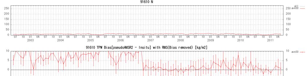
12 Radiosondes used for Validation 12
13 13
14 14

15 Radiosondes and GPS TPW comparison between AMSR-E and radiosondes GPS TPW comparison between AMSR-E and GPS GPS total precipitable water was computed and provided by Dr. Shoji of MRI. 15
16 Greenhouse Gases Observing Satellite (GOSAT) GOSAT enables global (with 56,000 points) and frequent (at every 3 days) monitoring CO2 and CH4 column density. (Launched in Jan 2009) TANSO-CAI (Cloud and Aerosol Imager) TANSO-FTS (Fourier Transform Spectrometer) Current Ground-based Observation Points (320pts) Provided by WMO WDCGG Increase of Observation Points using GOSAT (56,000pts) 16

17 GOSAT CO 2 global distributions CO2 column density decreases from May to August in the Northern Hemisphere because of photosynthesis. CO2 high density CO2 low density 2010/5 CO2 column density [ppm] 2010/8 17


18 Spectrum observed by GOSAT Source: NIES GOSAT pamphlet 18
 vs Radiosonde GOSAT vs Radiosonde Agreement within ±50% (within ±10% on average) Results provided by Dr. Ohyama of JAXA/EORC.")
19 Comparison of H 2 O profiles between GOSAT and Radiosonde Computed H 2 O concentration from radiosonde humidity profiles (Meisei RS-01G) obtained during the GOSAT validation campaign in Feb 2010, Jan-Feb 2011, and Jan Initial value (NCEP) vs Radiosonde GOSAT vs Radiosonde Agreement within ±50% (within ±10% on average) Results provided by Dr. Ohyama of JAXA/EORC. Radiosonde data were provided by Drs. Morino and Uchino of NIES. 19

20 Comparison of Ozone Profiles between GOSAT and Ozonesonde Observations Match-up condition: 100km, 6h Positive bias near-tropopause Results provided by Dr. Ohyama of JAXA/EORC. Ozonesonde data: 20

 from JEM/ISS with latitudinal")
21 SMILES on ISS/JEM: High sensitivity in detecting atmospheric limb emission in the submillimeter wave range ( GHz). Vertical profiling (~3km) from JEM/ISS with latitudinal coverage from 65N to 38S. NICT and JAXA joint activity. 21

22 Results provided by Dr. Sagawa of NICT. 22

23 Results provided by Dr. Sagawa of NICT. 23
24 Currently and Future JAXA EO Missions Aqua/AMSR AMSR-E GOSAT GCOM-C Carbon cycle and land cover Spatial distribution of cloud and aerosols Water cycle Water vapor Atmosphere Water cycle GCOM-W Radiative forcing EarthCARE/CPR CPR 3D structure of cloud and aerosols TRMM/PR ALOS-2,3 Green house gases High resolution mapping Carbon cycle Vegetation production Land sink-source Green house gases discharge Land cover Soil moisture Snow Ice Aerosol Carbon cycle sink-source Ocean primary production Coastal environment Water cycle Cloud Precipitation Sea-surface wind Sea-surface temperature Ocean Deep ocean circulation PH, nutrients, dissolved CO 2 GPM/DPR 3D structure of precipitation & High-frequent precipitation map Other variables: Ozone Sea level Salinity Sea state GCOM GCOM-C: Long-term observation of the horizontal distribution of aerosol, cloud, and ecosystem CO 2 absorption and discharge GCOM GCOM-W: Long-term observation of water-cycle such as the snow/ice coverage, water vapor, and SST GOSAT GOSAT: Observation of distribution and flux of the atmospheric greenhouse gases, CO 2 and CH 4 EarthCARE/ EarthCARE/CPR CPR: Observation of vertical structure of clouds and aerosols GPM/ GPM/DPR DPR: Accurate and frequent observation of precipitation with active and passive sensors ALOS ALOS-2,3 2,3: Fine resolution mapping by optical and SAR instruments ISS/JEM: Demonstration of new missions (e.g., SMILES, GLISM, etc.)... ISS/JEM 24
 Dual-frequency precipitation radar (DPR) GPM Microwave Imager (GMI) Constellation Satellites Precipitation with high precision")
 (launch around 2013) Improve the accuracy of both long-term and short-term weather forecasts Improve water resource management in river control and irrigation systems for")
25 Global Precipitation Measurement (GPM) The Global Precipitation Measurement (GPM) is an expanded mission of the Tropical Rainfall Measuring Mission (TRMM) TRMM Era Core Satellite GPM Era Constellation Satellites Core Satellite (JAXA, NASA) Dual-frequency precipitation radar (DPR) GPM Microwave Imager (GMI) Constellation Satellites Precipitation with high precision (International Partners) Discrimination between rain and snow Microwave radiometers Adjustment of data from constellation Microwave sounders satellites Global precipitation every 3 hours (launch in FY2013) (launch around 2013) Improve the accuracy of both long-term and short-term weather forecasts Improve water resource management in river control and irrigation systems for agriculture 25
 Mission Vertical profile of clouds, aerosol")

 Task sharing JAXA/NICT CPR ESA LIDAR, MSI, BBR, Spacecraft) Launch target")
26 EarthCARE/CPR Climate monitoring of earth radiation, cloud and aerosol Cooperation between ESA and Japan (JAXA/NICT) Mission Vertical profile of clouds, aerosol Interaction between clouds and aerosol Cloud stability and precipitation Orbit Sun synchronous Equator crossing time 13:45 Altitude 400km Instrument CPR (Cloud Profile Radar) ATLID (Atmospheric LIDAR) MSI (Multi-Spectral Imager) BBR (Broad Band Radiometer) Task sharing JAXA/NICT CPR ESA LIDAR, MSI, BBR, Spacecraft) Launch target JFY2013 BBR MSI CPR ATLID 26
27 Global Change Observation Mission (GCOM) Demonstrate long-term global observation of various geophysical parameters for understanding climate variability and water cycle. Two medium-sized satellites, three generations with one year overlap to ensure years stable data records. Cooperation with climate models and direct contribution to operational users. 5-year Launch 2012 GCOM-W1 Operation extension GCOM-W2 1-year overlap GCOM-W3 GCOM-C1 GCOM-C2 Launch 2015 GCOM-C3 27
 Inclination: 98.")
 * 17.5m (Y) * 3.4m (Z) (on-orbit) Size 4.6m (X) * 16.3m (Y) * 2.8m (Z) (on orbit) Mass 1991kg Mass 2093kg Power gen. More than 3880W (EOL) Power gen.")
28 GCOM 1 st Generation Satellites SHIZUKU Launch 2012 GCOM-W1 (Water) GCOM-C1 (Climate) Instrument Advanced Microwave Scanning Radiometer-2 Instrument Second-generation Global Imager Orbit Sun Synchronous orbit Altitude699.6km (on Equator) Inclination: 98.2 degrees Local sun time: 13:30+/-15 min Orbit Sun Synchronous orbit Altitude798km (on Equator) Inclination: 98.6 deg. Local sun time: 10:30+/- 15min Size 5.1m (X) * 17.5m (Y) * 3.4m (Z) (on-orbit) Size 4.6m (X) * 16.3m (Y) * 2.8m (Z) (on orbit) Mass 1991kg Mass 2093kg Power gen. More than 3880W (EOL) Power gen. More than 4000W (EOL) Launch 2012 Launch JFY 2014 (TBD) Design Life 5-years Design Life 5-years 28
29 cloud liquid water soil moisture snow ice distribution sea ice concentration. ocean color water vapor cloud properties snow depth snow surface temp. land cover land surface temperature sea surface temp. sea surface wind speed precipitation aerosol properties snow surface properties aboveground biomass primary production PAR Land Ocean Cryosphere Atmosphere C Radiation Budget C Carbon Cycle WWater & Energy Cycle Overview of GCOM Products 29
30 GCOM-C1/SGLI Instrument SGLI improves land, coastal, and aerosol observations. Finer spatial resolution: 250m (VNI) and 500m (T) Polarization / along-track slant view channels (P) GCOM-C SGLI characteristics Sun-synchronous Orbit (descending local time: 10:30) Altitude 798km, Inclination 98.6deg Mission Life 5 years (3 satellites; total 13 years) Scan Push-broom electric scan (VNR) Wisk-broom mechanical scan (IRS) Scan width 1150km cross track (VNR: NP & PL) 1400km cross track (IRS: SWI & TIR) Digitalization 12bit Polarization 3 polarization angles for PL Multi-angle obs. for Along track direction Nadir for NP, SWI and TIR, +45 deg and -45 deg for PL 674nm and 869nm VN: Solar diffuser, LED, Lunar cal maneuvers, and dark current by masked pixels and nighttime obs. On-board calibration SW: Solar diffuser, LED, Lamp, Lunar, and dark current by deep space window T: Black body and sensor back ground by deep space window 250m over the Land or coastal area, and 1km over offshore SGLI channels λ λ L std L max SNR at Lstd IFOV VNR, SWI: VNR, SWI: CH VN, P, SW: nm W/m T: µm /sr/µm SNR T: Kelvin T: NE T m VN VN VN VN VN VN VN VN VN /1000 VN VN PL PL SW SW SW SW TIR /500 TIR /500 option 30

31 Over-Land Aerosol Estimation 380nm Aerosol index derived by GLI 380nm observations NCEP 15 C 0.65K/100m Rural, sea splay 380nm Tau 380nm 380nm 380nm 10m/s 31


32 Snow Cover PAR Dry Snow Wet Snow Forest Fire Satellite and Sensors MODIS on Terra and Aqua Temporal Resolution Half-month composite Spatial Resolution Japan 500m Global 5km Geophysical Parameters PAR Snow Cover Water Stress Trend Forest Fire Cloudiness Water Stress Trend Cloudiness 32

33 Validation of Aerosol and Cloud SKYNET - Observation network to understand aerosol/cloud/radiation interaction in the atmosphere. The main instruments consist of a sky radiometer and radiation instruments such as a pyranometer and pyrgeometer as a basic site, and a super site has more instruments extended for analyzing atmospheric parameters of aerosol, cloud and radiation

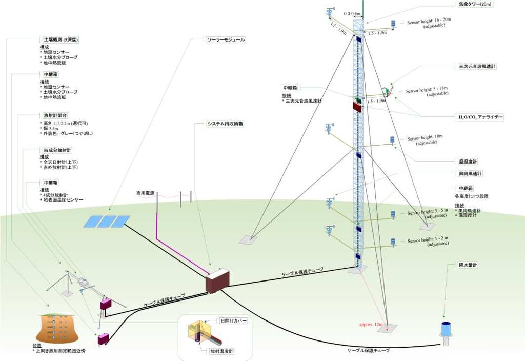
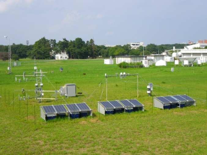
34 Soil Moisture Validation 34 34
35 Summary Satellite community needs upper air network observations for validation, model construction, and so forth. Many satellite missions are being planned worldwide and variety of geophysical parameters will be delivered. Extensive efforts are being made for calibration and validation of satellite products, resulting in increasing demands for accurate ground-based measurements. 35
GCOM-C/SGLI and its Lunar Calibration
 GCOM-C/SGLI and its Lunar Calibration Lunar Calibration Workshop December 1-4, 2014 JAXA/GCOM Proj. Yoshihiko Okamura (okamura.yoshihiko@jaxa.jp) 1. Overview of GCOM-C satellite and SGLI (1) Global Change
Related missions and programs for Snowfall and Snow Hydrology of JAXA
 Related missions and programs for Snowfall and Snow Hydrology of JAXA ALOS AVNIR-2 2006/11/05 Shuji Shimizu Japan Aerospace Exploration Agency (JAXA) Earth Observation Research Center (EORC) JAXA Earth
Status of GCOM and expectation for microwave scatterometer
 Status of GCOM and expectation for microwave scatterometer Keiji Imaoka 1, Misako Kachi 1, Tamotsu Igarashi 1, Keizo Nakagawa 1, Naoto Ebuchi 2, Taikan Oki 1,3, and Haruhisa Shimoda 1,4 1 Japan Aerospace
JAXA Remote Sensing Satellite Missions Utilization for Earth and Environment Observation
 JAXA Remote Sensing Satellite Missions Utilization for Earth and Environment Observation 27 th June 2013 Toshiyoshi Kimura EORC/JAXA Inventory, Modeling and Climate Impacts of Greenhouse Gas emissions
JAXA s Contributions to the Climate Change Monitoring
 0 JAXA s Contributions to the Climate Change Monitoring June 7, 2011 Takao Akutsu Planning Manager Japan Aerospace Exploration Agency (JAXA) Japanese Main Activities of Earth Observation 1 GEOSS 10 years
Agency Status Reports: JMA and JAXA
 Agency Status Reports: JMA and JAXA Kozo Okamoto (JMA : Japan Meteorological Agency) Misako Kachi, Tamotsu Igarashi (JAXA : Japan Aerospace Exploration Agency) JMA Status and plan of MTSAT (Himawari-6
APPENDIX 2 OVERVIEW OF THE GLOBAL PRECIPITATION MEASUREMENT (GPM) AND THE TROPICAL RAINFALL MEASURING MISSION (TRMM) 2-1
 AND THE TROPICAL RAINFALL MEASURING MISSION (TRMM) 2-1") APPENDIX 2 OVERVIEW OF THE GLOBAL PRECIPITATION MEASUREMENT (GPM) AND THE TROPICAL RAINFALL MEASURING MISSION (TRMM) 2-1 1. Introduction Precipitation is one of most important environmental parameters.
APPENDIX 2 OVERVIEW OF THE GLOBAL PRECIPITATION MEASUREMENT (GPM) AND THE TROPICAL RAINFALL MEASURING MISSION (TRMM) 2-1 1. Introduction Precipitation is one of most important environmental parameters.
OVERVIEW OF THE FIRST SATELLITE OF THE GLOBAL CHANGE OBSERVATION MISSION - WATER (GCOM-W1)
") OVERVIEW OF THE FIRST SATELLITE OF THE GLOBAL CHANGE OBSERVATION MISSION - WATER (GCOM-W1) Misako Kachi, Keiji Imaoka, Hideyuki Fujii, Daisaku Uesawa, Kazuhiro Naoki, Akira Shibata, Tamotsu Igarashi, Earth
OVERVIEW OF THE FIRST SATELLITE OF THE GLOBAL CHANGE OBSERVATION MISSION - WATER (GCOM-W1) Misako Kachi, Keiji Imaoka, Hideyuki Fujii, Daisaku Uesawa, Kazuhiro Naoki, Akira Shibata, Tamotsu Igarashi, Earth
JAXA agency report. Masumi MATSUNAGA Satellite Applications and Operations Center(SAOC), JAXA
, JAXA") JAXA agency report Masumi MATSUNAGA Satellite Applications and Operations Center(SAOC), JAXA JAXA Activities Space Transportation Human Space Activities Satellite Programs Lunar & Planetary Exploration
JAXA agency report Masumi MATSUNAGA Satellite Applications and Operations Center(SAOC), JAXA JAXA Activities Space Transportation Human Space Activities Satellite Programs Lunar & Planetary Exploration
Keiji Imaoka Earth Observation Research Center (EORC) Japan Aerospace Exploration Agency (JAXA) GSICS/GRWG Meeting Darmstadt, Germany March 25, 2014
 Japan Aerospace Exploration Agency (JAXA) GSICS/GRWG Meeting Darmstadt, Germany March 25, 2014") Keiji Imaoka Earth Observation Research Center (EORC) Japan Aerospace Exploration Agency (JAXA) GSICS/GRWG Meeting Darmstadt, Germany March 25, 2014 JAXA Satellite Projects Late 1990s 2000s 2003 (JAXA
Keiji Imaoka Earth Observation Research Center (EORC) Japan Aerospace Exploration Agency (JAXA) GSICS/GRWG Meeting Darmstadt, Germany March 25, 2014 JAXA Satellite Projects Late 1990s 2000s 2003 (JAXA
Welcome and Introduction
 Welcome and Introduction Riko Oki Earth Observation Research Center (EORC) Japan Aerospace Exploration Agency (JAXA) 7th Workshop of International Precipitation Working Group 17 November 2014 Tsukuba International
Keiji Imaoka + many contributors. Earth Observation Research Center (EORC) Japan Aerospace Exploration Agency (JAXA)
 Japan Aerospace Exploration Agency (JAXA)") Keiji Imaoka + many contributors Earth Observation Research Center (EORC) Japan Aerospace Exploration Agency (JAXA) Mini-Workshop on A-Train Science Tokyo, Japan March 8, 2013 2 Late 1990s 2000s 2003 (JAXA
Keiji Imaoka + many contributors Earth Observation Research Center (EORC) Japan Aerospace Exploration Agency (JAXA) Mini-Workshop on A-Train Science Tokyo, Japan March 8, 2013 2 Late 1990s 2000s 2003 (JAXA
GCOM-C SGLI calibration and characterization. Hiroshi Murakami JAXA/EORC Satellite instrument pre- and post-launch calibration
 GCOM-C SGLI calibration and characterization Hiroshi Murakami JAXA/EORC Satellite instrument pre- and post-launch calibration 1 1. SGLI sensor system and onboard calibration system Target: Improvement
Contribution to global Earth observation from satellites
 Contribution to global Earth observation from satellites - JAXA s Earth Observation strategy - April 16, 2008 Makoto Kajii Japan Aerospace Exploration Agency Earth Observation Summits and GEOSS 1 st EO
Teruyuki Nakajima Director, Earth Observation Research Center (EORC) Japan Aerospace Exploration Agency (JAXA)
 Japan Aerospace Exploration Agency (JAXA)") Tokyo Inter. Conference on the Forest Governance Initiative - Improving Forest Governance using Forest Early Warning Systems and Satellite Technologies - October 24-26, 2017 Teruyuki Nakajima Director,
Tokyo Inter. Conference on the Forest Governance Initiative - Improving Forest Governance using Forest Early Warning Systems and Satellite Technologies - October 24-26, 2017 Teruyuki Nakajima Director,
Long-term Water Cycle Observation by the Advanced Microwave Scanning Radiometer (AMSR) Series: AMSR-E, AMSR2 and Follow-on
 Series: AMSR-E, AMSR2 and Follow-on") Long-term Water Cycle Observation by the Advanced Microwave Scanning Radiometer (AMSR) Series: AMSR-E, AMSR2 and Follow-on M. Kachi 1), H. Fujii 1), T. Kubota 1), T. Maeda 1), N. Ono 1), M. Kasahara 1),
Long-term Water Cycle Observation by the Advanced Microwave Scanning Radiometer (AMSR) Series: AMSR-E, AMSR2 and Follow-on M. Kachi 1), H. Fujii 1), T. Kubota 1), T. Maeda 1), N. Ono 1), M. Kasahara 1),
GCOM-W1 now on the A-Train
 GCOM-W1 now on the A-Train GCOM-W1 Global Change Observation Mission-Water Taikan Oki, K. Imaoka, and M. Kachi JAXA/EORC (& IIS/The University of Tokyo) Mini-Workshop on A-Train Science, March 8 th, 2013
Pre-Launch Characterization and In-orbit Calibration of GCOM-C/SGLI
 Pre-Launch Characterization and In-orbit Calibration of GCOM-C/SGLI IGARSS 2018 July 26, 2018 Japan Aerospace Exploration Agency Yoshihiko Okamura T. Hashiguchi, T. Urabe, K. Tanaka (JAXA) J Yoshida, T
APPENDIX C OVERVIEW OF THE GLOBAL CHANGE OBSERVATION MISSION (GCOM)
") APPENDIX C OVERVIEW OF THE GLOBAL CHANGE OBSERVATION MISSION (GCOM) C-1 1. Introduction Comprehensive observation, understanding, assessment, and prediction of global climate change are common and important
APPENDIX C OVERVIEW OF THE GLOBAL CHANGE OBSERVATION MISSION (GCOM) C-1 1. Introduction Comprehensive observation, understanding, assessment, and prediction of global climate change are common and important
Japanese Programs on Space and Water Applications
 Japanese Programs on Space and Water Applications Tamotsu IGARASHI Remote Sensing Technology Center of Japan June 2006 COPUOS 2006 Vienna International Centre Water-related hazards/disasters may occur
Interpretation of Polar-orbiting Satellite Observations. Atmospheric Instrumentation
 Interpretation of Polar-orbiting Satellite Observations Outline Polar-Orbiting Observations: Review of Polar-Orbiting Satellite Systems Overview of Currently Active Satellites / Sensors Overview of Sensor
The EarthCARE mission: An active view on aerosols, clouds and radiation
 The EarthCARE mission: An active view on aerosols, clouds and radiation T. Wehr, P. Ingmann, T. Fehr Heraklion, Crete, Greece 08/06/2015 EarthCARE is ESA s sixths Earth Explorer Mission and will be implemented
JAXA S FUTURE EARTH OBSERVATION MISSIONS FOR METEOROLOGICAL AND CLIMATOLOGICAL APPLICATIONS
 JAXA S FUTURE EARTH OBSERVATION MISSIONS FOR METEOROLOGICAL AND CLIMATOLOGICAL APPLICATIONS Misako Kachi, Keiji Imaoka, Hiroshi Murakami, Masahiro Hori, Shuichiro Katagiri, Shuji Shimizu, Riko Oki, and
APPENDIX 1 OVERVIEW OF THE GLOBAL CHANGE OBSERVATION MISSION (GCOM)
") APPENDIX 1 OVERVIEW OF THE GLOBAL CHANGE OBSERVATION MISSION (GCOM) 1-1 1. Introduction Comprehensive observation, understanding, assessment, and prediction of global climate change are common and important
APPENDIX 1 OVERVIEW OF THE GLOBAL CHANGE OBSERVATION MISSION (GCOM) 1-1 1. Introduction Comprehensive observation, understanding, assessment, and prediction of global climate change are common and important
Status of GCOM-W1 and
 Status of GCOM-W1 and GCOM-W2 OVWST Barcelona, Spain May18,2010 Haruhisa Shimoda, Keiji Imaoka, Norimasa Ito, Keizo Nakagawa EORC, JAXA CONTENTS What is GCOM mission AMSR-E status GCOM-W1 satellite GCOM-W1
REVISION OF THE STATEMENT OF GUIDANCE FOR GLOBAL NUMERICAL WEATHER PREDICTION. (Submitted by Dr. J. Eyre)
") WORLD METEOROLOGICAL ORGANIZATION Distr.: RESTRICTED CBS/OPAG-IOS (ODRRGOS-5)/Doc.5, Add.5 (11.VI.2002) COMMISSION FOR BASIC SYSTEMS OPEN PROGRAMME AREA GROUP ON INTEGRATED OBSERVING SYSTEMS ITEM: 4 EXPERT
WORLD METEOROLOGICAL ORGANIZATION Distr.: RESTRICTED CBS/OPAG-IOS (ODRRGOS-5)/Doc.5, Add.5 (11.VI.2002) COMMISSION FOR BASIC SYSTEMS OPEN PROGRAMME AREA GROUP ON INTEGRATED OBSERVING SYSTEMS ITEM: 4 EXPERT
Radio Frequency Earth Science
 Radio Frequency Earth Science Overview for Committee On Radio Frequency (CORF) National Academy of Science National Research Council April 27, 2005 Bill.Watson@NASA.Gov Program Executive for Ground Networks
JAXA s Ocean Environment Monitoring Activities and Himawari Monitor
 JAXA s Ocean Environment Monitoring Activities and Himawari Monitor Misako Kachi, Yukio Kurihara, Hiroshi Murakami, Norimasa Ito (JAXA) Yasumasa Miyazawa (JAMSTEC) IOVWST@Sapporo, 17-19 May, 2016 Research
The EarthCARE mission: An active view on aerosols, clouds and radiation
 The EarthCARE mission: An active view on aerosols, clouds and radiation T. Wehr, T. Fehr, P. Ingmann, J. v. Bismarck ESRIN, Frascati, Italy 20/10/2015 EARTH Clouds, Aerosols and Radiation Explorer EarthCARE
Lecture 19: Operational Remote Sensing in Visible, IR, and Microwave Channels
 MET 4994 Remote Sensing: Radar and Satellite Meteorology MET 5994 Remote Sensing in Meteorology Lecture 19: Operational Remote Sensing in Visible, IR, and Microwave Channels Before you use data from any
Status reports: JMA and JAXA
 Status reports: JMA and JAXA K. Okamoto 1, N. Uekiyo 1 M. Kachi 2, T. Kimura 2 1 : Japan Meteorological Agency (JMA) 2 : Japan Aerospace Exploration Agency (JAXA) ITSC16, Angra dos Reis, Brazil, 7-13 May
Overview of Long- term Observa3ons of the Global Water Cycle by the Advanced Microwave Scanning Radiometer (AMSR) Series
 Series") Overview of Long- term Observa3ons of the Global Water Cycle by the Advanced Microwave Scanning Radiometer (AMSR) Series M. Kachi 1), T. Maeda 1), N. Ono 1), M. Kasahara 1), N. Ebuchi 1),2), and H. Shimoda
Overview of Long- term Observa3ons of the Global Water Cycle by the Advanced Microwave Scanning Radiometer (AMSR) Series M. Kachi 1), T. Maeda 1), N. Ono 1), M. Kasahara 1), N. Ebuchi 1),2), and H. Shimoda
STATUS OF THE FIRST SATELLITE OF THE GLOBAL CHANGE OBSERVATION MISSION - WATER (GCOM-W1)
") STATUS OF THE FIRST SATELLITE OF THE GLOBAL CHANGE OBSERVATION MISSION - WATER (GCOM-W1) Misako Kachi 1, Keiji Imaoka 1, Masahiro Hori 1, Kazuhiro Naoki 1, Takashi Maeda 1, Arata Okuyama 1, Marehiro Kasahara
STATUS OF THE FIRST SATELLITE OF THE GLOBAL CHANGE OBSERVATION MISSION - WATER (GCOM-W1) Misako Kachi 1, Keiji Imaoka 1, Masahiro Hori 1, Kazuhiro Naoki 1, Takashi Maeda 1, Arata Okuyama 1, Marehiro Kasahara
Joint Polar Satellite System. 3 rd Post-EPS User Consultation Workshop Mike Haas
 3 rd Post-EPS User Consultation Workshop Mike Haas Overview Introduction - Policy Drivers - Management System Description - Space Segment - Ground Segment Partnerships Status Benefits 2 Introduction (Policy
"Cloud and Rainfall Observations using Microwave Radiometer Data and A-priori Constraints" Christian Kummerow and Fang Wang Colorado State University
 "Cloud and Rainfall Observations using Microwave Radiometer Data and A-priori Constraints" Christian Kummerow and Fang Wang Colorado State University ECMWF-JCSDA Workshop Reading, England June 16-18, 2010
EUMETSAT STATUS AND PLANS
 1 EUM/TSS/VWG/15/826793 07/10/2015 EUMETSAT STATUS AND PLANS François Montagner, Marine Applications Manager, EUMETSAT WMO Polar Space Task Group 5 5-7 October 2015, DLR, Oberpfaffenhofen PSTG Strategic
Development of Spaceborne Dualfrequency. and Its Role for the Global Precipitation Measurement
 Development of Spaceborne Dualfrequency Precipitation Radar and Its Role for the Global Precipitation Measurement Shinsuke Satoh (1), Riko Oki (1), Nobuhiro Takahashi (2), and Toshio Iguchi (2) (1) National
Global Flood Alert System based on satellite derived rainfall data -Targeting the era of Global Precipitation Measurement (GPM)-
-") Global Flood Alert System based on satellite derived rainfall data -Targeting the era of Global Precipitation Measurement (GPM)- Riko Oki, Misako Kachi (JAXA/EORC) Kazuhiko Fukami (PWRI) and Kazuo Umeda
Global Flood Alert System based on satellite derived rainfall data -Targeting the era of Global Precipitation Measurement (GPM)- Riko Oki, Misako Kachi (JAXA/EORC) Kazuhiko Fukami (PWRI) and Kazuo Umeda
Influence of Clouds and Aerosols on the Earth s Radiation Budget Using Clouds and the Earth s Radiant Energy System (CERES) Measurements
 Measurements") Influence of Clouds and Aerosols on the Earth s Radiation Budget Using Clouds and the Earth s Radiant Energy System (CERES) Measurements Norman G. Loeb Hampton University/NASA Langley Research Center Bruce
Influence of Clouds and Aerosols on the Earth s Radiation Budget Using Clouds and the Earth s Radiant Energy System (CERES) Measurements Norman G. Loeb Hampton University/NASA Langley Research Center Bruce
Remote Sensing I: Basics
 Remote Sensing I: Basics Kelly M. Brunt Earth System Science Interdisciplinary Center, University of Maryland Cryospheric Science Laboratory, Goddard Space Flight Center kelly.m.brunt@nasa.gov (Based on
CEOS Overview and JAXA Plans for Water Cycle Observation
 CEOS Overview and JAXA Plans for Water Cycle Observation Asian Water Cycle Symposium November 2-4, 2005 Tokyo, Japan Chu Ishida Japan Aerospace Exploration Agency (JAXA) Contents 1. CEOS overview 2. CEOS
The use and impacts of sea surface temperature from passive microwave measurements
 The use and impacts of sea surface temperature from passive microwave measurements Anne O Carroll 6/12/2017 ECMWF workshop on using low frequency passive microwave measurements in research and operational
Atmospheric Lidar The Atmospheric Lidar (ATLID) is a high-spectral resolution lidar and will be the first of its type to be flown in space.
 is a high-spectral resolution lidar and will be the first of its type to be flown in space.") www.esa.int EarthCARE mission instruments ESA s EarthCARE satellite payload comprises four instruments: the Atmospheric Lidar, the Cloud Profiling Radar, the Multi-Spectral Imager and the Broad-Band Radiometer.
www.esa.int EarthCARE mission instruments ESA s EarthCARE satellite payload comprises four instruments: the Atmospheric Lidar, the Cloud Profiling Radar, the Multi-Spectral Imager and the Broad-Band Radiometer.
GOSAT update. June Prepared by JAXA EORC Presented by David Crisp
 CEOS AC-VC GOSAT update June Prepared by JAXA EORC Presented by David Crisp GOSAT & GOSAT-2 Organization ORGANIZATION GOSAT is the joint project of JAXA, MOE (Ministry of the Environment) and NIES (National
CMA Consideration on early-morning orbit satellite
 CMA Consideration on early-morning orbit satellite National Satellite Meteorological Center,CMA Yang Jun CGMS 40 in Lugano, 5-9 Nov., 2012 Outline Background Gap analysis on the sounding data coverage
CGMS Baseline. Sustained contributions to the Global Observing System. Endorsed by CGMS-46 in Bengaluru, June 2018
 CGMS Baseline Sustained contributions to the Global Observing System Best Practices for Achieving User Readiness for New Meteorological Satellites Endorsed by CGMS-46 in Bengaluru, June 2018 CGMS/DOC/18/1028862,
Mission Objectives and Current Status of GOSAT (IBUKI) Japan Aerospace Exploration Agency Yasushi Horikawa
 Japan Aerospace Exploration Agency Yasushi Horikawa") Mission Objectives and Current Status of GOSAT (IBUKI) Japan Aerospace Exploration Agency Yasushi Horikawa 1 Background of the Launch of the GOSAT project 1997 Adoption of the Kyoto Protocol 2002 Ratification
Mission Objectives and Current Status of GOSAT (IBUKI) Japan Aerospace Exploration Agency Yasushi Horikawa 1 Background of the Launch of the GOSAT project 1997 Adoption of the Kyoto Protocol 2002 Ratification
Meteorological Satellite Image Interpretations, Part III. Acknowledgement: Dr. S. Kidder at Colorado State Univ.
 Meteorological Satellite Image Interpretations, Part III Acknowledgement: Dr. S. Kidder at Colorado State Univ. Dates EAS417 Topics Jan 30 Introduction & Matlab tutorial Feb 1 Satellite orbits & navigation
REMOTE SENSING KEY!!
 REMOTE SENSING KEY!! This is a really ugly cover page I m sorry. Name Key. Score / 100 Directions: You have 50 minutes to take this test. You may use a cheatsheet (2 pages), a non-graphing calculator,
Instrumentation planned for MetOp-SG
 Instrumentation planned for MetOp-SG Bill Bell Satellite Radiance Assimilation Group Met Office Crown copyright Met Office Outline Background - the MetOp-SG programme The MetOp-SG instruments Summary Acknowledgements:
Satellite observation of atmospheric dust
 Satellite observation of atmospheric dust Taichu Y. Tanaka Meteorological Research Institute, Japan Meteorological Agency 11 April 2017, SDS WAS: Dust observation and modeling @WMO, Geneva Dust observations
Lectures 7 and 8: 14, 16 Oct Sea Surface Temperature
 Lectures 7 and 8: 14, 16 Oct 2008 Sea Surface Temperature References: Martin, S., 2004, An Introduction to Ocean Remote Sensing, Cambridge University Press, 454 pp. Chapter 7. Robinson, I. S., 2004, Measuring
F O U N D A T I O N A L C O U R S E
 F O U N D A T I O N A L C O U R S E December 6, 2018 Satellite Foundational Course for JPSS (SatFC-J) F O U N D A T I O N A L C O U R S E Introduction to Microwave Remote Sensing (with a focus on passive
HY-2A Satellite User s Guide
 National Satellite Ocean Application Service 2013-5-16 Document Change Record Revision Date Changed Pages/Paragraphs Edit Description i Contents 1 Introduction to HY-2 Satellite... 1 2 HY-2 satellite data
GLOBAL PRECIPITATION MEASUREMENT UPDATE
 GLOBAL PRECIPITATION MEASUREMENT UPDATE Gilbert Mark Flaming National Aeronautics and Space Administration Goddard Space Flight Center Code 420.2 Greenbelt, Maryland 20771 USA Email: gilbert.m.flaming@nasa.gov
JAXA s satellites for Disaster Management and Climate Change
 JAXA s satellites for Disaster Management and Climate Change August 24, 2017 Masanobu TSUJI Japan Aerospace Exploration Agency (JAXA) JAXA Activities Space Transportation Human Space Activities Satellite
CGMS Baseline In response to CGMS action/recommendation A45.01 HLPP reference: 1.1.8
 Prepared by WGIII Agenda Item: 7.1 Discussed in WGIII CGMS Baseline In response to CGMS action/recommendation A45.01 HLPP reference: 1.1.8 In CGMS-45, Working Group III agreed to hold a review of the CGMS
Remote Sensing in Meteorology: Satellites and Radar. AT 351 Lab 10 April 2, Remote Sensing
 Remote Sensing in Meteorology: Satellites and Radar AT 351 Lab 10 April 2, 2008 Remote Sensing Remote sensing is gathering information about something without being in physical contact with it typically
Future Opportunities of Using Microwave Data from Small Satellites for Monitoring and Predicting Severe Storms
 Future Opportunities of Using Microwave Data from Small Satellites for Monitoring and Predicting Severe Storms Fuzhong Weng Environmental Model and Data Optima Inc., Laurel, MD 21 st International TOV
JPSS GEONETCAST REQUIREMENTS DISCUSSION
 Joint Polar Satellite System (JPSS) JPSS GEONETCAST REQUIREMENTS DISCUSSION Mitch Goldberg Program Scientist Joint Polar Satellite System National Environmental Satellite, Data, and Information Service
Status of Indian Satellite Meteorological Programme
 Status of Indian Satellite Meteorological Programme Pradeep K Thapliyal Space Applications Centre (SAC) Indian Space research Organisation (ISRO) Ahmedabad (INDIA) Email: pkthapliyal@sac.isro.gov.in International
REMOTE SENSING TEST!!
 REMOTE SENSING TEST!! This is a really ugly cover page I m sorry. Name. Score / 100 Directions: (idk if I need to put this???) You have 50 minutes to take this test. You may use a cheatsheet (2 pages),
Lecture 4b: Meteorological Satellites and Instruments. Acknowledgement: Dr. S. Kidder at Colorado State Univ.
 Lecture 4b: Meteorological Satellites and Instruments Acknowledgement: Dr. S. Kidder at Colorado State Univ. US Geostationary satellites - GOES (Geostationary Operational Environmental Satellites) US
URSI-F Microwave Signatures Meeting 2010, Florence, Italy, October 4 8, Thomas Meissner Lucrezia Ricciardulli Frank Wentz
 URSI-F Microwave Signatures Meeting 2010, Florence, Italy, October 4 8, 2010 Wind Measurements from Active and Passive Microwave Sensors High Winds and Winds in Rain Thomas Meissner Lucrezia Ricciardulli
NEW CANDIDATE EARTH EXPLORER CORE MISSIONS THEIR IMPORTANCE FOR ATMOSPHERIC SCIENCE AND APPLICATION
 NEW CANDIDATE EARTH EXPLORER CORE MISSIONS THEIR IMPORTANCE FOR ATMOSPHERIC SCIENCE AND APPLICATION P. Ingmann and J. Langen European Space Research and Technology Centre (ESTEC) P.O. Box 299, NL-2200
Aerosols from Sentinel 3 and EarthCARE missions
 Aerosols from Sentinel 3 and EarthCARE missions Michael Eisinger, Tobias Wehr, Dulce Lajas, Alain Lefebvre European Space Agency Aerosol Observability Workshop 27-29 April 2010 Monterey, CA Page 1 Outline
Synergistic Use of Spaceborne Active Sensors and Passive Multispectral Imagers for Investigating Cloud Evolution Processes
 Trans. JSASS Aerospace Tech. Japan Vol. 12, No. ists29, pp. Tn_19-Tn_24, 2014 Topics Synergistic Use of Spaceborne Active Sensors and Passive Multispectral Imagers for Investigating Cloud Evolution Processes
History of Aerosol Remote Sensing. Mark Smithgall Maria Zatko 597K Spring 2009
 History of Aerosol Remote Sensing Mark Smithgall Maria Zatko 597K Spring 2009 Aerosol Sources Anthropogenic Biological decomposition from fertilizer and sewage treatment (ex. ammonium) Combustion of fossil
CLOUD AND PRECIPITATION OBSERVATION BY SPACEBORNE RADAR IN JAPAN: CURRENT AND FUTURE MISSIONS
 CLOUD AND PRECIPITATION OBSERVATION BY SPACEBORNE RADAR IN JAPAN: CURRENT AND FUTURE MISSIONS R. Oki a, T. Kubota a *, S. Katagiri a, M. Kachi a, S. Shimizu a, M. Kojima b, K. Kimura c a Earth Observation
EPS-SG Candidate Observation Missions
 EPS-SG Candidate Observation Missions 3 rd Post-EPS User Consultation Workshop Peter Schlüssel Slide: 1 EPS-SG benefits to activities of NMSs Main Payload High-Resolution Infrared Sounding Microwave Sounding
The current status of FY-3D. (Submitted by Xiang Fang, CMA) Summary and Purpose of Document
 Summary and Purpose of Document") WORLD METEOROLOGICAL ORGANIZATION COMMISSION FOR BASIC SYSTEMS OPEN PROGRAMME AREA GROUP ON INTEGRATED OBSERVING SYSTEMS INTER-PROGRAMME EXPERT TEAM ON SATELLITE UTILIZATION AND PRODUCTS FOURTH SESSION
WORLD METEOROLOGICAL ORGANIZATION COMMISSION FOR BASIC SYSTEMS OPEN PROGRAMME AREA GROUP ON INTEGRATED OBSERVING SYSTEMS INTER-PROGRAMME EXPERT TEAM ON SATELLITE UTILIZATION AND PRODUCTS FOURTH SESSION
School on Modelling Tools and Capacity Building in Climate and Public Health April Remote Sensing
 2453-5 School on Modelling Tools and Capacity Building in Climate and Public Health 15-26 April 2013 Remote Sensing CECCATO Pietro International Research Institute for Climate and Society, IRI The Earth
Evaluation of Regressive Analysis Based Sea Surface Temperature Estimation Accuracy with NCEP/GDAS Data
 Evaluation of Regressive Analysis Based Sea Surface Temperature Estimation Accuracy with NCEP/GDAS Data Kohei Arai 1 Graduate School of Science and Engineering Saga University Saga City, Japan Abstract
National Aeronautics and Space Administration. Earth Day is everyday at NASA. activity booklet
 National Aeronautics and Space Administration Earth Day is everyday at NASA activity booklet Earth Day is everyday at NASA NASA s Fleet of Earth Observing Satellites ACRIMSAT Landsat 7 Aqua SORCE Terra
On the Satellite Determination of Multilayered Multiphase Cloud Properties. Science Systems and Applications, Inc., Hampton, Virginia 2
 JP1.10 On the Satellite Determination of Multilayered Multiphase Cloud Properties Fu-Lung Chang 1 *, Patrick Minnis 2, Sunny Sun-Mack 1, Louis Nguyen 1, Yan Chen 2 1 Science Systems and Applications, Inc.,
The current status of FY-3D
 The current status of FY-3D Xiang Fang National Satellite Meteorological Center, China Meteorological Administration (NSMC/CMA) OUTLINE Overview Key instruments onboard FY-3D Products and data service
Thermal And Near infrared Sensor for carbon Observation (TANSO) On board the Greenhouse gases Observing SATellite (GOSAT) Research Announcement
 On board the Greenhouse gases Observing SATellite (GOSAT) Research Announcement") Thermal And Near infrared Sensor for carbon Observation (TANSO) On board the Greenhouse gases Observing SATellite (GOSAT) Research Announcement Appendix A Outlines of GOSAT and TANSO Sensor GOSAT (Greenhouse
Thermal And Near infrared Sensor for carbon Observation (TANSO) On board the Greenhouse gases Observing SATellite (GOSAT) Research Announcement Appendix A Outlines of GOSAT and TANSO Sensor GOSAT (Greenhouse
3. Carbon Dioxide (CO 2 )
") 3. Carbon Dioxide (CO 2 ) Basic information on CO 2 with regard to environmental issues Carbon dioxide (CO 2 ) is a significant greenhouse gas that has strong absorption bands in the infrared region and
3. Carbon Dioxide (CO 2 ) Basic information on CO 2 with regard to environmental issues Carbon dioxide (CO 2 ) is a significant greenhouse gas that has strong absorption bands in the infrared region and
GEOSC/METEO 597K Kevin Bowley Kaitlin Walsh
 GEOSC/METEO 597K Kevin Bowley Kaitlin Walsh Timeline of Satellites ERS-1 (1991-2000) NSCAT (1996) Envisat (2002) RADARSAT (2007) Seasat (1978) TOPEX/Poseidon (1992-2005) QuikSCAT (1999) Jason-2 (2008)
New NASA Ocean Observations and Coastal Applications
 New NASA Ocean Observations and Coastal Applications Duane Armstrong Chief, Applied Science & Technology Project Office August 20, 2014 1 Outline NASA s new Earth Science Ocean Science Missions for 2014
Project update from JAXA: GCOM-C1/SGLI
 Project update from JAXA: GCOM-C1/SGLI GCOM-C1: Global Change Observation Mission Climate, 1st satellite SGLI: Second-generation GLobal Imager Hiroshi Murakami JAXA/EORC ICAP 2013 Tsukuba Working group
GIFTS SOUNDING RETRIEVAL ALGORITHM DEVELOPMENT
 P2.32 GIFTS SOUNDING RETRIEVAL ALGORITHM DEVELOPMENT Jun Li, Fengying Sun, Suzanne Seemann, Elisabeth Weisz, and Hung-Lung Huang Cooperative Institute for Meteorological Satellite Studies (CIMSS) University
A two-season impact study of the Navy s WindSat surface wind retrievals in the NCEP global data assimilation system
 A two-season impact study of the Navy s WindSat surface wind retrievals in the NCEP global data assimilation system Li Bi James Jung John Le Marshall 16 April 2008 Outline WindSat overview and working
Use of FY-3C/GNOS Data for Assessing the on-orbit Performance of Microwave Sounding Instruments
 Use of FY-3C/GNOS Data for Assessing the on-orbit Performance of Microwave Sounding Instruments Xiuqing Hu 1 Xueyan Hou 2, and Mi Liao 1 1 National Satellite Meteorological Center (NSMC), CMA 2 Chinese
Variability in Global Top-of-Atmosphere Shortwave Radiation Between 2000 And 2005
 Variability in Global Top-of-Atmosphere Shortwave Radiation Between 2000 And 2005 Norman G. Loeb NASA Langley Research Center Hampton, VA Collaborators: B.A. Wielicki, F.G. Rose, D.R. Doelling February
JAXA s satellites for Disaster Risk Reduction
 JAXA s satellites for Disaster Risk Reduction October 9, 2017 Masanobu TSUJI Japan Aerospace Exploration Agency (JAXA) Panel on Space Technology and Applications in Support of theregional Roadmap for Implementing
Monitoring Air Pollution from Space
 Monitoring Air Pollution from Space Media Regional Training Workshop 16 th Nov 20 th Nov 2015 Shreta Ghimire International Centre for Integrated Mountain Development Kathmandu, Nepal Why do we study air
Japan s efforts of using satellite remote sensing for the prediction of infectious diseases
 Japan s efforts of using satellite remote sensing for the prediction of infectious diseases 28 August, 2013 MEDGEO2013, ISPRS Earth Observing Data and Tools for Health Studies Hilton Crystal City Hotel
McIDAS support of Suomi-NPP /JPSS and GOES-R L2
 McIDAS support of Suomi-NPP /JPSS and GOES-R L2 William Straka III 1 Tommy Jasmin 1, Bob Carp 1 1 Cooperative Institute for Meteorological Satellite Studies, Space Science and Engineering Center, University
FLUXNET and Remote Sensing Workshop: Towards Upscaling Flux Information from Towers to the Globe
 FLUXNET and Remote Sensing Workshop: Towards Upscaling Flux Information from Towers to the Globe Space-Based Measurements of CO 2 from the Japanese Greenhouse Gases Observing Satellite (GOSAT) and the
Course outline, objectives, workload, projects, expectations
 Course outline, objectives, workload, projects, expectations Introductions Remote Sensing Overview Elements of a remote sensing observing system 1. platform (satellite, surface, etc) 2. experimental design
Operational systems for SST products. Prof. Chris Merchant University of Reading UK
 Operational systems for SST products Prof. Chris Merchant University of Reading UK Classic Images from ATSR The Gulf Stream ATSR-2 Image, ƛ = 3.7µm Review the steps to get SST using a physical retrieval
Long-Term Time Series of Water Vapour Total Columns from GOME, SCIAMACHY and GOME-2
 Graphics: ESA Graphics: ESA Graphics: ESA Long-Term Time Series of Water Vapour Total Columns from GOME, SCIAMACHY and GOME-2 S. Noël, S. Mieruch, H. Bovensmann, J. P. Burrows Institute of Environmental
Model errors in tropical cloud and precipitation revealed by the assimilation of MW imagery
 Model errors in tropical cloud and precipitation revealed by the assimilation of MW imagery Katrin Lonitz, Alan Geer, Philippe Lopez + many other colleagues 20 November 2014 Katrin Lonitz ( ) Tropical
GOSAT mission schedule
 GOSAT mission schedule 29 21 12 1 2 3 4 6 7 8 9 1 11 12 1 2 214 1 2 3 ~ Jan. 23 Launch Initial Checkout Initial function check Initial Cal. and Val. Mission life Normal observation operation Extra Operati
Vicarious calibration of GLI by global datasets. Calibration 5th Group Hiroshi Murakami (JAXA EORC)
") Vicarious calibration of GLI by global datasets Calibration 5th Group Hiroshi Murakami (JAXA EORC) ADEOS-2 PI workshop March 2004 1 0. Contents 1. Background 2. Operation flow 3. Results 4. Temporal change
Vicarious calibration of GLI by global datasets Calibration 5th Group Hiroshi Murakami (JAXA EORC) ADEOS-2 PI workshop March 2004 1 0. Contents 1. Background 2. Operation flow 3. Results 4. Temporal change
Thermal And Near infrared Sensor for carbon Observation (TANSO) onboard the Greenhouse gases Observing SATellite (GOSAT) Research Announcement
 onboard the Greenhouse gases Observing SATellite (GOSAT) Research Announcement") Thermal And Near infrared Sensor for carbon Observation (TANSO) onboard the Greenhouse gases Observing SATellite (GOSAT) Research Announcement Appendix C Operation Policies of GOSAT and Basic Observation
Thermal And Near infrared Sensor for carbon Observation (TANSO) onboard the Greenhouse gases Observing SATellite (GOSAT) Research Announcement Appendix C Operation Policies of GOSAT and Basic Observation
TRMM, Hydrologic Science, and Societal Benefit: The Role of Satellite Measurements
 TRMM, Hydrologic Science, and Societal Benefit: The Role of Satellite Measurements Michael H. Freilich TRMM 15 th Anniversary Symposium 12 November 2012 KEY TRMM ATTRIBUTES Long on-orbit lifetime 15 years
Solar Insolation and Earth Radiation Budget Measurements
 Week 13: November 19-23 Solar Insolation and Earth Radiation Budget Measurements Topics: 1. Daily solar insolation calculations 2. Orbital variations effect on insolation 3. Total solar irradiance measurements
Masahiro Kazumori, Takashi Kadowaki Numerical Prediction Division Japan Meteorological Agency
 Development of an all-sky assimilation of microwave imager and sounder radiances for the Japan Meteorological Agency global numerical weather prediction system Masahiro Kazumori, Takashi Kadowaki Numerical