Keiji Imaoka + many contributors. Earth Observation Research Center (EORC) Japan Aerospace Exploration Agency (JAXA)
|
|
|
- Alfred Wheeler
- 5 years ago
- Views:
Transcription
 Mini-Workshop on A-Train Science Tokyo, Japan March")
1 Keiji Imaoka + many contributors Earth Observation Research Center (EORC) Japan Aerospace Exploration Agency (JAXA) Mini-Workshop on A-Train Science Tokyo, Japan March 8, 2013

2 2

")


3 Late 1990s 2000s 2003 (JAXA established) Earth Observation ADEOS Climate Change/Water GPM/DPR ADEOS-Ⅱ GCOM-W GCOM-C EarthCARE/ CPR TRMM/PR Aqua/ AMSR-E GOSAT Global Warming Land Use Communications ALOS Disaster Monitoring ALOS-2 ALOS 3 COMETS DRTS WINDS Technology Development Positioning QZSS ETS-Ⅵ ETS-Ⅶ OICETS ETS-Ⅷ 3
4 Demonstrate long-term global observation of various geophysical parameters for understanding climate variability and water cycle. Two medium-sized satellites with three generations to ensure years stable data records. 5-year Launch 2012 GCOM-W1 Operation extension GCOM-W2 1-year overlap GCOM-W3 Launch 2015 GCOM-C1 GCOM-C2 GCOM-C3 4
5 cloud liquid water soil mois- ture snow ice distribu- tion sea ice concen- tration. ocean color water vapor cloud proper- ties snow depth snow surface temp. land cover land surface tempera- ture sea surface temp. sea surface wind speed precipi- tation aerosol proper- ties snow surface proper- ties above- ground bio- mass primary produc- tion PAR Land Ocean Cryosphere Atmosphere C Radiation Budget C Carbon Cycle W Water & Energy Cycle 5
 Inclination: 98.")
6 GCOM 1 st Generation Satellites 2 types of medium-sized satellites and 3 generations: years observation SHIZUKU GCOM-W1 (Water) GCOM-C1 (Climate) Instrument Advanced Microwave Scanning Radiometer-2 Instrument Second-generation Global Imager Orbit Sun Synchronous orbit Altitude:699.6km (on Equator) Inclination: 98.2 degrees Local sun time: 13:30+/-15 min Orbit Sun Synchronous orbit Altitude:798km (on Equator) Inclination: 98.6 deg. Local sun time: 10:30+/- 15min Size 5.1m (X) * 17.5m (Y) * 3.4m (Z) (on-orbit) Size 4.6m (X) * 16.3m (Y) * 2.8m (Z) (on orbit) Mass 1991kg Mass 2093kg Power gen. More than 3880W (EOL) Power gen. More than 4000W (EOL) Launch May 18, 2012 Launch JFY 2015 (TBD) Design Life 5-years Design Life 5-years 6
 spatial resolution polarization/along-track slant view GCOM-C SGLI characteristics (Current baseline) Sun-synchronous (descending local time: Orbit 10:30) Altitude: 798km, Inclination: 98.")
7 Improvement of land, coastal, and aerosol observations. fine (250m) spatial resolution polarization/along-track slant view GCOM-C SGLI characteristics (Current baseline) Sun-synchronous (descending local time: Orbit 10:30) Altitude: 798km, Inclination: 98.6deg Launch Date Jan (HII-A) Mission Life 5 years (3 satellites; total 13 years) Push-broom electric scan (VNR: VN & P) Scan Wisk-broom mechanical scan (IRS: SW & T) 1150km cross track (VNR: VN & P) Scan width 1400km cross track (IRS: SW & T) Digitalization 12bit Multi-angle Polarization 3 polarization angles for P obs. for Along track Nadir for VN, SW and T, 674nm and direction +45 deg and -45 deg for P 869nm VN: Solar diffuser, Internal lamp (LED, halogen), Lunar by pitch maneuvers (~once/month), and dark current by masked pixels and nighttime obs. On-board SW: Solar diffuser, Internal lamp, Lunar, and calibration dark current by deep space window T: Black body and dark current by deep space window All: Electric calibration 250m over land or coastal area, and 1km over offshore SGLI channels λ λ L std L max SNR at Lstd IFOV VN, P: CH VN, P, SW: nm W/m T: µm VN, P, SW: - /sr/µm T: NE T T: Kelvin m VN VN VN VN VN VN VN VN VN (@1km) 250 VN VN P P SW SW SW SW T /250 T / m-mode possibility 7
8 Late 1990s 2000s 2003 (JAXA established) Earth Observation ADEOS Climate Change/Water GPM/DPR ADEOS-Ⅱ GCOM-W GCOM-C EarthCARE/ CPR TRMM/PR Aqua/ AMSR-E GOSAT Global Warming Land Use Communications ALOS Disaster Monitoring ALOS-2 ALOS 3 COMETS DRTS WINDS Technology Development Positioning QZSS ETS-Ⅵ ETS-Ⅶ OICETS ETS-Ⅷ 8

 GPM/DPR (by JAXA/NICT) 1997~Today")
 Ka-band(35.")

 2006~Today 2015~ full spectrum of")
9 Spaceborne Cloud & Precipitation Radar Development TRMM/PR (by JAXA/NICT) Ku-band(13.8GHz) GPM/DPR (by JAXA/NICT) 1997~Today 2014~ long term global precipitation record Ku-band(13.6GHz) Ka-band(35.5GHz) EarthCARE/CPR (by JAXA/NICT) W-band(94.05GHz) (Doppler radar) CloudSat/CPR (by NASA) 2006~Today 2015~ full spectrum of cloud and precipitation (cloud - weak rain- heavy rain) W-band(94GHz) 9
 to observe diurnal variation.")
 Japan: PR, launch US: satellite, TMI, VIRS, CERES, LIS, operation")
10 Tropical Rainfall Measuring Mission - TRMM - Focused on rainfall observation. First instantaneous rainfall observation by three different sensors (PR, TMI, VIRS). PR, active sensor, can observe 3D structure of rainfall. Targeting tropical and subtropical region, and chose non-sunsynchronous orbit (inc. angle 35 degree) to observe diurnal variation. Launch 28 Nov (JST) Altitude About 350km (since 2001, boosted to 402km to extend mission operation) Inc. angle Design life Instruments US-Japan joint mission About 35 degree, non-sunsynchronous orbit 3-year and 2month (still operating) Japan: PR, launch US: satellite, TMI, VIRS, CERES, LIS, operation Precipitation Radar (PR) TRMM Microwave Imager (TMI) Visible Infrared Scanner (VIRS) Lightning Imaging Sensor (LIS) CERES (not in operation) 10
 Rapidly")


11 Typhoon MORAKOT (09W): Aug. 5 10, 2009 (Big impact in Chinese Taipei) Rapidly changing precipitation phenomena need frequent observations. Global rainfall map merging TRMM, polar orbiting microwave radiometer/sounders, and geostationary infrared radiometers. 11
 Precipitation with high precision Discrimination between rain and snow Adjustment of data from constellation satellites (The core satellite will fly in non-sun-synchronous")
 TRMM Era Core Satellite Constellation Satellites (International Partners) Microwave radiometers Microwave sounders Global precipitation every 3 hours (launch in 2014) (launch around 2014) 2")
12 GPM: An international satellite mission to be launched by JAXA and NASA in 2014 for precipitation measurements worldwide Core Satellite (JAXA, NASA) Dual-frequency precipitation radar (DPR) GPM Microwave Imager (GMI) Precipitation with high precision Discrimination between rain and snow Adjustment of data from constellation satellites (The core satellite will fly in non-sun-synchronous orbit.) TRMM Era Core Satellite Constellation Satellites (International Partners) Microwave radiometers Microwave sounders Global precipitation every 3 hours (launch in 2014) (launch around 2014) 2 satellites/3hr GPM Era Constellation Satellites Improve the accuracy of both long-term and short-term weather forecasts Improve water resource management in river control and irrigation systems for agriculture 8 satellites/3hr 12
 radar : KaPR DPR GMI Flight direction 407 km altitude, 65 deg inclination GMI: GPM Microwave Imager The DPR was developed by JAXA and NICT. Range resolution = 250m and 500m KuPR (13.")
13 Dual-frequency precipitation radar (DPR) consists of -Ku-band (13.6GHz) radar : KuPR (similar to TRMM/PR) and -Ka-band (35.5GHz) radar : KaPR DPR GMI Flight direction 407 km altitude, 65 deg inclination GMI: GPM Microwave Imager The DPR was developed by JAXA and NICT. Range resolution = 250m and 500m KuPR (13.6GHz) Swath width = 245km KaPR (35.5GHz) Swath width = 120km Microwave radiometer Swath width = 800 km 5km 13


14 KuPR PFM KaPR PFM under integration Satellite Photo Credit: NASA 14

15 15 15 To reduce the uncertainties in global warming prediction by measuring the three dimensional structure of clouds and aerosols, which are most uncertain parameter in the numerical climate models. Joint Mission by Europe and Japan 3 years lifetime 400 km altitude Sun-synchronous orbit (Local time: 14:00)
 - Atmospheric")
 CPR")
16 16 16 CPR Four instruments - Cloud Profiling RADAR (JAXA/NICT) - Atmospheric LIDAR (ESA) - Multi-Spectral Imager (ESA) - Broad Band Radiometer (ESA) CPR Engineering Model

17 17 EarthCARE CPR is the first millimeter-wave Doppler radar in space for Earth observation developed by JAXA and NICT. 94GHz of W-band is selected for center frequency to penetrate deep into the clouds from the orbit and retrieve the cloud vertical profiles and motions. The antenna employs offset Cassegrain type, and has a deployable main reflector with the largest aperture for W-band Earth observation satellite. CPR observes clouds along the sub-satellite track. External view of CPR 2.5mΦ Observation image by Cloud Profiling Radar This image is from NASA/CloudSat quick look data and edited 17
18 Late 1990s 2000s 2003 (JAXA established) Earth Observation ADEOS Climate Change/Water GPM/DPR ADEOS-Ⅱ GCOM-W GCOM-C EarthCARE/ CPR TRMM/PR Aqua/ AMSR-E GOSAT Global Warming Land Use Communications ALOS Disaster Monitoring ALOS-2 ALOS 3 COMETS DRTS WINDS Technology Development Positioning QZSS ETS-Ⅵ ETS-Ⅶ OICETS ETS-Ⅷ 18
, and MOE (Ministry of the Environment).")
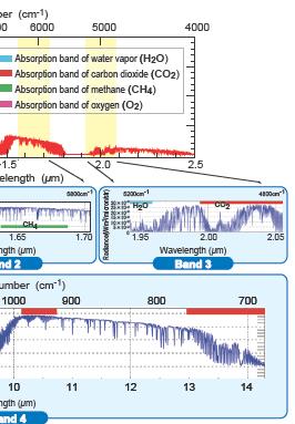
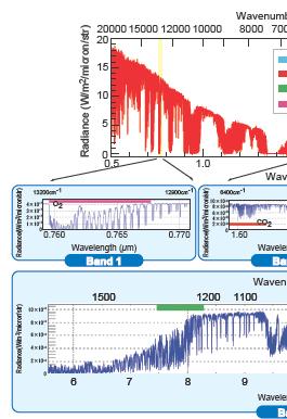
19 Monitoring global distribution of Greenhouse Gases from space. Observe Carbon dioxide and Methane at km spatial scale with relative accuracy of 1% (4ppm) for CO2 and 2% (34ppb) for CH4. Joint project by JAXA, NIES (National Institute for Environmental Studies), and MOE (Ministry of the Environment). Launch: 23 January 2009 by H2A launch vehicle Mission lifetime: 5 years to 2014 GOSAT satellite at Tanegashima Spece Center 19


")
20 20 TANSO= Thermal And Near infrared Sensor for carbon Observation TANSO-FTS (Fourier Transform Spectrometer) TANSO-CAI (Cloud and Aerosol Imager)
21 21 21
22 Late 1990s 2000s 2003 (JAXA established) Earth Observation ADEOS Climate Change/Water GPM/DPR ADEOS-Ⅱ GCOM-W GCOM-C EarthCARE/ CPR TRMM/PR Aqua/ AMSR-E GOSAT Global Warming Land Use Communications ALOS Disaster Monitoring ALOS-2 ALOS 3 COMETS DRTS WINDS Technology Development Positioning QZSS ETS-Ⅵ ETS-Ⅶ OICETS ETS-Ⅷ 22
 > 1,934 days=5.")


23 Operation: 24 Jan by H-2A Rocket #8 12 May 2011 Mission ended ~22 Apr. 2011: Low Load Mode (LLM) > 1,934 days=5.3 years PRISM Objectives: Cartography (1/25,000 scale) Regional environmental monitoring Disaster monitoring, etc. PALSAR PRISM AVNIR-2 Panchromatic Remote sensing Advanced Visible and Near-Infrared Instrument for Stereo Mapping Radiometer type 2 AVNIR-2 PALSAR Phased Array type L-band Synthetic Aperture Radar PRISM can acquire triplet stereo imageries by nadir-, forward-, and backward-radiometers with 2.5m spatial resolution in 35km swath. AVNIR-2 can observe with 10m resolution in 70km swath, and it can be changed the observation area by pointing capability within +/-44 deg. in across track. PALSAR can acquire the data in not only daytime but also nighttime as well as cloudy and rainy whether conditions. 23

 ALOS-3 (Optical)")


 and wide")
 Fine and clear images")
24 24 Global and high resolution observation by radar and optical sensors ALOS (Radar&Optical) ALOS-2 (Radar) ALOS-3 (Optical) Hyper multi sensor L-band radar antenna Optical sensors L-band radar antenna Launch: JFY2013 Panchromatic sensor Launch: JFY2016 (Target) High resolution (1-3 m) and wide observation area ( km swath) Fine and clear images under the heavy rain or night condition

25 25


 CO2 Lidar,")
26 SMILES: Detection of atmospheric limb emission in the submillimeter wave range ( GHz) with high sensitivity. NICT and JAXA cooperation. JAXA is promoting EO missions such as: Live broadcasting of global phenomena by astronauts Kibo Exposed Facility payloads Compact InfraRed Camera (CIRC) CO2 Lidar, Doppler lidar, etc. SMILES CIRC 26


 Diurnal")
27 27 ilove iss-jem Lidar Observation of Vegetation Environment Tree canopy height, Biomass APOLLO Air PoLLution Observing mission Kibo-EF on ISS UV-VIS/TIR/MW High-spacial resolution observation from low orbit (APOLLO: 1-2km, Other:7-25km) Diurnal variation observation from low inclination orbit


.")
28 Observation of canopy height by LiDAR (laser radar) with high accuracy to improve biomass estimations. Experimental proof for future carbon-balance monitoring system of forestry ecosystem. The vegetation lidar observes 3D-sturucture of vegetation including canopy-height, which will enable us to estimate the forestry biomass on the ground. To verify potential of biomass estimation with collaborative observation between the vegetation lidar and a L-band SAR system (such as ALOS-2). Reflected waveform including 3D-information of vegetation areas Transmitted laser pulse 2 2 arrayed module to detect slopes Potential observational partner: ALOS-2/L-band SAR H 6 Schematic diagram of the vegetation lidar mission. Improve biomass estimations 28


 Requirements for")
29 29 Coastal and Ocean measurement Mission with Precise and Innovative Radar Altimeter Wide-swath altimetry with interferometric SAR Heritage of SAR (ALOS-2 L-band SAR) COMPIRA Sea surface height /ocean currents X-band SAR antennas T/P, Jason-1, ERS-2, Envisat と漂流ブイデータから計算した平均流速場 X-band SAR Cross-track Interferometry COMPIRA measures sea surface height using two SAR antennas. Swath width: 160 km (80 km swath each in left and right side) Requirements for Wide-swath measurement of sea surface height
30 Measurement of absolute sea surface height with wide-swath and high precision will be realized by combining SHIOSAI (Interferometric SAR sensor; to obtain relative height) and nadir pointing radar altimeter (to obtain absolute height). SHIOSAI Main sensor Nadir pointing radar altimeter Nadir sensor SHIOSAI Main sensor 80km (5km 16) Relative height 4km (*) gap gap 20km 80km (5km 16) Absolute height Relative height (*) with significant wave height of 2 m 30


31 Specifications IFOV 4 km earth Wavelengt h MWIR, LWIR 128pixel FOV 512 km equator GSD Area 4km X 4km Sphere 128 pixel, 512 km satellite Time res. 1 hour Observation of atmospheric pollution in Asia and trans-boundary pollution Frequent sounding of temperature, water vapor and wind profiles. 31


32 32 Expanding the GOSAT FTS technology IFOV FTS Imaging FTS using 2D array detector IFOV GOSAT observation Imaging FTS observation

.")


33 Experiences and existing technologies in microwave radiometer (MWR) and large deployable reflector (LDR). High-res requirements for lower frequency channels (C and L) to retrieve soil moisture, SST, and SSS. Applications in agriculture, food security, and ocean safety. Large-aparture low-freq MWR Target: C-band L-band 33

 can capture two dimensional columnar ice amount for both thick convective clouds and anvil")
34 Submillimeter wave Cloud Ice VIS/IR 190GHz Submm captures columnar ice well 640GHz Thin ice cloud layer can be captured by submm and IR Z>0km Various information included, but difficulty in quantitative analysis IR saturates at thick ice clouds Z>14km Submillimeter wave radiometer (190GHz 1THz) can capture two dimensional columnar ice amount for both thick convective clouds and anvil clouds. 34

35 Concept of Super Low Altitude Satellite Much lower than LEO altitude: about 200km altitude Cancel the air drag effect by ion engine thrust in order to maintain the altitude Enable high performance earth observation by small resource sensor High spatial resolution in optical Earth observation Active sensing such as SAR and LIDAR with low electric power SLATS is engineering test satellite before operational Super Low Altitude Satellites Verification of super low altitude satellite system, measurement of atmospheric density in super low altitude, and monitoring on-orbit data about atomic oxygen. AOFS sensor (QCM sensor) Exposure points on structural panel Orbit Size (onorbit) Mission: km Circular 2.5m(X) 5.2m(Y) 0.9m(Z) Mass about 400kg Mission life more than 1.5 year (dependent on injection orbit) OPS MDM Ion engine Mission sensor (1) AO Monitoring System(AMO) (a) QCM Sensor and Controller (AOFS) (b) Material Degradation Monitor (Optical Camera)(MDM) (2) Small Optical Sensor for imaging the earth(ops) Overview of Super Low Altitude Test Satellite (SLATS) Specification of SLATS 35


36 Aqua/AMSR-E GOSAT 1 GCOM-C Carbon cycle and land cover Spatial distribution of cloud and aerosols 2 Water cycle Water vapor Atmosphere Water cycle GCOM-W Radiative forcing EarthCARE/CPR 4 3D structure of cloud and aerosols TRMM/PR 3 ALOS-2,3 6 1 GCOM-C: 2 GCOM-W: Green house gases High resolution mapping Vegetation production Land sink-source Green house gases discharge Land cover Soil moisture Aerosol sink-source Snow Ice Ocean primary production Coastal environment Water cycle Cloud Precipitation Sea-surface wind Sea-surface temperature Ocean Deep ocean circulation PH, nutrients, dissolved CO 2 GPM/DPR 3D structure of precipitation & High-frequent precipitation map Other variables: Ozone Sea level Salinity Sea state Long-term observation of the horizontal distribution of aerosol, cloud, and ecosystem CO 2 absorption and discharge Long-term observation of water-cycle such as the snow/ice coverage, water vapor, and SST... 5 ISS/JEM 7 3 GOSAT: Observation of distribution and flux of the atmospheric greenhouse gases, CO 2 and CH 4 4 EarthCARE/CPR: Observation of vertical structure of clouds and aerosols 5 GPM/DPR: Accurate and frequent observation of precipitation with active and passive sensors 6 ALOS-2,3: Fine resolution mapping by optical and SAR instruments 7 ISS/JEM: Demonstration of new missions (e.g., SMILES, GLISM, etc.) 36
37 37
JAXA Earth Observation Satellites and the Validation
 JAXA Earth Observation Satellites and the Validation Keiji Imaoka + many colleagues Earth Observation Research Center (EORC) Japan Aerospace Exploration Agency (JAXA) March 9, 2012 4 th GRUAN ICM Meeting
Welcome and Introduction
 Welcome and Introduction Riko Oki Earth Observation Research Center (EORC) Japan Aerospace Exploration Agency (JAXA) 7th Workshop of International Precipitation Working Group 17 November 2014 Tsukuba International
JAXA s Contributions to the Climate Change Monitoring
 0 JAXA s Contributions to the Climate Change Monitoring June 7, 2011 Takao Akutsu Planning Manager Japan Aerospace Exploration Agency (JAXA) Japanese Main Activities of Earth Observation 1 GEOSS 10 years
Related missions and programs for Snowfall and Snow Hydrology of JAXA
 Related missions and programs for Snowfall and Snow Hydrology of JAXA ALOS AVNIR-2 2006/11/05 Shuji Shimizu Japan Aerospace Exploration Agency (JAXA) Earth Observation Research Center (EORC) JAXA Earth
JAXA Remote Sensing Satellite Missions Utilization for Earth and Environment Observation
 JAXA Remote Sensing Satellite Missions Utilization for Earth and Environment Observation 27 th June 2013 Toshiyoshi Kimura EORC/JAXA Inventory, Modeling and Climate Impacts of Greenhouse Gas emissions
Status of GCOM and expectation for microwave scatterometer
 Status of GCOM and expectation for microwave scatterometer Keiji Imaoka 1, Misako Kachi 1, Tamotsu Igarashi 1, Keizo Nakagawa 1, Naoto Ebuchi 2, Taikan Oki 1,3, and Haruhisa Shimoda 1,4 1 Japan Aerospace
Keiji Imaoka Earth Observation Research Center (EORC) Japan Aerospace Exploration Agency (JAXA) GSICS/GRWG Meeting Darmstadt, Germany March 25, 2014
 Japan Aerospace Exploration Agency (JAXA) GSICS/GRWG Meeting Darmstadt, Germany March 25, 2014") Keiji Imaoka Earth Observation Research Center (EORC) Japan Aerospace Exploration Agency (JAXA) GSICS/GRWG Meeting Darmstadt, Germany March 25, 2014 JAXA Satellite Projects Late 1990s 2000s 2003 (JAXA
Keiji Imaoka Earth Observation Research Center (EORC) Japan Aerospace Exploration Agency (JAXA) GSICS/GRWG Meeting Darmstadt, Germany March 25, 2014 JAXA Satellite Projects Late 1990s 2000s 2003 (JAXA
APPENDIX 2 OVERVIEW OF THE GLOBAL PRECIPITATION MEASUREMENT (GPM) AND THE TROPICAL RAINFALL MEASURING MISSION (TRMM) 2-1
 AND THE TROPICAL RAINFALL MEASURING MISSION (TRMM) 2-1") APPENDIX 2 OVERVIEW OF THE GLOBAL PRECIPITATION MEASUREMENT (GPM) AND THE TROPICAL RAINFALL MEASURING MISSION (TRMM) 2-1 1. Introduction Precipitation is one of most important environmental parameters.
APPENDIX 2 OVERVIEW OF THE GLOBAL PRECIPITATION MEASUREMENT (GPM) AND THE TROPICAL RAINFALL MEASURING MISSION (TRMM) 2-1 1. Introduction Precipitation is one of most important environmental parameters.
GCOM-C/SGLI and its Lunar Calibration
 GCOM-C/SGLI and its Lunar Calibration Lunar Calibration Workshop December 1-4, 2014 JAXA/GCOM Proj. Yoshihiko Okamura (okamura.yoshihiko@jaxa.jp) 1. Overview of GCOM-C satellite and SGLI (1) Global Change
JAXA agency report. Masumi MATSUNAGA Satellite Applications and Operations Center(SAOC), JAXA
, JAXA") JAXA agency report Masumi MATSUNAGA Satellite Applications and Operations Center(SAOC), JAXA JAXA Activities Space Transportation Human Space Activities Satellite Programs Lunar & Planetary Exploration
JAXA agency report Masumi MATSUNAGA Satellite Applications and Operations Center(SAOC), JAXA JAXA Activities Space Transportation Human Space Activities Satellite Programs Lunar & Planetary Exploration
Contribution to global Earth observation from satellites
 Contribution to global Earth observation from satellites - JAXA s Earth Observation strategy - April 16, 2008 Makoto Kajii Japan Aerospace Exploration Agency Earth Observation Summits and GEOSS 1 st EO
GCOM-C SGLI calibration and characterization. Hiroshi Murakami JAXA/EORC Satellite instrument pre- and post-launch calibration
 GCOM-C SGLI calibration and characterization Hiroshi Murakami JAXA/EORC Satellite instrument pre- and post-launch calibration 1 1. SGLI sensor system and onboard calibration system Target: Improvement
Agency Status Reports: JMA and JAXA
 Agency Status Reports: JMA and JAXA Kozo Okamoto (JMA : Japan Meteorological Agency) Misako Kachi, Tamotsu Igarashi (JAXA : Japan Aerospace Exploration Agency) JMA Status and plan of MTSAT (Himawari-6
OVERVIEW OF THE FIRST SATELLITE OF THE GLOBAL CHANGE OBSERVATION MISSION - WATER (GCOM-W1)
") OVERVIEW OF THE FIRST SATELLITE OF THE GLOBAL CHANGE OBSERVATION MISSION - WATER (GCOM-W1) Misako Kachi, Keiji Imaoka, Hideyuki Fujii, Daisaku Uesawa, Kazuhiro Naoki, Akira Shibata, Tamotsu Igarashi, Earth
OVERVIEW OF THE FIRST SATELLITE OF THE GLOBAL CHANGE OBSERVATION MISSION - WATER (GCOM-W1) Misako Kachi, Keiji Imaoka, Hideyuki Fujii, Daisaku Uesawa, Kazuhiro Naoki, Akira Shibata, Tamotsu Igarashi, Earth
Long-term Water Cycle Observation by the Advanced Microwave Scanning Radiometer (AMSR) Series: AMSR-E, AMSR2 and Follow-on
 Series: AMSR-E, AMSR2 and Follow-on") Long-term Water Cycle Observation by the Advanced Microwave Scanning Radiometer (AMSR) Series: AMSR-E, AMSR2 and Follow-on M. Kachi 1), H. Fujii 1), T. Kubota 1), T. Maeda 1), N. Ono 1), M. Kasahara 1),
Long-term Water Cycle Observation by the Advanced Microwave Scanning Radiometer (AMSR) Series: AMSR-E, AMSR2 and Follow-on M. Kachi 1), H. Fujii 1), T. Kubota 1), T. Maeda 1), N. Ono 1), M. Kasahara 1),
Radio Frequency Earth Science
 Radio Frequency Earth Science Overview for Committee On Radio Frequency (CORF) National Academy of Science National Research Council April 27, 2005 Bill.Watson@NASA.Gov Program Executive for Ground Networks
Teruyuki Nakajima Director, Earth Observation Research Center (EORC) Japan Aerospace Exploration Agency (JAXA)
 Japan Aerospace Exploration Agency (JAXA)") Tokyo Inter. Conference on the Forest Governance Initiative - Improving Forest Governance using Forest Early Warning Systems and Satellite Technologies - October 24-26, 2017 Teruyuki Nakajima Director,
Tokyo Inter. Conference on the Forest Governance Initiative - Improving Forest Governance using Forest Early Warning Systems and Satellite Technologies - October 24-26, 2017 Teruyuki Nakajima Director,
GCOM-W1 now on the A-Train
 GCOM-W1 now on the A-Train GCOM-W1 Global Change Observation Mission-Water Taikan Oki, K. Imaoka, and M. Kachi JAXA/EORC (& IIS/The University of Tokyo) Mini-Workshop on A-Train Science, March 8 th, 2013
Japanese Programs on Space and Water Applications
 Japanese Programs on Space and Water Applications Tamotsu IGARASHI Remote Sensing Technology Center of Japan June 2006 COPUOS 2006 Vienna International Centre Water-related hazards/disasters may occur
Interpretation of Polar-orbiting Satellite Observations. Atmospheric Instrumentation
 Interpretation of Polar-orbiting Satellite Observations Outline Polar-Orbiting Observations: Review of Polar-Orbiting Satellite Systems Overview of Currently Active Satellites / Sensors Overview of Sensor
The EarthCARE mission: An active view on aerosols, clouds and radiation
 The EarthCARE mission: An active view on aerosols, clouds and radiation T. Wehr, P. Ingmann, T. Fehr Heraklion, Crete, Greece 08/06/2015 EarthCARE is ESA s sixths Earth Explorer Mission and will be implemented
Atmospheric Lidar The Atmospheric Lidar (ATLID) is a high-spectral resolution lidar and will be the first of its type to be flown in space.
 is a high-spectral resolution lidar and will be the first of its type to be flown in space.") www.esa.int EarthCARE mission instruments ESA s EarthCARE satellite payload comprises four instruments: the Atmospheric Lidar, the Cloud Profiling Radar, the Multi-Spectral Imager and the Broad-Band Radiometer.
www.esa.int EarthCARE mission instruments ESA s EarthCARE satellite payload comprises four instruments: the Atmospheric Lidar, the Cloud Profiling Radar, the Multi-Spectral Imager and the Broad-Band Radiometer.
Pre-Launch Characterization and In-orbit Calibration of GCOM-C/SGLI
 Pre-Launch Characterization and In-orbit Calibration of GCOM-C/SGLI IGARSS 2018 July 26, 2018 Japan Aerospace Exploration Agency Yoshihiko Okamura T. Hashiguchi, T. Urabe, K. Tanaka (JAXA) J Yoshida, T
APPENDIX 1 OVERVIEW OF THE GLOBAL CHANGE OBSERVATION MISSION (GCOM)
") APPENDIX 1 OVERVIEW OF THE GLOBAL CHANGE OBSERVATION MISSION (GCOM) 1-1 1. Introduction Comprehensive observation, understanding, assessment, and prediction of global climate change are common and important
APPENDIX 1 OVERVIEW OF THE GLOBAL CHANGE OBSERVATION MISSION (GCOM) 1-1 1. Introduction Comprehensive observation, understanding, assessment, and prediction of global climate change are common and important
CEOS Overview and JAXA Plans for Water Cycle Observation
 CEOS Overview and JAXA Plans for Water Cycle Observation Asian Water Cycle Symposium November 2-4, 2005 Tokyo, Japan Chu Ishida Japan Aerospace Exploration Agency (JAXA) Contents 1. CEOS overview 2. CEOS
APPENDIX C OVERVIEW OF THE GLOBAL CHANGE OBSERVATION MISSION (GCOM)
") APPENDIX C OVERVIEW OF THE GLOBAL CHANGE OBSERVATION MISSION (GCOM) C-1 1. Introduction Comprehensive observation, understanding, assessment, and prediction of global climate change are common and important
APPENDIX C OVERVIEW OF THE GLOBAL CHANGE OBSERVATION MISSION (GCOM) C-1 1. Introduction Comprehensive observation, understanding, assessment, and prediction of global climate change are common and important
Status reports: JMA and JAXA
 Status reports: JMA and JAXA K. Okamoto 1, N. Uekiyo 1 M. Kachi 2, T. Kimura 2 1 : Japan Meteorological Agency (JMA) 2 : Japan Aerospace Exploration Agency (JAXA) ITSC16, Angra dos Reis, Brazil, 7-13 May
JAXA S FUTURE EARTH OBSERVATION MISSIONS FOR METEOROLOGICAL AND CLIMATOLOGICAL APPLICATIONS
 JAXA S FUTURE EARTH OBSERVATION MISSIONS FOR METEOROLOGICAL AND CLIMATOLOGICAL APPLICATIONS Misako Kachi, Keiji Imaoka, Hiroshi Murakami, Masahiro Hori, Shuichiro Katagiri, Shuji Shimizu, Riko Oki, and
Remote Sensing I: Basics
 Remote Sensing I: Basics Kelly M. Brunt Earth System Science Interdisciplinary Center, University of Maryland Cryospheric Science Laboratory, Goddard Space Flight Center kelly.m.brunt@nasa.gov (Based on
The EarthCARE mission: An active view on aerosols, clouds and radiation
 The EarthCARE mission: An active view on aerosols, clouds and radiation T. Wehr, T. Fehr, P. Ingmann, J. v. Bismarck ESRIN, Frascati, Italy 20/10/2015 EARTH Clouds, Aerosols and Radiation Explorer EarthCARE
Development of Spaceborne Dualfrequency. and Its Role for the Global Precipitation Measurement
 Development of Spaceborne Dualfrequency Precipitation Radar and Its Role for the Global Precipitation Measurement Shinsuke Satoh (1), Riko Oki (1), Nobuhiro Takahashi (2), and Toshio Iguchi (2) (1) National
Status of GCOM-W1 and
 Status of GCOM-W1 and GCOM-W2 OVWST Barcelona, Spain May18,2010 Haruhisa Shimoda, Keiji Imaoka, Norimasa Ito, Keizo Nakagawa EORC, JAXA CONTENTS What is GCOM mission AMSR-E status GCOM-W1 satellite GCOM-W1
EUMETSAT STATUS AND PLANS
 1 EUM/TSS/VWG/15/826793 07/10/2015 EUMETSAT STATUS AND PLANS François Montagner, Marine Applications Manager, EUMETSAT WMO Polar Space Task Group 5 5-7 October 2015, DLR, Oberpfaffenhofen PSTG Strategic
STATUS OF THE FIRST SATELLITE OF THE GLOBAL CHANGE OBSERVATION MISSION - WATER (GCOM-W1)
") STATUS OF THE FIRST SATELLITE OF THE GLOBAL CHANGE OBSERVATION MISSION - WATER (GCOM-W1) Misako Kachi 1, Keiji Imaoka 1, Masahiro Hori 1, Kazuhiro Naoki 1, Takashi Maeda 1, Arata Okuyama 1, Marehiro Kasahara
STATUS OF THE FIRST SATELLITE OF THE GLOBAL CHANGE OBSERVATION MISSION - WATER (GCOM-W1) Misako Kachi 1, Keiji Imaoka 1, Masahiro Hori 1, Kazuhiro Naoki 1, Takashi Maeda 1, Arata Okuyama 1, Marehiro Kasahara
Lecture 19: Operational Remote Sensing in Visible, IR, and Microwave Channels
 MET 4994 Remote Sensing: Radar and Satellite Meteorology MET 5994 Remote Sensing in Meteorology Lecture 19: Operational Remote Sensing in Visible, IR, and Microwave Channels Before you use data from any
HY-2A Satellite User s Guide
 National Satellite Ocean Application Service 2013-5-16 Document Change Record Revision Date Changed Pages/Paragraphs Edit Description i Contents 1 Introduction to HY-2 Satellite... 1 2 HY-2 satellite data
JAXA s satellites for Disaster Management and Climate Change
 JAXA s satellites for Disaster Management and Climate Change August 24, 2017 Masanobu TSUJI Japan Aerospace Exploration Agency (JAXA) JAXA Activities Space Transportation Human Space Activities Satellite
GOSAT update. June Prepared by JAXA EORC Presented by David Crisp
 CEOS AC-VC GOSAT update June Prepared by JAXA EORC Presented by David Crisp GOSAT & GOSAT-2 Organization ORGANIZATION GOSAT is the joint project of JAXA, MOE (Ministry of the Environment) and NIES (National
Earth Exploration-Satellite Service (EESS)- Active Spaceborne Remote Sensing and Operations
- Active Spaceborne Remote Sensing and Operations") Earth Exploration-Satellite Service (EESS)- Active Spaceborne Remote Sensing and Operations SRTM Radarsat JASON Seawinds TRMM Cloudsat Bryan Huneycutt (USA) Charles Wende (USA) WMO, Geneva, Switzerland
Earth Exploration-Satellite Service (EESS)- Active Spaceborne Remote Sensing and Operations SRTM Radarsat JASON Seawinds TRMM Cloudsat Bryan Huneycutt (USA) Charles Wende (USA) WMO, Geneva, Switzerland
Remote Sensing in Meteorology: Satellites and Radar. AT 351 Lab 10 April 2, Remote Sensing
 Remote Sensing in Meteorology: Satellites and Radar AT 351 Lab 10 April 2, 2008 Remote Sensing Remote sensing is gathering information about something without being in physical contact with it typically
Overview of Long- term Observa3ons of the Global Water Cycle by the Advanced Microwave Scanning Radiometer (AMSR) Series
 Series") Overview of Long- term Observa3ons of the Global Water Cycle by the Advanced Microwave Scanning Radiometer (AMSR) Series M. Kachi 1), T. Maeda 1), N. Ono 1), M. Kasahara 1), N. Ebuchi 1),2), and H. Shimoda
Overview of Long- term Observa3ons of the Global Water Cycle by the Advanced Microwave Scanning Radiometer (AMSR) Series M. Kachi 1), T. Maeda 1), N. Ono 1), M. Kasahara 1), N. Ebuchi 1),2), and H. Shimoda
JAXA s satellites for Disaster Risk Reduction
 JAXA s satellites for Disaster Risk Reduction October 9, 2017 Masanobu TSUJI Japan Aerospace Exploration Agency (JAXA) Panel on Space Technology and Applications in Support of theregional Roadmap for Implementing
History of Aerosol Remote Sensing. Mark Smithgall Maria Zatko 597K Spring 2009
 History of Aerosol Remote Sensing Mark Smithgall Maria Zatko 597K Spring 2009 Aerosol Sources Anthropogenic Biological decomposition from fertilizer and sewage treatment (ex. ammonium) Combustion of fossil
Thermal And Near infrared Sensor for carbon Observation (TANSO) onboard the Greenhouse gases Observing SATellite (GOSAT) Research Announcement
 onboard the Greenhouse gases Observing SATellite (GOSAT) Research Announcement") Thermal And Near infrared Sensor for carbon Observation (TANSO) onboard the Greenhouse gases Observing SATellite (GOSAT) Research Announcement Appendix C Operation Policies of GOSAT and Basic Observation
Thermal And Near infrared Sensor for carbon Observation (TANSO) onboard the Greenhouse gases Observing SATellite (GOSAT) Research Announcement Appendix C Operation Policies of GOSAT and Basic Observation
GLOBAL PRECIPITATION MEASUREMENT UPDATE
 GLOBAL PRECIPITATION MEASUREMENT UPDATE Gilbert Mark Flaming National Aeronautics and Space Administration Goddard Space Flight Center Code 420.2 Greenbelt, Maryland 20771 USA Email: gilbert.m.flaming@nasa.gov
Joint Polar Satellite System. 3 rd Post-EPS User Consultation Workshop Mike Haas
 3 rd Post-EPS User Consultation Workshop Mike Haas Overview Introduction - Policy Drivers - Management System Description - Space Segment - Ground Segment Partnerships Status Benefits 2 Introduction (Policy
sentinel-3 A BIGGER PICTURE FOR COPERNICUS
 sentinel-3 A BIGGER PICTURE FOR COPERNICUS SATELLITES TO SERVE By providing a set of key information services for a wide range of practical applications, Europe s Copernicus programme has been put in place
The use and impacts of sea surface temperature from passive microwave measurements
 The use and impacts of sea surface temperature from passive microwave measurements Anne O Carroll 6/12/2017 ECMWF workshop on using low frequency passive microwave measurements in research and operational
Status of Indian Satellite Meteorological Programme
 Status of Indian Satellite Meteorological Programme Pradeep K Thapliyal Space Applications Centre (SAC) Indian Space research Organisation (ISRO) Ahmedabad (INDIA) Email: pkthapliyal@sac.isro.gov.in International
Remote sensing of sea ice
 Remote sensing of sea ice Ice concentration/extent Age/type Drift Melting Thickness Christian Haas Remote Sensing Methods Passive: senses shortwave (visible), thermal (infrared) or microwave radiation
CMA Consideration on early-morning orbit satellite
 CMA Consideration on early-morning orbit satellite National Satellite Meteorological Center,CMA Yang Jun CGMS 40 in Lugano, 5-9 Nov., 2012 Outline Background Gap analysis on the sounding data coverage
Thermal And Near infrared Sensor for carbon Observation (TANSO) On board the Greenhouse gases Observing SATellite (GOSAT) Research Announcement
 On board the Greenhouse gases Observing SATellite (GOSAT) Research Announcement") Thermal And Near infrared Sensor for carbon Observation (TANSO) On board the Greenhouse gases Observing SATellite (GOSAT) Research Announcement Appendix A Outlines of GOSAT and TANSO Sensor GOSAT (Greenhouse
Thermal And Near infrared Sensor for carbon Observation (TANSO) On board the Greenhouse gases Observing SATellite (GOSAT) Research Announcement Appendix A Outlines of GOSAT and TANSO Sensor GOSAT (Greenhouse
F O U N D A T I O N A L C O U R S E
 F O U N D A T I O N A L C O U R S E December 6, 2018 Satellite Foundational Course for JPSS (SatFC-J) F O U N D A T I O N A L C O U R S E Introduction to Microwave Remote Sensing (with a focus on passive
CGMS Baseline. Sustained contributions to the Global Observing System. Endorsed by CGMS-46 in Bengaluru, June 2018
 CGMS Baseline Sustained contributions to the Global Observing System Best Practices for Achieving User Readiness for New Meteorological Satellites Endorsed by CGMS-46 in Bengaluru, June 2018 CGMS/DOC/18/1028862,
"Cloud and Rainfall Observations using Microwave Radiometer Data and A-priori Constraints" Christian Kummerow and Fang Wang Colorado State University
 "Cloud and Rainfall Observations using Microwave Radiometer Data and A-priori Constraints" Christian Kummerow and Fang Wang Colorado State University ECMWF-JCSDA Workshop Reading, England June 16-18, 2010
Synergistic Use of Spaceborne Active Sensors and Passive Multispectral Imagers for Investigating Cloud Evolution Processes
 Trans. JSASS Aerospace Tech. Japan Vol. 12, No. ists29, pp. Tn_19-Tn_24, 2014 Topics Synergistic Use of Spaceborne Active Sensors and Passive Multispectral Imagers for Investigating Cloud Evolution Processes
REVISION OF THE STATEMENT OF GUIDANCE FOR GLOBAL NUMERICAL WEATHER PREDICTION. (Submitted by Dr. J. Eyre)
") WORLD METEOROLOGICAL ORGANIZATION Distr.: RESTRICTED CBS/OPAG-IOS (ODRRGOS-5)/Doc.5, Add.5 (11.VI.2002) COMMISSION FOR BASIC SYSTEMS OPEN PROGRAMME AREA GROUP ON INTEGRATED OBSERVING SYSTEMS ITEM: 4 EXPERT
WORLD METEOROLOGICAL ORGANIZATION Distr.: RESTRICTED CBS/OPAG-IOS (ODRRGOS-5)/Doc.5, Add.5 (11.VI.2002) COMMISSION FOR BASIC SYSTEMS OPEN PROGRAMME AREA GROUP ON INTEGRATED OBSERVING SYSTEMS ITEM: 4 EXPERT
GEOSC/METEO 597K Kevin Bowley Kaitlin Walsh
 GEOSC/METEO 597K Kevin Bowley Kaitlin Walsh Timeline of Satellites ERS-1 (1991-2000) NSCAT (1996) Envisat (2002) RADARSAT (2007) Seasat (1978) TOPEX/Poseidon (1992-2005) QuikSCAT (1999) Jason-2 (2008)
Inventory & Evaluation of Space-based Instruments: Using OSCAR for space weather
 WMO OMM World Meteorological Organization Working together in weather, climate and water Inventory & Evaluation of Space-based Instruments: Using OSCAR for space weather Jérôme Lafeuille (WMO) Alain Hilgers
REMOTE SENSING KEY!!
 REMOTE SENSING KEY!! This is a really ugly cover page I m sorry. Name Key. Score / 100 Directions: You have 50 minutes to take this test. You may use a cheatsheet (2 pages), a non-graphing calculator,
SMAP and SMOS Integrated Soil Moisture Validation. T. J. Jackson USDA ARS
 SMAP and SMOS Integrated Soil Moisture Validation T. J. Jackson USDA ARS Perspective Linkage of SMOS and SMAP soil moisture calibration and validation will have short and long term benefits for both missions.
Global Flood Alert System based on satellite derived rainfall data -Targeting the era of Global Precipitation Measurement (GPM)-
-") Global Flood Alert System based on satellite derived rainfall data -Targeting the era of Global Precipitation Measurement (GPM)- Riko Oki, Misako Kachi (JAXA/EORC) Kazuhiko Fukami (PWRI) and Kazuo Umeda
Global Flood Alert System based on satellite derived rainfall data -Targeting the era of Global Precipitation Measurement (GPM)- Riko Oki, Misako Kachi (JAXA/EORC) Kazuhiko Fukami (PWRI) and Kazuo Umeda
Ground-based Validation of spaceborne lidar measurements
 Ground-based Validation of spaceborne lidar measurements Ground-based Validation of spaceborne lidar measurements to make something officially acceptable or approved, to prove that something is correct
Meteorological Satellite Image Interpretations, Part III. Acknowledgement: Dr. S. Kidder at Colorado State Univ.
 Meteorological Satellite Image Interpretations, Part III Acknowledgement: Dr. S. Kidder at Colorado State Univ. Dates EAS417 Topics Jan 30 Introduction & Matlab tutorial Feb 1 Satellite orbits & navigation
Chapter 4 Nadir looking UV measurement. Part-I: Theory and algorithm
 Chapter 4 Nadir looking UV measurement. Part-I: Theory and algorithm -Aerosol and tropospheric ozone retrieval method using continuous UV spectra- Atmospheric composition measurements from satellites are
CGMS Baseline In response to CGMS action/recommendation A45.01 HLPP reference: 1.1.8
 Prepared by WGIII Agenda Item: 7.1 Discussed in WGIII CGMS Baseline In response to CGMS action/recommendation A45.01 HLPP reference: 1.1.8 In CGMS-45, Working Group III agreed to hold a review of the CGMS
Satellite observation of atmospheric dust
 Satellite observation of atmospheric dust Taichu Y. Tanaka Meteorological Research Institute, Japan Meteorological Agency 11 April 2017, SDS WAS: Dust observation and modeling @WMO, Geneva Dust observations
Future Opportunities of Using Microwave Data from Small Satellites for Monitoring and Predicting Severe Storms
 Future Opportunities of Using Microwave Data from Small Satellites for Monitoring and Predicting Severe Storms Fuzhong Weng Environmental Model and Data Optima Inc., Laurel, MD 21 st International TOV
NEW CGMS BASELINE FOR THE SPACE-BASED GOS. (Submitted by the WMO Secretariat) Summary and Purpose of Document
 Summary and Purpose of Document") WORLD METEOROLOGICAL ORGANIZATION COMMISSION FOR BASIC SYSTEMS OPEN PROGRAMME AREA GROUP ON INTEGRATED OBSERVING SYSTEMS EXPERT TEAM ON SATELLITE SYSTEMS ET-SAT-7/Inf. 2 (12.III.2012) ITEM: 8.1 SEVENTH
WORLD METEOROLOGICAL ORGANIZATION COMMISSION FOR BASIC SYSTEMS OPEN PROGRAMME AREA GROUP ON INTEGRATED OBSERVING SYSTEMS EXPERT TEAM ON SATELLITE SYSTEMS ET-SAT-7/Inf. 2 (12.III.2012) ITEM: 8.1 SEVENTH
Variability in Global Top-of-Atmosphere Shortwave Radiation Between 2000 And 2005
 Variability in Global Top-of-Atmosphere Shortwave Radiation Between 2000 And 2005 Norman G. Loeb NASA Langley Research Center Hampton, VA Collaborators: B.A. Wielicki, F.G. Rose, D.R. Doelling February
CNES Activity Report. Patrice Henry - CNES WGCV Plenary # 41 Tokyo Sept. 5-7, Working Group on Calibration and Validation
 Activity Report Patrice Henry - Tokyo Sept. 5-7, 2016 Working Group on Calibration and Validation SUMMARY Calibration Monitoring of in-flight Missions Preparation of future Missions Involvement in CEOS/WGCV
Towards eenvironment Prague, March GMES Space Component. Josef Aschbacher Head, ESA GMES Space Office
 Towards eenvironment Prague, 25-27 March 2009 GMES Space Component Josef Aschbacher Head, ESA GMES Space Office Prague from Space Segment 2 05 Nov 2003 CNES 2003 GISAT 2007 ESA GSELAND GMES is an EU led
Lecture 4b: Meteorological Satellites and Instruments. Acknowledgement: Dr. S. Kidder at Colorado State Univ.
 Lecture 4b: Meteorological Satellites and Instruments Acknowledgement: Dr. S. Kidder at Colorado State Univ. US Geostationary satellites - GOES (Geostationary Operational Environmental Satellites) US
Influence of Clouds and Aerosols on the Earth s Radiation Budget Using Clouds and the Earth s Radiant Energy System (CERES) Measurements
 Measurements") Influence of Clouds and Aerosols on the Earth s Radiation Budget Using Clouds and the Earth s Radiant Energy System (CERES) Measurements Norman G. Loeb Hampton University/NASA Langley Research Center Bruce
Influence of Clouds and Aerosols on the Earth s Radiation Budget Using Clouds and the Earth s Radiant Energy System (CERES) Measurements Norman G. Loeb Hampton University/NASA Langley Research Center Bruce
JAXA Status Report. JAXA Status Report. 4-6 April 2017 WMO ET-SAT
 JAXA Status Report JAXA Status Report 4-6 April 2017 WMO ET-SAT JAXA s Past, Current and Future Satellite/Sensor Activities ALOS-2 (CY 2014) GCOM-C (JFY 2017) GOSAT-2 (JFY 2018) Earth CARE/CPR (JFY 2019(TBC))
Course outline, objectives, workload, projects, expectations
 Course outline, objectives, workload, projects, expectations Introductions Remote Sensing Overview Elements of a remote sensing observing system 1. platform (satellite, surface, etc) 2. experimental design
Lectures 7 and 8: 14, 16 Oct Sea Surface Temperature
 Lectures 7 and 8: 14, 16 Oct 2008 Sea Surface Temperature References: Martin, S., 2004, An Introduction to Ocean Remote Sensing, Cambridge University Press, 454 pp. Chapter 7. Robinson, I. S., 2004, Measuring
National Aeronautics and Space Administration. Earth Day is everyday at NASA. activity booklet
 National Aeronautics and Space Administration Earth Day is everyday at NASA activity booklet Earth Day is everyday at NASA NASA s Fleet of Earth Observing Satellites ACRIMSAT Landsat 7 Aqua SORCE Terra
Instrumentation planned for MetOp-SG
 Instrumentation planned for MetOp-SG Bill Bell Satellite Radiance Assimilation Group Met Office Crown copyright Met Office Outline Background - the MetOp-SG programme The MetOp-SG instruments Summary Acknowledgements:
TRMM, Hydrologic Science, and Societal Benefit: The Role of Satellite Measurements
 TRMM, Hydrologic Science, and Societal Benefit: The Role of Satellite Measurements Michael H. Freilich TRMM 15 th Anniversary Symposium 12 November 2012 KEY TRMM ATTRIBUTES Long on-orbit lifetime 15 years
EPS-SG Candidate Observation Missions
 EPS-SG Candidate Observation Missions 3 rd Post-EPS User Consultation Workshop Peter Schlüssel Slide: 1 EPS-SG benefits to activities of NMSs Main Payload High-Resolution Infrared Sounding Microwave Sounding
New NASA Ocean Observations and Coastal Applications
 New NASA Ocean Observations and Coastal Applications Duane Armstrong Chief, Applied Science & Technology Project Office August 20, 2014 1 Outline NASA s new Earth Science Ocean Science Missions for 2014
On the Satellite Determination of Multilayered Multiphase Cloud Properties. Science Systems and Applications, Inc., Hampton, Virginia 2
 JP1.10 On the Satellite Determination of Multilayered Multiphase Cloud Properties Fu-Lung Chang 1 *, Patrick Minnis 2, Sunny Sun-Mack 1, Louis Nguyen 1, Yan Chen 2 1 Science Systems and Applications, Inc.,
REMOTE SENSING TEST!!
 REMOTE SENSING TEST!! This is a really ugly cover page I m sorry. Name. Score / 100 Directions: (idk if I need to put this???) You have 50 minutes to take this test. You may use a cheatsheet (2 pages),
Hampton University 2. University of Wisconsin-Madison 3. NASA Langley Research Center
 Ultra High Spectral Resolution Satellite Remote Sounding - Results from Aircraft and Satellite Measurements W. L. Smith Sr. 1,2, D.K. Zhou 3, A. M. Larar 3, and H. E. Revercomb 2 1 Hampton University 2
Mission Objectives and Current Status of GOSAT (IBUKI) Japan Aerospace Exploration Agency Yasushi Horikawa
 Japan Aerospace Exploration Agency Yasushi Horikawa") Mission Objectives and Current Status of GOSAT (IBUKI) Japan Aerospace Exploration Agency Yasushi Horikawa 1 Background of the Launch of the GOSAT project 1997 Adoption of the Kyoto Protocol 2002 Ratification
Mission Objectives and Current Status of GOSAT (IBUKI) Japan Aerospace Exploration Agency Yasushi Horikawa 1 Background of the Launch of the GOSAT project 1997 Adoption of the Kyoto Protocol 2002 Ratification
DLR s TerraSAR-X contributes to international fleet of radar satellites to map the Arctic and Antarctica
 DLR s TerraSAR-X contributes to international fleet of radar satellites to map the Arctic and Antarctica The polar regions play an important role in the Earth system. The snow and ice covered ocean and
JAXA s Ocean Environment Monitoring Activities and Himawari Monitor
 JAXA s Ocean Environment Monitoring Activities and Himawari Monitor Misako Kachi, Yukio Kurihara, Hiroshi Murakami, Norimasa Ito (JAXA) Yasumasa Miyazawa (JAMSTEC) IOVWST@Sapporo, 17-19 May, 2016 Research
Satellite Remote Sensing for Ocean
 Satellite Remote Sensing for Ocean August 17, 2017 Masatoshi Kamei RESTEC All rights reserved RESTEC 2015 Contents 1. About RESTEC and Remote Sensing 2. Example of Remote Sensing Technology 3. Remote Sensing
Climate Modeling Research & Applications in Wales. John Houghton. C 3 W conference, Aberystwyth
 Climate Modeling Research & Applications in Wales John Houghton C 3 W conference, Aberystwyth 26 April 2011 Computer Modeling of the Atmosphere & Climate System has revolutionized Weather Forecasting and
Current and Upcoming NASA Hurricane Measurement Missions National Hurricane Conference
 NASA Science Mission Directorate Earth Science Division Applied Sciences Program Current and Upcoming NASA Hurricane Measurement Missions National Hurricane Conference April 18, 2017 Formulation Implementation
Earth Science Flight Mission Overview
 Earth Science Flight Mission Overview Nand Topiwala Science Mission Directorate NASA Headquarters April 25, 2007 Earth Science Missions Afternoon Constellation, or A-Train, Multi-Satellite Observatory
NEW CANDIDATE EARTH EXPLORER CORE MISSIONS THEIR IMPORTANCE FOR ATMOSPHERIC SCIENCE AND APPLICATION
 NEW CANDIDATE EARTH EXPLORER CORE MISSIONS THEIR IMPORTANCE FOR ATMOSPHERIC SCIENCE AND APPLICATION P. Ingmann and J. Langen European Space Research and Technology Centre (ESTEC) P.O. Box 299, NL-2200
Rainfall Observation from Space: A overview of GPM and GSMaP
 Rainfall Observation from Space: A overview of GPM and GSMaP (July 2016 version) Earth Observation Research Center (EORC) Japan Aerospace Exploration Agency (JAXA) Rainfall Measurement and our life Rain
PLANET-C: Venus Climate Orbiter mission from Japan. Takeshi Imamura Japan Aerospace Exploration Agency PLANET-C team
 PLANET-C: Venus Climate Orbiter mission from Japan Takeshi Imamura Japan Aerospace Exploration Agency PLANET-C team Venus Climate Orbiter JAXA s 24th science spacecraft dedicated to the exploration of
The current status of FY-3D. (Submitted by Xiang Fang, CMA) Summary and Purpose of Document
 Summary and Purpose of Document") WORLD METEOROLOGICAL ORGANIZATION COMMISSION FOR BASIC SYSTEMS OPEN PROGRAMME AREA GROUP ON INTEGRATED OBSERVING SYSTEMS INTER-PROGRAMME EXPERT TEAM ON SATELLITE UTILIZATION AND PRODUCTS FOURTH SESSION
WORLD METEOROLOGICAL ORGANIZATION COMMISSION FOR BASIC SYSTEMS OPEN PROGRAMME AREA GROUP ON INTEGRATED OBSERVING SYSTEMS INTER-PROGRAMME EXPERT TEAM ON SATELLITE UTILIZATION AND PRODUCTS FOURTH SESSION
CEOS SST-VC. Passive Microwave Radiometer Constellation for Sea Surface Temperature
 CEOS SST-VC Passive Microwave Radiometer Constellation for Sea Surface Temperature Page 1 of 9 Date 20 th April 2016 Ref. CEOS-SST-VC-PMW-constellation.doc Prepared by A. O Carroll (EUMETSAT) and K. Casey
Remote Sensing and GIS. Microwave Remote Sensing and its Applications
 Subject Paper No and Title Module No and Title Module Tag Geology Remote Sensing and GIS Microwave Remote Sensing and its Applications RS & GIS XVII Principal Investigator Co-Principal Investigator Co-Principal
Satellite Rainfall Retrieval Over Coastal Zones
 Satellite Rainfall Retrieval Over Coastal Zones Deltas in Times of Climate Change II Rotterdam. September 26, 2014 Efi Foufoula-Georgiou University of Minnesota 1 Department of Civil, Environmental and
Aerosols from Sentinel 3 and EarthCARE missions
 Aerosols from Sentinel 3 and EarthCARE missions Michael Eisinger, Tobias Wehr, Dulce Lajas, Alain Lefebvre European Space Agency Aerosol Observability Workshop 27-29 April 2010 Monterey, CA Page 1 Outline