Satellite Rainfall Retrieval Over Coastal Zones
|
|
|
- Sophia Holt
- 5 years ago
- Views:
Transcription


1 Satellite Rainfall Retrieval Over Coastal Zones Deltas in Times of Climate Change II Rotterdam. September 26, 2014 Efi Foufoula-Georgiou University of Minnesota 1 Department of Civil, Environmental and Geo- Engineering
2 Discharge / Sediment Local activities Ocean waves/tides 2
3 Discharge / Sediment Local activities Sea level / Subsidence 3


4 Cyclone Aila,May 2009 Cyclone Sidr, Nov 14, 2007 Cyclone Bhola, Nov
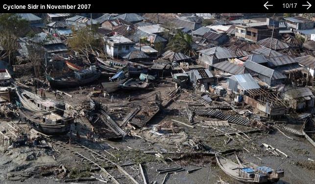
5

6 A snapshot of worst flood disasters in Bangladesh


7 Human amplified effects of tropical storms in low-lying delta settings Tidal inundated island 18 months after Cyclone Aila

 PR From TRMM to")


8 Estimating Precipitation from Space: from TRMM to GPM TRMM (1997 -) GPM (2014 -) PR From TRMM to GPM: New opportunities & new challenges in retrieval, fusion, and downscaling of precipitation 8

9 GPM: A New Era of Global Precipitation Observations GPM Core Observatory: Launched on February 27, 2014 from JAXA s Tanegashima Space Center on a Japanese H-IIA rocket


10 Spaceborne Rainfall: form TRMM to GPM DPR: 125 and 245 Km swaths Ka-band: 35.5 GHz Ku-band: 13.6 GHz GMI: 885 Km swath 13 channels GHz 10

11 Rainfall Estimation Problems Downscaling: Enhancing the resolution of a measured or modeled field Data Fusion: Produce an improved estimate of a field from a suite of noisy observations at different scales Data Assimilation: Estimate the initial conditions in a predictive model consistent with the available noisy observations and model dynamics Retrieval: Estimate rainfall from indirect noisy and lower resolution observations of brightness temperature Increasing challenges over heterogeneous surfaces and land-water interface Emphasis on preserving multi-scale features, sharp fronts, and extremes 11


12 Spatial Structure of Rainfall TRMM PR and TMI Typhoon Neoguri, Western Pacific, April, 2008,
 p(x) µ exp -l x a Generalized Gaussian Density (GGD) (α=1 Laplace)")
13 Non-Gaussian PDF in the Gradient Domain Pr. log(pr.) zeroes =0.85 Obs. Fitted Gaussian PDF of gradients >> c h Extreme gradients Gaussian c h ( ) p(x) µ exp -l x a Generalized Gaussian Density (GGD) (α=1 Laplace) Sparsity
14 Passive Microwave Retrieval: an Inverse Problem Rain Physics Radiation regime Absorption Emission Scattering Land-surf emissivity. Spectral Radiances Retrieval problem: New ideas: Preserve sharp features in estimation by choosing the proper prior Learn patterns in a smart way from the data=> key to retrieval Explore Compressive sensing methodologies to retrieve from fewer observations 14

 -- Downscaling, Fusion, Variational Data Assimilation 1. Ebtehaj A.M., G.Lerman, E Foufoula-Geogiou, JGR-A, 2012 2. Ebtehaj, A.M. and E.")
15 NEW IDEAS for GPM 1 1. Preserve unique features during estimation -- Precipitation has an intermittent and multi-variable space-time structure when projected in a derivative domain it displays sparsity Replace 80% by zeroes Wavelet Decomposition PDF of Coefficients Reconstructed image -- Sparsity requires moving away from standard Least Squares (L2) estimation paradigms and working with L1 norms (preserve a non-gaussian prior) -- Downscaling, Fusion, Variational Data Assimilation 1. Ebtehaj A.M., G.Lerman, E Foufoula-Geogiou, JGR-A, Ebtehaj, A.M. and E. Foufoula-Georgiou, WRR, Ebtehaj, A.M., M. Zupanski, G. Lerman, and E. Foufoula-Georgiou, Tellus A, Foufoula-Georgiou, E., A.M Ebtehaj, S. Zhang, A. Hou, Surveys in Geophysics,


 Manifold")
16 NEW IDEAS for GPM 2 2. Learn patterns from data for retrieval Database Spectral BT Rainfall Profiles n-dim space ShARP: Shrunken Locally Linear (each point is a Z, Embedding for Manifold learning surf R vector) Passive Retrieval Advanced estimation Manifold of R of Precipitation 9-dim space (each point is a BT vector) Manifold of BT Spectral BT x 1 x 2 x M Rainfall Profiles 16
17 CONCEPTS AND RESULTS ON RETRIEVAL 17
![Overlapping measurements of TMI and PR Rainfall and Radiometric Observations: Dictionaries [kelvin]](/docs-images/93/111217591/images/18-0.jpg "Built by 25x10 6 [kelvin] randomly chosen pixels [mm/hr] of spectral observations + rainfall 18")
18 Overlapping measurements of TMI and PR Rainfall and Radiometric Observations: Dictionaries [kelvin] Built by 25x10 6 [kelvin] randomly chosen pixels [mm/hr] of spectral observations + rainfall 18 [mm/hr]
19 ShARP: Locally linear embedding for rainfall retrieval A New Algorithm (concept): Concept of the locally linear embedding (supervised NL manifold learning): radiometer c i radar b M c i y i b k r M x c ˆ i i r k raining non-raining y n c i r n r i Search for the K-nearest neighbors to detect raining signatures Estimate the representation coefficients and thus the rainfall profile Saul and Roweis, Science,
20 ShARP: Algorithmic sketch Shrunken Locally Linear Embedding Algorithm for Precipitation Retrieval Detection step: K-nearest neighborhood search + a probabilistic voting rule for rain/no-rain Estimation Step: Estimation of the representation coefficients b k c i Rainfall estimates L1-L2 regularization for stability and reduced estimation error 20
21 ShARP methodology From: coincidental TMI, PR Obs. Spectral Radiance Dictionary: & Precipitation Dictionary: (1)Prob. of voting (2)Channel weights Detection Step: (1) Find K-nearest neighbors of y in (sub-dictionaries) (2) Determine corresponding k-nn in (3) Determine if raining/non-raining on surface Estimation Step: (1) Estimate representation coefficients of y in using a locally linear model : Important Note: (2) Estimate rainfall : 21
22 Estimation of representation coefficients in ShARP Combined L1-L2 estimation 1) Some representation coefficients are very large and some very small (shrinkage due to L1 regularization chooses the most important neighbors) 2) The L2 regularization stabilizes the inversion for efficient and stable solution 22


23 ShARP spectral weights (W) and land surfaces Spectral weights denote relative importance of each channel 23

24 TMI rain/non-rain spectral signatures A local estimation-detection model raining non-raining OCEAN LAND raining non-raining Neighborhood Euclidean distance in a multi-spectral sense 24


25 Cyclone Sidr, Nov Date: Nov. 15 at 13:59 UTC (8:59 a.m. EST)

26 Retrieval of Tropical Cyclone Sidr Radar -- 2A25-V7 NASA GPROF -- 2A12-V7 ShARP-V1

27 Retrieval of Monthly Rain, May 2013 NASA GPROF

28 Retrieval of Monthly Rain, May 2013

29 Retrieval of Monthly Rain, May 2013 Radar


30 ShARP retrieval uncertainty Hurricane Danielle (2010) Approximate the entire posterior PDF of the ShARP retrievals Probability of exceedance for the extreme rainfall for risk analysis 30


31 ShARP cumulative results Difference of the total rainfall in calendar year 2013 (1 o -degree) NASA GPROF product - true ShaRP retrieval true 31


32 ShARP cumulative results Rainfall accumulation thought January, February and March in calendar year 2013 (0.5 o -degree) NASA Passive retrieval Coastal zones NASA Active retrieval (reference) ShARP Passive retrieval 32
 advanced estimation within it (screens out irrelevant spectral candidates and reduces the effects of land surface heterogeneity in emissivity) The superiority of the")
; Zach Tessler (CUNY) Ebtehaj A.M., R. L. Bras, E.")
33 Take home message and future research GPM offers opportunities for accurate estimation of rainfall over coastal zones The proposed ShARP algorithm introduces two innovations: (1) smart selection of estimation neighborhod and (2) advanced estimation within it (screens out irrelevant spectral candidates and reduces the effects of land surface heterogeneity in emissivity) The superiority of the proposed algorithm, compared to the standard NASA retrieval algorithm especially over coastal areas, was demonstrated Perform extensive testing over delta regions and examine improvement in retrieval, early warning systems, and modeling of inundation and floods Co-authors: Mohammad Ebtehaj & Rafael Bras (Georgia Tech); Zach Tessler (CUNY) Ebtehaj A.M., R. L. Bras, E. Foufoula-Georgiou (2014), Shrunken Locally Linear Embedding Algorithm for Retrieval of Precipitation 33
Welcome and Introduction
 Welcome and Introduction Riko Oki Earth Observation Research Center (EORC) Japan Aerospace Exploration Agency (JAXA) 7th Workshop of International Precipitation Working Group 17 November 2014 Tsukuba International
APPENDIX 2 OVERVIEW OF THE GLOBAL PRECIPITATION MEASUREMENT (GPM) AND THE TROPICAL RAINFALL MEASURING MISSION (TRMM) 2-1
 AND THE TROPICAL RAINFALL MEASURING MISSION (TRMM) 2-1") APPENDIX 2 OVERVIEW OF THE GLOBAL PRECIPITATION MEASUREMENT (GPM) AND THE TROPICAL RAINFALL MEASURING MISSION (TRMM) 2-1 1. Introduction Precipitation is one of most important environmental parameters.
APPENDIX 2 OVERVIEW OF THE GLOBAL PRECIPITATION MEASUREMENT (GPM) AND THE TROPICAL RAINFALL MEASURING MISSION (TRMM) 2-1 1. Introduction Precipitation is one of most important environmental parameters.
"Cloud and Rainfall Observations using Microwave Radiometer Data and A-priori Constraints" Christian Kummerow and Fang Wang Colorado State University
 "Cloud and Rainfall Observations using Microwave Radiometer Data and A-priori Constraints" Christian Kummerow and Fang Wang Colorado State University ECMWF-JCSDA Workshop Reading, England June 16-18, 2010
Lecture 19: Operational Remote Sensing in Visible, IR, and Microwave Channels
 MET 4994 Remote Sensing: Radar and Satellite Meteorology MET 5994 Remote Sensing in Meteorology Lecture 19: Operational Remote Sensing in Visible, IR, and Microwave Channels Before you use data from any
Japanese Programs on Space and Water Applications
 Japanese Programs on Space and Water Applications Tamotsu IGARASHI Remote Sensing Technology Center of Japan June 2006 COPUOS 2006 Vienna International Centre Water-related hazards/disasters may occur
P1.23 HISTOGRAM MATCHING OF ASMR-E AND TMI BRIGHTNESS TEMPERATURES
 P1.23 HISTOGRAM MATCHING OF ASMR-E AND TMI BRIGHTNESS TEMPERATURES Thomas A. Jones* and Daniel J. Cecil Department of Atmospheric Science University of Alabama in Huntsville Huntsville, AL 1. Introduction
Global Precipitation Measurement Mission Overview & NASA Status
 Global Precipitation Measurement Mission Overview & NASA Status Gail Skofronick Jackson GPM Project Scientist (appointed 14 January 2014) Replacing Dr. Arthur Hou (1947-2013) NASA Goddard Space Flight
URSI-F Microwave Signatures Meeting 2010, Florence, Italy, October 4 8, Thomas Meissner Lucrezia Ricciardulli Frank Wentz
 URSI-F Microwave Signatures Meeting 2010, Florence, Italy, October 4 8, 2010 Wind Measurements from Active and Passive Microwave Sensors High Winds and Winds in Rain Thomas Meissner Lucrezia Ricciardulli
Pacific Storm Track at Different Horizontal Resolutions Snap-shot of Column Liquid Water Content
 Color Plates Pacific Storm Track at Different Horizontal Resolutions Snap-shot of Column Liquid Water Content Fig. 2.8 A snapshot of the cyclone frontal-system by a nonhydrostatic model run with two very
Description of Precipitation Retrieval Algorithm For ADEOS II AMSR
 Description of Precipitation Retrieval Algorithm For ADEOS II Guosheng Liu Florida State University 1. Basic Concepts of the Algorithm This algorithm is based on Liu and Curry (1992, 1996), in which the
Global Precipitation Data Sets
 Global Precipitation Data Sets Rick Lawford (with thanks to Phil Arkin, Scott Curtis, Kit Szeto, Ron Stewart, etc) April 30, 2009 Toronto Roles of global precipitation products in drought studies: 1.Understanding
Global Flood Alert System based on satellite derived rainfall data -Targeting the era of Global Precipitation Measurement (GPM)-
-") Global Flood Alert System based on satellite derived rainfall data -Targeting the era of Global Precipitation Measurement (GPM)- Riko Oki, Misako Kachi (JAXA/EORC) Kazuhiko Fukami (PWRI) and Kazuo Umeda
Global Flood Alert System based on satellite derived rainfall data -Targeting the era of Global Precipitation Measurement (GPM)- Riko Oki, Misako Kachi (JAXA/EORC) Kazuhiko Fukami (PWRI) and Kazuo Umeda
H-SAF future developments on Convective Precipitation Retrieval
 H-SAF future developments on Convective Precipitation Retrieval Francesco Zauli 1, Daniele Biron 1, Davide Melfi 1, Antonio Vocino 1, Massimiliano Sist 2, Michele De Rosa 2, Matteo Picchiani 2, De Leonibus
Impact assessment on disasters
 The 5th International Coordination Group (ICG) Meeting GEOSS Asian Water Cycle Initiative (AWCI), Dec. 16, 2009. Impact assessment on disasters Eiichi Nakakita Disaster Prevention Research Institute Kyoto
Astronaut Ellison Shoji Onizuka Memorial Downtown Los Angeles, CA. Los Angeles City Hall
 Astronaut Ellison Shoji Onizuka Memorial Downtown Los Angeles, CA Los Angeles City Hall Passive Microwave Radiometric Observations over Land The performance of physically based precipitation retrievals
GLOBAL PRECIPITATION MEASUREMENT UPDATE
 GLOBAL PRECIPITATION MEASUREMENT UPDATE Gilbert Mark Flaming National Aeronautics and Space Administration Goddard Space Flight Center Code 420.2 Greenbelt, Maryland 20771 USA Email: gilbert.m.flaming@nasa.gov
Status of the GeoKompsat-2A AMI rainfall rate algorithm
 Status of the GeoKompsat-2A AMI rainfall rate algorithm Dong-Bin Shin, Damwon So, Hyo-Jin Park Department of Atmospheric Sciences, Yonsei University Algorithm Strategy Well-known assumption in IR-based
Global Precipitation Measurement (GPM) for Science and Society
 for Science and Society") Global Precipitation Measurement (GPM) for Science and Society Gail Skofronick-Jackson GPM Project Scientist NASA Goddard Space Flight Center Radar Observation of Rain from Space Tokyo, Japan 29 November
Global Precipitation Measurement (GPM) for Science and Society Gail Skofronick-Jackson GPM Project Scientist NASA Goddard Space Flight Center Radar Observation of Rain from Space Tokyo, Japan 29 November
All-sky assimilation of MHS and HIRS sounder radiances
 All-sky assimilation of MHS and HIRS sounder radiances Alan Geer 1, Fabrizio Baordo 2, Niels Bormann 1, Stephen English 1 1 ECMWF 2 Now at Bureau of Meteorology, Australia All-sky assimilation at ECMWF
The Status of NOAA/NESDIS Precipitation Algorithms and Products
 The Status of NOAA/NESDIS Precipitation Algorithms and Products Ralph Ferraro NOAA/NESDIS College Park, MD USA S. Boukabara, E. Ebert, K. Gopalan, J. Janowiak, S. Kidder, R. Kuligowski, H. Meng, M. Sapiano,
Development of Spaceborne Dualfrequency. and Its Role for the Global Precipitation Measurement
 Development of Spaceborne Dualfrequency Precipitation Radar and Its Role for the Global Precipitation Measurement Shinsuke Satoh (1), Riko Oki (1), Nobuhiro Takahashi (2), and Toshio Iguchi (2) (1) National
Remote sensing of precipitation extremes
 The panel is about: Understanding and predicting weather and climate extreme Remote sensing of precipitation extremes Climate extreme : (JSC meeting, June 30 2014) IPCC SREX report (2012): Climate Ali
Current and Upcoming NASA Hurricane Measurement Missions National Hurricane Conference
 NASA Science Mission Directorate Earth Science Division Applied Sciences Program Current and Upcoming NASA Hurricane Measurement Missions National Hurricane Conference April 18, 2017 Formulation Implementation
State of the art of satellite rainfall estimation
 State of the art of satellite rainfall estimation 3-year comparison over South America using gauge data, and estimates from IR, TRMM radar and passive microwave Edward J. Zipser University of Utah, USA
Satellite-Based Rainfall Estimates and Their Application in Global Flood and Landslide Calculations
 Satellite-Based Rainfall Estimates and Their Application in Global Flood and Landslide Calculations Robert Adler (U. of Maryland-College Park) Huan Wu (UMD), Dalia Bach (UMD), Yang Hong (U. of OK), Hal
Overview and Access to GPCP, TRMM, and GPM Precipitation Data Products
 National Aeronautics and Space Administration ARSET Applied Remote Sensing Training http://arset.gsfc.nasa.gov @NASAARSET Overview and Access to GPCP, TRMM, and GPM Precipitation Data Products www.nasa.gov
Remote Sensing of Precipitation
 Lecture Notes Prepared by Prof. J. Francis Spring 2003 Remote Sensing of Precipitation Primary reference: Chapter 9 of KVH I. Motivation -- why do we need to measure precipitation with remote sensing instruments?
Teruyuki Nakajima Director, Earth Observation Research Center (EORC) Japan Aerospace Exploration Agency (JAXA)
 Japan Aerospace Exploration Agency (JAXA)") Tokyo Inter. Conference on the Forest Governance Initiative - Improving Forest Governance using Forest Early Warning Systems and Satellite Technologies - October 24-26, 2017 Teruyuki Nakajima Director,
Tokyo Inter. Conference on the Forest Governance Initiative - Improving Forest Governance using Forest Early Warning Systems and Satellite Technologies - October 24-26, 2017 Teruyuki Nakajima Director,
For those 5 x5 boxes that are primarily land, AE_RnGd is simply an average of AE_Rain_L2B; the ensuing discussion pertains entirely to oceanic boxes.
 AMSR-E Monthly Level-3 Rainfall Accumulations Algorithm Theoretical Basis Document Thomas T. Wilheit Department of Atmospheric Science Texas A&M University 2007 For those 5 x5 boxes that are primarily
A High-Quality Tropical Cyclone Reanalysis Dataset Using 4DVAR Data Assimilation Technique
 A High-Quality Tropical Cyclone Reanalysis Dataset Using 4DVAR Data Assimilation Technique Prof. Tim Li IPRC/University of Hawaii and Dr. Fuzhong Weng, Chief Sensor Physics Branch NOAA/NESDIS/Office of
Quantifying Global Uncertainties in a Simple Microwave Rainfall Algorithm
 JANUARY 2006 K U M M E R O W E T A L. 23 Quantifying Global Uncertainties in a Simple Microwave Rainfall Algorithm CHRISTIAN KUMMEROW, WESLEY BERG, JODY THOMAS-STAHLE, AND HIROHIKO MASUNAGA Department
Interpretation of Polar-orbiting Satellite Observations. Atmospheric Instrumentation
 Interpretation of Polar-orbiting Satellite Observations Outline Polar-Orbiting Observations: Review of Polar-Orbiting Satellite Systems Overview of Currently Active Satellites / Sensors Overview of Sensor
Rainfall estimation over the Taiwan Island from TRMM/TMI data
 P1.19 Rainfall estimation over the Taiwan Island from TRMM/TMI data Wann-Jin Chen 1, Ming-Da Tsai 1, Gin-Rong Liu 2, Jen-Chi Hu 1 and Mau-Hsing Chang 1 1 Dept. of Applied Physics, Chung Cheng Institute
GPM-GSMaP data is now available from JAXA G-portal (https://www.gportal.jaxa.jp) as well as current GSMaP web site (http://sharaku.eorc.jaxa.
 as well as current GSMaP web site (http://sharaku.eorc.jaxa.") GPM-GSMaP data is now available from JAXA G-portal (https://www.gportal.jaxa.jp) as well as current GSMaP web site (http://sharaku.eorc.jaxa.jp/ GSMaP/). GPM Core GMI TRMM PR GPM era Precipitation Radar
GPM-GSMaP data is now available from JAXA G-portal (https://www.gportal.jaxa.jp) as well as current GSMaP web site (http://sharaku.eorc.jaxa.jp/ GSMaP/). GPM Core GMI TRMM PR GPM era Precipitation Radar
NASA Flood Monitoring and Mapping Tools
 National Aeronautics and Space Administration ARSET Applied Remote Sensing Training http://arset.gsfc.nasa.gov @NASAARSET NASA Flood Monitoring and Mapping Tools www.nasa.gov Outline Overview of Flood
Improving global coastal inundation forecasting WMO Panel, UR2014, London, 2 July 2014
 Improving global coastal inundation forecasting WMO Panel, UR2014, London, 2 July 2014 Cyclone Sidr, November 2007 Hurricane Katrina, 2005 Prof. Kevin Horsburgh Head of marine physics, UK National Oceanography
11D.6 DIURNAL CYCLE OF TROPICAL DEEP CONVECTION AND ANVIL CLOUDS: GLOBAL DISTRIBUTION USING 6 YEARS OF TRMM RADAR AND IR DATA
 11D.6 DIURNAL CYCLE OF TROPICAL DEEP CONVECTION AND ANVIL CLOUDS: GLOBAL DISTRIBUTION USING 6 YEARS OF TRMM RADAR AND IR DATA 1. INTRODUCTION Before the launch of the TRMM satellite in late 1997, most
P3.4 POSSIBLE IMPROVEMENTS IN THE STANDARD ALGORITHMS FOR TRMM/PR
 P3.4 POSSIBLE IMPROVEMENTS IN THE STANDARD ALGORITHMS FOR TRMM/PR Nobuhiro Takahashi* and Toshio Iguchi National Institute of Information and Communications Technology 1. INTRODUCTION The latest version
3.7 COMPARISON OF INSTANTANEOUS TRMM SATELLITE AND GROUND VALIDATION RAIN RATE ESTIMATES
 3.7 COMPARISON OF INSTANTANEOUS TRMM SATELLITE AND GROUND VALIDATION RAIN RATE ESTIMATES David B. Wolff 1,2 Brad L. Fisher 1,2 1 NASA Goddard Space Flight Center, Greenbelt, Maryland 2 Science Systems
Assimilation of precipitation-affected radiances in a cloud-resolving. WRF ensemble data assimilation system
 Assimilation of precipitation-affected radiances in a cloud-resolving WRF ensemble data assimilation system Sara Q. Zhang 1, Milija Zupanski 2, Arthur Y. Hou 1, Xin Lin 1, and Samson H. Cheung 3 1 NASA
PRECIPITATION DOWNSCALING: METHODOLOGIES AND HYDROLOGIC APPLICATIONS
 PRECIPITATION DOWNSCALING: METHODOLOGIES AND HYDROLOGIC APPLICATIONS Efi Foufoula-Georgiou St. Anthony Falls Laboratory Dept. of Civil Engineering University of Minnesota DOWNSCALING Downscaling = Creating
The Global Precipitation Measurement (GPM) Mission: Arthur Hou. NASA Goddard Space Flight Center
 Mission: Arthur Hou. NASA Goddard Space Flight Center") The Global Precipitation Measurement (GPM) Mission: Overview and U.S. Status Arthur Hou NASA Goddard Space Flight Center 5 th IPWG Workshop 11-15 October 2010 GPM Mission Concept An international ti satellite
The Global Precipitation Measurement (GPM) Mission: Overview and U.S. Status Arthur Hou NASA Goddard Space Flight Center 5 th IPWG Workshop 11-15 October 2010 GPM Mission Concept An international ti satellite
New NASA Ocean Observations and Coastal Applications
 New NASA Ocean Observations and Coastal Applications Duane Armstrong Chief, Applied Science & Technology Project Office August 20, 2014 1 Outline NASA s new Earth Science Ocean Science Missions for 2014
Future Opportunities of Using Microwave Data from Small Satellites for Monitoring and Predicting Severe Storms
 Future Opportunities of Using Microwave Data from Small Satellites for Monitoring and Predicting Severe Storms Fuzhong Weng Environmental Model and Data Optima Inc., Laurel, MD 21 st International TOV
Generating precipitation ensembles from satellite observations: reproducing intermittency
 18 May 2016 Workshop on Stochastic Weather Generators Generating precipitation ensembles from satellite observations: reproducing intermittency Clément Guilloteau¹, Rémy Roca1, Marielle Gosset2 1 LEGOS,
JAXA s Contributions to the Climate Change Monitoring
 0 JAXA s Contributions to the Climate Change Monitoring June 7, 2011 Takao Akutsu Planning Manager Japan Aerospace Exploration Agency (JAXA) Japanese Main Activities of Earth Observation 1 GEOSS 10 years
Improving Tropical Cyclone Forecasts by Assimilating Microwave Sounder Cloud-Screened Radiances and GPM precipitation measurements
 Improving Tropical Cyclone Forecasts by Assimilating Microwave Sounder Cloud-Screened Radiances and GPM precipitation measurements Hyojin Han a, Jun Li a, Mitch Goldberg b, Pei Wang a,c, Jinlong Li a,
TRMM, Hydrologic Science, and Societal Benefit: The Role of Satellite Measurements
 TRMM, Hydrologic Science, and Societal Benefit: The Role of Satellite Measurements Michael H. Freilich TRMM 15 th Anniversary Symposium 12 November 2012 KEY TRMM ATTRIBUTES Long on-orbit lifetime 15 years
Radio Frequency Earth Science
 Radio Frequency Earth Science Overview for Committee On Radio Frequency (CORF) National Academy of Science National Research Council April 27, 2005 Bill.Watson@NASA.Gov Program Executive for Ground Networks
Satellite section P. Bauer E. Moreau J.-N. Thépaut P. Watts. Physical aspects section M. Janiskova P. Lopez J.-J. Morcrette A.
 Prospects for assimilating Cloudy radiances from AIRS Frédéric Chevallier And Satellite section P. Bauer E. Moreau J.-N. Thépaut P. Watts Physical aspects section M. Janiskova P. Lopez J.-J. Morcrette
Improving Global Analysis and Short-Range Forecast Using Rainfall and Moisture Observations Derived from TRMM and SSM/I Passive Microwave Sensors
 Improving Global Analysis and Short-Range Forecast Using Rainfall and Moisture Observations Derived from TRMM and SSM/I Passive Microwave Sensors Arthur Y. Hou,* Sara Q. Zhang,*,+ Arlindo M. da Silva,*
School on Modelling Tools and Capacity Building in Climate and Public Health April Remote Sensing
 2453-5 School on Modelling Tools and Capacity Building in Climate and Public Health 15-26 April 2013 Remote Sensing CECCATO Pietro International Research Institute for Climate and Society, IRI The Earth
Analysis of TRMM Precipitation Radar Measurements over Iraq
 International Journal of Scientific and Research Publications, Volume 6, Issue 12, December 2016 1 Analysis of TRMM Precipitation Radar Measurements over Iraq Munya F. Al-Zuhairi, Kais J. AL-Jumaily, Ali
Analyzing and Visualizing Precipitation and Soil Moisture in ArcGIS
 Analyzing and Visualizing Precipitation and Soil Moisture in ArcGIS Wenli Yang, Pham Long, Peisheng Zhao, Steve Kempler, and Jennifer Wei * NASA Goddard Earth Science Data and Information Services Center
Assessment of Precipitation Characters between Ocean and Coast area during Winter Monsoon in Taiwan
 Assessment of Precipitation Characters between Ocean and Coast area during Winter Monsoon in Taiwan Peter K.H. Wang Central Weather Bureau Abstract SSM/I has been applied in derivation of liquid water
CEOS Overview and JAXA Plans for Water Cycle Observation
 CEOS Overview and JAXA Plans for Water Cycle Observation Asian Water Cycle Symposium November 2-4, 2005 Tokyo, Japan Chu Ishida Japan Aerospace Exploration Agency (JAXA) Contents 1. CEOS overview 2. CEOS
Outline of 4 Lectures
 Outline of 4 Lectures 1. Sept. 17, 2008: TC best track definition and datasets, global distribution of TCs; Review of history of meteorological satellites, introducing different orbits, scanning patterns,
Significant cyclone activity occurs in the Mediterranean
 TRMM and Lightning Observations of a Low-Pressure System over the Eastern Mediterranean BY K. LAGOUVARDOS AND V. KOTRONI Significant cyclone activity occurs in the Mediterranean area, mainly during the
GCOM-W1 now on the A-Train
 GCOM-W1 now on the A-Train GCOM-W1 Global Change Observation Mission-Water Taikan Oki, K. Imaoka, and M. Kachi JAXA/EORC (& IIS/The University of Tokyo) Mini-Workshop on A-Train Science, March 8 th, 2013
Model errors in tropical cloud and precipitation revealed by the assimilation of MW imagery
 Model errors in tropical cloud and precipitation revealed by the assimilation of MW imagery Katrin Lonitz, Alan Geer, Philippe Lopez + many other colleagues 20 November 2014 Katrin Lonitz ( ) Tropical
An analysis of storm surge attenuation by wetlands using USGS, FEMA, and NASA data
 An analysis of storm surge attenuation by wetlands using USGS, FEMA, and NASA data Pat Fitzpatrick Geosystems Research Institute Mississippi State University Walter Peterson and Courtney Buckley NASA Marshall
A Prototype Precipitation Retrieval Algorithm Over Land for SSMIS and ATMS
 A Prototype Precipitation Retrieval Algorithm Over Land for SSMIS and ATMS Yalei You 1, Nai-Yu Wang 2, Ralph Ferraro 2 1 CICS-MD/ESSIC/UMD 2 STAR/NESDIS/NOAA Background Our group provided the level-2 rainfall
ECMWF. ECMWF Land Surface Analysis: Current status and developments. P. de Rosnay M. Drusch, K. Scipal, D. Vasiljevic G. Balsamo, J.
 Land Surface Analysis: Current status and developments P. de Rosnay M. Drusch, K. Scipal, D. Vasiljevic G. Balsamo, J. Muñoz Sabater 2 nd Workshop on Remote Sensing and Modeling of Surface Properties,
The Effects of Rainfall Inhomogeneity on Climate Variability of Rainfall Estimated from Passive Microwave Sensors
 624 JOURNAL OF ATMOSPHERIC AND OCEANIC TECHNOLOGY VOLUME 21 The Effects of Rainfall Inhomogeneity on Climate Variability of Rainfall Estimated from Passive Microwave Sensors CHRISTIAN KUMMEROW Department
Characteristics of Precipitation Systems over Iraq Observed by TRMM Radar
 American Journal of Engineering Research (AJER) e-issn: 2320-0847 p-issn : 2320-0936 Volume-5, Issue-11, pp-76-81 www.ajer.org Research Paper Open Access Characteristics of Precipitation Systems over Iraq
P6.13 GLOBAL AND MONTHLY DIURNAL PRECIPITATION STATISTICS BASED ON PASSIVE MICROWAVE OBSERVATIONS FROM AMSU
 P6.13 GLOBAL AND MONTHLY DIURNAL PRECIPITATION STATISTICS BASED ON PASSIVE MICROWAVE OBSERVATIONS FROM AMSU Frederick W. Chen*, David H. Staelin, and Chinnawat Surussavadee Massachusetts Institute of Technology,
Remote Sensing in Meteorology: Satellites and Radar. AT 351 Lab 10 April 2, Remote Sensing
 Remote Sensing in Meteorology: Satellites and Radar AT 351 Lab 10 April 2, 2008 Remote Sensing Remote sensing is gathering information about something without being in physical contact with it typically
Characteristics of Global Precipitable Water Revealed by COSMIC Measurements
 Characteristics of Global Precipitable Water Revealed by COSMIC Measurements Ching-Yuang Huang 1,2, Wen-Hsin Teng 1, Shu-Peng Ho 3, Ying-Hwa Kuo 3, and Xin-Jia Zhou 3 1 Department of Atmospheric Sciences,
ECMWF. Potential of the SSM/I rain observations for the 4D-Var assimilation. F. Chevallier, P. Bauer, E. Moreau, J.-F. Mahfouf
 Potential of the SSM/I rain observations for the 4D-Var assimilation F. Chevallier, P. Bauer, E. Moreau, J.-F. Mahfouf European Centre for Medium-Range Weather Forecasts Reading, U.K. ECMWF Introduction
Severe storms over the Mediterranean Sea: A satellite and model analysis
 National Research Council of Italy Severe storms over the Mediterranean Sea: A satellite and model analysis V. Levizzani, S. Laviola, A. Malvaldi, M. M. Miglietta, and E. Cattani 6 th International Precipitation
Direct assimilation of all-sky microwave radiances at ECMWF
 Direct assimilation of all-sky microwave radiances at ECMWF Peter Bauer, Alan Geer, Philippe Lopez, Deborah Salmond European Centre for Medium-Range Weather Forecasts Reading, Berkshire, UK Slide 1 17
THE STATUS OF THE NOAA/NESDIS OPERATIONAL AMSU PRECIPITATION ALGORITHM
 THE STATUS OF THE NOAA/NESDIS OPERATIONAL AMSU PRECIPITATION ALGORITHM R.R. Ferraro NOAA/NESDIS Cooperative Institute for Climate Studies (CICS)/ESSIC 2207 Computer and Space Sciences Building Univerisity
Rain rate retrieval using the 183-WSL algorithm
 Rain rate retrieval using the 183-WSL algorithm S. Laviola, and V. Levizzani Institute of Atmospheric Sciences and Climate, National Research Council Bologna, Italy (s.laviola@isac.cnr.it) ABSTRACT High
Spaceborne and Ground-based Global and Regional Precipitation Estimation: Multi-Sensor Synergy
 Hydrometeorology and Remote Sensing Lab (hydro.ou.edu) at The University of Oklahoma Spaceborne and Ground-based Global and Regional Precipitation Estimation: Multi-Sensor Synergy Presented by: 温逸馨 (Berry)
Convective scheme and resolution impacts on seasonal precipitation forecasts
 GEOPHYSICAL RESEARCH LETTERS, VOL. 30, NO. 20, 2078, doi:10.1029/2003gl018297, 2003 Convective scheme and resolution impacts on seasonal precipitation forecasts D. W. Shin, T. E. LaRow, and S. Cocke Center
A Time Lag Model to Estimate Rainfall Rate Based on GOES Data
 A Time Lag Model to Estimate Rainfall Rate Based on GOES Data Nazario D. Ramirez, Robert J. Kuligowski, and Joan M. Castro Octava Reunión Nacional de Percepción Remota y Sistemas Geográficos de Información
SMAP Winds. Hurricane Irma Sep 5, AMS 33rd Conference on Hurricanes and Tropical Meteorology Ponte Vedra, Florida, 4/16 4/20, 2018
 Intensity and Size of Strong Tropical Cyclones in 2017 from NASA's SMAP L-Band Radiometer Thomas Meissner, Lucrezia Ricciardulli, Frank Wentz, Remote Sensing Systems, Santa Rosa, USA Charles Sampson, Naval
A two-season impact study of the Navy s WindSat surface wind retrievals in the NCEP global data assimilation system
 A two-season impact study of the Navy s WindSat surface wind retrievals in the NCEP global data assimilation system Li Bi James Jung John Le Marshall 16 April 2008 Outline WindSat overview and working
Eight Years of TRMM Data: Understanding Regional Mechanisms Behind the Diurnal Cycle
 Eight Years of TRMM Data: Understanding Regional Mechanisms Behind the Diurnal Cycle Steve Nesbitt, Rob Cifelli, Steve Rutledge Colorado State University Chuntao Liu, Ed Zipser University of Utah Funding
GLOBAL PRECIPITATION MEASUREMENT (GPM) MISSION. Algorithm Theoretical Basis Document. GPROF2017 Version 1 (used in GPM V5 processing) June 1 st, 2017
 MISSION. Algorithm Theoretical Basis Document. GPROF2017 Version 1 (used in GPM V5 processing) June 1 st, 2017") GLOBAL PRECIPITATION MEASUREMENT (GPM) MISSION Algorithm Theoretical Basis Document GPROF2017 Version 1 (used in GPM V5 processing) June 1 st, 2017 Passive Microwave Algorithm Team Facility TABLE OF CONTENTS
GLOBAL PRECIPITATION MEASUREMENT (GPM) MISSION Algorithm Theoretical Basis Document GPROF2017 Version 1 (used in GPM V5 processing) June 1 st, 2017 Passive Microwave Algorithm Team Facility TABLE OF CONTENTS
Contribution to global Earth observation from satellites
 Contribution to global Earth observation from satellites - JAXA s Earth Observation strategy - April 16, 2008 Makoto Kajii Japan Aerospace Exploration Agency Earth Observation Summits and GEOSS 1 st EO
High resolution spatiotemporal distribution of rainfall seasonality and extreme events based on a 12-year TRMM time series
 High resolution spatiotemporal distribution of rainfall seasonality and extreme events based on a 12-year TRMM time series Bodo Bookhagen, Geography Department, UC Santa Barbara, Santa Barbara, CA 93106-4060
GPM/DPR V5 algorithm. Toshio Iguchi NICT JPST teleference 13 April 2017
 GPM/DPR V5 algorithm Toshio Iguchi NICT JPST teleference 13 April 2017 Major changes that affect R estimates in V5 Calibration change in L1 (Positive effect) Zm increases from V4 by KuPR: +1.3 db, KaPR(MS):
Comparison between TRMM-TMI microwave land surface emissivity maps derived from JRA-25 and ERA-Interim
 Comparison between TRMM-TMI microwave land surface emissivity maps derived from JRA-25 and ERA-Interim Fumie Akimoto Furuzawa Hirohiko Masunaga (ISEE*, Nagoya University) *HyARC was changed to Institute
Global Climate Change and Human Health Cycloning out of Control: Climate Change Impacts on Natural Disasters; Cyclones
 INSTRUCTOR BACKGROUND Cyclones are one of the world s most devastating natural disasters causing billions of dollars in damages to homes, building and infrastructure annually. The United Nations estimates
Status of Indian Satellite Meteorological Programme
 Status of Indian Satellite Meteorological Programme Pradeep K Thapliyal Space Applications Centre (SAC) Indian Space research Organisation (ISRO) Ahmedabad (INDIA) Email: pkthapliyal@sac.isro.gov.in International
Toward a Fully Parametric Retrieval of the Nonraining Parameters over the Global Oceans
 JUNE 2008 E L S A E S S E R A N D K U M M E R O W 1599 Toward a Fully Parametric Retrieval of the Nonraining Parameters over the Global Oceans GREGORY S. ELSAESSER AND CHRISTIAN D. KUMMEROW Department
Lecture 4b: Meteorological Satellites and Instruments. Acknowledgement: Dr. S. Kidder at Colorado State Univ.
 Lecture 4b: Meteorological Satellites and Instruments Acknowledgement: Dr. S. Kidder at Colorado State Univ. US Geostationary satellites - GOES (Geostationary Operational Environmental Satellites) US
EFFECTIVE TROPICAL CYCLONE WARNING IN BANGLADESH
 Country Report of Bangladesh On EFFECTIVE TROPICAL CYCLONE WARNING IN BANGLADESH Presented At JMA/WMO WORKSHOP ON EFFECTIVE TROPICAL CYCLONE WARNING IN SOUTHEAST ASIA Tokyo, Japan,11-14 March 2014 By Sayeed
Department of Earth and Environment, Florida International University, Miami, Florida
 DECEMBER 2013 Z A G R O D N I K A N D J I A N G 2809 Investigation of PR and TMI Version 6 and Version 7 Rainfall Algorithms in Landfalling Tropical Cyclones Relative to the NEXRAD Stage-IV Multisensor
Satellite Remote Sensing for Ocean
 Satellite Remote Sensing for Ocean August 17, 2017 Masatoshi Kamei RESTEC All rights reserved RESTEC 2015 Contents 1. About RESTEC and Remote Sensing 2. Example of Remote Sensing Technology 3. Remote Sensing
Passive and Active Microwave Sensors for Precipitation Research
 Passive and Active Microwave Sensors for Precipitation Research Joe Turk Jet Propulsion Laboratory California Institute of Technology Pasadena, CA jturk@jpl.nasa.gov Characteristics of Precipitation Wide
Rainfall Observation from Space: A overview of GPM and GSMaP
 Rainfall Observation from Space: A overview of GPM and GSMaP (July 2016 version) Earth Observation Research Center (EORC) Japan Aerospace Exploration Agency (JAXA) Rainfall Measurement and our life Rain
 Page 1 of 5 Home research global climate enso effects Research Effects of El Niño on world weather Precipitation Temperature Tropical Cyclones El Niño affects the weather in large parts of the world. The
Assimilation of precipitation-related observations into global NWP models
 Assimilation of precipitation-related observations into global NWP models Alan Geer, Katrin Lonitz, Philippe Lopez, Fabrizio Baordo, Niels Bormann, Peter Lean, Stephen English Slide 1 H-SAF workshop 4
Using HIRS Observations to Construct Long-Term Global Temperature and Water Vapor Profile Time Series
 Using HIRS Observations to Construct Long-Term Global Temperature and Water Vapor Profile Time Series Lei Shi and John J. Bates National Climatic Data Center, National Oceanic and Atmospheric Administration
PUBLICATIONS. Journal of Geophysical Research: Atmospheres. Rain detection and measurement from Megha-Tropiques microwave sounder SAPHIR
 PUBLICATIONS Journal of Geophysical Research: Atmospheres RESEARCH ARTICLE Key Points: Rain retrieval from Megha-Tropiques SAPHIR microwave sounder Separate algorithms are developed for identification
Daniel J. Cecil 1 Mariana O. Felix 1 Clay B. Blankenship 2. University of Alabama - Huntsville. University Space Research Alliance
 12A.4 SEVERE STORM ENVIRONMENTS ON DIFFERENT CONTINENTS Daniel J. Cecil 1 Mariana O. Felix 1 Clay B. Blankenship 2 1 University of Alabama - Huntsville 2 University Space Research Alliance 1. INTRODUCTION
Study on data assimilation to improve precipitation forecasts
 Study on data assimilation to improve precipitation forecasts CI: Kozo Okamoto*, Kazumasa Aonashi, Seiji Origuchi, Toshiyuki Ishibashi (/MRI) Thanks to Takuji Kubota (JAXA), Akihiro Hahimoto (MRI) 14-17
P r o c e. d i n g s. 1st Workshop. Madrid, Spain September 2002
 P r o c e e d i n g s 1st Workshop Madrid, Spain 23-27 September 2002 SYNERGETIC USE OF TRMM S TMI AND PR DATA FOR AN IMPROVED ESTIMATE OF INSTANTANEOUS RAIN RATES OVER AFRICA Jörg Schulz 1, Peter Bauer