EFFECTIVE TROPICAL CYCLONE WARNING IN BANGLADESH
|
|
|
- Camron Parker
- 5 years ago
- Views:
Transcription


1 Country Report of Bangladesh On EFFECTIVE TROPICAL CYCLONE WARNING IN BANGLADESH Presented At JMA/WMO WORKSHOP ON EFFECTIVE TROPICAL CYCLONE WARNING IN SOUTHEAST ASIA Tokyo, Japan,11-14 March 2014 By Sayeed Ahmed Choudhury Meteorologist Bangladesh Meteorological Department
2 Introduction Bangladesh is situated at the northern tip of the Bay of Bengal. Long continental shelf, shallow bathymetry, complex coastal Geometry with many kinks and islands, and long tidal range between east and west coasts of Bangladesh are well-known features for the highest storm surge and of the longest duration. About 5% of the global tropical cyclones form over the Bay of Bengal (Fig.1). On an average, 5 to 6 storms form in this region every year. But casualties, here, is 80% of the global casualties. Loss of life and property is mainly attributed to the storm surge.
3 Introduction continued. The Bay of Bengal is surrounded by the coastal region of Bangladesh and Myanmar. India, Northern part of the Bay of Bengal is generally known as Head Bay to meteorologists, stands within 18.0 N to 23.0 N latitude and 83.5 E to 94.5 E longitude and surrounded by Orissa and West Bengal coast of India in the west, coastal areas of Bangladesh in the north and Myanmar coast in the southeast. The coastal geometry and bathymetric condition of Head Bay is very complex. The Lion numbers of cyclones formed in the Bay of Bengal initially move towards the west or northwest and recurved towards right due to the effect of the Coriolis force.

4 When they moved further north towards Bangladesh coast where bathymetric depth is shallow the height of the storm surge become higher and higher. When they made landfall in the coast, they produce devastating impacts over the coastal areas of Bangladesh.

5 Bangladesh Bay Of Bengal

6 How to Issue Warnings Charts Satellite Data RADAR NWP Products Other Information Forecaster Warnings

7 Observational Facilities of BMD Synoptic observatories : 35 Pilot Observatories : 10 Rawinsonde Observatories: 3 Agromet observatories : 12 RADAR Stations : 5 (3 is Doppler Radar)
8 Effect of local Tides Effect of local Coastal Configuration Low Atmospheric Pressure in the Centre Storm Surge Flooding of Low- Lying Coastal Areas Erosion of Beaches Damage to onshore & offshore installations Damage to Shipping & Fishing Facilities Loss of Soil Fertility from Saline Intrusion Land Subsidence Contamination of domestic Water Supply Wind Loss of Human Life: Injuries Damage to structures & Continent Urban Bushfire Destruction of Vegetation, Crops, Livestock Loss of Communications & Power Rain Flooding Potential Impact upon Landfall of a Tropical Cyclone

9 Warning Dissemination Mechanisms
10 Some of the devastating cyclones that hit Bangladesh coast are: Date People killed Storm surge height 12 Nov. 1970, cyclone 3,00, m 29 April 1991, cyclone 1,38, m 19 May 1997, cyclone m 15 Nov. 2007, cyclone 3, m


11 Storm surge due to cyclone Aila 2009 Simulated surge for cyclonic storm Maximum value of peak surge = 2.53 m. Track of cyclonic storm From Unisys site.


12 Storm surge due to cyclone Sidr 2007 Simulated surge for cyclonic storm Maximum value of peak surge = 5.56 m. Track of cyclonic storm (From Unisys site)


13 Storm surge due to Cyclone 1991 Simulated surge for cyclonic storm Apr. 1991, Maximum value of peak surge = 7.05 m Track of cyclonic storm April 1991 (From Unisys site).


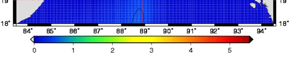
14 Storm surge due to cyclone Sidr 2007


15 Storm Surge Storm surge is an offshore rise of water associated with tropical cyclone over the low-lying coastal areas.


16 Storm Surge in shallow continental shelf Storm Surge in steep continental shelf


17 Impact of Storm surge
18 Causes of high storm surge over the coastal region of Bangladesh The main causes for the devastating storm surge along the coastal region of Bangladesh are: Funnel shape of the Bay, Shallow bathymetry Long continental shelf, High astronomical tide and Long tidal range between east coast and west coast, Low lying island and chars, Favourable cyclone track, Innumerable number of inlets including worlds largest river system (Ganga-Brahmaputra-Meghna).
19 Requirement of EWS for TC Almost all the loss of lives and most of the damage from a tropical cyclone are due to the storm surge. The real time monitoring, forecasting and warning of tropical cyclone helps to reduce the loss of lives and damage of properties. This needs the address of effective storm surge modeling and forecasting. Bangladesh Meteorological department is responsible for prediction of storm surge associated with cyclone along the coastal region of Bangladesh. To address this issue BMD keeps provision of tropical cyclone prediction in the Special Weather Bulletin in a separate paragraph.

20 Bangladesh Meteorological Department Meteorological Complex Agargaon, Dhaka-1207, Bangladesh. TEL , FAX ,
COUNTRY PRESENTATION ON MR JAYNAL ABEDIN JOINT SECRETARY ( WORKS & DEVELOPMENT ) MINISTRY OF DEFENCE
 MINISTRY OF DEFENCE") COUNTRY PRESENTATION ON By MR JAYNAL ABEDIN JOINT SECRETARY ( WORKS & DEVELOPMENT ) MINISTRY OF DEFENCE Bangladesh Geographical Location of Bangladesh Bangladesh Country at a Glance Physical Features 1,230
COUNTRY PRESENTATION ON By MR JAYNAL ABEDIN JOINT SECRETARY ( WORKS & DEVELOPMENT ) MINISTRY OF DEFENCE Bangladesh Geographical Location of Bangladesh Bangladesh Country at a Glance Physical Features 1,230
Country Report of Bangladesh On
 Country Report of Bangladesh On EFFECTIVE TROPICAL CYCLONE WARNING IN BANGLADESH Presented At JMA/WMO WORKSHOP ON EFFECTIVE TROPICAL CYCLONE WARNING IN SOUTHEAST ASIA Tokyo, Japan 11-14 March 2014 By Sayeed
International Journal of Integrated Sciences & Technology 2 (2016) 55-61
 55-61") International Journal of Integrated Sciences & Technology 2 (2016) 55-61 Changes in Latent Heat Energy and Moist Static Energy Contents of the Atmosphere over Bangladesh and Neighbourhood during the Formation
International Journal of Integrated Sciences & Technology 2 (2016) 55-61 Changes in Latent Heat Energy and Moist Static Energy Contents of the Atmosphere over Bangladesh and Neighbourhood during the Formation
Coastal Inundation Forecasting and Community Response in Bangladesh
 WMO Coastal Inundation Forecasting and Community Response in Bangladesh Bapon (SHM) Fakhruddin Nadao Kohno 12 November 2015 System Design for Coastal Inundation Forecasting CIFDP-PSG-5, 14-16 May 2014,
Vulnerability of Bangladesh to Cyclones in a Changing Climate
 Vulnerability of Bangladesh to Cyclones in a Changing Climate Susmita Dasgupta Kiran Pandey Mainul Huq Zahirul Huq Khan M.M. Zahid Ahmed Nandan Mukherjee Malik Fida Khan 2010 Bangladesh: Tropical Cyclone
Forcing ocean model with atmospheric model outputs to simulate storm surge in the Bangladesh coast
 Forcing ocean model with atmospheric model outputs to simulate storm surge in the Bangladesh coast Nabir Mamnun 1, 2, Lucy Brechino 3, Md. Rashed-Un-Nabi 2 1. Nansen-Bangladesh International Centre for
Chapter 24 Tropical Cyclones
 Chapter 24 Tropical Cyclones Tropical Weather Systems Tropical disturbance a cluster of thunderstorms about 250 to 600 km in diameter, originating in the tropics or sub-tropics Tropical depression a cluster
Management in Surface, Climate and Upper-air Observations in RAII,Tokyo, Assistant Director Bangladesh Meteorological Department
 JMA / WMO Workshop on Quality Management in Surface, Climate and Upper-air Observations in RAII,Tokyo, 27-30 July 2010 Shamsuddin Ahmed Assistant Director Bangladesh Meteorological Department Bangladesh
Country Report: Bangladesh
 The 5th International Coordination Group (ICG) Meeting GEOSS Asian Water Cycle Initiative (AWCI) Tokyo, Japan, 15-18, December 2009 Country Report: Bangladesh Monitoring and forecasting of cyclones SIDR
Saiful Islam Anisul Haque
 Workshop on Disaster Prevention/Mitigation Measures against Floods and Storm Surges in Bangladesh on 17-21 November, 2012, in Kyoto University, Japan Component 2: Flood disaster risk assessment and mitigation
Improving global coastal inundation forecasting WMO Panel, UR2014, London, 2 July 2014
 Improving global coastal inundation forecasting WMO Panel, UR2014, London, 2 July 2014 Cyclone Sidr, November 2007 Hurricane Katrina, 2005 Prof. Kevin Horsburgh Head of marine physics, UK National Oceanography
Synoptic situations of severe local convective storms during the pre-monsoon season in Bangladesh
 INTERNATIONAL JOURNAL OF CLIMATOLOGY Int. J. Climatol. 33: 725 734 (2013) Published online 13 March 2012 in Wiley Online Library (wileyonlinelibrary.com) DOI: 10.1002/joc.3460 Synoptic situations of severe
DR RAJENDRA KUMAR JENAMANI
 TCAC NEW DELHI METHODS AND PROCEDURES USED FOR PREDICTION DR RAJENDRA KUMAR JENAMANI Director In-Charge Meteorological Watch Office (MWO) INDIA METEOROLOGICAL DEPARTMENT New ATS Building (Room No.-211,
National Report on Weather Forecasting Service
 MINISTRY OF WATER RESOURCES AND METEOROLOGY DEPARTMENT OF METEOROLOGY, CAMBODIA National Report on Weather Forecasting Service Tokyo, 11-15 March 2014 Department of Meteorology, Cambodia Presentation Outline
A TRANSFORMED COORDINATE MODEL TO PREDICT TIDE AND SURGE ALONG THE HEAD BAY OF BENGAL- APPLICATION TO CYCLONE OF 1991 AND 1970
 GANIT J. Bangladesh Math. Soc. (ISSN 1606-3694) 35 (015) 7-5 A TRANSFORMED COORDINATE MODEL TO PREDICT TIDE AND SURGE ALONG THE HEAD BAY OF BENGAL- APPLICATION TO CYCLONE OF 1991 AND 1970 Farzana Hussain
Homework 8: Hurricane Damage (adapted from Pipkin et al.)
") 1 Homework 8: Hurricane Damage (adapted from Pipkin et al.) Tropical cyclones have a significant impact on coastal areas of the world. In the Atlantic and Eastern Pacific Oceans they are called hurricanes
1 Homework 8: Hurricane Damage (adapted from Pipkin et al.) Tropical cyclones have a significant impact on coastal areas of the world. In the Atlantic and Eastern Pacific Oceans they are called hurricanes
South, Southeast, and East Asia. Physical Geography
 South, Southeast, and East Asia Physical Geography Mountains v Mountains are important in Asia because they influence: A. Population patterns B. Movement of people and goods C. Climate Mountains v The
Major Hurricane Matthew Briefing Situation Overview
 Major Hurricane Matthew Briefing Situation Overview THIS IS NOW A WORST CASE STORM SURGE SCENARIO Catastrophic Damage is Anticipated for Coastal Areas. Major Hurricane Matthew is still expected to move
Modelling coastal flood risk in the data poor Bay of Bengal region
 Modelling coastal flood risk in the data poor Bay of Bengal region Matt Lewis*, Kevin Horsburgh (NOC), Paul Bates (Bristol) *m.j.lewis@bangor.ac.uk Funded by the EPSRC Flood Risk Management Research Consortium
Cyclone forecasting and its constrains for the Bay of Bengal
 Annex IV JMA/WMO WORKSHOP ON EFFECTIVE TROPICAL CYCLONE WARNING IN SOUTHEAST ASIA Tokyo, Japan 11-14 March 2014 Cyclone forecasting and its constrains for the Bay of Bengal Submitted by Kawsar Parvin Meteorologist
COASTAL VULNERABILITY DUE TO SEA-LEVEL RISE HAZARDS IN THE BANGLADESH DELTA: BAND-AID
 Band-Aid Project NASA NASA ESA ESA JAXA NASA/DLR COASTAL VULNERABILITY DUE TO SEA-LEVEL RISE HAZARDS IN THE BANGLADESH DELTA: BAND-AID R. Rietbroek, B. Uebbing, C.K. Shum, V. Ballu, S. Calmant, J. Duan,
DBCP 2012 SCIENTIFIC AND TECHNICAL WORKSHOP Fremantle, Australia, 2 October 2012 SALIENT FEATURES OF INDIAN DEEP SEA INSTRUMENTED BUOY NETWORK IN THE
 DBCP 2012 SCIENTIFIC AND TECHNICAL WORKSHOP Fremantle, Australia, 2 October 2012 SALIENT FEATURES OF INDIAN DEEP SEA INSTRUMENTED BUOY NETWORK IN THE BAY OF BENGAL R. Venkatesan, Arul Muthiah, Simi Mathew
CYCLONE LAILA RED WARNING. May 19, 2010 (23.45 hrs)
") CYCLONE LAILA RED WARNING May 19, 2010 (23.45 hrs) The severe cyclonic storm LAILA over westcentral and adjoining southwest Bay of Bengal remained practically stationary and lay centred at 2030 hrs IST
CYCLONE LAILA RED WARNING May 19, 2010 (23.45 hrs) The severe cyclonic storm LAILA over westcentral and adjoining southwest Bay of Bengal remained practically stationary and lay centred at 2030 hrs IST
ESCI 241 Meteorology Lesson 19 Tropical Cyclones Dr. DeCaria
 ESCI 241 Meteorology Lesson 19 Tropical Cyclones Dr. DeCaria READING: Chapter 16 GENERAL A tropical cyclone is a large, low-pressure system that forms over the tropical oceans. Tropical cyclones are classified
Tropics: Weather Forecasting And Early Warning System in Bangladesh.
 Regional Workshop on Impact-based Forecast in RA II (Asia) 07-09,November 2017 Seoul, Republic of Korea. Tropics: Weather Forecasting And Early Warning System in Bangladesh. Md. Sanaul Hoque Mondal Assistant
Earth Observation & forecasting Storm Surges in the North Western Pacific. Mr. Nadao Kohno Japan Meteorological Agency
 Earth Observation & forecasting Storm Surges in the North Western Pacific Mr. Nadao Kohno Japan Meteorological Agency Lesson Outline Introduction JMA s responsibility and work as a RSMC, Tokyo Typhoon
Impact of Coastal Flooding on Land use Pattern Considering Climate Change
 Impact of Coastal Flooding on Land use Pattern Considering Climate Change Pronab Kumar Halder Institute of Water and Flood Management (IWFM), Bangladesh University of Engineering and Technology (BUET),pronab.halder@gmail.com
Assessing Storm Tide Hazard for the North-West Coast of Australia using an Integrated High-Resolution Model System
 Assessing Storm Tide Hazard for the North-West Coast of Australia using an Integrated High-Resolution Model System J. Churchill, D. Taylor, J. Burston, J. Dent September 14, 2017, Presenter Jim Churchill
2014/2/25. Earth Observation & forecasting Storm Surges in the North Western Pacific. Lesson Outline. RSMC Tokyo Typhoon Center.
 Earth Observation & forecasting Storm Surges in the North Western Pacific Mr. Nadao Kohno Japan Meteorological Agency Lesson Outline Introduction JMA s responsibility and work as a RSMC, Tokyo Typhoon
Bistandsprosjekter i Sørøst-Asia
 Bistandsprosjekter i Sørøst-Asia -Sikre liv og verdier Lars R. Hole, Hanneke Luijting, Tor Ivar Mathisen og Kristine Gjesdal September 2017 Norwegian Meteorological Institute Background Ministry of Foreign
11/19/14. Chapter 11: Hurricanes. The Atmosphere: An Introduction to Meteorology, 12 th. Lutgens Tarbuck
 Chapter 11: Hurricanes The Atmosphere: An Introduction to Meteorology, 12 th Lutgens Tarbuck Lectures by: Heather Gallacher, Cleveland State University! Hurricanes: " Hurricanes are intense centers of
Caribbean Early Warning System Workshop
 Caribbean Early Warning System Workshop Hamonization in Existing EWS April 14-16, 2016 Presenter: Shawn Boyce Caribbean Institute for Meteorology and Hydrology Husbands, St. James Barbados Background Between
Government of Sultanate of Oman Public Authority of Civil Aviation Directorate General of Meteorology. National Report To
 Government of Sultanate of Oman Public Authority of Civil Aviation Directorate General of Meteorology National Report To Panel on Tropical Cyclones in the Bay of Bengal And Arabian Sea 43rd Session, India
Monitoring Cyclone Sidr plight over the largest river delta of the world
 Monitoring Cyclone Sidr plight over the largest river delta of the world On November 15, 2007 the horrible category 4 Cyclone Sidr attacked Bangladesh leaving lots of casualty and damages. Landfall of
Indian Ocean Forecast System (INDOFOS) Abhisek Chatterjee
 Abhisek Chatterjee") Indian Ocean Forecast System (INDOFOS) Abhisek Chatterjee Earth System Sciences Organisation (ESSO) Indian National Centre for Ocean Information Services (INCOIS) Ministry of Earth Sciences, Government
Indian Ocean Forecast System (INDOFOS) Abhisek Chatterjee Earth System Sciences Organisation (ESSO) Indian National Centre for Ocean Information Services (INCOIS) Ministry of Earth Sciences, Government
PAGASA s Expectations of New-generation Satellites for Hazard Monitoring
 Country Report Philippines PAGASA s Expectations of New-generation Satellites for Hazard Monitoring VICENTE P. PALCON, JR. (Assistant Weather Services Chief) Weather Division- PAGASA DOST Email: vppalconjr@pagasa.dost.gov.ph
2) What general circulation wind belt is the place of origin for hurricanes? A) westerlies B) trade winds C) doldrums D) horse latitudes
 What general circulation wind belt is the place of origin for hurricanes? A) westerlies B) trade winds C) doldrums D) horse latitudes") Meteo 1010 Homework 6 1) What is the difference between a typhoon and a hurricane? A) A hurricane is a true tropical cyclone, but a typhoon is not. B) A hurricane is stronger than a typhoon. C) They represent
Meteo 1010 Homework 6 1) What is the difference between a typhoon and a hurricane? A) A hurricane is a true tropical cyclone, but a typhoon is not. B) A hurricane is stronger than a typhoon. C) They represent
Weather Forecasting in Flood Forecasting Activities
 Weather Forecasting in Flood Forecasting Activities Eugene Poolman South African Weather Service Representing CBS Pretoria South Africa FCAST PRES 20130919 001 Main Activities of CBS Development, implementation
Chapter 16, Part Hurricane Paths. 2. Hurricane Paths. Hurricane Paths and Damage
 Chapter 16, Part 2 Hurricane Paths and Damage 1. Hurricane Paths Start over tropical water except South Atlantic and eastern South Atlantic, where water is too cold. Initially steered by easterly winds
5 Simulation of storm surges in the Bay of Bengal
 Chapter 5 5 Simulation of storm surges in the Bay of Bengal 5.1 Introduction As a first step towards increasing the accuracy of storm surge simulation, a 2D model was developed to simulate the tides in
CASE STUDY: Tropical Cyclone Monica, April 2006
 CASE STUDY: Tropical Cyclone Monica, April 2006 By Mr Jeff Callaghan Retired Senior Severe Weather Forecaster, Bureau of Meteorology, Brisbane The track of tropical cyclone Monica (Figure 1) took it from
5 Atmospheric Disturbances 7 1.Cyclones- tropical and temperate and associated weather conditions. 2.Anticyclones and associated weather conditions.
 5 Atmospheric Disturbances 7 1.Cyclones- tropical and temperate and associated weather conditions. 2.Anticyclones and associated weather conditions. atmospheric disturbances (weather systems) that are
UPDATE OF REGIONAL WEATHER AND SMOKE HAZE (December 2017)
") UPDATE OF REGIONAL WEATHER AND SMOKE HAZE (December 2017) 1. Review of Regional Weather Conditions for November 2017 1.1 In November 2017, Southeast Asia experienced inter-monsoon conditions in the first
UPDATE OF REGIONAL WEATHER AND SMOKE HAZE (December 2017) 1. Review of Regional Weather Conditions for November 2017 1.1 In November 2017, Southeast Asia experienced inter-monsoon conditions in the first
Experimental storm surge forecasting in the Bay of Bengal
 Environmental Problems in Coastal Regions VI 397 Experimental storm surge forecasting in the Bay of Bengal H. S. Mashriqui 1, G. P. Kemp 1, I. van Heerden 1, J. Westerink 2, Y. S. Yang 1 & B. D. Ropers-Huilman
UNIT 11 SOUTH ASIA SG 1 - PHYSICAL GEOGRAPHY & THE ENVIRONMENT
 UNIT 11 SOUTH ASIA SG 1 - PHYSICAL GEOGRAPHY & THE ENVIRONMENT I. PHYSICAL GEOGRAPHY TAKE OUT YOUR PHYSICAL MAP OF SOUTH ASIA A. The Himalayan Mountains form the northern boundary of the region (color
Joint Meeting of RA II WIGOS Project and RA V TT-SU on 11 October 2018 BMKG Headquarter Jakarta, Indonesia. Mrs. Sinthaly CHANTHANA
 Joint Meeting of RA II WIGOS Project and RA V TT-SU on 11 October 2018 BMKG Headquarter Jakarta, Indonesia Mrs. Sinthaly CHANTHANA Lao PDR Background Department of Meteorology and Hydrology ( DMH ) in
TOWNSVILLE STORM SURGE HYPOTHETICAL: TECHNICAL SPECIFICATIONS
 TOWNSVILLE STORM SURGE HYPOTHETICAL: TECHNICAL SPECIFICATIONS Stuart Mead, Mahesh Prakash and Fletcher Woolard CSIRO Mathematics, Informatics and Statistics, Private Bag 33, Clayton South, VIC 3168, Australia
Frank Revitte National Weather Service. Weather Forecast Office New Orleans/Baton Rouge
 Frank Revitte National Weather Service Weather Forecast Office New Orleans/Baton Rouge Above normal activity 17 Total Named Storms 7 Tropical Storms 4 Hurricanes 6 Major Hurricanes Not the most active,
Sea level variability: from surface gravity waves to mean sea level.
 Sea level variability: from surface gravity waves to mean sea level. Charitha Pattiaratchi, Sarath Wijeratne, Ivan Haigh +, Matt Eliot School of Civil, Environmental and Mining Engineering The UWA Oceans
CHAPTER 12 NATURAL DISASTERS
 CHAPTER 12 NATURAL DISASTERS In this chapter, you learn about the following: Natural calamities cyclones causes, effects and preventive measures Floods causes, affected areas, effects and control Land
Hurricane Matthew. Life Threatening Flash Flooding Likely. National Weather Service Wilmington NC. Josh Weiss, Meteorologist
 Hurricane Matthew Life Threatening Flash Flooding Likely Threat Assessment for northeast South Carolina & southeast North Carolina National Weather Service Wilmington NC 630 PM EDT Friday October 7, 2016
ANNOUNCEMENT WMO/ESCAP PANEL ON TROPICAL CYCLONES THIRTY-EIGHTH SESSION NEW DELHI, INDIA
 WMO IMD ESCAP ANNOUNCEMENT THIRTY-EIGHTH SESSION NEW DELHI, INDIA (21-25 February 2011) HISTORICAL BACKGROUND The tropical cyclones are particularly severe in the north Indian Ocean region. The northern
Major Hurricane Earl
 Major Hurricane Earl Advisory 32 North Carolina Threat Assessment Prepared at: 8 AM Thursday September 2, 2010 Hurricane and Tropical Storm Warnings in effect for the North Carolina Coast and Sounds. NWS
Adequacy Check of Existing Crest Level of Sea Facing Coastal Polders by the Extreme Value Analysis Method
 IOSR Journal of Mechanical and Civil Engineering (IOSR-JMCE) e-issn: 2278-1684,p-ISSN: 2320-334X, Volume 8, Issue 1 (Jul. - Aug. 2013), PP 89-96 Adequacy Check of Existing Crest Level of Sea Facing Coastal
Development of JMA storm surge model
 2 nd JCOMM Scientific and Technical Symposium on Storm Surges 8-13 November 2015, Key West, Florida, USA Development of JMA storm surge model Hiroshi HASEGAWA (h_hasegawa@met.kishou.go.jp) Office of Marine
Tokyo, Japan March Discussed By: May Khin Chaw, Kyaw Lwin Oo. Department of Meteorology and Hydrology
 Tokyo, Japan 11-14 March 2014 Discussed By: May Khin Chaw, Kyaw Lwin Oo Department of Meteorology and Hydrology Manpower: Out of DMH s total (1425), we are Working with (780) Staffs. 55% (37) stations
Storms. 3. Storm types 4. Coastal Sectors 5. Sorm Location and Seasonality 6. Storm Severity 7. Storm Frequency and grouping 8. The design storm event
 1. Introduction Storms 2. The Impact of Storms on the coast 3. Storm types 4. Coastal Sectors 5. Sorm Location and Seasonality 6. Storm Severity 7. Storm Frequency and grouping 8. The design storm event
UNITED NATIONS E/CONF.97/6/IP. 33
 UNITED NATIONS E/CONF.97/6/IP. 33 ECONOMIC AND SOCIAL COUNCIL Seventeenth United Nations Regional Cartographic Conference for Asia and the Pacific Bangkok, 18-22 September 2006 Item 7 of the provisional
TIDE GAUGE AND SATELLITE ALTIMETRY INTEGRATION FOR STORM SURGE PREDICTION
 TIDE GAUGE AND SATELLITE ALTIMETRY INTEGRATION FOR STORM SURGE PREDICTION Ole B. Andersen 1, Y. Cheng 1, X. Deng 2, M. Steward 2 and Z. Gharinerat 2 (1) DTU Space, Elektrovej bldg. 328 Lyngny, Denmark
Tropical Update. 11 AM EDT Tuesday, October 9, 2018 Hurricane Michael, Tropical Storm Leslie, Tropical Storm Nadine
 Tropical Update 11 AM EDT Tuesday, October 9, 2018 Hurricane Michael, Tropical Storm Leslie, Tropical Storm Nadine This update is intended for government and emergency response officials, and is provided
CHAPTER 13 WEATHER ANALYSIS AND FORECASTING MULTIPLE CHOICE QUESTIONS
 CHAPTER 13 WEATHER ANALYSIS AND FORECASTING MULTIPLE CHOICE QUESTIONS 1. The atmosphere is a continuous fluid that envelops the globe, so that weather observation, analysis, and forecasting require international
Application of NWP products and meteorological information processing system in Hong Kong
 Application of NWP products and meteorological information processing system in Hong Kong Y.S. Li Scientific Officer Hong Kong Observatory (ysli@hko.gov.hk) 7 million people Hong Kong ~1,100 km sq. Regional
NUMERICAL SIMULATION OF SURGES 191
 CHAPTER THIRTEEN NUMERICAL SIMULATION OF STORM SURGES INDUCED BY TROPICAL STORMS IMPINGING ON THE BANGLADESH COAST 1.2 3 S.K. Dube, P.C. Sinha, and G.D. Roy ABSTRACT: In the present paper a vertically
Geospatial application in Kiribati
 Geospatial application in Kiribati ICC-21 ST RESAP (9 TH TO 13 TH OCTOBER, 2017) BANGKOK, THAILAND Outline Kiribati Profile Natural disasters in Kiribati Achievements Challenges/Issues Ways forward 1 Kiribati
Chapter 1 Study Guide
 Chapter 1 Study Guide Reminders: Vocabulary quiz and test will be on Tuesday, September 6th. Complete study guide and bring completed to school Friday, September 2nd. You are NOT required to print the
Impact of Tropical Cyclones - Malaysia's Experience
 Impact of Tropical Cyclones - Malaysia's Experience ALUI BAHARI MALAYSIAN METEOROLOGICAL DEPARTMENT MINISTRY OF SCIENCE, TECHNOLOGY AND INNOVATION SCOPE Introduction Case Studies of Tropical Cyclones Impacting
Tropical Update. 5 PM EDT Sunday, September 10, 2017 Hurricane Irma, Hurricane Jose, Tropical Wave (60%)
") Tropical Update 5 PM EDT Sunday, September 10, 2017 Hurricane Irma, Hurricane Jose, Tropical Wave (60%) This update is intended for government and emergency response officials, and is provided for informational
Tropical Update 5 PM EDT Sunday, September 10, 2017 Hurricane Irma, Hurricane Jose, Tropical Wave (60%) This update is intended for government and emergency response officials, and is provided for informational
Response and Lesson Learned from Typhoon YOLANDA (HAIYAN)
") 9 th NARBO IWRM Training Tagaytay City May 12-19, 2014 Response and Lesson Learned from Typhoon YOLANDA (HAIYAN) Rene B. Paciente Weather Division, PAGASA Philippines OUTLINE 1. Meteorological Informations
9 th NARBO IWRM Training Tagaytay City May 12-19, 2014 Response and Lesson Learned from Typhoon YOLANDA (HAIYAN) Rene B. Paciente Weather Division, PAGASA Philippines OUTLINE 1. Meteorological Informations
CALCULATION OF THE SPEEDS OF SOME TIDAL HARMONIC CONSTITUENTS
 Vol-3 Issue- 07 IJARIIE-ISSN(O)-395-396 CALCULATION OF THE SPEEDS OF SOME TIDAL HARMONIC CONSTITUENTS Md. Towhiduzzaman, A. Z. M Asaduzzaman d. Amanat Ullah 3 Lecturer in Mathematics, Department of Electrical
(What do you want to know)
") K (What do you know) W (What do you want to know) L (What have you learned) Flow of Energy Activity Sheet Purpose: Students will learn that there is more energy in warm/hot water than in cold water. This
K (What do you know) W (What do you want to know) L (What have you learned) Flow of Energy Activity Sheet Purpose: Students will learn that there is more energy in warm/hot water than in cold water. This
Hurricane Harvey: SE Texas Impacts. 10 AM CDT UPDATE Saturday, August 26, 2017 Prepared by: Dan Reilly, Brian Kyle
 Hurricane Harvey: SE Texas Impacts 10 AM CDT UPDATE Saturday, August 26, 2017 Prepared by: Dan Reilly, Brian Kyle Latest Observations and Radar Hurricane Harvey centered near Victoria and weakening Wind
(April 7, 2010, Wednesday) Tropical Storms & Hurricanes Part 2
 Tropical Storms & Hurricanes Part 2") Lecture #17 (April 7, 2010, Wednesday) Tropical Storms & Hurricanes Part 2 Hurricane Katrina August 2005 All tropical cyclone tracks (1945-2006). Hurricane Formation While moving westward, tropical disturbances
Lecture #17 (April 7, 2010, Wednesday) Tropical Storms & Hurricanes Part 2 Hurricane Katrina August 2005 All tropical cyclone tracks (1945-2006). Hurricane Formation While moving westward, tropical disturbances
Tropical Cyclone Oswald Coastal Monitoring
 Tropical Cyclone Oswald Coastal Monitoring Kieran Harper and John Maher Coastal Impacts Unit, Queensland Department of Science, Information Technology, Innovation and the Arts (DSITIA). 27 Quinlan St Deagon,
Hurricane Matthew Life Threatening Flash Flooding Likely
 Hurricane Matthew Life Threatening Flash Flooding Likely Threat Assessment for northeast South Carolina & southeast North Carolina National Weather Service Wilmington NC 12 AM EDT Saturday October 8, 2016
Ch. 3: Weather Patterns. Sect. 1: Air Mass & Fronts Sect. 2: Storms Sect. 3: Predicting the Weather
 Ch. 3: Weather Patterns Sect. 1: Air Mass & Fronts Sect. 2: Storms Sect. 3: Predicting the Weather Sect. 1: Air Masses & Fronts An air mass is a huge body of air that has similar temperature, humidity,
Evacuation Alarm Using the Improved Magnitude Method to Damage Caused by Typhoon 9918
 ICHE 2014, Hamburg - Lehfeldt & Kopmann (eds) - 2014 Bundesanstalt für Wasserbau ISBN 978-3-939230-32-8 Evacuation Alarm Using the Improved Magnitude Method to Damage Caused by Typhoon 9918 R. Hashimura
Guided Notes Weather. Part 2: Meteorology Air Masses Fronts Weather Maps Storms Storm Preparation
 Guided Notes Weather Part 2: Meteorology Air Masses Fronts Weather Maps Storms Storm Preparation The map below shows North America and its surrounding bodies of water. Country borders are shown. On the
SLOSH New Orleans Basin 2012 Update
 SLOSH New Orleans Basin 2012 Update Michael Koziara Science and Operations Officer National Weather Service Slidell, LA The Basics What is storm surge? What is SLOSH? Details Assumptions Inundation = Storm
DETECTING RECENT COASTLINE CHANGES AROUND THE URIR CHAR ISLAND AT THE EASTERN PART OF MEGHNA ESTUARY USING PALSAR IMAGES
 DETECTING RECENT COASTLINE CHANGES AROUND THE URIR CHAR ISLAND AT THE EASTERN PART OF MEGHNA ESTUARY USING PALSAR IMAGES Yusuke Taguchi 1*, Mohammad Asad Hussain 12,Yoshimitsu Tajima 1, Mohammed Abed Hossain
Unit 5 Lesson 3 How is Weather Predicted? Copyright Houghton Mifflin Harcourt Publishing Company
 Tracking the Weather Warm up 1 Why is it important to watch the weather forecast before traveling to another country? Tracking the Weather A meteorologist is a scientist who studies weather. Meteorologists
3 Severe Weather. Critical Thinking
 CHAPTER 2 3 Severe Weather SECTION Understanding Weather BEFORE YOU READ After you read this section, you should be able to answer these questions: What are some types of severe weather? How can you stay
A Multi-Scenario Analysis of the Storm Surge Hazard for Sri Lanka
 Wijetunge J. J., A multi-scenario analysis of the storm surge hazard for Sri Lanka, in Proc. 35th IAHR World Congress, Chengdu, China, 2013. Proceedings of 2013 IAHR World Congress A Multi-Scenario Analysis
Meteorological Hazards and Current Approach to Observing, Modelling and Predicting Severe Events in Sri Lanka
 Regional Workshop on Impact-based Forecasts in RA II (Asia) 7-9, November, 2017, Seoul, Republic of Korea Meteorological Hazards and Current Approach to Observing, Modelling and Predicting Severe Events
Presentation on RSMC Nadi-TCC Activities
 6 th TC RSMC Technical Coordination Meeting, Brisbane, Australia, 2 5 Nov 2009 Presentation on RSMC Nadi-TCC Activities R. Prasad Director RSMC Nadi-TCC NADI TROPICAL CYCLONE CENTRE RSMC NADI - TCC Approved
HURRICANES AND TROPICAL STORMS OF THE WEST COAST OF MEXlC
 302 MONTHLY WEATHER REVIEW Vol. 99, No. 4 HURRICANES AND TROPICAL STORMS OF THE WEST COAST OF MEXlC SERGIO SERRA C. * Institute of Geophysics, National Autonomous University of Mexico, D. F. Mexico UDC
Tropical Cyclones Modelling For Natural Disaster Risk Management
 Tropical Cyclones Modelling For Natural Disaster Risk Management Juan Savioli a, M. Britton b, S. Szylkarski a and Claus Pederson a a DHI Water and Environment, 2 Elliott Street, Suite 1a, QLD 4217 Surfers
Introduction to How Hurricanes Work hurricane season hurricanes typhoons cyclones Defining a Hurricane tropical cyclone tropical depressions
 How Hurricanes Work Introduction to How Hurricanes Work Every year between June 1 and November 30 (commonly called hurricane season), hurricanes threaten the eastern and gulf coasts of the United States,
Hurricane Harvey: SE Texas Impacts. 10 PM CDT UPDATE Friday, August 25, 2017 Prepared by: Lance Wood
 Hurricane Harvey: SE Texas Impacts 10 PM CDT UPDATE Friday, August 25, 2017 Prepared by: Lance Wood Latest Observations Hurricane Harvey making landfall this evening near Rockport as a category 4 hurricane.
JCOMM-CHy Coastal Inundation Forecasting Demonstration Project (CIFDP)
") WMO World Meteorological Organization Working together in weather, climate and water JCOMM-CHy Coastal Inundation Forecasting Demonstration Project (CIFDP) Coastal Flooding & Vulnerable Populations Coastal
WMO World Meteorological Organization Working together in weather, climate and water JCOMM-CHy Coastal Inundation Forecasting Demonstration Project (CIFDP) Coastal Flooding & Vulnerable Populations Coastal
SPATIAL CHARACTERISTICS OF THE SURFACE CIRCULATION AND WAVE CLIMATE USING HIGH-FREQUENCY RADAR
 SPATIAL CHARACTERISTICS OF THE SURFACE CIRCULATION AND WAVE CLIMATE USING HIGH-FREQUENCY RADAR Apisit Kongprom,Siriluk Prukpitikul, Varatip Buakaew, Watchara Kesdech, and Teerawat Suwanlertcharoen Geo-Informatics
HURRICANE IRENE. CONFERENCE CALL BRIEFING SLIDES Saturday August 27, :30 AM
 HURRICANE IRENE CONFERENCE CALL BRIEFING SLIDES Saturday August 27, 2011 8:30 AM NHC TRACK AND CONE HURRICANE IRENE WATCHES/WARNINGS Hurricane Warning along south coast including all of Cape Cod and Islands
An Application of Hydrometeorological Information
 An Application of Hydrometeorological Information Weather-proof Café: Hydro-meteorological information in managing weather risks 17 19 November 2012 National Taiwan University, Chinese Taipei Nikos Viktor
Module 11: Meteorology Topic 5 Content: Weather Maps Notes
 Introduction A variety of weather maps are produced by the National Weather Service and National Oceanographic Atmospheric Administration. These maps are used to help meteorologists accurately predict
Use the terms from the following list to complete the sentences below. Each term may be used only once.
 Skills Worksheet Directed Reading Section: Air Masses Use the terms from the following list to complete the sentences below. Each term may be used only once. high pressure poles low pressure equator wind
LECTURE #17: Severe Weather: Introduction to Hurricanes
 GEOL 0820 Ramsey Natural Disasters Spring, 2018 LECTURE #17: Severe Weather: Introduction to Hurricanes Date: 15 March 2018 I. Hurricane Overview hurricanes o what they are? o how they form? storm stages:
3. HYDROMETEROLOGY. 3.1 Introduction. 3.2 Hydro-meteorological Aspect. 3.3 Rain Gauge Stations
 3. HYDROMETEROLOGY 3.1 Introduction Hydrometeorology is a branch of meteorology and hydrology that studies the transfer of water and energy between the land surface and the lower atmosphere. Detailed hydrological
HURRICANE FRANCES CHARACTERISTICS and STORM TIDE EVALUATION
 HURRICANE FRANCES CHARACTERISTICS and STORM TIDE EVALUATION ((DRAFT)) By Robert Wang and Michael Manausa Sponsored by Florida Department of Environmental Protection, Bureau of Beaches and Coastal Systems
The AIR Tropical Cyclone Model for India
 The AIR Tropical Cyclone Model for India Tropical cyclones have caused millions, and even billions, of dollars in damage in India. The growing number of properties on the coast, together with growing insurance
Development of an M.I.S. for the prevention of hurricane damage on the Mexican coast
 Development of an M.I.S. for the prevention of hurricane damage on the Mexican coast A. Contreras, R. Silva & G. Diaz Institute* de Ingenieria UNAM, Grupo de Ingenieria de Costas y Puertos. Mexico D.F.
KUALA LUMPUR MONSOON ACTIVITY CENT
 T KUALA LUMPUR MONSOON ACTIVITY CENT 2 ALAYSIAN METEOROLOGICAL http://www.met.gov.my DEPARTMENT MINISTRY OF SCIENCE. TECHNOLOGY AND INNOVATIO Introduction Atmospheric and oceanic conditions over the tropical