Earth Exploration-Satellite Service (EESS)- Active Spaceborne Remote Sensing and Operations
|
|
|
- Samantha Greene
- 6 years ago
- Views:
Transcription

 WMO, Geneva, Switzerland 16-18")
1 Earth Exploration-Satellite Service (EESS)- Active Spaceborne Remote Sensing and Operations SRTM Radarsat JASON Seawinds TRMM Cloudsat Bryan Huneycutt (USA) Charles Wende (USA) WMO, Geneva, Switzerland September 2009
2 Active Sensor Definition Active Sensor: an instrument which obtains information by the transmission and reception of radio waves.
3 Active Sensor Types SYNTHETIC APERTURE RADARS Cross-track looking sensors (one side only) which collect phase and delay time of coherent radar echoes; typical products include radar images and topographical maps of the Earth's surface. ALTIMETERS Downward looking sensors measuring the precise echo delay time to extract the precise altitude of the ocean's surface. SCATTEROMETERS - Sensors looking at various aspects to the sides of the nadir track, measuring the return echo power variation with aspect angle to determine wind direction and speed on the ocean surface or return echo on the land surface. PRECIPITATION RADARS Cross-track looking sensors measuring the radar echo returned from rainfall to determine the rainfall rate. CLOUD PROFILE RADARS Downward-looking sensors measuring the radar echo returned from clouds to determine cloud reflectivity profile.
4 Active Sensor Types Notes: [...] are past missions, (...) are future missions.
5 Synthetic Aperture Radars (SARs) Provide radar images and by combining 2 images: - from different orbits topographical maps of the Earth s surface, or - taken at different times maps indicating ground movement ~ centimeters (Interferometric SAR, or InSAR) RF center frequency depends on the Earth s interaction with the EM field - lower frequencies (< 2 GHz) penetrate vegetation and reflect off the ground - higher frequencies reflect off water (rain, vegetation, etc.) RF bandwidth affects the resolution of the image pixels Allowable image pixel quality degradation determines allowable interference level
.")
6 WMO/ITU Seminar The Radarsat image (right) shows two flooded areas in north central Bulgaria in early June 2005 with respect to the reference Landsat image (left). SARs (cont.)


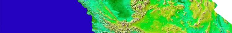
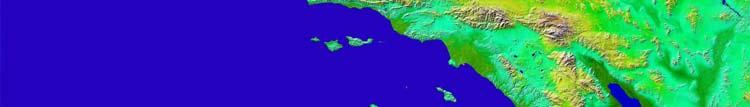
7 SARs (cont.) Los Angeles - SRTM with Landsat Overlay California-Height as color SRTM DEM's
")
8 WMO/ITU Seminar InSAR Image of the Mauna Loa Caldera in Hawaii Ground motion indicates Dangerous underground volcanic activity SARs (cont.)
 RADARSAT-1 viewing Ice off")
9 SARs (cont.) RADARSAT-1 viewing Ice off Newfoundland And Labrador, Canada
10 Altimeters Provide altitude of the Earth s ocean surface RF center frequency depends on the ocean surface interaction with the EM field t 2 t 1 (a) Dual frequency operation allows ionospheric delay compensation t (b) t JASON-1 uses frequencies around 13.6 GHz and 5.3 GHz t (c) Allowable height accuracy degradation determines the allowable interference level t (d) t r t d Illustration of Altimeter Return
11 Altimeters (cont.)
12 Scatterometers Provide the wind direction and speed over the ocean surface RF center frequency depends on the ocean surface interaction with the EM field and its variation over aspect angle Narrow RF signal bandwidth provides the needed measurement cell resolution Allowable wind speed accuracy degradation determines the allowable interference level Variation of Backscatter with Aspect Angle Radio scattering Coefficient (db) ms Horizontal Polarization ms Vertical Polarization ms Horizontal Polarization ms Vertical Polarization 12.8 ms ms Azimuth Angle (degrees) HH HH VV VV
13 Ocean scatterometers Sub-Satellite Track Sea Winds Orbit Track 800 km -45 o 45 o 40 deg -65 o Sub-Satellite Point 46 Degree Beam Nadir Track -135 o 135 o 115 o Monitor Cells Nadir 700 km Left Wind Vector Swath 175 km 175 km Right Wind Vector Swath 600 km 600 km NSCAT illuminated the Earth s surface at several different fixed aspect angles 900 km 250 to 800 km Swath* Cross Track SEAWINDS scanning pencil beam illuminates scans at two different look angles from nadir, and scans 360 degrees about nadir in azimuth
14 Scatterometers (contd)


15 Scatterometers (cont.) Polar-orbiting scatterometers observe ocean over the entire world. SeaWINDS on QuikSCAT provided these data.

16 Land scatterometers Aquarius scatterometer will illuminate the Earth s surface at several different fixed aspect/nadir angle combinations SMAP scatterometer scanning pencil beam illuminates scans at fixed look angle from nadir, and scans 360 degrees about nadir in azimuth
 Scatterometer")
 reflect")
17 Scatterometers (cont.) Scatterometer looking at land wet areas (blue) reflect back signals.
18 Precipitation Radars Provide precipitation rate over the Earth s surface, typically concentrating on rainfall in the tropics RF center frequency depends on the precipitation interaction with the EM field Narrow RF signal bandwidth provides the needed measurement cell resolution Tropical Rainfall Measurement Mission (TRMM) uses only 0.6 MHz RF bandwidth Allowable minimum precipitation reflectivity degradation determines the allowable interference level
 The TRMM image shows the precipitation profile of the hurricane Ernesto on 26 August, 2006,")
19 Precip. Radars (cont.) The TRMM image shows the precipitation profile of the hurricane Ernesto on 26 August, 2006, revealing several deep convective towers (shown in red) that top out over 15km.

20 Cloud Profile Radars Provide three dimension profile of cloud reflectivity over the Earth s surface RF center frequency depends on the ocean surface interaction with the EM field and its variation over aspect angle Antennas with very low sidelobes so as to isolate the cloud return from the higher surface return illuminated by the sidelobes Narrow RF signal bandwidth provides the needed measurement cell resolution Allowable reflectivity accuracy degradation determines the allowable interference level
 NOAA s GOES (top) showed Hurricane Ileana on Aug 23, 2006.")
21 Cloud Profilers (cont.) NOAA s GOES (top) showed Hurricane Ileana on Aug 23, CloudSat's Cloud Profiling Radar produced profiles of Ileana's clouds (bottom).
22 You have seen a variety of data products today's instruments can produce. Many* are available in a timely manner. Use them to your country's advantage. * some instruments are being demonstrated and are not in operational use.
23 And you can help - Remind your administration that these useful instruments operate in allocated frequency bands and are given protection from interference.
24 ANNEX Additional details about the technques
25 Active Sensor Characteristics Characteristics Viewing Geometry Footprint/ Dynamics Sensor Types SAR Altimeter Scatterometer Precipitation Radar deg off nadir (1) Fixed to one side (2) ScanSAR Nadirlooking Fixed at nadir (1) Three/six fan beams in azimuth (2) One/two conical scanning beams (1) Fixed in azimuth (2) Scanning Antenna Beam Fan beam Pencil beam (1) Fan beams Radiated Peak Power Waveform Spectrum Width (2) Pencil beams Nadir-looking Scanning across nadir track Pencil beam Cloud Radar Nadir-looking Fixed at nadir Pencil beam W 20 W W 600 W W Linear FM pulses Linear FM pulses Interrupted CW, Short Pulses, or linear FM pulses MHz 320 MHz 5-80 khz, 1-4 MHz Short pulses Short pulses 0.6 MHz 300 khz Duty Factor 1-5 % 46 % % 2 % 1-14 % Service Area Land/coastal/ Ocean Ocean/Ice Ocean/Ice/Land Land/Ocean Land/Ocean
26 Repeat Cycles, Swath Width and Orbital Characteristics for EESS (active) Sensors Repeat Cycle (days) Table of Orbital Characteristics of Active Spaceborne Sensors Altitude (km) Swath Width (km) Inclination (deg) SARs RadarSAT-1/2 PALSAR ERS-1/2 JERS-1/2 ALMAZ ASAR TerraSAR-L/X 16/ ,35,168/35 44/ max max 200 max/ Altimeters JASON-1/2 RA2 Topex/Poseidon Scatterometers SeaWinds ERS-1/2 NSCAT ASCAT RA Precipitation Radars TRMM GPM DPR (3 hrs for core & 8-10 LEOs) Cloud Radar Cloudsat
27 Active Sensor Type Active Sensors Applications by Sensor Type Active Sensor Applications SARS Atimeters Scatterometers Precipitation Radars Cloud Profiling Radars SARs can provide knowledge of deep and undercanopy soil moisture which is critical for several Earth - sci ence disciplines and public welfare and policy making processes. These applications include, but are not limited to: long-term weather forecasts, studying the long- and short-term climate variations through quantifying elements of the energy and water cycle, for Carbon cycle science studies, and for studies and management of underground water resources and aquifers. The data obtained by radar altimeters will be used to study ocean dynamics and their effects on climatology and meteorology. Dual frequency altimeters also operate at 5.3 GHz to provide data to compensate for -uncer tainties in height measurements caused by ionospheric effects on the 13.5 GHz measurement. The radar - alti meter will provide precise measurements of the distance from the satellite to the Earth s surface and also of the power and the shape of the returned echoes from ocean, ice and land surfaces, eventually allowing us to improve our knowledge of climatology and environmental change detection. Ocean scatterometers will measure surface wind speeds and directions over at least 90% of the oceans every two days in all weather and cloud conditions. Winds are a critical factor in determining regional weather - pat terns and global climate. Land scatterometers will measure surface echo returns to augment passive measure - ments of soil moisture and sea salinity. Scatterometers will play a key role in scientists efforts to understand and predict complex global weather patterns and climate systems. One precipitation radar is the first space mission dedicated to measuring tropical and subtropical rainfall - us ing several microwave and visible/infrared sensors. Major objectives of the PR are 1) to provide a 3-dimen - sional rainfall structure, 2) to achieve quantitative rainfall measurement over land as well as over ocean, and 3) to improve the accuracy of a microwave imager measurement by providing the rain structure information. The cloud profiling radar has been widely recognized as a key sensor to measure global distribution of clouds, which is a critical issue in understanding the cloud role in earth s radiation budget and thereby - pre dicting the global warming. The objective of spaceborne CPR is to measure global three dimensional cloud distribution. The clouds which always cover about half area of the whole earth surface, play a significant and complicated role in the earth s radiation budget. Especially, the vertical structure of clouds is a critical -para meter to decide whether clouds contribute to warming or cooling of the atmosphere.
Remote Sensing and GIS. Microwave Remote Sensing and its Applications
 Subject Paper No and Title Module No and Title Module Tag Geology Remote Sensing and GIS Microwave Remote Sensing and its Applications RS & GIS XVII Principal Investigator Co-Principal Investigator Co-Principal
HY-2A Satellite User s Guide
 National Satellite Ocean Application Service 2013-5-16 Document Change Record Revision Date Changed Pages/Paragraphs Edit Description i Contents 1 Introduction to HY-2 Satellite... 1 2 HY-2 satellite data
GEOSC/METEO 597K Kevin Bowley Kaitlin Walsh
 GEOSC/METEO 597K Kevin Bowley Kaitlin Walsh Timeline of Satellites ERS-1 (1991-2000) NSCAT (1996) Envisat (2002) RADARSAT (2007) Seasat (1978) TOPEX/Poseidon (1992-2005) QuikSCAT (1999) Jason-2 (2008)
Interpretation of Polar-orbiting Satellite Observations. Atmospheric Instrumentation
 Interpretation of Polar-orbiting Satellite Observations Outline Polar-Orbiting Observations: Review of Polar-Orbiting Satellite Systems Overview of Currently Active Satellites / Sensors Overview of Sensor
RADAR Remote Sensing Application Examples
 RADAR Remote Sensing Application Examples! All-weather capability: Microwave penetrates clouds! Construction of short-interval time series through cloud cover - crop-growth cycle! Roughness - Land cover,
APPENDIX 2 OVERVIEW OF THE GLOBAL PRECIPITATION MEASUREMENT (GPM) AND THE TROPICAL RAINFALL MEASURING MISSION (TRMM) 2-1
 AND THE TROPICAL RAINFALL MEASURING MISSION (TRMM) 2-1") APPENDIX 2 OVERVIEW OF THE GLOBAL PRECIPITATION MEASUREMENT (GPM) AND THE TROPICAL RAINFALL MEASURING MISSION (TRMM) 2-1 1. Introduction Precipitation is one of most important environmental parameters.
APPENDIX 2 OVERVIEW OF THE GLOBAL PRECIPITATION MEASUREMENT (GPM) AND THE TROPICAL RAINFALL MEASURING MISSION (TRMM) 2-1 1. Introduction Precipitation is one of most important environmental parameters.
DLR s TerraSAR-X contributes to international fleet of radar satellites to map the Arctic and Antarctica
 DLR s TerraSAR-X contributes to international fleet of radar satellites to map the Arctic and Antarctica The polar regions play an important role in the Earth system. The snow and ice covered ocean and
Radio Frequency Earth Science
 Radio Frequency Earth Science Overview for Committee On Radio Frequency (CORF) National Academy of Science National Research Council April 27, 2005 Bill.Watson@NASA.Gov Program Executive for Ground Networks
Meeting the Needs for Satellite OVW
 Meeting the Needs for Satellite OVW NEED Multiple scatterometers to extend the coverage of QuikSCAT and provide continuity UNDERWAY EUMETSAT ASCAT on METOP series 1 st is in orbit ISRO Oceansat-2 Timely
Lecture 19: Operational Remote Sensing in Visible, IR, and Microwave Channels
 MET 4994 Remote Sensing: Radar and Satellite Meteorology MET 5994 Remote Sensing in Meteorology Lecture 19: Operational Remote Sensing in Visible, IR, and Microwave Channels Before you use data from any
Lecture 4b: Meteorological Satellites and Instruments. Acknowledgement: Dr. S. Kidder at Colorado State Univ.
 Lecture 4b: Meteorological Satellites and Instruments Acknowledgement: Dr. S. Kidder at Colorado State Univ. US Geostationary satellites - GOES (Geostationary Operational Environmental Satellites) US
Application Status and Prospect of Microwave Remote Sensing
 2017 International Conference on Computing, Communications and Automation(I3CA 2017) Application Status and Prospect of Microwave Remote Sensing Cheng Lele, Yan Xinsui, Zhou Mengqiu, Zhou Yongqin, Wang
Effect of rain on Ku band fan beam Scatterometer
 Effect of rain on Ku band fan beam Scatterometer J. Tournadre, Y. Quilfen, B. Chapron Laboratoire d'océanographie Spatiale Ifremer Brest Problem/Drawback of the use of Ku-Band for radar SCAT on the future
Satellite Oceanography and Applications 2: Altimetry, scatterometry, SAR, GRACE. RMU Summer Program (AUGUST 24-28, 2015)
") Satellite Oceanography and Applications 2: Altimetry, scatterometry, SAR, GRACE RMU Summer Program (AUGUST 24-28, 2015) Altimetry 2 Basic principles of satellite altimetry Altimetry: the measurements of
Satellite Oceanography and Applications 2: Altimetry, scatterometry, SAR, GRACE RMU Summer Program (AUGUST 24-28, 2015) Altimetry 2 Basic principles of satellite altimetry Altimetry: the measurements of
NOAA/NESDIS Tropical Web Page with LEO Satellite Products and Applications for Forecasters
 NOAA/NESDIS Tropical Web Page with LEO Satellite Products and Applications for Forecasters Sheldon Kusselson National Oceanic and Atmospheric Administration (NOAA) National Environmental Satellite Data
Dual-Frequency Ku- Band Radar Mission Concept for Snow Mass
 Dual-Frequency Ku- Band Radar Mission Concept for Snow Mass Chris Derksen Environment and Climate Change Canada Study Team: Climate Research Division/Meteorological Research Division, ECCC Canadian Space
Orbit and Transmit Characteristics of the CloudSat Cloud Profiling Radar (CPR) JPL Document No. D-29695
 JPL Document No. D-29695") Orbit and Transmit Characteristics of the CloudSat Cloud Profiling Radar (CPR) JPL Document No. D-29695 Jet Propulsion Laboratory California Institute of Technology Pasadena, CA 91109 26 July 2004 Revised
Orbit and Transmit Characteristics of the CloudSat Cloud Profiling Radar (CPR) JPL Document No. D-29695 Jet Propulsion Laboratory California Institute of Technology Pasadena, CA 91109 26 July 2004 Revised
Ocean Vector Winds in Storms from the SMAP L-Band Radiometer
 International Workshop on Measuring High Wind Speeds over the Ocean 15 17 November 2016 UK Met Office, Exeter Ocean Vector Winds in Storms from the SMAP L-Band Radiometer Thomas Meissner, Lucrezia Ricciardulli,
INTRODUCTION TO MICROWAVE REMOTE SENSING. Dr. A. Bhattacharya
 1 INTRODUCTION TO MICROWAVE REMOTE SENSING Dr. A. Bhattacharya Why Microwaves? More difficult than with optical imaging because the technology is more complicated and the image data recorded is more varied.
Remote Sensing of Precipitation
 Lecture Notes Prepared by Prof. J. Francis Spring 2003 Remote Sensing of Precipitation Primary reference: Chapter 9 of KVH I. Motivation -- why do we need to measure precipitation with remote sensing instruments?
Remote Sensing I: Basics
 Remote Sensing I: Basics Kelly M. Brunt Earth System Science Interdisciplinary Center, University of Maryland Cryospheric Science Laboratory, Goddard Space Flight Center kelly.m.brunt@nasa.gov (Based on
Calibrating SeaWinds and QuikSCAT scatterometers using natural land targets
 Brigham Young University BYU ScholarsArchive All Faculty Publications 2005-04-01 Calibrating SeaWinds and QuikSCAT scatterometers using natural land targets David G. Long david_long@byu.edu Lucas B. Kunz
PREDICTION AND MONITORING OF OCEANIC DISASTERS USING MICROWAVE REMOTE SENSING TECHNIQUES
 PREDICTION AND MONITORING OF OCEANIC DISASTERS USING MICROWAVE REMOTE SENSING TECHNIQUES O P N Calla International Centre for Radio Science, OM NIWAS A-23, Shastri Nagar, Jodhpur-342 003 Abstract The disasters
Remote Sensing in Meteorology: Satellites and Radar. AT 351 Lab 10 April 2, Remote Sensing
 Remote Sensing in Meteorology: Satellites and Radar AT 351 Lab 10 April 2, 2008 Remote Sensing Remote sensing is gathering information about something without being in physical contact with it typically
P1.6 Simulation of the impact of new aircraft and satellite-based ocean surface wind measurements on H*Wind analyses
 P1.6 Simulation of the impact of new aircraft and satellite-based ocean surface wind measurements on H*Wind analyses Timothy L. Miller 1, R. Atlas 2, P. G. Black 3, J. L. Case 4, S. S. Chen 5, R. E. Hood
China France. Oceanography S A T. The CFOSAT project. e l l i t e. C. Tison (1), D. Hauser (2), A. Mouche (3) CNES, France (2)
, D. Hauser (2), A. Mouche (3) CNES, France (2)") China France The CFOSAT project C. Tison (1), D. Hauser (2), A. Mouche (3) (1) CNES, France (2) OVSQ, CNRS, LATMOS-IPSL, France (3) IFREMER, LOS, France celine.tison@cnes.fr Oceanography S A T e l l i
China France The CFOSAT project C. Tison (1), D. Hauser (2), A. Mouche (3) (1) CNES, France (2) OVSQ, CNRS, LATMOS-IPSL, France (3) IFREMER, LOS, France celine.tison@cnes.fr Oceanography S A T e l l i
A two-season impact study of the Navy s WindSat surface wind retrievals in the NCEP global data assimilation system
 A two-season impact study of the Navy s WindSat surface wind retrievals in the NCEP global data assimilation system Li Bi James Jung John Le Marshall 16 April 2008 Outline WindSat overview and working
EVALUATING THE QUIKSCAT/SEAWINDS RADAR FOR MEASURING RAINRATE OVER THE OCEANS USING COLLOCATIONS WITH NEXRAD AND TRMM
 JP2.9 EVALUATING THE QUIKSCAT/SEAWINDS RADAR FOR MEASURING RAINRATE OVER THE OCEANS USING COLLOCATIONS WITH NEXRAD AND TRMM David E. Weissman* Hofstra University, Hempstead, New York 11549 Mark A. Bourassa
INCREASED UTILITY OF SEA WINDS THROUGH ENHANCED CALIBRATION
 INCREASED UTILITY OF SEA WINDS THROUGH ENHANCED CALIBRATION Peter Yoho Brigham Young University Microwave Earth Remote Sensing Laboratory 459 Clyde Building, Provo, UT 84602 801-422-4884, FAX: 801-422-0201,
Remote sensing of sea ice
 Remote sensing of sea ice Ice concentration/extent Age/type Drift Melting Thickness Christian Haas Remote Sensing Methods Passive: senses shortwave (visible), thermal (infrared) or microwave radiation
EVALUATION OF WINDSAT SURFACE WIND DATA AND ITS IMPACT ON OCEAN SURFACE WIND ANALYSES AND NUMERICAL WEATHER PREDICTION
 5.8 EVALUATION OF WINDSAT SURFACE WIND DATA AND ITS IMPACT ON OCEAN SURFACE WIND ANALYSES AND NUMERICAL WEATHER PREDICTION Robert Atlas* NOAA/Atlantic Oceanographic and Meteorological Laboratory, Miami,
F O U N D A T I O N A L C O U R S E
 F O U N D A T I O N A L C O U R S E December 6, 2018 Satellite Foundational Course for JPSS (SatFC-J) F O U N D A T I O N A L C O U R S E Introduction to Microwave Remote Sensing (with a focus on passive
COMPARISON OF SATELLITE DERIVED OCEAN SURFACE WIND SPEEDS AND THEIR ERROR DUE TO PRECIPITATION
 COMPARISON OF SATELLITE DERIVED OCEAN SURFACE WIND SPEEDS AND THEIR ERROR DUE TO PRECIPITATION A.-M. Blechschmidt and H. Graßl Meteorological Institute, University of Hamburg, Hamburg, Germany ABSTRACT
CALIBRATING THE QUIKSCAT/SEAWINDS RADAR FOR MEASURING RAINRATE OVER THE OCEANS
 CALIBRATING THE QUIKSCAT/SEAWINDS RADAR FOR MEASURING RAINRATE OVER THE OCEANS David E. Weissman Hofstra University, Hempstead, New York 11549 Mark A. Bourassa COAPS/The Florida State University, Tallahassee,
Related missions and programs for Snowfall and Snow Hydrology of JAXA
 Related missions and programs for Snowfall and Snow Hydrology of JAXA ALOS AVNIR-2 2006/11/05 Shuji Shimizu Japan Aerospace Exploration Agency (JAXA) Earth Observation Research Center (EORC) JAXA Earth
Fri. Apr. 06, Map Projections Environmental Applications. Reading: Finish Chapter 9 ( Environmental Remote Sensing )
") Fri. Apr. 06, 2018 Map Projections Environmental Applications Reading: Finish Chapter 9 ( Environmental Remote Sensing ) Once again -- Satellites old but principles still apply Skim Sabins Chapter 10.
Fri. Apr. 06, 2018 Map Projections Environmental Applications Reading: Finish Chapter 9 ( Environmental Remote Sensing ) Once again -- Satellites old but principles still apply Skim Sabins Chapter 10.
Atmospheric Lidar The Atmospheric Lidar (ATLID) is a high-spectral resolution lidar and will be the first of its type to be flown in space.
 is a high-spectral resolution lidar and will be the first of its type to be flown in space.") www.esa.int EarthCARE mission instruments ESA s EarthCARE satellite payload comprises four instruments: the Atmospheric Lidar, the Cloud Profiling Radar, the Multi-Spectral Imager and the Broad-Band Radiometer.
www.esa.int EarthCARE mission instruments ESA s EarthCARE satellite payload comprises four instruments: the Atmospheric Lidar, the Cloud Profiling Radar, the Multi-Spectral Imager and the Broad-Band Radiometer.
High Resolution Vector Wind Retrieval from SeaWinds Scatterometer Data
 High Resolution Vector Wind Retrieval from SeaWinds Scatterometer Data David G. Long Brigham Young University, 459 Clyde Building, Provo, UT 84602 long@ee.byu.edu http://www.scp.byu.edu Abstract The SeaWinds
Julia Figa-Saldaña & Klaus Scipal
 Julia Figa-Saldaña & Klaus Scipal julia.figa@eumetsat.int klaus.scipal@esa.int Meeting, Outline MetOp/EPS status MetOp/EPS Second Generation status 2016 scatterometer conference Other European ocean programme
"Cloud and Rainfall Observations using Microwave Radiometer Data and A-priori Constraints" Christian Kummerow and Fang Wang Colorado State University
 "Cloud and Rainfall Observations using Microwave Radiometer Data and A-priori Constraints" Christian Kummerow and Fang Wang Colorado State University ECMWF-JCSDA Workshop Reading, England June 16-18, 2010
J16.1 PRELIMINARY ASSESSMENT OF ASCAT OCEAN SURFACE VECTOR WIND (OSVW) RETRIEVALS AT NOAA OCEAN PREDICTION CENTER
 RETRIEVALS AT NOAA OCEAN PREDICTION CENTER") J16.1 PRELIMINARY ASSESSMENT OF ASCAT OCEAN SURFACE VECTOR WIND (OSVW) RETRIEVALS AT NOAA OCEAN PREDICTION CENTER Khalil. A. Ahmad* PSGS/NOAA/NESDIS/StAR, Camp Springs, MD Joseph Sienkiewicz NOAA/NWS/NCEP/OPC,
J16.1 PRELIMINARY ASSESSMENT OF ASCAT OCEAN SURFACE VECTOR WIND (OSVW) RETRIEVALS AT NOAA OCEAN PREDICTION CENTER Khalil. A. Ahmad* PSGS/NOAA/NESDIS/StAR, Camp Springs, MD Joseph Sienkiewicz NOAA/NWS/NCEP/OPC,
Aquarius Pioneering the L- band Passive and Ac6ve Microwave Remote Sensing of Sea Surface Salinity and Wind
 Aquarius Pioneering the L- band Passive and Ac6ve Microwave Remote Sensing of Sea Surface Salinity and Wind SIMON YUEH, WENQING TANG, ALEXANDER FORE, AKIKO HAYASHI Jet Propulsion Laboratory, California
Japanese Programs on Space and Water Applications
 Japanese Programs on Space and Water Applications Tamotsu IGARASHI Remote Sensing Technology Center of Japan June 2006 COPUOS 2006 Vienna International Centre Water-related hazards/disasters may occur
Development of Spaceborne Dualfrequency. and Its Role for the Global Precipitation Measurement
 Development of Spaceborne Dualfrequency Precipitation Radar and Its Role for the Global Precipitation Measurement Shinsuke Satoh (1), Riko Oki (1), Nobuhiro Takahashi (2), and Toshio Iguchi (2) (1) National
Remote sensing of precipitation extremes
 The panel is about: Understanding and predicting weather and climate extreme Remote sensing of precipitation extremes Climate extreme : (JSC meeting, June 30 2014) IPCC SREX report (2012): Climate Ali
Interferometric Synthetic Aperture Radar (InSAR) and GGOS. Andrea Donnellan NASA/JPL February 21, 2007
 and GGOS. Andrea Donnellan NASA/JPL February 21, 2007") Interferometric Synthetic Aperture Radar (InSAR) and GGOS Andrea Donnellan NASA/JPL February 21, 2007 Sources for Science Objectives Fourth component of EarthScope Involvement: NSF, NASA, USGS, Universities
Interferometric Synthetic Aperture Radar (InSAR) and GGOS Andrea Donnellan NASA/JPL February 21, 2007 Sources for Science Objectives Fourth component of EarthScope Involvement: NSF, NASA, USGS, Universities
Before the FEDERAL COMMUNICATIONS COMMISSION Washington, DC 20554
 Before the FEDERAL COMMUNICATIONS COMMISSION Washington, DC 20554 In the Matter of ) ) Recommendations Approved by the ) Advisory Committee for the 2007 World ) IB Docket No. 04-286 Radiocommunication
EUMETSAT STATUS AND PLANS
 1 EUM/TSS/VWG/15/826793 07/10/2015 EUMETSAT STATUS AND PLANS François Montagner, Marine Applications Manager, EUMETSAT WMO Polar Space Task Group 5 5-7 October 2015, DLR, Oberpfaffenhofen PSTG Strategic
IOVWST Meeting, Sapporo/Japan, May 2016
 IOVWST Meeting, Sapporo/Japan, May 2016 The Design and Performance of the SCA Radar carried by the METOP Second Generation Satellites J. J. W. Wilson, C. Anderson EUMETSAT, Darmstadt, Germany. A. Ostergaard,
Assimilation of satellite derived soil moisture for weather forecasting
 Assimilation of satellite derived soil moisture for weather forecasting www.cawcr.gov.au Imtiaz Dharssi and Peter Steinle February 2011 SMOS/SMAP workshop, Monash University Summary In preparation of the
The NASA EV-2 Cyclone Global Navigation Satellite System (CYGNSS) Mission
 Mission") International Ocean Vector Wind Science Team Meeting Kailua-Kona, Hawaii USA 6-8 May 2013 The NASA EV-2 Cyclone Global Navigation Satellite System (CYGNSS) Mission Chris Ruf (1) (CYGNSS Principal Investigator),
International Ocean Vector Wind Science Team Meeting Kailua-Kona, Hawaii USA 6-8 May 2013 The NASA EV-2 Cyclone Global Navigation Satellite System (CYGNSS) Mission Chris Ruf (1) (CYGNSS Principal Investigator),
Long term performance monitoring of ASCAT-A
 Long term performance monitoring of ASCAT-A Craig Anderson and Julia Figa-Saldaña EUMETSAT, Eumetsat Allee 1, 64295 Darmstadt, Germany. Abstract The Advanced Scatterometer (ASCAT) on the METOP series of
Question 1: Do you have any comments on our approach to this review?:
 Question 1: Do you have any comments on our approach to this review?: No. Question 2: Do you have any comments on our broad overview of the satellite sector set out in this section? In particular, do you
P. Cipollini, H. Snaith - A short course on Altimetry. Altimetry 2 - Data processing (from satellite height to sea surface height)
") P. Cipollini, H. Snaith - A short course on Altimetry Altimetry 2 - Data processing (from satellite height to sea surface height) 1 2 Satellite height to sea surface height The altimeter measures the altitude
P. Cipollini, H. Snaith - A short course on Altimetry Altimetry 2 - Data processing (from satellite height to sea surface height) 1 2 Satellite height to sea surface height The altimeter measures the altitude
Active microwave systems (2) Satellite Altimetry * the movie * applications
 Satellite Altimetry * the movie * applications") Remote Sensing: John Wilkin wilkin@marine.rutgers.edu IMCS Building Room 211C 732-932-6555 ext 251 Active microwave systems (2) Satellite Altimetry * the movie * applications Altimeters (nadir pointing
Remote Sensing: John Wilkin wilkin@marine.rutgers.edu IMCS Building Room 211C 732-932-6555 ext 251 Active microwave systems (2) Satellite Altimetry * the movie * applications Altimeters (nadir pointing
CGMS Baseline. Sustained contributions to the Global Observing System. Endorsed by CGMS-46 in Bengaluru, June 2018
 CGMS Baseline Sustained contributions to the Global Observing System Best Practices for Achieving User Readiness for New Meteorological Satellites Endorsed by CGMS-46 in Bengaluru, June 2018 CGMS/DOC/18/1028862,
JAXA s Contributions to the Climate Change Monitoring
 0 JAXA s Contributions to the Climate Change Monitoring June 7, 2011 Takao Akutsu Planning Manager Japan Aerospace Exploration Agency (JAXA) Japanese Main Activities of Earth Observation 1 GEOSS 10 years
Inventory & Evaluation of Space-based Instruments: Using OSCAR for space weather
 WMO OMM World Meteorological Organization Working together in weather, climate and water Inventory & Evaluation of Space-based Instruments: Using OSCAR for space weather Jérôme Lafeuille (WMO) Alain Hilgers
IMPROVED MICROWAVE REMOTE SENSING OF HURRICANE WIND SPEED AND RAIN RATES USING THE HURRICANE IMAGING RADIOMETER (HIRAD)
") IMPROVED MICROWAVE REMOTE SENSING OF HURRICANE WIND SPEED AND RAIN RATES USING THE HURRICANE IMAGING RADIOMETER (HIRAD) Salem F. El-Nimri*, Suleiman Al-Sweiss, Ruba A Christopher S. Ruf Amarin, W. Linwood
IMPROVED MICROWAVE REMOTE SENSING OF HURRICANE WIND SPEED AND RAIN RATES USING THE HURRICANE IMAGING RADIOMETER (HIRAD) Salem F. El-Nimri*, Suleiman Al-Sweiss, Ruba A Christopher S. Ruf Amarin, W. Linwood
SMAP and SMOS Integrated Soil Moisture Validation. T. J. Jackson USDA ARS
 SMAP and SMOS Integrated Soil Moisture Validation T. J. Jackson USDA ARS Perspective Linkage of SMOS and SMAP soil moisture calibration and validation will have short and long term benefits for both missions.
Detection, tracking and study of polar lows from satellites Leonid P. Bobylev
 Detection, tracking and study of polar lows from satellites Leonid P. Bobylev Nansen Centre, St. Petersburg, Russia Nansen Centre, Bergen, Norway Polar lows and their general characteristics International
New Era of Global Monitoring by ALOS-2: Advanced Land Observing Satellite-2 DAICHI-2 Yuko Suzuki
 New Era of Global Monitoring by ALOS-2: Advanced Land Observing Satellite-2 DAICHI-2 Yuko Suzuki International Relations and Research Department Japan Aerospace Exploration Agency (JAXA) 1 Dawning Era
Status of Indian Satellite Meteorological Programme
 Status of Indian Satellite Meteorological Programme Pradeep K Thapliyal Space Applications Centre (SAC) Indian Space research Organisation (ISRO) Ahmedabad (INDIA) Email: pkthapliyal@sac.isro.gov.in International
Blended Sea Surface Winds Product
 1. Intent of this Document and POC Blended Sea Surface Winds Product 1a. Intent This document is intended for users who wish to compare satellite derived observations with climate model output in the context
4 Forecasting Weather
 CHAPTER 16 4 Forecasting Weather SECTION Understanding Weather BEFORE YOU READ After you read this section, you should be able to answer these questions: What instruments are used to forecast weather?
Observations of Arctic snow and sea ice thickness from satellite and airborne surveys. Nathan Kurtz NASA Goddard Space Flight Center
 Observations of Arctic snow and sea ice thickness from satellite and airborne surveys Nathan Kurtz NASA Goddard Space Flight Center Decline in Arctic sea ice thickness and volume Kwok et al. (2009) Submarine
Status report on the current and future meteorological satellite systems by CMA
 Status report on the current and future meteorological satellite systems by CMA Presented to CGMS-44Plenary session, agenda item [D.1] Overview - Planning of China satellite systems by year 2025 NSIP:
Eight Years of TRMM Data: Understanding Regional Mechanisms Behind the Diurnal Cycle
 Eight Years of TRMM Data: Understanding Regional Mechanisms Behind the Diurnal Cycle Steve Nesbitt, Rob Cifelli, Steve Rutledge Colorado State University Chuntao Liu, Ed Zipser University of Utah Funding
Outline of 4 Lectures
 Outline of 4 Lectures 1. Sept. 17, 2008: TC best track definition and datasets, global distribution of TCs; Review of history of meteorological satellites, introducing different orbits, scanning patterns,
Module 11: Meteorology Topic 5 Content: Weather Maps Notes
 Introduction A variety of weather maps are produced by the National Weather Service and National Oceanographic Atmospheric Administration. These maps are used to help meteorologists accurately predict
Current and Upcoming NASA Hurricane Measurement Missions National Hurricane Conference
 NASA Science Mission Directorate Earth Science Division Applied Sciences Program Current and Upcoming NASA Hurricane Measurement Missions National Hurricane Conference April 18, 2017 Formulation Implementation
INTRODUCTION 1-1 TYPES AND CLASSES OF REMOTE SENSING DATA
 1 INTRODUCTION Remote sensing is defined as the acquisition of information about an object without being in physical contact with it. Information is acquired by detecting and measuring changes that the
REVISION OF THE STATEMENT OF GUIDANCE FOR GLOBAL NUMERICAL WEATHER PREDICTION. (Submitted by Dr. J. Eyre)
") WORLD METEOROLOGICAL ORGANIZATION Distr.: RESTRICTED CBS/OPAG-IOS (ODRRGOS-5)/Doc.5, Add.5 (11.VI.2002) COMMISSION FOR BASIC SYSTEMS OPEN PROGRAMME AREA GROUP ON INTEGRATED OBSERVING SYSTEMS ITEM: 4 EXPERT
WORLD METEOROLOGICAL ORGANIZATION Distr.: RESTRICTED CBS/OPAG-IOS (ODRRGOS-5)/Doc.5, Add.5 (11.VI.2002) COMMISSION FOR BASIC SYSTEMS OPEN PROGRAMME AREA GROUP ON INTEGRATED OBSERVING SYSTEMS ITEM: 4 EXPERT
Remote Sensing of Ocean Winds
 Remote Sensing of Ocean Winds Stephen Frasier Dept. of Electrical and Computer Engineering Offshore Wind Energy IGERT Seminar 3/5/2015 Remote Sensing of Wind For wind energy applications: Wind Profilers
QuikSCAT Analysis of Hurricane Force Extratropical Cyclones in the Pacific Ocean
 University of Rhode Island DigitalCommons@URI Senior Honors Projects Honors Program at the University of Rhode Island 2010 QuikSCAT Analysis of Hurricane Force Extratropical Cyclones in the Pacific Ocean
GAP ANALYSIS FOR SATELLITE MISSIONS SUPPORTING THE GOS
 WMO OMM World Meteorological Organization Working together in weather, climate and water GAP ANALYSIS FOR SATELLITE MISSIONS SUPPORTING THE GOS CGMS-39 WMO-WP-31, Agenda item III.5 Dr B. Bizzarri, Consultant
OSE/OSSEs at NOAA. Eric Bayler NOAA/NESDIS/STAR
 OSE/OSSEs at NOAA Eric Bayler NOAA/NESDIS/STAR OSE/OSSEs at NOAA NOAA Leadership view: Relatively inexpensive way to: Assess the impact of potential new observations Refine and redirect current observing
Microwave Remote Sensing of Soil Moisture. Y.S. Rao CSRE, IIT, Bombay
 Microwave Remote Sensing of Soil Moisture Y.S. Rao CSRE, IIT, Bombay Soil Moisture (SM) Agriculture Hydrology Meteorology Measurement Techniques Survey of methods for soil moisture determination, Water
Status of GCOM and expectation for microwave scatterometer
 Status of GCOM and expectation for microwave scatterometer Keiji Imaoka 1, Misako Kachi 1, Tamotsu Igarashi 1, Keizo Nakagawa 1, Naoto Ebuchi 2, Taikan Oki 1,3, and Haruhisa Shimoda 1,4 1 Japan Aerospace
Introduction to SMAP. ARSET Applied Remote Sensing Training. Jul. 20,
 National Aeronautics and Space Administration ARSET Applied Remote Sensing Training http://arset.gsfc.nasa.gov @NASAARSET Introduction to SMAP Jul. 20, 2016 www.nasa.gov Outline 1. Mission objectives 2.
EFFECTS OF ALONG-TRACK INTEGRATION ON DOPPLER VELOCITY BIAS WITH A SPACEBORNE CLOUD-PROFILING RADAR
 P3.11 EFFECTS OF ALONG-TRACK INTEGRATION ON DOPPLER VELOCITY BIAS WITH A SPACEBORNE CLOUD-PROFILING RADAR Akihisa Uematsu 1 *, Yuichi Ohno 1, Hiroaki Horie 1,2, Hiroshi Kumagai 1, and Nick Schutgens 3
Airborne Measurement of Snow Thickness Over Sea Ice
 Airborne Measurement of Snow Thickness Over Sea Ice Uniquiea B. Wade Elizabeth City State University Elizabeth City, North Carolina 27909 Abstract Snow cover on sea ice plays an important role in the climate
Making a case for full-polarimetric radar remote sensing
 Making a case for full-polarimetric radar remote sensing Jeremy Nicoll Alaska Satellite Facility, University of Alaska Fairbanks 1 Polarization States of a Coherent Plane Wave electric field vector vertically
TRMM, Hydrologic Science, and Societal Benefit: The Role of Satellite Measurements
 TRMM, Hydrologic Science, and Societal Benefit: The Role of Satellite Measurements Michael H. Freilich TRMM 15 th Anniversary Symposium 12 November 2012 KEY TRMM ATTRIBUTES Long on-orbit lifetime 15 years
Geoscience Australia Report on Cal/Val Activities
 Medhavy Thankappan Geoscience Australia Agency Report I Berlin May 6-8, 2015 Outline 1. Calibration / validation at Geoscience Australia Corner reflector infrastructure for SAR calibration (for information)
NEW CGMS BASELINE FOR THE SPACE-BASED GOS. (Submitted by the WMO Secretariat) Summary and Purpose of Document
 Summary and Purpose of Document") WORLD METEOROLOGICAL ORGANIZATION COMMISSION FOR BASIC SYSTEMS OPEN PROGRAMME AREA GROUP ON INTEGRATED OBSERVING SYSTEMS EXPERT TEAM ON SATELLITE SYSTEMS ET-SAT-7/Inf. 2 (12.III.2012) ITEM: 8.1 SEVENTH
WORLD METEOROLOGICAL ORGANIZATION COMMISSION FOR BASIC SYSTEMS OPEN PROGRAMME AREA GROUP ON INTEGRATED OBSERVING SYSTEMS EXPERT TEAM ON SATELLITE SYSTEMS ET-SAT-7/Inf. 2 (12.III.2012) ITEM: 8.1 SEVENTH
New NASA Ocean Observations and Coastal Applications
 New NASA Ocean Observations and Coastal Applications Duane Armstrong Chief, Applied Science & Technology Project Office August 20, 2014 1 Outline NASA s new Earth Science Ocean Science Missions for 2014
Contribution to global Earth observation from satellites
 Contribution to global Earth observation from satellites - JAXA s Earth Observation strategy - April 16, 2008 Makoto Kajii Japan Aerospace Exploration Agency Earth Observation Summits and GEOSS 1 st EO
Lecture 4: Meteorological Satellites and Instruments. Acknowledgement: Dr. S. Kidder at Colorado State Univ.
 Lecture 4: Meteorological Satellites and Instruments Acknowledgement: Dr. S. Kidder at Colorado State Univ. Homework for the Spring Break: get some tangible, preliminary results for your final project.
Investigate the influence of the Amazon rainfall on westerly wind anomalies and the 2002 Atlantic Nino using QuikScat, Altimeter and TRMM data
 Investigate the influence of the Amazon rainfall on westerly wind anomalies and the 2002 Atlantic Nino using QuikScat, Altimeter and TRMM data Rong Fu 1, Mike Young 1, Hui Wang 2, Weiqing Han 3 1 School
Impact of METOP ASCAT Ocean Surface Winds in the NCEP GDAS/GFS and NRL NAVDAS
 Impact of METOP ASCAT Ocean Surface Winds in the NCEP GDAS/GFS and NRL NAVDAS COAMPS @ Li Bi 1,2 James Jung 3,4 Michael Morgan 5 John F. Le Marshall 6 Nancy Baker 2 Dave Santek 3 1 University Corporation
ASCAT NRT Data Processing and Distribution at NOAA/NESDIS
 ASCAT NRT Data Processing and Distribution at NOAA/NESDIS Paul S. Chang, Zorana Jelenak, Seubson Soisuvarn, Qi Zhu Gene Legg and Jeff Augenbaum National Oceanic and Atmospheric Administration (NOAA) National
WIND PROFILER NETWORK OF JAPAN METEOROLOGICAL AGENCY
 WIND PROFILER NETWORK OF JAPAN METEOROLOGICAL AGENCY Masahito Ishihara Japan Meteorological Agency CIMO Expert Team on Remote Sensing Upper-Air Technology and Techniques 14-17 March, 2005 Geneva, Switzerland
Spaceborne and Ground-based Global and Regional Precipitation Estimation: Multi-Sensor Synergy
 Hydrometeorology and Remote Sensing Lab (hydro.ou.edu) at The University of Oklahoma Spaceborne and Ground-based Global and Regional Precipitation Estimation: Multi-Sensor Synergy Presented by: 温逸馨 (Berry)
Review of GNSS as sources of opportunity for Earth Observation
 NOAA UK-MetOffice Joofix Review of GNSS as sources of opportunity for Earth Observation Dr. Estel Cardellach (ICE-CSIC/IEEC, Spain) HISDESAT ESA Overview Motivation: contribution to a sustained and efficient
Title: The Impact of Convection on the Transport and Redistribution of Dust Aerosols
 Authors: Kathryn Sauter, Tristan L'Ecuyer Title: The Impact of Convection on the Transport and Redistribution of Dust Aerosols Type of Presentation: Oral Short Abstract: The distribution of mineral dust
4 Forecasting Weather
 CHAPTER 2 4 Forecasting Weather SECTION Understanding Weather BEFORE YOU READ After you read this section, you should be able to answer these questions: What instruments are used to forecast weather? How
Unit 5 Lesson 3 How is Weather Predicted? Copyright Houghton Mifflin Harcourt Publishing Company
 Tracking the Weather Warm up 1 Why is it important to watch the weather forecast before traveling to another country? Tracking the Weather A meteorologist is a scientist who studies weather. Meteorologists
CLIMATE CHANGE AND REGIONAL HYDROLOGY ACROSS THE NORTHEAST US: Evidence of Changes, Model Projections, and Remote Sensing Approaches
 CLIMATE CHANGE AND REGIONAL HYDROLOGY ACROSS THE NORTHEAST US: Evidence of Changes, Model Projections, and Remote Sensing Approaches Michael A. Rawlins Dept of Geosciences University of Massachusetts OUTLINE
Model based forest height estimation with ALOS/PalSAR: A first study.
 Model based forest height estimation with ALOS/PalSAR: A first study. K.P. Papathanassiou*, I. Hajnsek*, T.Mette*, S.R. Cloude** and A. Moreira* * (DLR) (DLR-HR) Oberpfaffenhofen, Germany ** AEL Consultants