Results of the ESA-DUE UHI project
|
|
|
- Roger Sanders
- 5 years ago
- Views:
Transcription

1 13/12/2011 Results of the ESA-DUE UHI project Bino Maiheu on behalf of the UHI project
2 Outline» Urban heat island problem» The ESA-DUE urban heat island project» UHI air temperature modeling approach» TIR user requirements analysis» Requirements for UHI modeling» Importance of synergetic observations for studying UHI 13/12/2011 2


3 The urban heat island» Discomfort : thermal stress & deaths» Energy Consumption, airconditioning» Atmospheric chemistry (O 3, emissions from energy consumption)» Local meteorology e.g. encreased rainfall downwind of cities» Increased mixing heights, urban plume» Higher temperature run-off water temperature stresses ecosystems London New Orleans,Tailor & Muñoz, /12/2011 3


")
4 Thermal remote sensing and UHI» Urban heat mitigation initiatives in many cities in Europe» Clear added value of TIR remote sensing : LST retrievals!» Optimize emergency response, reduce risk, asses mitigation measures» Study building energy efficiency (airborne thermography)» Aid in improving forecast, integration in urban climate modeling tools» J.A. Voogt, T.R. Oke, Thermal remote sensing of urban climates (2003), Remote Sensing of Environment 86 (2003) /12/2011 4
 Airborne (10m) IR CAM (10cm)")
5 Multi-scale analysis Oke, 1997 AVHRR (1km) Airborne (10m) IR CAM (10cm) 13/12/2011 5
6 The UHI project» Project financed by ESA in framework of DUE program, started end 2008.» Quite ambitious goals :» Build archive of 10 years worth of LST retrievals for various sensors for 10 European cities : Madrid, Lisbon, Athens, Brussels, Budapest, Sevilla, Paris, London, Bari, Thessaloniki» Integration / assimilation of satellite remote sensing observations : Land Surface Temperature and ground weather stations data into urban meteorological and climate models, to facilitate preventing the impact of UHI and to reduce the risk of a heat wave» Study user requirements for new TIR satellite sensor from the UHI perspective» IEG : J. Sobrino, Benedicte Dousset, Kostas Kourtidis 13/12/2011 6
7 13/12/2011 7
8 Data sources UHI project Sensor TIR Spatial Resolution Night/Day Revisiting # TIR bands MSG-Seviri 3km (5km) ND Geostat., 15min 5 NOAA AVHRR 1.1 km ND [12hr] 2 MODIS (Terra AM, Aqua PM) 1 km ND Daily 10 Envisat-AATSR 1 km ND Daily 2 Landsat (TM/ETM+) 120 m / 60 m D, [N] 16 days 1 ASTER 90 m D 16 days 4 13/12/2011 8


9 Ensemble Stdev Surface Temp [K] Air temperature modeling approach /01 07/02 07/03 07/04 07/05 07/06 07/07 07/08 07/09 07/10 07/11 H Ts Model LST Ens STD Ens STD A LE 2 07/01 07/02 07/03 07/04 07/05 07/06 07/07 07/08 07/09 07/10 07/11 Ensemble data assimilation technique 13/12/2011 9
10 13/12/
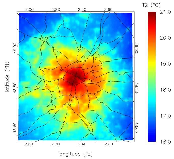
11 Validation over Paris /12/
12 The UHI project of ESA Cities and User communities involved 10 European Municipalities Belgium: France: Greece (2): Italy: Brussels Paris, Athens, Thessaloniki Bari Spain (2): Portugal: UK: Hungary: Madrid, Seville Lisbon London Budapest» TIR requirements analysis (contribution to the mission requirements for a high resolution TIR (Thermal Infra Red) satellite sensor ('Reorientation of the Fuegosat Consolidation Phase') Health prevention, emergencies management and risk analysis Energy efficiency (including winter thermography) Urban planning Urban environmental quality Meteorological services 13/12/

13 Spatial resolution vs. revisit time gaps Source: INDRA 13/12/

 13/12/2011 14")
14 Spatial resolution 10 m 50 m 100 m Madrid, Retiro park 2008 (DESIREX) 13/12/ m 1 km
15 TIR Requirements synthesis (INDRA) Meteorological services / Emergencies / Urban Environment al Quality Observation time Spatial resolution Revisit time The time of observation shall be at least of 2 images per day with a minimum amplitude of 6 hours, and ideally 3 images per day The spatial resolution should be < 500 m The revisit time should be < Daily Spectral Sampling At least two bands centred on 9 µm and 12 µm. Desirable: 4 Timeliness The delivery shall be NRT Energy Efficiency and Urban Planning Observation time Spatial resolution Spectral Sampling Revisit Time The time of observation should be ideally 2 images per day with a large amplitude (minimum amplitude of 6 hours) The spatial resolution should be between 1m and max 4 TIR Bands The revisit time should be weekly or more 13/12/ Source: INDRA
16 LST in urban climate modeling» MSG-SEVIRI too coarse, but still useful for UHI dynamics over large metropolitan areas, e.g. estimate kb -1» De Ridder, K., C. Bertrand, G. Casanova, W. Lefebvre, and S. Mekaoui, Estimating urban thermophysical properties using thermal infared geostationary remote sensing. In preparation» Revisit time of 1 km sensors, capturing the daily amplitude, night & day!» Uncertainty of urban surface emissivity» Temperature Emissivity Separation (TES) algorithms best suited» Multiple TIR bands needed» Anisotropy, directional effects in TIR radiance : nadir view vs. off nadir view» Make use of it / correct for it? 13/12/
 443-462) : airborne» Directional effects of -5 +7 K!")
17 Directional effects» J-P Lagouarde (Remote Sensing of Env. 93 (2004) ) : airborne» Directional effects of K!!!» Low res instruments (AVHRR, AATSR) can have incidence angles up to 60 13/12/
» Photo-chemistry : T dependence of O 3 NO 2» Urban plume profile measurements 13/12/2011 18")
18 Importance of other synergetic observations Other important parameters for UHI modeling / studies» FVC, Albedo, urban surface characterization» Atmospheric Composition» Aerosol extinction & effect on UHI?» Effects on long wave radiation loss (greenhouse effect)» Photo-chemistry : T dependence of O 3 NO 2» Urban plume profile measurements 13/12/

19 13/12/
Soil emissivity spectra for ground and remote sensing thermal calibration. J. A. Sobrino, C. Mattar,, S. Hook,, J. C. Jiménez
 Soil emissivity spectra for ground and remote sensing thermal calibration J. A. Sobrino, C. Mattar,, S. Hook,, J. C. Jiménez Global Change Unit, University of Valencia, Spain. Experimental Setup FTIR spectra
ASSESSING CLIMATE CHANGE IN CITIES USING URBCLIM. Hooyberghs, H.; De Ridder, K.; Lauwaet, D.; Maiheu, B.; Lefebvre, W.
 ASSESSING CLIMATE CHANGE IN CITIES USING URBCLIM Hooyberghs, H.; De Ridder, K.; Lauwaet, D.; Maiheu, B.; Lefebvre, W. Overview» The urban heat island» UrbClim model» Description» Validation» Current climate
LAND SURFACE ALBEDO AND DOWNWELLING SHORTWAVE RADIATION FROM MSG GEOSTATIONARY SATELLITE (METHOD FOR RETRIEVAL, VALIDATION, AND APPLICATION)
") LAND SURFACE ALBEDO AND DOWNWELLING SHORTWAVE RADIATION FROM MSG GEOSTATIONARY SATELLITE (METHOD FOR RETRIEVAL, VALIDATION, AND APPLICATION) Dominique Carrer, Jean-Louis Roujean, Olivier Hautecoeur, Jean-Christophe
LAND SURFACE ALBEDO AND DOWNWELLING SHORTWAVE RADIATION FROM MSG GEOSTATIONARY SATELLITE (METHOD FOR RETRIEVAL, VALIDATION, AND APPLICATION) Dominique Carrer, Jean-Louis Roujean, Olivier Hautecoeur, Jean-Christophe
Satellite observation of atmospheric dust
 Satellite observation of atmospheric dust Taichu Y. Tanaka Meteorological Research Institute, Japan Meteorological Agency 11 April 2017, SDS WAS: Dust observation and modeling @WMO, Geneva Dust observations
MONITORING THE SURFACE HEAT ISLAND (SHI) EFFECTS OF INDUSTRIAL ENTERPRISES
 EFFECTS OF INDUSTRIAL ENTERPRISES") MONITORING THE SURFACE HEAT ISLAND (SHI) EFFECTS OF INDUSTRIAL ENTERPRISES A. Şekertekin a, *, Ş. H. Kutoglu a, S. Kaya b, A. M. Marangoz a a BEU, Engineering Faculty, Geomatics Engineering Department
MONITORING THE SURFACE HEAT ISLAND (SHI) EFFECTS OF INDUSTRIAL ENTERPRISES A. Şekertekin a, *, Ş. H. Kutoglu a, S. Kaya b, A. M. Marangoz a a BEU, Engineering Faculty, Geomatics Engineering Department
Measuring the surface temperatures of the earth from space. Darren Ghent, University of Leicester 13/09/2018
 Measuring the surface temperatures of the earth from space Darren Ghent, University of Leicester 13/09/2018 Contents Background Challenges of measuring Land Surface Temperature Applications Current capability
Satellite-based Lake Surface Temperature (LST) Homa Kheyrollah Pour Claude Duguay
 Homa Kheyrollah Pour Claude Duguay") Satellite-based Lake Surface Temperature (LST) Homa Kheyrollah Pour Claude Duguay Lakes in NWP models Interaction of the atmosphere and underlying layer is the most important issue in climate modeling
Satellite-based Lake Surface Temperature (LST) Homa Kheyrollah Pour Claude Duguay Lakes in NWP models Interaction of the atmosphere and underlying layer is the most important issue in climate modeling
Land Surface Temperature in the EUMETSAT LSA SAF: Current Service and Perspectives. Isabel Trigo
 Land Surface Temperature in the EUMETSAT LSA SAF: Current Service and Perspectives Isabel Trigo Outline EUMETSAT Land-SAF: Land Surface Temperature Geostationary Service SEVIRI Polar-Orbiter AVHRR/Metop
Retrievals of Land surface temperature using LANDSAT8 and ASTER data over Italian volcanic areas: comparison of satellites and in situ measurements
 Retrievals of Land surface temperature using LANDSAT8 and ASTER data over Italian volcanic areas: comparison of satellites and in situ measurements M.F. Buongiorno, M. Silvestri, M. Musacchio Istituto
METRIC tm. Mapping Evapotranspiration at high Resolution with Internalized Calibration. Shifa Dinesh
 METRIC tm Mapping Evapotranspiration at high Resolution with Internalized Calibration Shifa Dinesh Outline Introduction Background of METRIC tm Surface Energy Balance Image Processing Estimation of Energy
Snow Cover Applications: Major Gaps in Current EO Measurement Capabilities
 Snow Cover Applications: Major Gaps in Current EO Measurement Capabilities Thomas NAGLER ENVEO Environmental Earth Observation IT GmbH INNSBRUCK, AUSTRIA Polar and Snow Cover Applications User Requirements
ASSESSING THERMAL RISK IN URBAN AREAS AN APPLICATION FOR THE URBAN AGGLOMERATION OF ATHENS
 ASSESSING THERMAL RISK IN URBAN AREAS AN APPLICATION FOR THE URBAN AGGLOMERATION OF ATHENS Polydoros T. and Cartalis C. Department of Environmental Physics, University of Athens, University Campus, Build
An Algorithm for Retrieving Land Surface Temperatures Using VIIRS Data in Combination with Multi-Sensors
 Sensors 2014, 14, 21385-21408; doi:10.3390/s141121385 Article OPEN ACCESS sensors ISSN 1424-8220 www.mdpi.com/journal/sensors An Algorithm for Retrieving Land Surface Temperatures Using VIIRS Data in Combination
C. Jimenez, C. Prigent, F. Aires, S. Ermida. Estellus, Paris, France Observatoire de Paris, France IPMA, Lisbon, Portugal
 All-weather land surface temperature estimates from microwave satellite observations, over several decades and real time: methodology and comparison with infrared estimates C. Jimenez, C. Prigent, F. Aires,
ESTIMATION OF ATMOSPHERIC COLUMN AND NEAR SURFACE WATER VAPOR CONTENT USING THE RADIANCE VALUES OF MODIS
 ESTIMATION OF ATMOSPHERIC COLUMN AND NEAR SURFACE WATER VAPOR CONTENT USIN THE RADIANCE VALUES OF MODIS M. Moradizadeh a,, M. Momeni b, M.R. Saradjian a a Remote Sensing Division, Centre of Excellence
GFAS Methodology & Results
 GFAS Methodology & Results Johannes W. Kaiser, Imke Hüser, Berit Gehrke Max Planck Institute for Chemistry, DE Tadas Nikonovas, Weidong Xu, Martin G. Wooster King s College London, UK Ioannis Bistinas,
Critical review of the Climate Change Impact on urban areas by assessment of Heat Island effect
 Critical review of the Climate Change Impact on urban areas by assessment of Heat Island effect Case of Pune, India Town Planning, Civil Department Prof. Omkar Parishwad, ogp.civil@coep.ac.in Climate Change
An Eye in the Sky EUMETSAT. Monitoring Weather, Climate and the Environment
 An Eye in the Sky EUMETSAT Monitoring Weather, Climate and the Environment Slide: 1 Hazardous Weather Slide: 2 Hazardous Weather Slide: 3 Natural Disasters set off by severe weather Slide: 4 EUMETSAT Objectives...
Isabel Trigo, Sandra Freitas, Carla Barroso, Isabel Monteiro, Pedro Viterbo
 Land Surface Temperature, Emissivity and Long-Wave Downwlling Fluxes from MSG Observations: current status and way forward Isabel Trigo, Sandra Freitas, Carla Barroso, Isabel Monteiro, Pedro Viterbo 1
EUMETSAT SAF NETWORK. Lothar Schüller, EUMETSAT SAF Network Manager
 1 EUMETSAT SAF NETWORK Lothar Schüller, EUMETSAT SAF Network Manager EUMETSAT ground segment overview METEOSAT JASON-2 INITIAL JOINT POLAR SYSTEM METOP NOAA SATELLITES CONTROL AND DATA ACQUISITION FLIGHT
THE USE OF REMOTE SENSING AND GEOSPATIAL TECHNIQUES FOR URBAN CLIMATE ANALYSIS: A CASE STUDY OF ABU DHABI CITY AREA
 THE USE OF REMOTE SENSING AND GEOSPATIAL TECHNIQUES FOR URBAN CLIMATE ANALYSIS: A CASE STUDY OF ABU DHABI CITY AREA Michele Lazzarini, Jacinto Estima, Prashanth Reddy Marpu, Hosni Ghedira Earth Observation
AN ACCURACY ASSESSMENT OF AATSR LST DATA USING EMPIRICAL AND THEORETICAL METHODS
 AN ACCURACY ASSESSMENT OF AATSR LST DATA USING EMPIRICAL AND THEORETICAL METHODS Elizabeth Noyes, Gary Corlett, John Remedios, Xin Kong, and David Llewellyn-Jones Department of Physics and Astronomy, University
Estimation of Wavelet Based Spatially Enhanced Evapotranspiration Using Energy Balance Approach
 Estimation of Wavelet Based Spatially Enhanced Evapotranspiration Using Energy Balance Approach Dr.Gowri 1 Dr.Thirumalaivasan 2 1 Associate Professor, Jerusalem College of Engineering, Department of Civil
Instrumentation planned for MetOp-SG
 Instrumentation planned for MetOp-SG Bill Bell Satellite Radiance Assimilation Group Met Office Crown copyright Met Office Outline Background - the MetOp-SG programme The MetOp-SG instruments Summary Acknowledgements:
satellite techniques for measuring surface temperatures: INGV participation to ESA DUE GLOB Temperature
 satellite techniques for measuring surface temperatures: INGV participation to ESA DUE GLOB Temperature Maria Fabrzia Buongiorno, Massimo Musacchio, Malvina Silvestri,, Claudia Spinetti, Laura Colini,
ENERGY IN THE URBAN ENVIRONMENT: USE OF TERRA/ASTER IMAGERY AS A TOOL IN URBAN PLANNING N. CHRYSOULAKIS*
 ENERGY IN THE URBAN ENVIRONMENT: USE OF TERRA/ASTER IMAGERY AS A TOOL IN URBAN PLANNING N. CHRYSOULAKIS* Foundation for Research and Technology Hellas, Institute of Applied and Computational Mathematics,
ESA Climate Change Initiative (CCI)
") ESA Climate Change Initiative (CCI) New ESA Programme with the aim to contribute to worldwide efforts to generate Essential Climate Variables (ECVs) C. Zehner Barcelona, 07/09/2009 Two climate action paths
ESA Climate Change Initiative (CCI) New ESA Programme with the aim to contribute to worldwide efforts to generate Essential Climate Variables (ECVs) C. Zehner Barcelona, 07/09/2009 Two climate action paths
Remote Sensing of Urban Surface Temperatures
 Remote Sensing of Urban Surface Temperatures James Voogt University of Western Ontario London, Ontario, Canada This work is supported by the Natural Sciences and Engineering Research Council of Canada.
Saharan Dust Longwave Radiative Forcing using GERB and SEVIRI
 Imperial College London Saharan Dust Longwave Radiative Forcing using GERB and SEVIRI Vincent Gimbert 1, H.E. Brindley 1, Nicolas Clerbaux 2, J.E. Harries 1 1. Blackett Laboratory, Imperial College, London
Spatial Geotechnologies and GIS tools for urban planners applied to the analysis of urban heat island. Case Caracas city, Venezuela Contribution 115.
 planners applied to the analysis of urban heat island. Case Caracas city, Venezuela Contribution 115. Fig.1 The city of Caracas, as many others Latin-American cities, has experimented a fast growth in
REMOTE SENSING AND GIS AS POLLUTION MODEL VALIDATION AND EMISSION ASSESSMENT TOOLS. Athens, Athens, Greece
 REMOTE SENSING AND GIS AS POLLUTION MODEL VALIDATION AND EMISSION ASSESSMENT TOOLS Michael Petrakis 1, Theodora Kopania 1, David Briggs 2, Asbjorn Aaheim 3, Gerard Hoek 4, Gavin Shaddick 5, Adrianos Retalis
Operational systems for SST products. Prof. Chris Merchant University of Reading UK
 Operational systems for SST products Prof. Chris Merchant University of Reading UK Classic Images from ATSR The Gulf Stream ATSR-2 Image, ƛ = 3.7µm Review the steps to get SST using a physical retrieval
330: Daytime urban heat island intensity in London during the winter season
 330: Daytime urban heat island intensity in London during the winter season Giridharan Renganathan Brunel University Abstract This paper will present results of the daytime urban heat island intensity
Climate Modeling Research & Applications in Wales. John Houghton. C 3 W conference, Aberystwyth
 Climate Modeling Research & Applications in Wales John Houghton C 3 W conference, Aberystwyth 26 April 2011 Computer Modeling of the Atmosphere & Climate System has revolutionized Weather Forecasting and
WMO SDS-WAS. Observational needs. Enric Terradellas, AEMET, Barcelona chair of the WMO SDS-WAS Steering Committtee
 WMO SDS-WAS Observational needs Enric Terradellas, AEMET, Barcelona eterradellasj@aemet.es chair of the WMO SDS-WAS Steering Committtee GAW Symposium, Geneva, Switzerland, 10-13 April 2017 WMO SDS-WAS
WMO OSCAR. Observing Systems Capability Analysis and Review Tool A building block of Rolling Requirements Review
 WMO OSCAR Observing Systems Capability Analysis and Review Tool A building block of Rolling Requirements Review Quantitative user-defined requirements for observation of physical variables in application
Lectures 7 and 8: 14, 16 Oct Sea Surface Temperature
 Lectures 7 and 8: 14, 16 Oct 2008 Sea Surface Temperature References: Martin, S., 2004, An Introduction to Ocean Remote Sensing, Cambridge University Press, 454 pp. Chapter 7. Robinson, I. S., 2004, Measuring
Satellite-Based Detection of Fog and Very Low Stratus
 Satellite-Based Detection of Fog and Very Low Stratus A High-Latitude Case Study Centred on the Helsinki Testbed Experiment J. Cermak 1, J. Kotro 2, O. Hyvärinen 2, V. Nietosvaara 2, J. Bendix 1 1: Laboratory
MERSEA Marine Environment and Security for the European Area
 MERSEA Marine Environment and Security for the European Area Development of a European system for operational monitoring and forecasting of the ocean physics, biogeochemistry, and ecosystems, on global
Accuracy and Precision Requirements for Climate-Level Data Sets
 Accuracy and Precision Requirements for Climate-Level Data Sets K. Thome NASA/GSFC Libya-4 Workshop Paris, France October 4-5, 2012 Accuracy requirements Commercial imagers Precision and SNR drive calibration
C o p e r n i c u s L a n d M o n i t o r i n g S e r v i c e
 C o p e r n i c u s L a n d M o n i t o r i n g S e r v i c e Integration into existing Snow and Ice Services and draft product specifications Annett BARTSCH b.geos Copernicus High Resolution Snow and
Current capabilities and limitations of satellite monitoring and modeling forecasting of volcanic clouds: and example of Eyjafjallaj
 Current capabilities and limitations of satellite monitoring and modeling forecasting of volcanic clouds: and example of Eyjafjallaj fjallajökull eruption (pronounced EYE-a-fyat fyat-la-jo-kotl) N. Krotkov
EUMETSAT Satellite Programmes Use of McIDAS at EUMETSAT
 EUMETSAT Satellite Programmes Use of McIDAS at EUMETSAT Marianne König Peter Miu McIDAS Users' Group Meeting, 07-10 May 2012 Slide 1 EUMETSAT Headquarters Darmstadt McIDAS Users' Group Meeting, 07-10 May
Impact of NASA EOS data on the scientific literature: 16 years of published research results from Terra, Aqua, Aura, and Aquarius
 Impact of NASA EOS data on the scientific literature: 16 years of published research results from Terra, Aqua, Aura, and Aquarius Gene R. Major NASA Goddard Library Nebulous Connections April 4, 2017 RESACs/RA
Eyja volcanic ash retrievals by using MODIS data
 INGV Eyja volcanic ash retrievals by using MODIS data S. Corradini, L. Merucci, A. Piscini Remote Sensing Group INGV (Rome) ESRIN May 26-27, 2010 Outline Ash retrieval algorithms in the TIR spectral range
sentinel-3 A BIGGER PICTURE FOR COPERNICUS
 sentinel-3 A BIGGER PICTURE FOR COPERNICUS SATELLITES TO SERVE By providing a set of key information services for a wide range of practical applications, Europe s Copernicus programme has been put in place
Mapping Evapotranspiration and Drought at Local to Continental Scales Using Thermal Remote Sensing
 Mapping Evapotranspiration and Drought at Local to Continental Scales Using Thermal Remote Sensing M.C. Anderson, W.P. Kustas USDA-ARS, Hydrology and Remote Sensing Laboratory J.M Norman University of
INTERCOMPARISON OF METEOSAT-8 DERIVED LST WITH MODIS AND AATSR SIMILAR PRODUCTS
 INTERCOMPARISON OF METEOSAT-8 DERIVED LST WITH MODIS AND AATSR SIMILAR PRODUCTS Cristina Madeira, Prasanjit Dash, Folke Olesen, and Isabel Trigo, Instituto de Meteorologia, Rua C- Aeroporto, 700-09 Lisboa,
Cloud masking as cross-cutting issue
 Cloud masking as cross-cutting issue Presentation to CEOS/WGCV activity project planning meeting Rainer Hollmann, Cornelia Schlundt, Satellite based Climate Monitoring Deutscher Wetterdienst Outline Need
MSG system over view
 MSG system over view 1 Introduction METEOSAT SECOND GENERATION Overview 2 MSG Missions and Services 3 The SEVIRI Instrument 4 The MSG Ground Segment 5 SAF Network 6 Conclusions METEOSAT SECOND GENERATION
Super-resolution of MTSAT Land Surface Temperature by Blending MODIS and AVNIR2
 Super-resolution of MTSAT Land Surface Temperature by Blending MODIS and AVNIR2 Wataru Takeuchi 1*, Kei Oyoshi 2 and Shin Akatsuka 3 1 Institute of Industrial Science, University of Tokyo, Japan (6-1,
Application of Remotely Sensed Data in the Estimation of Net Radiation at the Earth s Surface in Clear Sky Conditions
 American Journal of Remote Sensing 2018; 6(1): 23-28 http://www.sciencepublishinggroup.com/j/ajrs doi: 10.11648/j.ajrs.20180601.14 ISSN: 2328-5788 (Print); ISSN: 2328-580X (Online) Application of Remotely
Modelling the Atmospheric Urban Heat Island and its Contributing Spatial Characteristics
 the Atmospheric Urban Heat Island and its Contributing Characteristics The Case of The Hague, the Netherlands Anna-Maria Ntarladima 07/11/2016 Urban Heat Island (UHI) is a phenomenon in which a city forms
EUMETSAT. A global operational satellite agency at the heart of Europe. Presentation for the Spanish Industry Day Madrid, 15 March 2012
 EUMETSAT A global operational satellite agency at the heart of Europe Presentation for the Spanish Industry Day Madrid, Angiolo Rolli EUMETSAT Director of Administration EUMETSAT objectives The primary
CAMS. Vincent-Henri Peuch (ECMWF) Atmosphere Monitoring. Copernicus EU.
 Atmosphere Monitoring. Copernicus EU.") CAMS COPERNICUS ATMOSPHERE M O NITO RING SERVICE Vincent-Henri Peuch (ECMWF) Copernicus EU Copernicus EU Copernicus EU www.copernicus.eu W H A T I S C O P E R N I C U S? Copernicus Copernicus is a flagship
CAMS COPERNICUS ATMOSPHERE M O NITO RING SERVICE Vincent-Henri Peuch (ECMWF) Copernicus EU Copernicus EU Copernicus EU www.copernicus.eu W H A T I S C O P E R N I C U S? Copernicus Copernicus is a flagship
Use of satellite information in research and operational activities at NIMH of Bulgaria
 Use of satellite information in research and operational activities at NIMH of Bulgaria Rilka Valcheva NIMH, Bulgaria WMO/EUMETSAT Satellite Products Training Course 24-28 April 2017, Budapest, Hungary
ECMWF global reanalyses: Resources for the wind energy community
 ECMWF global reanalyses: Resources for the wind energy community (and a few myth-busters) Paul Poli European Centre for Medium-range Weather Forecasts (ECMWF) Shinfield Park, RG2 9AX, Reading, UK paul.poli
Applications of GIS and Remote Sensing for Analysis of Urban Heat Island
 Chuanxin Zhu Professor Peter V. August Professor Yeqiao Wang NRS 509 December 15, 2016 Applications of GIS and Remote Sensing for Analysis of Urban Heat Island Since the last century, the global mean surface
An experimental study of angular variations of brightness surface temperature for some natural surfaces
 An experimental study of angular variations of brightness surface temperature for some natural surfaces Juan Cuenca, José A. Sobrino, and Guillem Soria University of Valencia, c./ Dr. Moliner 5, 46 Burjassot,
H SAF SATELLITE APPLICATION FACILITY ON SUPPORT TO OPERATIONAL HYDROLOGY AND WATER MANAGEMENT EUMETSAT NETWORK OF SATELLITE APPLICATION FACILITIES
 H SAF SATELLITE APPLICATION FACILITY ON SUPPORT TO OPERATIONAL HYDROLOGY AND WATER MANAGEMENT EUMETSAT NETWORK OF SATELLITE APPLICATION FACILITIES H-SAF: SATELLITE PRODUCTS FOR OPERATIONAL HYDROLOGY H-SAF
Aerosol measurements from Space. Gerrit de Leeuw FMI & Uni of Helsinki, Finland & TNO, Utrecht, Netherlands
 Aerosol measurements from Space Gerrit de Leeuw FMI & Uni of Helsinki, Finland & TNO, Utrecht, Netherlands ACCENT AT-2 Follow-up meeting Mainz, 22 June 2009 ACCENT AT-2 Outcomes The Remote Sensing of Tropospheric
Dr. Haritini Tsangari Associate Professor of Statistics University of Nicosia, Cyprus
 Dr. Haritini Tsangari Associate Professor of Statistics University of Nicosia, Cyprus H. Tsangari (presenting) 1, Z. Konsoula 1, S. Christou 1, K. E. Georgiou 2, K. Ioannou 3, T. Mesimeris 3, S. Kleanthous
OSI SAF SST Products and Services
 OSI SAF SST Products and Services Pierre Le Borgne Météo-France/DP/CMS (With G. Legendre, A. Marsouin, S. Péré, S. Philippe, H. Roquet) 2 Outline Satellite IR radiometric measurements From Brightness Temperatures
Back to basics: From Sputnik to Envisat, and beyond: The use of satellite measurements in weather forecasting and research: Part 1 A history
 Back to basics: From Sputnik to Envisat, and beyond: The use of satellite measurements in weather forecasting and research: Part 1 A history Roger Brugge 1 and Matthew Stuttard 2 1 NERC Data Assimilation
Data assimilation of IASI radiances over land.
 Data assimilation of IASI radiances over land. PhD supervised by Nadia Fourrié, Florence Rabier and Vincent Guidard. 18th International TOVS Study Conference 21-27 March 2012, Toulouse Contents 1. IASI
Module 3 False ideas and other theoretical issues
 FORmation of Multi-disciplinary Approaches to Training in Earth Observation Erasmus Intensive Programmes Module 3 False ideas and other theoretical issues FORmation of Multi-disciplinary Approaches to
EUMETSAT SAF NETWORK. Lothar Schüller, EUMETSAT SAF Network Manager
 1 EUMETSAT SAF NETWORK Lothar Schüller, EUMETSAT SAF Network Manager EUMETSAT ground segment overview METEOSAT JASON-2 INITIAL JOINT POLAR SYSTEM METOP NOAA SATELLITES CONTROL AND DATA ACQUISITION FLIGHT
LAND SURFACE TEMPERATURE VALIDATION WITH IN SITU MEASUREMENTS
 LAND SURFACE TEMPERATURE VALIDATION WITH IN SITU MEASUREMENTS Group 7 Juan Manuel González Cantero Irene Grimaret Rincón Alex Webb Advisor: Darren Ghent Research problem The project task is to design an
The Challenge of. Guy Brasseur
 The Challenge of Monitoring and Predicting Chemical Weather Guy Brasseur Introduction: What is Chemical Weather? What is Chemical Weather? Local, regional, and global distributions of important trace gases
Learning Objectives. Thermal Remote Sensing. Thermal = Emitted Infrared
 November 2014 lava flow on Kilauea (USGS Volcano Observatory) (http://hvo.wr.usgs.gov) Landsat-based thermal change of Nisyros Island (volcanic) Thermal Remote Sensing Distinguishing materials on the ground
MODELING URBAN THERMAL ANISOTROPY
 MODELING URBAN THERMAL ANISOTROPY J. A. Voogt a, *, E. S. Krayenhoff a a Department of Geography, University of Western Ontario, London ON N6A 5C2 Canada -javoogt@uwo.ca KEY WORDS: surface temperature,
A new perspective on aerosol direct radiative effects in South Atlantic and Southern Africa
 A new perspective on aerosol direct radiative effects in South Atlantic and Southern Africa Ian Chang and Sundar A. Christopher Department of Atmospheric Science University of Alabama in Huntsville, U.S.A.
COMPARISON OF NOAA/AVHRR AND LANDSAT/TM DATA IN TERMS OF RESEARCH APPLICATIONS ON THERMAL CONDITIONS IN URBAN AREAS
 COMPARISON OF NOAA/AVHRR AND LANDSAT/TM DATA IN TERMS OF RESEARCH APPLICATIONS ON THERMAL CONDITIONS IN URBAN AREAS Monika J. Hajto 1 *, Jakub P. Walawender 2,3 and Piotr Struzik 2 1 Department of Air
Land surface albedo from MSG/SEVIRI: retrieval method, validation, and application for weather forecast
 Land surface albedo from MSG/SEVIRI: retrieval method, validation, and application for weather forecast Dominique Carrer, Benhard Geiger, Jean-Louis Roujean, Olivier Hautecoeur, Jure Cedilnik, Jean-François
Lecture 4b: Meteorological Satellites and Instruments. Acknowledgement: Dr. S. Kidder at Colorado State Univ.
 Lecture 4b: Meteorological Satellites and Instruments Acknowledgement: Dr. S. Kidder at Colorado State Univ. US Geostationary satellites - GOES (Geostationary Operational Environmental Satellites) US
Understanding Weather and Climate Risk. Matthew Perry Sharing an Uncertain World Conference The Geological Society, 13 July 2017
 Understanding Weather and Climate Risk Matthew Perry Sharing an Uncertain World Conference The Geological Society, 13 July 2017 What is risk in a weather and climate context? Hazard: something with the
THE LAND-SAF SURFACE ALBEDO AND DOWNWELLING SHORTWAVE RADIATION FLUX PRODUCTS
 THE LAND-SAF SURFACE ALBEDO AND DOWNWELLING SHORTWAVE RADIATION FLUX PRODUCTS Bernhard Geiger, Dulce Lajas, Laurent Franchistéguy, Dominique Carrer, Jean-Louis Roujean, Siham Lanjeri, and Catherine Meurey
Regional Production, Quarterly report on the daily analyses and forecasts activities, and verification of the CHIMERE performances
 ECMWF COPERNICUS REPORT Copernicus Atmosphere Monitoring Service Regional Production, Quarterly report on the daily analyses and forecasts activities, and verification of the CHIMERE performances September
WWRP Implementation Plan Reporting
 WWRP Implementation Plan Reporting This report will form the basis of the WWRP report to the upcoming session of the WMO Commission for Atmospheric Sciences. As you respond to this request please think
Remote Sensing of SWE in Canada
 Remote Sensing of SWE in Canada Anne Walker Climate Research Division, Environment Canada Polar Snowfall Hydrology Mission Workshop, June 26-28, 2007 Satellite Remote Sensing Snow Cover Optical -- Snow
Improved assimilation of IASI land surface temperature data over continents in the convective scale AROME France model
 Improved assimilation of IASI land surface temperature data over continents in the convective scale AROME France model Niama Boukachaba, Vincent Guidard, Nadia Fourrié CNRM-GAME, Météo-France and CNRS,
E-AIMS. SST: synthesis of past use and design activities and plans for E-AIMS D4.432
 Research Project co-funded by the European Commission Research Directorate-General 7 th Framework Programme Project No. 312642 E-AIMS Euro-Argo Improvements for the GMES Marine Service SST: synthesis of
Atmospheric correction in presence of sun glint: the POLYMER Algorithm
 Atmospheric correction in presence of sun glint: the POLYMER Algorithm Dominique Jolivet François Steinmetz Pierre-Yves Deschamps Jan 17, 2011 Atelier National Couleur de l'eau - GIS COOC c 2011 Atmospheric
Challenges for the operational assimilation of satellite image data in agrometeorological models
 Challenges for the operational assimilation of satellite image data in agrometeorological models Mark Danson Centre for Environmental Systems Research, University of Salford, UK 0 Objectives The main objective
Regional Production, Quarterly report on the daily analyses and forecasts activities, and verification of the CHIMERE performances
 ECMWF COPERNICUS REPORT Copernicus Atmosphere Monitoring Service Regional Production, Quarterly report on the daily analyses and forecasts activities, and verification of the CHIMERE performances June
Operational event attribution
 Operational event attribution Peter Stott, NCAR, 26 January, 2009 August 2003 Events July 2007 January 2009 January 2009 Is global warming slowing down? Arctic Sea Ice Climatesafety.org climatesafety.org
Analysing Land Surface Emissivity with Multispectral Thermal Infrared Data
 2nd Workshop on Remote Sensing and Modeling of Surface Properties 9-11 June 2009, Météo France, Toulouse, France Analysing Land Surface Emissivity with Multispectral Thermal Infrared Data Maria Mira, Thomas
Current research issues. Philippe Bougeault, Météo France
 Current research issues for short range NWP Philippe Bougeault, Météo France The expectations from government and society as seen from Météo France Improve the accuracy of short range forecasts for security
The BEYOND Center of Excellence for monitoring natural disasters from space
 The BEYOND Center of Excellence for monitoring natural disasters from space Ioannis Papoutsis National Observatory of Athens Institute for Astronomy, Astrophysics, Space Applications & Remote Sensing MOWE-IT
sentinel-2 COLOUR VISION FOR COPERNICUS
 sentinel-2 COLOUR VISION FOR COPERNICUS SATELLITES TO SERVE By providing a set of key information services for a wide range of practical applications, Europe s Copernicus programme is providing a step
Remote Sensing I: Basics
 Remote Sensing I: Basics Kelly M. Brunt Earth System Science Interdisciplinary Center, University of Maryland Cryospheric Science Laboratory, Goddard Space Flight Center kelly.m.brunt@nasa.gov (Based on
African dust and forest fires: Impacts on health MED-PARTICLES-LIFE+ project
 African dust and forest fires: Impacts on health MED-PARTICLES-LIFE+ project Massimo Stafoggia Barcelona, April 28 th 2015 Particles size and composition in Mediterranean countries: geographical variability
Air quality. EU GEMS project. European air quality satellite missions. Hennie Kelder. KNMI University of Technology, Eindhoven
 Air quality EU GEMS project European air quality satellite missions Hennie Kelder KNMI University of Technology, Eindhoven Global and regional Earth-System (atmosphere) Monitoring using Satellite and in-situ
Remote sensing Based Assessment of Urban Heat Island Phenomenon in Nagpur Metropolitan Area
 International Journal of Information & Computation Technology. ISSN 0974-2239 Volume 4, Number 11 (2014), pp. 1069-1074 International Research Publications House http://www. irphouse.com Remote sensing
Comparison between Land Surface Temperature Retrieval Using Classification Based Emissivity and NDVI Based Emissivity
 Comparison between Land Surface Temperature Retrieval Using Classification Based Emissivity and NDVI Based Emissivity Isabel C. Perez Hoyos NOAA Crest, City College of New York, CUNY, 160 Convent Avenue,
Open Access Earth Observation in Support of Urban Resilience and Climate Adaptability
 Send Orders for Reprints to reprints@benthamscience.ae The Open Remote Sensing Journal, 2015, 6, 17-22 17 Open Access Earth Observation in Support of Urban Resilience and Climate Adaptability Plans C.
Abstract: Introduction: 10 th ESRI India User Conference 2009 Geography in Action
 Mitigation of Thermal Pollution to enhance urban air quality through Remote Sensing and GIS Anshu Gupta, Lecturer, Centre of Remote Sensing and GIS, MANIT, Bhopal, E- mail: anshugupta20002001@gmail.com
NWC-SAF Satellite Application Facility in Support to Nowcasting and Very Short Range Forecasting
 NWC-SAF Satellite Application Facility in Support to Nowcasting and Very Short Range Forecasting Marianne König Slide 1 Satellite Application Facilities (SAFs) in Europe Member State Cooperating State
Regional Production, Quarterly report on the daily analyses and forecasts activities, and verification of the EURAD-IM performances
 ECMWF COPERNICUS REPORT Copernicus Atmosphere Monitoring Service Regional Production, Quarterly report on the daily analyses and forecasts activities, and verification of the EURAD-IM performances March
Remote Sensing Based Inversion of Gap Fraction for Determination of Leaf Area Index. Alemu Gonsamo 1 and Petri Pellikka 1
 Remote Sensing Based Inversion of Gap Fraction for Determination of Leaf Area Index Alemu Gonsamo and Petri Pellikka Department of Geography, University of Helsinki, P.O. Box, FIN- Helsinki, Finland; +-()--;