Measuring the surface temperatures of the earth from space. Darren Ghent, University of Leicester 13/09/2018
|
|
|
- Isabel Curtis
- 5 years ago
- Views:
Transcription

1 Measuring the surface temperatures of the earth from space Darren Ghent, University of Leicester 13/09/2018
2 Contents Background Challenges of measuring Land Surface Temperature Applications Current capability
3 What is Land Surface Temperature Land Surface Temperature (LST) is a measure of how hot or cold the surface of the Earth would feel to the touch For ground-based, airborne, and spaceborne remote sensing instruments it is the aggregated radiometric surface temperature of the ensemble of components within the sensor field of view LST is an independent temperature data set for quantifying climate change complementary to the near-surface air temperature ECV based on in situ measurements and reanalyses From a climate perspective, LST is important for: evaluation of land surface and land-atmosphere exchange processes constraint of surface energy budgets and flux variations global and regional observations of surface temperature variations LST can be determined from thermal emission at wavelengths in either infrared (IR) or microwave (MW) atmospheric windows

4 Sentinel-3 Land Surface Temperature

5 Sentinel-3 Land Surface Temperature
6 Importance of LST for climate LST increasingly recognised as an essential parameter for diagnosing Earth System behaviour and evaluating Earth System Models: provides a globally consistent record from satellite of radiative temperatures of the Earth s surface provides a crucial constraint on surface energy budgets, particularly in moisture-limited states - the LST record contains the imprint of climate events related to water stress and availability provides a metric of surface state when combined with vegetation parameters and soil moisture, and is related to the driving of vegetation phenology. an important source of information for deriving surface air temperature in regions with sparse measurement stations, such as parts of Africa and the Arctic A long, stable record of LST is particularly useful for model evaluation in regions where few in situ measurements of surface air temperature exist and for attribution of observed changes in such regions to their possible causes The climate user community already use and need LST data.
7 How we measure Surface Temperature How is it measured? Planck Function Radiation Curves Radiative Transfer Equation Thermal Infrared (TIR) atmospheric Window (~8-13μm) Split-Window and/or Dual angle Algorithms Mean radiative temperature over pixel area L sat L ground L atm L atm_ reflected L sat is the radiance measured by the satellite sensor L ground is the upwelling radiance emitted by the ground L atm is the upwelling radiance emitted by the atmosphere L atm_reflected is the down-welling radiance emitted by the atmosphere and reflected by the ground
8 A Simple Radiative Transfer Approach B i L L T B LST 1 sensor i i i BT measured by the sensor channel Surface emissivity Atmospheric effects Radiometers are used to measure the top-of-atmosphere brightness temperature (BT). To obtain ST from infrared satellite measurements, we need to correct for the effects of the atmosphere and non-unity of surface emissivity. Sea: The surface emissivity is very well behaved. The atmosphere tends to be spatially homogeneous except for some aerosol advection/broken cloud. A split-window algorithm is used (11/12 μm with addition of 3.7 μm channel at night for SST). Atmospheric effects and emissivity correction are implicitly handled through a coefficient approach.
9 Infrared or Microwave Retrievals? Microwaves are able to penetrate clouds and so offer a more continuous source of data However: The signal originating from Earth is stronger at IR wavelengths The Planck function peaks in the IR Higher surface emissivity of terrestrial materials in IR Rate of change of radiance is lower in the microwave A higher radiometric resolution is required to obtain the same precision Measurements from microwave instruments are at a lower spatial resolution
10 Atmospheric effects Even in the atmospheric window of high transmission attenuation is still significant Most attenuation at these wavelengths is due to water vapour absorption Stratospheric and tropospheric aerosols also depress infrared radiances Both atmospheric effects and emissivity variability need to accounted for to avoid retrieval errors of up to 12K (Sobrino and Raissouni, IJRS, 2000; Sobrino et al., IJRS, 2003) Most common approach is the Generalised Split-Window (GSW) algorithm GSW corrects the atmospheric effects based on the differential absorption in adjacent channels Transmission is highest in the 8-13μm window
11 Thermal infra-red Emissivity Emissivity is the relative ability of the surface to emit radiation It is quantified as the ratio of energy radiated by the surface with respect to the energy radiated by a black body (ε = 1) at the same temperature Surface emissivities can be highly variable owing to the heterogeneity of the land. Factors influencing emissivity include: Surface type Fractional vegetation cover Soil moisture Can range from less than 0.94 for some sandy soils to over 0.99 for some regions of inland water or snow and ice Variability of surface emissivities is amplified in regions of high topographic variance and for larger viewing angles. Need to accurately deal with uncertainties otherwise biases can occur in LST retrieval of several degrees (Schaadlich et al., RSE, 2001).


12 Thermal infra-red Emissivity Emissivity 11μm channel Emissivity 12μm channel Biome - Globcover LST
13 Long-term multi-channel IR LST AATSR ENVISAT, Polar Orbiting Sun-Synchronous (~10.00a.m. descending) Launched 2001, EOL 08/04/2012 Mission Series (ATSR-1 and ATSR-2) since 1991 SST derived from TIR channels: 3.7, 11 and 12 μm High Spatial Resolution (1 km 2 ) Narrow swath width (512 km) Exceptional radiometric calibration; dual-view AVHRR NOAA + METOP, Polar Orbiting Sun-Synchronous (a.m. descending) Mission Series stretching back to SST derived from TIR channels: 11 and 12μm High Spatial Resolution (1 km 2 ) Wide swath width (~2500 km) MODIS 2 Polar Orbiting satellites: Terra and Aqua Terra: Sun-Synchronous (~10.30a.m. descending) Launched 1999 Aqua: Sun-Synchronous (~13.30a.m. descending) Launched 2002 SST derived from TIR channels: 11 and 12μm High Spatial Resolution (1 km 2 ) Wide swath width (2330km) SEVIRI Meteosat9/MSG2 Geostationary (0 latitude, 0 longitude) Launched 2005, EOL 2015 SST derived from TIR channels: 10.8 and 12 μm High Temporal Resolution (15mins) Coverage within +/- 60 Spatial Resolution: 3km at nadir; +6km above 60
14 How does LST compare with T air Strong diurnal cycle Differences of as much as 20K for same scene Stronger non-uniformity within a landscape Comparison example: GlobTemperature MODIS (Aqua) GHCN/D (results coutesy of L. Good, Hadley Centre in framework of EU H2020 EUSTACE Project) LST min T min [range between K (MAM) and 0.79 K (JJA)] LST max T max [range between K (DJF) and 1.76 K (JJA)] LST ngt often reasonable proxy for T min
15 LST Split Window Algorithm AATSR/SLSTR Nadir retrievals only (dual angle only for SST) LST a p( ) T 11 T12 b f, i c f, i 12 f, i, pw b f, i T T 11 and T 12 are 11 and 12 m channel brightness temperatures (BT) a, b, c retrieval coefficients dependent on: Surface/vegetation type (i) - biome Vegetation fraction (f) seasonally dependent Precipitable water (pw) seasonally dependent Satellite zenith view pointing angle (p( )) Emissivity dependence encapsulated in biome and fractional vegetation factors
16 Contents Background Challenges of measuring Land Surface Temperature Applications Current capability
17 Validation Category A: Comparison of satellite LST with in situ measurements This is the traditional and most straightforward approach to validating LST. It involves a direct comparison of satellite-derived LST with collocated and simultaneously acquired LST from ground-based radiometers. Category B: Radiance-based validation This technique uses top-of-atmosphere (TOA) brightness temperatures (BTs) in conjunction with a radiative transfer model to simulate ground LST using data of surface emissivity and a atmospheric profiles of air temperature and water vapour content. Category C: Inter-comparison with similar LST products A wide variety of airborne and spaceborne instruments collects thermal infrared data and many provide operational LST products. An inter-comparison of LST products from different satellite instruments can be very valuable for determining LST. Category D: Time series analysis Analysing time series of satellite data over a temporally stable target site allows for the identification of potential calibration drift or other issues of the instrument that manifest themselves over time. Furthermore, problems associated with cloud contamination for example may be identified from artefacts evident in the time series. Care must be taken in distinguishing between instrument-related issues such as calibration drift and real geophysical changes of the target site or the atmosphere.


")


18 In-situ Validation Stations Portugal, Evora Senegal, Dahra Temperate vegetation Namibia, Gobabeb Namibia, Farms Semi-arid (tiger bush) Kalahari bush Desert Large, homogeneous sites Well characterised Different climates & biomes Dedicated to LST validation SLIDE 18
19 Validation challenges Geolocation accuracy and overpass timing Landscape heterogeneity Simultaneous measurements of each surface class ( endmember ) LST from satellite depend upon angle of observation Upscaling of nadir in situ measurements biased towards sunlit scenes Angularly anisotropic surface emissivity at the microscopic scale Requires measurements of shadow scenes and geometric projection modelling Upscaling assumptions: precise geolocation and surface area of a satellite pixel can be guaranteed for each pixel validated the same generic land cover classes can be reliably classified within and between each pixel the thermal behaviour of each land cover class remains invariant


20 Validation challenges


")
21 Challenges: Sensor Intercomparison Daytime SEVIRI view Daytime MODIS view for nadir viewing angles (left) and for positive viewing angles (right)
22 Challenges: Sensor Intercomparison LST differences between MODIS and SEVIRI as a function of zenith viewing angle by day and night
23 Challenges: Uncertainty Budgets Radiometric noise Geolocation Surface component Atmosphere component Total
24 Contents Background Challenges of measuring Land Surface Temperature Applications Current capability
25 Applications for LST Data Climate change Urban heat islands, land/atmosphere coupling, surface energy balance Modelling studies Model validation, data assimilation Land cover change Desertification, change detection Crop management Irrigation, drought stress Water management Evapotranspiration, soil moisture retrievals Fire monitoring Burned area mapping, fuel moisture content Geological applications Geothermal anomalies, volcanic activity

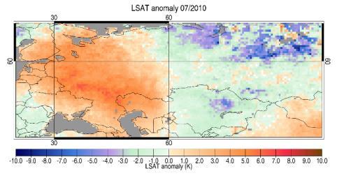
26 Applications - Heat Waves AATSR LST daytime anomalies during relative heatwaves

27 Applications - Data Assimilation Modelled vs. assimilated mean daily LST compared with NCEP skin temperature Time series of mean daily surface soil moisture in the top 5cm of the soil profile with and without LST data assimilation for values over West Africa from 1 st January 31 st May ERS scatterometer surface soil moisture observations are plotted for comparison.
28 Applications - Hydrology Why is accurate LST data important in hydrological applications? For non-vegetated surfaces water shortage at the surface of the soil causes the temperature to rapidly increase, with more energy partitioned into sensible heat. For vegetated surfaces root zone water shortage leads to stomatal closure, reduced transpiration, and higher canopy temperatures 0.5K LST error can result in a 10% error in sensible heat flux (Brutsaert et al., 1993) 1.0K LST error can lead to a 10% error in ET (Moran and Jackson, 1991) LST Errors between 1.0K and 3.0K can lead to errors as much as 100Wm -2 in heat fluxes (Kustas and Norman, 1996)


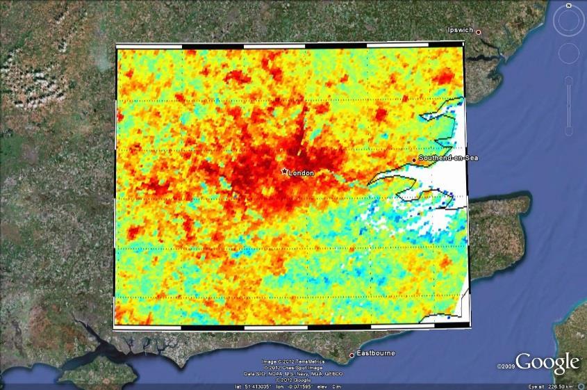
29 Applications - Urban Heat


30 Applications - Urban Heat The high spatial resolution of LANDSAT comes at the cost of temporal resolution, with 16 day image separations and the accuracy with which temperatures can be established given the need for additional input variables Surface temperature plot over central London using LANDSAT 7 thermal data 90m resolution. LST accuracy limited by a lack of high resolution urban emissivity data.


31 LST applications: Drought mapping


32 LST applications: Drought mapping
33 Improving LST representations Comparisons of LST and near-surface air temperature provide information on surface energy budget where coincident measurements are available LST delivers unique information on surface temperatures in sparsely observed regions for near-surface air temperature Consistent representations of surface temperature from LST can inform historical reconstructions. LST from IR is currently used more for climate studies Time series from ATSR LST CDR vs. CRU for North Africa (E. Good, Met Office)
34 Contents Background Challenges of measuring Land Surface Temperature Applications Current capability
 emissivity accuracy < 0.015 (1.5%) from MODIS and ASTER (eg Hulley et al.")

35 Current capability I (products) Single-sensor IR LST data-products from satellite have greatly improved: High accuracy of IR LST data: validation shows LST biases < 1.0 K from AATSR (eg Coll et al., 2012) emissivity accuracy < (1.5%) from MODIS and ASTER (eg Hulley et al., 2012) Advances in cloud detection (dynamic probabilistic approaches) Approach to uncertainties consistent with Sea Surface Temperature (SST) including validation Sessions Users Random Locally correlated ESA GlobTemperature MODIS uncertainties 0

36 Current capability I (uncertainties) Uncertainties categorised by effects whose errors have distinct correlation properties: Random locally systematic (large-scale) systematic Random Locally correlated This three-component model applies to all processing levels and LST products Propagation of uncertainties: L1 L2 L3 L4 (Merged Product)
37 Current capability II (quality) LST data, particularly I/R, are of much higher quality than previously: Demonstrated against accurate and highly stable in situ instruments Biases against in situ are stable, small (often < 1 K) and well documented. Standardised protocols Validation of LST uncertainties Complementing IR LST with MW LST: Retrievals in the IR are generally more accurate than MW retrievals due to smaller variation of surface emissivities However, MW LST is complementary to IR LST due to their lower sensitivity to clouds and therefore helps us quantify the clear-sky bias GlobTemperature MODIS LST Validation

38 Current capability III (diurnal cycle) Global LST data which resolve the diurnal cycle becoming available: Merged geostationary (GEO) and low earth orbit (LEO) data giving high spatial resolution, sub-diurnal sampling; estimates of cloud-bias. Intercalibrated LST using SEVIRI as a reference sensor 15-day LEO composite product at local solar time Combined GEO+LEO 3-hourly product at UTC 15-day Merged LEO composite LST Product from 1 st Jan to 15 th Jan 2012 Merged GEO (SEVIRI, GOES, MTSAT) + LEO (ATSR, MODIS) LST Product at 21:00 UTC on 1st January 2013
 ATSR LST CDR (September")
39 Current capability IV (CDRs) Increasing confidence in traceability and stability of LST Traceability of globally robust algorithm coefficients and uncertainties Quantitative assessments of biases between consecutive instruments such as ATSR-2/AATSR and MODIS/VIIRS Homogenisation of BTs and aerosol detection within ATSR Climate Data Record (CDR) ATSR LST CDR (September 2002)

 compared to the existing operational approach")
40 Towards a CDR from the ATSRs I Increasing confidence in observations of LST Cloud clearing is the largest unknown in the retrieval of LST from IR Limitations with threshold-based approaches have been improved with dynamic, probabilistic methods These methods are adaptable to other instruments Example of the improved probabilistic approach for ATSR (right) compared to the existing operational approach (left)

41 Towards a CDR from the ATSRs II Increasing confidence in observations of LST The retrieval of LST is usually performed under the assumption of clear-sky conditions In the thermal infrared window region the effect of aerosols is not negligible and will have impact on the observed LST. Within the ATSR CDR an aerosol flag (created from Swansea University CCI aerosol product Grey et al. 2006) informs users of possible aerosol contamination Comparison of SU OD550_DU with Aeronet (left); CDR aerosol flag created form the dust optical depth product from U. Swansea (right). Credit

42 CDR Assessment Explore using satellite LST retrievals to augment information from meteorological stations CDR shows consistent and strong relationship with 2m air temperature. Very good agreement between CDR anomalies and CRUTEM4 anomalies Day: ATSR-2 warmer than AATSR - likely non-optimal temporal adjustment Night: Much smaller difference Independent confirmation of CRUTEM4 monthly anomaly variation. Good et al., 2017, JGR-Atmospheres
43 User requirements for Climate Climate users require LST data Baseline requirements have been determined by user survey (ESA DUE GlobTemperature Requirements Baseline Document Horizontal resolution - Threshold 0.05 Temporal resolution - Threshold: Day-night Target: 3-hourly Accuracy - Threshold <1 K Precision - Threshold <1 K Stability - Threshold: <0.3 K per decade Target: <0.1 K per decade Length of record - Threshold: 20 years Target: >30 years LST is now an ECV in the GCOS 2016 Implementation Plan
 with other UK partners (U.")


 for Passive microwave time series 10 years (2010 to")
44 ESA Climate Change Initiative (LST CCI) 12 international partners UK lead (U. Leicester) with other UK partners (U. Reading, Met Office) Algorithm development Retrieval algorithm consistency across LST ECV products Ensure consistency of uncertainty approach Components separated according to correlation properties Optimisation of best cloud clearing detection Best cloud clearing approaches for IR CDRs Long-term CDRs 25 years (1995 to 2020) from ATSR to Sentinel-3 IR CDR 22 years (1998 to 2020) for Passive microwave time series 10 years (2010 to 2020) for Merged IR CDR Website: cci.esa.int/lst

45 Current capability (operational data) The next generation of LST observations has begun with Sentinel-3 Sentinel-3A: Launch 16 February 2016 LST operational 5 July 2017 Sentinel-3B Launch 25 April 2018 LST to be operational autumn 2018 Achieving its mission requirements LST accuracy < 1K U. Leicester lead the LST activities for Sentinel-3 Sentinel-3A daytime LST for May 2018
46 An international effort NCEO are coordinating The International Land Surface Temperature and Emissivity Working Group (ILSTE): Represents the best available expertise in LST & Emissivity data techniques and LST-related science, sharing best practice amongst providers, experts and users Act as an international forum for regular interactions between LST Measurement Teams, enabling improvements in data algorithms and data quality, and increased understandings of user requirements Delivers a range of user-provider meetings and workshops, increasing links across the community Supports the alignment of LST best practice with the planned activities and data provision of operational agencies Agrees standardised protocols for data formats and access to data, appropriate to key sectors of the LST user community Supports a dedicated validation group, supporting a consistent approach to data validation, in line with CEOS-LPV Best Practices
47 Thank you Questions?
Application of a Land Surface Temperature Validation Protocol to AATSR data. Dar ren Ghent1, Fr ank Göttsche2, Folke Olesen2 & John Remedios1
 Application of a Land Surface Temperature Validation Protocol to AATSR data Dar ren Ghent1, Fr ank Göttsche, Folke Olesen & John Remedios1 1 E a r t h O b s e r v a t i o n S c i e n c e, D e p a r t m
Experience learned and recommendations from AATSR Land Surface Temperature (and Emissivity)
") Experience learned and recommendations from AATSR Land Surface Temperature (and Emissivity) Gary Corlett 1, Darren Ghent 1, John Remedios 1, Philipp Schneider 2, Simon Hook 3 1 University of Leicester,
Experience learned and recommendations from AATSR Land Surface Temperature (and Emissivity) Gary Corlett 1, Darren Ghent 1, John Remedios 1, Philipp Schneider 2, Simon Hook 3 1 University of Leicester,
Observing climate I: surface temperatures
 Observing climate I: surface temperatures John Remedios Earth Observation Science and NCEO Dept. of Physics and Astronomy U. Leicester Outline The Big Picture for Surface Temperature (ST) observations
Operational systems for SST products. Prof. Chris Merchant University of Reading UK
 Operational systems for SST products Prof. Chris Merchant University of Reading UK Classic Images from ATSR The Gulf Stream ATSR-2 Image, ƛ = 3.7µm Review the steps to get SST using a physical retrieval
Land Surface Temperature Field Intercomparison Experiment at Gobabeb, Namibia
 Land Surface Temperature Field Intercomparison Experiment at Gobabeb, Namibia Frank-M. Göttsche, LST FICE 2017 team, CEOS Land Product Validation sub-group INSTITUTE OF METEOROLOGY AND CLIMATE RESEARCH
Land Surface Temperature in the EUMETSAT LSA SAF: Current Service and Perspectives. Isabel Trigo
 Land Surface Temperature in the EUMETSAT LSA SAF: Current Service and Perspectives Isabel Trigo Outline EUMETSAT Land-SAF: Land Surface Temperature Geostationary Service SEVIRI Polar-Orbiter AVHRR/Metop
Lectures 7 and 8: 14, 16 Oct Sea Surface Temperature
 Lectures 7 and 8: 14, 16 Oct 2008 Sea Surface Temperature References: Martin, S., 2004, An Introduction to Ocean Remote Sensing, Cambridge University Press, 454 pp. Chapter 7. Robinson, I. S., 2004, Measuring
REVISION OF THE STATEMENT OF GUIDANCE FOR GLOBAL NUMERICAL WEATHER PREDICTION. (Submitted by Dr. J. Eyre)
") WORLD METEOROLOGICAL ORGANIZATION Distr.: RESTRICTED CBS/OPAG-IOS (ODRRGOS-5)/Doc.5, Add.5 (11.VI.2002) COMMISSION FOR BASIC SYSTEMS OPEN PROGRAMME AREA GROUP ON INTEGRATED OBSERVING SYSTEMS ITEM: 4 EXPERT
WORLD METEOROLOGICAL ORGANIZATION Distr.: RESTRICTED CBS/OPAG-IOS (ODRRGOS-5)/Doc.5, Add.5 (11.VI.2002) COMMISSION FOR BASIC SYSTEMS OPEN PROGRAMME AREA GROUP ON INTEGRATED OBSERVING SYSTEMS ITEM: 4 EXPERT
C. Jimenez, C. Prigent, F. Aires, S. Ermida. Estellus, Paris, France Observatoire de Paris, France IPMA, Lisbon, Portugal
 All-weather land surface temperature estimates from microwave satellite observations, over several decades and real time: methodology and comparison with infrared estimates C. Jimenez, C. Prigent, F. Aires,
Land Surface Temperature Measurements From the Split Window Channels of the NOAA 7 Advanced Very High Resolution Radiometer John C.
 Land Surface Temperature Measurements From the Split Window Channels of the NOAA 7 Advanced Very High Resolution Radiometer John C. Price Published in the Journal of Geophysical Research, 1984 Presented
INTERCOMPARISON OF METEOSAT-8 DERIVED LST WITH MODIS AND AATSR SIMILAR PRODUCTS
 INTERCOMPARISON OF METEOSAT-8 DERIVED LST WITH MODIS AND AATSR SIMILAR PRODUCTS Cristina Madeira, Prasanjit Dash, Folke Olesen, and Isabel Trigo, Instituto de Meteorologia, Rua C- Aeroporto, 700-09 Lisboa,
Sentinel-3 Sea and Land Surface Temperature Radiometer (SLSTR) Mireya Etxaluze (STFC RAL Space)
 Mireya Etxaluze (STFC RAL Space)") Sentinel-3 Sea and Land Surface Temperature Radiometer (SLSTR) Mireya Etxaluze (STFC RAL Space) RAL Space Radiometry Group Dave Smith Mireya Etxaluze, Ed Polehampton, Caroline Cox, Tim Nightingale, Dan
Sentinel-3 Sea and Land Surface Temperature Radiometer (SLSTR) Mireya Etxaluze (STFC RAL Space) RAL Space Radiometry Group Dave Smith Mireya Etxaluze, Ed Polehampton, Caroline Cox, Tim Nightingale, Dan
SST in Climate Research
 SST in Climate Research Roger Saunders, Met Office with inputs from Nick Rayner, John Kennedy, Rob Smith, Karsten Fennig, Sarah Millington, Owen Embury. This work is supported by the Joint DECC and Defra
Instrumentation planned for MetOp-SG
 Instrumentation planned for MetOp-SG Bill Bell Satellite Radiance Assimilation Group Met Office Crown copyright Met Office Outline Background - the MetOp-SG programme The MetOp-SG instruments Summary Acknowledgements:
Hyperspectral Observations of Land Surfaces: Temperature & Emissivity
 Hyperspectral Observations of Land Surfaces: Temperature & Emissivity Isabel F. Trigo Contributions from: Frank Göttsche, Filipe Aires, Maxime Paul Outline Land Surface Temperature Products & Requirements
LAND SURFACE TEMPERATURE VALIDATION WITH IN SITU MEASUREMENTS
 LAND SURFACE TEMPERATURE VALIDATION WITH IN SITU MEASUREMENTS Group 7 Juan Manuel González Cantero Irene Grimaret Rincón Alex Webb Advisor: Darren Ghent Research problem The project task is to design an
ESA Climate Change Initiative (CCI)
") ESA Climate Change Initiative (CCI) New ESA Programme with the aim to contribute to worldwide efforts to generate Essential Climate Variables (ECVs) C. Zehner Barcelona, 07/09/2009 Two climate action paths
ESA Climate Change Initiative (CCI) New ESA Programme with the aim to contribute to worldwide efforts to generate Essential Climate Variables (ECVs) C. Zehner Barcelona, 07/09/2009 Two climate action paths
AN ACCURACY ASSESSMENT OF AATSR LST DATA USING EMPIRICAL AND THEORETICAL METHODS
 AN ACCURACY ASSESSMENT OF AATSR LST DATA USING EMPIRICAL AND THEORETICAL METHODS Elizabeth Noyes, Gary Corlett, John Remedios, Xin Kong, and David Llewellyn-Jones Department of Physics and Astronomy, University
Lectures 7 and 8: 13, 18 Feb Sea Surface Temperature
 Lectures 7 and 8: 13, 18 Feb 2008 Sea Surface Temperature References: Martin, S., 2004, An Introduction to Ocean Remote Sensing, Cambridge University Press, 454 pp. Chapter 7. Robinson, I. S., 2004, Measuring
METEOSAT SECOND GENERATION DATA FOR ASSESSMENT OF SURFACE MOISTURE STATUS
 METEOSAT SECOND GENERATION DATA FOR ASSESSMENT OF SURFACE MOISTURE STATUS Simon Stisen (1), Inge Sandholt (1), Rasmus Fensholt (1) (1) Institute of Geography, University of Copenhagen, Oestervoldgade 10,
GMES: calibration of remote sensing datasets
 GMES: calibration of remote sensing datasets Jeremy Morley Dept. Geomatic Engineering jmorley@ge.ucl.ac.uk December 2006 Outline Role of calibration & validation in remote sensing Types of calibration
Ice Surface temperatures, status and utility. Jacob Høyer, Gorm Dybkjær, Rasmus Tonboe and Eva Howe Center for Ocean and Ice, DMI
 Ice Surface temperatures, status and utility Jacob Høyer, Gorm Dybkjær, Rasmus Tonboe and Eva Howe Center for Ocean and Ice, DMI Outline Motivation for IST data production IST from satellite Infrared Passive
Interpretation of Polar-orbiting Satellite Observations. Atmospheric Instrumentation
 Interpretation of Polar-orbiting Satellite Observations Outline Polar-Orbiting Observations: Review of Polar-Orbiting Satellite Systems Overview of Currently Active Satellites / Sensors Overview of Sensor
Variability in Global Top-of-Atmosphere Shortwave Radiation Between 2000 And 2005
 Variability in Global Top-of-Atmosphere Shortwave Radiation Between 2000 And 2005 Norman G. Loeb NASA Langley Research Center Hampton, VA Collaborators: B.A. Wielicki, F.G. Rose, D.R. Doelling February
Long-Term Time Series of Water Vapour Total Columns from GOME, SCIAMACHY and GOME-2
 Graphics: ESA Graphics: ESA Graphics: ESA Long-Term Time Series of Water Vapour Total Columns from GOME, SCIAMACHY and GOME-2 S. Noël, S. Mieruch, H. Bovensmann, J. P. Burrows Institute of Environmental
An Algorithm for Retrieving Land Surface Temperatures Using VIIRS Data in Combination with Multi-Sensors
 Sensors 2014, 14, 21385-21408; doi:10.3390/s141121385 Article OPEN ACCESS sensors ISSN 1424-8220 www.mdpi.com/journal/sensors An Algorithm for Retrieving Land Surface Temperatures Using VIIRS Data in Combination
MSG system over view
 MSG system over view 1 Introduction METEOSAT SECOND GENERATION Overview 2 MSG Missions and Services 3 The SEVIRI Instrument 4 The MSG Ground Segment 5 SAF Network 6 Conclusions METEOSAT SECOND GENERATION
AATSR derived Land Surface Temperature from heterogeneous areas.
 AATSR derived Land Surface Temperature from heterogeneous areas. Guillem Sòria, José A. Sobrino Global Change Unit, Department of Thermodynamics, Faculty of Physics, University of Valencia, Av Dr. Moliner,
THREE-WAY ERROR ANALYSIS BETWEEN AATSR, AMSR-E AND IN SITU SEA SURFACE TEMPERATURE OBSERVATIONS.
 THREE-WAY ERROR ANALYSIS BETWEEN AATSR, AMSR-E AND IN SITU SEA SURFACE TEMPERATURE OBSERVATIONS. Anne O Carroll (1), John Eyre (1), and Roger Saunders (1) (1) Met Office, Satellite Applications, Fitzroy
AATSR DERIVED LAND SURFACE TEMPERATURE OVER A HETEROGENEOUS REGION
 AATSR DERIVED LAND SURFACE TEMPERATURE OVER A HETEROGENEOUS REGION José A. Sobrino (1), Guillem Sòria (1), Juan C. Jiménez- Muñoz (1), Belen Franch (1), Victoria Hidalgo (1) and Elizabeth Noyes (2). (1)
OSI SAF SST Products and Services
 OSI SAF SST Products and Services Pierre Le Borgne Météo-France/DP/CMS (With G. Legendre, A. Marsouin, S. Péré, S. Philippe, H. Roquet) 2 Outline Satellite IR radiometric measurements From Brightness Temperatures
MSG/SEVIRI CHANNEL 4 Short-Wave IR 3.9 m IR3.9 Tutorial
 MSG/SEVIRI CHANNEL 4 Short-Wave IR Channel @ 3.9 m IR3.9 Tutorial HansPeter Roesli EUMETSAT satmet.hp@ticino.com Contributions: D Rosenfeld (HUJ) J Kerkmann (EUM), M Koenig (EUM), J Prieto (EUM), HJ Lutz
METRIC tm. Mapping Evapotranspiration at high Resolution with Internalized Calibration. Shifa Dinesh
 METRIC tm Mapping Evapotranspiration at high Resolution with Internalized Calibration Shifa Dinesh Outline Introduction Background of METRIC tm Surface Energy Balance Image Processing Estimation of Energy
Some NOAA Products that Address PSTG Satellite Observing Requirements. Jeff Key NOAA/NESDIS Madison, Wisconsin USA
 Some NOAA Products that Address PSTG Satellite Observing Requirements Jeff Key NOAA/NESDIS Madison, Wisconsin USA WMO Polar Space Task Group, 4 th meeting, Greenbelt, 30 September 2014 Relevant Missions
GCOM-W1 now on the A-Train
 GCOM-W1 now on the A-Train GCOM-W1 Global Change Observation Mission-Water Taikan Oki, K. Imaoka, and M. Kachi JAXA/EORC (& IIS/The University of Tokyo) Mini-Workshop on A-Train Science, March 8 th, 2013
Influence of Clouds and Aerosols on the Earth s Radiation Budget Using Clouds and the Earth s Radiant Energy System (CERES) Measurements
 Measurements") Influence of Clouds and Aerosols on the Earth s Radiation Budget Using Clouds and the Earth s Radiant Energy System (CERES) Measurements Norman G. Loeb Hampton University/NASA Langley Research Center Bruce
Influence of Clouds and Aerosols on the Earth s Radiation Budget Using Clouds and the Earth s Radiant Energy System (CERES) Measurements Norman G. Loeb Hampton University/NASA Langley Research Center Bruce
Current status of lake modelling and initialisation at ECMWF
 Current status of lake modelling and initialisation at ECMWF G Balsamo, A Manrique Suñen, E Dutra, D. Mironov, P. Miranda, V Stepanenko, P Viterbo, A Nordbo, R Salgado, I Mammarella, A Beljaars, H Hersbach
Sea surface temperatures with a certain degree of uncertainty. Chris Merchant
 Sea surface temperatures with a certain degree of uncertainty Chris Merchant 2 July 2015 RMS DA SIG, ECMWF www.reading.ac.uk Acknowledgements ESA Sea Surface Temperature Climate Change Initiative / ARC
Results of the ESA-DUE UHI project
 13/12/2011 Results of the ESA-DUE UHI project Bino Maiheu (bino.maiheu@vito.be), on behalf of the UHI project Outline» Urban heat island problem» The ESA-DUE urban heat island project» UHI air temperature
Chapter 4 Nadir looking UV measurement. Part-I: Theory and algorithm
 Chapter 4 Nadir looking UV measurement. Part-I: Theory and algorithm -Aerosol and tropospheric ozone retrieval method using continuous UV spectra- Atmospheric composition measurements from satellites are
NESDIS Polar (Region) Products and Plans. Jeff Key NOAA/NESDIS Madison, Wisconsin USA
 Products and Plans. Jeff Key NOAA/NESDIS Madison, Wisconsin USA") NESDIS Polar (Region) Products and Plans Jeff Key NOAA/NESDIS Madison, Wisconsin USA WMO Polar Space Task Group, 2 nd meeting, Geneva, 12 14 June 2012 Relevant Missions and Products GOES R ABI Fractional
NESDIS Polar (Region) Products and Plans Jeff Key NOAA/NESDIS Madison, Wisconsin USA WMO Polar Space Task Group, 2 nd meeting, Geneva, 12 14 June 2012 Relevant Missions and Products GOES R ABI Fractional
Atmospheric Lidar The Atmospheric Lidar (ATLID) is a high-spectral resolution lidar and will be the first of its type to be flown in space.
 is a high-spectral resolution lidar and will be the first of its type to be flown in space.") www.esa.int EarthCARE mission instruments ESA s EarthCARE satellite payload comprises four instruments: the Atmospheric Lidar, the Cloud Profiling Radar, the Multi-Spectral Imager and the Broad-Band Radiometer.
www.esa.int EarthCARE mission instruments ESA s EarthCARE satellite payload comprises four instruments: the Atmospheric Lidar, the Cloud Profiling Radar, the Multi-Spectral Imager and the Broad-Band Radiometer.
Use of Drifting Buoy SST in Remote Sensing. Chris Merchant University of Edinburgh Gary Corlett University of Leicester
 Use of Drifting Buoy SST in Remote Sensing Chris Merchant University of Edinburgh Gary Corlett University of Leicester Three decades of AVHRR SST Empirical regression to buoy SSTs to define retrieval Agreement
Applications of the SEVIRI window channels in the infrared.
 Applications of the SEVIRI window channels in the infrared jose.prieto@eumetsat.int SEVIRI CHANNELS Properties Channel Cloud Gases Application HRV 0.7 Absorption Scattering
Climate Models and Snow: Projections and Predictions, Decades to Days
 Climate Models and Snow: Projections and Predictions, Decades to Days Outline Three Snow Lectures: 1. Why you should care about snow 2. How we measure snow 3. Snow and climate modeling The observational
Remote sensing with FAAM to evaluate model performance
 Remote sensing with FAAM to evaluate model performance YOPP-UK Workshop Chawn Harlow, Exeter 10 November 2015 Contents This presentation covers the following areas Introduce myself Focus of radiation research
History of Earth Radiation Budget Measurements With results from a recent assessment
 History of Earth Radiation Budget Measurements With results from a recent assessment Ehrhard Raschke and Stefan Kinne Institute of Meteorology, University Hamburg MPI Meteorology, Hamburg, Germany Centenary
Assimilation of satellite derived soil moisture for weather forecasting
 Assimilation of satellite derived soil moisture for weather forecasting www.cawcr.gov.au Imtiaz Dharssi and Peter Steinle February 2011 SMOS/SMAP workshop, Monash University Summary In preparation of the
Traceable estimates of uncertainty for climate data records
 ESA Climate Change Initiative Phase-II Sea Surface Temperature (SST) www.esa-sst-cci.org Traceable estimates of uncertainty for climate data records Chris Merchant Viewpoint of this talk Earth Observation
GFAS Methodology & Results
 GFAS Methodology & Results Johannes W. Kaiser, Imke Hüser, Berit Gehrke Max Planck Institute for Chemistry, DE Tadas Nikonovas, Weidong Xu, Martin G. Wooster King s College London, UK Ioannis Bistinas,
Isabel Trigo, Sandra Freitas, Carla Barroso, Isabel Monteiro, Pedro Viterbo
 Land Surface Temperature, Emissivity and Long-Wave Downwlling Fluxes from MSG Observations: current status and way forward Isabel Trigo, Sandra Freitas, Carla Barroso, Isabel Monteiro, Pedro Viterbo 1
A 2016 CEOS Chair Initiative. Non-meteorological Applications for Next Generation Geostationary Satellites
 A 2016 CEOS Chair Initiative Committee on Earth Observation Satellites Non-meteorological Applications for Next Generation Geostationary Satellites Co-chaired by EUMETSAT (Holmlund), CSIRO (Schroeder),
Long-term global time series of MODIS and VIIRS SSTs
 Long-term global time series of MODIS and VIIRS SSTs Peter J. Minnett, Katherine Kilpatrick, Guillermo Podestá, Yang Liu, Elizabeth Williams, Susan Walsh, Goshka Szczodrak, and Miguel Angel Izaguirre Ocean
What Measures Can Be Taken To Improve The Understanding Of Observed Changes?
 What Measures Can Be Taken To Improve The Understanding Of Observed Changes? Convening Lead Author: Roger Pielke Sr. (Colorado State University) Lead Author: David Parker (U.K. Met Office) Lead Author:
Saharan Dust Longwave Radiative Forcing using GERB and SEVIRI
 Imperial College London Saharan Dust Longwave Radiative Forcing using GERB and SEVIRI Vincent Gimbert 1, H.E. Brindley 1, Nicolas Clerbaux 2, J.E. Harries 1 1. Blackett Laboratory, Imperial College, London
Satellite-based Lake Surface Temperature (LST) Homa Kheyrollah Pour Claude Duguay
 Homa Kheyrollah Pour Claude Duguay") Satellite-based Lake Surface Temperature (LST) Homa Kheyrollah Pour Claude Duguay Lakes in NWP models Interaction of the atmosphere and underlying layer is the most important issue in climate modeling
Satellite-based Lake Surface Temperature (LST) Homa Kheyrollah Pour Claude Duguay Lakes in NWP models Interaction of the atmosphere and underlying layer is the most important issue in climate modeling
Cloud detection using SEVIRI IR channels
 Cloud detection using SEVIRI IR channels Alessandro.Ipe@oma.be & Luis Gonzalez Sotelino Royal Meteorological Institute of Belgium GERB Science Team Meeting @ London September 9 10 2009 1 / 19 Overview
Multi-Sensor Satellite Retrievals of Sea Surface Temperature
 Multi-Sensor Satellite Retrievals of Sea Surface Temperature NOAA Earth System Research Laboratory With contributions from many Outline Motivation/Background Input Products Issues in Merging SST Products
A unified, global aerosol dataset from MERIS, (A)ATSR and SEVIRI
ATSR and SEVIRI") A unified, global aerosol dataset from MERIS, and SEVIRI Gareth Thomas gthomas@atm.ox.ac.uk Introduction GlobAEROSOL is part of the ESA Data User Element programme. It aims to provide a global aerosol
A unified, global aerosol dataset from MERIS, and SEVIRI Gareth Thomas gthomas@atm.ox.ac.uk Introduction GlobAEROSOL is part of the ESA Data User Element programme. It aims to provide a global aerosol
CGMS Baseline. Sustained contributions to the Global Observing System. Endorsed by CGMS-46 in Bengaluru, June 2018
 CGMS Baseline Sustained contributions to the Global Observing System Best Practices for Achieving User Readiness for New Meteorological Satellites Endorsed by CGMS-46 in Bengaluru, June 2018 CGMS/DOC/18/1028862,
OPTIMISING THE TEMPORAL AVERAGING PERIOD OF POINT SURFACE SOLAR RESOURCE MEASUREMENTS FOR CORRELATION WITH AREAL SATELLITE ESTIMATES
 OPTIMISING THE TEMPORAL AVERAGING PERIOD OF POINT SURFACE SOLAR RESOURCE MEASUREMENTS FOR CORRELATION WITH AREAL SATELLITE ESTIMATES Ian Grant Anja Schubert Australian Bureau of Meteorology GPO Box 1289
Snow Cover Applications: Major Gaps in Current EO Measurement Capabilities
 Snow Cover Applications: Major Gaps in Current EO Measurement Capabilities Thomas NAGLER ENVEO Environmental Earth Observation IT GmbH INNSBRUCK, AUSTRIA Polar and Snow Cover Applications User Requirements
Satellite observation of atmospheric dust
 Satellite observation of atmospheric dust Taichu Y. Tanaka Meteorological Research Institute, Japan Meteorological Agency 11 April 2017, SDS WAS: Dust observation and modeling @WMO, Geneva Dust observations
EUMETSAT SAF NETWORK. Lothar Schüller, EUMETSAT SAF Network Manager
 1 EUMETSAT SAF NETWORK Lothar Schüller, EUMETSAT SAF Network Manager EUMETSAT ground segment overview METEOSAT JASON-2 INITIAL JOINT POLAR SYSTEM METOP NOAA SATELLITES CONTROL AND DATA ACQUISITION FLIGHT
Remote Sensing Applications for Land/Atmosphere: Earth Radiation Balance
 Remote Sensing Applications for Land/Atmosphere: Earth Radiation Balance - Introduction - Deriving surface energy balance fluxes from net radiation measurements - Estimation of surface net radiation from
Comparison of methodologies for SO 2 and Ash identification using observations from IASI
 Comparison of methodologies for SO 2 and Ash identification using observations from IASI Maria Athanassiadou, Peter N Francis, Stephan Havemann, Elisa Carboni EGU, 15 Apr., 2015 This talk is about... IASI
Satellite data assimilation for Numerical Weather Prediction II
 Satellite data assimilation for Numerical Weather Prediction II Niels Bormann European Centre for Medium-range Weather Forecasts (ECMWF) (with contributions from Tony McNally, Jean-Noël Thépaut, Slide
Estimation of Wavelet Based Spatially Enhanced Evapotranspiration Using Energy Balance Approach
 Estimation of Wavelet Based Spatially Enhanced Evapotranspiration Using Energy Balance Approach Dr.Gowri 1 Dr.Thirumalaivasan 2 1 Associate Professor, Jerusalem College of Engineering, Department of Civil
Operational Climate Monitoring
 Operational Climate Monitoring Concept of Climate data records & operational climate monitoring Introduction CM SAF Examples of downstream services in Europe (e.g. WMO RCC RA VI) in US (e.g. drought monitoring)
Indian National (Weather) SATellites for Agrometeorological Applications
 SATellites for Agrometeorological Applications") Indian National (Weather) SATellites for Agrometeorological Applications Bimal K. Bhattacharya Agriculture-Terrestrial Biosphere- Hydrology Group Space Applications Centre (ISRO) Ahmedabad 380015, India
Indian National (Weather) SATellites for Agrometeorological Applications Bimal K. Bhattacharya Agriculture-Terrestrial Biosphere- Hydrology Group Space Applications Centre (ISRO) Ahmedabad 380015, India
Tracking On-orbit Radiometric Accuracy and Stability of Suomi NPP VIIRS using Extended Low Latitude SNOs
 Tracking On-orbit Radiometric Accuracy and Stability of Suomi NPP VIIRS using Extended Low Latitude SNOs Sirish Uprety a Changyong Cao b Slawomir Blonski c Xi Shao c Frank Padula d a CIRA, Colorado State
THE LAND-SAF SURFACE ALBEDO AND DOWNWELLING SHORTWAVE RADIATION FLUX PRODUCTS
 THE LAND-SAF SURFACE ALBEDO AND DOWNWELLING SHORTWAVE RADIATION FLUX PRODUCTS Bernhard Geiger, Dulce Lajas, Laurent Franchistéguy, Dominique Carrer, Jean-Louis Roujean, Siham Lanjeri, and Catherine Meurey
STATUS OF JAPANESE METEOROLOGICAL SATELLITES AND RECENT ACTIVITIES OF MSC
 STATUS OF JAPANESE METEOROLOGICAL SATELLITES AND RECENT ACTIVITIES OF MSC Daisaku Uesawa Meteorological Satellite Center, Japan Meteorological Agency Abstract MTSAT-1R is the current operational Japanese
A Facility for Producing Consistent Remotely Sensed Biophysical Data Products of Australia
 TERRESTRIAL ECOSYSTEM RESEARCH NETWORK - AusCover - A Facility for Producing Consistent Remotely Sensed Biophysical Data Products of Australia June, 2011 Mervyn Lynch Professor of Remote Sensing Curtin
Evapotranspiration monitoring with Meteosat Second Generation satellites: method, products and utility in drought detection.
 Evapotranspiration monitoring with Meteosat Second Generation satellites: method, products and utility in drought detection. Nicolas Ghilain Royal Meteorological Institute Belgium EUMeTrain Event week
An experimental study of angular variations of brightness surface temperature for some natural surfaces
 An experimental study of angular variations of brightness surface temperature for some natural surfaces Juan Cuenca, José A. Sobrino, and Guillem Soria University of Valencia, c./ Dr. Moliner 5, 46 Burjassot,
Lecture 19: Operational Remote Sensing in Visible, IR, and Microwave Channels
 MET 4994 Remote Sensing: Radar and Satellite Meteorology MET 5994 Remote Sensing in Meteorology Lecture 19: Operational Remote Sensing in Visible, IR, and Microwave Channels Before you use data from any
The Climatology of Clouds using surface observations. S.G. Warren and C.J. Hahn Encyclopedia of Atmospheric Sciences.
 The Climatology of Clouds using surface observations S.G. Warren and C.J. Hahn Encyclopedia of Atmospheric Sciences Gill-Ran Jeong Cloud Climatology The time-averaged geographical distribution of cloud
Cross-calibration of Geostationary Satellite Visible-channel Imagers Using the Moon as a Common Reference
 Cross-calibration of Geostationary Satellite Visible-channel Imagers Using the Moon as a Common Reference Thomas C. Stone U.S. Geological Survey, Flagstaff AZ, USA 27 30 August, 2012 Motivation The archives
VALIDATION OF INSAT-3D DERIVED RAINFALL. (Submitted by Suman Goyal, IMD) Summary and Purpose of Document
 Summary and Purpose of Document") WORLD METEOROLOGICAL ORGANIZATION COMMISSION FOR BASIC SYSTEMS OPEN PROGRAMME AREA GROUP ON INTEGRATED OBSERVING SYSTEMS INTER-PROGRAMME EXPERT TEAM ON SATELLITE UTILIZATION AND PRODUCTS SECOND SESSION
WORLD METEOROLOGICAL ORGANIZATION COMMISSION FOR BASIC SYSTEMS OPEN PROGRAMME AREA GROUP ON INTEGRATED OBSERVING SYSTEMS INTER-PROGRAMME EXPERT TEAM ON SATELLITE UTILIZATION AND PRODUCTS SECOND SESSION
School on Modelling Tools and Capacity Building in Climate and Public Health April Remote Sensing
 2453-5 School on Modelling Tools and Capacity Building in Climate and Public Health 15-26 April 2013 Remote Sensing CECCATO Pietro International Research Institute for Climate and Society, IRI The Earth
Sentinel-3A Product Notice SLSTR Level-2 Sea Surface Temperature
 Sentinel-3A Product Notice SLSTR Level-2 Sea Surface Temperature Mission Sensor Product Sentinel-3A SLSTR Level 2 Sea Surface Temperature Product Notice ID EUM/OPS-SEN3/DOC/18/984462 S3A.PN-SLSTR-L2M.003
ESM 186 Environmental Remote Sensing and ESM 186 Lab Syllabus Winter 2012
 ESM 186 Environmental Remote Sensing and ESM 186 Lab Syllabus Winter 2012 Instructor: Susan Ustin (slustin@ucdavis.edu) Phone: 752-0621 Office: 233 Veihmeyer Hall and 115A, the Barn Office Hours: Tuesday
SAFNWC/MSG SEVIRI CLOUD PRODUCTS
 SAFNWC/MSG SEVIRI CLOUD PRODUCTS M. Derrien and H. Le Gléau Météo-France / DP / Centre de Météorologie Spatiale BP 147 22302 Lannion. France ABSTRACT Within the SAF in support to Nowcasting and Very Short
A satellite-based long-term Land Surface Temperature Climate Data Record
 Federal Department of Home Affairs FDHA Federal Office of Meteorology and Climatology MeteoSwiss A satellite-based long-term Land Surface Temperature Climate Data Record, Virgílio A. Bento, Frank M. Göttsche,
LST CDR Algorithm Trade-Off Analysis
 DUE GLOBTEMPERATURE PROJECT Organisation: ULeic Page: ii Signatures Name Organisation Signature Written by Darren Ghent ULeic Reviewed by Darren Ghent ULeic Jerome Bruniquel ULeic Approved and authorised
Study of the Influence of Thin Cirrus Clouds on Satellite Radiances Using Raman Lidar and GOES Data
 Study of the Influence of Thin Cirrus Clouds on Satellite Radiances Using Raman Lidar and GOES Data D. N. Whiteman, D. O C. Starr, and G. Schwemmer National Aeronautics and Space Administration Goddard
Recent Update on MODIS C6 and VIIRS Deep Blue Aerosol Products
 Recent Update on MODIS C6 and VIIRS Deep Blue Aerosol Products N. Christina Hsu, Photo taken from Space Shuttle: Fierce dust front over Libya Corey Bettenhausen, Andrew M. Sayer, and Rick Hansell Laboratory
ESA Cloud-CCI Phase 1 Results Climate Research Perspective
 ESA Cloud-CCI Phase 1 Results Climate Research Perspective Claudia Stubenrauch Laboratoire de Météorologie Dynamique, France and Cloud-CCI Team Outline Ø Challenges to retrieve cloud properties Ø What
NEW CGMS BASELINE FOR THE SPACE-BASED GOS. (Submitted by the WMO Secretariat) Summary and Purpose of Document
 Summary and Purpose of Document") WORLD METEOROLOGICAL ORGANIZATION COMMISSION FOR BASIC SYSTEMS OPEN PROGRAMME AREA GROUP ON INTEGRATED OBSERVING SYSTEMS EXPERT TEAM ON SATELLITE SYSTEMS ET-SAT-7/Inf. 2 (12.III.2012) ITEM: 8.1 SEVENTH
WORLD METEOROLOGICAL ORGANIZATION COMMISSION FOR BASIC SYSTEMS OPEN PROGRAMME AREA GROUP ON INTEGRATED OBSERVING SYSTEMS EXPERT TEAM ON SATELLITE SYSTEMS ET-SAT-7/Inf. 2 (12.III.2012) ITEM: 8.1 SEVENTH
Infrared continental surface emissivity spectra and skin temperature retrieved from IASI observation
 Infrared continental surface emissivity spectra and skin temperature retrieved from IASI observation Capelle V., Chédin A., Péquignot E., N. A Scott Schlüssel P., Newman S. IASI Conference 2013 Introduction
Accuracy and Precision Requirements for Climate-Level Data Sets
 Accuracy and Precision Requirements for Climate-Level Data Sets K. Thome NASA/GSFC Libya-4 Workshop Paris, France October 4-5, 2012 Accuracy requirements Commercial imagers Precision and SNR drive calibration
APPLICATIONS WITH METEOROLOGICAL SATELLITES. W. Paul Menzel. Office of Research and Applications NOAA/NESDIS University of Wisconsin Madison, WI
 APPLICATIONS WITH METEOROLOGICAL SATELLITES by W. Paul Menzel Office of Research and Applications NOAA/NESDIS University of Wisconsin Madison, WI July 2004 Unpublished Work Copyright Pending TABLE OF CONTENTS
Extending the Deep Blue aerosol record from SeaWiFS and MODIS to NPP-VIIRS
 Extending the Deep Blue aerosol record from SeaWiFS and MODIS to NPP-VIIRS Andrew M. Sayer, N. Christina Hsu (PI), Corey Bettenhausen, Jaehwa Lee Climate & Radiation Laboratory, NASA Goddard Space Flight
PASSIVE MICROWAVE IMAGING. Dr. A. Bhattacharya
 1 PASSIVE MICROWAVE IMAGING Dr. A. Bhattacharya 2 Basic Principles of Passive Microwave Imaging Imaging with passive microwave is a complementary technology that needs an introduction to identify its role
A new perspective on aerosol direct radiative effects in South Atlantic and Southern Africa
 A new perspective on aerosol direct radiative effects in South Atlantic and Southern Africa Ian Chang and Sundar A. Christopher Department of Atmospheric Science University of Alabama in Huntsville, U.S.A.
VALIDATION OF THE AATSR LST PRODUCT AT THE VALENCIA TEST SITE: CAMPAIGNS
 VALIDATION OF THE AATSR LST PRODUCT AT THE VALENCIA TEST SITE: 2002 2005 CAMPAIGNS César Coll, Vicente Caselles, Enric Valor, Raquel Nicl s, Juan M. S nchez and Joan M. Galve Department of Thermodynamics,
Comparison of NASA AIRS and MODIS Land Surface Temperature and Infrared Emissivity Measurements from the EOS AQUA platform
 Comparison of NASA AIRS and MODIS Land Surface Temperature and Infrared Emissivity Measurements from the EOS AQUA platform Robert Knuteson, Steve Ackerman, Hank Revercomb, Dave Tobin University of Wisconsin-Madison
Evaluation of Regressive Analysis Based Sea Surface Temperature Estimation Accuracy with NCEP/GDAS Data
 Evaluation of Regressive Analysis Based Sea Surface Temperature Estimation Accuracy with NCEP/GDAS Data Kohei Arai 1 Graduate School of Science and Engineering Saga University Saga City, Japan Abstract
Solar Insolation and Earth Radiation Budget Measurements
 Week 13: November 19-23 Solar Insolation and Earth Radiation Budget Measurements Topics: 1. Daily solar insolation calculations 2. Orbital variations effect on insolation 3. Total solar irradiance measurements