Spatial Geotechnologies and GIS tools for urban planners applied to the analysis of urban heat island. Case Caracas city, Venezuela Contribution 115.
|
|
|
- Stanley Parsons
- 5 years ago
- Views:
Transcription


1 planners applied to the analysis of urban heat island. Case Caracas city, Venezuela Contribution 115.
2
3


4 Fig.1 The city of Caracas, as many others Latin-American cities, has experimented a fast growth in the late 20 years, demographic pressures, and the lack of an appropriate urban planification, and others socio-economic problems, tend to reinforce the urbanization phenomena, that has transformed the environment, and the quality of life in these cities. Geospatial tools has provide an interesting perspective to understand the dynamics of these phenomena, the use of thermal band to measure the extension an intensity of urban heat island has been used combined with terrestrial observations, to explain the changes in the urban surface patterns. Combining radiometric, resampling and geometrics corrections techniques, and integrating this information into a GIS, it is possible to compare urban land use to urban surface temperature and identified urban heat critical areas, more accuracy.

5 These works shows the result of the observations develops in the city of Caracas. The geospatial analysis was developed, using LANDSAT 8 OLI images for the period of selected, ERDAS 2014 for image processing, and ARC-GIS 10.3 for cartographic development. Radiometric and Geometric correction (pixel by pixel) with ERDAS, allow us to work at city scales, in order to observe the variations in the urban canopy related to the urban surface temperatures patterns. Results of the study were useful to identify critical areas and urban structures related to these thermal patterns. This information will be use by urban planners, to develop mitigations and adaptation strategies, in order to prevent the intensification of the urban heat island, during the occurrence of an strong dry season, or heat waves, which might affect the city, the populations and the environment
6 2. Introduction Studies around the world of urban heat island phenomena using remote sensing techniques, have always the limitations of the spatial resolution, which may vary, depending on the period and the sensor selected for thermal analysis. For example, MODIS, AVHRR spatial resolution is around 1 km, ASTER 90 m, and LANDSAT 7 ETM +, 60 m. These spatial resolution result particularly low for urban scales, even in the case of LANDSAT 7, one of the best original resolution available. Recently was launch LANDSAT 8 OLI, with an spatial resolution for thermal bands of 100 m, but resample to 30 m for final users. These works shows the result of the geospatial analysis of the urban heat island phenomena in the city of Caracas. Combining radiometric and geometrics corrections with resampling techniques, and integrating this information into a GIS, allow us to work at to urban scales, to observe the variations in urban canopy related to the urban surface temperatures patterns.
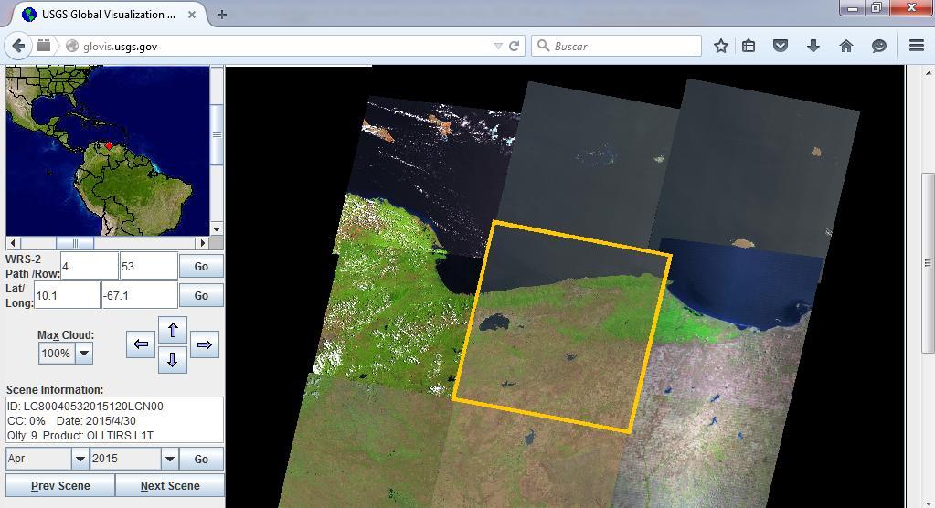
7 3.1 Methodology and Materials. Data source and processing: In this study, Landsat-8 L1T data provided by USGS with a track number LC was acquired in , with a temporal resolution of 16-days. Landsat-8 TIRS is one of the most accurate thermal infrared sensors with relatively high spatial resolutions at present. It has the capability to acquire information in two thermal infrared spectral bands of and 12.0 μm. Landsat 8 TIRS (Thermal Infrared Sensor) Band 10 and 11 and OLI (Operational Land Imaginer).Thermal constant K1 and K2 and other image statistic are obtain from metadata of the image file. For data preprocessing, four procedures were implemented with ERDAS IMAGINE 2014 and ARC GIS First, radiometric calibration and atmospheric correction were made to the OLI imagery. In this procedure, Digital Number (DN) values recorded by the sensor were converted into apparent reflectance and satellite brightness temperature for OLI-TIRS. Second, TIRS bands resampled in a 30-m resolution were reprojected from UTM/WGS1984 to LAT/LONG/WGS84, third, TIRS bands converted were integrated into a GIS with vectorial layers, of some relevant political and spatial information and finally NDVI analysis was done to compare LST patterns with NDVI results. Temperature from TIRS: The thermal TIRS bands 10 and 11 can be used to compute brightness temperature from radiance by inverting the Planck function. First of all, we need to convert the original DNs of TIRS into Top of Atmospheric Radiance (TOAr).Therefore, the original digital numbers (DN) of Landsat 8 TIR bands are converted into radiance based on the methods provided by Chander and Markham (2003) and the Landsat 8 Science Data Users Handbook (2015). The following equation 1 is used to convert original DNs into TOAr as shown below: TOAr = M * DN+B (eq.1) Where: M is the Radiance Multiplier and B is the Radiance Add The M, B values are in the metadata file of Landsat 8 data. The radiometric calibration of thermal band 10 and Landsat 8 was done using following K1, K2 constants: Metadata of Landsat 8- TIR-Band 10 Radiance Multiplier(M) Radiance Add(B) 0.1 K K
8 T = After we have got the TOAr values, TIRS band data can be converted from spectral radiance to brightness temperature, equation 2 (Landsat 8 Science Data Users Handbook, 2015) using the thermal constants provided in the metadata file: K2 ln( K1 +1) (eq. 2) Lλ where: T = At-satellite brightness temperature (K) Lλ = TOA spectral radiance (Watts/( m2 * srad * μm)) K1 = Band-specific thermal conversion constant from the metadata (K1_CONSTANT_BAND_x, where x is the band number, 10 or 11) K2 = Band-specific thermal conversion constant from the metadata (K2_CONSTANT_BAND_x, where x is the band number, 10 or 11). By using K1 and K2 parameters, we have converted the TOAr values into temperature in degrees kelvin. After this stage, we need to convert the unit of the temperature values into Fahrenheit or Celsius. This can be done by subtracting from the degrees kelvin. Though Landsat 8 TIRS has two thermal bands (10 and 11), only data from Band 10 are suitable at the moment for LST retrieval, due to the larger uncertainty in the Band 11 values (Barsi,J.A et all, 2014). Therefore, it was necessary to use a mono-window algorithm in the following form for LST retrieval from the Landsat 8 TIRS Band 10 data ( Wang.F et all, 2015): Ts = [a10(1 C10 D10) + (b10(1 C10 D10) + C10 + D10)T10 D10Ta]/C10 where: Ts is the LST retrieved from the Landsat 8 TIRS Band 10 data; Ta is the effective mean atmospheric temperature; T10 is the brightness temperature of Landsat 8 TIRS Band 10; a10 and b10 are the constants used to approximate the derivative of the Planck radiance function (Wang.F et all, 2015). After complete the radiometric calibration and atmospheric correction, geometric corrections were developed in order to reproject the TIRS bands resampled in a 30-m resolution, from UTM /WGS 1984 to LAT /LONG /WGS84 to match the vectorial layer availables.
.")
9 3.2. Results and discussion GIS data, such as topographic variables, were first integrated in remote sensing natural mapping studies, because satellite data did not provide sufficient detail for effective management resource (Rogan, J., Miller, J., Wulder, M. A., & Franklin, S. E., 2006). The same happen in the case of urban climate studies, remote sensing did not provide sufficient detail for effective management for urban planners. Traditional studies about heat urban island has low spatial resolution, that barely shows the urban sprawl phenomena, and general differences in LST between urban and peri urban areas (Fig.2). Fig.2 Metropolitan area of Caracas city. Low spatial resolution, (a) B10 Landsat 8, (b) and LST. Red square shows the resample area.
.")
10 Comparative analysis of Landsat 7 ETM+ surface temperature for 24 cities shows, consistent relationships between surface temperature and vegetation. ( Small, 2006). Low spatial resolution studies.

11 Médium resolution studies
12
13
, it is possible to increase the information recover in the LST analysis.")

14 Using geometric and resampling techniques, and integrating this information into a GIS (Fig.3), it is possible to increase the information recover in the LST analysis. This method allows urban planner to visualize and understand the differences between urban sectors, and associate these differences to urban land use and urban construction materials. Fig. 3 Example of GIS showing resampled area (a) and with vectorial layers of city streets in Caracas city(b). (a) (b)

15 Caracas city. Land surface temperatures patterns + municipalities limits

16 Caracas city. Land surface temperatures patterns + municipalities limits+ streets, roads.

17 Caracas city. North area. Land surface temperatures patterns + municipalities limits+ streets, roads.

18 Chacao Municipality: Local surface temperature patterns

19 Chacao Municipality: Local surface temperature patterns + Roughnees

20 Chacao Municipality: Local surface temperature patterns helps to define LCZs LCZ 3 D LCZ 6 LCZ 2 D LCZ3 LCZ2 Compact midrise Compact low rise Low plants LCZ6 Open Low rise
21 3.3 Conclusions: Integration of GIS data with remotely sensed imagery has increased interest because increased data availability, quality, and decreased data costs across large study extents. This methodology, also demonstrated the potential of data integration/fusion, for urban change mapping. In urban heat island studies, downscaling techniques combine with layers of roads, streets, buildings, into a GIS, can help to explain the differences in urban surface temperatures patterns, medium spatial resolution is been used more frequently in urban heat island and urban climate analysis.
22 References. Barsi, Julia A.; Schott, John R.; Hook, Simon J.; Raqueno, Nina G.; Markham, Brian L.; Radocinski, Robert G., (2014). Landsat-8 Thermal Infrared Sensor (TIRS) Vicarious Radiometric Calibration. Remote Sens. 6, no. 11: Chander, G., & Markham, B. (2003). Revised Landsat-5 TM radiometric calibration procedures and postcalibration dynamic ranges. Geoscience and Remote Sensing, IEEE Transactions on, 41(11), Cordova, Karenia (2011). Urban Climate News. ISSUE Nª. 39 MARCH Online: Cristóbal, J.; Ninyerola, M.; Pons, X. Modeling air temperature through a combination of remote sensing and GIS data. J. Geophys. Res. 2008, 113, doi: /2007jd Jimenez-Munoz, J. C., Sobrino, J., Skokovic, D., Mattar, C., & Cristobal, J. (2014). Land surface temperature retrieval methods from Landsat-8 thermal infrared sensor data. Geoscience and Remote Sensing Letters, IEEE, 11(10), Rogan, J., Miller, J., Wulder, M. A., & Franklin, S. E. (2006). Integrating GIS and remotely sensed data for mapping forest disturbance and change. Understanding forest disturbance and spatial pattern: remote sensing and GIS approaches, Rozenstein, O.; Qin, Z.; Derimian, Y.; Karnieli, A (2014). Derivation of land surface temperature for Landsat-8 TIRS using a split window algorithm. Sensors 14, U.S.Geological Survey (2015) LANDSAT 8 (L8) DATA USERS HANDBOOK, Version 1.0, June, online: Voogt, J. A., & Oke, T. R. (2003). Thermal remote sensing of urban climates. Remote sensing of environment, 86(3), Wang, F., Qin, Z., Song, C., Tu, L., Karnieli, A., & Zhao, S. (2015). An Improved Mono-Window Algorithm for Land Surface Temperature Retrieval from Landsat 8 Thermal Infrared Sensor Data. Remote Sensing, 7(4), Yu, X., Guo, X., & Wu, Z. (2014). Land Surface Temperature Retrieval from Landsat 8 TIRS Comparison between Radiative Transfer Equation- Based Method, Split Window Algorithm and Single Channel Method. Remote Sensing, 6(10),

23 Embajada de Francia 30 Al 31 de Octubre de 2014 Desafíos climáticos de hoy para el planeta del mañana. Diálogo Internacional Thank You So Much by your attention Dra. Karenia Córdova Sáez. Profa. Investigadora del Instituto de Geografía y Desarrollo Regional, IGDR /FHE /UCV kareniac@gmail.com
MONITORING THE SURFACE HEAT ISLAND (SHI) EFFECTS OF INDUSTRIAL ENTERPRISES
 EFFECTS OF INDUSTRIAL ENTERPRISES") MONITORING THE SURFACE HEAT ISLAND (SHI) EFFECTS OF INDUSTRIAL ENTERPRISES A. Şekertekin a, *, Ş. H. Kutoglu a, S. Kaya b, A. M. Marangoz a a BEU, Engineering Faculty, Geomatics Engineering Department
MONITORING THE SURFACE HEAT ISLAND (SHI) EFFECTS OF INDUSTRIAL ENTERPRISES A. Şekertekin a, *, Ş. H. Kutoglu a, S. Kaya b, A. M. Marangoz a a BEU, Engineering Faculty, Geomatics Engineering Department
Automatic Surface Temperature Mapping in ArcGIS using Landsat-8 TIRS and ENVI Tools Case Study: Al Habbaniyah Lake
 Automatic Surface Temperature Mapping in ArcGIS using Landsat-8 TIRS and ENVI Tools Case Study: Al Habbaniyah Lake Maher Ibrahim Sameen *, Mohammed Ahmed Al Kubaisy Universiti Putra Malaysia Selangor-Malaysia
COMPARISON OF NOAA/AVHRR AND LANDSAT/TM DATA IN TERMS OF RESEARCH APPLICATIONS ON THERMAL CONDITIONS IN URBAN AREAS
 COMPARISON OF NOAA/AVHRR AND LANDSAT/TM DATA IN TERMS OF RESEARCH APPLICATIONS ON THERMAL CONDITIONS IN URBAN AREAS Monika J. Hajto 1 *, Jakub P. Walawender 2,3 and Piotr Struzik 2 1 Department of Air
1. Introduction. Chaithanya, V.V. 1, Binoy, B.V. 2, Vinod, T.R. 2. Publication Date: 8 April DOI: https://doi.org/ /cloud.ijarsg.
 Cloud Publications International Journal of Advanced Remote Sensing and GIS 2017, Volume 6, Issue 1, pp. 2088-2096 ISSN 2320 0243, Crossref: 10.23953/cloud.ijarsg.112 Research Article Open Access Estimation
Comparison between Land Surface Temperature Retrieval Using Classification Based Emissivity and NDVI Based Emissivity
 Comparison between Land Surface Temperature Retrieval Using Classification Based Emissivity and NDVI Based Emissivity Isabel C. Perez Hoyos NOAA Crest, City College of New York, CUNY, 160 Convent Avenue,
Monitoring Vegetation Growth of Spectrally Landsat Satellite Imagery ETM+ 7 & TM 5 for Western Region of Iraq by Using Remote Sensing Techniques.
 Monitoring Vegetation Growth of Spectrally Landsat Satellite Imagery ETM+ 7 & TM 5 for Western Region of Iraq by Using Remote Sensing Techniques. Fouad K. Mashee, Ahmed A. Zaeen & Gheidaa S. Hadi Remote
Research Article A Quantitative Assessment of Surface Urban Heat Islands Using Satellite Multitemporal Data over Abeokuta, Nigeria
 International Atmospheric Sciences Volume 2016, Article ID 3170789, 6 pages http://dx.doi.org/10.1155/2016/3170789 Research Article A Quantitative Assessment of Surface Urban Heat Islands Using Satellite
Estimation of Land Surface Temperature of Kumta Taluk Using Remote Sensing and GIS Techniques
 Estimation of Land Surface Temperature of Kumta Taluk Using Remote Sensing and GIS Techniques Dr. A.G Koppad 1 and Malini P.J 2 Research Associate, NISAR Project (NRM) COF SIRSI, UAS Dharwad Professor
Remote sensing Based Assessment of Urban Heat Island Phenomenon in Nagpur Metropolitan Area
 International Journal of Information & Computation Technology. ISSN 0974-2239 Volume 4, Number 11 (2014), pp. 1069-1074 International Research Publications House http://www. irphouse.com Remote sensing
LAND USE LAND COVER, CHANGE DETECTION OF FOREST IN KARWAR TALUK USING GEO-SPATIAL TECHNIQUES
 LAND USE LAND COVER, CHANGE DETECTION OF FOREST IN KARWAR TALUK USING GEO-SPATIAL TECHNIQUES Dr. A.G Koppad 1, Malini P.J 2 Professor and University Head (NRM) COF SIRSI, UAS DHARWAD Research Associate,
Thermal Infrared (TIR) Remote Sensing: Challenges in Hot Spot Detection
 Remote Sensing: Challenges in Hot Spot Detection") Thermal Infrared (TIR) Remote Sensing: Challenges in Hot Spot Detection ASF Seminar Series Anupma Prakash Day : Tuesday Date : March 9, 2004 Time : 2.00 pm to 2.30 pm Place : GI Auditorium Geophysical
Thermal Infrared (TIR) Remote Sensing: Challenges in Hot Spot Detection ASF Seminar Series Anupma Prakash Day : Tuesday Date : March 9, 2004 Time : 2.00 pm to 2.30 pm Place : GI Auditorium Geophysical
SPATIAL GEOTECHNOLOGY APPLIED TO URBAN CLIMATE STUDIES: THERMAL ANALYSIS OF URBAN SURFACE AND URBAN LAND USE IN CARACAS CITY.
 SPATIAL GEOTECHNOLOGY APPLIED TO URBAN CLIMATE STUDIES: THERMAL ANALYSIS OF URBAN SURFACE AND URBAN LAND USE IN CARACAS CITY. Karenia Córdova Institute of Geography and Regional Development, Area of Energy
International Journal of Scientific & Engineering Research, Volume 4, Issue 12, December-2013 ISSN
 International Journal of Scientific & Engineering Research, Volume 4, Issue 12, December-2013 144 Assessment of Seasonal Variation of Land Surface Temperature (LST) in an Urban Area Arun Mondal1, Deepak
DEPENDENCE OF URBAN TEMPERATURE ELEVATION ON LAND COVER TYPES. Ping CHEN, Soo Chin LIEW and Leong Keong KWOH
 DEPENDENCE OF URBAN TEMPERATURE ELEVATION ON LAND COVER TYPES Ping CHEN, Soo Chin LIEW and Leong Keong KWOH Centre for Remote Imaging, Sensing and Processing, National University of Singapore, Lower Kent
Applications of GIS and Remote Sensing for Analysis of Urban Heat Island
 Chuanxin Zhu Professor Peter V. August Professor Yeqiao Wang NRS 509 December 15, 2016 Applications of GIS and Remote Sensing for Analysis of Urban Heat Island Since the last century, the global mean surface
Geographical Information System Tool Monitoring the Environmental Impact of Tangier Industrial Zones
 VOLUME 5 NO 4, 2017 Geographical Information System Tool Monitoring the Environmental Impact of Tangier Industrial Zones Boutaina Sebbah, Miriam Wahbi, Mustapha Maâtouk Department of Geology, Faculty of
Evaluation of Land Surface Temperature and Vegetation Relation Based on Landsat TM5 Data
 SCIREA Journal of Geosciences http://www.scirea.org/journal/geosciences October 15, 2016 Volume 1, Issue1, October 2016 Evaluation of Land Surface Temperature and Vegetation Relation Based on Landsat TM5
AssessmentofUrbanHeatIslandUHIusingRemoteSensingandGIS
 Global Journal of HUMANSOCIAL SCIENCE: B Geography, GeoSciences, Environmental Science & Disaster Management Volume 16 Issue 2 Version 1.0 Type: Double Blind Peer Reviewed International Research Journal
Journal of American Science 2017;13(12)
") Land Surface Temperature Retrieval of Landsat-8 Data Using Split Window Algorithm-A Case Study of Mosul District Amal Muhammad Saleh College of Agriculture /University of Baghdad geetakh@gmail.com Abstract:
Land Surface Temperature Retrieval of Landsat-8 Data Using Split Window Algorithm-A Case Study of Mosul District Amal Muhammad Saleh College of Agriculture /University of Baghdad geetakh@gmail.com Abstract:
Drought Estimation Maps by Means of Multidate Landsat Fused Images
 Remote Sensing for Science, Education, Rainer Reuter (Editor) and Natural and Cultural Heritage EARSeL, 2010 Drought Estimation Maps by Means of Multidate Landsat Fused Images Diego RENZA, Estíbaliz MARTINEZ,
AGRICULTURE DROUGHT AND FOREST FIRE MONITORING IN CHONGQING CITY WITH MODIS AND METEOROLOGICAL OBSERVATIONS *
 AGRICULTURE DROUGHT AND FOREST FIRE MONITORING IN CHONGQING CITY WITH MODIS AND METEOROLOGICAL OBSERVATIONS * HONGRUI ZHAO a ZHONGSHI TANG a, BIN YANG b AND MING ZHAO a a 3S Centre, Tsinghua University,
GIS GIS ETM+
 GIS 1388 Vol.1, No.1, Spring 2009 39-56 GIS Iranian Remote Sensing & GIS ETM+ *4 3 2 1 GIS -1-2 -3 GIS -4 88/8/9 : 88/4/30 :.. ). (.... ( ). ETM+. (LSU)...V_I_S : Email: soodabeh_namdari@yahoo.com 22431788
Abstract: Introduction: 10 th ESRI India User Conference 2009 Geography in Action
 Mitigation of Thermal Pollution to enhance urban air quality through Remote Sensing and GIS Anshu Gupta, Lecturer, Centre of Remote Sensing and GIS, MANIT, Bhopal, E- mail: anshugupta20002001@gmail.com
Time Series Analysis with SAR & Optical Satellite Data
 Time Series Analysis with SAR & Optical Satellite Data Thomas Bahr ESRI European User Conference Thursday October 2015 harris.com Motivation Changes in land surface characteristics mirror a multitude of
Study of Urban heat Island Effect on Ahmedabad City and Its Relationship with Urbanization and Vegetation Parameters
 Study of Urban heat Island Effect on Ahmedabad City and Its Relationship with Urbanization and Vegetation Parameters Aneesh Mathew a,*, Rishabh Chaudhary a, Neha Gupta a, a Research Scholar, Department
AATSR derived Land Surface Temperature from heterogeneous areas.
 AATSR derived Land Surface Temperature from heterogeneous areas. Guillem Sòria, José A. Sobrino Global Change Unit, Department of Thermodynamics, Faculty of Physics, University of Valencia, Av Dr. Moliner,
Critical review of the Climate Change Impact on urban areas by assessment of Heat Island effect
 Critical review of the Climate Change Impact on urban areas by assessment of Heat Island effect Case of Pune, India Town Planning, Civil Department Prof. Omkar Parishwad, ogp.civil@coep.ac.in Climate Change
Characterization of Surface Heat Fluxes over Heterogeneous Areas Using Landsat 8 Data for Urban Planning Studies
 Centre for Research on Settlements and Urbanism Journal of Settlements and Spatial Planning J o u r n a l h o m e p a g e: http://jssp.reviste.ubbcluj.ro Characterization of Surface Heat Fluxes over Heterogeneous
Remote Sensing Based Inversion of Gap Fraction for Determination of Leaf Area Index. Alemu Gonsamo 1 and Petri Pellikka 1
 Remote Sensing Based Inversion of Gap Fraction for Determination of Leaf Area Index Alemu Gonsamo and Petri Pellikka Department of Geography, University of Helsinki, P.O. Box, FIN- Helsinki, Finland; +-()--;
Results of the ESA-DUE UHI project
 13/12/2011 Results of the ESA-DUE UHI project Bino Maiheu (bino.maiheu@vito.be), on behalf of the UHI project Outline» Urban heat island problem» The ESA-DUE urban heat island project» UHI air temperature
Temperature and Emissivity from AHS data in the framework of the AGRISAR and EAGLE campaigns
 AGRISAR and EAGLE Campaigns Final Workshop 15-16 October 2007 (ESA/ESTEC, Noordwijk, The Netherlands) Temperature and Emissivity from AHS data in the framework of the AGRISAR and EAGLE campaigns J. A.
International Journal of Multidisciplinary Research and Modern Education (IJMRME) ISSN (Online): ( Volume I, Issue
 ISSN (Online): ( Volume I, Issue") ESTIMATE THE TEMPERATURE OF AN-NAJAF CITY BY USING REMOTE SENSING TECHNIQUES AND SATELLITE IMAGES Watheq F Shneen Remote Sensing Centre, University of Kufa, Iraq Abstract: The temperature is of high importance
ESTIMATE THE TEMPERATURE OF AN-NAJAF CITY BY USING REMOTE SENSING TECHNIQUES AND SATELLITE IMAGES Watheq F Shneen Remote Sensing Centre, University of Kufa, Iraq Abstract: The temperature is of high importance
THE ADVANCED Spaceborne Thermal Emission and
 60 IEEE GEOSCIENCE AND REMOTE SENSING LETTERS, VOL. 4, NO. 1, JANUARY 2007 Feasibility of Retrieving Land-Surface Temperature From ASTER TIR Bands Using Two-Channel Algorithms: A Case Study of Agricultural
ENERGY IN THE URBAN ENVIRONMENT: USE OF TERRA/ASTER IMAGERY AS A TOOL IN URBAN PLANNING N. CHRYSOULAKIS*
 ENERGY IN THE URBAN ENVIRONMENT: USE OF TERRA/ASTER IMAGERY AS A TOOL IN URBAN PLANNING N. CHRYSOULAKIS* Foundation for Research and Technology Hellas, Institute of Applied and Computational Mathematics,
The relationship between land cover changes and spatial-temporal dynamics of land surface temperature
 76 The relationship between land cover changes and spatial-temporal dynamics of land surface temperature Samereh Falahatkar 1, Seyed Mohsen Hosseini 2 and Ali Reza Soffianian 3 1 Academic center for education,
Land Surface Temperature Measurements From the Split Window Channels of the NOAA 7 Advanced Very High Resolution Radiometer John C.
 Land Surface Temperature Measurements From the Split Window Channels of the NOAA 7 Advanced Very High Resolution Radiometer John C. Price Published in the Journal of Geophysical Research, 1984 Presented
A NOVEL CONFIDENCE METRIC APPROACH FOR A LANDSAT LAND SURFACE TEMPERATURE PRODUCT INTRODUCTION
 A NOVEL CONFIDENCE METRIC APPROACH FOR A LANDSAT LAND SURFACE TEMPERATURE PRODUCT Monica J. Cook and Dr. John R. Schott Rochester Institute of Technology Chester F. Carlson Center for Imaging Science Digital
Digital Change Detection Using Remotely Sensed Data for Monitoring Green Space Destruction in Tabriz
 Int. J. Environ. Res. 1 (1): 35-41, Winter 2007 ISSN:1735-6865 Graduate Faculty of Environment University of Tehran Digital Change Detection Using Remotely Sensed Data for Monitoring Green Space Destruction
Super-resolution of MTSAT Land Surface Temperature by Blending MODIS and AVNIR2
 Super-resolution of MTSAT Land Surface Temperature by Blending MODIS and AVNIR2 Wataru Takeuchi 1*, Kei Oyoshi 2 and Shin Akatsuka 3 1 Institute of Industrial Science, University of Tokyo, Japan (6-1,
Analysis of Urban Surface Biophysical Descriptors and Land Surface Temperature Variations in Jimeta City, Nigeria
 Global Journal of Human Social Science Vol. 10 Issue 1 (Ver 1.0), April 2010 Page 19 Analysis of Urban Surface Biophysical Descriptors and Land Surface Temperature Variations in Jimeta City, Nigeria Ambrose
Land Surface Temperature Analysis in an Urbanising Landscape through Multi- Resolution Data
 Land Surface Temperature Analysis in an Urbanising Landscape through Multi- Resolution Data Ramachandra T. V. 1,2,3 *, Bharath H. Aithal 1,2, Durgappa Sanna D. 2 1 Energy & Wetlands Research Group, Centre
GMES: calibration of remote sensing datasets
 GMES: calibration of remote sensing datasets Jeremy Morley Dept. Geomatic Engineering jmorley@ge.ucl.ac.uk December 2006 Outline Role of calibration & validation in remote sensing Types of calibration
VISUALIZATION URBAN SPATIAL GROWTH OF DESERT CITIES FROM SATELLITE IMAGERY: A PRELIMINARY STUDY
 CO-439 VISUALIZATION URBAN SPATIAL GROWTH OF DESERT CITIES FROM SATELLITE IMAGERY: A PRELIMINARY STUDY YANG X. Florida State University, TALLAHASSEE, FLORIDA, UNITED STATES ABSTRACT Desert cities, particularly
Vegetation Change Detection of Central part of Nepal using Landsat TM
 Vegetation Change Detection of Central part of Nepal using Landsat TM Kalpana G. Bastakoti Department of Geography, University of Calgary, kalpanagb@gmail.com Abstract This paper presents a study of detecting
Estimation of Wavelet Based Spatially Enhanced Evapotranspiration Using Energy Balance Approach
 Estimation of Wavelet Based Spatially Enhanced Evapotranspiration Using Energy Balance Approach Dr.Gowri 1 Dr.Thirumalaivasan 2 1 Associate Professor, Jerusalem College of Engineering, Department of Civil
AATSR DERIVED LAND SURFACE TEMPERATURE OVER A HETEROGENEOUS REGION
 AATSR DERIVED LAND SURFACE TEMPERATURE OVER A HETEROGENEOUS REGION José A. Sobrino (1), Guillem Sòria (1), Juan C. Jiménez- Muñoz (1), Belen Franch (1), Victoria Hidalgo (1) and Elizabeth Noyes (2). (1)
ASSESSING THE IMPACT OF URBANIZATION ON URBAN CLIMATE BY REMOTE SENSING PERSPECTIVE: A CASE STUDY IN DANANG CITY, VIETNAM
 ASSESSING THE IMPACT OF URBANIZATION ON URBAN CLIMATE BY REMOTE SENSING PERSPECTIVE: A CASE STUDY IN DANANG CITY, VIETNAM Nguyen Hoang Khanh Linh a,*, Huynh Van Chuong a a Faculty of Land Resources and
REMOTE SENSING AND GIS AS POLLUTION MODEL VALIDATION AND EMISSION ASSESSMENT TOOLS. Athens, Athens, Greece
 REMOTE SENSING AND GIS AS POLLUTION MODEL VALIDATION AND EMISSION ASSESSMENT TOOLS Michael Petrakis 1, Theodora Kopania 1, David Briggs 2, Asbjorn Aaheim 3, Gerard Hoek 4, Gavin Shaddick 5, Adrianos Retalis
Introduction to Satellite Derived Vegetation Indices
 Introduction to the Use of Geospatial Information Technology for Drought Risk Management 13-17 November, 2017 Tonle Bassac II Restaurant, Phnom Penh, Cambodia Introduction to Satellite Derived Vegetation
Assessing Drought in Agricultural Area of central U.S. with the MODIS sensor
 Assessing Drought in Agricultural Area of central U.S. with the MODIS sensor Di Wu George Mason University Oct 17 th, 2012 Introduction: Drought is one of the major natural hazards which has devastating
ASSESSING THERMAL RISK IN URBAN AREAS AN APPLICATION FOR THE URBAN AGGLOMERATION OF ATHENS
 ASSESSING THERMAL RISK IN URBAN AREAS AN APPLICATION FOR THE URBAN AGGLOMERATION OF ATHENS Polydoros T. and Cartalis C. Department of Environmental Physics, University of Athens, University Campus, Build
1. Introduction. Jai Kumar, Paras Talwar and Krishna A.P. Department of Remote Sensing, Birla Institute of Technology, Ranchi, Jharkhand, India
 Cloud Publications International Journal of Advanced Remote Sensing and GIS 2015, Volume 4, Issue 1, pp. 1026-1032, Article ID Tech-393 ISSN 2320-0243 Research Article Open Access Forest Canopy Density
DETECTION OF CHANGES IN FOREST LANDCOVER TYPE AFTER FIRES IN PORTUGAL
 DETECTION OF CHANGES IN FOREST LANDCOVER TYPE AFTER FIRES IN PORTUGAL Paulo M. Barbosa, Mário R. Caetano, and Teresa G. Santos Centro Nacional de Informação Geográfica (CNIG), Portugal barp@cnig.pt, mario@cnig.pt,
Land Surface Temperature in the EUMETSAT LSA SAF: Current Service and Perspectives. Isabel Trigo
 Land Surface Temperature in the EUMETSAT LSA SAF: Current Service and Perspectives Isabel Trigo Outline EUMETSAT Land-SAF: Land Surface Temperature Geostationary Service SEVIRI Polar-Orbiter AVHRR/Metop
PREDICTION OF FUTURE LAND USE LAND COVER CHANGES OF VIJAYAWADA CITY USING REMOTE SENSING AND GIS
 PREDICTION OF FUTURE LAND USE LAND COVER CHANGES OF VIJAYAWADA CITY USING REMOTE SENSING AND GIS K. Sundara Kumar 1 *, N V A Sai Sankar Valasala 2, J V Subrahmanyam V 3, Mounika Mallampati 4 Kowsharajaha
METRIC tm. Mapping Evapotranspiration at high Resolution with Internalized Calibration. Shifa Dinesh
 METRIC tm Mapping Evapotranspiration at high Resolution with Internalized Calibration Shifa Dinesh Outline Introduction Background of METRIC tm Surface Energy Balance Image Processing Estimation of Energy
Investigating Urban Heat Island Estimation and Relation between Various Land Cover Indices in Tehran City Using Landsat 8 Imagery
 OPEN ACCESS Conference Proceedings Paper Remote Sensing Investigating Urban Heat Island Estimation and Relation between Various Land Cover Indices in Tehran City Using Landsat 8 Imagery Mahdi Hasanlou
Dynamical Monitoring and Evaluation Methods to Urban Heat Island Effects Based on RS&GIS
 Available online at www.sciencedirect.com Procedia Environmental Sciences 10 (2011 ) 1228 1237 Procedia 2011 Environmental 3rd International Sciences 00 Conference (2011) 000 000 on Environmental Science
Monitoring Sea Surface temperature change at the Caribbean Sea, using AVHRR images. Y. Santiago Pérez, and R. Mendez Yulfo
 Monitoring Sea Surface temperature change at the Caribbean Sea, using AVHRR images. Y. Santiago Pérez, and R. Mendez Yulfo Department of Geology, University of Puerto Rico Mayagüez Campus, P.O. Box 9017,
CORRELATION BETWEEN URBAN HEAT ISLAND EFFECT AND THE THERMAL INERTIA USING ASTER DATA IN BEIJING, CHINA
 CORRELATION BETWEEN URBAN HEAT ISLAND EFFECT AND THE THERMAL INERTIA USING ASTER DATA IN BEIJING, CHINA Yurong CHEN a, *, Mingyi DU a, Rentao DONG b a School of Geomatics and Urban Information, Beijing
Using MERIS and MODIS for Land Cover Mapping in the Netherlands
 Using MERIS and for Land Cover Mapping in the Netherlands Raul Zurita Milla, Michael Schaepman and Jan Clevers Wageningen University, Centre for Geo-Information, NL Introduction Actual and reliable information
Estimation of evapotranspiration using satellite TOA radiances Jian Peng
 Estimation of evapotranspiration using satellite TOA radiances Jian Peng Max Planck Institute for Meteorology Hamburg, Germany Satellite top of atmosphere radiances Slide: 2 / 31 Surface temperature/vegetation
An Automated Object-Oriented Satellite Image Classification Method Integrating the FAO Land Cover Classification System (LCCS).
.") An Automated Object-Oriented Satellite Image Classification Method Integrating the FAO Land Cover Classification System (LCCS). Ruvimbo Gamanya Sibanda Prof. Dr. Philippe De Maeyer Prof. Dr. Morgan De
An Automated Object-Oriented Satellite Image Classification Method Integrating the FAO Land Cover Classification System (LCCS). Ruvimbo Gamanya Sibanda Prof. Dr. Philippe De Maeyer Prof. Dr. Morgan De
APPLICATION OF LAND CHANGE MODELER FOR PREDICTION OF FUTURE LAND USE LAND COVER A CASE STUDY OF VIJAYAWADA CITY
 APPLICATION OF LAND CHANGE MODELER FOR PREDICTION OF FUTURE LAND USE LAND COVER A CASE STUDY OF VIJAYAWADA CITY K. Sundara Kumar 1, Dr. P. Udaya Bhaskar 2, Dr. K. Padmakumari 3 1 Research Scholar, 2,3
An Algorithm for Retrieving Land Surface Temperatures Using VIIRS Data in Combination with Multi-Sensors
 Sensors 2014, 14, 21385-21408; doi:10.3390/s141121385 Article OPEN ACCESS sensors ISSN 1424-8220 www.mdpi.com/journal/sensors An Algorithm for Retrieving Land Surface Temperatures Using VIIRS Data in Combination
Impact of Landuse Change on Surface Temperature in Ibadan, Nigeria Abegunde Linda, Adedeji Oluwatola
 Impact of Landuse Change on Surface Temperature in Ibadan, Nigeria Abegunde Linda, Adedeji Oluwatola Abstract It has become an increasing evident that large development influences the climate. There are
Tracking On-orbit Radiometric Accuracy and Stability of Suomi NPP VIIRS using Extended Low Latitude SNOs
 Tracking On-orbit Radiometric Accuracy and Stability of Suomi NPP VIIRS using Extended Low Latitude SNOs Sirish Uprety a Changyong Cao b Slawomir Blonski c Xi Shao c Frank Padula d a CIRA, Colorado State
Land Surface Temperature Retrieval from MODIS Data by Integrating Regression Models and the Genetic Algorithm in an Arid Region
 Remote Sens. 2014, 6, 5344-5367; doi:10.3390/rs6065344 Article OPEN ACCESS remote sensing ISSN 2072-4292 www.mdpi.com/journal/remotesensing Land Surface Temperature Retrieval from MODIS Data by Integrating
Determination of Urban Thermal Characteristics on an Urban/Rural Land Cover Gradient Using Remotely Sensed Data
 South African Journal of Geomatics, Vol. 4, No. 4, November 2015 Determination of Urban Thermal Characteristics on an Urban/Rural Land Cover Gradient Using Remotely Sensed Data Sithole, K, Odindi, J. O.*
Mario Flores, Graduate Student Department of Applied Mathematics, UTSA. EES 5053: Remote Sensing
 Mario Flores, Graduate Student Department of Applied Mathematics, UTSA Miguel Balderas, E.I.T., Graduate Student Department of Civil/Environmental Engineering, UTSA EES 5053: Remote Sensing REMOTE SENSING
Impact of the Human Activities on the Local Climate and Environment of the Suez City in Egypt
 International Journal of Geosciences, 2014, 5, 700-709 Published Online June 2014 in SciRes. http://www.scirp.org/journal/ijg http://dx.doi.org/10.4236/ijg.2014.57063 Impact of the Human Activities on
THERMAL REMOTE SENSING TECHNIQUES FOR STUDYING EARTHQUAKE ANOMALIES IN 2013 BALOCHISTAN EARTHQUAKES. G. Kaplan 1 and U. Avdan 2
 THERMAL REMOTE SENSING TECHNIQUES FOR STUDYING EARTHQUAKE ANOMALIES IN 2013 BALOCHISTAN EARTHQUAKES ABSTRACT: G. Kaplan 1 and U. Avdan 2 1 PhD Candidate, GIS and Remote Sensing program, Anadolu University,
Preparation of LULC map from GE images for GIS based Urban Hydrological Modeling
 International Conference on Modeling Tools for Sustainable Water Resources Management Department of Civil Engineering, Indian Institute of Technology Hyderabad: 28-29 December 2014 Abstract Preparation
ESTIMATION OF ATMOSPHERIC COLUMN AND NEAR SURFACE WATER VAPOR CONTENT USING THE RADIANCE VALUES OF MODIS
 ESTIMATION OF ATMOSPHERIC COLUMN AND NEAR SURFACE WATER VAPOR CONTENT USIN THE RADIANCE VALUES OF MODIS M. Moradizadeh a,, M. Momeni b, M.R. Saradjian a a Remote Sensing Division, Centre of Excellence
This is trial version
 Journal of Rangeland Science, 2012, Vol. 2, No. 2 J. Barkhordari and T. Vardanian/ 459 Contents available at ISC and SID Journal homepage: www.rangeland.ir Full Paper Article: Using Post-Classification
USE OF LANDSAT IMAGERY FOR EVALUATION OF LAND COVER / LAND USE CHANGES FOR A 30 YEAR PERIOD FOR THE LAKE ERIE WATERSHED
 USE OF LANDSAT IMAGERY FOR EVALUATION OF LAND COVER / LAND USE CHANGES FOR A 30 YEAR PERIOD FOR THE LAKE ERIE WATERSHED Mark E. Seidelmann Carolyn J. Merry Dept. of Civil and Environmental Engineering
Retrievals of Land surface temperature using LANDSAT8 and ASTER data over Italian volcanic areas: comparison of satellites and in situ measurements
 Retrievals of Land surface temperature using LANDSAT8 and ASTER data over Italian volcanic areas: comparison of satellites and in situ measurements M.F. Buongiorno, M. Silvestri, M. Musacchio Istituto
Land Surface Processes and Land Use Change. Lex Comber
 Land Surface Processes and Land Use Change Lex Comber ajc36@le.ac.uk Land Surface Processes and Land Use Change Geographic objects in GIS databases Detecting land use change using multitemporal imaging
Cross-calibration of Geostationary Satellite Visible-channel Imagers Using the Moon as a Common Reference
 Cross-calibration of Geostationary Satellite Visible-channel Imagers Using the Moon as a Common Reference Thomas C. Stone U.S. Geological Survey, Flagstaff AZ, USA 27 30 August, 2012 Motivation The archives
International Journal on Emerging Technologies 8(1): (2017) ISSN No. (Print) : ISSN No. (Online) :
: (2017) ISSN No. (Print) : ISSN No. (Online) :") e t International Journal on Emerging Technologies 8(1): 553-559(2017) ISSN No. (Print) : 0975-8364 ISSN No. (Online) : 2249-3255 Critical Review of the Climate Change Impact on Urban Areas by Assessment
e t International Journal on Emerging Technologies 8(1): 553-559(2017) ISSN No. (Print) : 0975-8364 ISSN No. (Online) : 2249-3255 Critical Review of the Climate Change Impact on Urban Areas by Assessment
Percentage of Vegetation Cover Change Monitoring in Wuhan Region Based on Remote Sensing
 Available online at www.sciencedirect.com Procedia Environmental Sciences 10 (2011 ) 1466 1472 2011 3rd International Conference on Environmental Science and Information Conference Application Title Technology
Atmospheric correction of HJ1-A/B images and the effects on remote sensing monitoring of cyanobacteria bloom
 Remote Sensing and GIS for Hydrology and Water Resources (IAHS Publ. 368, 2015) (Proceedings RSHS14 and ICGRHWE14, Guangzhou, China, August 2014). 69 Atmospheric correction of HJ1-A/B images and the effects
COMBINED METHODS OF THERMAL REMOTE SENSING AND MOBILE CLIMATE TRANSECTS IN BEER SHEVA, ISRAEL
 COMBINED METHODS OF THERMAL REMOTE SENSING AND MOBILE CLIMATE TRANSECTS IN BEER SHEVA, ISRAEL C. Beeson a,, D. Blumberg b, A. Brazel c, L. Shashua-Bar d a Department of Geography, University of British
Estimation of ocean contribution at the MODIS near-infrared wavelengths along the east coast of the U.S.: Two case studies
 GEOPHYSICAL RESEARCH LETTERS, VOL. 32, L13606, doi:10.1029/2005gl022917, 2005 Estimation of ocean contribution at the MODIS near-infrared wavelengths along the east coast of the U.S.: Two case studies
Land cover/land use mapping and cha Mongolian plateau using remote sens. Title. Author(s) Bagan, Hasi; Yamagata, Yoshiki. Citation Japan.
 Bagan, Hasi; Yamagata, Yoshiki. Citation Japan.") Title Land cover/land use mapping and cha Mongolian plateau using remote sens Author(s) Bagan, Hasi; Yamagata, Yoshiki International Symposium on "The Imp Citation Region Specific Systems". 6 Nove Japan.
Title Land cover/land use mapping and cha Mongolian plateau using remote sens Author(s) Bagan, Hasi; Yamagata, Yoshiki International Symposium on "The Imp Citation Region Specific Systems". 6 Nove Japan.
KNOWLEDGE-BASED CLASSIFICATION OF LAND COVER FOR THE QUALITY ASSESSEMENT OF GIS DATABASE. Israel -
 KNOWLEDGE-BASED CLASSIFICATION OF LAND COVER FOR THE QUALITY ASSESSEMENT OF GIS DATABASE Ammatzia Peled a,*, Michael Gilichinsky b a University of Haifa, Department of Geography and Environmental Studies,
An Internet-based Agricultural Land Use Trends Visualization System (AgLuT)
") An Internet-based Agricultural Land Use Trends Visualization System (AgLuT) Prepared for Missouri Department of Natural Resources Missouri Department of Conservation 07-01-2000-12-31-2001 Submitted by
An Internet-based Agricultural Land Use Trends Visualization System (AgLuT) Prepared for Missouri Department of Natural Resources Missouri Department of Conservation 07-01-2000-12-31-2001 Submitted by
Characterizing fractional vegetation cover and land surface temperature based on sub- pixel fractional impervious surfaces from Landsat TM/ETM+
 1 2 Characterizing fractional vegetation cover and land surface temperature based on sub- pixel fractional impervious surfaces from Landsat TM/ETM+ 3 4 Youshui Zhang a, b, *, Angela Harris a, Heiko Balzter
Overview of Remote Sensing in Natural Resources Mapping
 Overview of Remote Sensing in Natural Resources Mapping What is remote sensing? Why remote sensing? Examples of remote sensing in natural resources mapping Class goals What is Remote Sensing A remote sensing
SSRG International Journal of Geo informatics and Geological Science (SSRG-IJGGS) Volume 4 Issue 3 Sep to Dec 2017
 Volume 4 Issue 3 Sep to Dec 2017") Evaluation of the Relationship between Land Use/Land Cover Dynamics and Land Surface Temperature across the Niger Delta Region of Nigeria Aniekan Eyoh 1, Francis Okeke 2 Department of Geoinformatics &
Evaluation of the Relationship between Land Use/Land Cover Dynamics and Land Surface Temperature across the Niger Delta Region of Nigeria Aniekan Eyoh 1, Francis Okeke 2 Department of Geoinformatics &
INTERNATIONAL JOURNAL OF GEOMATICS AND GEOSCIENCES Volume 2, No 1, 2011
 INTERNATIONAL JOURNAL OF GEOMATICS AND GEOSCIENCES Volume 2, No 1, 2011 Copyright 2010 All rights reserved Integrated Publishing services Research article ISSN 0976 4380 Spatio-Temporal changes of Land
Defining microclimates on Long Island using interannual surface temperature records from satellite imagery
 Defining microclimates on Long Island using interannual surface temperature records from satellite imagery Deanne Rogers*, Katherine Schwarting, and Gilbert Hanson Dept. of Geosciences, Stony Brook University,
Classification of High Spatial Resolution Remote Sensing Images Based on Decision Fusion
 Journal of Advances in Information Technology Vol. 8, No. 1, February 2017 Classification of High Spatial Resolution Remote Sensing Images Based on Decision Fusion Guizhou Wang Institute of Remote Sensing
LAND SURFACE TEMPERATURE CHANGE AFTER CONSTRUCTION OF THE KOZJAK DAM BASED ON REMOTE SENSING DATA
 LAND SURFACE TEMPERATURE CHANGE AFTER CONSTRUCTION OF THE KOZJAK DAM BASED ON REMOTE SENSING DATA DOI: http://dx.doi.org/10.18509/gbp.2016.02 UDC: 627.82:551.525.2]:528.85(497.782) MSc. Gordana JOVANOVSKA
URBAN CHANGE DETECTION OF LAHORE (PAKISTAN) USING A TIME SERIES OF SATELLITE IMAGES SINCE 1972
 USING A TIME SERIES OF SATELLITE IMAGES SINCE 1972") URBAN CHANGE DETECTION OF LAHORE (PAKISTAN) USING A TIME SERIES OF SATELLITE IMAGES SINCE 1972 Omar Riaz Department of Earth Sciences, University of Sargodha, Sargodha, PAKISTAN. omarriazpk@gmail.com ABSTRACT
URBAN CHANGE DETECTION OF LAHORE (PAKISTAN) USING A TIME SERIES OF SATELLITE IMAGES SINCE 1972 Omar Riaz Department of Earth Sciences, University of Sargodha, Sargodha, PAKISTAN. omarriazpk@gmail.com ABSTRACT
Use of Corona, Landsat TM, Spot 5 images to assess 40 years of land use/cover changes in Cavusbasi
 New Strategies for European Remote Sensing, Olui (ed.) 2005 Millpress, Rotterdam, ISBN 90 5966 003 X Use of Corona, Landsat TM, Spot 5 images to assess 40 years of land use/cover changes in Cavusbasi N.
Learning Objectives. Thermal Remote Sensing. Thermal = Emitted Infrared
 November 2014 lava flow on Kilauea (USGS Volcano Observatory) (http://hvo.wr.usgs.gov) Landsat-based thermal change of Nisyros Island (volcanic) Thermal Remote Sensing Distinguishing materials on the ground
DETECTION AND ANALYSIS OF LAND-USE/LAND-COVER CHANGES IN NAY PYI TAW, MYANMAR USING SATELLITE REMOTE SENSING IMAGES
 DETECTION AND ANALYSIS OF LAND-USE/LAND-COVER CHANGES IN NAY PYI TAW, MYANMAR USING SATELLITE REMOTE SENSING IMAGES Kay Khaing Oo 1, Eiji Nawata 1, Kiyoshi Torii 2 and Ke-Sheng Cheng 3 1 Division of Environmental
Monitoring influence of urbanization on urban thermal environment using multi-temporal LANDSAT imagery: application to Da Nang city
 Vietnam Journal of Earth Sciences 37 (2015) 318-327 (VAST) Vietnam Academy of Science and Technology Vietnam Journal of Earth Sciences Website: http://www.vjs.ac.vn/index.php/jse Monitoring influence of
Proceedings Combining Water Indices for Water and Background Threshold in Landsat Image
 Proceedings Combining Water Indices for Water and Background Threshold in Landsat Image Tri Dev Acharya 1, Anoj Subedi 2, In Tae Yang 1 and Dong Ha Lee 1, * 1 Department of Civil Engineering, Kangwon National