Temperature and Emissivity from AHS data in the framework of the AGRISAR and EAGLE campaigns
|
|
|
- Augustine Cameron Parks
- 5 years ago
- Views:
Transcription
 Temperature and Emissivity from AHS data in the framework of the AGRISAR and EAGLE")

1 AGRISAR and EAGLE Campaigns Final Workshop October 2007 (ESA/ESTEC, Noordwijk, The Netherlands) Temperature and Emissivity from AHS data in the framework of the AGRISAR and EAGLE campaigns J. A. Sobrino, J.C. Jiménez nez-muñoz, V. Hidalgo, A. Barella-Ortiz, G. Sòria, M. Romaguera and B. Franch Global Change Unit Dpt. of Earth Physics and Thermodynamics Faculty of Physics University of Valencia

2 PRESENTATION SCHEME 1. OBJECTIVES 2. METHODOLOGY 3. ON-GROUND CALIBRATION OF AHS TIR BANDS 4. LAND SURFACE TEMPERATURE/EMISSIVITY RETRIEVAL 5. SIMPLIFIED METHOD FOR ET RETRIEVAL 6. EFFECTS OF CLOUDS/SHADOWS: BRIEF ANALYSIS 7. CONCLUSIONS
3 1. OBJECTIVES MAIN OBJECTIVES To produce Land Surface Temperature (LST) validated products from AHS data. To solve energy budget equation to produce EvapoTranspiration (ET) products from AHS data using a simple and operative methodology. SECONDARY OBJECTIVES To produce Land Surface Emissivity (LSE) products from AHS data. Analysis of Emissivity spectra over high spectral contrast areas. Effects of Clouds and Shadows on our measurements.
4 1. OBJECTIVES 2. METHODOLOGY 3. ON-GROUND CALIBRATION OF AHS TIR BANDS 4. LAND SURFACE TEMPERATURE/EMISSIVITY RETRIEVAL 5. SIMPLIFIED METHOD FOR ET RETRIEVAL 6. EFFECTS OF CLOUDS/SHADOWS: BRIEF ANALYSIS 7. CONCLUSIONS


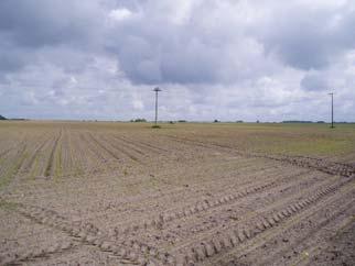


5 2. METHODOLOGY TEST AREA: AGRISAR Maize (P222) Barley (P200) Wheat (P250) Rape (P140) Grass (P823)

6 2. METHODOLOGY TEST AREA: EAGLE


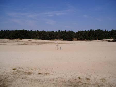
7 2. METHODOLOGY TEST AREA: EAGLE Speulderbos forest Sand (Kootwijk)


8 2. METHODOLOGY EQUIPMENT Thermal radiometers: CIMEL CE 312-1& 1& 2 Raytek ST Raytek MID OPTRIS MiniSight Plus EVEREST 4000 Calibration sources: GALAI 204-P EVEREST 1000 Thermal camera: NEC TH9100 pro Masts and Tripods to place the radiometers
9 2. METHODOLOGY MAIN RADIOMETERS CIMEL (4 & 6 bands) Temperature Range: -80 to +50 ºC Operating Environment: -20 to +50 ºC Resolution: 8 mk (broadband) 50 mk (other bands) (at 20 ºC) Response time: 1 s Field of view: 10 º Readout data: Local display. Transferable on PC

10 2. METHODOLOGY... also thermal images Thermal camera NEC TH9100 pro Spectral Pass-Band: Single Band: 8-14 μm Temperature Range: -40 to +120 ºC Sensitivity: 0.08 K Field of view: 21º x 16º Other characteristics: Adjustable emissivity. Visible image can be acquired
11 2. METHODOLOGY MEASUREMENT OF LAND SURFACE TEMPERATURE Radiometric temperatures measured directly with the thermal radiometer need to be transformed into LST: emissivity (ε) + downwelling atmospheric radiance (L atm ) correction surface i L = ε B ( T ) + (1 ε ) L i i s i atm (i: thermal band of the radiometer) L surface : directly measured by the radiometer L surface =B(T rad ) L atm : measured with the radiometer pointing to the sky ε: TES algorithm applied to field measurements This correction is specially important over areas with low emissivity
 Emissivity=0.")
12 2. METHODOLOGY Some examples of measured values Vegetated plot, with high emissivity Differences between LST and Trad = 0.5 ºC P140 (Rape) Emissivity=0.99 Radiometric Corrected (LST) AGRISAR Temperature (ºC) :06 12:07 13:07 14:08 15:08 16:09 17:09 18:10 Local Time
13 2. METHODOLOGY Some examples of measured values Bare soil plot, with low emissivity Differences between LST and Trad = 4 ºC P222 (Soil/Corn) Emissivity=0.916 AGRISAR Temperature (ºC) Radiometric Corrected (LST) 15 9:50 10:04 10:19 10:33 10:48 11:02 11:16 11:31 11:45 12:00 Local Time
 CIMEL6b (9-JUNE) 8.")
 0.80 8.0 8.5 9.0 9.5 10.0 10.5 11.0 11.5 12.0 Wavelength (microns)")
14 2. METHODOLOGY Some examples of measured values: Emissivity Spectra Soil in P222 Emissivity CIMEL6b (8-JUNE) CIMEL6b (9-JUNE) Wavelength (microns) Asphalt Emissivity CIMEL6b (5-JULY) Wavelength (microns)

15 2. METHODOLOGY Some examples of measured values EAGLE 13-June-2006 Sand High spectral contrast
 8 7 7 Difference around 2 K when wind speed is near to 0.")
16 2. METHODOLOGY Some examples of measured values EAGLE Speulderbos forest Differences between nadir (R1) and 50º (R3). Influence of wind speed R1-R3 Windspeed(m/s) Difference around 2 K when wind speed is near to 0. T (K) Windspeed (m/s) :29 12:59 13:29 13:59 14:29 14:59 Time


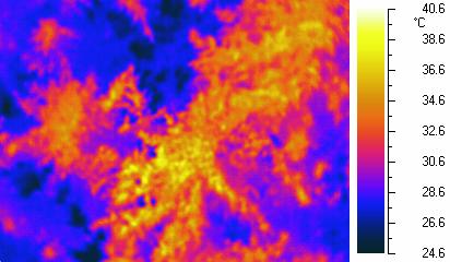
17 2. METHODOLOGY Thermal Camera Some examples of measured values 12:32 LT, u=1.15m/s 14:45 LT, u=0.82m/s Differences in time 14:45 (local time) 12:32 (local time)

18 2. METHODOLOGY Thermal Video Composite From 10:30 to 16:30 (local time) 1 image/minute We can observe thermal fluctuations and thermal homogeneization due to the effect of wind
19
 Satellite altitude (700 km) atmospheric transmissivity 0.8 0.6 0.4 0.2 BAND 71 ( 8.18 μm) BAND 72 ( 8.66 μm) BAND 73 ( 9.15 μm) BAND 74 ( 9.")
20 2. METHODOLOGY THERMAL AIRBORNE IMAGERY: AHS Operated by INTA Our Interest: Port 4, 10 TIR bands (71-80) Low flight (975 m) Satellite altitude (700 km) atmospheric transmissivity BAND 71 ( 8.18 μm) BAND 72 ( 8.66 μm) BAND 73 ( 9.15 μm) BAND 74 ( 9.60 μm) BAND 75 (10.07 μm) BAND 76 (10.59 μm) BAND 77 (11.18 μm) BAND 78 (11.78 μm) BAND 79 (12.35 μm) BAND 80 (12.93 μm) wavelength ( m) Bands 71, 74, 80: Absorption Regions A priori bands for LST retrieval: 72, to 79
21 2. METHODOLOGY AHS DATABASE AGRISAR 06-JUNE (12 flights) 10-JUNE (06 flights) 04-JULY (12 flights but only 4 images with IGM files) 05-JULY (12 flights) Total: 42 images EAGLE 13-JUNE (13 flights) Total AGRISAR+EAGLE: 55 images Field measurements are available for all the flights
22 1. OBJECTIVES 2. METHODOLOGY 3. ON-GROUND CALIBRATION OF AHS TIR BANDS 4. LAND SURFACE TEMPERATURE/EMISSIVITY RETRIEVAL 5. SIMPLIFIED METHOD FOR ET RETRIEVAL 6. EFFECTS OF CLOUDS/SHADOWS: BRIEF ANALYSIS 7. CONCLUSIONS
23 3. ON-GROUND CALIBRATION The predicted at-sensor radiance (or brightness temperature) for each AHS band (using field measurements and MODTRAN) has been compared with the AHS measured radiance. Theoretical Basis: Temperature-Based Method L F i = ε B( Ts) + (1 ε ) τ + π at sensor i i i i i L i ε: surface emissivity B: Planck function T s : surface kinetic temperature (LST) F : atmospheric downwelling irradiance τ: atmospheric transmissivity L : path radiance (Each spectral magnitud is convolved using the AHS filter functions) T s : measured in situ ε i : measured in situ or extracted from spectral libraries τ, F, L : calculated from atmospheric soundings and MODTRAN-4 No atmospheric sounding was available on 6-June-2006 MODIS products
24 3. ON-GROUND CALIBRATION Results obtained for the AGRISAR database P140 (Rape) Comparison in terms of brightness temperature (AHS values have been extracted for 3x3 pixels)
25 3. ON-GROUND CALIBRATION P140 (Rape) Problems for AHS band 78 were found in these particular flights (P01CD and P03CD) FINAL RESULT: RMSE = 1.5 K
26 3. ON-GROUND CALIBRATION P250 (Wheat Bowen Station)
27 3. ON-GROUND CALIBRATION P250 (Wheat Bowen Station)
28 3. ON-GROUND CALIBRATION P250 (Wheat Bowen Station)
29 3. ON-GROUND CALIBRATION P222 (Soil/Corn) FINAL RESULT: RMSE = 1.5 K
30 3. ON-GROUND CALIBRATION P823 (Grass) FINAL RESULT: RMSE = 1.3 K
31 3. ON-GROUND CALIBRATION P200 (Barley)
32 3. ON-GROUND CALIBRATION P200 (Barley) FINAL RESULT: RMSE = 0.9 K
33 3. ON-GROUND CALIBRATION ANALYSIS BY BAND
34 3. ON-GROUND CALIBRATION All bands show similar RMSE 1 K OVERALL RMSE 1.1 K
35 1. OBJECTIVES 2. METHODOLOGY 3. ON-GROUND CALIBRATION OF AHS TIR BANDS 4. LAND SURFACE TEMPERATURE/EMISSIVITY RETRIEVAL 5. SIMPLIFIED METHOD FOR ET RETRIEVAL 6. EFFECTS OF CLOUDS/SHADOWS: BRIEF ANALYSIS 7. CONCLUSIONS
36 4. LST/LSE RETRIEVAL Methods for LST retrieval (based on the Radiative Transfer Equation): SINGLE-CHANNEL (1 thermal band) SPLIT-WINDOW (2 thermal bands) A priori knowledge of emissivity is required, which is the major disadvantage of these methods. Over well-known areas emissivity can be estimated from NDVI. TEMPERATURE/EMISSIVITY SEPARATION (TES) It requires multispectral TIR data (at least 4 thermal bands). It provides simultaneously surface temperature and emissivity, which is the main advantage of this algorithm. TES has been used to obtain the LST products. Problems in emissivity retrieval over areas with low spectral contrast (water, vegetation), and it is very sensitive to atmospheric correction.
37 4. LST/LSE RETRIEVAL TES algorithm (Gillespie et al., 1998: IEEE Trans. Geosci. Rem. Sens.) Atm. Correc. L surface, L NEM (iterative procedure) Ts=max(T i ) ε initial AHS bands: 72,73,75,76 77,78,79 RATIO β-spectrum (normalized ε) (Note that it can be also applied to field measurements made with a multiband radiometer) Coefficients a, b, c obtained from ASTER spectral library MMD ε min =a+bmmd c (semi-empirical) Result: Ts, ε i
38 4. LST/LSE RETRIEVAL LST VALIDATION FROM FIELD MEASUREMENTS (AGRISAR) 53 test points RMSE < 1.9 K
39 4. LST/LSE RETRIEVAL LST VALIDATION FROM FIELD MEASUREMENTS (EAGLE) LOW FLIGHT (975 m AGL) Bias (K) st dev (K) RMSE (K) CIMEL4b CAMERA HIGH FLIGHT (2745 m AGL) Bias (K) st dev (K) RMSE (K) CIMEL4b CAMERA


40 4. LST/LSE RETRIEVAL Examples of LST maps EAGLE AGRISAR
41 4. LST/LSE RETRIEVAL LST PRODUCT PROVIDED BY INTA (level 2b) Obtained from ATCOR-4 software Single-channel method using AHS band 74 Problems found: LST is lower than at-sensor brightness temperature. Validation from field measurements shows RMSE = 4.7 K
42 4. LST/LSE RETRIEVAL RESULTS FOR LAND SURFACE EMISSIVITY RETRIEVAL Problems related to the emissivity spectra retrieval from multispectral TIR data: TES is very sensitive to atmospheric correction. Not all the surface acomplish the relationship between ε min and MMD. Problems over low-mmd surfaces, but it can be partly solved assuming ε min = AGRISAR: vegetated areas, high vegetation cover (P140 and P250)
43 4. LST/LSE RETRIEVAL AREAS WITH HIGH SPECTRAL CONTRAST: acceptable results Direct comparison between CIMEL-2 bands 5, 4, 3, 2 and AHS bands 72, 73, 76, 77 RMSE = Emissivity P222 (Soil/Corn) MMD= AHS In-Situ Wavelenght (microns)


44 4. LST/LSE RETRIEVAL EAGLE: Sand site (high spectral contrast) High bias probably due to angular effects or problems in thedynamicrangeofahs TIR bands Emissivity In-Situ AHS-TES Wavelength (μm)
45 1. OBJECTIVES 2. METHODOLOGY 3. ON-GROUND CALIBRATION OF AHS TIR BANDS 4. LAND SURFACE TEMPERATURE/EMISSIVITY RETRIEVAL 5. SIMPLIFIED METHOD FOR ET RETRIEVAL 6. EFFECTS OF CLOUDS/SHADOWS: BRIEF ANALYSIS 7. CONCLUSIONS
46 5. EVAPOTRANSPIRATION EVAPOTRANSPIRATION - Knowledge of ET allows the irrigation water use optimization (hydrological cycle). - Direct estimation of ET by solving the energy balance equation requires TIR data. ET Retrieval from high-resolution data: Sobrino et al. (2005), A simple algorithm to estimate evapotranspiration from DAIS data: Application to the DAISEX campaigns, Journal of Hydrology, 315: Gómez et al. (2005), Retrieval of evapotranspiration over the Alpilles/ReSeDA experimental site using airborne POLDER sensor and a thermal camera, Remote Sensing of Environment, 96: The methodology is based in the S-SEBI model [Roerink et al. 2000, Phys. Chem. Earth (B), 25(2): ] Instantaneous ET: LET i = Λ i ( Rni Gi ) R ni : instanteneous net radiation G i : instantaneous soil heat flux Λ i : evaporative fraction Daily ET ET d = Λ C R L i di ni (Λ i Λ d, G d 0) C di R = R nd ni C di depends on the day of the year and time (Bastiaanssen 2000, Journal of Hydrology, 229:87-100)
47 5. EVAPOTRANSPIRATION Net Radiation flux: R = (1 α ) R + εr εσt 4 ni s sw lw S (σ: Stefan-Boltzman constant) R sw, R lw : incoming shortwave and longwave radiation Measured in-situ. ε, T s : land surface emissivity and temperature TES algorithm Surface Albedo (α s ): roughly estimated from at-surface reflectances provided by INTA (level 2b, using ATCOR-4) Soil Heat Flux: G = 0.5Rn exp( 2.13MSAVI) Evaporative Fraction: Λ= T T H H T T s LET (T H, T LET : temperatures graphically obtained from Ts versus albedo)
48 5. EVAPOTRANSPIRATION Some values in AGRISAR (P250, bowen station) DOY Local Time ETd (mm) σ (ETd) (mm) ETi (mmd -1 ) σ(eti) (mmd -1 ) : ETinst In situ (mmd -1 ) 13 Relative error (ETinst) 38% : % : % : % Some values in EAGLE (Speulderbos, Pine forest) Local time Flight Altitude ETd (mm) ETi (mmd -1 ) 12: m : m : m : m : m : m 6 12


49 5. EVAPOTRANSPIRATION Examples of ET maps AGRISAR 9:10 GMT EAGLE 12:32 GMT Daily Evapotranspiration (mm)
50 1. OBJECTIVES 2. METHODOLOGY 3. ON-GROUND CALIBRATION OF AHS TIR BANDS 4. LAND SURFACE TEMPERATURE/EMISSIVITY RETRIEVAL 5. SIMPLIFIED METHOD FOR ET RETRIEVAL 6. EFFECTS OF CLOUDS/SHADOWS: BRIEF ANALYSIS 7. CONCLUSIONS


51 6. CLOUDS/SHADOWS In previous campaigns (DAISEX, SPARC, SEN2FLEX) airborne imagery was acquired under clear-sky conditions. During AGRISAR, some measurements were affected by clouds/shadows:


52 6. CLOUDS/SHADOWS Values extracted from cloud pixels clearly provides wrong results. Pixels near clouds are somehow affected. Difficult interpretation.


53 6. CLOUDS/SHADOWS Simple test for Cloud masking: LST < 290 K and NDVI < 0.5 Percentage of shadows (obtained with ATCOR-4, M. Jiménez from INTA) It would be useful to have also cloud/shadows masking products!
54 1. OBJECTIVES 2. METHODOLOGY 3. ON-GROUND CALIBRATION OF AHS TIR BANDS 4. LAND SURFACE TEMPERATURE/EMISSIVITY RETRIEVAL 5. SIMPLIFIED METHOD FOR ET RETRIEVAL 6. EFFECTS OF CLOUDS/SHADOWS: BRIEF ANALYSIS 7. CONCLUSIONS
55 7. CONCLUSIONS A complete database of field measurements and airborne imagery was collected in the AGRISAR/EAGLE field campaigns. On-ground calibration of AHS TIR bands showed good results over land: Plots with high emissivity and vegetation cover: RMSE < 0.9 K Other plots (soil): RMSE < 1.5 K Overall RMSE: 1.1 K Land Surface Temperature products are available (validation over land shows a RMSE < 1.9 K) Land Surface Emissivity products are also available, but some problems can be found over areas with low MMD (however, in these cases one can assume near-blackbody behaviour ε 0.99). Evapotranspiration maps can be obtained from a simple methodology. These products require a deeper validation (and also comparison with other models).
An experimental study of angular variations of brightness surface temperature for some natural surfaces
 An experimental study of angular variations of brightness surface temperature for some natural surfaces Juan Cuenca, José A. Sobrino, and Guillem Soria University of Valencia, c./ Dr. Moliner 5, 46 Burjassot,
THERMAL MEASUREMENTS IN THE FRAMEWORK OF SPARC
 THERMAL MEASUREMENTS IN THE FRAMEWORK OF SPARC J.A. Sobrino (1), M. Romaguera (1), G. Sòria (1), M. M. Zaragoza (1), M. Gómez (1), J. Cuenca (1), Y. Julien (1), J.C. Jiménez-Muñoz (1), Z. Su (2), L. Jia
AATSR derived Land Surface Temperature from heterogeneous areas.
 AATSR derived Land Surface Temperature from heterogeneous areas. Guillem Sòria, José A. Sobrino Global Change Unit, Department of Thermodynamics, Faculty of Physics, University of Valencia, Av Dr. Moliner,
AN EXPERIMENTAL STUDY OF ANGULAR VARIATIONS OF BRIGHTNESS SURFACE TEMPERATURE FOR SOME NATURAL SURFACES
 AN EXPERIMENTAL STUDY OF ANGULAR VARIATIONS OF BRIGHTNESS SURFACE TEMPERATURE FOR SOME NATURAL SURFACES J. Cuenca, J. A. Sobrino, G. Sòria Global Change Unit Dpt. of Thermodynamics - University of Valencia
AATSR DERIVED LAND SURFACE TEMPERATURE OVER A HETEROGENEOUS REGION
 AATSR DERIVED LAND SURFACE TEMPERATURE OVER A HETEROGENEOUS REGION José A. Sobrino (1), Guillem Sòria (1), Juan C. Jiménez- Muñoz (1), Belen Franch (1), Victoria Hidalgo (1) and Elizabeth Noyes (2). (1)
Guillem Sòria, José A. Sobrino, Juan C. Jiménez-Muñoz, Mónica Gómez, Juan Cuenca, Mireia Romaguera and Malena Zaragoza
 Guillem Sòria, José A. Sobrino, Juan C. Jiménez-Muñoz, Mónica Gómez, Juan Cuenca, Mireia Romaguera and Malena Zaragoza University of Valencia, Spain MERIS (A)ATSR WORKSHOP ESRIN, Frascati, Italy 26-30
THE ADVANCED Spaceborne Thermal Emission and
 60 IEEE GEOSCIENCE AND REMOTE SENSING LETTERS, VOL. 4, NO. 1, JANUARY 2007 Feasibility of Retrieving Land-Surface Temperature From ASTER TIR Bands Using Two-Channel Algorithms: A Case Study of Agricultural
Field Emissivity Measurements during the ReSeDA Experiment
 Field Emissivity Measurements during the ReSeDA Experiment C. Coll, V. Caselles, E. Rubio, E. Valor and F. Sospedra Department of Thermodynamics, Faculty of Physics, University of Valencia, C/ Dr. Moliner
PLEASE SCROLL DOWN FOR ARTICLE
 This article was downloaded by: [Universidad de Valencia] On: 2 September 2008 Access details: Access Details: [subscription number 779262402] Publisher Taylor & Francis Informa Ltd Registered in England
Estimation of Wavelet Based Spatially Enhanced Evapotranspiration Using Energy Balance Approach
 Estimation of Wavelet Based Spatially Enhanced Evapotranspiration Using Energy Balance Approach Dr.Gowri 1 Dr.Thirumalaivasan 2 1 Associate Professor, Jerusalem College of Engineering, Department of Civil
Validation of Land Surface Temperatures derived from AATSR data at the Valencia Test Site
 Validation of Land Surface Temperatures derived from AATSR data at the Valencia Test Site César Coll, Vicente Caselles, Enric Valor, Raquel Niclòs, Juan M. Sánchez and Joan M. Galve Thermal Remote Sensing
Soil emissivity spectra for ground and remote sensing thermal calibration. J. A. Sobrino, C. Mattar,, S. Hook,, J. C. Jiménez
 Soil emissivity spectra for ground and remote sensing thermal calibration J. A. Sobrino, C. Mattar,, S. Hook,, J. C. Jiménez Global Change Unit, University of Valencia, Spain. Experimental Setup FTIR spectra
Fractional Vegetation Cover Estimation from PROBA/CHRIS Data: Methods, Analysis of Angular Effects and Application to the Land Surface Emissivity
 Fractional Vegetation Cover Estimation from PROBA/CHRIS Data: Methods, Analysis of Angular Effects and Application to the Land Surface Emissivity J.C. Jiménez-Muñoz 1, J.A. Sobrino 1, L. Guanter 2, J.
SAIL thermique, a model to simulate land surface emissivity (LSE) spectra
 spectra") SAIL thermique, a model to simulate land surface emissivity (LSE) spectra Albert Olioso, INRA, UMR EMMAH (INRA UAPV), Avignon, France Frédéric Jacob, Audrey Lesaignoux IRD, UMR LISAH, Montpellier, France
SAIL thermique, a model to simulate land surface emissivity (LSE) spectra Albert Olioso, INRA, UMR EMMAH (INRA UAPV), Avignon, France Frédéric Jacob, Audrey Lesaignoux IRD, UMR LISAH, Montpellier, France
METRIC tm. Mapping Evapotranspiration at high Resolution with Internalized Calibration. Shifa Dinesh
 METRIC tm Mapping Evapotranspiration at high Resolution with Internalized Calibration Shifa Dinesh Outline Introduction Background of METRIC tm Surface Energy Balance Image Processing Estimation of Energy
Estimating Temperature and Emissivity from the DAIS Instrument
 Estimating Temperature and Emissivity from the DAIS Instrument C. Coll 1, V. Caselles 1, E. Rubio 1, E. Valor 1, F. Sospedra 1, F. Baret 2 and. Prévot 2 1 Department of Thermodynamics, Faculty of Physics,
Mapping surface fluxes using Visible - Near Infrared and Thermal Infrared data with the SEBAL Algorithm
 Mapping surface fluxes using Visible - Near Infrared and Thermal Infrared data with the SEBAL Algorithm F. Jacob 1, A. Olioso 1, X.F. Gu 1, J.F. Hanocq 1, O. Hautecoeur 2, and M. Leroy 2 1 INRA bioclimatologie,
Blackbody radiation. Main Laws. Brightness temperature. 1. Concepts of a blackbody and thermodynamical equilibrium.
 Lecture 4 lackbody radiation. Main Laws. rightness temperature. Objectives: 1. Concepts of a blackbody, thermodynamical equilibrium, and local thermodynamical equilibrium.. Main laws: lackbody emission:
Land Surface Temperature Retrieval from MODIS Data by Integrating Regression Models and the Genetic Algorithm in an Arid Region
 Remote Sens. 2014, 6, 5344-5367; doi:10.3390/rs6065344 Article OPEN ACCESS remote sensing ISSN 2072-4292 www.mdpi.com/journal/remotesensing Land Surface Temperature Retrieval from MODIS Data by Integrating
ESTIMATION OF ATMOSPHERIC COLUMN AND NEAR SURFACE WATER VAPOR CONTENT USING THE RADIANCE VALUES OF MODIS
 ESTIMATION OF ATMOSPHERIC COLUMN AND NEAR SURFACE WATER VAPOR CONTENT USIN THE RADIANCE VALUES OF MODIS M. Moradizadeh a,, M. Momeni b, M.R. Saradjian a a Remote Sensing Division, Centre of Excellence
Using LST and SSE from Hyperspectral Thermal Infrared Airborne Data for Satellite Validation: Application to AisaOWL
 Using LST and SSE from Hyperspectral Thermal Infrared Airborne Data for Satellite Validation: Application to AisaOWL Mary Langsdale, Martin Wooster, Bruce Main, Daniel Fisher, Weidong Xu and Maniseng Sarrazy-Weston
Surface temperature what does this data tell us about micro-meteorological processes?
 Surface temperature what does this data tell us about micro-meteorological processes? Prof. Dr. Eberhard Parlow Meteorology, Climatology and Remote Sensing (MCR Lab) Department of Environmental Sciences
ENVISAT/AATSR derived land surface temperature over a heterogeneous region
 Available online at www.sciencedirect.com Remote Sensing of Environment 111 (2007) 409 422 www.elsevier.com/locate/rse ENVISAT/AATSR derived land surface temperature over a heterogeneous region Guillem
Hyperspectral Observations of Land Surfaces: Temperature & Emissivity
 Hyperspectral Observations of Land Surfaces: Temperature & Emissivity Isabel F. Trigo Contributions from: Frank Göttsche, Filipe Aires, Maxime Paul Outline Land Surface Temperature Products & Requirements
Learning Objectives. Thermal Remote Sensing. Thermal = Emitted Infrared
 November 2014 lava flow on Kilauea (USGS Volcano Observatory) (http://hvo.wr.usgs.gov) Landsat-based thermal change of Nisyros Island (volcanic) Thermal Remote Sensing Distinguishing materials on the ground
THE LAND-SAF SURFACE ALBEDO AND DOWNWELLING SHORTWAVE RADIATION FLUX PRODUCTS
 THE LAND-SAF SURFACE ALBEDO AND DOWNWELLING SHORTWAVE RADIATION FLUX PRODUCTS Bernhard Geiger, Dulce Lajas, Laurent Franchistéguy, Dominique Carrer, Jean-Louis Roujean, Siham Lanjeri, and Catherine Meurey
Lectures 7 and 8: 14, 16 Oct Sea Surface Temperature
 Lectures 7 and 8: 14, 16 Oct 2008 Sea Surface Temperature References: Martin, S., 2004, An Introduction to Ocean Remote Sensing, Cambridge University Press, 454 pp. Chapter 7. Robinson, I. S., 2004, Measuring
Isabel Trigo, Sandra Freitas, Carla Barroso, Isabel Monteiro, Pedro Viterbo
 Land Surface Temperature, Emissivity and Long-Wave Downwlling Fluxes from MSG Observations: current status and way forward Isabel Trigo, Sandra Freitas, Carla Barroso, Isabel Monteiro, Pedro Viterbo 1
ATMOS 5140 Lecture 7 Chapter 6
 ATMOS 5140 Lecture 7 Chapter 6 Thermal Emission Blackbody Radiation Planck s Function Wien s Displacement Law Stefan-Bolzmann Law Emissivity Greybody Approximation Kirchhoff s Law Brightness Temperature
APPLICATIONS WITH METEOROLOGICAL SATELLITES. W. Paul Menzel. Office of Research and Applications NOAA/NESDIS University of Wisconsin Madison, WI
 APPLICATIONS WITH METEOROLOGICAL SATELLITES by W. Paul Menzel Office of Research and Applications NOAA/NESDIS University of Wisconsin Madison, WI July 2004 Unpublished Work Copyright Pending TABLE OF CONTENTS
OSI SAF SST Products and Services
 OSI SAF SST Products and Services Pierre Le Borgne Météo-France/DP/CMS (With G. Legendre, A. Marsouin, S. Péré, S. Philippe, H. Roquet) 2 Outline Satellite IR radiometric measurements From Brightness Temperatures
Infrared continental surface emissivity spectra and skin temperature retrieved from IASI observation
 Infrared continental surface emissivity spectra and skin temperature retrieved from IASI observation Capelle V., Chédin A., Péquignot E., N. A Scott Schlüssel P., Newman S. IASI Conference 2013 Introduction
LAND SURFACE TEMPERATURE VALIDATION WITH IN SITU MEASUREMENTS
 LAND SURFACE TEMPERATURE VALIDATION WITH IN SITU MEASUREMENTS Group 7 Juan Manuel González Cantero Irene Grimaret Rincón Alex Webb Advisor: Darren Ghent Research problem The project task is to design an
METEOSAT SECOND GENERATION DATA FOR ASSESSMENT OF SURFACE MOISTURE STATUS
 METEOSAT SECOND GENERATION DATA FOR ASSESSMENT OF SURFACE MOISTURE STATUS Simon Stisen (1), Inge Sandholt (1), Rasmus Fensholt (1) (1) Institute of Geography, University of Copenhagen, Oestervoldgade 10,
Evaluation of the DART 3D model in the thermal domain using satellite/airborne imagery and ground-based measurements
 Evaluation of the DART 3D model in the thermal domain using satellite/airborne imagery and ground-based measurements J.A. Sobrino, C. Mattar, J.P. Gastellu-Etchegorry, J.C. Jimenez-Munoz, E. Grau To cite
Remote Sensing Applications for Land/Atmosphere: Earth Radiation Balance
 Remote Sensing Applications for Land/Atmosphere: Earth Radiation Balance - Introduction - Deriving surface energy balance fluxes from net radiation measurements - Estimation of surface net radiation from
MONITORING THE SURFACE HEAT ISLAND (SHI) EFFECTS OF INDUSTRIAL ENTERPRISES
 EFFECTS OF INDUSTRIAL ENTERPRISES") MONITORING THE SURFACE HEAT ISLAND (SHI) EFFECTS OF INDUSTRIAL ENTERPRISES A. Şekertekin a, *, Ş. H. Kutoglu a, S. Kaya b, A. M. Marangoz a a BEU, Engineering Faculty, Geomatics Engineering Department
MONITORING THE SURFACE HEAT ISLAND (SHI) EFFECTS OF INDUSTRIAL ENTERPRISES A. Şekertekin a, *, Ş. H. Kutoglu a, S. Kaya b, A. M. Marangoz a a BEU, Engineering Faculty, Geomatics Engineering Department
Land Surface Temperature in the EUMETSAT LSA SAF: Current Service and Perspectives. Isabel Trigo
 Land Surface Temperature in the EUMETSAT LSA SAF: Current Service and Perspectives Isabel Trigo Outline EUMETSAT Land-SAF: Land Surface Temperature Geostationary Service SEVIRI Polar-Orbiter AVHRR/Metop
Extraction of incident irradiance from LWIR hyperspectral imagery
 DRDC-RDDC-215-P14 Extraction of incident irradiance from LWIR hyperspectral imagery Pierre Lahaie, DRDC Valcartier 2459 De la Bravoure Road, Quebec, Qc, Canada ABSTRACT The atmospheric correction of thermal
Estimation and Validation of Land Surface Temperatures from Chinese Second-Generation Polar-Orbit FY-3A VIRR Data
 Remote Sens. 2015, 7, 3250-3273; doi:10.3390/rs70303250 Article OPEN ACCESS remote sensing ISSN 2072-4292 www.mdpi.com/journal/remotesensing Estimation and Validation of Land Surface Temperatures from
Retrievals of Land surface temperature using LANDSAT8 and ASTER data over Italian volcanic areas: comparison of satellites and in situ measurements
 Retrievals of Land surface temperature using LANDSAT8 and ASTER data over Italian volcanic areas: comparison of satellites and in situ measurements M.F. Buongiorno, M. Silvestri, M. Musacchio Istituto
Remote Sensing and Hydrology Using Thermal Infrared Sensors
 Remote Sensing and Hydrology Using Thermal Infrared Sensors J. van der Kwast & S.M. de Jong Faculty of Geosciences Utrecht University, the Netherlands Contents Introduction Theory of Thermal Remote Sensing
An Algorithm for Retrieving Land Surface Temperatures Using VIIRS Data in Combination with Multi-Sensors
 Sensors 2014, 14, 21385-21408; doi:10.3390/s141121385 Article OPEN ACCESS sensors ISSN 1424-8220 www.mdpi.com/journal/sensors An Algorithm for Retrieving Land Surface Temperatures Using VIIRS Data in Combination
Simulation and validation of land surface temperature algorithms for MODIS and AATSR data
 Tethys, 4, 27 32, 2007 www.tethys.cat ISSN-1697-1523 eissn-1139-3394 DOI:10.3369/tethys.2007.4.04 Journal edited by ACAM (Associació Catalana de Meteorologia) Simulation and validation of land surface
Estimation of broadband emissivity (8-12um) from ASTER data by using RM-NN
 from ASTER data by using RM-NN") Estimation of broadband emissivity (8-12um) from ASTER data by using RM-NN K. B. Mao, 1,2, 7 Y. Ma, 3, 8 X. Y. Shen, 4 B. P. Li, 5 C. Y. Li, 2 and Z. L. Li 6 1 Key Laboratory of Agri-informatics, MOA,
Estimation of broadband emissivity (8-12um) from ASTER data by using RM-NN K. B. Mao, 1,2, 7 Y. Ma, 3, 8 X. Y. Shen, 4 B. P. Li, 5 C. Y. Li, 2 and Z. L. Li 6 1 Key Laboratory of Agri-informatics, MOA,
Topics: Visible & Infrared Measurement Principal Radiation and the Planck Function Infrared Radiative Transfer Equation
 Review of Remote Sensing Fundamentals Allen Huang Cooperative Institute for Meteorological Satellite Studies Space Science & Engineering Center University of Wisconsin-Madison, USA Topics: Visible & Infrared
Radiation in the atmosphere
 Radiation in the atmosphere Flux and intensity Blackbody radiation in a nutshell Solar constant Interaction of radiation with matter Absorption of solar radiation Scattering Radiative transfer Irradiance
Land Surface Temperature Measurements From the Split Window Channels of the NOAA 7 Advanced Very High Resolution Radiometer John C.
 Land Surface Temperature Measurements From the Split Window Channels of the NOAA 7 Advanced Very High Resolution Radiometer John C. Price Published in the Journal of Geophysical Research, 1984 Presented
Analysing Land Surface Emissivity with Multispectral Thermal Infrared Data
 2nd Workshop on Remote Sensing and Modeling of Surface Properties 9-11 June 2009, Météo France, Toulouse, France Analysing Land Surface Emissivity with Multispectral Thermal Infrared Data Maria Mira, Thomas
Near Real-time Evapotranspiration Estimation Using Remote Sensing Data
 Near Real-time Evapotranspiration Estimation Using Remote Sensing Data by Qiuhong Tang 08 Aug 2007 Land surface hydrology group of UW Land Surface Hydrology Research Group ❶ ❷ ❸ ❹ Outline Introduction
Physical Basics of Remote-Sensing with Satellites
 - Physical Basics of Remote-Sensing with Satellites Dr. K. Dieter Klaes EUMETSAT Meteorological Division Am Kavalleriesand 31 D-64295 Darmstadt dieter.klaes@eumetsat.int Slide: 1 EUM/MET/VWG/09/0162 MET/DK
GMES: calibration of remote sensing datasets
 GMES: calibration of remote sensing datasets Jeremy Morley Dept. Geomatic Engineering jmorley@ge.ucl.ac.uk December 2006 Outline Role of calibration & validation in remote sensing Types of calibration
RADIOMETRIC INTERCALIBRATION OF MOMS AND SPOT BY VICARIOUS METHOD
 RADIOMETRIC INTERCALIBRATION OF MOMS AND SPOT BY VICARIOUS METHOD M. Schroeder, R. Müller, P. Reinartz German Aerospace Center, DLR Remote Sensing Technology Institute, Image Science P.O. Box 11 16 82234
COMPARISON OF NOAA/AVHRR AND LANDSAT/TM DATA IN TERMS OF RESEARCH APPLICATIONS ON THERMAL CONDITIONS IN URBAN AREAS
 COMPARISON OF NOAA/AVHRR AND LANDSAT/TM DATA IN TERMS OF RESEARCH APPLICATIONS ON THERMAL CONDITIONS IN URBAN AREAS Monika J. Hajto 1 *, Jakub P. Walawender 2,3 and Piotr Struzik 2 1 Department of Air
SATELLITE RETRIEVAL OF AEROSOL PROPERTIES OVER BRIGHT REFLECTING DESERT REGIONS
 SATELLITE RETRIEVAL OF AEROSOL PROPERTIES OVER BRIGHT REFLECTING DESERT REGIONS Tilman Dinter 1, W. von Hoyningen-Huene 1, A. Kokhanovsky 1, J.P. Burrows 1, and Mohammed Diouri 2 1 Institute of Environmental
May 3, :41 AOGS - AS 9in x 6in b951-v16-ch13 LAND SURFACE ENERGY BUDGET OVER THE TIBETAN PLATEAU BASED ON SATELLITE REMOTE SENSING DATA
 Advances in Geosciences Vol. 16: Atmospheric Science (2008) Eds. Jai Ho Oh et al. c World Scientific Publishing Company LAND SURFACE ENERGY BUDGET OVER THE TIBETAN PLATEAU BASED ON SATELLITE REMOTE SENSING
Evaluation of a MODIS Triangle-based Algorithm for Improving ET Estimates in the Northern Sierra Nevada Mountain Range
 Evaluation of a MODIS Triangle-based Algorithm for Improving ET Estimates in the Northern Sierra Nevada Mountain Range Kyle R. Knipper 1, Alicia M. Kinoshita 2, and Terri S. Hogue 1 January 5 th, 2015
Thermal remote sensing from Airborne Hyperspectral Scanner data in the framework of the SPARC and SEN2FLEX projects: an overview
 Hydrol. Earth Syst. Sci., 13, 2031 2037, 2009 Author(s) 2009. This work is distributed under the Creative Commons Attribution 3.0 License. Hydrology and Earth System Sciences Thermal remote sensing from
Application of a Land Surface Temperature Validation Protocol to AATSR data. Dar ren Ghent1, Fr ank Göttsche2, Folke Olesen2 & John Remedios1
 Application of a Land Surface Temperature Validation Protocol to AATSR data Dar ren Ghent1, Fr ank Göttsche, Folke Olesen & John Remedios1 1 E a r t h O b s e r v a t i o n S c i e n c e, D e p a r t m
The Two Source Energy Balance model using satellite, airborne and proximal remote sensing
 The using satellite, airborne and proximal remote sensing 7 years in a relationship Héctor Nieto Hector.nieto@irta.cat Resistance Energy Balance Models (REBM) E R e n H G Physics based on an analogy to
Surface emissivity retrieval from Digital Airborne Imaging Spectrometer data
 JOURNAL OF GEOPHYSICAL RESEARCH, VOL. 107, NO. D23, 4729, doi:10.1029/2002jd002197, 2002 Surface emissivity retrieval from Digital Airborne Imaging Spectrometer data José A. Sobrino and Juan C. Jiménez-Muñoz
Comparison between Land Surface Temperature Retrieval Using Classification Based Emissivity and NDVI Based Emissivity
 Comparison between Land Surface Temperature Retrieval Using Classification Based Emissivity and NDVI Based Emissivity Isabel C. Perez Hoyos NOAA Crest, City College of New York, CUNY, 160 Convent Avenue,
Lecture 3A: Interception
 3-1 GEOG415 Lecture 3A: Interception What is interception? Canopy interception (C) Litter interception (L) Interception ( I = C + L ) Precipitation (P) Throughfall (T) Stemflow (S) Net precipitation (R)
Chapter 4 Nadir looking UV measurement. Part-I: Theory and algorithm
 Chapter 4 Nadir looking UV measurement. Part-I: Theory and algorithm -Aerosol and tropospheric ozone retrieval method using continuous UV spectra- Atmospheric composition measurements from satellites are
ENERGY IN THE URBAN ENVIRONMENT: USE OF TERRA/ASTER IMAGERY AS A TOOL IN URBAN PLANNING N. CHRYSOULAKIS*
 ENERGY IN THE URBAN ENVIRONMENT: USE OF TERRA/ASTER IMAGERY AS A TOOL IN URBAN PLANNING N. CHRYSOULAKIS* Foundation for Research and Technology Hellas, Institute of Applied and Computational Mathematics,
The Spectral Radiative Effects of Inhomogeneous Clouds and Aerosols
 The Spectral Radiative Effects of Inhomogeneous Clouds and Aerosols S. Schmidt, B. Kindel, & P. Pilewskie Laboratory for Atmospheric and Space Physics University of Colorado SORCE Science Meeting, 13-16
Radiative Transfer in the Atmosphere
 Radiative Transfer in the Atmosphere Lectures in Brienza 19 Sep 2011 Paul Menzel UW/CIMSS/AOS Outline Radiation Definitions Planck Function Emission, Absorption, Scattering Radiative Transfer Equation
9/5/16. Section 3-4: Radiation, Energy, Climate. Common Forms of Energy Transfer in Climate. Electromagnetic radiation.
 Section 3-4: Radiation, Energy, Climate Learning outcomes types of energy important to the climate system Earth energy balance (top of atm., surface) greenhouse effect natural and anthropogenic forcings
Mapping Surface Broadband Emissivity of the Sahara Desert Using ASTER and MODIS Data
 Earth Interactions Volume 8 (2004) Paper No. 7 Page 1 Copyright Ó 2004, Paper 8-007; 4,089 words, 7 Figures, 0 Animations, 3 Tables. http://earthinteractions.org Mapping Surface Broadband Emissivity of
An Optimization Algorithm for Separating Land Surface Temperature and Emissivity from Multispectral Thermal Infrared Imagery
 264 IEEE TRANSACTIONS ON GEOSCIENCE AND REMOTE SENSING, VOL. 39, NO. 2, FEBRUARY 2001 An Optimization Algorithm for Separating Land Surface Temperature and Emissivity from Multispectral Thermal Infrared
A high spectral resolution global land surface infrared emissivity database
 A high spectral resolution global land surface infrared emissivity database Eva E. Borbas, Robert O. Knuteson, Suzanne W. Seemann, Elisabeth Weisz, Leslie Moy, and Hung-Lung Huang Space Science and Engineering
What is it good for? RT is a key part of remote sensing and climate modeling.
 Read Bohren and Clothiaux Ch.; Ch 4.-4. Thomas and Stamnes, Ch..-.6; 4.3.-4.3. Radiative Transfer Applications What is it good for? RT is a key part of remote sensing and climate modeling. Remote sensing:
Evaluation of SEBAL Model for Evapotranspiration Mapping in Iraq Using Remote Sensing and GIS
 Evaluation of SEBAL Model for Evapotranspiration Mapping in Iraq Using Remote Sensing and GIS Hussein Sabah Jaber* Department of Civil Engineering, University Putra Malaysia, 43400 UPM Serdang, Selangor,
Radiation, Sensible Heat Flux and Evapotranspiration
 Radiation, Sensible Heat Flux and Evapotranspiration Climatological and hydrological field work Figure 1: Estimate of the Earth s annual and global mean energy balance. Over the long term, the incoming
An Overview of the Radiation Budget in the Lower Atmosphere
 An Overview of the Radiation Budget in the Lower Atmosphere atmospheric extinction irradiance at surface P. Pilewskie 300 University of Colorado Laboratory for Atmospheric and Space Physics Department
Radiation in climate models.
 Lecture. Radiation in climate models. Objectives:. A hierarchy of the climate models.. Radiative and radiative-convective equilibrium.. Examples of simple energy balance models.. Radiation in the atmospheric
ASSESSMENT OF ALGORITHMS FOR LAND SURFACE ANALYSIS DOWN-WELLING LONG-WAVE RADIATION AT THE SURFACE
 ASSESSMENT OF ALGORITHMS FOR LAND SURFACE ANALYSIS DOWN-WELLING LONG-WAVE RADIATION AT THE SURFACE Isabel F. Trigo, Carla Barroso, Sandra C. Freitas, Pedro Viterbo Instituto de Meteorologia, Rua C- Aeroporto,
Friday 8 September, :00-4:00 Class#05
 Friday 8 September, 2017 3:00-4:00 Class#05 Topics for the hour Global Energy Budget, schematic view Solar Radiation Blackbody Radiation http://www2.gi.alaska.edu/~bhatt/teaching/atm694.fall2017/ notes.html
Remote sensing with FAAM to evaluate model performance
 Remote sensing with FAAM to evaluate model performance YOPP-UK Workshop Chawn Harlow, Exeter 10 November 2015 Contents This presentation covers the following areas Introduce myself Focus of radiation research
Modeling of Environmental Systems
 Modeling of Environmental Systems While the modeling of predator-prey dynamics is certainly simulating an environmental system, there is more to the environment than just organisms Recall our definition
Earth Systems Science Chapter 3
 Earth Systems Science Chapter 3 ELECTROMAGNETIC RADIATION: WAVES I. Global Energy Balance and the Greenhouse Effect: The Physics of the Radiation Balance of the Earth 1. Electromagnetic Radiation: waves,
Spatial Geotechnologies and GIS tools for urban planners applied to the analysis of urban heat island. Case Caracas city, Venezuela Contribution 115.
 planners applied to the analysis of urban heat island. Case Caracas city, Venezuela Contribution 115. Fig.1 The city of Caracas, as many others Latin-American cities, has experimented a fast growth in
VALIDATION OF THE AATSR LST PRODUCT AT THE VALENCIA TEST SITE: CAMPAIGNS
 VALIDATION OF THE AATSR LST PRODUCT AT THE VALENCIA TEST SITE: 2002 2005 CAMPAIGNS César Coll, Vicente Caselles, Enric Valor, Raquel Nicl s, Juan M. S nchez and Joan M. Galve Department of Thermodynamics,
Influence of Clouds and Aerosols on the Earth s Radiation Budget Using Clouds and the Earth s Radiant Energy System (CERES) Measurements
 Measurements") Influence of Clouds and Aerosols on the Earth s Radiation Budget Using Clouds and the Earth s Radiant Energy System (CERES) Measurements Norman G. Loeb Hampton University/NASA Langley Research Center Bruce
Influence of Clouds and Aerosols on the Earth s Radiation Budget Using Clouds and the Earth s Radiant Energy System (CERES) Measurements Norman G. Loeb Hampton University/NASA Langley Research Center Bruce
Measuring and Analyzing of Thermal Infrared Emission Directionality over crop canopies with an airborne wide-angle thermal IR camera.
 Measuring and Analyzing of Thermal Infrared Emission Directionality over crop canopies with an airborne wide-angle thermal IR camera. X. F. Gu 1, F. Jacob 1, J. F. Hanocq 1, T. Yu 1,2, Q. H. Liu 2, L.
9/12/2011. Training Course Remote Sensing - Basic Theory & Image Processing Methods September 2011
 Training Course Remote Sensing - Basic Theory & Image Processing Methods 19 23 September 2011 Introduction to Remote Sensing Michiel Damen (September 2011) damen@itc.nl 1 Overview Electro Magnetic (EM)
A methodology for estimation of surface evapotranspiration
 1 A methodology for estimation of surface evapotranspiration over large areas using remote sensing observations Le Jiang and Shafiqul Islam Cincinnati Earth Systems Science Program, Department of Civil
Lambertian surface scattering at AMSU-B frequencies:
 Lambertian surface scattering at AMSU-B frequencies: An analysis of airborne microwave data measured over snowcovered surfaces Chawn Harlow, 2nd Workshop on Remote Sensing and Modeling of Land Surface
Satellite remote sensing of aerosols & clouds: An introduction
 Satellite remote sensing of aerosols & clouds: An introduction Jun Wang & Kelly Chance April 27, 2006 junwang@fas.harvard.edu Outline Principals in retrieval of aerosols Principals in retrieval of water
Energy. Kinetic and Potential Energy. Kinetic Energy. Kinetic energy the energy of motion
 Introduction to Climatology GEOGRAPHY 300 Tom Giambelluca University of Hawai i at Mānoa Solar Radiation and the Seasons Energy Energy: The ability to do work Energy: Force applied over a distance kg m
Flux Tower Data Quality Analysis in the North American Monsoon Region
 Flux Tower Data Quality Analysis in the North American Monsoon Region 1. Motivation The area of focus in this study is mainly Arizona, due to data richness and availability. Monsoon rains in Arizona usually
ANALYSIS OF LEAF AREA INDEX AND SOIL WATER CONTENT RETRIEVAL FROM AGRISAR DATA SETS
 ANALYSIS OF LEAF AREA INDEX AND SOIL WATER CONTENT RETRIEVAL FROM AGRISAR DATA SETS D'Urso, G. () ; Dini, L. () ; Richter, K. () ; Palladino M. () () DIIAT, Faculty of Agraria, University of Naples Federico
Airborne Thermal Infrared Hyperspectral Imaging for Mineral Mapping
 Airborne Thermal Infrared Hyperspectral Imaging for Mineral Mapping Minerals such as silicates, aluminosilicates (feldspar), magnesium silicates (serpentine) and olivines are among the most commonly encountered
Hot Spot Signature Dynamics in Vegetation Canopies with varying LAI. F. Camacho-de Coca, M. A. Gilabert and J. Meliá
 Hot Spot Signature Dynamics in Vegetation Canopies with varying LAI F. Camacho-de Coca, M. A. Gilabert and J. Meliá Departamento de Termodinàmica. Facultat de Física. Universitat de València Dr. Moliner,
Revisions to the ASTER temperature/emissivity separation algorithm
 Revisions to the ASTER temperature/emissivity separation algorithm William T. Gustafson, Alan R. Gillespie, and Gail J. Yamada Department of Earth and Space Sciences University of Washington Seattle WA
UKCA_RADAER Aerosol-radiation interactions
 UKCA_RADAER Aerosol-radiation interactions Nicolas Bellouin UKCA Training Workshop, Cambridge, 8 January 2015 University of Reading 2014 n.bellouin@reading.ac.uk Lecture summary Why care about aerosol-radiation
SEBAL. Idaho Implementation. Advanced Training and Users Manual. August, 2002 Version 1.0
 SEBAL Surface Energy Balance Algorithms for Land Idaho Implementation Advanced Training and Users Manual August, 2002 Version 1.0 Waters Consulting University of Idaho WaterWatch, Inc. Nelson, British
FOR 435/535: Remote Sensing for Fire Management. FOR 435: Remote Sensing for Fire Management. FOR 435: Thermal Properties of Fires
 FOR 435/535: Remote Sensing for Fire Management FOR 435: Remote Sensing for Fire Management 4. Active Fire Behavior Thermal Properties of Fires Field Measures Remote Sensing The amount of heat per unit
Atmospheric Lidar The Atmospheric Lidar (ATLID) is a high-spectral resolution lidar and will be the first of its type to be flown in space.
 is a high-spectral resolution lidar and will be the first of its type to be flown in space.") www.esa.int EarthCARE mission instruments ESA s EarthCARE satellite payload comprises four instruments: the Atmospheric Lidar, the Cloud Profiling Radar, the Multi-Spectral Imager and the Broad-Band Radiometer.
www.esa.int EarthCARE mission instruments ESA s EarthCARE satellite payload comprises four instruments: the Atmospheric Lidar, the Cloud Profiling Radar, the Multi-Spectral Imager and the Broad-Band Radiometer.
RADIOMETER-BASED ESTIMATION OF THE ATMOSPHERIC OPTICAL THICKNESS
 RADIOMETER-BASED ESTIMATION OF THE ATMOSPHERIC OPTICAL THICKNESS Vassilia Karathanassi (), Demetrius Rokos (),Vassilios Andronis (), Alex Papayannis () () Laboratory of Remote Sensing, School of Rural