Mapping Evapotranspiration and Drought at Local to Continental Scales Using Thermal Remote Sensing
|
|
|
- Domenic McDonald
- 5 years ago
- Views:
Transcription


1 Mapping Evapotranspiration and Drought at Local to Continental Scales Using Thermal Remote Sensing M.C. Anderson, W.P. Kustas USDA-ARS, Hydrology and Remote Sensing Laboratory J.M Norman University of Wisconsin - Madison
2 Remote Sensing of Surface Moisture MICROWAVE (10-50 km resolution) THERMAL (60m 10km resolution) Canopy temperature Canopy transpiration Root-zone moisture Microwave emissivity Surface dielectric properties Surface moisture Surface layer: ~5cm Soil temperature Soil evaporation Surface moisture Rootzone: ~1-2m
3 Satellite Thermal Imaging Systems Pixel Scale Spatial Resolution Temporal Resolution Current Sources Future Sources Coarse 5-20 km 15 min AIRS GOES MSG CrIS GOES MSG Moderate 1 km 2-4 times daily MODIS AVHRR ATSR VIIRS AVHRR ATSR Fine m Once every 8-16 days ASTER Landsat Table from S. Hook
4 APPLICATIONS evapotranspiration ALEXI Atmosphere-Land Exchange Inverse Model (Anderson et al, 1997)
![Two-Source Energy Balance Model (TSEB) Available energy ET = (R NET -G) -H T A H = H C + H S θ T RAD (θ) ~ f c (θ)t c + [1-f c (θ)]t s (two-source approximation) Norman, Kustas et al.](/docs-images/80/81620892/images/5-0.jpg "(1995) R A H C Treats soil/plant-atmosphere coupling differences explicitly T AERO R S R X T C Accommodates off-nadir thermal sensor view angles T S H S f c (θ) = 1 exp -0.")
5 Two-Source Energy Balance Model (TSEB) Available energy ET = (R NET -G) -H T A H = H C + H S θ T RAD (θ) ~ f c (θ)t c + [1-f c (θ)]t s (two-source approximation) Norman, Kustas et al. (1995) R A H C Treats soil/plant-atmosphere coupling differences explicitly T AERO R S R X T C Accommodates off-nadir thermal sensor view angles T S H S f c (θ) = 1 exp -0.5 Ω(θ) LAI cos (θ)
6 Atmosphere-Land Exchange Inverse (ALEXI) ABL T a Blending height T a Two-Source Model Norman and Kustas et al. (1995) R a T ac R soil H = H c + H s H c T R c x H s R a,i T s T RAD (φ), f c i 5 km ALEXI 30 m DisALEXI Anderson et al. (1997) Norman et al. (2003) T RAD,i (φ i ), f c,i Surface temp: Cover fraction: Regional scale ΔT RAD - GOES -MODIS f c T RAD f c Landscape scale - TM, ASTER, MODIS - TM, ASTER, MODIS
 Regional")
 Catchment")
 30")


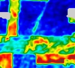


7 Continental (10km) Regional (5km) Watershed (1km) Catchment (60m) Field scale (30m) 30 SURFACE TEMPERATURE EVAPOTRANSPIRATION 500 Latent Heat (Wm -2 ) CORN 300 SOY July :30AM CST DisALEXI (USU aircraft) DisALEXI (Landsat) Temperature (C) ALEXI (GOES Imager) ALEXI (GOES Sounder) DisALEXI (MODIS)

 GOES - East")
8 GOES Coverage Copyright 2008 EUMETSAT Copyright 2008 EUMETSAT GOES West (Pacific) GOES - East


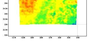
9 Low EVAPOTRANSPIRATION (Wm -2 ) High (Anderson et al, 2007) SEP AUG JUL JUN MAY APR

10 ALEXI validation sites SMEX04 Fort Peck Black Hills Bushland Sevilleta Audubon SMEX02/05 Bondville SGP97 Goodwin Creek Walker Branch Everglades BARC Gainesville
11 Clear-sky fluxes using Landsat thermal (60m) 800 Modeled flux (Wm -2 ) RN ET H G rangeland pasture corn soybean RMSD: 33 Wm -2 (10%) Tower flux (Wm -2 ) (Anderson et al, 2007)
12 APPLICATIONS drought & stress monitoring AET ESI = 1 PET Evaporative Stress Index
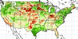
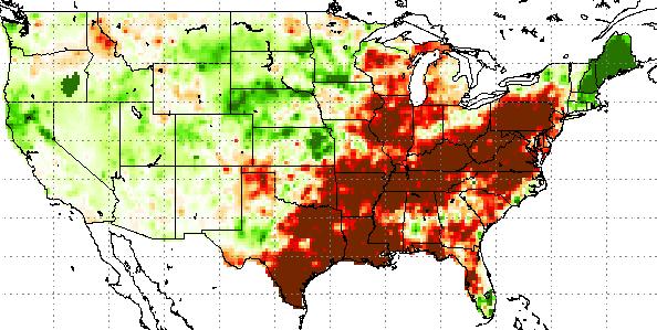
13 Climatological Study: Cumulative areal percentage Palmer Drought Index - NCDC Extreme wet Extreme dry Date 2002: extreme-severe drought conditions covering 40% of the US in July 2003: some improvement (10-25% extreme-severe drought coverage) 2004: extreme drought coverage falls < 5% due to increased late rainfall 2005: wetter than average in western US, drought in east


14 SEP AUG JUL JUN MAY APR MONTHLY ESI ANOMALIES DRY WET


15 ΔESI 2002 ΔZ Evaporative Stress Index Dry 2002 Wet SEP AUG JUL JUN MAY APR 2002


16 ΔESI 2003 ΔZ Dry Evaporative Stress Index 2003 Wet SEP AUG JUL JUN MAY APR 2003


17 ΔESI 2004 ΔZ Dry Evaporative Stress Index 2004 Wet SEP AUG JUL JUN MAY APR 2004

18 ΔESI 2005 ΔZ Dry Evaporative Stress Index 2005 Wet SEP AUG JUL JUN MAY APR 2005


19 ALEXI Precipitation Dry ESI anomaly Wet Precipitation anomaly (mm)


20 Multi-scale Drought Monitoring GOES Evaporative Stress Index JUNE 2002 Palmer Z Index Anomaly


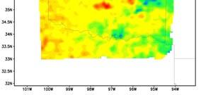
21 Landsat 2/13/02

 MODIS (1km) L7")
")
22 Multi-scale Ecosystem Health Monitoring FLORIDA EVERGLADES GOES (10km) MODIS (1km) L7 (60m) (hourly) (daily) (monthly) Evapotranspiration (Wm -2 )

 L7 (60m) TIR descoped")
 Evaporative stress")
23 Multi-scale Ecosystem Health Monitoring FLORIDA EVERGLADES GOES (10km) MODIS (1km) L7 (60m) TIR descoped from LDCM (hourly) (daily) (monthly) Evaporative stress (high) (low)
24 Impending data gap in high-resolution TIR Pixel Scale Spatial Resolution Temporal Resolution Current Sources Future Sources Coarse 5-20 km 15 min AIRS GOES MSG CrIS GOES MSG Moderate 1 km 2-4 times daily MODIS AVHRR ATSR VIIRS AVHRR ATSR Fine m Once every 8-16 days ASTER Landsat HyspIRI-TIR? Table from S. Hook
25 APPLICATIONS soil moisture mapping


")


26 MESONET ALEXI MESONET ALEXI June 19, 2002 August 1, 2003 May 12, 2003 May 7, May 29, 2003 June 2, AWF (% 0-100cm) 0 July 5, 2003 August 3, 2004 (Hain et al., 2008)
27 Volumetric Soil Moisture Retrievals r 2 = 0.53 RMSD = 0.06 Bias = ALEXI ALEXI VSM ALEXI AWF LAI < > Observed AWF Observed VSM (0-100 cm)


28 Improving weather forecast accuracy 2-m temperature bias 2-m dewpoint bias ALEXI SM Control 1800 UTC 1 Aug UTC 2 Aug UTC 1 Aug UTC 2 Aug 2004
29 Assimilation into hydrologic models No Assimilation Assimilation Assimilating thermal-based ET/PET Assimilating surface temperature directly Crow et al., RSE 2007

30 CONCLUSIONS THERMAL REMOTE SENSING DATA HAVE GREAT UTILITY: ET mapping drought monitoring soil moisture mapping NEED TO MAINTAIN MULTI-SCALE THERMAL DATA SOURCES
 METEOSAT COVERAGE Copyright")

31 ALEXI_EUROPE and _AFRICA (coming soon) METEOSAT COVERAGE Copyright 2008 EUMETSAT Copyright 2008 EUMETSAT 0 o Operational Indian Ocean


 1 0.")
32 METEOSAT Application LEBRIJA, SPAIN Evapotranspiration ESI (low) (high)
33 1.0 Soil evaporation Transpiration Actual/potential ET ET Actual/potential ET ET Soil Available water Available fraction w ater fraction (soil surface) Canopy Available water Available fraction w ater (root zone) 0-5cm 1-2m
Multi-scale Remote Assessment of Land-surface Hydrologic Response to Stress
 Multi-scale Remote Assessment of Land-surface Hydrologic Response to Stress M.C. Anderson J.M. Norman U Wisconsin-Madison W.P. Kustas USDA-ARS, HRSL T.P. Meyers NOAA-ATDD J.M. Jacobs U New Hampshire NASA
John R. Mecikalski #1, Martha C. Anderson*, Ryan D. Torn #, John M. Norman*, George R. Diak #
 P4.22 THE ATMOSPHERE-LAND EXCHANGE INVERSE (ALEXI) MODEL: REGIONAL- SCALE FLUX VALIDATIONS, CLIMATOLOGIES AND AVAILABLE SOIL WATER DERIVED FROM REMOTE SENSING INPUTS John R. Mecikalski #1, Martha C. Anderson*,
Evaporative Fraction and Bulk Transfer Coefficients Estimate through Radiometric Surface Temperature Assimilation
 Evaporative Fraction and Bulk Transfer Coefficients Estimate through Radiometric Surface Temperature Assimilation Francesca Sini, Giorgio Boni CIMA Centro di ricerca Interuniversitario in Monitoraggio
The Two Source Energy Balance model using satellite, airborne and proximal remote sensing
 The using satellite, airborne and proximal remote sensing 7 years in a relationship Héctor Nieto Hector.nieto@irta.cat Resistance Energy Balance Models (REBM) E R e n H G Physics based on an analogy to
Chiang Rai Province CC Threat overview AAS1109 Mekong ARCC
 Chiang Rai Province CC Threat overview AAS1109 Mekong ARCC This threat overview relies on projections of future climate change in the Mekong Basin for the period 2045-2069 compared to a baseline of 1980-2005.
6.3 ESTIMATING THE LAND-SURFACE RADIANT, TURBULENT AND CONDUCTIVE ENERGY BUDGETS USING SATELLITE SYSTEMS AND COMPLEMENTARY SYNOPTIC DATA
 6.3 ESTIMATING THE LAND-SURFACE RADIANT, TURBULENT AND CONDUCTIVE ENERGY BUDGETS USING SATELLITE SYSTEMS AND COMPLEMENTARY SYNOPTIC DATA George R. Diak *1,John R. Mecikalski 1, Martha C. Anderson 1, John
JOURNAL OF GEOPHYSICAL RESEARCH, VOL. 112, D10117, doi: /2006jd007506, 2007
 Click Here for Full Article JOURNAL OF GEOPHYSICAL RESEARCH, VOL. 112,, doi:10.1029/2006jd007506, 2007 A climatological study of evapotranspiration and moisture stress across the continental United States
2009 Progress Report To The National Aeronautics and Space Administration NASA Energy and Water Cycle Study (NEWS) Program
 Program") 2009 Progress Report To The National Aeronautics and Space Administration NASA Energy and Water Cycle Study (NEWS) Program Proposal Title: Grant Number: PI: The Challenges of Utilizing Satellite Precipitation
2009 Progress Report To The National Aeronautics and Space Administration NASA Energy and Water Cycle Study (NEWS) Program Proposal Title: Grant Number: PI: The Challenges of Utilizing Satellite Precipitation
Views of the 2016 Northern Plains Flash Drought: Farmer Perspectives and Remote Sensing Data
 Views of the 2016 Northern Plains Flash Drought: Farmer Perspectives and Remote Sensing Data PRESENTATION BY TONY MUCIA RESEARCH CONDUCTED BY JASON OTKIN, TONYA HAIGHT, AND TONY MUCIA Project Overview
Evapotranspiration monitoring with Meteosat Second Generation satellites: method, products and utility in drought detection.
 Evapotranspiration monitoring with Meteosat Second Generation satellites: method, products and utility in drought detection. Nicolas Ghilain Royal Meteorological Institute Belgium EUMeTrain Event week
METRIC tm. Mapping Evapotranspiration at high Resolution with Internalized Calibration. Shifa Dinesh
 METRIC tm Mapping Evapotranspiration at high Resolution with Internalized Calibration Shifa Dinesh Outline Introduction Background of METRIC tm Surface Energy Balance Image Processing Estimation of Energy
Thermal-Based Evaporative Stress Index for Monitoring Surface Moisture Depletion
 University of Nebraska - Lincoln DigitalCommons@University of Nebraska - Lincoln Drought Mitigation Center Faculty Publications Drought -- National Drought Mitigation Center 2012 Thermal-Based Evaporative
Predicting Growing Season Grassland Production in the Spring using Sea Surface Temperatures, NDVI, and Grass-Cast
 Predicting Growing Season Grassland Production in the Spring using Sea Surface Temperatures, NDVI, and Grass-Cast William Parton 1, Melannie Hartman 1, Maosi Chen 1, Stephen Del Grosso 1,2, Justin Derner
NIDIS Remote Sensing Workshop: Showcase of Products & Technologies
 Feature Article From Intermountain West Climate Summary, April 2008 NIDIS Remote Sensing Workshop: Showcase of Products & Technologies By Christina Alvord of WWA Three knowledge assessment workshops are
Evaluation of Drought Indices Based on Thermal Remote Sensing of Evapotranspiration over the Continental United States
 University of Nebraska - Lincoln DigitalCommons@University of Nebraska - Lincoln Drought Mitigation Center Faculty Publications Drought -- National Drought Mitigation Center 4-15-2011 Evaluation of Drought
Satellite Activities and Products for Hydrological Applications: NOAA & CEOS
 GEO UNESCO Workshop: AfWCCI Demo Project Session Satellite Activities and Products for Hydrological Applications: NOAA & CEOS Jacob Sutherlun National Oceanic and Atmospheric Administration Vice-Chair
Flux Tower Data Quality Analysis in the North American Monsoon Region
 Flux Tower Data Quality Analysis in the North American Monsoon Region 1. Motivation The area of focus in this study is mainly Arizona, due to data richness and availability. Monsoon rains in Arizona usually
EUMETSAT LSA-SAF EVAPOTRANSPIRATION PRODUCTS STATUS AND PERSPECTIVES
 EUMETSAT LSA-SAF EVAPOTRANSPIRATION PRODUCTS STATUS AND PERSPECTIVES Arboleda, N. Ghilain, F. Gellens-Meulenberghs Royal Meteorological Institute, Avenue Circulaire, 3, B-1180 Bruxelles, BELGIUM Corresponding
Characterizing the multi scale spatial structure of remotely sensed evapotranspiration with information theory
 doi:10.5194/bg-8-2269-2011 Author(s) 2011. CC Attribution 3.0 License. Biogeosciences Characterizing the multi scale spatial structure of remotely sensed evapotranspiration with information theory N. A.
AQRP Project Use of Satellite Data to Improve Specifications of Land Surface Parameters
 AQRP Project 14-022 Use of Satellite Data to Improve Specifications of Land Surface Parameters By Richard T. McNider, Kevin Doty and Yu Ling Wu, ESSC University of Alabama Huntsville And Pius Lee NOAA
Assimilation of satellite derived soil moisture for weather forecasting
 Assimilation of satellite derived soil moisture for weather forecasting www.cawcr.gov.au Imtiaz Dharssi and Peter Steinle February 2011 SMOS/SMAP workshop, Monash University Summary In preparation of the
Comparison of NASA AIRS and MODIS Land Surface Temperature and Infrared Emissivity Measurements from the EOS AQUA platform
 Comparison of NASA AIRS and MODIS Land Surface Temperature and Infrared Emissivity Measurements from the EOS AQUA platform Robert Knuteson, Steve Ackerman, Hank Revercomb, Dave Tobin University of Wisconsin-Madison
Comparison of Wind Speed, Soil Moisture, and Cloud Cover to Relative Humidity to Verify Dew Formation
 Meteorology Senior Theses Undergraduate Theses and Capstone Projects 12-1-2017 Comparison of Wind Speed, Soil Moisture, and Cloud Cover to Relative Humidity to Verify Dew Formation Kelly M. Haberichter
Analyzing and Visualizing Precipitation and Soil Moisture in ArcGIS
 Analyzing and Visualizing Precipitation and Soil Moisture in ArcGIS Wenli Yang, Pham Long, Peisheng Zhao, Steve Kempler, and Jennifer Wei * NASA Goddard Earth Science Data and Information Services Center
Towards a Better Monitoring of Soil Moisture Using a Combination of Estimates from Passive of Microwave and Infrared Observations
 City University of New York (CUNY) CUNY Academic Works Master's Theses City College of New York 2011 Towards a Better Monitoring of Soil Moisture Using a Combination of Estimates from Passive of Microwave
Estimation of Wavelet Based Spatially Enhanced Evapotranspiration Using Energy Balance Approach
 Estimation of Wavelet Based Spatially Enhanced Evapotranspiration Using Energy Balance Approach Dr.Gowri 1 Dr.Thirumalaivasan 2 1 Associate Professor, Jerusalem College of Engineering, Department of Civil
ASSESSMENT OF DIFFERENT WATER STRESS INDICATORS BASED ON EUMETSAT LSA SAF PRODUCTS FOR DROUGHT MONITORING IN EUROPE
 ASSESSMENT OF DIFFERENT WATER STRESS INDICATORS BASED ON EUMETSAT LSA SAF PRODUCTS FOR DROUGHT MONITORING IN EUROPE G. Sepulcre Canto, A. Singleton, J. Vogt European Commission, DG Joint Research Centre,
Flash Droughts: Their Characteristics and A Proposed Definition
 Flash Droughts: Their Characteristics and A Proposed Definition Jason Otkin University of Wisconsin-Madison, Cooperative Institute for Meteorological Satellite Studies Jeff Basara and Jordan Christian
Utilization of Forecast Models in High Temporal GOES Sounding Retrievals
 Utilization of Forecast Models in High Temporal GOES Sounding Retrievals Zhenglong Li, Jun Li, W. Paul Menzel, Steve Ackerman CIMSS/UW The CoRP Symposium Aug 12-13, 2008 Corvallis, OR Introduction: GOES
Hurricane Floyd Symposium. Satellite Precipitation as a Tool to Reanalyze Hurricane Floyd and Forecast Probabilities of Extreme Rainfall
 Sept. 18, 2009 Hurricane Floyd Symposium Scott Curtis, East Carolina Universtiy Satellite Precipitation as a Tool to Reanalyze Hurricane Floyd and Forecast Probabilities of Extreme Rainfall What was the
USE OF SATELLITE REMOTE SENSING IN HYDROLOGICAL PREDICTIONS IN UNGAGED BASINS
 USE OF SATELLITE REMOTE SENSING IN HYDROLOGICAL PREDICTIONS IN UNGAGED BASINS Venkat Lakshmi, PhD, P.E. Department of Geological Sciences, University of South Carolina, Columbia SC 29208 (803)-777-3552;
A Facility for Producing Consistent Remotely Sensed Biophysical Data Products of Australia
 TERRESTRIAL ECOSYSTEM RESEARCH NETWORK - AusCover - A Facility for Producing Consistent Remotely Sensed Biophysical Data Products of Australia June, 2011 Mervyn Lynch Professor of Remote Sensing Curtin
Evaluation of remotely sensed and modelled soil moisture products using global ground-based in situ observations
 Evaluation of remotely sensed and modelled soil moisture products using global ground-based in situ observations C. Albergel (1), P. de Rosnay (1), G. Balsamo (1),J. Muñoz-Sabater(1 ), C. Gruhier (2),
Quenching the Valley s thirst: The connection between Sierra Nevada snowpack & regional water supply
 Quenching the Valley s thirst: The connection between Sierra Nevada snowpack & regional water supply Roger Bales, UC Merced Snow conditions Snow & climate change Research directions Sierra Nevada snow
Climate Change and Arizona s Rangelands: Management Challenges and Opportunities
 Climate Change and Arizona s Rangelands: Management Challenges and Opportunities Mike Crimmins Climate Science Extension Specialist Dept. of Soil, Water, & Env. Science & Arizona Cooperative Extension
Soil Moisture Prediction and Assimilation
 Soil Moisture Prediction and Assimilation Analysis and Prediction in Agricultural Landscapes Saskatoon, June 19-20, 2007 STEPHANE BELAIR Meteorological Research Division Prediction and Assimilation Atmospheric
NOAA Soil Moisture Operational Product System (SMOPS): Version 2
: Version 2") CICS-MD Science Meeting (November 12-13, 2014) NOAA Soil Moisture Operational Product System (SMOPS): Version 2 Jicheng Liu 1, 2, Xiwu Zhan 2, Limin Zhao 3, Christopher R. Hain 1, 2, Li Fang 1,2, Jifu
CICS-MD Science Meeting (November 12-13, 2014) NOAA Soil Moisture Operational Product System (SMOPS): Version 2 Jicheng Liu 1, 2, Xiwu Zhan 2, Limin Zhao 3, Christopher R. Hain 1, 2, Li Fang 1,2, Jifu
Data assimilation of IASI radiances over land.
 Data assimilation of IASI radiances over land. PhD supervised by Nadia Fourrié, Florence Rabier and Vincent Guidard. 18th International TOVS Study Conference 21-27 March 2012, Toulouse Contents 1. IASI
Presentation Overview. Southwestern Climate: Past, present and future. Global Energy Balance. What is climate?
 Southwestern Climate: Past, present and future Mike Crimmins Climate Science Extension Specialist Dept. of Soil, Water, & Env. Science & Arizona Cooperative Extension The University of Arizona Presentation
Surface Anomalies Prior to Earthquakes
 Surface Anomalies Prior to Earthquakes Habibeh Valizadeh, Shattri B. Mansor Husaini Omar and Farid Azad Department of Civil Engineering Universiti Putra Malaysia Serdang, Selangor Malaysia shattri@eng.upm.edu.my
Land Surface Temperature in the EUMETSAT LSA SAF: Current Service and Perspectives. Isabel Trigo
 Land Surface Temperature in the EUMETSAT LSA SAF: Current Service and Perspectives Isabel Trigo Outline EUMETSAT Land-SAF: Land Surface Temperature Geostationary Service SEVIRI Polar-Orbiter AVHRR/Metop
Feature-tracked 3D Winds from Satellite Sounders: Derivation and Impact in Global Models
 Feature-tracked 3D Winds from Satellite Sounders: Derivation and Impact in Global Models David Santek, Anne-Sophie Daloz 1, Samantha Tushaus 1, Marek Rogal 1, Will McCarty 2 1 Space Science and Engineering
Evapotranspiration. Andy Black. CCRN Processes Workshop, Hamilton, ON, Sept Importance of evapotranspiration (E)
") Evapotranspiration Andy Black CCRN Processes Workshop, Hamilton, ON, 12-13 Sept 213 Importance of evapotranspiration (E) This process is important in CCRN goals because 1. Major component of both terrestrial
Evapotranspiration Andy Black CCRN Processes Workshop, Hamilton, ON, 12-13 Sept 213 Importance of evapotranspiration (E) This process is important in CCRN goals because 1. Major component of both terrestrial
Estimating Evaporation : Principles, Assumptions and Myths. Raoul J. Granger, NWRI
 Estimating Evaporation : Principles, Assumptions and Myths Raoul J. Granger, NWRI Evaporation So what is it anyways? Evaporation is the phenomenon by which a substance is converted from the liquid or solid
Evaluating Parametrizations using CEOP
 Evaluating Parametrizations using CEOP Paul Earnshaw and Sean Milton Met Office, UK Crown copyright 2005 Page 1 Overview Production and use of CEOP data Results SGP Seasonal & Diurnal cycles Other extratopical
ECMWF. ECMWF Land Surface Analysis: Current status and developments. P. de Rosnay M. Drusch, K. Scipal, D. Vasiljevic G. Balsamo, J.
 Land Surface Analysis: Current status and developments P. de Rosnay M. Drusch, K. Scipal, D. Vasiljevic G. Balsamo, J. Muñoz Sabater 2 nd Workshop on Remote Sensing and Modeling of Surface Properties,
Geostatistical Analysis of Rainfall Temperature and Evaporation Data of Owerri for Ten Years
 Atmospheric and Climate Sciences, 2012, 2, 196-205 http://dx.doi.org/10.4236/acs.2012.22020 Published Online April 2012 (http://www.scirp.org/journal/acs) Geostatistical Analysis of Rainfall Temperature
Land Data Assimilation at NCEP NLDAS Project Overview, ECMWF HEPEX 2004
 Dag.Lohmann@noaa.gov, Land Data Assimilation at NCEP NLDAS Project Overview, ECMWF HEPEX 2004 Land Data Assimilation at NCEP: Strategic Lessons Learned from the North American Land Data Assimilation System
Diagnosing the Climatology and Interannual Variability of North American Summer Climate with the Regional Atmospheric Modeling System (RAMS)
") Diagnosing the Climatology and Interannual Variability of North American Summer Climate with the Regional Atmospheric Modeling System (RAMS) Christopher L. Castro and Roger A. Pielke, Sr. Department of
Diagnosing the Climatology and Interannual Variability of North American Summer Climate with the Regional Atmospheric Modeling System (RAMS) Christopher L. Castro and Roger A. Pielke, Sr. Department of
Improved assimilation of IASI land surface temperature data over continents in the convective scale AROME France model
 Improved assimilation of IASI land surface temperature data over continents in the convective scale AROME France model Niama Boukachaba, Vincent Guidard, Nadia Fourrié CNRM-GAME, Météo-France and CNRS,
Indian National (Weather) SATellites for Agrometeorological Applications
 SATellites for Agrometeorological Applications") Indian National (Weather) SATellites for Agrometeorological Applications Bimal K. Bhattacharya Agriculture-Terrestrial Biosphere- Hydrology Group Space Applications Centre (ISRO) Ahmedabad 380015, India
Indian National (Weather) SATellites for Agrometeorological Applications Bimal K. Bhattacharya Agriculture-Terrestrial Biosphere- Hydrology Group Space Applications Centre (ISRO) Ahmedabad 380015, India
METEOSAT SECOND GENERATION DATA FOR ASSESSMENT OF SURFACE MOISTURE STATUS
 METEOSAT SECOND GENERATION DATA FOR ASSESSMENT OF SURFACE MOISTURE STATUS Simon Stisen (1), Inge Sandholt (1), Rasmus Fensholt (1) (1) Institute of Geography, University of Copenhagen, Oestervoldgade 10,
Drought Monitoring with Hydrological Modelling
 st Joint EARS/JRC International Drought Workshop, Ljubljana,.-5. September 009 Drought Monitoring with Hydrological Modelling Stefan Niemeyer IES - Institute for Environment and Sustainability Ispra -
Enhancing Weather Forecasts via Assimilating SMAP Soil Moisture and NRT GVF
 CICS Science Meeting, ESSIC, UMD, 2016 Enhancing Weather Forecasts via Assimilating SMAP Soil Moisture and NRT GVF Li Fang 1,2, Christopher Hain 1,2, Xiwu Zhan 2, Min Huang 1,2 Jifu Yin 1,2, Weizhong Zheng
MONITORING OF WATER USE, DROUGHT AND YIELD IMPACTS OF WINTER WHEAT USING IMAGINERY FROM SATELLITES
 MONITORING OF WATER USE, DROUGHT AND YIELD IMPACTS OF WINTER WHEAT USING IMAGINERY FROM SATELLITES JURECKA FRANTISEK 1,2, ANDERSON MARTHA 3, HLAVINKA PETR 1,2, SEMERADOVA DANIELA 1,2, TRNKA MIROSLAV 1,2,
Land atmosphere atmosphere coupling: How satellite LST data contribute to drought assessment and yield prediction
 Land atmosphere atmosphere coupling: How satellite LST data contribute to drought assessment and yield prediction Julia Stoyanova & Christo Georgiev National Institute of Meteorology and Hydrology (NIMH),
Changing Hydrology under a Changing Climate for a Coastal Plain Watershed
 Changing Hydrology under a Changing Climate for a Coastal Plain Watershed David Bosch USDA-ARS, Tifton, GA Jeff Arnold ARS Temple, TX and Peter Allen Baylor University, TX SEWRU Objectives 1. Project changes
Joint International Surface Working Group and Satellite Applications Facility on Land Surface Analysis Workshop, IPMA, Lisboa, June 2018
 Joint International Surface Working Group and Satellite Applications Facility on Land Surface Analysis Workshop, IPMA, Lisboa, 26-28 June 2018 Introduction Soil moisture Evapotranspiration Future plan
Remote sensing estimates of actual evapotranspiration in an irrigation district
 Engineers Australia 29th Hydrology and Water Resources Symposium 21 23 February 2005, Canberra Remote sensing estimates of actual evapotranspiration in an irrigation district Cressida L. Department of
Land Management and Natural Hazards Unit --- DESERT Action 1. Land Management and Natural Hazards Unit Institute for Environment and Sustainability
 Land Management and Natural Hazards Unit --- DESERT Action 1 Monitoring Drought with Meteorological and Remote Sensing Data A case study on the Horn of Africa Paulo Barbosa and Gustavo Naumann Land Management
Eric. W. Harmsen 1, John Mecikalski 2, Vanessa Acaron 3 and Jayson Maldonado 3
 Estimating Ground-Level Solar Radiation and Evapotranspiration In Puerto Rico Using Satellite Remote Sensing Eric. W. Harmsen 1, John Mecikalski 2, Vanessa Acaron 3 and Jayson Maldonado 3 1 Department
Eric. W. Harmsen 1, John Mecikalski 2, Pedro Tosado Cruz 1 Ariel Mercado Vargas 1
 Estimating Evapotranspiration using Satellite Remote Sensing in Puerto Rico, Haiti and the Dominican Republic Eric. W. Harmsen 1, John Mecikalski 2, Pedro Tosado Cruz 1 Ariel Mercado Vargas 1 1. University
Atmospheric Sciences 321. Science of Climate. Lecture 14: Surface Energy Balance Chapter 4
 Atmospheric Sciences 321 Science of Climate Lecture 14: Surface Energy Balance Chapter 4 Community Business Check the assignments HW #4 due Today, HW#5 is posted Quiz Today on Chapter 3, too. Mid Term
Accuracy Issues Associated with Satellite Remote Sensing Soil Moisture Data and Their Assimilation
 Proceedings of the 8th International Symposium on Spatial Accuracy Assessment in Natural Resources and Environmental Sciences Shanghai, P. R. China, June 25-27, 2008, pp. 213-220 Accuracy Issues Associated
Evaluation of a MODIS Triangle-based Algorithm for Improving ET Estimates in the Northern Sierra Nevada Mountain Range
 Evaluation of a MODIS Triangle-based Algorithm for Improving ET Estimates in the Northern Sierra Nevada Mountain Range Kyle R. Knipper 1, Alicia M. Kinoshita 2, and Terri S. Hogue 1 January 5 th, 2015
Hua Zhang, Steven M. Gorelick, Nicolas Avisse, Amaury Tilmant, Deepthi Rajsekhar, and Jim Yoon
 Remote Sens. 216,, 735; doi:1.339/rs9735 S1 of S5 Supplementary Materials: A New Temperature- Vegetation Triangle Algorithm with Variable Edges (VE) for Satellite-Based Actual Evapotranspiration Estimation
Measuring the surface temperatures of the earth from space. Darren Ghent, University of Leicester 13/09/2018
 Measuring the surface temperatures of the earth from space Darren Ghent, University of Leicester 13/09/2018 Contents Background Challenges of measuring Land Surface Temperature Applications Current capability
Global Satellite Products & Services for Agricultural and Vegetation Health
 Global Satellite Products & Services for Agricultural and Vegetation Health Presented at the WMO Expert Meeting on National Early Warning System for Agricultural Weather Management George Mason University
Use of satellite information in research and operational activities at NIMH of Bulgaria
 Use of satellite information in research and operational activities at NIMH of Bulgaria Rilka Valcheva NIMH, Bulgaria WMO/EUMETSAT Satellite Products Training Course 24-28 April 2017, Budapest, Hungary
Interpretation of Polar-orbiting Satellite Observations. Atmospheric Instrumentation
 Interpretation of Polar-orbiting Satellite Observations Outline Polar-Orbiting Observations: Review of Polar-Orbiting Satellite Systems Overview of Currently Active Satellites / Sensors Overview of Sensor
Learning Objectives. Thermal Remote Sensing. Thermal = Emitted Infrared
 November 2014 lava flow on Kilauea (USGS Volcano Observatory) (http://hvo.wr.usgs.gov) Landsat-based thermal change of Nisyros Island (volcanic) Thermal Remote Sensing Distinguishing materials on the ground
Land Data Assimilation for operational weather forecasting
 Land Data Assimilation for operational weather forecasting Brett Candy Richard Renshaw, JuHyoung Lee & Imtiaz Dharssi * *Centre Australian Weather and Climate Research Contents An overview of the Current
Results of the ESA-DUE UHI project
 13/12/2011 Results of the ESA-DUE UHI project Bino Maiheu (bino.maiheu@vito.be), on behalf of the UHI project Outline» Urban heat island problem» The ESA-DUE urban heat island project» UHI air temperature
SAIL thermique, a model to simulate land surface emissivity (LSE) spectra
 spectra") SAIL thermique, a model to simulate land surface emissivity (LSE) spectra Albert Olioso, INRA, UMR EMMAH (INRA UAPV), Avignon, France Frédéric Jacob, Audrey Lesaignoux IRD, UMR LISAH, Montpellier, France
SAIL thermique, a model to simulate land surface emissivity (LSE) spectra Albert Olioso, INRA, UMR EMMAH (INRA UAPV), Avignon, France Frédéric Jacob, Audrey Lesaignoux IRD, UMR LISAH, Montpellier, France
USGS Water Census Guidelines and Specifications for ET Remote Sensing
 USGS Water Census Guidelines and Specifications for ET Remote Sensing U.S. Department of the Interior U.S. Geological Survey Guidelines and specifications Many prior and ongoing crop ET remote sensing
10. FIELD APPLICATION: 1D SOIL MOISTURE PROFILE ESTIMATION
 Chapter 1 Field Application: 1D Soil Moisture Profile Estimation Page 1-1 CHAPTER TEN 1. FIELD APPLICATION: 1D SOIL MOISTURE PROFILE ESTIMATION The computationally efficient soil moisture model ABDOMEN,
Assimilation of ASCAT soil wetness
 EWGLAM, October 2010 Assimilation of ASCAT soil wetness Bruce Macpherson, on behalf of Imtiaz Dharssi, Keir Bovis and Clive Jones Contents This presentation covers the following areas ASCAT soil wetness
«Action Thématique Incitative sur Programme» CNRS/INSU
 Development and validation of a regional model of desert dust for the study of seasonal and interannual variations over Sahara and Sahel coupling with satellite observations «Action Thématique Incitative
AIRS and IASI Precipitable Water Vapor (PWV) Absolute Accuracy at Tropical, Mid-Latitude, and Arctic Ground-Truth Sites
 Absolute Accuracy at Tropical, Mid-Latitude, and Arctic Ground-Truth Sites") AIRS and IASI Precipitable Water Vapor (PWV) Absolute Accuracy at Tropical, Mid-Latitude, and Arctic Ground-Truth Sites Robert Knuteson, Sarah Bedka, Jacola Roman, Dave Tobin, Dave Turner, Hank Revercomb
AIRS and IASI Precipitable Water Vapor (PWV) Absolute Accuracy at Tropical, Mid-Latitude, and Arctic Ground-Truth Sites Robert Knuteson, Sarah Bedka, Jacola Roman, Dave Tobin, Dave Turner, Hank Revercomb
LAND SURFACE ALBEDO AND DOWNWELLING SHORTWAVE RADIATION FROM MSG GEOSTATIONARY SATELLITE (METHOD FOR RETRIEVAL, VALIDATION, AND APPLICATION)
") LAND SURFACE ALBEDO AND DOWNWELLING SHORTWAVE RADIATION FROM MSG GEOSTATIONARY SATELLITE (METHOD FOR RETRIEVAL, VALIDATION, AND APPLICATION) Dominique Carrer, Jean-Louis Roujean, Olivier Hautecoeur, Jean-Christophe
LAND SURFACE ALBEDO AND DOWNWELLING SHORTWAVE RADIATION FROM MSG GEOSTATIONARY SATELLITE (METHOD FOR RETRIEVAL, VALIDATION, AND APPLICATION) Dominique Carrer, Jean-Louis Roujean, Olivier Hautecoeur, Jean-Christophe
Land Surface Processes and Their Impact in Weather Forecasting
 Land Surface Processes and Their Impact in Weather Forecasting Andrea Hahmann NCAR/RAL with thanks to P. Dirmeyer (COLA) and R. Koster (NASA/GSFC) Forecasters Conference Summer 2005 Andrea Hahmann ATEC
Many of remote sensing techniques are generic in nature and may be applied to a variety of vegetated landscapes, including
 Remote Sensing of Vegetation Many of remote sensing techniques are generic in nature and may be applied to a variety of vegetated landscapes, including 1. Agriculture 2. Forest 3. Rangeland 4. Wetland,
The Texas drought. Kingtse Mo Climate Prediction Center NWS/NCEP/NOAA
 The 2011-2012 Texas drought Kingtse Mo Climate Prediction Center NWS/NCEP/NOAA 1 outline Evolution of the 2011-2012 Texas drought Climatology and historical perspective The 2011 drought Onset Feedback
Regional Drought and Crop Yield Information System to enhance drought monitoring and forecasting in Lower Mekong region
 Regional Drought and Crop Yield Information System to enhance drought monitoring and forecasting in Lower Mekong region Asian Disaster Preparedness Center/SERVIR-Mekong 2 Anticipated Results Improved capacity
Evaluation strategies of coarse resolution SM products for monitoring deficit/excess conditions in the Pampas Plains, Argentina
 Evaluation strategies of coarse resolution SM products for monitoring deficit/excess conditions in the Pampas Plains, Argentina Francisco Grings, Cintia Bruscantini, Federico Carballo, Ezequiel Smucler,
Remote Sensing Applications for Land/Atmosphere: Earth Radiation Balance
 Remote Sensing Applications for Land/Atmosphere: Earth Radiation Balance - Introduction - Deriving surface energy balance fluxes from net radiation measurements - Estimation of surface net radiation from
Climate Roles of Land Surface
 Lecture 5: Land Surface and Cryosphere (Outline) Climate Roles Surface Energy Balance Surface Water Balance Sea Ice Land Ice (from Our Changing Planet) Surface Albedo Climate Roles of Land Surface greenhouse
Use of satellite soil moisture information for NowcastingShort Range NWP forecasts
 Use of satellite soil moisture information for NowcastingShort Range NWP forecasts Francesca Marcucci1, Valerio Cardinali/Paride Ferrante1,2, Lucio Torrisi1 1 COMET, Italian AirForce Operational Center
Current status of lake modelling and initialisation at ECMWF
 Current status of lake modelling and initialisation at ECMWF G Balsamo, A Manrique Suñen, E Dutra, D. Mironov, P. Miranda, V Stepanenko, P Viterbo, A Nordbo, R Salgado, I Mammarella, A Beljaars, H Hersbach
Land data assimilation in the NASA GEOS-5 system: Status and challenges
 Blueprints for Next-Generation Data Assimilation Systems Boulder, CO, USA 8-10 March 2016 Land data assimilation in the NASA GEOS-5 system: Status and challenges Rolf Reichle Clara Draper, Ricardo Todling,
Technical Note: Hydrology of the Lake Chilwa wetland, Malawi
 Technical Note: Hydrology of the Lake Chilwa wetland, Malawi Matthew McCartney June 27 Description Lake Chilwa is located in the Southern region of Malawi on the country s eastern boarder with Mozambique
Remote Sensing Applications in Water Resources. D. Nagesh Kumar* and T.V. Reshmidevi
 Journal of the Indian Institute of Science A Multidisciplinary Reviews Journal ISSN: 0970-4140 Coden-JIISAD Indian Institute of Science Remote Sensing Applications in Water Resources D. Nagesh Kumar* and
Impact of assimilating the VIIRS-based CrIS cloudcleared radiances on hurricane forecasts
 Impact of assimilating the VIIRS-based CrIS cloudcleared radiances on hurricane forecasts Jun Li @, Pei Wang @, Jinlong Li @, Zhenglong Li @, Jung-Rim Lee &, Agnes Lim @, Timothy J. Schmit #, and Mitch
A high spectral resolution global land surface infrared emissivity database
 A high spectral resolution global land surface infrared emissivity database Eva E. Borbas, Robert O. Knuteson, Suzanne W. Seemann, Elisabeth Weisz, Leslie Moy, and Hung-Lung Huang Space Science and Engineering
Remote Sensing Applications for Drought Monitoring
 Remote Sensing Applications for Drought Monitoring Amir AghaKouchak Center for Hydrometeorology and Remote Sensing Department of Civil and Environmental Engineering University of California, Irvine Outline
68 IEEE GEOSCIENCE AND REMOTE SENSING LETTERS, VOL. 12, NO. 1, JANUARY 2015
 68 IEEE GEOSCIENCE AND REMOTE SENSING LETTERS, VOL. 12, NO. 1, JANUARY 2015 Estimating Turbulent Heat Fluxes With a Weak-Constraint Data Assimilation Scheme: A Case Study (HiWATER-MUSOEXE) Tongren Xu,
Estimation of evapotranspiration using satellite TOA radiances Jian Peng
 Estimation of evapotranspiration using satellite TOA radiances Jian Peng Max Planck Institute for Meteorology Hamburg, Germany Satellite top of atmosphere radiances Slide: 2 / 31 Surface temperature/vegetation
Images of the Month. Hot and dry conditions over. April
 I S S U E 2 1 7-5 1 5 M A Y 2 1 7 I N S T I T U T E F O R S O I L, C L I M A T E A N D W A T E R C O N T E N T S : 1. Rainfall 2 2. Standardized Precipitation Index 4 3. Rainfall Deciles 6 4. Water Balance
PRECONVECTIVE SOUNDING ANALYSIS USING IASI AND MSG- SEVIRI
 PRECONVECTIVE SOUNDING ANALYSIS USING IASI AND MSG- SEVIRI Marianne König, Dieter Klaes EUMETSAT, Eumetsat-Allee 1, 64295 Darmstadt, Germany Abstract EUMETSAT operationally generates the Global Instability
Remote sensing derived evapotranspiration: comparisons to observations and models and results over the full MSG disk and selected basins
 4 th LSA-SAF WORKSHOP Toulouse,France, 15 th to 17 th November 2010 Remote sensing derived evapotranspiration: comparisons to observations and models and results over the full MSG disk and selected basins