Remote sensing derived evapotranspiration: comparisons to observations and models and results over the full MSG disk and selected basins
|
|
|
- Madeleine Wilcox
- 5 years ago
- Views:
Transcription
1 4 th LSA-SAF WORKSHOP Toulouse,France, 15 th to 17 th November 2010 Remote sensing derived evapotranspiration: comparisons to observations and models and results over the full MSG disk and selected basins A. Arboleda, N. Ghilain, G. Sepulcre, F. Gellens-Meulenberghs Royal Meteorological Institute Avenue Circulaire, 3 B-1180 Brussels, Belgium
2 Layout Introduction Model description Input data Model output Validation More examples of cumulated output Further developments Concluding remarks
3 Introduction EUMETSAT SATELLITE APPLICATION FACILITIES (SAF S) LSA -SAF Land Surface Analysis OSI -SAF Ocean and Sea Ice GRAS -SAF Meteorology O3M Ozone Monitoring NWP SAF Numerical Weather Prediction CM -SAF Climate Monitoring NWC-SAF - Nowcasting and very Short Range Forecasting LSA -SAF OBJECTIVES Develop techniques to retrieve parameters related to land, land-atmosphere interactions and biospheric applications, by using data from MSG and EPS satellites Albedo (AL) Down welling Surface Short-wave Flux ( DSSF) Down welling Surface Long-wave Flux (DSLF) Evapotranspiration (MET) => DMET Land Surface Temperature (LST) Risk of Fire Mapping (RFM) Snow Cover ( SC) Surface Emissivity ( EM) Vegetation characteristics (FVC, LAI, etc)


![latent heat flux [W evapotranspiration [kg m-2 s-1] Lv ρ](/docs-images/94/118920219/images/4-4.jpg "a [q sat (Tsk,i ) q a (Ta )] rai + rci ( ρa ra i ) [c p")
![Gi = βi Rni (T sk, i T a ) gz a with ] βi = f ( LAI i )](/docs-images/94/118920219/images/4-5.jpg "Pixel value LE = ζ i LE i Evapotranspiration [mm h-1] ET")

4 Methodology MSG SEVIRI pixel Tiles: Bare soil Forest Crops Grassland ET=Evapotranspiration = evaporation + transpiration At tile level (1 α ) S + ε ( L σtsk4,i ) + H i + LEi Gi = 0 LE i = Hi = LE = Lv ET LE: ET: m-2] latent heat flux [W evapotranspiration [kg m-2 s-1] Lv ρ a [q sat (Tsk,i ) q a (Ta )] rai + rci ( ρa ra i ) [c p Gi = βi Rni (T sk, i T a ) gz a with ] βi = f ( LAI i ) Pixel value LE = ζ i LE i Evapotranspiration [mm h-1] ET = 3600 LE/Lv Lv : latent heat of vaporisation Toulouse, 15th- November 2010 LSA-SAF evapotranspiration Arboleda et al.
5 Model input AL -Surface ALbedo- from satellite MSG-II DSSF-Shortwave flux at surface DSLF-Longwave flux at surface LAI -Leaf Area Index- FVC -Fractional Vegetation Cover- LST -Land Surface Temperature- * From database (ECOCLIMAP) T i -Tiles in pixel- FV i -Fraction of tiles- Rs i -Tile minimum stomatal resistance LAI i -Tile Leaf Area Index - FVC i -Tile fractional vegetation cover AL M -Monthly pixel Albedo MODEL FORMULATION MET QF From NWP (ECMWF) Ta -Air temperature- U -Wind speed- Pa -Air pressure - Td -Dew-point temperature- ST -Soil Temperature- SM -Soil Moisture- * -To be included in future versions
6 Model output (Instantaneous) Two images are generated: the first one contains instantaneous ET estimates in mm/h while the second one is the quality flag image, provides information on the quality of estimates pixel by pixel ET [mm/h] for 2010/10/29 at 12:00 UTC Associated quality flag (-)
7 Model output (Instantaneous ET (mm/h) over full MSG disk)
8 Daily eevapotranspiration (DMET) DMET = h 2 METi ( t) dt h 1 The daily evapotranspiration product is obtained as temporal integration of instantaneous values. -MET i is the instantaneous estimate at time i -dt is time interval between 2 images (30 min) -h 1 (00:30),h 2 (24:00), the integration limits

![[mm/day] Toulouse, 15th- November](/docs-images/94/118920219/images/9-3.jpg "2010 LSA-SAF evapotranspiration")
9 Daily ET on full MSG DIISK DMET images from 06/09 to 15/ ET [mm/day] Toulouse, 15th- November 2010 LSA-SAF evapotranspiration Arboleda et al.
10 Validation Stand-alone Approaches Off-line Models inter-comparison:
")


11 Validation (Stand-alone) Stand-alone Validation: By comparing the output of 1-D version of the model to reference values from selected locations/stations in different regions of the world.
12 Validation (Off-line) Compare output generated by the operational (grid) version of the model to in situ observations at pre-defined locations
 Compare")

13 Validation (Off-line) Compare the output of the model to in situ observations
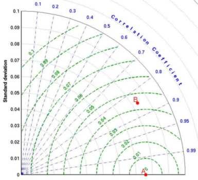


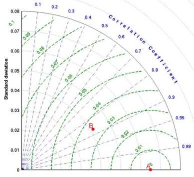

14 Validation (Off-line) Buzenol Cabauw Humain Lobos Roccarespamapni Tojal
15 Summary of off-line validation Station VegetationType * Bias RMS Corr % PRD Amplero G Buzenol G Cabauw G Humain G Monte Bondone G Tojal G Hesse DBF Roccarespampani DBF Loobos ENF Wetzstein ENF Sodankylä ENF Lonzée C Las Majadas EMF Puéchabon EMF Kaamanen B Vielsalm MF Demokeya Ss Target PRD criterion: 25 % for MET > 0.4 mm h mm h -1 for MET < 0.4 mm h -1 (Observed fluxes uncertainty: ~ 20 %) * Grassland (G), Deciduous Broadleaved Forest (DBF), Evergreen Needle Forest (ENF), Crops (C), Mixed Forest (MF), Evergreen Mediterranean Forest (EMF), Ss (Sahelian savannah)
 LSA-SAF - ECMWF LSA-SAF - GLDAS NAfr SAfr LSA-SAF - ECMWF LSA-SAF -")
16 Validation (Models inter-comparison) Compare the output of the ET to output from other models (NWP, GCMs, hydrological models) LSA-SAF - ECMWF LSA-SAF - GLDAS NAfr SAfr LSA-SAF - ECMWF LSA-SAF - GLDAS

17 Validation (Models inter-comparison) Cumulated (12:00 to 18:00 UTC) Evapotranspiration from LSA-SAF ET, ECMWF and GLDAS for the day
 and")

18 Validation (Models inter-comparison) Distribution of DMET (green ) and ECMWF (red) daily values between 01/09/2009 and 31/12/2009 SAfr SAme Euro NAfr
19 Validation (Models inter-comparison) Spatial correlation of daily images from DMET and ECMWF for December 2009 for: Europe (green), North Africa (red), South America (black) and South Africa(blue).
20 Validation (Models inter-comparison) Comparison with ECMWF and GLDA for the period March November 2007 at 1 degree spatial resolution MET / GLDAS MET / ECMWF
21 More examples of cumulated output (Monthly over MSG disk) May 2010 June 2010 (mm/month)
 Sept. 2010 (mm/month) Oct.")
22 More examples of cumulated output (Monthly over MSG disk) Sept (mm/month) Oct. 2010
 West Africa Basin Nile Basin South Atlantic coast Basin Congo")
23 More examples of cumulated output (Monthly over selected hydrological basins in Africa) West Africa Basin Nile Basin South Atlantic coast Basin Congo Basin
 Monthly Evapotranspiration over the Nile basin (May to September 2010)")
24 More examples of cumulated output (Monthly over selected hydrological basins in Africa) Monthly Evapotranspiration over the Nile basin (May to September 2010) (mm/month)
")
25 More examples of cumulated output (Monthly over selected hydrological basins in Africa) Monthly Evapotranspiration over the South Atlantic coast basin ( May to September 2010) (mm/month)

26 More examples of cumulated output (Monthly over selected hydrological basins in Africa) Monthly Evapotranspiration over West Africa basin, from May to September 2010 (mm/month)
27 What is available: LAI and FVC (+ error) on pixel basis every day. What we need: LAI and FVC (+ error) for sub-pixel ecosystems. Operational constraints: final product (MET) produced in near-real time Ecoclimap Land Cover LSA-SAF LAI, FVC Further developments (On-going research) Simple methodology to get sub-pixel estimates ET model MSG grid over region LAI, FVC, z0, z0h by ecosystem Pre-processing module Mixed pixel considered for analysis Tile 2 Tile 1 Homogeneous pixel = ecosystem represents >90% of pixel. Pure ecosystems: typ 1, typ 2, typ 3 Tile 3
28 Further developments (On-going research) develop the full SVAT to account for a consistent soil moisture/temperature evolution. (H-Tessel like)
29 Evaluate the impact of using other SRS derived variables( ASCAT,LST, ) More validation in Africa / South America Further developments (On-going research) Systematic validate fluxes: LE,H, G, over pre-defined stations
30 Conclusions The LSA-SAF instantaneous and cumulated evapotranspiration products had been presented. The instantaneous product was in pre-operational status since 2009 and become operational very recently. The daily product also become operational. Comparison of the model output with ground reference data shows that model is able to reproduce the temporal evolution of evapotranspiration with values comparables to observations. From the models inter-comparison, it is concluded that ET estimates provided by the MET algorithm are equivalent to estimates provided by ECMWF and GLDAS, with spatial correlation between 85% and 95% for midday images The methodology has been validated mainly in Europe. We are interested in data from measurement campaigns and long-term measurements in other regions particularly in Africa and South America. Users feedback is expected for future improvements.
31 Acknowledgments Thanks to all validation data providers Thanks to ESA and Belgian Science Policy for co-funding this project with EUMETSAT Information about Evapotranspiration and all LSA-SAF products at: Thank you!
EUMETSAT LSA-SAF EVAPOTRANSPIRATION PRODUCTS STATUS AND PERSPECTIVES
 EUMETSAT LSA-SAF EVAPOTRANSPIRATION PRODUCTS STATUS AND PERSPECTIVES Arboleda, N. Ghilain, F. Gellens-Meulenberghs Royal Meteorological Institute, Avenue Circulaire, 3, B-1180 Bruxelles, BELGIUM Corresponding
Evapotranspiration monitoring with Meteosat Second Generation satellites: method, products and utility in drought detection.
 Evapotranspiration monitoring with Meteosat Second Generation satellites: method, products and utility in drought detection. Nicolas Ghilain Royal Meteorological Institute Belgium EUMeTrain Event week
LSA SAF evapotranspiration products and on going research at RMI
 WMO RAVI Hydrological Forum 2016 Workshop on hydrological modelling, forecasting and warnings 20 September 2016, Oslo, Norway LSA SAF evapotranspiration products and on going research at RMI by Françoise
Satellite Application Facility on Land Surface Analysis (LSA-SAF/Land SAF): Products and applications
: Products and applications") Satellite Application Facility on Land Surface Analysis (LSA-SAF/Land SAF): Products and applications by: Alirio Arboleda Acknowledgments: Carla Barroso Isabel Trigo LSA SAF consortium Layout What is the
Satellite Application Facility on Land Surface Analysis (LSA-SAF/Land SAF): Products and applications by: Alirio Arboleda Acknowledgments: Carla Barroso Isabel Trigo LSA SAF consortium Layout What is the
LAND SURFACE ALBEDO AND DOWNWELLING SHORTWAVE RADIATION FROM MSG GEOSTATIONARY SATELLITE (METHOD FOR RETRIEVAL, VALIDATION, AND APPLICATION)
") LAND SURFACE ALBEDO AND DOWNWELLING SHORTWAVE RADIATION FROM MSG GEOSTATIONARY SATELLITE (METHOD FOR RETRIEVAL, VALIDATION, AND APPLICATION) Dominique Carrer, Jean-Louis Roujean, Olivier Hautecoeur, Jean-Christophe
LAND SURFACE ALBEDO AND DOWNWELLING SHORTWAVE RADIATION FROM MSG GEOSTATIONARY SATELLITE (METHOD FOR RETRIEVAL, VALIDATION, AND APPLICATION) Dominique Carrer, Jean-Louis Roujean, Olivier Hautecoeur, Jean-Christophe
EUMETSAT SAF NETWORK. Lothar Schüller, EUMETSAT SAF Network Manager
 1 EUMETSAT SAF NETWORK Lothar Schüller, EUMETSAT SAF Network Manager EUMETSAT ground segment overview METEOSAT JASON-2 INITIAL JOINT POLAR SYSTEM METOP NOAA SATELLITES CONTROL AND DATA ACQUISITION FLIGHT
Use of satellite information in research and operational activities at NIMH of Bulgaria
 Use of satellite information in research and operational activities at NIMH of Bulgaria Rilka Valcheva NIMH, Bulgaria WMO/EUMETSAT Satellite Products Training Course 24-28 April 2017, Budapest, Hungary
NWC-SAF Satellite Application Facility in Support to Nowcasting and Very Short Range Forecasting
 NWC-SAF Satellite Application Facility in Support to Nowcasting and Very Short Range Forecasting Marianne König Slide 1 Satellite Application Facilities (SAFs) in Europe Member State Cooperating State
THE LAND-SAF SURFACE ALBEDO AND DOWNWELLING SHORTWAVE RADIATION FLUX PRODUCTS
 THE LAND-SAF SURFACE ALBEDO AND DOWNWELLING SHORTWAVE RADIATION FLUX PRODUCTS Bernhard Geiger, Dulce Lajas, Laurent Franchistéguy, Dominique Carrer, Jean-Louis Roujean, Siham Lanjeri, and Catherine Meurey
EUMETSAT SAF NETWORK. Lothar Schüller, EUMETSAT SAF Network Manager
 1 EUMETSAT SAF NETWORK Lothar Schüller, EUMETSAT SAF Network Manager EUMETSAT ground segment overview METEOSAT JASON-2 INITIAL JOINT POLAR SYSTEM METOP NOAA SATELLITES CONTROL AND DATA ACQUISITION FLIGHT
The role of soil moisture in influencing climate and terrestrial ecosystem processes
 1of 18 The role of soil moisture in influencing climate and terrestrial ecosystem processes Vivek Arora Canadian Centre for Climate Modelling and Analysis Meteorological Service of Canada Outline 2of 18
The EUMETSAT Satellite Application Facility on Land Surface Analysis (Land SAF): Proposed Products
: Proposed Products") The EUMETSAT Satellite Application Facility on Land Surface Analysis (Land SAF): Proposed Products by: Alirio Arboleda Based on material provided by Carla Barroso (IPMA) OBJECTIVE Introduce the EUMETSAT
The EUMETSAT Satellite Application Facility on Land Surface Analysis (Land SAF): Proposed Products by: Alirio Arboleda Based on material provided by Carla Barroso (IPMA) OBJECTIVE Introduce the EUMETSAT
Joint International Surface Working Group and Satellite Applications Facility on Land Surface Analysis Workshop, IPMA, Lisboa, June 2018
 Joint International Surface Working Group and Satellite Applications Facility on Land Surface Analysis Workshop, IPMA, Lisboa, 26-28 June 2018 Introduction Soil moisture Evapotranspiration Future plan
ASSESSMENT OF ALGORITHMS FOR LAND SURFACE ANALYSIS DOWN-WELLING LONG-WAVE RADIATION AT THE SURFACE
 ASSESSMENT OF ALGORITHMS FOR LAND SURFACE ANALYSIS DOWN-WELLING LONG-WAVE RADIATION AT THE SURFACE Isabel F. Trigo, Carla Barroso, Sandra C. Freitas, Pedro Viterbo Instituto de Meteorologia, Rua C- Aeroporto,
Land Surface Temperature in the EUMETSAT LSA SAF: Current Service and Perspectives. Isabel Trigo
 Land Surface Temperature in the EUMETSAT LSA SAF: Current Service and Perspectives Isabel Trigo Outline EUMETSAT Land-SAF: Land Surface Temperature Geostationary Service SEVIRI Polar-Orbiter AVHRR/Metop
METRIC tm. Mapping Evapotranspiration at high Resolution with Internalized Calibration. Shifa Dinesh
 METRIC tm Mapping Evapotranspiration at high Resolution with Internalized Calibration Shifa Dinesh Outline Introduction Background of METRIC tm Surface Energy Balance Image Processing Estimation of Energy
VALIDATION OF MSG DERIVED SURFACE INCOMING GLOBAL SHORT-WAVE RADIATION PRODUCTS OVER BELGIUM
 VALIDATION OF MSG DERIVED SURFACE INCOMING GLOBAL SHORT-WAVE RADIATION PRODUCTS OVER BELGIUM C. Bertrand 1, R. Stöckli 2, M. Journée 1 1 Royal Meteorological Institute of Belgium (RMIB), Brussels, Belgium
Isabel Trigo, Sandra Freitas, Carla Barroso, Isabel Monteiro, Pedro Viterbo
 Land Surface Temperature, Emissivity and Long-Wave Downwlling Fluxes from MSG Observations: current status and way forward Isabel Trigo, Sandra Freitas, Carla Barroso, Isabel Monteiro, Pedro Viterbo 1
Remote Sensing Applications for Land/Atmosphere: Earth Radiation Balance
 Remote Sensing Applications for Land/Atmosphere: Earth Radiation Balance - Introduction - Deriving surface energy balance fluxes from net radiation measurements - Estimation of surface net radiation from
SAF for Land Surface Analysis (LSA SAF) Product User Manual. Meteosat Second Generation Evapotranspiration (MET)
 Product User Manual. Meteosat Second Generation Evapotranspiration (MET)") LSA SAF Ref. SAF/LAND/RMI/ _MET/2.1 MET Date:10 July 2008 SAF for Land Surface Analysis (LSA SAF) Product User Manual Meteosat Second Generation Evapotranspiration (MET) Reference Number: SAF/LAND/IM/_MET/2.0
LSA SAF Ref. SAF/LAND/RMI/ _MET/2.1 MET Date:10 July 2008 SAF for Land Surface Analysis (LSA SAF) Product User Manual Meteosat Second Generation Evapotranspiration (MET) Reference Number: SAF/LAND/IM/_MET/2.0
USE OF SATELLITE INFORMATION IN THE HUNGARIAN NOWCASTING SYSTEM
 USE OF SATELLITE INFORMATION IN THE HUNGARIAN NOWCASTING SYSTEM Mária Putsay, Zsófia Kocsis and Ildikó Szenyán Hungarian Meteorological Service, Kitaibel Pál u. 1, H-1024, Budapest, Hungary Abstract The
onboard of Metop-A COSMIC Workshop 2009 Boulder, USA
 GRAS Radio Occultation Measurements onboard of Metop-A A. von Engeln 1, Y. Andres 1, C. Cardinali 2, S. Healy 2,3, K. Lauritsen 3, C. Marquardt 1, F. Sancho 1, S. Syndergaard 3 1 2 3 EUMETSAT, ECMWF, GRAS
Climate Change Service
 Service Metadata for the Data Store Dick Dee, ECMWF C3S: data + expertise + operational Open and free access to climate data (observations, reanalyses, model predictions) Tools and best scientific practices
EUMETSAT Climate Activities
 EUMETSAT Climate Activities Jörg Schulz EUMETSAT s Role in Climate Monitoring EUMETSAT has a prominent role in the world for providing services relevant to climate: EUMETSAT maintains some of the longest
Report. Northern Africa. RAIDEG-8, 1-2 Nov 2017
 Report Northern Africa RAIDEG-8, 1-2 Nov 2017 Report Northern Africa RAIDEG-8, 1-2 Nov 2017 Important Note: Formal letters have been sent from the PR of Morocco with WMO to PRs of Algeria, Tunisia, Libya
Monitoring daily evapotranspiration in the Alps exploiting Sentinel-2 and meteorological data
 Monitoring daily evapotranspiration in the Alps exploiting Sentinel-2 and meteorological data M. Castelli, S. Asam, A. Jacob, M. Zebisch, and C. Notarnicola Institute for Earth Observation, Eurac Research,
Land atmosphere atmosphere coupling: How satellite LST data contribute to drought assessment and yield prediction
 Land atmosphere atmosphere coupling: How satellite LST data contribute to drought assessment and yield prediction Julia Stoyanova & Christo Georgiev National Institute of Meteorology and Hydrology (NIMH),
Validation of the MSG-2 SEVIRI Operational Evapotranspiration Product at Selected European Sites
 Validation of the MSG-2 SEVIRI Operational Evapotranspiration Product at Selected European Sites George P. Petropoulos 1, Matthew R. North 1, Gareth Ireland 1, Prashant K. Srivastava 2,3, Salim Lamine
Assimilation of satellite fapar data within the ORCHIDEE biosphere model and its impacts on land surface carbon and energy fluxes
 Laboratoire des Sciences du Climat et de l'environnement Assimilation of satellite fapar data within the ORCHIDEE biosphere model and its impacts on land surface carbon and energy fluxes CAMELIA project
Treatment of Land-Use and Urbanization
 Treatment of Land-Use and Urbanization LECTURE 9 Alexander Mahura Danish Meteorological Institute, DMI, Copenhagen, Denmark NetFAM Summer School on Integrated Modelling 7-12 July 2008, Zelenogorsk, Russia
Current status of lake modelling and initialisation at ECMWF
 Current status of lake modelling and initialisation at ECMWF G Balsamo, A Manrique Suñen, E Dutra, D. Mironov, P. Miranda, V Stepanenko, P Viterbo, A Nordbo, R Salgado, I Mammarella, A Beljaars, H Hersbach
VALIDATION RESULTS OF THE OPERATIONAL LSA-SAF SNOW COVER MAPPING
 VALIDATION RESULTS OF THE OPERATIONAL LSA-SAF SNOW COVER MAPPING Niilo Siljamo, Otto Hyvärinen Finnish Meteorological Institute, Erik Palménin aukio 1, P.O.Box 503, FI-00101 HELSINKI Abstract Hydrological
ASSESSMENT OF DIFFERENT WATER STRESS INDICATORS BASED ON EUMETSAT LSA SAF PRODUCTS FOR DROUGHT MONITORING IN EUROPE
 ASSESSMENT OF DIFFERENT WATER STRESS INDICATORS BASED ON EUMETSAT LSA SAF PRODUCTS FOR DROUGHT MONITORING IN EUROPE G. Sepulcre Canto, A. Singleton, J. Vogt European Commission, DG Joint Research Centre,
Evaporative Fraction and Bulk Transfer Coefficients Estimate through Radiometric Surface Temperature Assimilation
 Evaporative Fraction and Bulk Transfer Coefficients Estimate through Radiometric Surface Temperature Assimilation Francesca Sini, Giorgio Boni CIMA Centro di ricerca Interuniversitario in Monitoraggio
Land Data Assimilation at NCEP NLDAS Project Overview, ECMWF HEPEX 2004
 Dag.Lohmann@noaa.gov, Land Data Assimilation at NCEP NLDAS Project Overview, ECMWF HEPEX 2004 Land Data Assimilation at NCEP: Strategic Lessons Learned from the North American Land Data Assimilation System
Assimilation of satellite derived soil moisture for weather forecasting
 Assimilation of satellite derived soil moisture for weather forecasting www.cawcr.gov.au Imtiaz Dharssi and Peter Steinle February 2011 SMOS/SMAP workshop, Monash University Summary In preparation of the
METEOSAT SECOND GENERATION DATA FOR ASSESSMENT OF SURFACE MOISTURE STATUS
 METEOSAT SECOND GENERATION DATA FOR ASSESSMENT OF SURFACE MOISTURE STATUS Simon Stisen (1), Inge Sandholt (1), Rasmus Fensholt (1) (1) Institute of Geography, University of Copenhagen, Oestervoldgade 10,
IMPORTANCE OF SATELLITE DATA (FOR REANALYSIS AND BEYOND) Jörg Schulz EUMETSAT
 Jörg Schulz EUMETSAT") IMPORTANCE OF SATELLITE DATA (FOR REANALYSIS AND BEYOND) Jörg Schulz EUMETSAT Why satellite data for climate monitoring? Global coverage Global consistency, sometimes also temporal consistency High spatial
IMPORTANCE OF SATELLITE DATA (FOR REANALYSIS AND BEYOND) Jörg Schulz EUMETSAT Why satellite data for climate monitoring? Global coverage Global consistency, sometimes also temporal consistency High spatial
Assimilating terrestrial remote sensing data into carbon models: Some issues
 University of Oklahoma Oct. 22-24, 2007 Assimilating terrestrial remote sensing data into carbon models: Some issues Shunlin Liang Department of Geography University of Maryland at College Park, USA Sliang@geog.umd.edu,
Development of the Canadian Precipitation Analysis (CaPA) and the Canadian Land Data Assimilation System (CaLDAS)
 and the Canadian Land Data Assimilation System (CaLDAS)") Development of the Canadian Precipitation Analysis (CaPA) and the Canadian Land Data Assimilation System (CaLDAS) Marco L. Carrera, Vincent Fortin and Stéphane Bélair Meteorological Research Division Environment
Development of the Canadian Precipitation Analysis (CaPA) and the Canadian Land Data Assimilation System (CaLDAS) Marco L. Carrera, Vincent Fortin and Stéphane Bélair Meteorological Research Division Environment
EUMETSAT PLANS. Dr. K. Dieter Klaes EUMETSAT Am Kavalleriesand 31 D Darmstadt Germany
 EUMETSAT PLANS Dr. K. Dieter Klaes EUMETSAT Am Kavalleriesand 31 D-64295 Darmstadt Germany Page 1 EUMETSAT SATELLITE PROGRAMMES 96 97 98 99 00 01 02 03 04 05 06 07 08 09 10 11 12 13 14 15 16 17 18 METEOSAT
5. General Circulation Models
 5. General Circulation Models I. 3-D Climate Models (General Circulation Models) To include the full three-dimensional aspect of climate, including the calculation of the dynamical transports, requires
VALIDATION OF THE OSI SAF RADIATIVE FLUXES
 VALIDATION OF THE OSI SAF RADIATIVE FLUXES Pierre Le Borgne, Gérard Legendre, Anne Marsouin Météo-France/DP/Centre de Météorologie Spatiale BP 50747, 22307 Lannion, France Abstract The Ocean and Sea Ice
Evaluation of remotely sensed and modelled soil moisture products using global ground-based in situ observations
 Evaluation of remotely sensed and modelled soil moisture products using global ground-based in situ observations C. Albergel (1), P. de Rosnay (1), G. Balsamo (1),J. Muñoz-Sabater(1 ), C. Gruhier (2),
Soil Moisture Prediction and Assimilation
 Soil Moisture Prediction and Assimilation Analysis and Prediction in Agricultural Landscapes Saskatoon, June 19-20, 2007 STEPHANE BELAIR Meteorological Research Division Prediction and Assimilation Atmospheric
ECMWF. ECMWF Land Surface Analysis: Current status and developments. P. de Rosnay M. Drusch, K. Scipal, D. Vasiljevic G. Balsamo, J.
 Land Surface Analysis: Current status and developments P. de Rosnay M. Drusch, K. Scipal, D. Vasiljevic G. Balsamo, J. Muñoz Sabater 2 nd Workshop on Remote Sensing and Modeling of Surface Properties,
Evaluation of a New Land Surface Model for JMA-GSM
 Evaluation of a New Land Surface Model for JMA-GSM using CEOP EOP-3 reference site dataset Masayuki Hirai Takuya Sakashita Takayuki Matsumura (Numerical Prediction Division, Japan Meteorological Agency)
Comparison of MSG-SEVIRI and SPOT-VEGETATION data for vegetation monitoring over Africa
 Comparison of MSG-SEVIRI and SPOT-VEGETATION data for vegetation monitoring over Africa Bernard LACAZE CNRS UMR 8586 PRODIG Pôle Image et Campus Spatial, Université Paris Diderot Paris 7 Objectives Comparison
A satellite-based long-term Land Surface Temperature Climate Data Record
 Federal Department of Home Affairs FDHA Federal Office of Meteorology and Climatology MeteoSwiss A satellite-based long-term Land Surface Temperature Climate Data Record, Virgílio A. Bento, Frank M. Göttsche,
A 2016 CEOS Chair Initiative. Non-meteorological Applications for Next Generation Geostationary Satellites
 A 2016 CEOS Chair Initiative Committee on Earth Observation Satellites Non-meteorological Applications for Next Generation Geostationary Satellites Co-chaired by EUMETSAT (Holmlund), CSIRO (Schroeder),
A Facility for Producing Consistent Remotely Sensed Biophysical Data Products of Australia
 TERRESTRIAL ECOSYSTEM RESEARCH NETWORK - AusCover - A Facility for Producing Consistent Remotely Sensed Biophysical Data Products of Australia June, 2011 Mervyn Lynch Professor of Remote Sensing Curtin
High resolution land reanalysis
 Regional Reanalysis Workshop 19-20 May 2016, Reading High resolution land reanalysis P. de Rosnay, G. Balsamo, J. Muñoz Sabater, E. Dutra, C. Albergel, N. Rodríguez-Fernández, H. Hersbach Introduction:
CMEM: Community Microwave Emission Model
 CMEM: Community Microwave Emission Model SMOS forward operator for Numerical Weather Prediction P. de Rosnay, M. Drusch, J.-P. Wigneron T. Holmes, G. Balsamo, Y. Kerr, J.-C. Calvet SMOS Workshop 29-31
Regional climate modelling in the future. Ralf Döscher, SMHI, Sweden
 Regional climate modelling in the future Ralf Döscher, SMHI, Sweden The chain Global H E H E C ( m 3/s ) Regional downscaling 120 adam 3 C HAM 4 adam 3 C HAM 4 trl A2 A2 B2 B2 80 40 0 J F M A M J J A S
Climate Roles of Land Surface
 Lecture 5: Land Surface and Cryosphere (Outline) Climate Roles Surface Energy Balance Surface Water Balance Sea Ice Land Ice (from Our Changing Planet) Surface Albedo Climate Roles of Land Surface greenhouse
H-SAF Snow products and their use in applications. Matias Takala
 H-SAF Snow products and their use in applications Matias Takala Matias.takala@fmi.fi H-SAF snow products H-SAF: EUMETSAT funded satellite application facility (SAF) for Support to Operational Hydrology
Climate data records from OSI SAF scatterometer winds. Anton Verhoef Jos de Kloe Jeroen Verspeek Jur Vogelzang Ad Stoffelen
 Climate data records from OSI SAF scatterometer winds Anton Verhoef Jos de Kloe Jeroen Verspeek Jur Vogelzang Ad Stoffelen Outline Motivation Planning Preparation and methods Quality Monitoring Output
INTERCOMPARISON OF METEOSAT-8 DERIVED LST WITH MODIS AND AATSR SIMILAR PRODUCTS
 INTERCOMPARISON OF METEOSAT-8 DERIVED LST WITH MODIS AND AATSR SIMILAR PRODUCTS Cristina Madeira, Prasanjit Dash, Folke Olesen, and Isabel Trigo, Instituto de Meteorologia, Rua C- Aeroporto, 700-09 Lisboa,
MSG system over view
 MSG system over view 1 Introduction METEOSAT SECOND GENERATION Overview 2 MSG Missions and Services 3 The SEVIRI Instrument 4 The MSG Ground Segment 5 SAF Network 6 Conclusions METEOSAT SECOND GENERATION
H-SAF future developments on Convective Precipitation Retrieval
 H-SAF future developments on Convective Precipitation Retrieval Francesco Zauli 1, Daniele Biron 1, Davide Melfi 1, Antonio Vocino 1, Massimiliano Sist 2, Michele De Rosa 2, Matteo Picchiani 2, De Leonibus
Near Real-time Evapotranspiration Estimation Using Remote Sensing Data
 Near Real-time Evapotranspiration Estimation Using Remote Sensing Data by Qiuhong Tang 08 Aug 2007 Land surface hydrology group of UW Land Surface Hydrology Research Group ❶ ❷ ❸ ❹ Outline Introduction
Land Data Assimilation for operational weather forecasting
 Land Data Assimilation for operational weather forecasting Brett Candy Richard Renshaw, JuHyoung Lee & Imtiaz Dharssi * *Centre Australian Weather and Climate Research Contents An overview of the Current
Drought Monitoring with Hydrological Modelling
 st Joint EARS/JRC International Drought Workshop, Ljubljana,.-5. September 009 Drought Monitoring with Hydrological Modelling Stefan Niemeyer IES - Institute for Environment and Sustainability Ispra -
NEW OSI SAF SST GEOSTATIONARY CHAIN VALIDATION RESULTS
 NEW OSI SAF SST GEOSTATIONARY CHAIN VALIDATION RESULTS Anne Marsouin, Pierre Le Borgne, Gérard Legendre, Sonia Péré Météo-France/DP/Centre de Météorologie Spatiale BP 50747, 22307 Lannion, France Abstract
Mapping Evapotranspiration and Drought at Local to Continental Scales Using Thermal Remote Sensing
 Mapping Evapotranspiration and Drought at Local to Continental Scales Using Thermal Remote Sensing M.C. Anderson, W.P. Kustas USDA-ARS, Hydrology and Remote Sensing Laboratory J.M Norman University of
The Canadian Land Data Assimilation System (CaLDAS)
") The Canadian Land Data Assimilation System (CaLDAS) Marco L. Carrera, Stéphane Bélair, Bernard Bilodeau and Sheena Solomon Meteorological Research Division, Environment Canada Dorval, QC, Canada 2 nd Workshop
The Canadian Land Data Assimilation System (CaLDAS) Marco L. Carrera, Stéphane Bélair, Bernard Bilodeau and Sheena Solomon Meteorological Research Division, Environment Canada Dorval, QC, Canada 2 nd Workshop
Evapotranspiration. Andy Black. CCRN Processes Workshop, Hamilton, ON, Sept Importance of evapotranspiration (E)
") Evapotranspiration Andy Black CCRN Processes Workshop, Hamilton, ON, 12-13 Sept 213 Importance of evapotranspiration (E) This process is important in CCRN goals because 1. Major component of both terrestrial
Evapotranspiration Andy Black CCRN Processes Workshop, Hamilton, ON, 12-13 Sept 213 Importance of evapotranspiration (E) This process is important in CCRN goals because 1. Major component of both terrestrial
Climate Modeling Research & Applications in Wales. John Houghton. C 3 W conference, Aberystwyth
 Climate Modeling Research & Applications in Wales John Houghton C 3 W conference, Aberystwyth 26 April 2011 Computer Modeling of the Atmosphere & Climate System has revolutionized Weather Forecasting and
VIC Hydrology Model Training Workshop Part II: Building a model
 VIC Hydrology Model Training Workshop Part II: Building a model 11-12 Oct 2011 Centro de Cambio Global Pontificia Universidad Católica de Chile Ed Maurer Civil Engineering Department Santa Clara University
NWCSAF/High Resolution Winds AMV Software evolution between 2012 and 2014
 NWCSAF/High Resolution Winds AMV Software evolution between 2012 and 2014 16th June 2014 Twelfth International Winds Workshop Copenhagen, Denmark Javier García-Pereda (jgarciap@aemet.es) Twelfth International
MERSEA Marine Environment and Security for the European Area
 MERSEA Marine Environment and Security for the European Area Development of a European system for operational monitoring and forecasting of the ocean physics, biogeochemistry, and ecosystems, on global
EUMETSAT Hydrological SAF H05 product development at CNMCA
 EUMETSAT Conference 2013 Session 3 - Quantitative applications for nowcasting Poster Presentation EUMETSAT Hydrological SAF H05 product development at CNMCA Antonio Vocino, Valentina Scappiti, Daniele
Surface issues for High Resolution NWP
 Surface issues for High Resolution NWP François Bouyssel - Jean-François Mahfouf with many contributors High Resolution NWP Workshop, 17-20 May 2010, Brac, Croatia Outline Introduction (specificities of
Global Water Cycle. Surface (ocean and land): source of water vapor to the atmosphere. Net Water Vapour Flux Transport 40.
: source of water vapor to the atmosphere. Net Water Vapour Flux Transport 40.") Global Water Cycle Surface (ocean and land): source of water vapor to the atmosphere Water Vapour over Land 3 Net Water Vapour Flux Transport 40 Water Vapour over Sea 10 Glaciers and Snow 24,064 Permafrost
Global Water Cycle Surface (ocean and land): source of water vapor to the atmosphere Water Vapour over Land 3 Net Water Vapour Flux Transport 40 Water Vapour over Sea 10 Glaciers and Snow 24,064 Permafrost
H SAF SATELLITE APPLICATION FACILITY ON SUPPORT TO OPERATIONAL HYDROLOGY AND WATER MANAGEMENT EUMETSAT NETWORK OF SATELLITE APPLICATION FACILITIES
 H SAF SATELLITE APPLICATION FACILITY ON SUPPORT TO OPERATIONAL HYDROLOGY AND WATER MANAGEMENT EUMETSAT NETWORK OF SATELLITE APPLICATION FACILITIES H-SAF: SATELLITE PRODUCTS FOR OPERATIONAL HYDROLOGY H-SAF
Estimation of Wavelet Based Spatially Enhanced Evapotranspiration Using Energy Balance Approach
 Estimation of Wavelet Based Spatially Enhanced Evapotranspiration Using Energy Balance Approach Dr.Gowri 1 Dr.Thirumalaivasan 2 1 Associate Professor, Jerusalem College of Engineering, Department of Civil
Improving real time observation and nowcasting RDT. E de Coning, M Gijben, B Maseko and L van Hemert Nowcasting and Very Short Range Forecasting
 Improving real time observation and nowcasting RDT E de Coning, M Gijben, B Maseko and L van Hemert Nowcasting and Very Short Range Forecasting Introduction Satellite Application Facilities (SAFs) are
Evaluation of a MODIS Triangle-based Algorithm for Improving ET Estimates in the Northern Sierra Nevada Mountain Range
 Evaluation of a MODIS Triangle-based Algorithm for Improving ET Estimates in the Northern Sierra Nevada Mountain Range Kyle R. Knipper 1, Alicia M. Kinoshita 2, and Terri S. Hogue 1 January 5 th, 2015
DEFINING OPTIMAL BRIGHTNESS TEMPERATURE SIMULATION ADJUSTMENT PARAMETERS TO IMPROVE METOP-A/AVHRR SST OVER THE MEDITERRANEAN SEA
 DEFINING OPTIMAL BRIGHTNESS TEMPERATURE SIMULATION ADJUSTMENT PARAMETERS TO IMPROVE METOP-A/AVHRR SST OVER THE MEDITERRANEAN SEA Igor Tomažić a, Pierre Le Borgne b, Hervé Roquet b a AGO-GHER, University
EUMETSAT. A global operational satellite agency at the heart of Europe. Presentation for the Spanish Industry Day Madrid, 15 March 2012
 EUMETSAT A global operational satellite agency at the heart of Europe Presentation for the Spanish Industry Day Madrid, Angiolo Rolli EUMETSAT Director of Administration EUMETSAT objectives The primary
OSI SAF Sea Ice products
 OSI SAF Sea Ice products Lars-Anders Brevik, Gorm Dybkjær, Steinar Eastwood, Øystein Godøy, Mari Anne Killie, Thomas Lavergne, Rasmus Tonboe, Signe Aaboe Norwegian Meteorological Institute Danish Meteorological
Using VIIRS Land Surface Temperature to Evaluate NCEP North American Mesoscale Model (NAM) Forecast
 Forecast") Using VIIRS Land Surface Temperature to Evaluate NCEP North American Mesoscale Model (NAM) Forecast Zhuo Wang (University of Maryland) Yunyue Yu (NOAA/NESDIS/STAR) Peng Yu (University of Maryland) Yuling
Using VIIRS Land Surface Temperature to Evaluate NCEP North American Mesoscale Model (NAM) Forecast Zhuo Wang (University of Maryland) Yunyue Yu (NOAA/NESDIS/STAR) Peng Yu (University of Maryland) Yuling
Land surface processes
 Land surface processes Gianpaolo Balsamo Prepared for the Sub-Seasonal Predictability workshop at ECMWF 2 nd November 2015 Acknowledgement of team effort and in particular to Clément Albergel, Anton Beljaars,
Satellite-based climate data records. in support to Climate Services. Steffen Kothe and CM SAF Team
 Satellite-based Climate Data Records in support to Climate Services Steffen Kothe and CM SAF Team Satellite-based climate data records in support to Climate Services Steffen Kothe and CM SAF Team Climate
Creation of a 30 years-long high resolution homogenized solar radiation data set over the
 Creation of a 30 years-long high resolution homogenized solar radiation data set over the Benelux C. Bertrand in collaboration with M. Urbainand M. Journée Operational Directorate: Weather forecasting
SAFNWC/MSG SEVIRI CLOUD PRODUCTS
 SAFNWC/MSG SEVIRI CLOUD PRODUCTS M. Derrien and H. Le Gléau Météo-France / DP / Centre de Météorologie Spatiale BP 147 22302 Lannion. France ABSTRACT Within the SAF in support to Nowcasting and Very Short
Remote sensing with FAAM to evaluate model performance
 Remote sensing with FAAM to evaluate model performance YOPP-UK Workshop Chawn Harlow, Exeter 10 November 2015 Contents This presentation covers the following areas Introduce myself Focus of radiation research
Dust prediction models
 Dust prediction models Sara Basart 1 (sara.basart@bsc.es), E. Terradellas 2, E. Cuevas 3, O. Jorba 1, J.M. Baldasano 1 and F. Benincasa 1 1 Earth Sciences Department, BSC, Barcelona, Spain 2 AEMET, Barcelona,
Recent updates of the UW/CIMSS high spectral resolution global land surface infrared emissivity database
 Recent updates of the UW/CIMSS high spectral resolution global land surface infrared emissivity database Eva E. Borbas, Suzanne Wetzel Seemann, Robert O. Knuteson, Elisabeth Weisz, and Allen Huang Space
Climate Data Records (CDR) provided by CM SAF. Martin Werscheck Deutscher Wetterdienst
 provided by CM SAF. Martin Werscheck Deutscher Wetterdienst") Climate Data Records (CDR) provided by CM SAF Martin Werscheck Deutscher Wetterdienst CM SAF: EUMETSAT Satellite Application Facility on Climate Monitoring GCOS SCIENCE DAY IMPORTANCE OF THE CLIMATE OBSERVATIONS
Climate Data Records (CDR) provided by CM SAF Martin Werscheck Deutscher Wetterdienst CM SAF: EUMETSAT Satellite Application Facility on Climate Monitoring GCOS SCIENCE DAY IMPORTANCE OF THE CLIMATE OBSERVATIONS
The SMOS Satellite Mission. Y. Kerr, and the SMOS Team
 The SMOS Satellite Mission Y. Kerr, and the SMOS Team The 4 phases of a project The concept Expression of needs Theoretical solution Practical solution The selling Proposal writing Concept fine tuning
EUMETSAT Activities Related to Climate
 EUMETSAT Activities Related to Climate Jörg Schulz joerg.schulz@eumetsat.int Slide: 1 What we do USER REQUIREMENTS European National Meteorological Services Operating Agency! European Space Industry Private
C o p e r n i c u s L a n d M o n i t o r i n g S e r v i c e
 C o p e r n i c u s L a n d M o n i t o r i n g S e r v i c e Integration into existing Snow and Ice Services and draft product specifications Annett BARTSCH b.geos Copernicus High Resolution Snow and
LANDSAF SNOW COVER MAPPING USING MSG/SEVIRI DATA
 LANDSAF SNOW COVER MAPPING USING MSG/SEVIRI DATA Niilo Siljamo and Otto Hyvärinen Finnish Meteorological Institute, Erik Palménin aukio 1, P.O.Box 503, FI-00101 Helsinki, Finland Abstract Land Surface
Assimilation of ASCAT soil wetness
 EWGLAM, October 2010 Assimilation of ASCAT soil wetness Bruce Macpherson, on behalf of Imtiaz Dharssi, Keir Bovis and Clive Jones Contents This presentation covers the following areas ASCAT soil wetness
EUMETSAT SAF Wind Services
 EUMETSAT SAF Wind Services Ad Stoffelen Marcos Portabella (CMIMA) Anton Verhoef Jeroen Verspeek Jur Vogelzang Maria Belmonte scat@knmi.nl Status SAF activities NWP SAF software AWDP1. beta tested; being
Validation of satellite derived snow cover data records with surface networks and m ulti-dataset inter-comparisons
 Validation of satellite derived snow cover data records with surface networks and m ulti-dataset inter-comparisons Chris Derksen Climate Research Division Environment Canada Thanks to our data providers:
Status report on the La Plata Basin (LPB) - A CLIVAR/GEWEX Continental Scale Experiment
 - A CLIVAR/GEWEX Continental Scale Experiment") Status report on the La Plata Basin (LPB) - A CLIVAR/GEWEX Continental Scale Experiment Hugo Berbery and Maria A. Silva Dias (Co-chairs for CLIVAR/VAMOS and GEWEX/GHP) with contributions of the LPB ISG
Status report on the La Plata Basin (LPB) - A CLIVAR/GEWEX Continental Scale Experiment Hugo Berbery and Maria A. Silva Dias (Co-chairs for CLIVAR/VAMOS and GEWEX/GHP) with contributions of the LPB ISG
Operational Climate Monitoring
 Operational Climate Monitoring Concept of Climate data records & operational climate monitoring Introduction CM SAF Examples of downstream services in Europe (e.g. WMO RCC RA VI) in US (e.g. drought monitoring)
ECMWF. ECMWF Land Surface modelling and land surface analysis. P. de Rosnay G. Balsamo S. Boussetta, J. Munoz Sabater D.
 Land Surface modelling and land surface analysis P. de Rosnay G. Balsamo S. Boussetta, J. Munoz Sabater D. Vasiljevic M. Drusch, K. Scipal SRNWP 12 June 2009 Slide 1 Surface modelling (G. Balsamo) HTESSEL,