Assimilation of ASCAT soil wetness
|
|
|
- Diane Nicholson
- 5 years ago
- Views:
Transcription
1 EWGLAM, October 2010 Assimilation of ASCAT soil wetness Bruce Macpherson, on behalf of Imtiaz Dharssi, Keir Bovis and Clive Jones

2 Contents This presentation covers the following areas ASCAT soil wetness pre-processing and QC Assimilation Trial results Comparison with in situ data Conclusions
3 (1991 to 2008) 3 Antennas Two pairs of 3 Antennas Overpasses at about 9:30 and 21:30 LST
4 Conversion of ASCAT backscatter measurements to Soil Moisture 2 Stage Process: 1) University of Vienna/EUMETSAT convert ASCAT backscatter measurements to Soil Wetness by a Change Detection Algorithm. Soil Wetness is really a normalised backscatter. (Values range from 0 to 1). 2) We convert the Soil Wetness to Soil Moisture. This is a non-trivial task!


5 Wet Reference Dry Reference
6 Conversion of ASCAT Soil Wetness to Soil Moisture We assume a Linear Transformation of the Soil Wetness: θ ( t ) = a + b m ( t ) ASCAT OR a Linear Transformation of the Soil Wetness Anomaly θ ASCAT =θ parameters a and b vary spatially but not in time. They depend on the properties of the soil and vegetation. a is the minimum value of soil moisture s ( t) ( t) + b { m ( t) m ( t)} UM b is the (maximum minus minimum) value of soil moisture We have implemented 5 different methods to determine the a and b parameters. One used operationally is s s b = θ s νθ w, where ν is vegetation fraction
7 UM soil moisture climatology θ UM (t) Drive the UM land surface model (JULES) with 10 years of observation based data from the Global Soil Wetness Project 2 (GSWP2) 10 years of Driving Data Precipitation Surface SW / LW Radiation Screen Temperature Screen Humidity Surface Pressure Surface Wind Speed Soil and Vegetation Ancillaries UM Off-Line Land Surface Model 10 Years of Soil Moisture Analyses
8 ERS SCAT Soil Wetness Climatology m s (t) Use ERS1/2 SCAT Soil Wetness data ( ) to construct a Soil Wetness climatology
9 ERS SCAT Soil Wetness vs UM/GSWP2 Soil Moisture monthly means for the UK
10 Comparison for Madagascar
11 Comparison for S.W. Australia
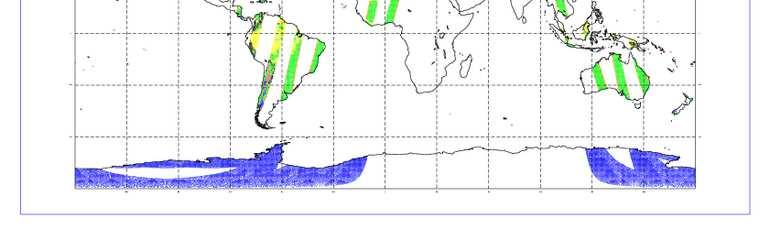
12 Quality Control ASCAT data is rejected from regions with: Snow Frost Wetlands Mountains Dense Vegetation (e.g. Amazon) Sand Dunes ASCAT data is rejected from the edges of the swaths. Cross-track cells: 1-4, 40-43, A background check is also applied (Lorenc and Hammon,1988). Rejects observations with large o-b

13 Quality Control
14 Assimilation A simple nudging scheme is used to assimilate the ASCAT derived soil moisture. Only the UM soil level 1 is nudged Observations of Screen Temperature and Humidity are also used to nudge the UM soil moisture in all UM soil levels. The ASCAT nudging is applied second.
15 RMS (o-b) stats The UM is able to retain the information from the data assimilation and the UM soil moisture converges towards the values derived from ASCAT.
16 Impact on the Global NWP Index Trial from May-July 2009 vs obs vs anal RMS errors in NH PMSL are reduced, at T+120 by 0.8%.
17 Tropics: RMS errors in screen T and RH (1 month) Control Test with ASCAT soil wetness assimilation Screen Temperature Screen Relative Humidity
18 Australia: RMS errors in screen T and RH (1 month) Control Test with ASCAT soil wetness assimilation Screen Temperature Screen Relative Humidity
19 North America: RMS errors in screen T and RH (1 month) Control Test with ASCAT soil wetness assimilation Screen Temperature Screen Relative Humidity
20 Europe: RMS errors in screen T and RH (1 month) Control Test with ASCAT soil wetness assimilation Screen Temperature Screen Relative Humidity


21 Difference in time mean Unified Model top level volumetric soil moisture (test control) ASCAT dries out the Sahara and Western United States. Volumetric soil moisture (m^3/m^3)

22 Water anomalies: 9 to 11 July 2009 ASCAT surface soil wetness anomaly River Flow anomaly


23 Water anomalies: 9 to 11 July 2009 Control run: top 10cm UM soil moisture anomaly ASCAT surface soil wetness anomaly Test run: top 10cm UM soil moisture anomaly River Flow anomaly

24 Western US: Utah Ground based observations Control: UM soil moisture without ASCAT assimilation Test: UM soil moisture with ASCAT assimilation
25 Western US: Utah Ground based observations Control: UM soil moisture without ASCAT assimilation Test: UM soil moisture with ASCAT assimilation
26 Eastern US: Mississippi Test: UM soil moisture with ASCAT assimilation Ground based observations Control: UM soil moisture without ASCAT assimilation
27 Eastern US: Mississippi Test: UM soil moisture with ASCAT assimilation Ground based observations Control: UM soil moisture without ASCAT assimilation
28 Conclusions We have implemented a simple and cheap method to assimilate measurements of ASCAT soil wetness (operational since 14 th July 2010). Our pre-operational trials indicates that ASCAT soil wetness assimilation improves forecasts of screen temperature and humidity for the tropics. Impact in other regions is slightly positive or neutral. Comparison against ground based soil moisture observations also indicates an improvement in model soil moisture. We are planning the development of a Kalman Filter based land DA scheme that can propagate surface information into the deeper soil levels.
29 Conclusions (2) Technical Report available (Dharssi et al., 2010) Tests of new EUMETSAT ASCAT pre-processing in progress
30 Questions?
31 Summary ASCAT soil wetness assimilation implemented operationally on 14 th July Assimilation method is simple and cheap. Only the level 1 soil moisture is nudged. Other Met Centres are developing Kalman Filters that can propagate surface information into the deeper soil levels. Kalman Filters are computationally expensive and so far only show a neutral impact for NWP. Our pre-operational trials indicate that ASCAT soil wetness assimilation improves forecasts of screen temperature and humidity for the tropics. Impact in other regions is slightly positive or neutral. Impact on the global NWP Index is neutral/slightly positive.
32 Technical Report
33 Why do we care about soil moisture? Soil moisture, together with other land properties, has a significant impact on forecasts of screen temperature and humidity. Affects the global NWP Index through it s impact on forecasts of mean sea level pressure. Influences the exchange of heat and moisture between the atmosphere and land surface. Soil moisture affects evaporation from plants and bare soil. Soil moisture affects the soil heat capacity and soil thermal conductivity and thus the ground heat flux. Potentially also important for forecasts of clouds and precipitation.
34 Why don t we use ground based measurements of soil moisture? Currently, a global ground based soil moisture observation network does not exist. One reason is that soil moisture can vary significantly over short distances and so measurements made at one location are not so informative about conditions at nearby locations. Some regional networks do exist but getting near realtime data is difficult and unreliable. Regional Soil Moisture observing networks are very useful for verification.
35 Current Soil Moisture Analysis Scheme At present we use observations of screen temperature and humidity to analyse soil moisture A nudging scheme ECMWF, Meteo-France and other Met Centres also use observations of screen temperature and humidity for their soil moisture analysis
36 Satellite based measurements of soil moisture (1) Remote sensing by satellites is attractive since satellites offer global data coverage. Horizontal resolution is similar to that of global NWP models ~ 25 km. At microwave frequencies the dielectric constant of liquid water (~80) is much higher than that of the soil mineral particles (< 5 ) or ice. An increase in soil moisture leads to an increase in the dielectric constant of the soil. Active system: The soil dielectric constant affects the backscatter from the soil. Passive system: The soil dielectric constant affects the soil emissivity and consequently the brightness temperature.

37 Passive Systems Active Systems
38 Comparison of Satellites AMSRE Advanced Microwave Scanning Radiometer EOS ASCAT Advanced SCATterometer Passive Active Passive 6.9 GHz (C band) 10.7 GHz (X band) Radio Frequency Interference (RFI) in the C band SMOS Soil Moisture Ocean Salinity 5.3 GHz (C band) 1.4 GHz (L band) No known RFI problems RFI problems detected ~ 60 km (C) 25 and 50 km ~ 40 km ~ 40 km (X) Global coverage < 2 days Daily coverage 82% 2002 to 2014 (?) 2006 to 2020 (at least) Repeat cycle < 3 days 2009 to 2012/14
39 Satellite based measurements of soil moisture (2) Satellites microwave sensors only sense a thin top layer of soil a few cm for L band ~1cm for C band a few mm for X band Microwave backscatter/brightness temperature is affected by many factors, including: Vegetation water content Soil roughness Lower frequencies are less affected so SMOS should be more accurate than ASCAT and AMSR-E.
40 Challenges to using Satellite derived soil moisture for NWP 1. Satellites only sense a thin top layer of soil; ~1cm. 2. Satellites don t measure soil moisture! Accurate retrieval algorithms are needed to convert satellite measurements of backscatter/brightness temperature into soil moisture. 3. Land surface models contain biases and approximations so assimilating more accurate soil moisture may make the NWP model s surface fluxes of heat and moisture worse and therefore make forecasts worse. i. Improving the land surface model and parameters is as important as improving the land data assimilation. ii. For example, introduction of Soil Moisture Nudging highlighted several deficiencies with the land surface model that were resolved at PS18.

41 Improvement in forecasts of Screen Temperature from PS18 (Apr 2008)
42 Satellites only sense a thin top layer of soil; ~1cm. For NWP we require knowledge of soil moisture in the plant root-zone (~ top 1m of soil) since plants extract soil water through the roots which then evaporates from their leaves. There are often significant vertical gradients in the soil moisture. In the summer the surface soil can become very dry while the deep soil layers are close to saturation.
43 Variation of soil moisture with depth: measurements from in-situ sensors at a station in Virginia state, US. Soil Moisture at 100cm Soil Moisture at 10cm Soil Moisture at 5cm
44 Variation of soil moisture with depth: measurements from in-situ sensors at a station in Alabama state, US. Soil Moisture at 100cm Soil Moisture at 10cm Soil Moisture at 5cm
45 Variation of soil moisture with depth: measurements from in-situ sensors at a station in Mississippi state, US. Soil Moisture at 100cm Soil Moisture at 10cm Soil Moisture at 5cm
46 Soil moisture retrieval algorithms Experience with AMSR-E shows that most soil moisture retrieval algorithms give poor results. The daily AMSR-E soil moisture product provided by the National Snow and Ice Data Centre (NSIDC) has a very low correlation with ground based measurements. The AMSR-E soil moisture product provided by the University of Amsterdam (VUA) has a high correlation with ground based measurements. This product seems to be released with a six-month delay.
47 Comparison of AMSR-E Retrieval Algorithms (X-band) Stats for retrieved soil moisture vs ground based soil moisture observations. Adelong, Australia (2006). Courtesy of Clara Draper. NSIDC-NASA VUA-NASA JAXA USDA Njoku et al (2003) Owe et al (2001) Koike et al (2004) Correlation RMS (m^3/m^3) Jackson et al (1993) SMOSREX, France ( ). Rudiger et al (2009) NSIDC-NASA VUA-NASA JAXA USDA Njoku et al (2003) Owe et al (2001) Koike et al (2004) Correlation N/A N/A RMS (normalised soil moisture) N/A N/A Jackson et al (1993)
48 from Jackson et al (2006) Arizona Oklahoma USDA JAXA NSIDC USDA JAXA NSIDC
49 How Does the UM use soil moisture? Evaporation from plants E = ρ R = s, veg q R + R a s R min s β veg, veg E ρ q R a Evaporation Density of Air Difference in Specific Humidity between the surface and model level 1 Aerodynamic Resistance between the surface and model level 1
50 Bulk Stomatal Resistance R = s, veg R min s β veg Calculated by a photosynthesis model and depends on vegetation type, temperature, humidity and incident solar radiation. The soil moisture availability depends on soil moisture, plant root fraction and soil texture. Soil texture is primarily determined by the size distribution of the soil particles.
51 Soil Moisture Availability β 4 = β = veg f k veg, k k = 1 k =1 4 f k 1 β veg, k = θ θ k c 0 1 θ θ w w θ w θ θ k < k < θ θ > k θ w < c θ c θk Soil Moisture in soil level k θw θc Wilting Point Critical Point
52 Wilting and Critical Points The wilting point and critical point are as important as the soil moisture in controlling evaporation from plants. The wilting point and critical point are determined by the soil texture. Therefore, soil texture is as important as soil moisture. Therefore, to improve the model soil moisture we also have to improve the model soil texture and soil hydraulic parameters (and other land parameters). For example, include the vertical variation of soil texture in the UM.
Assimilation of satellite derived soil moisture for weather forecasting
 Assimilation of satellite derived soil moisture for weather forecasting www.cawcr.gov.au Imtiaz Dharssi and Peter Steinle February 2011 SMOS/SMAP workshop, Monash University Summary In preparation of the
Land Data Assimilation for operational weather forecasting
 Land Data Assimilation for operational weather forecasting Brett Candy Richard Renshaw, JuHyoung Lee & Imtiaz Dharssi * *Centre Australian Weather and Climate Research Contents An overview of the Current
Updates to Land DA at the Met Office
 Updates to Land DA at the Met Office Brett Candy & Keir Bovis Satellite Soil Moisture Workshop, Amsterdam, 10th July 2014 Land DA - The Story So Far - Kalman Filter 18 months in operations - Analyses of
New soil physical properties implemented in the Unified Model
 New soil physical properties implemented in the Unified Model Imtiaz Dharssi 1, Pier Luigi Vidale 3, Anne Verhoef 3, Bruce Macpherson 1, Clive Jones 1 and Martin Best 2 1 Met Office (Exeter, UK) 2 Met
ECMWF. ECMWF Land Surface Analysis: Current status and developments. P. de Rosnay M. Drusch, K. Scipal, D. Vasiljevic G. Balsamo, J.
 Land Surface Analysis: Current status and developments P. de Rosnay M. Drusch, K. Scipal, D. Vasiljevic G. Balsamo, J. Muñoz Sabater 2 nd Workshop on Remote Sensing and Modeling of Surface Properties,
The Application of Satellite Data i n the Global Surface Data Assimil ation System at KMA
 The Application of Satellite Data i n the Global Surface Data Assimil ation System at KMA Mee-Ja Kim, Hae-Mi Noh, SeiYoung Park, Sangwon Joo KMA/NIMS kimmee74@korea.kr 14 March, 2016 The 4th Workshop on
ECMWF. ECMWF Land Surface modelling and land surface analysis. P. de Rosnay G. Balsamo S. Boussetta, J. Munoz Sabater D.
 Land Surface modelling and land surface analysis P. de Rosnay G. Balsamo S. Boussetta, J. Munoz Sabater D. Vasiljevic M. Drusch, K. Scipal SRNWP 12 June 2009 Slide 1 Surface modelling (G. Balsamo) HTESSEL,
Evaluation of remotely sensed and modelled soil moisture products using global ground-based in situ observations
 Evaluation of remotely sensed and modelled soil moisture products using global ground-based in situ observations C. Albergel (1), P. de Rosnay (1), G. Balsamo (1),J. Muñoz-Sabater(1 ), C. Gruhier (2),
Use of satellite soil moisture information for NowcastingShort Range NWP forecasts
 Use of satellite soil moisture information for NowcastingShort Range NWP forecasts Francesca Marcucci1, Valerio Cardinali/Paride Ferrante1,2, Lucio Torrisi1 1 COMET, Italian AirForce Operational Center
Assimilation of land surface satellite data for Numerical Weather Prediction at ECMWF
 4 th workshop on Remote Sensing and Modelling of Surface properties Saint Martin d Hères, 14-16 March 2016 Assimilation of land surface satellite data for Numerical Weather Prediction at ECMWF P. de Rosnay,
RETRIEVAL OF SOIL MOISTURE OVER SOUTH AMERICA DERIVED FROM MICROWAVE OBSERVATIONS
 2nd Workshop on Remote Sensing and Modeling of Surface Properties 9-11 June 2009, Toulouse, France Météo France Centre International de Conférences RETRIEVAL OF SOIL MOISTURE OVER SOUTH AMERICA DERIVED
Remotely Sensed Soil Moisture over Australia from AMSR-E
 Remotely Sensed Soil Moisture over Australia from AMSR-E Draper, C. S. 1,2, J.P. Walker 1, P.J. Steinle 2, R.A.M. de Jeu 3, and T.R.H. Holmes 3 1 Department of Civil and Environmental Engineering, University
Ocean Vector Winds in Storms from the SMAP L-Band Radiometer
 International Workshop on Measuring High Wind Speeds over the Ocean 15 17 November 2016 UK Met Office, Exeter Ocean Vector Winds in Storms from the SMAP L-Band Radiometer Thomas Meissner, Lucrezia Ricciardulli,
High resolution land reanalysis
 Regional Reanalysis Workshop 19-20 May 2016, Reading High resolution land reanalysis P. de Rosnay, G. Balsamo, J. Muñoz Sabater, E. Dutra, C. Albergel, N. Rodríguez-Fernández, H. Hersbach Introduction:
Soil Moisture Prediction and Assimilation
 Soil Moisture Prediction and Assimilation Analysis and Prediction in Agricultural Landscapes Saskatoon, June 19-20, 2007 STEPHANE BELAIR Meteorological Research Division Prediction and Assimilation Atmospheric
The assimilation of AMSU and SSM/I brightness temperatures in clear skies at the Meteorological Service of Canada
 The assimilation of AMSU and SSM/I brightness temperatures in clear skies at the Meteorological Service of Canada Abstract David Anselmo and Godelieve Deblonde Meteorological Service of Canada, Dorval,
F O U N D A T I O N A L C O U R S E
 F O U N D A T I O N A L C O U R S E December 6, 2018 Satellite Foundational Course for JPSS (SatFC-J) F O U N D A T I O N A L C O U R S E Introduction to Microwave Remote Sensing (with a focus on passive
Aquarius/SAC-D Soil Moisture Product using V3.0 Observations
 Aquarius/SAC-D Soil Moisture Product using V3. Observations R. Bindlish, T. Jackson, M. Cosh November 214 Overview Soil moisture algorithm Soil moisture product Validation Linkage between Soil Moisture
REVISION OF THE STATEMENT OF GUIDANCE FOR GLOBAL NUMERICAL WEATHER PREDICTION. (Submitted by Dr. J. Eyre)
") WORLD METEOROLOGICAL ORGANIZATION Distr.: RESTRICTED CBS/OPAG-IOS (ODRRGOS-5)/Doc.5, Add.5 (11.VI.2002) COMMISSION FOR BASIC SYSTEMS OPEN PROGRAMME AREA GROUP ON INTEGRATED OBSERVING SYSTEMS ITEM: 4 EXPERT
WORLD METEOROLOGICAL ORGANIZATION Distr.: RESTRICTED CBS/OPAG-IOS (ODRRGOS-5)/Doc.5, Add.5 (11.VI.2002) COMMISSION FOR BASIC SYSTEMS OPEN PROGRAMME AREA GROUP ON INTEGRATED OBSERVING SYSTEMS ITEM: 4 EXPERT
ASSIMILATION OF CLOUDY AMSU-A MICROWAVE RADIANCES IN 4D-VAR 1. Stephen English, Una O Keeffe and Martin Sharpe
 ASSIMILATION OF CLOUDY AMSU-A MICROWAVE RADIANCES IN 4D-VAR 1 Stephen English, Una O Keeffe and Martin Sharpe Met Office, FitzRoy Road, Exeter, EX1 3PB Abstract The assimilation of cloud-affected satellite
Toward improving the representation of the water cycle at High Northern Latitudes
 Toward improving the representation of the water cycle at High Northern Latitudes W. A. Lahoz a, T. M. Svendby a, A. Griesfeller a, J. Kristiansen b a NILU, Kjeller, Norway b Met Norway, Oslo, Norway wal@nilu.no
Extended Kalman Filter soil-moisture analysis in the IFS
 from Newsletter Number 127 Spring 211 METEOROLOGY Extended Kalman Filter soil-moisture analysis in the IFS doi:1.21957/ik7co53s This article appeared in the Meteorology section of ECMWF Newsletter No.
Scatterometer Wind Assimilation at the Met Office
 Scatterometer Wind Assimilation at the Met Office James Cotton International Ocean Vector Winds Science Team (IOVWST) meeting, Brest, June 2014 Outline Assimilation status Global updates: Metop-B and spatial
Satellite Soil Moisture in Research Applications
 Satellite Soil Moisture in Research Applications Richard de Jeu richard.de.jeu@falw.vu.nl Thomas Holmes, Hylke Beck, Guojie Wang, Han Dolman (VUA) Manfred Owe (NASA-GSFC) Albert Van Dijk, Yi Liu (CSIRO)
Assimilation of IASI data at the Met Office. Fiona Hilton Nigel Atkinson ITSC-XVI, Angra dos Reis, Brazil 07/05/08
 Assimilation of IASI data at the Met Office Fiona Hilton Nigel Atkinson ITSC-XVI, Angra dos Reis, Brazil 07/05/08 Thanks to my other colleagues! Andrew Collard (ECMWF) Brett Candy, Steve English, James
SMAP and SMOS Integrated Soil Moisture Validation. T. J. Jackson USDA ARS
 SMAP and SMOS Integrated Soil Moisture Validation T. J. Jackson USDA ARS Perspective Linkage of SMOS and SMAP soil moisture calibration and validation will have short and long term benefits for both missions.
Direct assimilation of all-sky microwave radiances at ECMWF
 Direct assimilation of all-sky microwave radiances at ECMWF Peter Bauer, Alan Geer, Philippe Lopez, Deborah Salmond European Centre for Medium-Range Weather Forecasts Reading, Berkshire, UK Slide 1 17
The Canadian Land Data Assimilation System (CaLDAS)
") The Canadian Land Data Assimilation System (CaLDAS) Marco L. Carrera, Stéphane Bélair, Bernard Bilodeau and Sheena Solomon Meteorological Research Division, Environment Canada Dorval, QC, Canada 2 nd Workshop
The Canadian Land Data Assimilation System (CaLDAS) Marco L. Carrera, Stéphane Bélair, Bernard Bilodeau and Sheena Solomon Meteorological Research Division, Environment Canada Dorval, QC, Canada 2 nd Workshop
Towards a better use of AMSU over land at ECMWF
 Towards a better use of AMSU over land at ECMWF Blazej Krzeminski 1), Niels Bormann 1), Fatima Karbou 2) and Peter Bauer 1) 1) European Centre for Medium-range Weather Forecasts (ECMWF), Shinfield Park,
Development of the Canadian Precipitation Analysis (CaPA) and the Canadian Land Data Assimilation System (CaLDAS)
 and the Canadian Land Data Assimilation System (CaLDAS)") Development of the Canadian Precipitation Analysis (CaPA) and the Canadian Land Data Assimilation System (CaLDAS) Marco L. Carrera, Vincent Fortin and Stéphane Bélair Meteorological Research Division Environment
Development of the Canadian Precipitation Analysis (CaPA) and the Canadian Land Data Assimilation System (CaLDAS) Marco L. Carrera, Vincent Fortin and Stéphane Bélair Meteorological Research Division Environment
Outline. Part I (Monday) Part II (Tuesday) ECMWF. Introduction Snow analysis Screen level parameters analysis
 Part II (Tuesday) ECMWF. Introduction Snow analysis Screen level parameters analysis") Outline Part I (Monday) Introduction Snow analysis Screen level parameters analysis Part II (Tuesday) Soil moisture analysis OI and EKF analyses Use of satellite data: ASCAT and SMOS Summary and future
Outline Part I (Monday) Introduction Snow analysis Screen level parameters analysis Part II (Tuesday) Soil moisture analysis OI and EKF analyses Use of satellite data: ASCAT and SMOS Summary and future
Extending the use of surface-sensitive microwave channels in the ECMWF system
 Extending the use of surface-sensitive microwave channels in the ECMWF system Enza Di Tomaso and Niels Bormann European Centre for Medium-range Weather Forecasts Shinfield Park, Reading, RG2 9AX, United
Soil moisture Product and science update
 Soil moisture Product and science update Wouter Dorigo and colleagues Department of Geodesy and Geo-information, Vienna University of Technology, Vienna, Austria 2 June 2013 Soil moisture is getting mature
GCOM-W1 now on the A-Train
 GCOM-W1 now on the A-Train GCOM-W1 Global Change Observation Mission-Water Taikan Oki, K. Imaoka, and M. Kachi JAXA/EORC (& IIS/The University of Tokyo) Mini-Workshop on A-Train Science, March 8 th, 2013
A two-season impact study of the Navy s WindSat surface wind retrievals in the NCEP global data assimilation system
 A two-season impact study of the Navy s WindSat surface wind retrievals in the NCEP global data assimilation system Li Bi James Jung John Le Marshall 16 April 2008 Outline WindSat overview and working
A SATELLITE LAND DATA ASSIMILATION SYTEM COUPLED WITH A MESOSCALE MODEL: TOWARDS IMPROVING NUMERICAL WEATHER PREDICTION
 A SATELLITE LAND DATA ASSIMILATION SYTEM COUPLED WITH A MESOSCALE MODEL: TOWARDS IMPROVING NUMERICAL WEATHER PREDICTION Mohamed Rasmy*, Toshio Koike*, Souhail Bousseta**, Xin Li*** Dept. of Civil Engineering,
Root zone soil moisture from the assimilation of screen level variables and remotely sensed soil moisture
 JOURNAL OF GEOPHYSICAL RESEARCH, VOL. 116,, doi:10.1029/2010jd013829, 2011 Root zone soil moisture from the assimilation of screen level variables and remotely sensed soil moisture C. S. Draper, 1,2 J.
STATUS ON THE USE OF SCATTEROMETER DATA AT METEO FRANCE
 STATUS ON THE USE OF SCATTEROMETER DATA AT METEO FRANCE Christophe Payan Centre National de Recherches Météorologiques, M CNRS-GAME CNRS and Météo-France Toulouse, France 9th International Winds Workshop,
Presentation of met.no s experience and expertise related to high resolution reanalysis
 Presentation of met.no s experience and expertise related to high resolution reanalysis Oyvind Saetra, Ole Einar Tveito, Harald Schyberg and Lars Anders Breivik Norwegian Meteorological Institute Daily
Name the surface winds that blow between 0 and 30. GEO 101, February 25, 2014 Monsoon Global circulation aloft El Niño Atmospheric water
 GEO 101, February 25, 2014 Monsoon Global circulation aloft El Niño Atmospheric water Name the surface winds that blow between 0 and 30 What is the atmospheric pressure at 0? What is the atmospheric pressure
Assimilation of ASCAT soil moisture products into the SIM hydrological platform
 Assimilation of ASCAT soil moisture products into the SIM hydrological platform H-SAF Associated Scientist Program (AS09_01) Final Report 23 December 2010 Draper, C., Mahfouf, J.-F., Calvet, J.-C., and
Long term performance monitoring of ASCAT-A
 Long term performance monitoring of ASCAT-A Craig Anderson and Julia Figa-Saldaña EUMETSAT, Eumetsat Allee 1, 64295 Darmstadt, Germany. Abstract The Advanced Scatterometer (ASCAT) on the METOP series of
Recent Data Assimilation Activities at Environment Canada
 Recent Data Assimilation Activities at Environment Canada Major upgrade to global and regional deterministic prediction systems (now in parallel run) Sea ice data assimilation Mark Buehner Data Assimilation
Introduction to SMAP. ARSET Applied Remote Sensing Training. Jul. 20,
 National Aeronautics and Space Administration ARSET Applied Remote Sensing Training http://arset.gsfc.nasa.gov @NASAARSET Introduction to SMAP Jul. 20, 2016 www.nasa.gov Outline 1. Mission objectives 2.
3850 IEEE JOURNAL OF SELECTED TOPICS IN APPLIED EARTH OBSERVATIONS AND REMOTE SENSING, VOL. 10, NO. 9, SEPTEMBER 2017
 3850 IEEE JOURNAL OF SELECTED TOPICS IN APPLIED EARTH OBSERVATIONS AND REMOTE SENSING, VOL. 10, NO. 9, SEPTEMBER 2017 Comparison of X-Band and L-Band Soil Moisture Retrievals for Land Data Assimilation
OSI SAF Sea Ice products
 OSI SAF Sea Ice products Lars-Anders Brevik, Gorm Dybkjær, Steinar Eastwood, Øystein Godøy, Mari Anne Killie, Thomas Lavergne, Rasmus Tonboe, Signe Aaboe Norwegian Meteorological Institute Danish Meteorological
Remote sensing of sea ice
 Remote sensing of sea ice Ice concentration/extent Age/type Drift Melting Thickness Christian Haas Remote Sensing Methods Passive: senses shortwave (visible), thermal (infrared) or microwave radiation
Lecture 19: Operational Remote Sensing in Visible, IR, and Microwave Channels
 MET 4994 Remote Sensing: Radar and Satellite Meteorology MET 5994 Remote Sensing in Meteorology Lecture 19: Operational Remote Sensing in Visible, IR, and Microwave Channels Before you use data from any
SIMULATION OF SPACEBORNE MICROWAVE RADIOMETER MEASUREMENTS OF SNOW COVER FROM IN-SITU DATA AND EMISSION MODELS
 SIMULATION OF SPACEBORNE MICROWAVE RADIOMETER MEASUREMENTS OF SNOW COVER FROM IN-SITU DATA AND EMISSION MODELS Anna Kontu 1 and Jouni Pulliainen 1 1. Finnish Meteorological Institute, Arctic Research,
EUMETSAT STATUS AND PLANS
 1 EUM/TSS/VWG/15/826793 07/10/2015 EUMETSAT STATUS AND PLANS François Montagner, Marine Applications Manager, EUMETSAT WMO Polar Space Task Group 5 5-7 October 2015, DLR, Oberpfaffenhofen PSTG Strategic
An Intercomparison of ERS-Scat and AMSR-E Soil Moisture Observations with Model Simulations over France
 APRIL 2009 R Ü DIGER ET AL. 431 An Intercomparison of ERS-Scat and AMSR-E Soil Moisture Observations with Model Simulations over France CHRISTOPH RÜDIGER* AND JEAN-CHRISTOPHE CALVET CNRM-GAME, Météo-France/CNRS,
Satellite data for hydrological forecasting
 Satellite data for hydrological forecasting Current use at ECMWF and perspective Shopping list! Our current tools does not allow direct use, but could be modified Christel Prudhomme Christel.prudhomme@ecmwf.int
Impact of METOP ASCAT Ocean Surface Winds in the NCEP GDAS/GFS and NRL NAVDAS
 Impact of METOP ASCAT Ocean Surface Winds in the NCEP GDAS/GFS and NRL NAVDAS COAMPS @ Li Bi 1,2 James Jung 3,4 Michael Morgan 5 John F. Le Marshall 6 Nancy Baker 2 Dave Santek 3 1 University Corporation
Land data assimilation in the NASA GEOS-5 system: Status and challenges
 Blueprints for Next-Generation Data Assimilation Systems Boulder, CO, USA 8-10 March 2016 Land data assimilation in the NASA GEOS-5 system: Status and challenges Rolf Reichle Clara Draper, Ricardo Todling,
This article appeared in a journal published by Elsevier. The attached copy is furnished to the author for internal non-commercial research and
 This article appeared in a journal published by Elsevier. The attached copy is furnished to the author for internal non-commercial research and education use, including for instruction at the authors institution
Assimilation of passive and active microwave soil moisture retrievals
 GEOPHYSICAL RESEARCH LETTERS, VOL. 39,, doi:10.1029/2011gl050655, 2012 Assimilation of passive and active microwave soil moisture retrievals C. S. Draper, 1,2 R. H. Reichle, 1 G. J. M. De Lannoy, 1,2,3
Can assimilating remotely-sensed surface soil moisture data improve root-zone soil moisture predictions in the CABLE land surface model?
 19th International Congress on Modelling and Simulation, Perth, Australia, 12 16 December 2011 http://mssanz.org.au/modsim2011 Can assimilating remotely-sensed surface soil moisture data improve root-zone
Evaluation of an emissivity module to improve the simulation of L-band brightness temperature over desert regions with CMEM
 Evaluation of an emissivity module to improve the simulation of L-band brightness temperature over desert regions with CMEM Martin Lange, DWD Germany Patricia de Rosnay, ECMWF Yudong Tian, NASA Goddard
Land surface data assimilation for Numerical Weather Prediction
 Sixth WMO Symposium on Data Assimilation, University of Maryland, 7-11 October 2013 Land surface data assimilation for Numerical Weather Prediction P. de Rosnay, J. Muñoz Sabater, C. Albergel, G. Balsamo,
Current Limited Area Applications
 Current Limited Area Applications Nils Gustafsson SMHI Norrköping, Sweden nils.gustafsson@smhi.se Outline of talk (contributions from many HIRLAM staff members) Specific problems of Limited Area Model
Use of AMSU data in the Met Office UK Mesoscale Model
 Use of AMSU data in the Met Office UK Mesoscale Model 1. Introduction Brett Candy, Stephen English, Richard Renshaw & Bruce Macpherson The Met Office, Exeter, United Kingdom In common with other global
Climate data records from OSI SAF scatterometer winds. Anton Verhoef Jos de Kloe Jeroen Verspeek Jur Vogelzang Ad Stoffelen
 Climate data records from OSI SAF scatterometer winds Anton Verhoef Jos de Kloe Jeroen Verspeek Jur Vogelzang Ad Stoffelen Outline Motivation Planning Preparation and methods Quality Monitoring Output
Satellite Radiance Data Assimilation at the Met Office
 Satellite Radiance Data Assimilation at the Met Office Ed Pavelin, Stephen English, Brett Candy, Fiona Hilton Outline Summary of satellite data used in the Met Office NWP system Processing and quality
Accuracy Issues Associated with Satellite Remote Sensing Soil Moisture Data and Their Assimilation
 Proceedings of the 8th International Symposium on Spatial Accuracy Assessment in Natural Resources and Environmental Sciences Shanghai, P. R. China, June 25-27, 2008, pp. 213-220 Accuracy Issues Associated
Cliquez pour modifier le style des sous-titres du masque
 Techniques for modelling land, snow and sea ice emission and scattering in support of data assimilation Fatima Karbou CNRM-GAME, Cliquez pour modifier le stylemétéo-france du titre & CNRS Saint Martin
Assimilating AMSU-A over Sea Ice in HIRLAM 3D-Var
 Abstract Assimilating AMSU-A over Sea Ice in HIRLAM 3D-Var Vibeke W. Thyness 1, Leif Toudal Pedersen 2, Harald Schyberg 1, Frank T. Tveter 1 1 Norwegian Meteorological Institute (met.no) Box 43 Blindern,
Soil frost from microwave data. Kimmo Rautiainen, Jouni Pulliainen, Juha Lemmetyinen, Jaakko Ikonen, Mika Aurela
 Soil frost from microwave data Kimmo Rautiainen, Jouni Pulliainen, Juha Lemmetyinen, Jaakko Ikonen, Mika Aurela Why landscape freeze/thaw? Latitudinal variation in mean correlations (r) between annual
Using satellite-derived snow cover data to implement a snow analysis in the Met Office global NWP model
 Using satellite-derived snow cover data to implement a snow analysis in the Met Office global NWP model Pullen, C Jones, and G Rooney Met Office, Exeter, UK amantha.pullen@metoffice.gov.uk 1. Introduction
Remote sensing with FAAM to evaluate model performance
 Remote sensing with FAAM to evaluate model performance YOPP-UK Workshop Chawn Harlow, Exeter 10 November 2015 Contents This presentation covers the following areas Introduce myself Focus of radiation research
Microwave Remote Sensing of Sea Ice
 Microwave Remote Sensing of Sea Ice What is Sea Ice? Passive Microwave Remote Sensing of Sea Ice Basics Sea Ice Concentration Active Microwave Remote Sensing of Sea Ice Basics Sea Ice Type Sea Ice Motion
IMPORTANCE OF SATELLITE DATA (FOR REANALYSIS AND BEYOND) Jörg Schulz EUMETSAT
 Jörg Schulz EUMETSAT") IMPORTANCE OF SATELLITE DATA (FOR REANALYSIS AND BEYOND) Jörg Schulz EUMETSAT Why satellite data for climate monitoring? Global coverage Global consistency, sometimes also temporal consistency High spatial
IMPORTANCE OF SATELLITE DATA (FOR REANALYSIS AND BEYOND) Jörg Schulz EUMETSAT Why satellite data for climate monitoring? Global coverage Global consistency, sometimes also temporal consistency High spatial
The SMOS Satellite Mission. Y. Kerr, and the SMOS Team
 The SMOS Satellite Mission Y. Kerr, and the SMOS Team The 4 phases of a project The concept Expression of needs Theoretical solution Practical solution The selling Proposal writing Concept fine tuning
Climate Models and Snow: Projections and Predictions, Decades to Days
 Climate Models and Snow: Projections and Predictions, Decades to Days Outline Three Snow Lectures: 1. Why you should care about snow 2. How we measure snow 3. Snow and climate modeling The observational
Question 1: Do you have any comments on our approach to this review?:
 Question 1: Do you have any comments on our approach to this review?: No. Question 2: Do you have any comments on our broad overview of the satellite sector set out in this section? In particular, do you
How can flux-tower nets improve weather forecast and climate models?
 How can flux-tower nets improve weather forecast and climate models? Alan K. Betts Atmospheric Research, Pittsford, VT akbetts@aol.com Co-investigators BERMS Data: Alan Barr, Andy Black, Harry McCaughey
Towards a Kalman Filter based soil moisture analysis system for the operational ECMWF Integrated Forecast System
 GEOPHYSICAL RESEARCH LETTERS, VOL. 36, L10401, doi:10.1029/2009gl037716, 2009 Towards a Kalman Filter based soil moisture analysis system for the operational ECMWF Integrated Forecast System M. Drusch,
Summary of activities with SURFEX data assimilation at Météo-France. Jean-François MAHFOUF CNRM/GMAP/OBS
 Summary of activities with SURFEX data assimilation at Météo-France Jean-François MAHFOUF CNRM/GMAP/OBS Outline Status at Météo-France in 2008 Developments undertaken during 2009-2011 : Extended Kalman
Current status of lake modelling and initialisation at ECMWF
 Current status of lake modelling and initialisation at ECMWF G Balsamo, A Manrique Suñen, E Dutra, D. Mironov, P. Miranda, V Stepanenko, P Viterbo, A Nordbo, R Salgado, I Mammarella, A Beljaars, H Hersbach
Terrestrial Snow Cover: Properties, Trends, and Feedbacks. Chris Derksen Climate Research Division, ECCC
 Terrestrial Snow Cover: Properties, Trends, and Feedbacks Chris Derksen Climate Research Division, ECCC Outline Three Snow Lectures: 1. Why you should care about snow: Snow and the cryosphere Classes of
The NASA Soil Moisture Active Passive Mission (SMAP) Status and Early Results
 Status and Early Results") 20154 California Institute of Technology. Government sponsorship acknowledged. National Aeronautics and Space Administration The NASA Soil Moisture Active Passive Mission (SMAP) Status and Early Results
20154 California Institute of Technology. Government sponsorship acknowledged. National Aeronautics and Space Administration The NASA Soil Moisture Active Passive Mission (SMAP) Status and Early Results
Land Surface Processes and Their Impact in Weather Forecasting
 Land Surface Processes and Their Impact in Weather Forecasting Andrea Hahmann NCAR/RAL with thanks to P. Dirmeyer (COLA) and R. Koster (NASA/GSFC) Forecasters Conference Summer 2005 Andrea Hahmann ATEC
Related Improvements. A DFS Application. Mark A. Bourassa
 Related Improvements in Surface Turbulent Heat Fluxes A DFS Application Center for Ocean-Atmospheric Prediction Studies & Department of Earth, Ocean and Atmospheric Sciences, The Florida State University,
Instrumentation planned for MetOp-SG
 Instrumentation planned for MetOp-SG Bill Bell Satellite Radiance Assimilation Group Met Office Crown copyright Met Office Outline Background - the MetOp-SG programme The MetOp-SG instruments Summary Acknowledgements:
THORPEX Data Assimilation and Observing Strategies Working Group: scientific objectives
 THORPEX Data Assimilation and Observing Strategies Working Group: scientific objectives Pierre Gauthier Co-chair of the DAOS-WG Atmospheric Science and Technology Branch Environment Canada Data assimilation
Contents. 1. Evaporation
 Contents 1 Evaporation 1 1a Evaporation from Wet Surfaces................... 1 1b Evaporation from Wet Surfaces in the absence of Advection... 4 1c Bowen Ratio Method........................ 4 1d Potential
GPC Exeter forecast for winter Crown copyright Met Office
 GPC Exeter forecast for winter 2015-2016 Global Seasonal Forecast System version 5 (GloSea5) ensemble prediction system the source for Met Office monthly and seasonal forecasts uses a coupled model (atmosphere
An EKF assimilation of AMSR-E soil moisture into the ISBA land surface scheme
 JOURNAL OF GEOPHYSICAL RESEARCH, VOL. 114,, doi:10.1029/2008jd011650, 2009 An EKF assimilation of AMSR-E soil moisture into the ISBA land surface scheme C. S. Draper, 1 J.-F. Mahfouf, 2 and J. P. Walker
Bringing Consistency into High Wind Measurements with Spaceborne Microwave Radiometers and Scatterometers
 International Ocean Vector Wind Science Team Meeting May 2-4, 2017, Scripps Bringing Consistency into High Wind Measurements with Spaceborne Microwave Radiometers and Scatterometers Thomas Meissner, Lucrezia
1. Current atmospheric DA systems 2. Coupling surface/atmospheric DA 3. Trends & ideas
 1 Current issues in atmospheric data assimilation and its relationship with surfaces François Bouttier GAME/CNRM Météo-France 2nd workshop on remote sensing and modeling of surface properties, Toulouse,
PREDICTION AND MONITORING OF OCEANIC DISASTERS USING MICROWAVE REMOTE SENSING TECHNIQUES
 PREDICTION AND MONITORING OF OCEANIC DISASTERS USING MICROWAVE REMOTE SENSING TECHNIQUES O P N Calla International Centre for Radio Science, OM NIWAS A-23, Shastri Nagar, Jodhpur-342 003 Abstract The disasters
Satellite Soil Moisture Content Data Assimilation in Operational Local NWP System at JMA
 Satellite Soil Moisture Content Data Assimilation in Operational Local NWP System at JMA Yasutaka Ikuta Numerical Prediction Division Japan Meteorological Agency Acknowledgment: This research was supported
Long-term Water Cycle Observation by the Advanced Microwave Scanning Radiometer (AMSR) Series: AMSR-E, AMSR2 and Follow-on
 Series: AMSR-E, AMSR2 and Follow-on") Long-term Water Cycle Observation by the Advanced Microwave Scanning Radiometer (AMSR) Series: AMSR-E, AMSR2 and Follow-on M. Kachi 1), H. Fujii 1), T. Kubota 1), T. Maeda 1), N. Ono 1), M. Kasahara 1),
Long-term Water Cycle Observation by the Advanced Microwave Scanning Radiometer (AMSR) Series: AMSR-E, AMSR2 and Follow-on M. Kachi 1), H. Fujii 1), T. Kubota 1), T. Maeda 1), N. Ono 1), M. Kasahara 1),
The Canadian Precipitation Analysis (CaPA) and the Canadian Land Data Assimilation System (CaLDAS)
 and the Canadian Land Data Assimilation System (CaLDAS)") The Canadian Precipitation Analysis (CaPA) and the Canadian Land Data Assimilation System (CaLDAS) Vincent Fortin (and many collaborators) Division de la recherche en météorologie Environnement en Changement
The Canadian Precipitation Analysis (CaPA) and the Canadian Land Data Assimilation System (CaLDAS) Vincent Fortin (and many collaborators) Division de la recherche en météorologie Environnement en Changement
Stability in SeaWinds Quality Control
 Ocean and Sea Ice SAF Technical Note Stability in SeaWinds Quality Control Anton Verhoef, Marcos Portabella and Ad Stoffelen Version 1.0 April 2008 DOCUMENTATION CHANGE RECORD Reference: Issue / Revision:
Data Short description Parameters to be used for analysis SYNOP. Surface observations by ships, oil rigs and moored buoys
 3.2 Observational Data 3.2.1 Data used in the analysis Data Short description Parameters to be used for analysis SYNOP Surface observations at fixed stations over land P,, T, Rh SHIP BUOY TEMP PILOT Aircraft
Modelling and Data Assimilation Needs for improving the representation of Cold Processes at ECMWF
 Modelling and Data Assimilation Needs for improving the representation of Cold Processes at ECMWF presented by Gianpaolo Balsamo with contributions from Patricia de Rosnay, Richard Forbes, Anton Beljaars,
Parameterization of the surface emissivity at microwaves to submillimeter waves
 Parameterization of the surface emissivity at microwaves to submillimeter waves Catherine Prigent, Filipe Aires, Observatoire de Paris and Estellus Lise Kilic, Die Wang, Observatoire de Paris with contributions
Comparing the SEKF with the DEnKF on a land surface model
 Comparing the SEKF with the DEnKF on a land surface model David Fairbairn, Alina Barbu, Emiliano Gelati, Jean-Francois Mahfouf and Jean-Christophe Caret CNRM - Meteo France Partly funded by European Union
EUMETSAT LSA-SAF EVAPOTRANSPIRATION PRODUCTS STATUS AND PERSPECTIVES
 EUMETSAT LSA-SAF EVAPOTRANSPIRATION PRODUCTS STATUS AND PERSPECTIVES Arboleda, N. Ghilain, F. Gellens-Meulenberghs Royal Meteorological Institute, Avenue Circulaire, 3, B-1180 Bruxelles, BELGIUM Corresponding
Report. Northern Africa. RAIDEG-8, 1-2 Nov 2017
 Report Northern Africa RAIDEG-8, 1-2 Nov 2017 Report Northern Africa RAIDEG-8, 1-2 Nov 2017 Important Note: Formal letters have been sent from the PR of Morocco with WMO to PRs of Algeria, Tunisia, Libya