VIC Hydrology Model Training Workshop Part II: Building a model
|
|
|
- Rosemary Lang
- 6 years ago
- Views:
Transcription


1 VIC Hydrology Model Training Workshop Part II: Building a model Oct 2011 Centro de Cambio Global Pontificia Universidad Católica de Chile Ed Maurer Civil Engineering Department Santa Clara University Based on original workshop materials generously provided by Alan Hamlet, U. Washington, with contributions by A. Wood, J. Adam, T. Bohn, and F. Su.
2 Constructing a VIC model 1. Define region or basin 2. Select VIC modeling resolution Global typically 1/4-1 (25 km 100 km) Regional (where meteorological observations are dense) 1/16-1/4 (6 km 25 km) 3. Build land surface parameterization files* Elevation (grid cell mean and sub-grid bands) Soil (large input file) Vegetation/Land cover (library and parameter files) 4. Assemble driving meteorological data* Station data Gridded data Sub-grid variability *existing VIC setups are available globally and for some regions


3 Meteorological Forcing Files Running VIC in a nutshell VIC Snowbands File grid cell Vegetation File Global parameter file Model Routing Model Q observed Fraction File Flow Direct. File Xmask file Rout file Input Q simulated Q Slide courtesy of E. de Maria time


4 Defining modeling domain: Basin Select basin from existing data or Define rectangle of interest Select VIC modeling resolution Note: VIC doesn t know about basin boundaries you can model a larger area than needed, as long as it contains your basin


5 Pre-defined basin boundaries Hd Hydro1kis a popular data source derived from 1 km elevation data Newer HydroSheds data set is based on finer scale elevation data


6 Digital Elevation Models Hydro1k: equal area projection, 1 km resolution Gtopo30 or SRTM30: geographic projection, 30 arc-seconds (~ 1 km)
7 Newer, higher resolution elevation data Derived from elevation data of the Shuttle Radar Topography Mission (SRTM) at t3 arc-second resolution (~90m) Stream networks, watershed boundaries, flow direction and accumulation


8 Extract Elevation Information for Basin/Region Extract/clip elevation data to basin or region Project to geographic g (if necessary) Aggregate it to the VIC modeling resolution Retain fine-scale elevation data for elevation band definition (sub-grid scale detail)
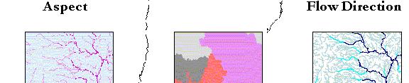
9 Elevation derivatives (available from Hydro1k and HydroSheds) From elevation data source, it may also be useful to download, for the identical domain: Basin boundaries Flow directions Flow accumulations Rivers While these can be derived d from elevation using GIS, obtaining from the same source guarantees consistency These can also be used in later processing steps.
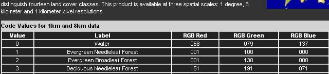
10 Describing Land Cover Two files describe this in VIC 1. Vegetation library file: describes hydrologically important characteristics of different land cover types 2. Vegetation parameter file: contains the spatial variability of land cover


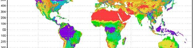
11 Land Cover Classification U. Maryland AVHRR, 1 km global product md /data/landco er/ IGBP global product


 Available in gridded format at 1/4 spatial")
12 Sources of land cover parameters Literature Many potential sources Use functions to derive from NDVI gov/nldas/web/web veg table html Assembled databases e.g., LDAS ( Available in gridded format at 1/4 spatial resolution globally
13 Vegetation-related parameters Vegetation type Albedo Rmin (sm -1 ) LAI Rough (m) 1 Evergreen needleleaf forest Displacement (m) 2 Evergreen broadleaf forest Deciduous needleleaf forest 4 Deciduous broadleaf forest Mixed forest Woodland Wooded grasslands Closed shrublands Open shrublands Grasslands Crop land (corn) Index vegetation characteristics to classification.
14 Vegetation library file format One 58-column file used for all VIC model grid cells
15 Sample vegetation library file relates land cover class to vegetation characteristics
16 Vegetation parameter file One large file describing land cover contents of each grid cell Format described on VIC web site Can include global LAI information, describing monthly LAI for each vegetation type at each grid cell
17 LAI Calculation UMD 1km Land Classification provides basis for fractional land cover description 1/4 o Monthly LAI for each cell with dominant (>80%) one type of land cover 2 o moving window for 1/8 o cell J, F,..,D 1/4 o monthly LAI database from Myneni, et al. Provides monthly LAIs Each land cover in each 1/8 o cell based on average of dominant class LAI by month
18 Sample lines from vegetation parameter file

 IGBP-DIS data http://daac.ornl.")
19 Soil Information UNESCO/FAO global soil maps Available as 5 arc-min grid (~8km resolution) IGBP-DIS data html Includes derived data products


20 Using LDAS data As with vegetation data, LDAS has pre-processed soil data for the US and globally
21 Translating soil composition/texture to hydraulic properties
22 Constructing the soil file This is the principal input file: connects cell location to cell number defines which cells to run Number of columns depends on number of soil layers. For 3 soil layers, 53 or 54 columns is typical. Some columns only used in energy balance mode, may contain any arbitrary value if not used Main calibration parameters are in this file One approach outlined at S/VIC_SoilVeg_processing.html
23 Sample Soil File 1 column per parameter, 1 row per grid cell
24 Meteorological Data Individual meteorological data file for each grid cell Obtained by: Interpolating observed data onto VIC grid Using existing gridded data sources Combining existing gridded data with additional information from observations
25 Meteorological input is flexible
26 Daily VIC Model Forcing Data - Typical Forcing Data based on observations: Precipitation (mm) Daily maximum temperature ( C) Daily minimum temperature ( C) Wind speed (m/s) (from reanalysis) Other (less well observed variables) estimated using parameterizations (Kimball et al., 1997, Thornton and Running, 1999): Humidity (Vapor Pressure): uses MTCLIM - T dew estimated from T min (with aridity index based on P annual and R solar ) Downward Solar Radiation: transmissivity estimated from T dew, T max T min Downward Longwave Radiation: estimated from T average, humidity, atm. transmissivity

27 Interpolating Temperature and Precipitation Data Avg. Station density: Area Km 2 /station U.S Canada 2500 Mexico 6000 Within the U.S.: Precipitation adjusted for time-ofobservation Precipitation re-scaled to match PRISM mean for
28 Regridding Details Symap regridding algorithm accounts for station proximity via an inverse square weighting, but also accounts for the independence of the stations from one another. The interpolation scheme ensures that collectively these two nearly coincident stations are assigned about the same weight as each of the other two stations.
29 Tools for gridding observations

30 Global meteorology Densities lower for much of globe Daily records from ~17,000 stations, but important areas lack coverage Gridded data relies on a variety of sources Maurer et al., 2009 CPC/NCEP/NOAA


31 Final meteorological files Each grid cell has its own met data file. File name must be of format <filename_prefix>_<lat>_<lon> l l Contents are user-defined
32 Sub-grid topography: elevation (snow) )bands Especially important in snow-dominated areas
33 Next Steps to run VIC 1. Prepare VIC Global Control File Identifies soil, vegetation, meteorology files Gives location for output files Sets modes for VIC operation Supplies global parameter values Supplies meteorological input file format Selects variables to output 2. Run VIC 3. Route runoff and baseflow to a stream point 4. Compare to observed streamflow and calibrate VIC
34 Soil parameters that are typically adjusted during calibration 1. Infiltration parameter (bi) 2. The lower two soil layer thicknesses (z 2, z 3 3) 3. Three baseflow parameters: Maximum velocity of baseflow (Dsmax): The fraction of maximum baseflow (Ds), The fraction of maximum soil moisture content of The fraction of maximum soil moisture content of the third layer (Ws) at which a nonlinear baseflow response is initiated.
35 Other parameters that can be included in calibration T max for snow Tminforrain rain Precipitation scaling Orographic effects
Overview of Data for CREST Model
 Overview of Data for CREST Model Xianwu Xue April 2 nd 2012 CREST V2.0 CREST V2.0 Real-Time Mode Forcasting Mode Data Assimilation Precipitation PET DEM, FDR, FAC, Slope Observed Discharge a-priori parameter
The role of soil moisture in influencing climate and terrestrial ecosystem processes
 1of 18 The role of soil moisture in influencing climate and terrestrial ecosystem processes Vivek Arora Canadian Centre for Climate Modelling and Analysis Meteorological Service of Canada Outline 2of 18
APPLICATIONS OF DOWNSCALING: HYDROLOGY AND WATER RESOURCES EXAMPLES
 APPLICATIONS OF DOWNSCALING: HYDROLOGY AND WATER RESOURCES EXAMPLES Dennis P. Lettenmaier Department of Civil and Environmental Engineering For presentation at Workshop on Regional Climate Research NCAR
Hands On Applications of the Latin American and Caribbean Flood and Drought Monitor (LACFDM)
") Hands On Applications of the Latin American and Caribbean Flood and Drought Monitor (LACFDM) Colby Fisher, Eric F Wood, Justin Sheffield, Nate Chaney Princeton University International Training: Application
Hands On Applications of the Latin American and Caribbean Flood and Drought Monitor (LACFDM) Colby Fisher, Eric F Wood, Justin Sheffield, Nate Chaney Princeton University International Training: Application
DEVELOPMENT OF A LARGE-SCALE HYDROLOGIC PREDICTION SYSTEM
 JP3.18 DEVELOPMENT OF A LARGE-SCALE HYDROLOGIC PREDICTION SYSTEM Ji Chen and John Roads University of California, San Diego, California ABSTRACT The Scripps ECPC (Experimental Climate Prediction Center)
Hydrologic Modelling of the Upper Malaprabha Catchment using ArcView SWAT
 Hydrologic Modelling of the Upper Malaprabha Catchment using ArcView SWAT Technical briefs are short summaries of the models used in the project aimed at nontechnical readers. The aim of the PES India
Lecture 3. Data Sources for GIS in Water Resources
 Lecture 3 Data Sources for GIS in Water Resources GIS in Water Resources Spring 2015 http://www.data.gov/ 1 USGS GIS data for Water http://water.usgs.gov/maps.html Watersheds of the US 2-digit water resource
Uncertainty in the SWAT Model Simulations due to Different Spatial Resolution of Gridded Precipitation Data
 Uncertainty in the SWAT Model Simulations due to Different Spatial Resolution of Gridded Precipitation Data Vamsi Krishna Vema 1, Jobin Thomas 2, Jayaprathiga Mahalingam 1, P. Athira 4, Cicily Kurian 1,
Liliana Pagliero June, 15 th 2011
 Liliana Pagliero liliana.pagliero@jrc.ec.europa.eu June, 15 th 2011 2/18 SWAT MODELLING AT PAN EUROPEAN SCALE: THE DANUBE BASIN PILOT STUDY Introduction The Danube Model Available databases Model set up
Focus Areas. Colorado Rio Grande Jemez. San Pedro. An NSF Science and Technology Center SAHRA
 Focus Areas 1 San Pedro Colorado Rio Grande Jemez Geo-database Structure 2 SGB Schemas Upper Rio Grande Research Data Flux Tower Data Public Data Hydrology Rules, Users and Procedures Jemez River Colorado
ENGRG Introduction to GIS
 ENGRG 59910 Introduction to GIS Michael Piasecki November 17, 2017 Lecture 11: Terrain Analysis Outline: Terrain Analysis Earth Surface Representation Contour TIN Mass Points Digital Elevation Models Slope
Flood Forecasting Tools for Ungauged Streams in Alberta: Status and Lessons from the Flood of 2013
 Flood Forecasting Tools for Ungauged Streams in Alberta: Status and Lessons from the Flood of 2013 John Pomeroy, Xing Fang, Kevin Shook, Tom Brown Centre for Hydrology, University of Saskatchewan, Saskatoon
An Ensemble Land Surface Modeling and Assimilation Testbed for HEPEX
 GSFC s Land Data Assimilation Systems: An Ensemble Land Surface Modeling and Assimilation Testbed for HEPEX Christa Peters-Lidard Lidard,, Paul Houser, Matthew Rodell, Brian Cosgrove NASA Goddard Space
Soil Moisture Prediction and Assimilation
 Soil Moisture Prediction and Assimilation Analysis and Prediction in Agricultural Landscapes Saskatoon, June 19-20, 2007 STEPHANE BELAIR Meteorological Research Division Prediction and Assimilation Atmospheric
Using MODIS imagery to validate the spatial representation of snow cover extent obtained from SWAT in a data-scarce Chilean Andean watershed
 Using MODIS imagery to validate the spatial representation of snow cover extent obtained from SWAT in a data-scarce Chilean Andean watershed Alejandra Stehr 1, Oscar Link 2, Mauricio Aguayo 1 1 Centro
Development of the Hydrologic Model
 Kick-off meeting on enhancing hydrological data management and exchange procedures Water and Climate Adaptation Plan (WATCAP) for Sava River Basin Development of the Hydrologic Model David Heywood Team
ENGRG Introduction to GIS
 ENGRG 59910 Introduction to GIS Michael Piasecki March 17, 2014 Lecture 08: Terrain Analysis Outline: Terrain Analysis Earth Surface Representation Contour TIN Mass Points Digital Elevation Models Slope
Land Data Assimilation at NCEP NLDAS Project Overview, ECMWF HEPEX 2004
 Dag.Lohmann@noaa.gov, Land Data Assimilation at NCEP NLDAS Project Overview, ECMWF HEPEX 2004 Land Data Assimilation at NCEP: Strategic Lessons Learned from the North American Land Data Assimilation System
METRIC tm. Mapping Evapotranspiration at high Resolution with Internalized Calibration. Shifa Dinesh
 METRIC tm Mapping Evapotranspiration at high Resolution with Internalized Calibration Shifa Dinesh Outline Introduction Background of METRIC tm Surface Energy Balance Image Processing Estimation of Energy
KINEROS2/AGWA. Fig. 1. Schematic view (Woolhiser et al., 1990).
.") KINEROS2/AGWA Introduction Kineros2 (KINematic runoff and EROSion) (K2) model was originated at the USDA-ARS in late 1960s and released until 1990 (Smith et al., 1995; Woolhiser et al., 1990). The spatial
KINEROS2/AGWA Introduction Kineros2 (KINematic runoff and EROSion) (K2) model was originated at the USDA-ARS in late 1960s and released until 1990 (Smith et al., 1995; Woolhiser et al., 1990). The spatial
GRID RAINFALL DISAGGREGATION TOWARD A PATCH-BASED ENSEMBLE KALMAN FILTER FOR SOIL MOISTURE DATA ASSIMILATION
 GRID RAINFALL DISAGGREGATION TOWARD A PATCH-BASED ENSEMBLE KALMAN FILTER FOR SOIL MOISTURE DATA ASSIMILATION Filip Jagodzinski, Villanova University, Bryn Mawr, PA (filip.jagodzinski@villanova.edu) Mentor:
Lake Tahoe Watershed Model. Lessons Learned through the Model Development Process
 Lake Tahoe Watershed Model Lessons Learned through the Model Development Process Presentation Outline Discussion of Project Objectives Model Configuration/Special Considerations Data and Research Integration
Influence of spatial resolution on simulated streamflow in a macroscale hydrologic model
 WATER RESOURCES RESEARCH, VOL. 38, NO. 7, 1124, 10.1029/2001WR000854, 2002 Influence of spatial resolution on simulated streamflow in a macroscale hydrologic model Ingjerd Haddeland, Bernt V. Matheussen,
CHAPTER VII FULLY DISTRIBUTED RAINFALL-RUNOFF MODEL USING GIS
 80 CHAPTER VII FULLY DISTRIBUTED RAINFALL-RUNOFF MODEL USING GIS 7.1GENERAL This chapter is discussed in six parts. Introduction to Runoff estimation using fully Distributed model is discussed in first
IMPACT OF CLIMATE CHANGE OVER THE ARABIAN PENINSULA
 IMPACT OF CLIMATE CHANGE OVER THE ARABIAN PENINSULA By: Talal Alharbi June, 29 2017 1 Motivation: In arid and semi-arid regions of the world the demand for fresh water resources is increasing due to: increasing
A GIS View of Hydrology
 Quantitative Elements of Hydrology A GIS View of Hydrology Contact information: Jack Hermance Environmental Geophysics/Hydrology Department of Geological Sciences Brown University, Providence, RI 02912-1846
Regional Drought and Crop Yield Information System to enhance drought monitoring and forecasting in Lower Mekong region
 Regional Drought and Crop Yield Information System to enhance drought monitoring and forecasting in Lower Mekong region Asian Disaster Preparedness Center/SERVIR-Mekong 2 Anticipated Results Improved capacity
WATER AND ENERGY BALANCE ESTIMATION IN PUERTO RICO USING SATELLITE REMOTE SENSING
 WATER AND ENERGY BALANCE ESTIMATION IN PUERTO RICO USING SATELLITE REMOTE SENSING Eric. W. Harmsen, Ariel Mercado Vargas, Pedro Tosado Cruz, Jonellys M Maldonado Morales and Angel O. Ortiz Lozada OCTAVA
INTRODUCTION TO HEC-HMS
 INTRODUCTION TO HEC-HMS Hydrologic Engineering Center- Hydrologic Modeling System US Army Corps of Engineers Hydrologic Engineering Center HEC-HMS Uses Schematics Enter properties: watershed, rivers (reaches),
Status report on the Great Lakes Runoff Inter-comparison Project for Lake Erie (GRIP-E)
") Status report on the Great Lakes Runoff Inter-comparison Project for Lake Erie (GRIP-E) Juliane Mai, Bryan A. Tolson, Hongren Shen, E tienne Gaborit, Nicolas Gasset, Vincent Fortin, Maria Abrahamowicz,
Status report on the Great Lakes Runoff Inter-comparison Project for Lake Erie (GRIP-E) Juliane Mai, Bryan A. Tolson, Hongren Shen, E tienne Gaborit, Nicolas Gasset, Vincent Fortin, Maria Abrahamowicz,
Regional offline land surface simulations over eastern Canada using CLASS. Diana Verseghy Climate Research Division Environment Canada
 Regional offline land surface simulations over eastern Canada using CLASS Diana Verseghy Climate Research Division Environment Canada The Canadian Land Surface Scheme (CLASS) Originally developed for the
Status report on the La Plata Basin (LPB) - A CLIVAR/GEWEX Continental Scale Experiment
 - A CLIVAR/GEWEX Continental Scale Experiment") Status report on the La Plata Basin (LPB) - A CLIVAR/GEWEX Continental Scale Experiment Hugo Berbery and Maria A. Silva Dias (Co-chairs for CLIVAR/VAMOS and GEWEX/GHP) with contributions of the LPB ISG
Status report on the La Plata Basin (LPB) - A CLIVAR/GEWEX Continental Scale Experiment Hugo Berbery and Maria A. Silva Dias (Co-chairs for CLIVAR/VAMOS and GEWEX/GHP) with contributions of the LPB ISG
Implementation of the NCEP operational GLDAS for the CFS land initialization
 Implementation of the NCEP operational GLDAS for the CFS land initialization Jesse Meng, Mickael Ek, Rongqian Yang NOAA/NCEP/EMC July 2012 1 Improving the Global Land Surface Climatology via improved Global
Open Source ENKI: Dynamic Environmental Model Framework. A possible pre-processor for WRF-Hydro?
 Open Source ENKI: Dynamic Environmental Model Framework A possible pre-processor for WRF-Hydro? 1st European Fully Coupled AtmosphericHydrological Modeling and WRF-Hydro Users workshop. University of Calabria.
Improvement of vegetation parameters for the estimation of evapotranspiration in the Midwest United States
 Improvement of vegetation parameters for the estimation of evapotranspiration in the Midwest United States Dazhi Mao Agricultural & Biological Engineering Purdue University March 3, 7 Outline Introduction
Gridding of precipitation and air temperature observations in Belgium. Michel Journée Royal Meteorological Institute of Belgium (RMI)
") Gridding of precipitation and air temperature observations in Belgium Michel Journée Royal Meteorological Institute of Belgium (RMI) Gridding of meteorological data A variety of hydrologic, ecological,
Gridding of precipitation and air temperature observations in Belgium Michel Journée Royal Meteorological Institute of Belgium (RMI) Gridding of meteorological data A variety of hydrologic, ecological,
AGOG 485/585 /APLN 533 Spring Lecture 5: MODIS land cover product (MCD12Q1). Additional sources of MODIS data
. Additional sources of MODIS data") AGOG 485/585 /APLN 533 Spring 2019 Lecture 5: MODIS land cover product (MCD12Q1). Additional sources of MODIS data Outline Current status of land cover products Overview of the MCD12Q1 algorithm Mapping
AGOG 485/585 /APLN 533 Spring 2019 Lecture 5: MODIS land cover product (MCD12Q1). Additional sources of MODIS data Outline Current status of land cover products Overview of the MCD12Q1 algorithm Mapping
A PARAMETER ESTIMATE FOR THE LAND SURFACE MODEL VIC WITH HORTON AND DUNNE RUNOFF MECHANISM FOR RIVER BASINS IN CHINA
 A PARAMETER ESTIMATE FOR THE LAND SURFACE MODEL VIC WITH HORTON AND DUNNE RUNOFF MECHANISM FOR RIVER BASINS IN CHINA ZHENGHUI XIE Institute of Atmospheric Physics, Chinese Academy of Sciences Beijing,
Flood Hazard Inundation Mapping. Presentation. Flood Hazard Mapping
 Flood Hazard Inundation Mapping Verne Schneider, James Verdin, and JeradBales U.S. Geological Survey Reston, VA Presentation Flood Hazard Mapping Requirements Practice in the United States Real Time Inundation
Spatial Downscaling of TRMM Precipitation Using DEM. and NDVI in the Yarlung Zangbo River Basin
 Spatial Downscaling of TRMM Precipitation Using DEM and NDVI in the Yarlung Zangbo River Basin Yang Lu 1,2, Mingyong Cai 1,2, Qiuwen Zhou 1,2, Shengtian Yang 1,2 1 State Key Laboratory of Remote Sensing
Floodplain modeling. Ovidius University of Constanta (P4) Romania & Technological Educational Institute of Serres, Greece
 Romania & Technological Educational Institute of Serres, Greece") Floodplain modeling Ovidius University of Constanta (P4) Romania & Technological Educational Institute of Serres, Greece Scientific Staff: Dr Carmen Maftei, Professor, Civil Engineering Dept. Dr Konstantinos
Floodplain modeling Ovidius University of Constanta (P4) Romania & Technological Educational Institute of Serres, Greece Scientific Staff: Dr Carmen Maftei, Professor, Civil Engineering Dept. Dr Konstantinos
Amita Mehta and Ana Prados
 Building Capacity in Utilizing NASA Remote Sensing Observations in SWAT for Water Resources and Agricultural Management Applications Amita Mehta and Ana Prados NASA - University of Maryland Baltimore County
Appendix D. Model Setup, Calibration, and Validation
 . Model Setup, Calibration, and Validation Lower Grand River Watershed TMDL January 1 1. Model Selection and Setup The Loading Simulation Program in C++ (LSPC) was selected to address the modeling needs
Appendix A Calibration Memos
 Appendix A Calibration Memos University of Washington Department of Civil and Environmental Engineering TO: Joe Dvorak FROM: Margaret Hahn and Richard Palmer RE: DVSVM Calibration DATE: June 28, 21 This
Climate projections for the Chesapeake Bay and Watershed based on Multivariate Adaptive Constructed Analogs (MACA)
") Climate projections for the Chesapeake Bay and Watershed based on Multivariate Adaptive Constructed Analogs (MACA) Maria Herrmann and Raymond Najjar The Pennsylvania State University Chesapeake Hypoxia
Climate projections for the Chesapeake Bay and Watershed based on Multivariate Adaptive Constructed Analogs (MACA) Maria Herrmann and Raymond Najjar The Pennsylvania State University Chesapeake Hypoxia
Seasonal and interannual relations between precipitation, soil moisture and vegetation in the North American monsoon region
 Seasonal and interannual relations between precipitation, soil moisture and vegetation in the North American monsoon region Luis A. Mendez-Barroso 1, Enrique R. Vivoni 1, Christopher J. Watts 2 and Julio
MODELING RUNOFF RESPONSE TO CHANGING LAND COVER IN PENGANGA SUBWATERSHED, MAHARASHTRA
 MODELING RUNOFF RESPONSE TO CHANGING LAND COVER IN PENGANGA SUBWATERSHED, MAHARASHTRA Abira Dutta Roy*, S.Sreekesh** *Research Scholar, **Associate Professor Centre for the Study of Regional Development,
Appendix C. AMEC Evaluation of Zuni PPIW. Appendix C. Page C-1 of 34
 AMEC s Independent Estimate of PPIW Crop Water Use Using the ASCE Standardized Reference Evapotranspiration via Gridded Meteorological Data, and Estimation of Crop Coefficients, and Net Annual Diversions
The US MOPEX Data Set
 Large Sample Basin Experiments for Hydrological Model Parameterization: Results of the Model Parameter Experiment MOPEX. IAHS Publ. 307, 2006. 9 The US MOPEX Data Set JOHN SCHAAKE 1, SHUZHENG CONG 1 &
Environment Canada Modelling Systems and the 2013 Alberta Floods
 Environment Canada Modelling Systems and the 2013 Alberta Floods Calgary, Alberta February 19, 2014 Bruce Davison (EC) Al Pietroniro (EC) Nick Kouwen (UW) Anthony Liu (EC) Muluneh Mekonnen (AB) Ron Goodison
Climatic Change Implications for Hydrologic Systems in the Sierra Nevada
 Climatic Change Implications for Hydrologic Systems in the Sierra Nevada Part Two: The HSPF Model: Basis For Watershed Yield Calculator Part two presents an an overview of why the hydrologic yield calculator
Lecture 5: Precipitation
 Lecture 5: Precipitation Key Questions 1. What physical concepts control the formation of precipitation (air pressure, expanding gases and cooling, and vapor pressure)? 2. What are some air mass lifting
Hydrological modelling of the Lena River using SWIM
 Hydrological modelling of the Lena River using SWIM Michel Wortmann 1 1 Potsdam Institute for Climate Impact Research (PIK), Germany July 8, 214 Contents 1 The Lena catchment and data used 1 1.1 Discharge
Utility of National Spatial Data for Conservation Design Projects
 Utility of National Spatial Data for Conservation Design Projects Steve Williams Biodiversity and Spatial Information Center North Carolina State University PIF CDW St. Louis, MO April 11, 2006 Types of
Setting up SWAT for the Upper Amazon
 2014 International SWAT Conference Setting up SWAT for the Upper Amazon Michael Strauch, Martin Volk 2014 International SWAT Conference Porto de Galinhas, July 30 August 1, 2014 ISI-MIP2 Inter-Sectoral
Lecture 6: Precipitation Averages and Interception
 Lecture 6: Precipitation Averages and Interception Key Questions 1. How much and when does Whatcom County receive rain? 2. Where online can you find rainfall data for the state? 3. How is rainfall averaged
5. General Circulation Models
 5. General Circulation Models I. 3-D Climate Models (General Circulation Models) To include the full three-dimensional aspect of climate, including the calculation of the dynamical transports, requires
HYDROLOGIC AND WATER RESOURCES EVALUATIONS FOR SG. LUI WATERSHED
 HYDROLOGIC AND WATER RESOURCES EVALUATIONS FOR SG. LUI WATERSHED 1.0 Introduction The Sg. Lui watershed is the upper part of Langat River Basin, in the state of Selangor which located approximately 20
Development of the Canadian Precipitation Analysis (CaPA) and the Canadian Land Data Assimilation System (CaLDAS)
 and the Canadian Land Data Assimilation System (CaLDAS)") Development of the Canadian Precipitation Analysis (CaPA) and the Canadian Land Data Assimilation System (CaLDAS) Marco L. Carrera, Vincent Fortin and Stéphane Bélair Meteorological Research Division Environment
Development of the Canadian Precipitation Analysis (CaPA) and the Canadian Land Data Assimilation System (CaLDAS) Marco L. Carrera, Vincent Fortin and Stéphane Bélair Meteorological Research Division Environment
Error Propagation from Radar Rainfall Nowcasting Fields to a Fully-Distributed Flood Forecasting Model
 Error Propagation from Radar Rainfall Nowcasting Fields to a Fully-Distributed Flood Forecasting Model Enrique R. Vivoni 1, Dara Entekhabi 2 and Ross N. Hoffman 3 1. Department of Earth and Environmental
MxVision WeatherSentry Web Services Content Guide
 MxVision WeatherSentry Web Services Content Guide July 2014 DTN 11400 Rupp Drive Minneapolis, MN 55337 00.1.952.890.0609 This document and the software it describes are copyrighted with all rights reserved.
Modelling changes in the runoff regime in Slovakia using high resolution climate scenarios
 Modelling changes in the runoff regime in Slovakia using high resolution climate scenarios K. HLAVČOVÁ, R. VÝLETA, J. SZOLGAY, S. KOHNOVÁ, Z. MACUROVÁ & P. ŠÚREK Department of Land and Water Resources
Evaluation of a MODIS Triangle-based Algorithm for Improving ET Estimates in the Northern Sierra Nevada Mountain Range
 Evaluation of a MODIS Triangle-based Algorithm for Improving ET Estimates in the Northern Sierra Nevada Mountain Range Kyle R. Knipper 1, Alicia M. Kinoshita 2, and Terri S. Hogue 1 January 5 th, 2015
Presented by Jerry A. Gomez, P.E. National Hydropower Association Northeast Regional Meeting - September 17, 2009
 Presented by Jerry A. Gomez, P.E. National Hydropower Association Northeast Regional Meeting - September 17, 2009 Defining Probable Maximum Precipitation (PMP) PMP is the theoretically greatest depth of
Coupled hydro-meteorological simulations for the Poyang lake region, China
 Coupled hydro-meteorological simulations for the Poyang lake region, China Sven Wagner, Benjamin Fersch, Harald Kunstmann (KIT, IMK-IFU, Germany) Zhongbo Yu, Fei Yuan, Chuanguo Yang (Hohai University.
MODULE 8 LECTURE NOTES 2 REMOTE SENSING APPLICATIONS IN RAINFALL-RUNOFF MODELLING
 MODULE 8 LECTURE NOTES 2 REMOTE SENSING APPLICATIONS IN RAINFALL-RUNOFF MODELLING 1. Introduction The most common application of the remote sensing techniques in the rainfall-runoff studies is the estimation
Effects of forest cover and environmental variables on snow accumulation and melt
 Effects of forest cover and environmental variables on snow accumulation and melt Mariana Dobre, William J. Elliot, Joan Q. Wu, Timothy E. Link, Ina S. Miller Abstract The goal of this study was to assess
Land Surface Processes and Their Impact in Weather Forecasting
 Land Surface Processes and Their Impact in Weather Forecasting Andrea Hahmann NCAR/RAL with thanks to P. Dirmeyer (COLA) and R. Koster (NASA/GSFC) Forecasters Conference Summer 2005 Andrea Hahmann ATEC
Current and Future Plans. R. Srinivasan
 Current and Future Plans R. Srinivasan Contents 1 The ArcSWAT Interface 2 VizSWAT: Output Visualization 3 User online support 4 MapWindows SWAT interface 5 ArcGIS SWAT/APEX interfaces 6 Radar Rainfall
9. PROBABLE MAXIMUM PRECIPITATION AND PROBABLE MAXIMUM FLOOD
 9. PROBABLE MAXIMUM PRECIPITATION AND PROBABLE MAXIMUM FLOOD 9.1. Introduction Due to the size of Watana Dam and the economic importance of the Project to the Railbelt, the Probable Maximum Flood (PMF)
The Canadian Land Data Assimilation System (CaLDAS)
") The Canadian Land Data Assimilation System (CaLDAS) Marco L. Carrera, Stéphane Bélair, Bernard Bilodeau and Sheena Solomon Meteorological Research Division, Environment Canada Dorval, QC, Canada 2 nd Workshop
The Canadian Land Data Assimilation System (CaLDAS) Marco L. Carrera, Stéphane Bélair, Bernard Bilodeau and Sheena Solomon Meteorological Research Division, Environment Canada Dorval, QC, Canada 2 nd Workshop
DEVELOPMENT OF GPS PHOTOS DATABASE FOR LAND USE AND LAND COVER APPLICATIONS
 DEVELOPMENT OF GPS PHOTOS DATABASE FOR LAND USE AND LAND COVER APPLICATIONS An Ngoc VAN and Wataru TAKEUCHI Institute of Industrial Science University of Tokyo 4-6-1 Komaba, Meguro-ku, Tokyo 153-8505 Japan
Comparison of NASA AIRS and MODIS Land Surface Temperature and Infrared Emissivity Measurements from the EOS AQUA platform
 Comparison of NASA AIRS and MODIS Land Surface Temperature and Infrared Emissivity Measurements from the EOS AQUA platform Robert Knuteson, Steve Ackerman, Hank Revercomb, Dave Tobin University of Wisconsin-Madison
KEY WORDS: Palmer Meteorological Drought Index, SWAP, Kriging spatial analysis and Digital Map.
 PALMER METEOROLOGICAL DROUGHT CLASSIFICATION USING TECHNIQUES OF GEOGRAPHIC INFORMATION SYSTEM IN THAILAND S. Baimoung, W. Waranuchit, S. Prakanrat, P. Amatayakul, N. Sukhanthamat, A. Yuthaphan, A. Pyomjamsri,
Improved ensemble representation of soil moisture in SWAT for data assimilation applications
 Improved ensemble representation of soil moisture in SWAT for data assimilation applications Amol Patil and RAAJ Ramsankaran Hydro-Remote Sensing Applications (H-RSA) Group, Department of Civil Engineering
Remote Sensing and GIS Applications for Hilly Watersheds SUBASHISA DUTTA DEPARTMENT OF CIVIL ENGINEERING IIT GUWAHATI
 Remote Sensing and GIS Applications for Hilly Watersheds SUBASHISA DUTTA DEPARTMENT OF CIVIL ENGINEERING IIT GUWAHATI Deciding Alternative Land Use Options in a Watershed Using GIS Source: Anita Prakash
GLACIER AND SNOWMELT MODELLING USING SWAT: GANGA BASIN CASE STUDY. INRM Consultants Pvt. Ltd.
 GLACIER AND SNOWMELT MODELLING USING SWAT: GANGA BASIN CASE STUDY INRM Consultants Pvt. Ltd. Introduction Snowmelt Runoff contribution in the Himalayan Rivers Estimation of Average contribution of Snowmelt
Using Multivariate Adaptive Constructed Analogs (MACA) data product for climate projections
 data product for climate projections") Using Multivariate Adaptive Constructed Analogs (MACA) data product for climate projections Maria Herrmann and Ray Najjar Chesapeake Hypoxia Analysis and Modeling Program (CHAMP) Conference Call 2017-04-21
Using Multivariate Adaptive Constructed Analogs (MACA) data product for climate projections Maria Herrmann and Ray Najjar Chesapeake Hypoxia Analysis and Modeling Program (CHAMP) Conference Call 2017-04-21
Operational Perspectives on Hydrologic Model Data Assimilation
 Operational Perspectives on Hydrologic Model Data Assimilation Rob Hartman Hydrologist in Charge NOAA / National Weather Service California-Nevada River Forecast Center Sacramento, CA USA Outline Operational
8-km Historical Datasets for FPA
 Program for Climate, Ecosystem and Fire Applications 8-km Historical Datasets for FPA Project Report John T. Abatzoglou Timothy J. Brown Division of Atmospheric Sciences. CEFA Report 09-04 June 2009 8-km
1.0 Implications of using daily climatological wind speed prior to 1948
 Supplemental Material 1.0 Implications of using daily climatological wind speed prior to 1948 As detailed in the manuscript, NCEP-NCAR reanalysis wind data were used for the period 1948/01/01-2011/12/31.
THE ROLE OF GEOCOMPUTATION IN THE HYDROLOGICAL SCIENCES
 INTERNATIONAL SYMPOSIUM ON GEOCOMPUTATION AND ANALYSIS THE ROLE OF GEOCOMPUTATION IN THE HYDROLOGICAL SCIENCES JOHN P. WILSON UNIVERSITY OF SOUTHERN CALIFORNIA GIS RESEARCH LABORATORY Outline Background
Hydro-Meteorological Simulations for the Poyang Lake Region using WRF and HMS
 Hydro-Meteorological Simulations for the Poyang Lake Region using WRF and HMS, Benjamin Fersch, Harald Kunstmann KIT University of the State of Baden-Wuerttemberg and National Research Center of the Helmholtz
The CAWa Project. CA High Elevation Research
 The CAWa Project A New Potential for Cooperation in CA High Elevation Research Katy Unger-Shayesteh & Gerd Rücker CAWa Project Coordination Outline CAWa Project Overview Selected Activities Hydrometeorological
AERMOD Sensitivity to AERSURFACE Moisture Conditions and Temporal Resolution. Paper No Prepared By:
 AERMOD Sensitivity to AERSURFACE Moisture Conditions and Temporal Resolution Paper No. 33252 Prepared By: Anthony J Schroeder, CCM Managing Consultant TRINITY CONSULTANTS 7330 Woodland Drive Suite 225
The National Operational Hydrologic Remote Sensing Center Operational Snow Analysis
 The National Operational Hydrologic Remote Sensing Center Operational Snow Analysis World Meteorological Organization Global Cryosphere Watch Snow-Watch Workshop Session 3: Snow Analysis Products Andrew
DEVELOPMENT AND APPLICATION OF A HYDROCLIMATOLOGICAL STREAM TEMPERATURE MODEL WITHIN SWAT
 DEVELOPMENT AND APPLICATION OF A HYDROCLIMATOLOGICAL STREAM TEMPERATURE MODEL WITHIN SWAT Darren L. Ficklin 1, Yuzhou Luo 2, Iris T. Stewart 1, Edwin P. Maurer 3 1 Environmental Studies Institute, Santa
Production of Temporally Consistent Gridded Precipitation and Temperature Fields for the Continental United States*
 330 J O U R N A L O F H Y D R O M E T E O R O L O G Y VOLUME 6 Production of Temporally Consistent Gridded Precipitation and Temperature Fields for the Continental United States* ALAN F. HAMLET Climate
Zachary Holden - US Forest Service Region 1, Missoula MT Alan Swanson University of Montana Dept. of Geography David Affleck University of Montana
 Progress modeling topographic variation in temperature and moisture for inland Northwest forest management Zachary Holden - US Forest Service Region 1, Missoula MT Alan Swanson University of Montana Dept.
ATMET Technical Note. Modifications for the Transition From LEAF-2 to LEAF-3
 ATMET Technical Note Number 1 Modifications for the Transition From LEAF-2 to LEAF-3 Prepared by: ATMET, LLC PO Box 19195 Boulder, Colorado 80308-2195 Robert L. Walko Craig J. Tremback October 2005 Table
Development of High Resolution Gridded Dew Point Data from Regional Networks
 Development of High Resolution Gridded Dew Point Data from Regional Networks North Central Climate Science Center Open Science Conference May 20, 2015 Ruben Behnke Numerical Terradynamic Simulation Group
Moving Freshwater to the Ocean: Hydrology-Ocean Model Coupling
 Moving Freshwater to the Ocean: Hydrology-Ocean Model Coupling Cheryl Ann Blain 1, Tim Campbell 1, Song Yang 2, Aubrey Dugger 3, Paul Martin 1, Tommy Jenson 1 Naval Research Laboratory 1 Oceanography Division,
Assimilating terrestrial remote sensing data into carbon models: Some issues
 University of Oklahoma Oct. 22-24, 2007 Assimilating terrestrial remote sensing data into carbon models: Some issues Shunlin Liang Department of Geography University of Maryland at College Park, USA Sliang@geog.umd.edu,
Lecture 8: Snow Hydrology
 GEOG415 Lecture 8: Snow Hydrology 8-1 Snow as water resource Snowfall on the mountain ranges is an important source of water in rivers. monthly pcp (mm) 100 50 0 Calgary L. Louise 1 2 3 4 5 6 7 8 9 10
Joint International Surface Working Group and Satellite Applications Facility on Land Surface Analysis Workshop, IPMA, Lisboa, June 2018
 Joint International Surface Working Group and Satellite Applications Facility on Land Surface Analysis Workshop, IPMA, Lisboa, 26-28 June 2018 Introduction Soil moisture Evapotranspiration Future plan
Using PRISM Climate Grids and GIS for Extreme Precipitation Mapping
 Using PRISM Climate Grids and GIS for Extreme Precipitation Mapping George H. Taylor, State Climatologist Oregon Climate Service 316 Strand Ag Hall Oregon State University Corvallis OR 97331-2209 Tel:
An investigation of sampling efficiency using historical data. Patrick Didier Advisor: Justine Blanford
 An investigation of sampling efficiency using historical data Patrick Didier Advisor: Justine Blanford Overview Introduction to Airborne Snow Survey program Goals of the Capstone Project Methods and Expected
Appendix 2: Hydrometeorology and Hydroclimatology of Baseflow. Page 1 of 19
 Appendix 2: Hydrometeorology and Hydroclimatology of Baseflow Page 1 of 19 A time series of end of month soil moisture data was developed for each climate division in the United States from 1931 to present
Tropical Montane Cloud Forests: Importance and Challenges in a Changing Environment
 Tropical Montane Cloud Forests: Importance and Challenges in a Changing Environment Daniel E. Comarazamy and Jorge E. González The NOAA-CREST Center & Department of Mechanical Engineering, City College
WegenerNet: A new climate station network in Eastern Styria/Austria for monitoring weather and climate at 1 km-scale resolution
 Session GI 2 Atmosphere, Ocean, Meteorological Instruments and Ocean Observatory Instrumentation ; EGU General Assembly 2008; 13-18 Apr 2008, Vienna, Austria. WegenerNet: A new climate station network