Multi-scale Remote Assessment of Land-surface Hydrologic Response to Stress
|
|
|
- Percival Ford
- 5 years ago
- Views:
Transcription


1 Multi-scale Remote Assessment of Land-surface Hydrologic Response to Stress M.C. Anderson J.M. Norman U Wisconsin-Madison W.P. Kustas USDA-ARS, HRSL T.P. Meyers NOAA-ATDD J.M. Jacobs U New Hampshire NASA LCLUC Science Team Meeting January 2005
 5000 50 5000")

 303000")
2 Multi-scale flux modeling strategy GOES-DERIVED FLUXES (10 km) source footprint tower meters meters meters LANDSAT-DISAGGREGATED FLUXES (30 m) meters meters
]t s s (two-source approximation) Norman, Kustas et al.")

3 Two-Source Energy Balance Model (TSEB) T RAD (θ) ~ f c (θ)t c + [1-f c c (θ)]t s s (two-source approximation) Norman, Kustas et al. (1995) Treats soil/plant-atmosphere coupling differences explicitly Accommodates off-nadir thermal sensor view angles Provides information on soil/plant fluxes and stress
4 Atmosphere-Land Exchange Inverse Model (ALEXI) Anderson et al. (1997) T RAD (θ) ~ f c (θ)t c + [1-f c c (θ)]t s s (two-source approximation) Norman, Kustas et al. (1995) Treats soil/plant-atmosphere coupling differences explicitly Accommodates off-nadir thermal sensor view angles Provides information on soil/plant fluxes and stress Time-differential ABL closure
5 Atmosphere-Land Exchange Inverse Model (ALEXI) ABL T A (z~50m) GOES AVHRR 5 km T RAD Cover
6 Disaggregated ALEXI model (DisALEXI) ABL T A (z~50m) 1 2 GOES AVHRR 5 km T RAD Cover m Satellite or aircraft

7 LOCAL VALIDATION
8 DisALEXI vs. tower fluxes SGP Modeled flux (W m -2 ) LAI FLUX RNET λe H G Measured flux (W m -2 )
9 (Dis)ALEXI vs. tower fluxes Mesonet 800 ALEXI (5 km) 800 DisALEXI (tower footprint) Modeled flux (Wm -2 ) RN λe H G Modeled flux (W m -2 ) Observed flux (Wm -2 ) (a) Observed flux (W m -2 )

10 REGIONAL VALIDATION gap filling
11 Daily extrapolation assuming constant EF 1.2 ALEXI Evaporative Fraction EF A Time (CST) EF A = λe A RN A - G A λe(t i ) = EF A * [ RN(t i ) G(t i ) ] from GOES
12 Gap-filling algorithm Obs (hourly) 600 Latent Heat (Wm -2 ) Day of year
13 Gap-filling algorithm Obs (hourly) ALEXI (inst.) Latent Heat (Wm -2 ) Day of year
14 Gap-filling algorithm 800 Latent Heat (Wm -2 ) Obs (hourly) ALEXI (inst.) ALEXI (hourly) Day of year
15 REGIONAL VALIDATION stress detection


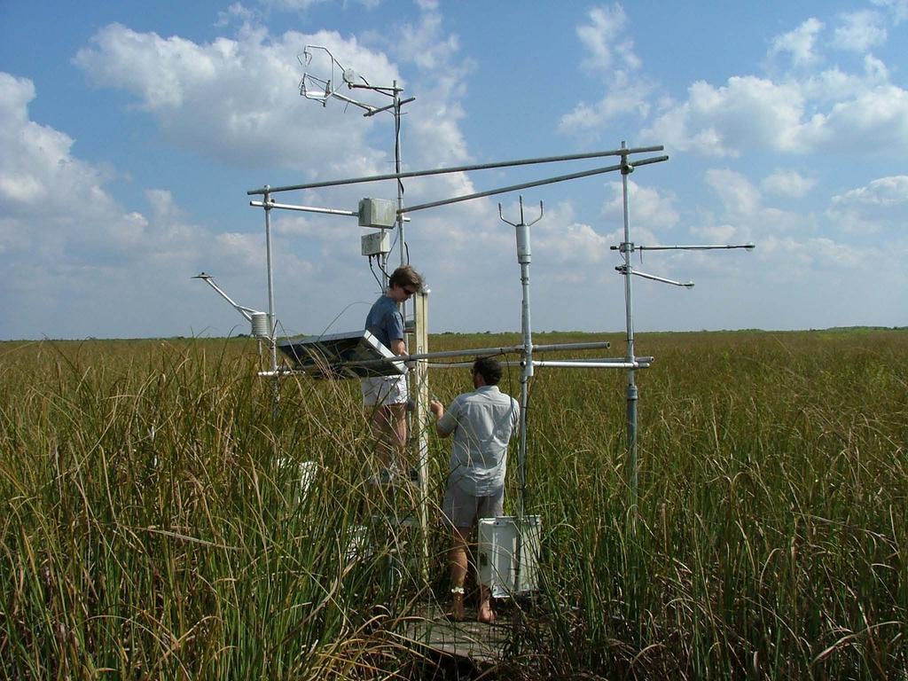
16 28-day ALEXI composite APRIL Climatological deviation in f PET Palmer Drought Index Drought Moist


17 Project Objectives Validation Target multiple biomes and climates Ameriflux and EOS validation sites Algorithm Enhancement Improve spatial and temporal coverage Thermal sharpening and daily extrapolation Case Study Application Identify stress detection capabilities Florida Everglades
18 ALEXI validation sites ALEXI LATENT HEAT FLUX June 2003 Fort Peck SMEX02/05 Bondville Sevilleta SMEX04 SGP97 Walker Branch Goodwin Creek Audubon Gainesville Everglades

19 SMEX02 flux measurements SOIL MOISTURE EXPERIMENT 2002 (SMEX02) WALNUT CREEK WATERSHED, IA WATERSHED Flux towers 10 km Twin Otter transects


20 Courtesy of J.-L. Roujean MODIS-based vegetation clumping index June 2004 LAI f cover CI nadir QC
21 (Dis)ALEXI vs. tower fluxes ALEXI (watershed average) DisALEXI (tower footprint) ALEXI flux (Wm -2 ) RN λe H G DisALEXI flux (W m -2 ) Avg. tower flux (Wm -2 ) Tower flux (W m -2 )

")
22 Landsat-7 thermal/shortwave imagery Idabel, OK TRAD (60-m) NDVI (30-m)

23 Thermal sharpening Idabel, OK Unsharpened Sharpened 250 m 1 km Kustas et al. 2003, RSE, 85,


24 Latent heat with thermal sharpening STIGLER MARENA NORMAN Unsharpened Sharpened
25 Daily extrapolation Evaporative fraction LAI Terra (~1030 LST) Modeled EF Observed EF Aqua (~1330 LST) Terra only (constant EF) DOY 180 DOY 182 EF = λe RN-G 0.8 ER01 ER09 ER ER DOY Time (CST)


26 Big Cypress National Preserve Landsat 2/13/02


27 Big Cypress National Preserve Blue Cypress Lake USGS flux site


28 Big Cypress National Preserve Broward County USGS flux site
29
30

31 JEANNE CHARLEY 2004 Hurricanes FRANCES Big Cypress National Preserve
32 IRT data at USGS stations Blue Cypress Temperature (C) Broward Co. DRY CHARLEY FRANCES JEANNE Temperature (C) substrate sawgrass Day of year
33 High-resolution thermal is a valuable asset mcanders@wisc.edu NASA LCLUC Science Team Meeting January 2005

34 Sharpened ASTER thermal imagery 90 m 15 m

35 Sharpened ASTER thermal imagery 90 m 15 m
 λe s λe s (W m -2")
36 23 June 1 July ALEXI (5 km) λe c λe s λe c λe s λe c λe c DisALEXI (60m) λe s λe s (W m -2 )
Mapping Evapotranspiration and Drought at Local to Continental Scales Using Thermal Remote Sensing
 Mapping Evapotranspiration and Drought at Local to Continental Scales Using Thermal Remote Sensing M.C. Anderson, W.P. Kustas USDA-ARS, Hydrology and Remote Sensing Laboratory J.M Norman University of
John R. Mecikalski #1, Martha C. Anderson*, Ryan D. Torn #, John M. Norman*, George R. Diak #
 P4.22 THE ATMOSPHERE-LAND EXCHANGE INVERSE (ALEXI) MODEL: REGIONAL- SCALE FLUX VALIDATIONS, CLIMATOLOGIES AND AVAILABLE SOIL WATER DERIVED FROM REMOTE SENSING INPUTS John R. Mecikalski #1, Martha C. Anderson*,
METRIC tm. Mapping Evapotranspiration at high Resolution with Internalized Calibration. Shifa Dinesh
 METRIC tm Mapping Evapotranspiration at high Resolution with Internalized Calibration Shifa Dinesh Outline Introduction Background of METRIC tm Surface Energy Balance Image Processing Estimation of Energy
Evaporative Fraction and Bulk Transfer Coefficients Estimate through Radiometric Surface Temperature Assimilation
 Evaporative Fraction and Bulk Transfer Coefficients Estimate through Radiometric Surface Temperature Assimilation Francesca Sini, Giorgio Boni CIMA Centro di ricerca Interuniversitario in Monitoraggio
6.3 ESTIMATING THE LAND-SURFACE RADIANT, TURBULENT AND CONDUCTIVE ENERGY BUDGETS USING SATELLITE SYSTEMS AND COMPLEMENTARY SYNOPTIC DATA
 6.3 ESTIMATING THE LAND-SURFACE RADIANT, TURBULENT AND CONDUCTIVE ENERGY BUDGETS USING SATELLITE SYSTEMS AND COMPLEMENTARY SYNOPTIC DATA George R. Diak *1,John R. Mecikalski 1, Martha C. Anderson 1, John
USGS Water Census Guidelines and Specifications for ET Remote Sensing
 USGS Water Census Guidelines and Specifications for ET Remote Sensing U.S. Department of the Interior U.S. Geological Survey Guidelines and specifications Many prior and ongoing crop ET remote sensing
Estimation of Wavelet Based Spatially Enhanced Evapotranspiration Using Energy Balance Approach
 Estimation of Wavelet Based Spatially Enhanced Evapotranspiration Using Energy Balance Approach Dr.Gowri 1 Dr.Thirumalaivasan 2 1 Associate Professor, Jerusalem College of Engineering, Department of Civil
The Two Source Energy Balance model using satellite, airborne and proximal remote sensing
 The using satellite, airborne and proximal remote sensing 7 years in a relationship Héctor Nieto Hector.nieto@irta.cat Resistance Energy Balance Models (REBM) E R e n H G Physics based on an analogy to
JOURNAL OF GEOPHYSICAL RESEARCH, VOL. 112, D10117, doi: /2006jd007506, 2007
 Click Here for Full Article JOURNAL OF GEOPHYSICAL RESEARCH, VOL. 112,, doi:10.1029/2006jd007506, 2007 A climatological study of evapotranspiration and moisture stress across the continental United States
Remote sensing estimates of actual evapotranspiration in an irrigation district
 Engineers Australia 29th Hydrology and Water Resources Symposium 21 23 February 2005, Canberra Remote sensing estimates of actual evapotranspiration in an irrigation district Cressida L. Department of
The Delaware Environmental Monitoring & Analysis Center
 The Delaware Environmental Monitoring & Analysis Center Tina Callahan Delaware Estuary Science & Environmental Summit 2013 January 27-30, 2013 What is DEMAC? Delaware Environmental Monitoring & Analysis
Characterizing the multi scale spatial structure of remotely sensed evapotranspiration with information theory
 doi:10.5194/bg-8-2269-2011 Author(s) 2011. CC Attribution 3.0 License. Biogeosciences Characterizing the multi scale spatial structure of remotely sensed evapotranspiration with information theory N. A.
Development of the Canadian Precipitation Analysis (CaPA) and the Canadian Land Data Assimilation System (CaLDAS)
 and the Canadian Land Data Assimilation System (CaLDAS)") Development of the Canadian Precipitation Analysis (CaPA) and the Canadian Land Data Assimilation System (CaLDAS) Marco L. Carrera, Vincent Fortin and Stéphane Bélair Meteorological Research Division Environment
Development of the Canadian Precipitation Analysis (CaPA) and the Canadian Land Data Assimilation System (CaLDAS) Marco L. Carrera, Vincent Fortin and Stéphane Bélair Meteorological Research Division Environment
Flux Tower Data Quality Analysis in the North American Monsoon Region
 Flux Tower Data Quality Analysis in the North American Monsoon Region 1. Motivation The area of focus in this study is mainly Arizona, due to data richness and availability. Monsoon rains in Arizona usually
Seasonal and interannual relations between precipitation, soil moisture and vegetation in the North American monsoon region
 Seasonal and interannual relations between precipitation, soil moisture and vegetation in the North American monsoon region Luis A. Mendez-Barroso 1, Enrique R. Vivoni 1, Christopher J. Watts 2 and Julio
Land Data Assimilation at NCEP NLDAS Project Overview, ECMWF HEPEX 2004
 Dag.Lohmann@noaa.gov, Land Data Assimilation at NCEP NLDAS Project Overview, ECMWF HEPEX 2004 Land Data Assimilation at NCEP: Strategic Lessons Learned from the North American Land Data Assimilation System
Regional offline land surface simulations over eastern Canada using CLASS. Diana Verseghy Climate Research Division Environment Canada
 Regional offline land surface simulations over eastern Canada using CLASS Diana Verseghy Climate Research Division Environment Canada The Canadian Land Surface Scheme (CLASS) Originally developed for the
IHOP Surface Data Workshop Discussion Summary
 IHOP Surface Data Workshop Discussion Summary SYNOPTIC DATA (for model input) Radiosonde data want available at highest vertical resolution possible and at the usual 5-mb interval (JOSS will produce 5-mb
Analyzing Long-Term Drought Effects on Land Surface Temperature and Vegetation Using National Oceanic Atmospheric Administration Satellite s Data
 Analyzing Long-Term Drought Effects on Land Surface Temperature and Vegetation Using National Oceanic Atmospheric Administration Satellite s Data Cornelius Holmes, Derek Morris Jr. S Abstract Analyzing
NIDIS Remote Sensing Workshop: Showcase of Products & Technologies
 Feature Article From Intermountain West Climate Summary, April 2008 NIDIS Remote Sensing Workshop: Showcase of Products & Technologies By Christina Alvord of WWA Three knowledge assessment workshops are
Net Surface Shortwave Radiation from GOES Imagery Product Evaluation Using Ground-Based Measurements from SURFRAD
 Remote Sens. 2015, 7, 10788-10814; doi:10.3390/rs70810788 Article OPEN ACCESS remote sensing ISSN 2072-4292 www.mdpi.com/journal/remotesensing Net Surface Shortwave Radiation from GOES Imagery Product
Introduction to Satellite Derived Vegetation Indices
 Introduction to the Use of Geospatial Information Technology for Drought Risk Management 13-17 November, 2017 Tonle Bassac II Restaurant, Phnom Penh, Cambodia Introduction to Satellite Derived Vegetation
Near Real-time Evapotranspiration Estimation Using Remote Sensing Data
 Near Real-time Evapotranspiration Estimation Using Remote Sensing Data by Qiuhong Tang 08 Aug 2007 Land surface hydrology group of UW Land Surface Hydrology Research Group ❶ ❷ ❸ ❹ Outline Introduction
Thermal-Based Evaporative Stress Index for Monitoring Surface Moisture Depletion
 University of Nebraska - Lincoln DigitalCommons@University of Nebraska - Lincoln Drought Mitigation Center Faculty Publications Drought -- National Drought Mitigation Center 2012 Thermal-Based Evaporative
Sources of Imagery and GIS Data Layers (Last updated October 2005)
") Sources of Imagery and GIS Data Layers (Last updated October 2005) The question of where to find data is one often asked by beginners in precision agriculture and other geospatial projects. The following
Sources of Imagery and GIS Data Layers (Last updated October 2005) The question of where to find data is one often asked by beginners in precision agriculture and other geospatial projects. The following
Flash Droughts: Their Characteristics and A Proposed Definition
 Flash Droughts: Their Characteristics and A Proposed Definition Jason Otkin University of Wisconsin-Madison, Cooperative Institute for Meteorological Satellite Studies Jeff Basara and Jordan Christian
Enhancement of the U.S. Drought Monitor Through the Integration of NASA Vegetation Index Imagery
 Enhancement of the U.S. Drought Monitor Through the Integration of NASA Vegetation Index Imagery Project and Related Activities at USGS/EROS Jim Verdin, Jesslyn Brown, Yingxin Gu, Gail Schmidt, Troy McVay
Weather and climate outlooks for crop estimates
 Weather and climate outlooks for crop estimates CELC meeting 2016-04-21 ARC ISCW Observed weather data Modeled weather data Short-range forecasts Seasonal forecasts Climate change scenario data Introduction
High-resolution simulations of the Urban Heat Island
 24 October 2013 High-resolution simulations of the Urban Heat Island Andrew Monaghan, Michael Barlage, Leiqiu Hu, Nathan Brunsell, Johannes Feddema, Keith Oleson, Olga Wilhelmi and Steve Sain 1 (Oleson
SMEX04 Bulk Density and Rock Fraction Data: Arizona
 Notice to Data Users: The documentation for this data set was provided solely by the Principal Investigator(s) and was not further developed, thoroughly reviewed, or edited by NSIDC. Thus, support for
Droughts are normal recurring climatic phenomena that vary in space, time, and intensity. They may affect people and agriculture at local scales for
 I. INTRODUCTION 1.1. Background Droughts are normal recurring climatic phenomena that vary in space, time, and intensity. They may affect people and agriculture at local scales for short periods or cover
Remotely sensed land-surface energy fluxes at sub-field scale in heterogeneous agricultural landscape and coniferous plantation
 Biogeosciences, 11, 521 546, 214 www.biogeosciences.net/11/521/214/ doi:1.5194/bg-11-521-214 Author(s) 214. CC Attribution 3. License. Remotely sensed land-surface energy fluxes at sub-field scale in heterogeneous
Towards a Better Monitoring of Soil Moisture Using a Combination of Estimates from Passive of Microwave and Infrared Observations
 City University of New York (CUNY) CUNY Academic Works Master's Theses City College of New York 2011 Towards a Better Monitoring of Soil Moisture Using a Combination of Estimates from Passive of Microwave
Climate Change and Vegetation Phenology
 Climate Change and Vegetation Phenology Climate Change In the Northeastern US mean annual temperature increased 0.7 C over 30 years (0.26 C per decade) Expected another 2-6 C over next century (Ollinger,
Estimation of evapotranspiration using satellite TOA radiances Jian Peng
 Estimation of evapotranspiration using satellite TOA radiances Jian Peng Max Planck Institute for Meteorology Hamburg, Germany Satellite top of atmosphere radiances Slide: 2 / 31 Surface temperature/vegetation
USGS/EROS Accomplishments and Year 3 Plans. Enhancement of the U.S. Drought Monit Through the Integration of NASA Vegetation Index Imagery
 USGS/EROS Accomplishments and Year 3 Plans Enhancement of the U.S. Drought Monit Through the Integration of NASA Vegetation Index Imagery Jesslyn Brown Team Meeting, Austin, TX, 10/6/09 U.S. Department
Evaluation of a MODIS Triangle-based Algorithm for Improving ET Estimates in the Northern Sierra Nevada Mountain Range
 Evaluation of a MODIS Triangle-based Algorithm for Improving ET Estimates in the Northern Sierra Nevada Mountain Range Kyle R. Knipper 1, Alicia M. Kinoshita 2, and Terri S. Hogue 1 January 5 th, 2015
Great Lakes Information Network GIS (Queryable by topic, geography, organization, and upload date 73 layers as of October, 2009)
") Google Earth Files for the Great Lakes and Beyond GLOS Mapping Workshop Alpena, Michigan November 9, 2009 David Hart GIS Specialist University of Wisconsin Sea Grant Institute GREAT LAKES Great Lakes Information
Google Earth Files for the Great Lakes and Beyond GLOS Mapping Workshop Alpena, Michigan November 9, 2009 David Hart GIS Specialist University of Wisconsin Sea Grant Institute GREAT LAKES Great Lakes Information
2009 Progress Report To The National Aeronautics and Space Administration NASA Energy and Water Cycle Study (NEWS) Program
 Program") 2009 Progress Report To The National Aeronautics and Space Administration NASA Energy and Water Cycle Study (NEWS) Program Proposal Title: Grant Number: PI: The Challenges of Utilizing Satellite Precipitation
2009 Progress Report To The National Aeronautics and Space Administration NASA Energy and Water Cycle Study (NEWS) Program Proposal Title: Grant Number: PI: The Challenges of Utilizing Satellite Precipitation
Accuracy Issues Associated with Satellite Remote Sensing Soil Moisture Data and Their Assimilation
 Proceedings of the 8th International Symposium on Spatial Accuracy Assessment in Natural Resources and Environmental Sciences Shanghai, P. R. China, June 25-27, 2008, pp. 213-220 Accuracy Issues Associated
Land Surface Temperature Measurements From the Split Window Channels of the NOAA 7 Advanced Very High Resolution Radiometer John C.
 Land Surface Temperature Measurements From the Split Window Channels of the NOAA 7 Advanced Very High Resolution Radiometer John C. Price Published in the Journal of Geophysical Research, 1984 Presented
METEOSAT SECOND GENERATION DATA FOR ASSESSMENT OF SURFACE MOISTURE STATUS
 METEOSAT SECOND GENERATION DATA FOR ASSESSMENT OF SURFACE MOISTURE STATUS Simon Stisen (1), Inge Sandholt (1), Rasmus Fensholt (1) (1) Institute of Geography, University of Copenhagen, Oestervoldgade 10,
Global es)mates of evapotranspira)on for climate studies using mul)- sensor remote sensing data: Evalua)on of three process- based
mates of evapotranspira)on for climate studies using mul)- sensor remote sensing data: Evalua)on of three process- based") Global es)mates of evapotranspira)on for climate studies using mul)- sensor remote sensing data: Evalua)on of three process- based approaches Vinukollu, R.K., Wood, E.F., Ferguson, C.R., Fisher, J.B.:
Global es)mates of evapotranspira)on for climate studies using mul)- sensor remote sensing data: Evalua)on of three process- based approaches Vinukollu, R.K., Wood, E.F., Ferguson, C.R., Fisher, J.B.:
Plant Available Water Monitoring with the Oklahoma Mesonet
 Plant Available Water Monitoring with the Oklahoma Mesonet 2013 No Till Oklahoma Conference, Norman, OK, Feb. 19 20, 2013 Tyson Ochsner Plant and Soil Sciences, Oklahoma State University Funding provided
Continuous Quality Monitoring of Copernicus Global Land Albedo products based on SPOT/VGT observations
 Continuous Quality Monitoring of Copernicus Global Land Albedo products based on SPOT/VGT observations (1) (2) (3) Jorge Sánchez (1) Fernando Camacho (1) Roselyne Lacaze (2) Bruno Smets (3) Introduction:
Monitoring daily evapotranspiration in the Alps exploiting Sentinel-2 and meteorological data
 Monitoring daily evapotranspiration in the Alps exploiting Sentinel-2 and meteorological data M. Castelli, S. Asam, A. Jacob, M. Zebisch, and C. Notarnicola Institute for Earth Observation, Eurac Research,
Interaction of North American Land Data Assimilation System and National Soil Moisture Network: Soil Products and Beyond
 Interaction of North American Land Data Assimilation System and National Soil Moisture Network: Soil Products and Beyond Youlong Xia 1,2, Michael B. Ek 1, Yihua Wu 1,2, Christa Peters-Lidard 3, David M.
AQRP Project Use of Satellite Data to Improve Specifications of Land Surface Parameters
 AQRP Project 14-022 Use of Satellite Data to Improve Specifications of Land Surface Parameters By Richard T. McNider, Kevin Doty and Yu Ling Wu, ESSC University of Alabama Huntsville And Pius Lee NOAA
Impact of NASA EOS data on the scientific literature: 16 years of published research results from Terra, Aqua, Aura, and Aquarius
 Impact of NASA EOS data on the scientific literature: 16 years of published research results from Terra, Aqua, Aura, and Aquarius Gene R. Major NASA Goddard Library Nebulous Connections April 4, 2017 RESACs/RA
Influence of Clouds and Aerosols on the Earth s Radiation Budget Using Clouds and the Earth s Radiant Energy System (CERES) Measurements
 Measurements") Influence of Clouds and Aerosols on the Earth s Radiation Budget Using Clouds and the Earth s Radiant Energy System (CERES) Measurements Norman G. Loeb Hampton University/NASA Langley Research Center Bruce
Influence of Clouds and Aerosols on the Earth s Radiation Budget Using Clouds and the Earth s Radiant Energy System (CERES) Measurements Norman G. Loeb Hampton University/NASA Langley Research Center Bruce
Satellite Activities and Products for Hydrological Applications: NOAA & CEOS
 GEO UNESCO Workshop: AfWCCI Demo Project Session Satellite Activities and Products for Hydrological Applications: NOAA & CEOS Jacob Sutherlun National Oceanic and Atmospheric Administration Vice-Chair
GMES: calibration of remote sensing datasets
 GMES: calibration of remote sensing datasets Jeremy Morley Dept. Geomatic Engineering jmorley@ge.ucl.ac.uk December 2006 Outline Role of calibration & validation in remote sensing Types of calibration
GEOG Lecture 8. Orbits, scale and trade-offs
 Environmental Remote Sensing GEOG 2021 Lecture 8 Orbits, scale and trade-offs Orbits revisit Orbits geostationary (36 000 km altitude) polar orbiting (200-1000 km altitude) Orbits revisit Orbits geostationary
A methodology for estimation of surface evapotranspiration
 1 A methodology for estimation of surface evapotranspiration over large areas using remote sensing observations Le Jiang and Shafiqul Islam Cincinnati Earth Systems Science Program, Department of Civil
Greening of Arctic: Knowledge and Uncertainties
 Greening of Arctic: Knowledge and Uncertainties Jiong Jia, Hesong Wang Chinese Academy of Science jiong@tea.ac.cn Howie Epstein Skip Walker Moscow, January 28, 2008 Global Warming and Its Impact IMPACTS
A Facility for Producing Consistent Remotely Sensed Biophysical Data Products of Australia
 TERRESTRIAL ECOSYSTEM RESEARCH NETWORK - AusCover - A Facility for Producing Consistent Remotely Sensed Biophysical Data Products of Australia June, 2011 Mervyn Lynch Professor of Remote Sensing Curtin
Interannual variation of MODIS NDVI in Lake Taihu and its relation to climate in submerged macrophyte region
 Yale-NUIST Center on Atmospheric Environment Interannual variation of MODIS NDVI in Lake Taihu and its relation to climate in submerged macrophyte region ZhangZhen 2015.07.10 1 Outline Introduction Data
Satellite-based Lake Surface Temperature (LST) Homa Kheyrollah Pour Claude Duguay
 Homa Kheyrollah Pour Claude Duguay") Satellite-based Lake Surface Temperature (LST) Homa Kheyrollah Pour Claude Duguay Lakes in NWP models Interaction of the atmosphere and underlying layer is the most important issue in climate modeling
Satellite-based Lake Surface Temperature (LST) Homa Kheyrollah Pour Claude Duguay Lakes in NWP models Interaction of the atmosphere and underlying layer is the most important issue in climate modeling
Manoa Watershed Water Balance Study: Potential ET
 Manoa Watershed Water Balance Study: Potential ET Wyatt Blair, Josh Donovan, Max Irion, Jordan Muratsuchi, and David Heir Geography 405 Fall 2016 Overview Introduction Objectives Methodology Results Summary/Conclusion
Views of the 2016 Northern Plains Flash Drought: Farmer Perspectives and Remote Sensing Data
 Views of the 2016 Northern Plains Flash Drought: Farmer Perspectives and Remote Sensing Data PRESENTATION BY TONY MUCIA RESEARCH CONDUCTED BY JASON OTKIN, TONYA HAIGHT, AND TONY MUCIA Project Overview
MONITORING OF WATER USE, DROUGHT AND YIELD IMPACTS OF WINTER WHEAT USING IMAGINERY FROM SATELLITES
 MONITORING OF WATER USE, DROUGHT AND YIELD IMPACTS OF WINTER WHEAT USING IMAGINERY FROM SATELLITES JURECKA FRANTISEK 1,2, ANDERSON MARTHA 3, HLAVINKA PETR 1,2, SEMERADOVA DANIELA 1,2, TRNKA MIROSLAV 1,2,
P4.13 USING MODIS LST TO ESTIMATE MINIMUM AIR TEMPERATURES AT NIGHT
 P4.13 USING MODIS LST TO ESTIMATE MINIMUM AIR TEMPERATURES AT NIGHT Philip Jones 1 *, Gary Jedlovec 2, Ron Suggs 2, and Stephanie Haines 1 1 University of Alabama in Huntsville, Huntsville, AL 2 Global
Assimilating terrestrial remote sensing data into carbon models: Some issues
 University of Oklahoma Oct. 22-24, 2007 Assimilating terrestrial remote sensing data into carbon models: Some issues Shunlin Liang Department of Geography University of Maryland at College Park, USA Sliang@geog.umd.edu,
Results of the ESA-DUE UHI project
 13/12/2011 Results of the ESA-DUE UHI project Bino Maiheu (bino.maiheu@vito.be), on behalf of the UHI project Outline» Urban heat island problem» The ESA-DUE urban heat island project» UHI air temperature
Remote Sensing Applications for Drought Monitoring
 Remote Sensing Applications for Drought Monitoring Amir AghaKouchak Center for Hydrometeorology and Remote Sensing Department of Civil and Environmental Engineering University of California, Irvine Outline
Flux Tower Data Quality Analysis. Dea Doklestic
 Flux Tower Data Quality Analysis Dea Doklestic Motivation North American Monsoon (NAM) Seasonal large scale reversal of atmospheric circulation Occurs during the summer months due to a large temperature
Methane Sensing Flight of Scanning HIS over Hutchinson, KS, 31 March 2001
 Methane Sensing Flight of Scanning HIS over Hutchinson, KS, 31 March 2001 Hank Revercomb, Chris Moeller, Bob Knuteson, Dave Tobin, Ben Howell University of Wisconsin, Space Science and Engineering Center
USE OF SATELLITE REMOTE SENSING IN HYDROLOGICAL PREDICTIONS IN UNGAGED BASINS
 USE OF SATELLITE REMOTE SENSING IN HYDROLOGICAL PREDICTIONS IN UNGAGED BASINS Venkat Lakshmi, PhD, P.E. Department of Geological Sciences, University of South Carolina, Columbia SC 29208 (803)-777-3552;
Customizable Drought Climate Service for supporting different end users needs
 1 Customizable Drought Climate Service for supporting different end users needs Ramona MAGNO, T. De Filippis, E. Di Giuseppe, M. Pasqui, E. Rapisardi, L. Rocchi (IBIMET-CNR; LaMMA Consortium) 1 Congresso
Recent Update on MODIS C6 and VIIRS Deep Blue Aerosol Products
 Recent Update on MODIS C6 and VIIRS Deep Blue Aerosol Products N. Christina Hsu, Photo taken from Space Shuttle: Fierce dust front over Libya Corey Bettenhausen, Andrew M. Sayer, and Rick Hansell Laboratory
Assimilation of ASCAT soil wetness
 EWGLAM, October 2010 Assimilation of ASCAT soil wetness Bruce Macpherson, on behalf of Imtiaz Dharssi, Keir Bovis and Clive Jones Contents This presentation covers the following areas ASCAT soil wetness
Weather Outlook: 2015 Growing Season
 Weather Outlook: 2015 Growing Season Leon F. Osborne Chester Fritz Distinguished Professor Regional Weather Information Center University of North Dakota Grand Forks, North Dakota Why Should We Be Concerned?
Interpretation of Polar-orbiting Satellite Observations. Atmospheric Instrumentation
 Interpretation of Polar-orbiting Satellite Observations Outline Polar-Orbiting Observations: Review of Polar-Orbiting Satellite Systems Overview of Currently Active Satellites / Sensors Overview of Sensor
Eric. W. Harmsen 1, John Mecikalski 2, Pedro Tosado Cruz 1 Ariel Mercado Vargas 1
 Estimating Evapotranspiration using Satellite Remote Sensing in Puerto Rico, Haiti and the Dominican Republic Eric. W. Harmsen 1, John Mecikalski 2, Pedro Tosado Cruz 1 Ariel Mercado Vargas 1 1. University
Applications of yield monitoring systems and agricultural statistics in agricultural (re)insurance
insurance") Image: used under license from shutterstock.com Applications of yield monitoring systems and agricultural statistics in agricultural (re)insurance 18 October 2018 Ernst Bedacht Agenda Introduction 1. Munich
Image: used under license from shutterstock.com Applications of yield monitoring systems and agricultural statistics in agricultural (re)insurance 18 October 2018 Ernst Bedacht Agenda Introduction 1. Munich
Aquarius/SAC-D Soil Moisture Product using V3.0 Observations
 Aquarius/SAC-D Soil Moisture Product using V3. Observations R. Bindlish, T. Jackson, M. Cosh November 214 Overview Soil moisture algorithm Soil moisture product Validation Linkage between Soil Moisture
Assessing Drought in Agricultural Area of central U.S. with the MODIS sensor
 Assessing Drought in Agricultural Area of central U.S. with the MODIS sensor Di Wu George Mason University Oct 17 th, 2012 Introduction: Drought is one of the major natural hazards which has devastating
Cross-Sensor Continuity Science Algorithm
 Cross-Sensor Continuity Science Algorithm - Long Term Vegetation Index and Phenology Workshop - Javzan Tsend-Ayush and Tomoaki Miura Department of Natural Resources and Environmental Management University
Regional Drought Decision Support System (RDDSS) Project Update and Product Concepts
 Project Update and Product Concepts") Regional Drought Decision Support System (RDDSS) Project Update and Product Concepts Part of the Red River Basin Decision Information Network (RRBDIN) NEXT-GEN RRBDIN Decision Support for the Red River
Regional Drought Decision Support System (RDDSS) Project Update and Product Concepts Part of the Red River Basin Decision Information Network (RRBDIN) NEXT-GEN RRBDIN Decision Support for the Red River
An Algorithm for Retrieving Land Surface Temperatures Using VIIRS Data in Combination with Multi-Sensors
 Sensors 2014, 14, 21385-21408; doi:10.3390/s141121385 Article OPEN ACCESS sensors ISSN 1424-8220 www.mdpi.com/journal/sensors An Algorithm for Retrieving Land Surface Temperatures Using VIIRS Data in Combination
Length Scale Analysis of Surface Energy Fluxes Derived from Remote Sensing
 1212 JOURNAL OF HYDROMETEOROLOGY VOLUME 4 Length Scale Analysis of Surface Energy Fluxes Derived from Remote Sensing NATHANIEL A. BRUNSELL* Department of Plants, Soils, and Biometeorology, Utah State University,
Analyzing and Visualizing Precipitation and Soil Moisture in ArcGIS
 Analyzing and Visualizing Precipitation and Soil Moisture in ArcGIS Wenli Yang, Pham Long, Peisheng Zhao, Steve Kempler, and Jennifer Wei * NASA Goddard Earth Science Data and Information Services Center
Evapotranspiration. Andy Black. CCRN Processes Workshop, Hamilton, ON, Sept Importance of evapotranspiration (E)
") Evapotranspiration Andy Black CCRN Processes Workshop, Hamilton, ON, 12-13 Sept 213 Importance of evapotranspiration (E) This process is important in CCRN goals because 1. Major component of both terrestrial
Evapotranspiration Andy Black CCRN Processes Workshop, Hamilton, ON, 12-13 Sept 213 Importance of evapotranspiration (E) This process is important in CCRN goals because 1. Major component of both terrestrial
Amita Mehta and Ana Prados
 Building Capacity in Utilizing NASA Remote Sensing Observations in SWAT for Water Resources and Agricultural Management Applications Amita Mehta and Ana Prados NASA - University of Maryland Baltimore County
1.11 CROSS-VALIDATION OF SOIL MOISTURE DATA FROM AMSR-E USING FIELD OBSERVATIONS AND NASA S LAND DATA ASSIMILATION SYSTEM SIMULATIONS
 1.11 CROSS-VALIDATION OF SOIL MOISTURE DATA FROM AMSR-E USING FIELD OBSERVATIONS AND NASA S LAND DATA ASSIMILATION SYSTEM SIMULATIONS Alok K. Sahoo *, Xiwu Zhan** +, Kristi Arsenault** and Menas Kafatos
Some NOAA Products that Address PSTG Satellite Observing Requirements. Jeff Key NOAA/NESDIS Madison, Wisconsin USA
 Some NOAA Products that Address PSTG Satellite Observing Requirements Jeff Key NOAA/NESDIS Madison, Wisconsin USA WMO Polar Space Task Group, 4 th meeting, Greenbelt, 30 September 2014 Relevant Missions
Evaluation of Drought Indices Based on Thermal Remote Sensing of Evapotranspiration over the Continental United States
 University of Nebraska - Lincoln DigitalCommons@University of Nebraska - Lincoln Drought Mitigation Center Faculty Publications Drought -- National Drought Mitigation Center 4-15-2011 Evaluation of Drought
Radiation balance of the Earth. 6. Earth radiation balance under present day conditions. Top of Atmosphere (TOA) Radiation balance
 Radiation balance") Radiation balance of the Earth Top of Atmosphere (TOA) radiation balance 6. Earth radiation balance under present day conditions Atmospheric radiation balance: Difference between TOA and surface radiation
Radiation balance of the Earth Top of Atmosphere (TOA) radiation balance 6. Earth radiation balance under present day conditions Atmospheric radiation balance: Difference between TOA and surface radiation
Implementation of Coupled Skin Temperature. Atmospheric Data Assimilation System. Jon D. Radakovich, Michael G. Bosilovich,
 Implementation of Coupled Skin Temperature Implementation Analysis and of Bias Coupled Correction Skin Temperature in a Global Analysis Atmospheric and Bias Data Correction Assimilation in a System Global
THE RAINWATER HARVESTING SYMPOSIUM 2015
 THE RAINWATER HARVESTING SYMPOSIUM 2015 Remote Sensing for Rainwater Harvesting and Recharge Estimation under Data Scarce Conditions Taye Alemayehu Ethiopian Institute of Water Resources, Metameta Research
Climate Prediction Center National Centers for Environmental Prediction
 NOAA s Climate Prediction Center Climate Monitoring Tool Wassila M. Thiaw and CPC International Team Climate Prediction Center National Centers for Environmental Prediction CPC International Team Vadlamani
Indian National (Weather) SATellites for Agrometeorological Applications
 SATellites for Agrometeorological Applications") Indian National (Weather) SATellites for Agrometeorological Applications Bimal K. Bhattacharya Agriculture-Terrestrial Biosphere- Hydrology Group Space Applications Centre (ISRO) Ahmedabad 380015, India
Indian National (Weather) SATellites for Agrometeorological Applications Bimal K. Bhattacharya Agriculture-Terrestrial Biosphere- Hydrology Group Space Applications Centre (ISRO) Ahmedabad 380015, India
Remote Sensing Applications for Land/Atmosphere: Earth Radiation Balance
 Remote Sensing Applications for Land/Atmosphere: Earth Radiation Balance - Introduction - Deriving surface energy balance fluxes from net radiation measurements - Estimation of surface net radiation from
SOIL MOISTURE MAPPING THE SOUTHERN U.S. WITH THE TRMM MICROWAVE IMAGER: PATHFINDER STUDY
 SOIL MOISTURE MAPPING THE SOUTHERN U.S. WITH THE TRMM MICROWAVE IMAGER: PATHFINDER STUDY Thomas J. Jackson * USDA Agricultural Research Service, Beltsville, Maryland Rajat Bindlish SSAI, Lanham, Maryland
GLOBAL LAND DATA ASSIMILATION SYSTEM (GLDAS) PRODUCTS FROM NASA HYDROLOGY DATA AND INFORMATION SERVICES CENTER (HDISC) INTRODUCTION
 PRODUCTS FROM NASA HYDROLOGY DATA AND INFORMATION SERVICES CENTER (HDISC) INTRODUCTION") GLOBAL LAND DATA ASSIMILATION SYSTEM (GLDAS) PRODUCTS FROM NASA HYDROLOGY DATA AND INFORMATION SERVICES CENTER (HDISC) Hongliang Fang, Patricia L. Hrubiak, Hiroko Kato, Matthew Rodell, William L. Teng,
GLOBAL LAND DATA ASSIMILATION SYSTEM (GLDAS) PRODUCTS FROM NASA HYDROLOGY DATA AND INFORMATION SERVICES CENTER (HDISC) Hongliang Fang, Patricia L. Hrubiak, Hiroko Kato, Matthew Rodell, William L. Teng,
The Influence of Historical and Projected Land Use and Land Cover Changes on Land Surface Hydrology and Regional Weather and Climate Variability
 The Influence of Historical and Projected Land Use and Land Cover Changes on Land Surface Hydrology and Regional Weather and Climate Variability Research Hypothesis: Land use and land cover changes are
Spati-temporal Changes of NDVI and Their Relations with Precipitation and Temperature in Yangtze River Catchment from 1992 to 2001
 Spati-temporal Changes of NDVI and Their Relations with Precipitation and Temperature in Yangtze River Catchment from 1992 to 2001 ZHANG Li 1, CHEN Xiao-Ling 1, 2 1State Key Laboratory of Information Engineering
The use of satellite images to forecast agricultural production
 The use of satellite images to forecast agricultural production Artur Łączyński Central Statistical Office, Agriculture Department Niepodległości 208 Warsaw, Poland E-mail a.laczynski@stat.gov.pl DOI:
Comparison of Land Surface Infrared Spectral Emissivity Derived from MetOp IASI and Aqua AIRS
 Comparison of Land Surface Infrared Spectral Emissivity Derived from MetOp IASI and Aqua AIRS Robert Knuteson, Eva Borbas, Szu Chia Moeller, Henry Revercomb, Suzanne Seeman, and David Tobin CIMSS/SSEC,
Atmospheric Sciences 321. Science of Climate. Lecture 14: Surface Energy Balance Chapter 4
 Atmospheric Sciences 321 Science of Climate Lecture 14: Surface Energy Balance Chapter 4 Community Business Check the assignments HW #4 due Today, HW#5 is posted Quiz Today on Chapter 3, too. Mid Term