Interaction of North American Land Data Assimilation System and National Soil Moisture Network: Soil Products and Beyond
|
|
|
- Susan Rice
- 6 years ago
- Views:
Transcription


1 Interaction of North American Land Data Assimilation System and National Soil Moisture Network: Soil Products and Beyond Youlong Xia 1,2, Michael B. Ek 1, Yihua Wu 1,2, Christa Peters-Lidard 3, David M. Mocko 4,5, and Sujay V. Kumar 4 1 Environmental Modeling Center (EMC), National Centers for Environmental Prediction (NCEP), National Oceanic and Atmospheric Administration (NOAA), College Park, Maryland 2 I.M. Systems Group at NCEP/EMC, College Park, Maryland 3 Hydrosphere, Biosphere, and Geophysics in the Earth Sciences Division, Goddard Space Flight Center (GSFC), National Aeronautics and Space Administration (NASA), Greenbelt, Maryland 4 Hydrological Sciences Laboratory (HSL), Goddard Space Flight Center (GSFC), National Aeronautics and Space Administration (NASA), Greenbelt, Maryland 5 SAIC at NASA/GSFC, Greenbelt, Maryland

2 Current Operational NLDAS Land Surface Models: NCEP/Noah, NASA/Mosaic, NWC/SAC, and Princeton/Washington/VIC NLDAS Products: water fluxes precipitation, runoff, routed streamflow, snowmelt, sublimation, ET; energy fluxes downward/upward shortwave and longwave radiation, net radiation, sensible heat flux, latent heat flux, ground heat flux; NLDAS is a multi-model land modeling and data assimilation system run in uncoupled mode driven by atmospheric forcing (using surface meteorology data sets) with long-term retrospective and near real-time output of land-surface water and energy budgets. state variables soil temperature, soil moisture (liquid, frozen, total), skin temperature, SWE, snow cover and fraction, terrestrial water storage. Product evaluation/validation Using in situ observations, remote sensing data, and reanalysis data to compressively evaluate almost all NLDAS products for different spatial and temporal scales. For more details, please see NASA NLDAS website:


3 Next Phase NLDAS System LIS-Based Framework NASA Land Information System (LIS) Framework Assimilation of soil moisture, snowpack, and GRACE terrestrial water storage Models: Catchment, Noah-MP, CLM4.5(??), Noah3.6, VIC4.1.2 Addition of groundwater and dynamic vegetation module Output: groundwater storage, carbon flux, leaf area index and greenness fraction (simulated) Noah-MP3.6 Groundwater


4 NLDAS Website More details can see NCEP and NASA NLDAS website

5 Contributions of NLDAS Product to National Integrated Drought Information System (NIDIS, drought.gov) NLDAS Drought Monitor These products have been widely used by U.S. drought monitor author group, CPC, various regional climate centers and river forecast centers.
6 NLDAS Soil Moisture and Temperature NLDAS Reliability: NCEP operational product with a 4-day lag Resolution: spatial degree (~12-14 km), temporal hourly (daily, monthly, yearly) Vertical Soil Depth: 0-10 cm (5cm at mid-soil layer), cm (25 cm), cm (70 cm), cm (150cm). SAC and VIC use their post-processes to convert simulated soil moisture to Noah soil layers. Only Noah and VIC has four layers soil temperature. Covering Period: 02 January present Next phase NLDAS Update NLDAS2.5 and NLDAS3.0 Achieve Actual Real-time by Closing the 4-day lag (~ 1-2 years) Upgrade Land Surface Models: Noah-2.8 Noah-3.6; Mosaic Catchment Model; VIC VIC-4.1.2; and Noah-MP. All models will include soil temperature output (~1-2 years) Achieve Actual Data Assimilation by using remotely sensed soil moisture, snowpack and GRACE TWS data (~2 years) NLDAS white paper including design, plan and work schedule is nearly ready!

7 NLDAS Noah Soil Temperature Validation J. Appl. Meteorol. Climatol.,52, , US cooperative station and 72 Oklahoma Mesonet stations Errors < 3 o C for most cases monthly mean soil temperature comparison OBS Model OBS Model daily soil temperature

8 NLDAS soil temperature helps control NASMD data J. Appl. Meteorol. Climatol., 54, , 2015 YOULONG XIA, TRENT W. FORD, YIHUA WU, STEVEN M. QUIRING, AND MICHAEL B. EK For partially frozen soil cases
 J.")

9 NLDAS soil moisture evaluation in North American Soil Moisture Database (NASMD) J. Hydrometeor., 16, , 2015 YOULONG XIA, MICHAEL B. EK, YIHUA WU, TRENT W. FORD, AND STEVEN M. QUIRING
10 In model parameterization, the differences due to transpiration formula using liquid or total (liquid + ice) soil moisture. Soil physics plays an important role in particular spring time. Flux Differences (W m -2 ) Soil Temp Differences (K) L-T_TS1 L-T_TS2 L-T_TS3 L-T_TS4 Outputs for Tenderfoot Creek (Lat: 46.95, Lon , Elevation 2255 m) 1-4: four Noah soil layers L-T_GFLX L-T_LHFLX L-T_NLWR L-T_NSWR L-T_SHFLX Month Month SM Differences SM Differences Liquid SM difference L-T_LSL1 L-TSML Month L-T_LSL3 L-TSML Month Total SM L-T_LSL2 L-TSML Month L-T_LSL4 L-TSML Month
 adding actual assimilation process Kumar et al.")

11 Improvement of NLDAS soil moisture via (1) upgrading model physics and (2) adding actual assimilation process Kumar et al., 2016, J. Hydrometeor.,17, CLSM-F2.5 with GRACE DA 5 cm soil moisture evaluation Warm color - significant improvement

12 Energy and Water Fluxes Evaluation in NLDAS Sensible Heat

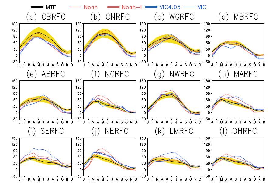
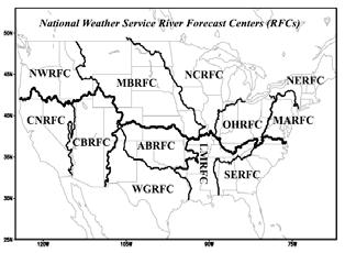
13 NSE Nash-Sutcliffe Efficiency Q- USGS ET- Gridded FUXNET Research version improved Q and ET simulations for most RFCs 12 River Forecast Centers Xia et al, JGR, 2016b
 Operational NLDAS Router (Xia et al.")
 Colorado Front Ridge Flooding in September 2013")


14 Daily streamflow evaluation in NLDAS Nash-Sutcliffe Efficiency (NSE) Operational NLDAS Router (Xia et al., 2021, JGR- Atmos.) Colorado Front Ridge Flooding in September 2013 Mosaic Catchment VIC4.1.2 Noah3.3 Noah3.6 Noah-MP VIC4.1.2 performs best and CLSM-F2.5 performs worst. Larger NSE appears in southeast and west coast where there are large precipitation. Small NSE appears in interior US region as there is less precipitation.

15 Terrestrial Water Storage (TWS) Anomaly Evaluation (TWS=SMC+SWE+GWS), SMC-soil moisture content, SWE snow water equivalent, GWS-ground water storage Xia et al., JHM, 2017
 is ongoing.")
16 SWE Evaluation in LIS-Based NLDAS CLSM-F2.5 has too little SWE when compared with SNODAS SWE. The reason is large sublimation. Further investigation (leading to large sublimation) is ongoing. Xia et al, JHM, 2017


17 Xia et al., JHM, 2017 GWS Evaluation in LIS-Based NLDAS
")


18 2011 Texas Drought (different options for Noah-MP) US Drought Monitor The dynamic vegetation run (upper left) completely misses the 2011 TX drought in the top 1-m soil moisture. The other runs that use WRF default vegetation do a better job, and are similar to each other, despite using groundwater, equilibrium water table, or free drainage.

19 2011 Texas Drought Top 1m Soil Moisture ET Greenness Fraction GWS The top 1-m soil moisture does not decrease in TX during 2011 drought, compared to the other runs. GWS behaves similarly between dynamic vegetation and WRF default, although with slightly different mean values. Evaporation is much lower during the summer due to lower GVF and LAI from the dynamic vegetation run. LAI
20 2011 Texas Drought In-situ soil moisture can help identify which run is correct Different options are being tested and evaluated in NLDAS science testbed These figures now show the 4 soil moisture layers for (LEFT) dynamic vegetation and (RIGHT) WRF default vegetation. The top layer SM is generally similar, but the 2 nd and 3 rd layers differ significantly between the runs. In the dynamic vegetation, there is little drying of the SM, while in the WRF default runs, the soil moisture drops significantly in the late summer.
21 Future work plan To enhance the collaboration with NSMN scientists to use observed soil data to improve NLDAS product quality and model physical processes understanding To efficiently use NASA/NCEP joint NLDAS science and evaluation testbed to help R2O task via O2R experiments To achieve real-time (zero day lag) NLDAS system to meet the public requirements NLDAS2.5 To transition LIS-based NLDAS system developed at NASA to NCEP to move toward operational implementation (R2O) NLDAS3.0 To extend NLDAS to North America and 1/8 th degree to 1~3 km (NLDAS 3.5 and beyond) To unify NLDAS with GLDAS to form a unified LDAS system at NCEP To improve surface forcing, to upgrade soil and vegetation parameter datasets, to add irrigation, vegetation dynamics, groundwater dynamics, lake model, ecosystem processes, biochemistry, carbon and nitrogen dynamics, etc.
22 Useful Datasets from NSMN for NCEP/NASA NLDAS team 1. Several example datasets have liquid and frozen soil moisture measurement separately. This will help our model team to check if model physical processes are correct for frozen soil simulation. 2. More soil moisture measurements in middle to east Texas will help us to check if our models can correctly capture soil moisture variation, such as 2011 Texas drought. 3. Harmonized and QC soil moisture and temperature measurement is helpful for NLDAS product evaluation/validation in future. 4. Human management impacts. There should be focused effort to capture the impact and seasonality from human management processes as part of NSMN (from Sujay Kumar) 5. Biases: Right now, the global soil moisture climatology is unknown. The NSMN should consider as part of its core mission to close this gap by bringing the in-situ, model, remote sensing communities together (from Sujay Kumar). Potential contributions to NSMN from NLDAS Project 1. NLDAS is going to provide spatially and temporally continuous soil moisture estimates from latest models and remote sensing datasets km and high-resolution NLDAS (1-3 km) soil product, snow water equivalent, terrestrial water storage, groundwater, simulated/predicted LAI, greenness fraction, and ET 3. NLDAS soil products with reasonable soil physics explanations 4. Gridded data in national, North America, and global domain
23
Land Data Assimilation at NCEP NLDAS Project Overview, ECMWF HEPEX 2004
 Dag.Lohmann@noaa.gov, Land Data Assimilation at NCEP NLDAS Project Overview, ECMWF HEPEX 2004 Land Data Assimilation at NCEP: Strategic Lessons Learned from the North American Land Data Assimilation System
Multivariate assimilation of satellite-derived remote sensing datasets in the North American Land Data Assimilation System (NLDAS)
") Multivariate assimilation of satellite-derived remote sensing datasets in the North American Land Data Assimilation System (NLDAS) Sujay V. Kumar 1,2, Christa D. Peters-Lidard 1, David Mocko 1,2,3, Rolf
Multivariate assimilation of satellite-derived remote sensing datasets in the North American Land Data Assimilation System (NLDAS) Sujay V. Kumar 1,2, Christa D. Peters-Lidard 1, David Mocko 1,2,3, Rolf
Michael B. Ek 1, Youlong Xia 1,2, Jesse Meng 1,2, and Jiarui Dong 1,2
 Michael B. Ek 1, Youlong Xia 1,2, Jesse Meng 1,2, and Jiarui Dong 1,2 1 Land-Hydrology Team Environmental Modeling Center (EMC) National Centers for Environmental Prediction (NCEP) National Weather Service
Land Analysis in the NOAA CFS Reanalysis. Michael Ek, Ken Mitchell, Jesse Meng Helin Wei, Rongqian Yang, and George Gayno
 Land Analysis in the NOAA CFS Reanalysis Michael Ek, Ken Mitchell, Jesse Meng Helin Wei, Rongqian Yang, and George Gayno 1 Outline CFS Reanalysis execution Land surface model upgrade from OSU to Noah LIS/GLDAS
Implementation of Land Information System in the NCEP Operational Climate Forecast System CFSv2. Jesse Meng, Michael Ek, Rongqian Yang, Helin Wei
 Implementation of Land Information System in the NCEP Operational Climate Forecast System CFSv2 Jesse Meng, Michael Ek, Rongqian Yang, Helin Wei 1 Outline NCEP CFSRR Land component CFSv1 vs CFSv2 Land
Improving Streamflow Prediction in Snow- fed River Basins via Satellite Snow Assimilation
 Improving Streamflow Prediction in Snow- fed River Basins via Satellite Snow Assimilation Yuqiong Liu NASA GSFC & University of Maryland, College Park Co- authors: Christa Peters- Lidard, Sujay Kumar,
GE G Climate Science Lab
 GE G Climate Science Lab North American Soil Moisture Database: Development and Applications Steven M. Quiring Texas A&M University Trenton Ford Texas A&M University http://climatology.tamu.edu http://facebook.com/geogcsl
An Ensemble Land Surface Modeling and Assimilation Testbed for HEPEX
 GSFC s Land Data Assimilation Systems: An Ensemble Land Surface Modeling and Assimilation Testbed for HEPEX Christa Peters-Lidard Lidard,, Paul Houser, Matthew Rodell, Brian Cosgrove NASA Goddard Space
GLOBAL LAND DATA ASSIMILATION SYSTEM (GLDAS) PRODUCTS FROM NASA HYDROLOGY DATA AND INFORMATION SERVICES CENTER (HDISC) INTRODUCTION
 PRODUCTS FROM NASA HYDROLOGY DATA AND INFORMATION SERVICES CENTER (HDISC) INTRODUCTION") GLOBAL LAND DATA ASSIMILATION SYSTEM (GLDAS) PRODUCTS FROM NASA HYDROLOGY DATA AND INFORMATION SERVICES CENTER (HDISC) Hongliang Fang, Patricia L. Hrubiak, Hiroko Kato, Matthew Rodell, William L. Teng,
GLOBAL LAND DATA ASSIMILATION SYSTEM (GLDAS) PRODUCTS FROM NASA HYDROLOGY DATA AND INFORMATION SERVICES CENTER (HDISC) Hongliang Fang, Patricia L. Hrubiak, Hiroko Kato, Matthew Rodell, William L. Teng,
NCEP Land-Surface Modeling
 NCEP Land-Surface Modeling Michael Ek and the EMC Land-Hydrology Team Environmental Modeling Center (EMC) National Centers for Environmental Prediction (NCEP) 5200 Auth Road, Room 207 Suitland, Maryland
NIDIS Intermountain West Regional Drought Early Warning System February 7, 2017
 NIDIS Drought and Water Assessment NIDIS Intermountain West Regional Drought Early Warning System February 7, 2017 Precipitation The images above use daily precipitation statistics from NWS COOP, CoCoRaHS,
Operational Perspectives on Hydrologic Model Data Assimilation
 Operational Perspectives on Hydrologic Model Data Assimilation Rob Hartman Hydrologist in Charge NOAA / National Weather Service California-Nevada River Forecast Center Sacramento, CA USA Outline Operational
Land Surface Processes and Their Impact in Weather Forecasting
 Land Surface Processes and Their Impact in Weather Forecasting Andrea Hahmann NCAR/RAL with thanks to P. Dirmeyer (COLA) and R. Koster (NASA/GSFC) Forecasters Conference Summer 2005 Andrea Hahmann ATEC
Implementation of the NCEP operational GLDAS for the CFS land initialization
 Implementation of the NCEP operational GLDAS for the CFS land initialization Jesse Meng, Mickael Ek, Rongqian Yang NOAA/NCEP/EMC July 2012 1 Improving the Global Land Surface Climatology via improved Global
The Community Noah LSM with Multi-physics Options
 The Community Noah LSM with Multi-physics Options Guo-Yue Niu Collaborators: ZL Yang, KE Mitchell, F Chen, MB Ek, M. Barlage, L. Longuevergne, A Kumar, K Manning, D Niyogi, E Rosero, M Tewari, and Y. Xia
The National Operational Hydrologic Remote Sensing Center Operational Snow Analysis
 The National Operational Hydrologic Remote Sensing Center Operational Snow Analysis World Meteorological Organization Global Cryosphere Watch Snow-Watch Workshop Session 3: Snow Analysis Products Andrew
Dear Editor, Response to Anonymous Referee #1. Comment 1:
 Dear Editor, We would like to thank you and two anonymous referees for the opportunity to revise our manuscript. We found the comments of the two reviewers very useful, which gave us a possibility to address
The Texas drought. Kingtse Mo Climate Prediction Center NWS/NCEP/NOAA
 The 2011-2012 Texas drought Kingtse Mo Climate Prediction Center NWS/NCEP/NOAA 1 outline Evolution of the 2011-2012 Texas drought Climatology and historical perspective The 2011 drought Onset Feedback
Advancing the National Soil Moisture Network
 Advancing the National Soil Moisture Network Steven Quiring (Texas A&M), Jessica Lucido (USGS), & Mike Strobel (USDA NRCS) http://cida.usgs.gov/nsmn_pilot/ Veva Deheza (NIDIS), Roger Pulwarty (NIDIS),
NIDIS Intermountain West Drought Early Warning System October 17, 2017
 NIDIS Drought and Water Assessment NIDIS Intermountain West Drought Early Warning System October 17, 2017 Precipitation The images above use daily precipitation statistics from NWS COOP, CoCoRaHS, and
Developing a High-Resolution Texas Water and Climate Prediction Model
 Developing a High-Resolution Texas Water and Climate Prediction Model Zong-Liang Yang (512) 471-3824 liang@jsg.utexas.edu Water Forum II on Texas Drought and Beyond, Austin, Texas, 22-23 October, 2012
DEVELOPMENT OF A LARGE-SCALE HYDROLOGIC PREDICTION SYSTEM
 JP3.18 DEVELOPMENT OF A LARGE-SCALE HYDROLOGIC PREDICTION SYSTEM Ji Chen and John Roads University of California, San Diego, California ABSTRACT The Scripps ECPC (Experimental Climate Prediction Center)
NIDIS Intermountain West Drought Early Warning System April 18, 2017
 1 of 11 4/18/2017 3:42 PM Precipitation NIDIS Intermountain West Drought Early Warning System April 18, 2017 The images above use daily precipitation statistics from NWS COOP, CoCoRaHS, and CoAgMet stations.
NIDIS Intermountain West Drought Early Warning System September 4, 2018
 NIDIS Drought and Water Assessment NIDIS Intermountain West Drought Early Warning System September 4, 2018 Precipitation The images above use daily precipitation statistics from NWS COOP, CoCoRaHS, and
Water Balance in the Murray-Darling Basin and the recent drought as modelled with WRF
 18 th World IMACS / MODSIM Congress, Cairns, Australia 13-17 July 2009 http://mssanz.org.au/modsim09 Water Balance in the Murray-Darling Basin and the recent drought as modelled with WRF Evans, J.P. Climate
Seasonal-Scale Drought Forecasting in Africa and the Middle East
 Seasonal-Scale Drought Forecasting in Africa and the Middle East Kristi R. Arsenault (SAIC, Inc; NASA/GSFC) Shrad Shukla (UCSB), Christa Peters-Lidard (NASA/GSFC) and Collaborators GEWEX MEETING, MAY 9,
Drought Monitoring with Hydrological Modelling
 st Joint EARS/JRC International Drought Workshop, Ljubljana,.-5. September 009 Drought Monitoring with Hydrological Modelling Stefan Niemeyer IES - Institute for Environment and Sustainability Ispra -
A Near Real Time Drought Monitoring Capability
 A Near Real Time Drought Monitoring Capability Kingtse Mo, Muthuvel Chelliah, Wayne Higgins and The NCEP Drought Monitoring Team Climate Prediction Center NCEP/NWS/NOAA An Experimental Drought Early Warning
Oregon Water Conditions Report May 1, 2017
 Oregon Water Conditions Report May 1, 2017 Mountain snowpack in the higher elevations has continued to increase over the last two weeks. Statewide, most low and mid elevation snow has melted so the basin
2009 Progress Report To The National Aeronautics and Space Administration NASA Energy and Water Cycle Study (NEWS) Program
 Program") 2009 Progress Report To The National Aeronautics and Space Administration NASA Energy and Water Cycle Study (NEWS) Program Proposal Title: Grant Number: PI: The Challenges of Utilizing Satellite Precipitation
2009 Progress Report To The National Aeronautics and Space Administration NASA Energy and Water Cycle Study (NEWS) Program Proposal Title: Grant Number: PI: The Challenges of Utilizing Satellite Precipitation
NIDIS Intermountain West Drought Early Warning System May 23, 2017
 NIDIS Drought and Water Assessment NIDIS Intermountain West Drought Early Warning System May 23, 2017 Precipitation The images above use daily precipitation statistics from NWS COOP, CoCoRaHS, and CoAgMet
NIDIS Intermountain West Drought Early Warning System November 21, 2017
 NIDIS Drought and Water Assessment NIDIS Intermountain West Drought Early Warning System November 21, 2017 Precipitation The images above use daily precipitation statistics from NWS COOP, CoCoRaHS, and
Flood Forecasting Tools for Ungauged Streams in Alberta: Status and Lessons from the Flood of 2013
 Flood Forecasting Tools for Ungauged Streams in Alberta: Status and Lessons from the Flood of 2013 John Pomeroy, Xing Fang, Kevin Shook, Tom Brown Centre for Hydrology, University of Saskatchewan, Saskatoon
Precipitation. Standardized Precipitation Index. NIDIS Intermountain West Regional Drought Early Warning System January 3, 2017
 1/3/2017 NIDIS Drought and Water Assessment NIDIS Intermountain West Regional Drought Early Warning System January 3, 2017 Precipitation The images above use daily precipitation statistics from NWS COOP,
Influence of variations in low-level moisture and soil moisture on the organization of summer convective systems in the US Midwest
 Influence of variations in low-level moisture and soil moisture on the organization of summer convective systems in the US Midwest Jimmy O. Adegoke 1, Sajith Vezhapparambu 1, Christopher L. Castro 2, Roger
Regional Drought and Crop Yield Information System to enhance drought monitoring and forecasting in Lower Mekong region
 Regional Drought and Crop Yield Information System to enhance drought monitoring and forecasting in Lower Mekong region Asian Disaster Preparedness Center/SERVIR-Mekong 2 Anticipated Results Improved capacity
1.11 CROSS-VALIDATION OF SOIL MOISTURE DATA FROM AMSR-E USING FIELD OBSERVATIONS AND NASA S LAND DATA ASSIMILATION SYSTEM SIMULATIONS
 1.11 CROSS-VALIDATION OF SOIL MOISTURE DATA FROM AMSR-E USING FIELD OBSERVATIONS AND NASA S LAND DATA ASSIMILATION SYSTEM SIMULATIONS Alok K. Sahoo *, Xiwu Zhan** +, Kristi Arsenault** and Menas Kafatos
J11.5 HYDROLOGIC APPLICATIONS OF SHORT AND MEDIUM RANGE ENSEMBLE FORECASTS IN THE NWS ADVANCED HYDROLOGIC PREDICTION SERVICES (AHPS)
") J11.5 HYDROLOGIC APPLICATIONS OF SHORT AND MEDIUM RANGE ENSEMBLE FORECASTS IN THE NWS ADVANCED HYDROLOGIC PREDICTION SERVICES (AHPS) Mary Mullusky*, Julie Demargne, Edwin Welles, Limin Wu and John Schaake
J11.5 HYDROLOGIC APPLICATIONS OF SHORT AND MEDIUM RANGE ENSEMBLE FORECASTS IN THE NWS ADVANCED HYDROLOGIC PREDICTION SERVICES (AHPS) Mary Mullusky*, Julie Demargne, Edwin Welles, Limin Wu and John Schaake
NIDIS Intermountain West Drought Early Warning System November 14, 2017
 NIDIS Intermountain West Drought Early Warning System November 14, 2017 Precipitation The images above use daily precipitation statistics from NWS COOP, CoCoRaHS, and CoAgMet stations. From top to bottom,
NIDIS Intermountain West Drought Early Warning System January 15, 2019
 NIDIS Drought and Water Assessment NIDIS Intermountain West Drought Early Warning System January 15, 2019 Precipitation The images above use daily precipitation statistics from NWS COOP, CoCoRaHS, and
Georgy V. Mostovoy*¹, Valentine Anantharaj¹, Paul R. Houser², and Christa D. Peters-Lidard³
 P2.3 USE OF SCAN OBSERVATIONS FOR VALIDATION OF SOIL MOISTURE SPATIAL DISTRIBUTION SIMULATED BY THE LAND-SURFACE MODEL OVER THE LOWER MISSISSIPPI DELTA REGION Georgy V. Mostovoy*¹, Valentine Anantharaj¹,
Modeling the Arctic Climate System
 Modeling the Arctic Climate System General model types Single-column models: Processes in a single column Land Surface Models (LSMs): Interactions between the land surface, atmosphere and underlying surface
Regional Drought Decision Support System (RDDSS) Project Update and Product Concepts
 Project Update and Product Concepts") Regional Drought Decision Support System (RDDSS) Project Update and Product Concepts Part of the Red River Basin Decision Information Network (RRBDIN) NEXT-GEN RRBDIN Decision Support for the Red River
Regional Drought Decision Support System (RDDSS) Project Update and Product Concepts Part of the Red River Basin Decision Information Network (RRBDIN) NEXT-GEN RRBDIN Decision Support for the Red River
NIDIS Intermountain West Drought Early Warning System March 26, 2019
 NIDIS Intermountain West Drought Early Warning System March 26, 2019 The images above use daily precipitation statistics from NWS COOP, CoCoRaHS, and CoAgMet stations. From top to bottom, and left to right:
Land-Hydrology Modeling at NCEP
 Land-Hydrology Modeling at NCEP Michael Ek 1 *, Jesse Meng 1, Rongqian Yang 1, Helin Wei 1, Vince Wong 1, Youlong Xia 1, Yihua Wu 1, Weizhong Zheng 1, Jiarui Dong 1, and Sid Katz 2 NOAA (National Oceanic
Precipitation. Standardized Precipitation Index. NIDIS Intermountain West Drought Early Warning System September 5, 2017
 9/6/2017 NIDIS Drought and Water Assessment NIDIS Intermountain West Drought Early Warning System September 5, 2017 Precipitation The images above use daily precipitation statistics from NWS COOP, CoCoRaHS,
NIDIS Intermountain West Drought Early Warning System February 6, 2018
 NIDIS Intermountain West Drought Early Warning System February 6, 2018 Precipitation The images above use daily precipitation statistics from NWS COOP, CoCoRaHS, and CoAgMet stations. From top to bottom,
The University of Texas at Austin, Jackson School of Geosciences, Austin, Texas 2. The National Center for Atmospheric Research, Boulder, Colorado 3
 Assimilation of MODIS Snow Cover and GRACE Terrestrial Water Storage Data through DART/CLM4 Yong-Fei Zhang 1, Zong-Liang Yang 1, Tim J. Hoar 2, Hua Su 1, Jeffrey L. Anderson 2, Ally M. Toure 3,4, and Matthew
NIDIS Intermountain West Drought Early Warning System January 16, 2018
 NIDIS Drought and Water Assessment NIDIS Intermountain West Drought Early Warning System January 16, 2018 Precipitation The images above use daily precipitation statistics from NWS COOP, CoCoRaHS, and
Enhancing Weather Forecasts via Assimilating SMAP Soil Moisture and NRT GVF
 CICS Science Meeting, ESSIC, UMD, 2016 Enhancing Weather Forecasts via Assimilating SMAP Soil Moisture and NRT GVF Li Fang 1,2, Christopher Hain 1,2, Xiwu Zhan 2, Min Huang 1,2 Jifu Yin 1,2, Weizhong Zheng
NIDIS Intermountain West Drought Early Warning System August 8, 2017
 NIDIS Drought and Water Assessment 8/8/17, 4:43 PM NIDIS Intermountain West Drought Early Warning System August 8, 2017 Precipitation The images above use daily precipitation statistics from NWS COOP,
Terrestrial Snow Cover: Properties, Trends, and Feedbacks. Chris Derksen Climate Research Division, ECCC
 Terrestrial Snow Cover: Properties, Trends, and Feedbacks Chris Derksen Climate Research Division, ECCC Outline Three Snow Lectures: 1. Why you should care about snow: Snow and the cryosphere Classes of
Monitoring and predicting the 2007 U.S. drought
 GEOPHYSICAL RESEARCH LETTERS, VOL. 34,, doi:10.1029/2007gl031673, 2007 Monitoring and predicting the 2007 U.S. drought Lifeng Luo 1,2 and Eric F. Wood 1 Received 20 August 2007; revised 3 October 2007;
NIDIS Intermountain West Drought Early Warning System July 18, 2017
 NIDIS Drought and Water Assessment NIDIS Intermountain West Drought Early Warning System July 18, 2017 Precipitation The images above use daily precipitation statistics from NWS COOP, CoCoRaHS, and CoAgMet
NIDIS Intermountain West Drought Early Warning System November 13, 2018
 NIDIS Intermountain West Drought Early Warning System November 13, 2018 Precipitation The images above use daily precipitation statistics from NWS COOP, CoCoRaHS, and CoAgMet stations. From top to bottom,
Estimation via Data Assimilation Using. Mississippi State University GeoResources Institute
 High Resolution Soil Moisture Estimation via Data Assimilation Using NASA Land Information System Mississippi State University GeoResources Institute LIS Evaluation Team & Collaborators RPC Team Valentine
Christopher L. Castro Department of Atmospheric Sciences University of Arizona
 Spatiotemporal Variability and Covariability of Temperature, Precipitation, Soil Moisture, and Vegetation in North America for Regional Climate Model Applications Christopher L. Castro Department of Atmospheric
NIDIS Intermountain West Drought Early Warning System December 18, 2018
 NIDIS Intermountain West Drought Early Warning System December 18, 2018 Precipitation The images above use daily precipitation statistics from NWS COOP, CoCoRaHS, and CoAgMet stations. From top to bottom,
NIDIS Intermountain West Drought Early Warning System April 16, 2019
 NIDIS Intermountain West Drought Early Warning System April 16, 2019 Precipitation The images above use daily precipitation statistics from NWS COOP, CoCoRaHS, and CoAgMet stations. From top to bottom,
NASA/NOAA s Global Land Data Assimilation System (GLDAS): Recent Results and Future Plans
: Recent Results and Future Plans") NASA/NOAA s Global Land Data Assimilation System (GLDAS): Recent Results and Future Plans Matthew Rodell with contributions from Paul Houser, Christa Peters-Lidard, Hiroko Kato, Sujay Kumar, Jon Gottschalck,
NASA/NOAA s Global Land Data Assimilation System (GLDAS): Recent Results and Future Plans Matthew Rodell with contributions from Paul Houser, Christa Peters-Lidard, Hiroko Kato, Sujay Kumar, Jon Gottschalck,
NIDIS Intermountain West Drought Early Warning System February 12, 2019
 NIDIS Intermountain West Drought Early Warning System February 12, 2019 Precipitation The images above use daily precipitation statistics from NWS COOP, CoCoRaHS, and CoAgMet stations. From top to bottom,
NIDIS Intermountain West Drought Early Warning System December 11, 2018
 NIDIS Drought and Water Assessment NIDIS Intermountain West Drought Early Warning System December 11, 2018 Precipitation The images above use daily precipitation statistics from NWS COOP, CoCoRaHS, and
Oregon Water Conditions Report April 17, 2017
 Oregon Water Conditions Report April 17, 2017 Mountain snowpack continues to maintain significant levels for mid-april. By late March, statewide snowpack had declined to 118 percent of normal after starting
APPLICATIONS OF DOWNSCALING: HYDROLOGY AND WATER RESOURCES EXAMPLES
 APPLICATIONS OF DOWNSCALING: HYDROLOGY AND WATER RESOURCES EXAMPLES Dennis P. Lettenmaier Department of Civil and Environmental Engineering For presentation at Workshop on Regional Climate Research NCAR
5.2 PRE-PROCESSING OF ATMOSPHERIC FORCING FOR ENSEMBLE STREAMFLOW PREDICTION
 5.2 PRE-PROCESSING OF ATMOSPHERIC FORCING FOR ENSEMBLE STREAMFLOW PREDICTION John Schaake*, Sanja Perica, Mary Mullusky, Julie Demargne, Edwin Welles and Limin Wu Hydrology Laboratory, Office of Hydrologic
Amita Mehta and Ana Prados
 Building Capacity in Utilizing NASA Remote Sensing Observations in SWAT for Water Resources and Agricultural Management Applications Amita Mehta and Ana Prados NASA - University of Maryland Baltimore County
Regional offline land surface simulations over eastern Canada using CLASS. Diana Verseghy Climate Research Division Environment Canada
 Regional offline land surface simulations over eastern Canada using CLASS Diana Verseghy Climate Research Division Environment Canada The Canadian Land Surface Scheme (CLASS) Originally developed for the
Assimilation of the AFWA Snow Depth Product into NCEP Operational CFS/GFS System
 Assimilation of the AFWA Snow Depth Product into NCEP Operational CFS/GFS System Jiarui Dong, Mie E NOAA/NCEP/EMC, College Par, Maryland, USA Sujay Kumar, Christa Peters-Lidard NASA/GSFC, Greenbelt, Maryland,
Global Urban-Scale Land-Atmosphere Modeling with the Land Information System
 Global Urban-Scale Land-Atmosphere Modeling with the Land Information System C. D. Peters-Lidard 1, S. V. Kumar 2, Y. Tian 2, J. L. Eastman 2, and P. R. Houser 1 1* NASA, Goddard Space Flight Center Hydrological
Operational Hydrologic Ensemble Forecasting. Rob Hartman Hydrologist in Charge NWS / California-Nevada River Forecast Center
 Operational Hydrologic Ensemble Forecasting Rob Hartman Hydrologist in Charge NWS / California-Nevada River Forecast Center Mission of NWS Hydrologic Services Program Provide river and flood forecasts
NIDIS Intermountain West Drought Early Warning System February 19, 2019
 NIDIS Intermountain West Drought Early Warning System February 19, 2019 Precipitation The images above use daily precipitation statistics from NWS COOP, CoCoRaHS, and CoAgMet stations. From top to bottom,
Real-Time Meteorological Gridded Data: What s New With HEC-RAS
 Real-Time Meteorological Gridded Data: What s New With HEC-RAS Acquisition and Application of Gridded Meteorological Data in Support of the USACE s Real-Time Water Management Mission Fauwaz Hanbali, Tom
D. Lohmann, Pablo Grunman, and Kenneth Mitchell (2004), Land data assimilation at NOAA/NCEP/EMC, in Proceedings of the 2 nd international CAHMDA
, Land data assimilation at NOAA/NCEP/EMC, in Proceedings of the 2 nd international CAHMDA") D. Lohmann, Pablo Grunman, and Kenneth Mitchell (2004), Land data assimilation at NOAA/NCEP/EMC, in Proceedings of the 2 nd international CAHMDA workshop on: The Terrestrial Water Cycle: Modelling and
D. Lohmann, Pablo Grunman, and Kenneth Mitchell (2004), Land data assimilation at NOAA/NCEP/EMC, in Proceedings of the 2 nd international CAHMDA workshop on: The Terrestrial Water Cycle: Modelling and
NIDIS Intermountain West Drought Early Warning System January 22, 2019
 NIDIS Drought and Water Assessment NIDIS Intermountain West Drought Early Warning System January 22, 2019 Precipitation The images above use daily precipitation statistics from NWS COOP, CoCoRaHS, and
CLIMATE CHANGE AND REGIONAL HYDROLOGY ACROSS THE NORTHEAST US: Evidence of Changes, Model Projections, and Remote Sensing Approaches
 CLIMATE CHANGE AND REGIONAL HYDROLOGY ACROSS THE NORTHEAST US: Evidence of Changes, Model Projections, and Remote Sensing Approaches Michael A. Rawlins Dept of Geosciences University of Massachusetts OUTLINE
Canadian Prairie Snow Cover Variability
 Canadian Prairie Snow Cover Variability Chris Derksen, Ross Brown, Murray MacKay, Anne Walker Climate Research Division Environment Canada Ongoing Activities: Snow Cover Variability and Links to Atmospheric
Climate Hazards Group, Department of Geography, University of California, Santa Barbara, CA, USA. 2
 Forecasting seasonal agricultural droughts in East Africa using satellite based observations, land surface models and dynamical weather/climate forecasts Shraddhanand Shukla 1, Amy McNally 3,4, Greg Husak
North American Land Data Assimilation System: A Framework for Merging Model and Satellite Data for Improved Drought Monitoring
 University of Nebraska - Lincoln DigitalCommons@University of Nebraska - Lincoln Publications, Agencies and Staff of the U.S. Department of Commerce U.S. Department of Commerce 12 North American Land Data
NOAA Climate Program and CPPA Overview (Climate Prediction Program for the Americas)
") NOAA Climate Program and CPPA Overview (Climate Prediction Program for the Americas) Jin Huang NOAA Climate Program Office June 3, 2009 NOAA Climate Goal Understand Climate Variability and Change to Enhance
NOAA Climate Program and CPPA Overview (Climate Prediction Program for the Americas) Jin Huang NOAA Climate Program Office June 3, 2009 NOAA Climate Goal Understand Climate Variability and Change to Enhance
The Scale-dependence of Groundwater Effects on Precipitation and Temperature in the Central United States
 The Scale-dependence of Groundwater Effects on Precipitation and Temperature in the Central United States Michael Barlage, Fei Chen, Changhai Liu NCAR/RAL Gonzalo Miguez-Macho U. Santiago de Compostela
Retrieving snow mass from GRACE terrestrial water storage change with a land surface model
 Click Here for Full Article GEOPHYSICAL RESEARCH LETTERS, VOL. 34, L15704, doi:10.1029/2007gl030413, 2007 Retrieving snow mass from GRACE terrestrial water storage change with a land surface model Guo-Yue
5. General Circulation Models
 5. General Circulation Models I. 3-D Climate Models (General Circulation Models) To include the full three-dimensional aspect of climate, including the calculation of the dynamical transports, requires
ERA-5 driven land surface reanalysis : LDAS-Monde applied to the Continental US
 ERA-5 driven land surface reanalysis : LDAS-Monde applied to the Continental US Clement Albergel 1, Emanuel Dutra 2, Simon Munier 1, Jean-Christophe Calvet 1, Joaquin Munoz-Sabater 3, Patricia de Rosnay
A Description and Example Output of the WRF-NMM land surface and radiation packages used at NCEP
 A Description and Example Output of the WRF-NMM land surface and radiation packages used at NCEP Ken Mitchell and Michael Ek NCEP/EMC NOAA/NWS WRF-NMM Tutorial 8-11 August 2006 Boulder, CO Noah Land Surface
Predicting western US snowfall and runoff before the winter begins: a prospectus
 Predicting western US snowfall and runoff before the winter begins: a prospectus Tom Hamill 1, Sarah Kapnick 2, Dave DeWitt 3, Brian Gross 4, John Lhotak 5 1 NOAA/OAR Earth System Research Lab, Physical
Evaluation of a New Land Surface Model for JMA-GSM
 Evaluation of a New Land Surface Model for JMA-GSM using CEOP EOP-3 reference site dataset Masayuki Hirai Takuya Sakashita Takayuki Matsumura (Numerical Prediction Division, Japan Meteorological Agency)
NIDIS Intermountain West Drought Early Warning System October 30, 2018
 10/30/2018 NIDIS Drought and Water Assessment NIDIS Intermountain West Drought Early Warning System October 30, 2018 Precipitation The images above use daily precipitation statistics from NWS COOP, CoCoRaHS,
Precipitation. Standardized Precipitation Index. NIDIS Intermountain West Regional Drought Early Warning System December 6, 2016
 12/9/2016 NIDIS Drought and Water Assessment NIDIS Intermountain West Regional Drought Early Warning System December 6, 2016 Precipitation The images above use daily precipitation statistics from NWS COOP,
Assimilation of satellite derived soil moisture for weather forecasting
 Assimilation of satellite derived soil moisture for weather forecasting www.cawcr.gov.au Imtiaz Dharssi and Peter Steinle February 2011 SMOS/SMAP workshop, Monash University Summary In preparation of the
A PARAMETER ESTIMATE FOR THE LAND SURFACE MODEL VIC WITH HORTON AND DUNNE RUNOFF MECHANISM FOR RIVER BASINS IN CHINA
 A PARAMETER ESTIMATE FOR THE LAND SURFACE MODEL VIC WITH HORTON AND DUNNE RUNOFF MECHANISM FOR RIVER BASINS IN CHINA ZHENGHUI XIE Institute of Atmospheric Physics, Chinese Academy of Sciences Beijing,
NIDIS Intermountain West Drought Early Warning System December 4, 2018
 12/4/2018 NIDIS Drought and Water Assessment NIDIS Intermountain West Drought Early Warning System December 4, 2018 Precipitation The images above use daily precipitation statistics from NWS COOP, CoCoRaHS,
Land surface precipitation and hydrology in MERRA-2
 Land surface precipitation and hydrology in MERRA-2 R. Reichle, R. Koster, C. Draper, Q. Liu, M. Girotto, S. Mahanama, G. De Lannoy, G. Partyka, and many others 5th International Conference on Reanalysis
Near-surface weather prediction and surface data assimilation: challenges, development, and potential data needs
 Near-surface weather prediction and surface data assimilation: challenges, development, and potential data needs Zhaoxia Pu Department of Atmospheric Sciences University of Utah, Salt Lake City, Utah,
Focus Areas. Colorado Rio Grande Jemez. San Pedro. An NSF Science and Technology Center SAHRA
 Focus Areas 1 San Pedro Colorado Rio Grande Jemez Geo-database Structure 2 SGB Schemas Upper Rio Grande Research Data Flux Tower Data Public Data Hydrology Rules, Users and Procedures Jemez River Colorado
Quenching the Valley s thirst: The connection between Sierra Nevada snowpack & regional water supply
 Quenching the Valley s thirst: The connection between Sierra Nevada snowpack & regional water supply Roger Bales, UC Merced Snow conditions Snow & climate change Research directions Sierra Nevada snow
Views of the 2016 Northern Plains Flash Drought: Farmer Perspectives and Remote Sensing Data
 Views of the 2016 Northern Plains Flash Drought: Farmer Perspectives and Remote Sensing Data PRESENTATION BY TONY MUCIA RESEARCH CONDUCTED BY JASON OTKIN, TONYA HAIGHT, AND TONY MUCIA Project Overview
Re-dimensioned CFS Reanalysis data for easy SWAT initialization
 Re-dimensioned CFS Reanalysis data for easy SWAT initialization Daniel R Fuka, Charlotte MacAlister, Solomon Seyoum, Allan Jones, Raghavan Srinivasan Cornell University IWMI East Africa Texas A&M Re-dimensioned
March 1, 2003 Western Snowpack Conditions and Water Supply Forecasts
 Natural Resources Conservation Service National Water and Climate Center 101 SW Main Street, Suite 1600 Portland, OR 97204-3224 Date: March 17, 2003 Subject: March 1, 2003 Western Snowpack Conditions and
The relative impact of local connections vs distant teleconnections on a regions climate (or on hydrologic predictability) Jason Evans
 Jason Evans") The relative impact of local connections vs distant teleconnections on a regions climate (or on hydrologic predictability) Jason Evans Outline What do we need for hydrologic predictability Large scale
The relative impact of local connections vs distant teleconnections on a regions climate (or on hydrologic predictability) Jason Evans Outline What do we need for hydrologic predictability Large scale
Upper Missouri River Basin December 2017 Calendar Year Runoff Forecast December 5, 2017
 Upper Missouri River Basin December 2017 Calendar Year Runoff Forecast December 5, 2017 Calendar Year Runoff Forecast Explanation and Purpose of Forecast U.S. Army Corps of Engineers, Northwestern Division