Implementation of the NCEP operational GLDAS for the CFS land initialization
|
|
|
- Allyson Robinson
- 6 years ago
- Views:
Transcription

1 Implementation of the NCEP operational GLDAS for the CFS land initialization Jesse Meng, Mickael Ek, Rongqian Yang NOAA/NCEP/EMC July
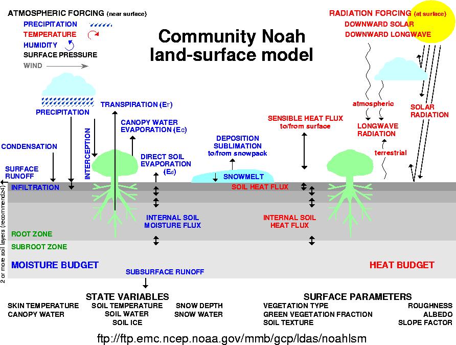
2 Improving the Global Land Surface Climatology via improved Global Land Data Assimilation System (GLDAS) NCEP operational GLDAS Upgraded Noah land model Higher-resolution land data sets, i.e. vegetation, soils, vegetation phenology (near-realtime), etc. Improved forcing, especially precipitation Land data assimilation (e.g. snow, soil moisture) Land model spin-up Including river routing to complete water cycle 2
3 3
 forced with CFSv2/GDAS atmospheric data assimilation")

 & GDAS (modeled; high latitude--gauges sparse, satellite obs lack")
, else adjusted to 0.5 or 2.")
4 Global Land Data Assimilation System (GLDAS) GLDAS (runs Noah land surface model (LSM) under NASA/Land Information System (LIS) forced with CFSv2/GDAS atmospheric data assimilation output & blended precipitation in a semi-coupled mode. Blended precipitation via satellite (CPC/CMAP; heaviest weight in tropics--satellite observations more accurate & surface gauges sparse), gauge (heaviest in mid-latitudes where gauge density highest) & GDAS (modeled; high latitude--gauges sparse, satellite obs lack accuracy). Snow cycled in CFSv2/GLDAS if model within 0.5x to 2.0x observed value (IMS snow cover & AFWA snow depth products), else adjusted to 0.5 or 2.0 of observed value. GDAS CMAP precip Gauge locations IMS snow cover AFWA snow depth 4
5 NCEP Realtime Operational GLDAS/LIS Land Surface Characteristics Topography Land Cover Soil Precipitation Forcing Non-precip Meteorological Forcing Land Variables Soil Moisture Soil Temperature Snow Noah LSM Land Information System Christa Peters-Lidard et al., NASA/GSFC/HSB CFS/GFS land analysis Soil Moisture Soil Temperature Snow CFS/GFS land initial conditions gdas1.t00z.sfcanl 5
. Forcing: CFSR surface forcing and blended (obs+model) precip forcing. Initial condition: Spin up land states for 1 January, 1979.")
6 GLDAS Global Land Surface Climatology Motivation: CFSR was executed in 6 streams, discontinuity at stream boundaries. Solution: One stream GLDAS (1979 realtime). Configuration: Same as CFSR (LIS T382). Forcing: CFSR surface forcing and blended (obs+model) precip forcing. Initial condition: Spin up land states for 1 January, Spin up: 15 years (5 repeating year of 2003; followed by 10 repeating year of 1979) 6
7 NCEP Realtime Operational GLDAS CDAS/GDAS Atmospheric analysis Day 1 Day 2 Day 3 Day 4 Day 5 Day 6 Day 7 Day 8 GLDAS Land analysis GLDAS Land analysis Precip observation Precip observation 7

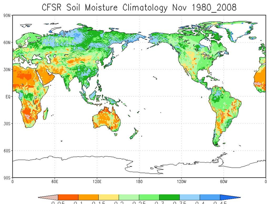
8 GLDAS soil moisture climatology 8
9 GLDAS soil moisture anomaly 9
10 GLDAS soil moisture anomaly Russian drought Uganda flood US drought Global Drought (Flood) Monitor 10


11 NLDAS Support for NCEP/CPC Drought Monitoring and Assessment Activity 11

12 Drought is a natural hazard around the world. Expand the current NLDAS drought monitor and prediction applications to global is desired. 12
 6: broadleaf trees with groundcover 7: groundcover only (perennial) 8: broadleaf shrubs with perennial groundcover 9: broadleaf")

13 Vegetation Types: SIB vs IGBP 1: broadleaf evergreen trees! 2: broadleaf deciduous trees 3: broadleaf and needleleaf trees! 4: needleleaf evergreen trees 5: needleleaf deciduous trees (larch) 6: broadleaf trees with groundcover 7: groundcover only (perennial) 8: broadleaf shrubs with perennial groundcover 9: broadleaf shrubs with bare soil 10: dwarf trees and shrubs with groundcover (tundra) 11: bare soil 12: cultivations (the same parameters as for type 7) 13: glacial ice 1:Evergreen Needleleaf Forest 2:Evergreen Broadleaf Forest 3:Deciduous Needleleaf Forest 4:Deciduous Broadleaf Forest 5:Mixed Forests 6:Closed Shrublands 7:Open Shrublands 8:Woody Savannas 9:Savannas 10:Grasslands 11:Permanent wetlands 12:Croplands 13:Urban and Built Up 14:Cropland/natural vegetation mosaic 15:Snow and Ice 16:Barren or Sparsely Vegetated 17:Water 18:Wooded Tundra 19:Mixed Tundra 20:Bare Ground Tundra 13


 17: playa 18: lava 19:")
14 Soil Types: ZOBLER vs STASGO 1 loamy sand 2 silty clay loam 3 light clay 4 sandy loam 5 sandy clay 6 clay loam 7 sandy clay loam 8 loam 9 loamy sand 1: sand 2: loamy sand 3: sandy loam 4: silt loam 5: silt 6:loam 7:sandy clay loam 8:silty clay loam 9:clay loam 10:sandy clay 11: silty clay 12: clay 13: organic material 14: water 15: bedrock 16: other (land ice) 17: playa 18: lava 19: white sand 14

15 A Gauge-Satellite Blended Analysis of Daily Precipitation for Hydrometeorological Applications 0.25 o lat/lon over the global land Daily analysis from 1979 Blending information from different sources to overcome shortcomings CPC daily gauge analysis adjusted to GPCC monthly gauge data to correct the under-estimation in daily reports OLR-based precipitation estimates derived through calibration against CMORPH Daily gauge data and OLR precip combined to produce a precipitation analysis with long-term homogeneity and quantitative accuracy Right figure: sample for Jul. 15,
16 DATA ASSIMILATION: SNOW An improved land data assimilation component in GLDAS will decrease errors and improve the quality of the reanalysis. This would be a first effort that targets incorporating extensive satellite observations of land data sets into a NOAA/NCEP operational global reanalysis. MODIS Snow Cover DA SMMR SWE DA Comparison of snow water equivalent between the open loop simulation (green), the assimilation simulation (red) and the in situ measurement (black) averaged over all SNOTEL sites in the study region. Comparison of the median SWE for pixels including 5 or more stations; ground observations (black dots), SMMR observations (plus), model forecast (dash lines), model forecast with assimilation run I (dotted lines) and run II (solid lines) from (a) January to March in 1979 and (b) from July 1986 to June 1987 (zoomed to the winter months from October 1986 to April 1987). 16
 require the 4 5 years spin up time.")
17 SPINUP STRATEGY SPINUP: 1986 SPINUP: 1985 Precipitation is a major factor affecting spinup time. Regions with annual precipitation over 1000m (NE and SE) requires spinup time less than 1 year. Regions with annual precipitation between 500mm and 1000mm (CE and NW) require the 4 5 years spin up time. Regions with annual precipitation less than 500mm (NC and SW) requires nearly 10 year spinup time. Temperature affects model spinup time in dry regions. SPINUP: 1985&1986 SPINUP: 1984&1985 CFSR ran with six simultaneous streams (separate runs) over the 32 year period ( ) with the issue of discontinuity of evolving land states. A sufficient spin up process for each single stream is required to maintain the continuity of land states. 17
 Hurricane Irene and Tropical Storm Lee 20 August 17 September 2011")
18 Streamflow from NLDAS routing scheme Ensemble mean daily streamflow anomaly (m 3 /s) Hurricane Irene and Tropical Storm Lee 20 August 17 September
 Superstorm Sandy 29 October 04")
19 Streamflow from NLDAS routing scheme Ensemble mean daily streamflow anomaly (m 3 /s) Superstorm Sandy 29 October 04 November
20 Summary Improved GLDAS Upgraded Noah land model Higher-resolution land data sets, i.e. vegetation, soils, vegetation phenology (near-realtime), etc. Improved forcing, especially precipitation Land data assimilation (e.g. snow, soil moisture) Land model spin-up Include river routing to complete water cycle Land surface initial states (ensemble) for S2S prediction experiments 20
Land Analysis in the NOAA CFS Reanalysis. Michael Ek, Ken Mitchell, Jesse Meng Helin Wei, Rongqian Yang, and George Gayno
 Land Analysis in the NOAA CFS Reanalysis Michael Ek, Ken Mitchell, Jesse Meng Helin Wei, Rongqian Yang, and George Gayno 1 Outline CFS Reanalysis execution Land surface model upgrade from OSU to Noah LIS/GLDAS
Implementation of Land Information System in the NCEP Operational Climate Forecast System CFSv2. Jesse Meng, Michael Ek, Rongqian Yang, Helin Wei
 Implementation of Land Information System in the NCEP Operational Climate Forecast System CFSv2 Jesse Meng, Michael Ek, Rongqian Yang, Helin Wei 1 Outline NCEP CFSRR Land component CFSv1 vs CFSv2 Land
Michael B. Ek 1, Youlong Xia 1,2, Jesse Meng 1,2, and Jiarui Dong 1,2
 Michael B. Ek 1, Youlong Xia 1,2, Jesse Meng 1,2, and Jiarui Dong 1,2 1 Land-Hydrology Team Environmental Modeling Center (EMC) National Centers for Environmental Prediction (NCEP) National Weather Service
Using VIIRS Land Surface Temperature to Evaluate NCEP North American Mesoscale Model (NAM) Forecast
 Forecast") Using VIIRS Land Surface Temperature to Evaluate NCEP North American Mesoscale Model (NAM) Forecast Zhuo Wang (University of Maryland) Yunyue Yu (NOAA/NESDIS/STAR) Peng Yu (University of Maryland) Yuling
Using VIIRS Land Surface Temperature to Evaluate NCEP North American Mesoscale Model (NAM) Forecast Zhuo Wang (University of Maryland) Yunyue Yu (NOAA/NESDIS/STAR) Peng Yu (University of Maryland) Yuling
Land Data Assimilation at NCEP NLDAS Project Overview, ECMWF HEPEX 2004
 Dag.Lohmann@noaa.gov, Land Data Assimilation at NCEP NLDAS Project Overview, ECMWF HEPEX 2004 Land Data Assimilation at NCEP: Strategic Lessons Learned from the North American Land Data Assimilation System
An Ensemble Land Surface Modeling and Assimilation Testbed for HEPEX
 GSFC s Land Data Assimilation Systems: An Ensemble Land Surface Modeling and Assimilation Testbed for HEPEX Christa Peters-Lidard Lidard,, Paul Houser, Matthew Rodell, Brian Cosgrove NASA Goddard Space
First steps toward a comparison of modelled thermal comfort during a heatwave in Melbourne, Australia
 First steps toward a comparison of modelled thermal comfort during a heatwave in Melbourne, Australia Stephanie Jacobs PhD supervisors: Ailie Gallant and Nigel Tapper Outline of talk Motivation for research
Comparison of NASA AIRS and MODIS Land Surface Temperature and Infrared Emissivity Measurements from the EOS AQUA platform
 Comparison of NASA AIRS and MODIS Land Surface Temperature and Infrared Emissivity Measurements from the EOS AQUA platform Robert Knuteson, Hank Revercomb, Dave Tobin University of Wisconsin-Madison 16
Assimilation of the AFWA Snow Depth Product into NCEP Operational CFS/GFS System
 Assimilation of the AFWA Snow Depth Product into NCEP Operational CFS/GFS System Jiarui Dong, Mie E NOAA/NCEP/EMC, College Par, Maryland, USA Sujay Kumar, Christa Peters-Lidard NASA/GSFC, Greenbelt, Maryland,
Patrick Leinenkugel. German Aerospace Center (DLR) Vortrag > Autor > Dokumentname > Datum
 Vortrag > Autor > Dokumentname > Datum") Characterisation of land surface phenology and land cover for the Mekong Basin on the basis of multitemporal and multispectral satellite data from the MODIS Sensor Patrick Leinenkugel German Aerospace
Characterisation of land surface phenology and land cover for the Mekong Basin on the basis of multitemporal and multispectral satellite data from the MODIS Sensor Patrick Leinenkugel German Aerospace
Cross-Sensor Continuity Science Algorithm
 Cross-Sensor Continuity Science Algorithm - Long Term Vegetation Index and Phenology Workshop - Javzan Tsend-Ayush and Tomoaki Miura Department of Natural Resources and Environmental Management University
AGOG 485/585 /APLN 533 Spring Lecture 5: MODIS land cover product (MCD12Q1). Additional sources of MODIS data
. Additional sources of MODIS data") AGOG 485/585 /APLN 533 Spring 2019 Lecture 5: MODIS land cover product (MCD12Q1). Additional sources of MODIS data Outline Current status of land cover products Overview of the MCD12Q1 algorithm Mapping
AGOG 485/585 /APLN 533 Spring 2019 Lecture 5: MODIS land cover product (MCD12Q1). Additional sources of MODIS data Outline Current status of land cover products Overview of the MCD12Q1 algorithm Mapping
Interaction of North American Land Data Assimilation System and National Soil Moisture Network: Soil Products and Beyond
 Interaction of North American Land Data Assimilation System and National Soil Moisture Network: Soil Products and Beyond Youlong Xia 1,2, Michael B. Ek 1, Yihua Wu 1,2, Christa Peters-Lidard 3, David M.
Changes in Seasonal Albedo with Land Cover Class
 Name: Date: Changes in Seasonal Albedo with Land Cover Class Guiding question: How does albedo change over the seasons in different land cover classes? Introduction. Now that you have completed the Introduction
Improving Streamflow Prediction in Snow- fed River Basins via Satellite Snow Assimilation
 Improving Streamflow Prediction in Snow- fed River Basins via Satellite Snow Assimilation Yuqiong Liu NASA GSFC & University of Maryland, College Park Co- authors: Christa Peters- Lidard, Sujay Kumar,
Comparison of NASA AIRS and MODIS Land Surface Temperature and Infrared Emissivity Measurements from the EOS AQUA platform
 Comparison of NASA AIRS and MODIS Land Surface Temperature and Infrared Emissivity Measurements from the EOS AQUA platform Robert Knuteson, Steve Ackerman, Hank Revercomb, Dave Tobin University of Wisconsin-Madison
Efforts to Assimilate the AFWA Snow Depth Product into NCEP Operational CFS/GFS System
 Efforts to Assimilate the AFWA Snow Depth Product into NCEP Operational CFS/GFS System J. Dong, Mie E, W. Zheng, H. Wei, J. Meng NOAA/NCEP/EMC, College Par, Maryland, USA X. Zhan NOAA/NESDIS/STAR, College
NCEP Land-Surface Modeling
 NCEP Land-Surface Modeling Michael Ek and the EMC Land-Hydrology Team Environmental Modeling Center (EMC) National Centers for Environmental Prediction (NCEP) 5200 Auth Road, Room 207 Suitland, Maryland
GRID RAINFALL DISAGGREGATION TOWARD A PATCH-BASED ENSEMBLE KALMAN FILTER FOR SOIL MOISTURE DATA ASSIMILATION
 GRID RAINFALL DISAGGREGATION TOWARD A PATCH-BASED ENSEMBLE KALMAN FILTER FOR SOIL MOISTURE DATA ASSIMILATION Filip Jagodzinski, Villanova University, Bryn Mawr, PA (filip.jagodzinski@villanova.edu) Mentor:
Multivariate assimilation of satellite-derived remote sensing datasets in the North American Land Data Assimilation System (NLDAS)
") Multivariate assimilation of satellite-derived remote sensing datasets in the North American Land Data Assimilation System (NLDAS) Sujay V. Kumar 1,2, Christa D. Peters-Lidard 1, David Mocko 1,2,3, Rolf
Multivariate assimilation of satellite-derived remote sensing datasets in the North American Land Data Assimilation System (NLDAS) Sujay V. Kumar 1,2, Christa D. Peters-Lidard 1, David Mocko 1,2,3, Rolf
Analysis of real-time prairie drought monitoring and forecasting system. Lei Wen and Charles A. Lin
 Analysis of real-time prairie drought monitoring and forecasting system Lei Wen and Charles A. Lin Back ground information A real-time drought monitoring and seasonal prediction system has been developed
Dear Editor, Response to Anonymous Referee #1. Comment 1:
 Dear Editor, We would like to thank you and two anonymous referees for the opportunity to revise our manuscript. We found the comments of the two reviewers very useful, which gave us a possibility to address
Land-Hydrology Modeling at NCEP
 Land-Hydrology Modeling at NCEP Michael Ek 1 *, Jesse Meng 1, Rongqian Yang 1, Helin Wei 1, Vince Wong 1, Youlong Xia 1, Yihua Wu 1, Weizhong Zheng 1, Jiarui Dong 1, and Sid Katz 2 NOAA (National Oceanic
Status report on the La Plata Basin (LPB) - A CLIVAR/GEWEX Continental Scale Experiment
 - A CLIVAR/GEWEX Continental Scale Experiment") Status report on the La Plata Basin (LPB) - A CLIVAR/GEWEX Continental Scale Experiment Hugo Berbery and Maria A. Silva Dias (Co-chairs for CLIVAR/VAMOS and GEWEX/GHP) with contributions of the LPB ISG
Status report on the La Plata Basin (LPB) - A CLIVAR/GEWEX Continental Scale Experiment Hugo Berbery and Maria A. Silva Dias (Co-chairs for CLIVAR/VAMOS and GEWEX/GHP) with contributions of the LPB ISG
Soil Moisture Prediction and Assimilation
 Soil Moisture Prediction and Assimilation Analysis and Prediction in Agricultural Landscapes Saskatoon, June 19-20, 2007 STEPHANE BELAIR Meteorological Research Division Prediction and Assimilation Atmospheric
Global Biogeography. Natural Vegetation. Structure and Life-Forms of Plants. Terrestrial Ecosystems-The Biomes
 Global Biogeography Natural Vegetation Structure and Life-Forms of Plants Terrestrial Ecosystems-The Biomes Natural Vegetation natural vegetation is the plant cover that develops with little or no human
Celebrating the Climate Prediction Center s 25 th Anniversary: Current NCEP Climate Activities
 Celebrating the Climate Prediction Center s 25 th Anniversary: Current NCEP Climate Activities Louis W. Uccellini Director, NCEP The 29 th Climate Diagnostics and Prediction Workshop University of Wisconsin,
NIDIS Intermountain West Drought Early Warning System April 18, 2017
 1 of 11 4/18/2017 3:42 PM Precipitation NIDIS Intermountain West Drought Early Warning System April 18, 2017 The images above use daily precipitation statistics from NWS COOP, CoCoRaHS, and CoAgMet stations.
Florida Commission on Hurricane Loss Projection Methodology Flood Standards Development Committee. October 30, 2014
 Florida Commission on Hurricane Loss Projection Methodology Flood Standards Development Committee October 30, 2014 KatRisk LLC 752 Gilman St. Berkeley, CA 94710 510-984-0056 www.katrisk.com About KatRisk
CH. 3: Climate and Vegetation
 CH. 3: Climate and Vegetation GROUP WORK RUBRIC Score of 50 (5): Superior - 100% A 5 is superior work, and has completed all requirements of the assignments, it is in order and its presentation is almost
DEVELOPMENT OF GPS PHOTOS DATABASE FOR LAND USE AND LAND COVER APPLICATIONS
 DEVELOPMENT OF GPS PHOTOS DATABASE FOR LAND USE AND LAND COVER APPLICATIONS An Ngoc VAN and Wataru TAKEUCHI Institute of Industrial Science University of Tokyo 4-6-1 Komaba, Meguro-ku, Tokyo 153-8505 Japan
Evaluation of the ERA-40 surface water budget and surface temperature for the Mackenzie River basin.
 1 Evaluation of the ERA-4 surface water budget and surface temperature for the Mackenzie River basin. Alan K. Betts* and John H. Ball Atmospheric Research, Pittsford, Vermont Pedro Viterbo ECMWF, Reading,
Prediction of Snow Water Equivalent in the Snake River Basin
 Hobbs et al. Seasonal Forecasting 1 Jon Hobbs Steve Guimond Nate Snook Meteorology 455 Seasonal Forecasting Prediction of Snow Water Equivalent in the Snake River Basin Abstract Mountainous regions of
Chapter 7 Part III: Biomes
 Chapter 7 Part III: Biomes Biomes Biome: the major types of terrestrial ecosystems determined primarily by climate 2 main factors: Temperature and precipitation Depends on latitude or altitude; proximity
Enhancing Weather Forecasts via Assimilating SMAP Soil Moisture and NRT GVF
 CICS Science Meeting, ESSIC, UMD, 2016 Enhancing Weather Forecasts via Assimilating SMAP Soil Moisture and NRT GVF Li Fang 1,2, Christopher Hain 1,2, Xiwu Zhan 2, Min Huang 1,2 Jifu Yin 1,2, Weizhong Zheng
APPLICATIONS OF DOWNSCALING: HYDROLOGY AND WATER RESOURCES EXAMPLES
 APPLICATIONS OF DOWNSCALING: HYDROLOGY AND WATER RESOURCES EXAMPLES Dennis P. Lettenmaier Department of Civil and Environmental Engineering For presentation at Workshop on Regional Climate Research NCAR
Land surface precipitation and hydrology in MERRA-2
 Land surface precipitation and hydrology in MERRA-2 R. Reichle, R. Koster, C. Draper, Q. Liu, M. Girotto, S. Mahanama, G. De Lannoy, G. Partyka, and many others 5th International Conference on Reanalysis
NIDIS Intermountain West Drought Early Warning System December 11, 2018
 NIDIS Drought and Water Assessment NIDIS Intermountain West Drought Early Warning System December 11, 2018 Precipitation The images above use daily precipitation statistics from NWS COOP, CoCoRaHS, and
16 Global Climate. Learning Goals. Summary. After studying this chapter, students should be able to:
 16 Global Climate Learning Goals After studying this chapter, students should be able to: 1. associate the world s six major vegetation biomes to climate (pp. 406 408); 2. describe methods for classifying
VIC Hydrology Model Training Workshop Part II: Building a model
 VIC Hydrology Model Training Workshop Part II: Building a model 11-12 Oct 2011 Centro de Cambio Global Pontificia Universidad Católica de Chile Ed Maurer Civil Engineering Department Santa Clara University
Regional offline land surface simulations over eastern Canada using CLASS. Diana Verseghy Climate Research Division Environment Canada
 Regional offline land surface simulations over eastern Canada using CLASS Diana Verseghy Climate Research Division Environment Canada The Canadian Land Surface Scheme (CLASS) Originally developed for the
D. Lohmann, Pablo Grunman, and Kenneth Mitchell (2004), Land data assimilation at NOAA/NCEP/EMC, in Proceedings of the 2 nd international CAHMDA
, Land data assimilation at NOAA/NCEP/EMC, in Proceedings of the 2 nd international CAHMDA") D. Lohmann, Pablo Grunman, and Kenneth Mitchell (2004), Land data assimilation at NOAA/NCEP/EMC, in Proceedings of the 2 nd international CAHMDA workshop on: The Terrestrial Water Cycle: Modelling and
D. Lohmann, Pablo Grunman, and Kenneth Mitchell (2004), Land data assimilation at NOAA/NCEP/EMC, in Proceedings of the 2 nd international CAHMDA workshop on: The Terrestrial Water Cycle: Modelling and
NIDIS Intermountain West Regional Drought Early Warning System February 7, 2017
 NIDIS Drought and Water Assessment NIDIS Intermountain West Regional Drought Early Warning System February 7, 2017 Precipitation The images above use daily precipitation statistics from NWS COOP, CoCoRaHS,
The Canadian Precipitation Analysis (CaPA) and the Canadian Land Data Assimilation System (CaLDAS)
 and the Canadian Land Data Assimilation System (CaLDAS)") The Canadian Precipitation Analysis (CaPA) and the Canadian Land Data Assimilation System (CaLDAS) Vincent Fortin (and many collaborators) Division de la recherche en météorologie Environnement en Changement
The Canadian Precipitation Analysis (CaPA) and the Canadian Land Data Assimilation System (CaLDAS) Vincent Fortin (and many collaborators) Division de la recherche en météorologie Environnement en Changement
What Determines the Amount of Precipitation During Wet and Dry Years Over California?
 NOAA Research Earth System Research Laboratory Physical Sciences Division What Determines the Amount of Precipitation During Wet and Dry Years Over California? Andy Hoell NOAA/Earth System Research Laboratory
Estimation via Data Assimilation Using. Mississippi State University GeoResources Institute
 High Resolution Soil Moisture Estimation via Data Assimilation Using NASA Land Information System Mississippi State University GeoResources Institute LIS Evaluation Team & Collaborators RPC Team Valentine
forest tropical jungle swamp marsh prairie savanna pampas Different Ecosystems (rainforest)
") Different Ecosystems forest A region of land that is covered with many trees and shrubs. tropical jungle (rainforest) swamp A region with dense trees and a variety of plant life. It has a tropical climate.
Different Ecosystems forest A region of land that is covered with many trees and shrubs. tropical jungle (rainforest) swamp A region with dense trees and a variety of plant life. It has a tropical climate.
Earth s Major Terrerstrial Biomes. *Wetlands (found all over Earth)
") Biomes Biome: the major types of terrestrial ecosystems determined primarily by climate 2 main factors: Depends on ; proximity to ocean; and air and ocean circulation patterns Similar traits of plants
Biomes Biome: the major types of terrestrial ecosystems determined primarily by climate 2 main factors: Depends on ; proximity to ocean; and air and ocean circulation patterns Similar traits of plants
Application and impacts of the GlobeLand30 land cover dataset on the Beijing Climate Center Climate Model
 IOP Conference Series: Earth and Environmental Science PAPER OPEN ACCESS Application and impacts of the GlobeLand30 land cover dataset on the Beijing Climate Center Climate Model To cite this article:
NIDIS Intermountain West Drought Early Warning System November 21, 2017
 NIDIS Drought and Water Assessment NIDIS Intermountain West Drought Early Warning System November 21, 2017 Precipitation The images above use daily precipitation statistics from NWS COOP, CoCoRaHS, and
Greenbelt, MD 20771, USA. Available online: 10 Apr Full terms and conditions of use:
 This article was downloaded by: [University of Oklahoma Libraries] On: 29 October 2011, At: 14:32 Publisher: Taylor & Francis Informa Ltd Registered in England and Wales Registered Number: 1072954 Registered
NASA/NOAA s Global Land Data Assimilation System (GLDAS): Recent Results and Future Plans
: Recent Results and Future Plans") NASA/NOAA s Global Land Data Assimilation System (GLDAS): Recent Results and Future Plans Matthew Rodell with contributions from Paul Houser, Christa Peters-Lidard, Hiroko Kato, Sujay Kumar, Jon Gottschalck,
NASA/NOAA s Global Land Data Assimilation System (GLDAS): Recent Results and Future Plans Matthew Rodell with contributions from Paul Houser, Christa Peters-Lidard, Hiroko Kato, Sujay Kumar, Jon Gottschalck,
Consistent Parameterization of Roughness Length and Displacement Height for Sparse and Dense Canopies in Land Models
 730 J O U R N A L O F H Y D R O M E T E O R O L O G Y S P E C I A L S E C T I O N VOLUME 8 Consistent Parameterization of Roughness Length and Displacement Height for Sparse and Dense Canopies in Land
The Delaware Environmental Monitoring & Analysis Center
 The Delaware Environmental Monitoring & Analysis Center Tina Callahan Delaware Estuary Science & Environmental Summit 2013 January 27-30, 2013 What is DEMAC? Delaware Environmental Monitoring & Analysis
Climate Impacts to Southwest Water Sector. Dr. Dave DuBois New Mexico State Climatologist
 Climate Impacts to Southwest Water Sector Dr. Dave DuBois New Mexico State Climatologist Presented at EPA Extreme Events and Climate Adaptation Planning Workshop June 3, 2015 Water Year Precip. % of Average
Overlay Analysis II: Using Zonal and Extract Tools to Transfer Raster Values in ArcMap
 Overlay Analysis II: Using Zonal and Extract Tools to Transfer Raster Values in ArcMap Created by Patrick Florance and Jonathan Gale, Edited by Catherine Ressijac on March 26, 2018 If you have raster data
The National Operational Hydrologic Remote Sensing Center Operational Snow Analysis
 The National Operational Hydrologic Remote Sensing Center Operational Snow Analysis World Meteorological Organization Global Cryosphere Watch Snow-Watch Workshop Session 3: Snow Analysis Products Andrew
Flood Forecasting Tools for Ungauged Streams in Alberta: Status and Lessons from the Flood of 2013
 Flood Forecasting Tools for Ungauged Streams in Alberta: Status and Lessons from the Flood of 2013 John Pomeroy, Xing Fang, Kevin Shook, Tom Brown Centre for Hydrology, University of Saskatchewan, Saskatoon
Georgy V. Mostovoy*¹, Valentine Anantharaj¹, Paul R. Houser², and Christa D. Peters-Lidard³
 P2.3 USE OF SCAN OBSERVATIONS FOR VALIDATION OF SOIL MOISTURE SPATIAL DISTRIBUTION SIMULATED BY THE LAND-SURFACE MODEL OVER THE LOWER MISSISSIPPI DELTA REGION Georgy V. Mostovoy*¹, Valentine Anantharaj¹,
JRA-55 Product Users Handbook
 Climate Prediction Division Global Environment and Marine Department Japan Meteorological Agency March 2014 Change record Version Date Remarks 1.0 3 March 2014 First version 2 Contents 1. Introduction...
Recent updates of the UW/CIMSS high spectral resolution global land surface infrared emissivity database
 Recent updates of the UW/CIMSS high spectral resolution global land surface infrared emissivity database Eva E. Borbas, Suzanne Wetzel Seemann, Robert O. Knuteson, Elisabeth Weisz, and Allen Huang Space
Precipitation: Evapotranspiration: S i o l il M o t s ure: Groundwater: Streamflow: Vegetation:
 Satellite and Ground-based Approaches for Monitoring Impacts of Agriculture on Ground Resources Bridget R. Scanlon, Laurent Longuevergne, Guillaume Favreau*, Claudia Faunt** Center for Sustainable Water
David R. Vallee Hydrologist-in-Charge NOAA/NWS Northeast River Forecast Center
 David R. Vallee Hydrologist-in-Charge NOAA/NWS Northeast River Forecast Center Record flooding along the Shawsheen River during the 2006 Mother s Day Floods Calibrate and implement a variety of hydrologic
CWRF Downscaling to Improve U.S. Seasonal- Interannual Climate Predic>on
 CWRF Downscaling to Improve U.S. Seasonal- Interannual Climate Predic>on Xin-Zhong Liang 1,2, Ligang Chen 2, Shenjian Su 2, Julian X.L. Wang 3 1 Department of Atmosphere & Ocean Science 2011 December 7
Behind the Climate Prediction Center s Extended and Long Range Outlooks Mike Halpert, Deputy Director Climate Prediction Center / NCEP
 Behind the Climate Prediction Center s Extended and Long Range Outlooks Mike Halpert, Deputy Director Climate Prediction Center / NCEP September 2012 Outline Mission Extended Range Outlooks (6-10/8-14)
The CMC Monthly Forecasting System
 The CMC Monthly Forecasting System Hai Lin Meteorological Research Division RPN seminar May 20, 2011 Acknowledgements Support and help from many people Gilbert Brunet, Bernard Dugas, Juan-Sebastian Fontecilla,
Funding provided by NOAA Sectoral Applications Research Project CLIMATE. Basic Climatology Colorado Climate Center
 Funding provided by NOAA Sectoral Applications Research Project CLIMATE Basic Climatology Colorado Climate Center Remember These? Factor 1: Our Energy Source Factor 2: Revolution & Tilt Factor 3: Rotation!
Evaluation of the ERA-40 Surface Water Budget and Surface Temperature for the Mackenzie River Basin
 1194 JOURNAL OF HYDROMETEOROLOGY VOLUME 4 Evaluation of the ERA-40 Surface Water Budget and Surface Temperature for the Mackenzie River Basin ALAN K. BETTS AND JOHN H. BALL Atmospheric Research, Pittsford,
What is a Biome? An Overview of Biomes. The Holdridge Life Zones. Tundra 9/14/2010. In the following slides, you ll
 An Overview of Biomes What is a Biome? A biome describes a habitat type Biomes are primarily described by average temperature, annual precipitation, length of growing season, and dominant vegetation type
Upper Missouri River Basin December 2017 Calendar Year Runoff Forecast December 5, 2017
 Upper Missouri River Basin December 2017 Calendar Year Runoff Forecast December 5, 2017 Calendar Year Runoff Forecast Explanation and Purpose of Forecast U.S. Army Corps of Engineers, Northwestern Division
Your Creekside at Bethpage Weather with 2017 Forecasts. By Kevin Walls
 Your Creekside at Bethpage Weather with 2017 Forecasts By Kevin Walls Lets discuss. What are the Weather Extremes? Why are our wind patterns always the same? What are the causes of our weather patterns?
Challenges in forecasting the MJO
 Challenges in forecasting the MJO Augustin Vintzileos University of Maryland ESSIC/CICS-MD Jon Gottschalck NOAA/NCEP/CPC Outline Forecasting at the interface between weather and climate Multi-scale impacts
Inter-linkage case study in Pakistan
 7 th GEOSS Asia Pacific Symposium GEOSS AWCI Parallel Session: 26-28 May, 2014, Tokyo, Japan Inter-linkage case study in Pakistan Snow and glaciermelt runoff modeling in Upper Indus Basin of Pakistan Maheswor
How does the physical environment influence communities and ecosystems? Hoodoos in Cappadocia, Turkey
 Biomes of the World How does the physical environment influence communities and ecosystems? Hoodoos in Cappadocia, Turkey ecosystems are shaped by: abiotic factors climate/weather space Rainfall Soil air
Operational Perspectives on Hydrologic Model Data Assimilation
 Operational Perspectives on Hydrologic Model Data Assimilation Rob Hartman Hydrologist in Charge NOAA / National Weather Service California-Nevada River Forecast Center Sacramento, CA USA Outline Operational
Colorado weather and climate update: a bit more than halfway through the water year (Or: What s going on with the weather?? )
") Colorado weather and climate update: a bit more than halfway through the water year (Or: What s going on with the weather?? ) Russ S. Schumacher Colorado State Climatologist Director, Colorado Climate
Colorado weather and climate update: a bit more than halfway through the water year (Or: What s going on with the weather?? ) Russ S. Schumacher Colorado State Climatologist Director, Colorado Climate
WATER AND ENERGY BALANCE ESTIMATION IN PUERTO RICO USING SATELLITE REMOTE SENSING
 WATER AND ENERGY BALANCE ESTIMATION IN PUERTO RICO USING SATELLITE REMOTE SENSING Eric. W. Harmsen, Ariel Mercado Vargas, Pedro Tosado Cruz, Jonellys M Maldonado Morales and Angel O. Ortiz Lozada OCTAVA
NIDIS Intermountain West Drought Early Warning System May 23, 2017
 NIDIS Drought and Water Assessment NIDIS Intermountain West Drought Early Warning System May 23, 2017 Precipitation The images above use daily precipitation statistics from NWS COOP, CoCoRaHS, and CoAgMet
Biosphere Organization
 Biosphere Organization What is a biome? Biomes refer to a large region or area characterized by the following: 1. A particular climate pattern of the annual temperature and precipitation distribution,
Terrestrial Snow Cover: Properties, Trends, and Feedbacks. Chris Derksen Climate Research Division, ECCC
 Terrestrial Snow Cover: Properties, Trends, and Feedbacks Chris Derksen Climate Research Division, ECCC Outline Three Snow Lectures: 1. Why you should care about snow: Snow and the cryosphere Classes of
The US MOPEX Data Set
 Large Sample Basin Experiments for Hydrological Model Parameterization: Results of the Model Parameter Experiment MOPEX. IAHS Publ. 307, 2006. 9 The US MOPEX Data Set JOHN SCHAAKE 1, SHUZHENG CONG 1 &
NIDIS Intermountain West Drought Early Warning System December 18, 2018
 NIDIS Intermountain West Drought Early Warning System December 18, 2018 Precipitation The images above use daily precipitation statistics from NWS COOP, CoCoRaHS, and CoAgMet stations. From top to bottom,
Seasonal and interannual relations between precipitation, soil moisture and vegetation in the North American monsoon region
 Seasonal and interannual relations between precipitation, soil moisture and vegetation in the North American monsoon region Luis A. Mendez-Barroso 1, Enrique R. Vivoni 1, Christopher J. Watts 2 and Julio
A Description and Example Output of the WRF-NMM land surface and radiation packages used at NCEP
 A Description and Example Output of the WRF-NMM land surface and radiation packages used at NCEP Ken Mitchell and Michael Ek NCEP/EMC NOAA/NWS WRF-NMM Tutorial 8-11 August 2006 Boulder, CO Noah Land Surface
Cloud Analysis Image: Product Guide
 Cloud Analysis Image: Product Guide Doc.No. : EUM/TSS/MAN/15/795729 EUMETSAT Eumetsat-Allee 1, D-64295 Darmstadt, Germany Tel: +49 6151 807-7 Issue : v1c Fax: +49 6151 807 555 Date : 19 February 2015 http://www.eumetsat.int
THE NCEP CLIMATE FORECAST SYSTEM. Suranjana Saha, ensemble workshop 5/10/2011 THE ENVIRONMENTAL MODELING CENTER NCEP/NWS/NOAA
 THE NCEP CLIMATE FORECAST SYSTEM Suranjana Saha, ensemble workshop 5/10/2011 THE ENVIRONMENTAL MODELING CENTER NCEP/NWS/NOAA An upgrade to the NCEP Climate Forecast System (CFS) was implemented in late
A Near Real Time Drought Monitoring Capability
 A Near Real Time Drought Monitoring Capability Kingtse Mo, Muthuvel Chelliah, Wayne Higgins and The NCEP Drought Monitoring Team Climate Prediction Center NCEP/NWS/NOAA An Experimental Drought Early Warning
Drought Monitoring in Mainland Portugal
 Drought Monitoring in Mainland Portugal 1. Accumulated precipitation since 1st October 2014 (Hydrological Year) The accumulated precipitation amount since 1 October 2014 until the end of April 2015 (Figure
Precipitation. Standardized Precipitation Index. NIDIS Intermountain West Regional Drought Early Warning System January 3, 2017
 1/3/2017 NIDIS Drought and Water Assessment NIDIS Intermountain West Regional Drought Early Warning System January 3, 2017 Precipitation The images above use daily precipitation statistics from NWS COOP,
DROUGHT ASSESSMENT USING SATELLITE DERIVED METEOROLOGICAL PARAMETERS AND NDVI IN POTOHAR REGION
 DROUGHT ASSESSMENT USING SATELLITE DERIVED METEOROLOGICAL PARAMETERS AND NDVI IN POTOHAR REGION Researcher: Saad-ul-Haque Supervisor: Dr. Badar Ghauri Department of RS & GISc Institute of Space Technology
Climate: long term average weather. Use climograph to display climate data. Climograph
 March 27, 2014: Introduction to climate. If you have not yet taken Exam 1 or Exam 2, please email me to set up a time to take a makeup. All makeup exams should be completed before taking Exam 3. Climate:
CERA-SAT: A coupled reanalysis at higher resolution (WP1)
") CERA-SAT: A coupled reanalysis at higher resolution (WP1) ERA-CLIM2 General assembly Dinand Schepers 16 Jan 2017 Contributors: Eric de Boisseson, Per Dahlgren, Patrick Lalolyaux, Iain Miller and many others
CERA-SAT: A coupled reanalysis at higher resolution (WP1) ERA-CLIM2 General assembly Dinand Schepers 16 Jan 2017 Contributors: Eric de Boisseson, Per Dahlgren, Patrick Lalolyaux, Iain Miller and many others
Geostatistical Analysis of Rainfall Temperature and Evaporation Data of Owerri for Ten Years
 Atmospheric and Climate Sciences, 2012, 2, 196-205 http://dx.doi.org/10.4236/acs.2012.22020 Published Online April 2012 (http://www.scirp.org/journal/acs) Geostatistical Analysis of Rainfall Temperature
4. THE HBV MODEL APPLICATION TO THE KASARI CATCHMENT
 Application of HBV model to the Kasari River, 1994 Page 1 of 6 Application of the HBV model to the Kasari river for flow modulation of catchments characterised by specific underlying features by R. Vedom,
Central Asia Regional Flash Flood Guidance System 4-6 October Hydrologic Research Center A Nonprofit, Public-Benefit Corporation
 http://www.hrcwater.org Central Asia Regional Flash Flood Guidance System 4-6 October 2016 Hydrologic Research Center A Nonprofit, Public-Benefit Corporation FFGS Snow Components Snow Accumulation and
Developing Operational MME Forecasts for Subseasonal Timescales
 Developing Operational MME Forecasts for Subseasonal Timescales Dan C. Collins NOAA Climate Prediction Center (CPC) Acknowledgements: Stephen Baxter and Augustin Vintzileos (CPC and UMD) 1 Outline I. Operational
Validation of NOAA Interactive Snow Maps in the North American region with National Climatic Data Center Ground-based Data
 City University of New York (CUNY) CUNY Academic Works Master's Theses City College of New York 2011 Validation of NOAA Interactive Snow Maps in the North American region with National Climatic Data Center
World Geography Chapter 3
 World Geography Chapter 3 Section 1 A. Introduction a. Weather b. Climate c. Both weather and climate are influenced by i. direct sunlight. ii. iii. iv. the features of the earth s surface. B. The Greenhouse
Land accounting in Québec: Pilot project for a sub-provincial area
 Land accounting in Québec: Pilot project for a sub-provincial area Stéphanie Uhde 8th meeting of the London Group on Environmental Accounting Ottawa, 2 October, 2012 Province of Québec Area: 1 667 441
Validation of satellite derived snow cover data records with surface networks and m ulti-dataset inter-comparisons
 Validation of satellite derived snow cover data records with surface networks and m ulti-dataset inter-comparisons Chris Derksen Climate Research Division Environment Canada Thanks to our data providers: