Measurements from Geostationary Satellite
|
|
|
- Carol Carter
- 5 years ago
- Views:
Transcription
1 The Fifth Asia/Oceania Meteorological Satellite Users' Conference (2014) Characteristics of Multi-spectral Measurements from Geostationary Satellite during Convections over North China Lin Yinjing Severe Weather Prediction Center National Meteorological Center of CMA
2 OUTLINE Background Data processing methodology Characteristics of multi-spectral measurements during convections Locations of severe convective weather Intensity of short-time heavy rainfall Summary


3 Background
4 Background IR1(10.3~11.5μm) 11 WV(6.3~7.6μm) VIS(0.5~0.9μm)
5 Data processing methodology FY2E Channels Wavelength Special resolution Visible (VIS) 0.5~0.9μm 1.25km Mid-Infrared (MIR) 3.6~4.1μm Temporal resolution Water Vapor (WV) 6.3~7.6μm 6μm 30min 5km Infrared 1 (IR1) 10.3~11.5μm Infrared 2 (IR2) 11.6~12.8μm IR1 channel brightness temperature (BT IR1 ) Brightness temperature difference between WV and IR1 channel (BT -BT Soden and Bretherton,1993; Schmetz et al., 1997; WV IR1 ) Mecikalski and Bedka, 2006 Height of cloud tops
6 VIS albedo (VIS) Thickness of clouds Normalization methods: Cheng et al. 1993; King et al. 1995; Behrangi et al Minnis and Harrison 1984; Tsonis and Isaac 1985 Wang 2009 QLSA Zhuge et al Thickness of clouds
7 MIR channel (3.6~4.1μm) reflectivity (MIRRef) Calculate MIR channel reflectivity by striping off emitted radiation from the received radiance. ( Setvak and Doswell 1991 ) MIRRef Particle size of cloud tops
8 cloud water content index (CWCI) Defined by combining NVIS ( thickness of the clouds ) and MIRRef(Particle size of cloud tops) Cloud water Cloud water content of clouds
9 Data processing methodology Characteristics of clouds Multi-spectral measurements Height of cloud tops IR1 channel brightness temperature (BT IR1 ) Brightness temperature difference between IR1 and WV channel (BT WV -BT IR1 ) Thickness of cloud tops Particle size of cloud tops Cloud water content Normalized VIS channel albedo (NVIS) MIR channel reflectivity (MIRRef) Cloud water content index, NVIS/IR4Ref (CWCI)
10 Cases 23 Jun, Jul, AM~11PM on 23 Jun, 2011 (Local time) 2PM on 24 Jul,2011~ 2AM on 25 Jul,2011 (Local time)


11 :00 500hPa wind + Temperature Cold air at 500hPa; Strong mid-level wind; Strong vertical wind shear 500hPa wind +0-6km vertical wind shear


12 :00 500hPa wind + Temperature No cold air in middle atmosphere; Weak vertical wind shear 500hPa wind +0-6km vertical wind shear


13 Cases


, BT")


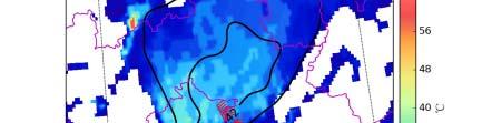
14 Locations of severe convective weather 6.23 BT IR1 (Colors), BT WV -BT IR1 (Contour lines), Short-time heavy rainfall ( 20mm/h----Blue + ; 50mm/h----Red + ; 80mm/h----Magenta + )


,")
,")

 and")
")


")

15 Locations of severe convective weather 6.23 BT IR1 (Colors), NVIS(Contour lines), Short-time heavy rainfall (+), hail(red triangle) and high wind(blue wind shaft) 11:00 12:00 13:30 11:00 12:00 13:30 In the case with strong wind shear, the locations of convective weather are g, close to cloud tops (Low BT IR1 ) and thick clouds (High NVIS) in initial stage of convection.


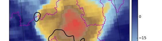


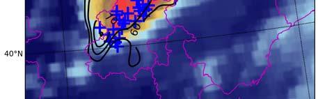


16 Locations of severe convective weather 6.23 BT IR1 (Colors), NVIS(Contour lines), Short-time heavy rainfall (+), hail(red triangle) and high wind(blue wind shaft) 15:30 16:30 17:00 15:30 16:30 17:00 Gradually, cloud tops (Low BT IR1 ) move to the downwind of thick cloud (High y, p ( IR1) ( g NVIS) because of the slantwise development of convection, and convective weather occurs near the thick cloud.


.")
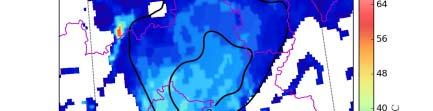
17 Locations of severe convective weather :30 13:30 14:30 15:30 In the case with weak vertical wind shear, which means the convection nearly In the case with weak vertical wind shear, which means the convection nearly develop vertically. Convective weather happens nearby the highest cloud tops (Low BT IR1 ) and the thickest clouds (High NVIS).


18


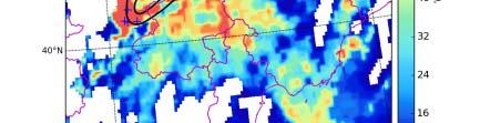
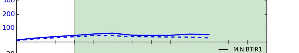
19 Intensity of short-time heavy rainfall The intensity of short-time rainfall has poor relationship with BT IR1, The e te s ty o s o t t e a a as poo e at o s p t IR1, e minimum MIRRef of the entire cloud is used to measure the particle size of cloud top, and the heavier short-time rainfall, the smaller MIRRef.
20 Intensity of short-time heavy rainfall m/h) INFALL(mm 1H RAI MIN MIRRef(%)


21 Intensity of short-time heavy rainfall Cloud Water Content Index
22 Intensity of short-time heavy rainfall m/h) INFALL(mm 1H RAI
23 Summary Five parameters are calculated or retrieved from FY2E data, including BT IR1, BT IR1 -BT WV, NVIS, MIRRef and CWCI, to measured height, thickness, particle size and water content of clouds separately. The convective clouds with large VIS and COT also have coldest BT IR1 and BT IR1 -BT WV in some cases with weak 0~6km vertical wind shear, which means the convection nearly develop vertically. In these cases convective weather happens nearby the highest cloud tops and the thickest clouds. I th ith t i d h th l ti f ti In other cases with strong wind shear, the location of convective weather is also close to cloud tops and thick clouds in initial stage of convection. But cloud tops move to the downwind of thick cloud gradually, because of the slantwise development of convection, and convective weather occurs between them.
24 Summary The minimum IR4Ref of the entire cloud is used to measure the particle size of cloud top, and the heavier short-time rainfall, the smaller MIRRef. CWCI shows that the intensity of short-time rainfall has good relationship with the cloud water content, instead of the height of cloud top.
25 FUTURE Data processing methodology NVIS: Other normalization methods CWCI MIRRef More cases study and statistics research FY2F 6-min rapid scan data FY4: 14 channels
26
A Time Lag Model to Estimate Rainfall Rate Based on GOES Data
 A Time Lag Model to Estimate Rainfall Rate Based on GOES Data Nazario D. Ramirez, Robert J. Kuligowski, and Joan M. Castro Octava Reunión Nacional de Percepción Remota y Sistemas Geográficos de Información
Applications of future GEO advanced IR sounder for high impact weather forecasting demonstration with regional OSSE
 Applications of future GEO advanced IR sounder for high impact weather forecasting demonstration with regional OSSE Jun Li @, Tim Schmit &, Zhenglong Li @, Feng Zhu @*, Pei Wang @*, Agnes Lim @, and Robert
Lecture 4b: Meteorological Satellites and Instruments. Acknowledgement: Dr. S. Kidder at Colorado State Univ.
 Lecture 4b: Meteorological Satellites and Instruments Acknowledgement: Dr. S. Kidder at Colorado State Univ. US Geostationary satellites - GOES (Geostationary Operational Environmental Satellites) US
Remote Sensing in Meteorology: Satellites and Radar. AT 351 Lab 10 April 2, Remote Sensing
 Remote Sensing in Meteorology: Satellites and Radar AT 351 Lab 10 April 2, 2008 Remote Sensing Remote sensing is gathering information about something without being in physical contact with it typically
Lecture 19: Operational Remote Sensing in Visible, IR, and Microwave Channels
 MET 4994 Remote Sensing: Radar and Satellite Meteorology MET 5994 Remote Sensing in Meteorology Lecture 19: Operational Remote Sensing in Visible, IR, and Microwave Channels Before you use data from any
CLOUD MOTION WINDS FROM FY-2 AND GMS-5 METEOROLOGICAL SATELLITES. Xu Jianmin, Zhang Qisong, Fang Xiang, Liu Jian
 CLOUD MOTION WINDS FROM FY-2 AND GMS-5 METEOROLOGICAL SATELLITES Xu Jianmin, Zhang Qisong, Fang Xiang, Liu Jian National Satellite Meteorological Center Abstract Cloud Motion Winds (CMW) from FY-2 and
Preparation for FY-4A. (Submitted by Xiang Fang, CMA)
") WORLD METEOROLOGICAL ORGANIZATION COMMISSION FOR BASIC SYSTEMS OPEN PROGRAMME AREA GROUP ON INTEGRATED OBSERVING SYSTEMS EXPERT TEAM ON SATELLITE UTILIZATION AND PRODUCTS ET-SUP-8/Doc. 10.3 (2.IV.2014)
WORLD METEOROLOGICAL ORGANIZATION COMMISSION FOR BASIC SYSTEMS OPEN PROGRAMME AREA GROUP ON INTEGRATED OBSERVING SYSTEMS EXPERT TEAM ON SATELLITE UTILIZATION AND PRODUCTS ET-SUP-8/Doc. 10.3 (2.IV.2014)
THE FEASIBILITY OF EXTRACTING LOWLEVEL WIND BY TRACING LOW LEVEL MOISTURE OBSERVED IN IR IMAGERY OVER CLOUD FREE OCEAN AREA IN THE TROPICS
 THE FEASIBILITY OF EXTRACTING LOWLEVEL WIND BY TRACING LOW LEVEL MOISTURE OBSERVED IN IR IMAGERY OVER CLOUD FREE OCEAN AREA IN THE TROPICS Toshiro Ihoue and Tetsuo Nakazawa Meteorological Research Institute
SATELLITE SIGNATURES ASSOCIATED WITH SIGNIFICANT CONVECTIVELY-INDUCED TURBULENCE EVENTS
 SATELLITE SIGNATURES ASSOCIATED WITH SIGNIFICANT CONVECTIVELY-INDUCED TURBULENCE EVENTS Kristopher Bedka 1, Wayne Feltz 1, John Mecikalski 2, Robert Sharman 3, Annelise Lenz 1, and Jordan Gerth 1 1 Cooperative
Lecture 4: Radiation Transfer
 Lecture 4: Radiation Transfer Spectrum of radiation Stefan-Boltzmann law Selective absorption and emission Reflection and scattering Remote sensing Importance of Radiation Transfer Virtually all the exchange
Meteorological Satellite Image Interpretations, Part III. Acknowledgement: Dr. S. Kidder at Colorado State Univ.
 Meteorological Satellite Image Interpretations, Part III Acknowledgement: Dr. S. Kidder at Colorado State Univ. Dates EAS417 Topics Jan 30 Introduction & Matlab tutorial Feb 1 Satellite orbits & navigation
TWO APPLICATIONS OF IMPROVEMENTS FOR AMVS OF NSMC/CMA
 TWO APPLICATIONS OF IMPROVEMENTS FOR AMVS OF NSMC/CMA RE-NAVIGATION BASED ON FULL EARTH DISC IMAGE & CALCULATION OF RADIATION TRANSFER USING NWP DATA Zhang Xiaohu, Xu Jianmin National Satellite Meteorological
The Status Report of FY-2F
 Seventh Session of the Expert Team on Satellite Utilization and Products The Status Report of FY-2F Presented by Xiang Fang National Satellite Meteorological Center (NSMC) China Meteorological Administration
Nowcasting of Severe Weather from Satellite Images (for Southern
 Nowcasting of Severe Weather from Satellite Images (for Southern Europe) Petra Mikuš Jurković Forecasting/ nowcasting of convective storms NWP models cannot well predict the exact location and intesity
Interpretation of Polar-orbiting Satellite Observations. Atmospheric Instrumentation
 Interpretation of Polar-orbiting Satellite Observations Outline Polar-Orbiting Observations: Review of Polar-Orbiting Satellite Systems Overview of Currently Active Satellites / Sensors Overview of Sensor
Czech Hydrometeorological Institute, Na Šabatce 17, CZ Praha 4, Czech Republic. 3
 MOISTURE DETECTION ABOVE CONVECTIVE STORMS UTILIZING THE METHOD OF BRIGHTNESS TEMPERATURE DIFFERENCES BETWEEN WATER VAPOR AND IR WINDOW BANDS, BASED ON 2008 MSG RAPID SCAN SERVICE DATA Jindřich Šťástka1,2,
Day Microphysics RGB Nephanalysis in daytime. Meteorological Satellite Center, JMA
 Day Microphysics RGB Nephanalysis in daytime Meteorological Satellite Center, JMA What s Day Microphysics RGB? R : B04 (N1 0.86) Range : 0~100 [%] Gamma : 1.0 G : B07(I4 3.9) (Solar component) Range :
Maps and Remote Sensing AOSC 200 Tim Canty
 Maps and Remote Sensing AOSC 200 Tim Canty Class Web Site: http://www.atmos.umd.edu/~tcanty/aosc200 Topics for today: Weather Maps Radar Satellite Observations Lecture 04 Feb 7 2019 1 Today s Weather Map
NOWCASTING PRODUCTS BASED ON MTSAT-1R RAPID SCAN OBSERVATION. In response to CGMS Action 38.33
 CGMS-39, JMA-WP-08 Prepared by JMA Agenda Item: G.II/8 Discussed in WG II NOWCASTING PRODUCTS BASED ON MTSAT-1R RAPID SCAN OBSERVATION In response to CGMS Action 38.33 This document reports on JMA s MTSAT-1R
Evaluation of Satellite and Reanalysis Products of Downward Surface Solar Radiation over East Asia
 International Workshop on Land Use/Cover Changes and Air Pollution in Asia August 4-7th, 2015, Bogor, Indonesia Evaluation of Satellite and Reanalysis Products of Downward Surface Solar Radiation over
Advanced Satellite Remote Sensing: Microwave Remote Sensing. August 11, 2011
 Advanced Satellite Remote Sensing: Microwave Remote Sensing FIU HRSSERP Internship August 11, 2011 What can Microwave Satellites Measure? Ocean Surface Wind Speed SeaIce Concentration, Edge, and age Precipitation
Remote Sensing Observations AOSC 200 Tim Canty
 Remote Sensing Observations AOSC 200 Tim Canty Class Web Site: http://www.atmos.umd.edu/~tcanty/aosc200 Topics for today: Maps Radar Satellite Observations Lecture 04 Feb 7 2019 1 Today s Weather Map http://www.wpc.ncep.noaa.gov/sfc/namussfcwbg.gif
Judit Kerényi. OMSZ-Hungarian Meteorological Service P.O.Box 38, H-1525, Budapest Hungary Abstract
 Comparison of the precipitation products of Hydrology SAF with the Convective Rainfall Rate of Nowcasting-SAF and the Multisensor Precipitation Estimate of EUMETSAT Judit Kerényi OMSZ-Hungarian Meteorological
How to display RGB imagery by SATAID
 How to display RGB imagery by SATAID Akihiro SHIMIZU Meteorological Satellite Center (MSC), Japan Meteorological Agency (JMA) Ver. 2015110500 RGB imagery on SATAID SATAID software has a function of overlapping
Principles of Radiative Transfer Principles of Remote Sensing. Marianne König EUMETSAT
 - Principles of Radiative Transfer Principles of Remote Sensing Marianne König EUMETSAT marianne.koenig@eumetsat.int Remote Sensing All measurement processes which perform observations/measurements of
VALIDATION OF INSAT-3D DERIVED RAINFALL. (Submitted by Suman Goyal, IMD) Summary and Purpose of Document
 Summary and Purpose of Document") WORLD METEOROLOGICAL ORGANIZATION COMMISSION FOR BASIC SYSTEMS OPEN PROGRAMME AREA GROUP ON INTEGRATED OBSERVING SYSTEMS INTER-PROGRAMME EXPERT TEAM ON SATELLITE UTILIZATION AND PRODUCTS SECOND SESSION
WORLD METEOROLOGICAL ORGANIZATION COMMISSION FOR BASIC SYSTEMS OPEN PROGRAMME AREA GROUP ON INTEGRATED OBSERVING SYSTEMS INTER-PROGRAMME EXPERT TEAM ON SATELLITE UTILIZATION AND PRODUCTS SECOND SESSION
STATISTICAL ANALYSIS ON SEVERE CONVECTIVE WEATHER COMBINING SATELLITE, CONVENTIONAL OBSERVATION AND NCEP DATA
 12.12 STATISTICAL ANALYSIS ON SEVERE CONVECTIVE WEATHER COMBINING SATELLITE, CONVENTIONAL OBSERVATION AND NCEP DATA Zhu Yaping, Cheng Zhoujie, Liu Jianwen, Li Yaodong Institute of Aviation Meteorology
Introduction to Electromagnetic Radiation and Radiative Transfer
 Introduction to Electromagnetic Radiation and Radiative Transfer Temperature Dice Results Visible light, infrared (IR), ultraviolet (UV), X-rays, γ-rays, microwaves, and radio are all forms of electromagnetic
Satellite observation of atmospheric dust
 Satellite observation of atmospheric dust Taichu Y. Tanaka Meteorological Research Institute, Japan Meteorological Agency 11 April 2017, SDS WAS: Dust observation and modeling @WMO, Geneva Dust observations
Observations of Mediterranean Precipitating Systems using AMSU
 Observations of Mediterranean Precipitating Systems using AMSU Beatriz FUNATSU 1, Chantal CLAUD 1 and Jean-Pierre CHABOUREAU 2 1 Laboratoire de Meteorologie Dynamique/IPSL, Palaiseau 2 Laboratoire d Aerologie/CNRS-UPS,
THE ATMOSPHERIC MOTION VECTOR RETRIEVAL SCHEME FOR METEOSAT SECOND GENERATION. Kenneth Holmlund. EUMETSAT Am Kavalleriesand Darmstadt Germany
 THE ATMOSPHERIC MOTION VECTOR RETRIEVAL SCHEME FOR METEOSAT SECOND GENERATION Kenneth Holmlund EUMETSAT Am Kavalleriesand 31 64293 Darmstadt Germany ABSTRACT The advent of the Meteosat Second Generation
LARGE-SCALE WRF-SIMULATED PROXY ATMOSPHERIC PROFILE DATASETS USED TO SUPPORT GOES-R RESEARCH ACTIVITIES
 LARGE-SCALE WRF-SIMULATED PROXY ATMOSPHERIC PROFILE DATASETS USED TO SUPPORT GOES-R RESEARCH ACTIVITIES Jason Otkin, Hung-Lung Huang, Tom Greenwald, Erik Olson, and Justin Sieglaff Cooperative Institute
Update on SCOPE-Nowcasting Pilot Project Real Time Ocean Products Suman Goyal Scientist-E
 Update on SCOPE-Nowcasting Pilot Project Real Time Ocean Products Suman Goyal Scientist-E 19-22 Nov 2013 SCOPE-Nowcasting-1 Agenda Item 5 Pilot Projects Overview Users /Clients User requirements Product
JMA s ATMOSPHERIC MOTION VECTORS In response to Action 40.22
 5 July 2013 Prepared by JMA Agenda Item: II/6 Discussed in WG II JMA s ATMOSPHERIC MOTION VECTORS In response to Action 40.22 This paper reports on the recent status of JMA's AMVs from MTSAT-2 and MTSAT-1R,
Hail nowcast exploiting radar and satellite observations
 Federal Department of Home Affairs FDHA Federal Office of Meteorology and Climatology MeteoSwiss Hail nowcast exploiting radar and satellite observations Ulrich Hamann, Elena Leonarduzzi, Kristopher Bedka,
Instrument Calibration Issues: Geostationary Platforms
 Instrument Calibration Issues: Geostationary Platforms Ken Holmlund EUMETSAT kenneth.holmlund@eumetsat.int Abstract The main products derived from geostationary satellite data and used in Numerical Weather
F O U N D A T I O N A L C O U R S E
 F O U N D A T I O N A L C O U R S E December 6, 2018 Satellite Foundational Course for JPSS (SatFC-J) F O U N D A T I O N A L C O U R S E Introduction to Microwave Remote Sensing (with a focus on passive
A statistical approach for rainfall confidence estimation using MSG-SEVIRI observations
 A statistical approach for rainfall confidence estimation using MSG-SEVIRI observations Elisabetta Ricciardelli*, Filomena Romano*, Nico Cimini*, Frank Silvio Marzano, Vincenzo Cuomo* *Institute of Methodologies
Remote Sensing Seminar 8 June 2007 Benevento, Italy. Lab 5 SEVIRI and MODIS Clouds and Fires
 Remote Sensing Seminar 8 June 2007 Benevento, Italy Lab 5 SEVIRI and MODIS Clouds and Fires Table: SEVIRI Channel Number, Wavelength (µm), and Primary Application Reflective Bands 1,2 0.635, 0.81 land/cld
SAN FRANCISCO STATE UNIVERSITY NAME DEPARTMENT OF GEOSCIENCES Spring 2013
 SAN FRANCISCO STATE UNIVERSITY NAME DEPARTMENT OF GEOSCIENCES Spring 2013 METR 415/715: MONTEVERDI QUIZ 1 Open Book and Open Notes 200 points, 45 minutes 1. Compute the altitude of a geostationary orbit
Satellite-based Convection Nowcasting and Aviation Turbulence Applications
 Satellite-based Convection Nowcasting and Aviation Turbulence Applications Kristopher Bedka Cooperative Institute for Meteorological Satellite Studies (CIMSS), University of Wisconsin-Madison In collaboration
Synergetic Use of GPS Water Vapor and Meteosat Images for Synoptic Weather Forecasting
 514 JOURNAL OF APPLIED METEOROLOGY Synergetic Use of GPS Water Vapor and Meteosat Images for Synoptic Weather Forecasting SIEBREN DE HAAN, SYLVIA BARLAG, HENK KLEIN BALTINK, AND FRANS DEBIE KNMI, De Bilt,
Assessment of AHI Level-1 Data for HWRF Assimilation
 Assessment of AHI Level-1 Data for HWRF Assimilation Xiaolei Zou 1 and Fuzhong Weng 2 1 Earth System Science Interdisciplinary Center, University of Maryland, College Park, Maryland 2 Satellite Meteorology
CLOUD CLASSIFICATION AND CLOUD PROPERTY RETRIEVAL FROM MODIS AND AIRS
 6.4 CLOUD CLASSIFICATION AND CLOUD PROPERTY RETRIEVAL FROM MODIS AND AIRS Jun Li *, W. Paul Menzel @, Timothy, J. Schmit @, Zhenglong Li *, and James Gurka # *Cooperative Institute for Meteorological Satellite
Temperature AOSC 200 Tim Canty
 Temperature AOSC 200 Tim Canty Class Web Site: http://www.atmos.umd.edu/~tcanty/aosc200 Topics for today: Daily Temperatures Role of clouds, latitude, land/water Lecture 09 Feb 26 2019 1 Today s Weather
Severe storms over the Mediterranean Sea: A satellite and model analysis
 National Research Council of Italy Severe storms over the Mediterranean Sea: A satellite and model analysis V. Levizzani, S. Laviola, A. Malvaldi, M. M. Miglietta, and E. Cattani 6 th International Precipitation
CTTH Cloud Top Temperature and Height
 CTTH Cloud Top Temperature and Height 15 th June 2004 Madrid Hervé Le Gléau and Marcel Derrien Météo-France / CMS lannion 1 Plan of CTTH presentation Algorithms short description Some examples Planned
Aviation Hazards: Thunderstorms and Deep Convection
 Aviation Hazards: Thunderstorms and Deep Convection TREND Diagnosis of thunderstorm hazards using imagery Contents Satellite imagery Visible, infrared, water vapour Basic cloud identification Identifying
Updates on Chinese Meteorological Satellite Programs
 6 th Asia/Oceania Meteorological Satellite Users Conference Updates on Chinese Meteorological Satellite Programs Caiying Wei Deputy director-general of NSMC National Satellite Meteorological Center (NSMC)
Tracer quality identifiers for accurate Cloud Motion Wind
 Abstract for the Workshop on Wind extraction from operational Meteorological Satellite data Washington DC, 17-19 September 1991 Tracer quality identifiers for accurate Cloud Motion Wind estimates Kenneth
MSGVIEW: AN OPERATIONAL AND TRAINING TOOL TO PROCESS, ANALYZE AND VISUALIZATION OF MSG SEVIRI DATA
 MSGVIEW: AN OPERATIONAL AND TRAINING TOOL TO PROCESS, ANALYZE AND VISUALIZATION OF MSG SEVIRI DATA Aydın Gürol Ertürk Turkish State Meteorological Service, Remote Sensing Division, CC 401, Kalaba Ankara,
JMA s atmospheric motion vectors
 Prepared by JMA Agenda Item: WG II/6 Discussed in WG II JMA s atmospheric motion vectors This paper reports on the recent status of JMA's Atmospheric Motion Vectors (AMVs) from MTSAT-2 and MTSAT-1R, and
Remote Sensing of Precipitation
 Lecture Notes Prepared by Prof. J. Francis Spring 2003 Remote Sensing of Precipitation Primary reference: Chapter 9 of KVH I. Motivation -- why do we need to measure precipitation with remote sensing instruments?
MSG system over view
 MSG system over view 1 Introduction METEOSAT SECOND GENERATION Overview 2 MSG Missions and Services 3 The SEVIRI Instrument 4 The MSG Ground Segment 5 SAF Network 6 Conclusions METEOSAT SECOND GENERATION
McIDAS support of Suomi-NPP /JPSS and GOES-R L2
 McIDAS support of Suomi-NPP /JPSS and GOES-R L2 William Straka III 1 Tommy Jasmin 1, Bob Carp 1 1 Cooperative Institute for Meteorological Satellite Studies, Space Science and Engineering Center, University
Satellite remote sensing of aerosols & clouds: An introduction
 Satellite remote sensing of aerosols & clouds: An introduction Jun Wang & Kelly Chance April 27, 2006 junwang@fas.harvard.edu Outline Principals in retrieval of aerosols Principals in retrieval of water
Outgoing long wave radiation (OLR) a proxy of convection
 a proxy of convection") Outgoing long wave radiation (OLR) a proxy of convection Vijay Garg M.M.College, Modinagar, Ghaziabad Abstract: Outgoing long wave radiation (OLR) is a proxy indicator of convection. It is measured through
Outgoing long wave radiation (OLR) a proxy of convection Vijay Garg M.M.College, Modinagar, Ghaziabad Abstract: Outgoing long wave radiation (OLR) is a proxy indicator of convection. It is measured through
AOSC201: Weather and Climate Lab
 AOSC201: Weather and Climate Lab Week 8: Forecasting - Analysis Section 107/108 Instructor: Agniv Sengupta q Lab #7 of Lab Manual (pages 41-49) q 50 points in total q INDIVIDUAL Work for the entire lab
METEOSAT cloud-cleared radiances for use in three/fourdimensional variational data assimilation
 METEOSAT cloud-cleared radiances for use in three/fourdimensional variational data assimilation G. A. Kelly, M. Tomassini and M. Matricardi European Centre for Medium-Range Weather Forecasts, Reading,
6A.4 REFLECTIVE STORM TOPS: A SATELLITE METHOD FOR INFERRING THUNDERSTORM TOP MICROPHYSICAL STRUCTURE. Fort Collins, Colorado. Fort Collins, Colorado
 6A.4 REFLECTIVE STORM TOPS: A SATELLITE METHOD FOR INFERRING THUNDERSTORM TOP MICROPHYSICAL STRUCTURE Daniel T. Lindsey 1* and Louie Grasso 2 1 NOAA/NESDIS/ORA/RAMMB Fort Collins, Colorado 2 Cooperative
Satellites, Weather and Climate Module 1: Introduction to the Electromagnetic Spectrum
 Satellites, Weather and Climate Module 1: Introduction to the Electromagnetic Spectrum What is remote sensing? = science & art of obtaining information through data analysis, such that the device is not
The water vapour channels of SEVIRI (Meteosat). An introduction
. An introduction") The water vapour channels of SEVIRI (Meteosat). An introduction jose.prieto@eumetsat.int Cachoeira P. July 2006 Formats 1.5 1 Objectives 2 Describe the characteristics of WV channels on board of SEVIRI
The water vapour channels of SEVIRI (Meteosat). An introduction jose.prieto@eumetsat.int Cachoeira P. July 2006 Formats 1.5 1 Objectives 2 Describe the characteristics of WV channels on board of SEVIRI
NEW SCHEME TO IMPROVE THE DETECTION OF RAINY CLOUDS IN PUERTO RICO
 NEW SCHEME TO IMPROVE THE DETECTION OF RAINY CLOUDS IN PUERTO RICO Joan Manuel Castro Sánchez Advisor Dr. Nazario Ramirez UPRM NOAA CREST PRYSIG 2016 October 7, 2016 Introduction A cloud rainfall event
Lecture 4: Heat, and Radiation
 Lecture 4: Heat, and Radiation Heat Heat is a transfer of energy from one object to another. Heat makes things warmer. Heat is measured in units called calories. A calorie is the heat (energy) required
On the Satellite Determination of Multilayered Multiphase Cloud Properties. Science Systems and Applications, Inc., Hampton, Virginia 2
 JP1.10 On the Satellite Determination of Multilayered Multiphase Cloud Properties Fu-Lung Chang 1 *, Patrick Minnis 2, Sunny Sun-Mack 1, Louis Nguyen 1, Yan Chen 2 1 Science Systems and Applications, Inc.,
REPORT ON THE ACTIVITIES OF THE EUMETSAT-ESSL CONVECTION WORKING GROUP
 REPORT ON THE ACTIVITIES OF THE EUMETSAT-ESSL CONVECTION WORKING GROUP Marianne König EUMETSAT, Eumetsat Allee 1, 64295 Darmstadt, Germany Abstract The focus of the Convection Working Group is to have
INTERPRETATION GUIDE TO MSG WATER VAPOUR CHANNELS
 INTERPRETATION GUIDE TO MSG WATER VAPOUR CHANNELS C.G. Georgiev1 and P. Santurette2 1 National Institute of Meteorology and Hydrology, Tsarigradsko chaussee 66, 1784 Sofia, Bulgaria 2 Météo-France, 42,
CMA Consideration on early-morning orbit satellite
 CMA Consideration on early-morning orbit satellite National Satellite Meteorological Center,CMA Yang Jun CGMS 40 in Lugano, 5-9 Nov., 2012 Outline Background Gap analysis on the sounding data coverage
RECENT ADVANCES TO EXPERIMENTAL GMS ATMOSPHERIC MOTION VECTOR PROCESSING SYSTEM AT MSC/JMA
 RECENT ADVANCES TO EXPERIMENTAL GMS ATMOSPHERIC MOTION VECTOR PROCESSING SYSTEM AT MSC/JMA Ryoji Kumabe 1, Yoshiki Kajino 1 and Masami Tokuno 2 1 Meteorological Satellite Center, Japan Meteorological Agency
Sensitivity Study of the MODIS Cloud Top Property
 Sensitivity Study of the MODIS Cloud Top Property Algorithm to CO 2 Spectral Response Functions Hong Zhang a*, Richard Frey a and Paul Menzel b a Cooperative Institute for Meteorological Satellite Studies,
Derivation of AMVs from single-level retrieved MTG-IRS moisture fields
 Derivation of AMVs from single-level retrieved MTG-IRS moisture fields Laura Stewart MetOffice Reading, Meteorology Building, University of Reading, Reading, RG6 6BB Abstract The potential to derive AMVs
Operational Uses of Bands on the GOES-R Advanced Baseline Imager (ABI) Presented by: Kaba Bah
 Presented by: Kaba Bah") Operational Uses of Bands on the GOES-R Advanced Baseline Imager (ABI) Presented by: Kaba Bah Topics: Introduction to GOES-R & ABI ABI individual bands Use of band differences ABI derived products Conclusions
Operational Uses of Bands on the GOES-R Advanced Baseline Imager (ABI) Presented by: Kaba Bah Topics: Introduction to GOES-R & ABI ABI individual bands Use of band differences ABI derived products Conclusions
SATELLITE MONITORING OF THE CONVECTIVE STORMS
 SATELLITE MONITORING OF THE CONVECTIVE STORMS FORECASTERS POINT OF VIEW Michaela Valachová, EUMETSAT Workshop at ECMWF User Meeting Reading, 13 June 2017 Central Forecasting Office, Prague michaela.valachova@chmi.cz
APPLICATIONS WITH METEOROLOGICAL SATELLITES. W. Paul Menzel. Office of Research and Applications NOAA/NESDIS University of Wisconsin Madison, WI
 APPLICATIONS WITH METEOROLOGICAL SATELLITES by W. Paul Menzel Office of Research and Applications NOAA/NESDIS University of Wisconsin Madison, WI July 2004 Unpublished Work Copyright Pending TABLE OF CONTENTS
P2.12 Sampling Errors of Climate Monitoring Constellations
 P2.12 Sampling Errors of Climate Monitoring Constellations Renu Joseph 1*, Daniel B. Kirk-Davidoff 1 and James G. Anderson 2 1 University of Maryland, College Park, Maryland, 2 Harvard University, Cambridge,
Rapidly Developing Thunderstorm (RDT)
") Rapidly Developing Thunderstorm (RDT) Jean-Marc Moisselin, Frédéric Autones Météo-France Nowcasting Department 42, av. Gaspard Coriolis 31057 Toulouse France jean-marc.moisselin@meteo.fr EUMETRAIN Convection
Rapidly Developing Thunderstorm (RDT) Jean-Marc Moisselin, Frédéric Autones Météo-France Nowcasting Department 42, av. Gaspard Coriolis 31057 Toulouse France jean-marc.moisselin@meteo.fr EUMETRAIN Convection
QUALITY OF MPEF DIVERGENCE PRODUCT AS A TOOL FOR VERY SHORT RANGE FORECASTING OF CONVECTION
 QUALITY OF MPEF DIVERGENCE PRODUCT AS A TOOL FOR VERY SHORT RANGE FORECASTING OF CONVECTION C.G. Georgiev 1, P. Santurette 2 1 National Institute of Meteorology and Hydrology, Bulgarian Academy of Sciences
Figure 1: Tephigram for radiosonde launched from Bath at 1100 UTC on 15 June 2005 (IOP 1). The CAPE and CIN are shaded dark and light gray,
. The CAPE and CIN are shaded dark and light gray,") Figure 1: Tephigram for radiosonde launched from Bath at 1100 UTC on 1 June 200 (IOP 1). The CAPE and CIN are shaded dark and light gray, respectively; the thin solid line partially bounding these areas
Figure 1: Tephigram for radiosonde launched from Bath at 1100 UTC on 1 June 200 (IOP 1). The CAPE and CIN are shaded dark and light gray, respectively; the thin solid line partially bounding these areas
LAND SURFACE TEMPERATURE VALIDATION WITH IN SITU MEASUREMENTS
 LAND SURFACE TEMPERATURE VALIDATION WITH IN SITU MEASUREMENTS Group 7 Juan Manuel González Cantero Irene Grimaret Rincón Alex Webb Advisor: Darren Ghent Research problem The project task is to design an
The MODIS Cloud Data Record
 The MODIS Cloud Data Record Brent C. Maddux 1,2 Steve Platnick 3, Steven A. Ackerman 1 Paul Menzel 1, Kathy Strabala 1, Richard Frey 1, 1 Cooperative Institute for Meteorological Satellite Studies, 2 Department
USE, QUALITY CONTROL AND MONITORING OF SATELLITE WINDS AT UKMO. Pauline Butterworth. Meteorological Office, London Rd, Bracknell RG12 2SZ, UK ABSTRACT
 USE, QUALITY CONTROL AND MONITORING OF SATELLITE WINDS AT UKMO Pauline Butterworth Meteorological Office, London Rd, Bracknell RG12 2SZ, UK ABSTRACT Satellite wind fields derived from geostationary imagery
Spectrum of Radiation. Importance of Radiation Transfer. Radiation Intensity and Wavelength. Lecture 3: Atmospheric Radiative Transfer and Climate
 Lecture 3: Atmospheric Radiative Transfer and Climate Radiation Intensity and Wavelength frequency Planck s constant Solar and infrared radiation selective absorption and emission Selective absorption
Radiative Transfer Model based Bias Correction in INSAT-3D/3DR Thermal Observations to Improve Sea Surface Temperature Retrieval
 Radiative Transfer Model based Bias Correction in INSAT-3D/3DR Thermal Observations to Improve Sea Surface Temperature Retrieval Rishi K Gangwar, Buddhi P Jangid, and Pradeep K Thapliyal Space Applications
Current status and plans of JMA operational wind product
 Current status and plans of JMA operational wind product Kazuki Shimoji Japan Meteorological Agency / Meteorological Satellite Center 3-235, Nakakiyoto, Kiyose, Tokyo, Japan Abstract The Meteorological
STATUS OF JAPANESE METEOROLOGICAL SATELLITES AND RECENT ACTIVITIES OF MSC
 STATUS OF JAPANESE METEOROLOGICAL SATELLITES AND RECENT ACTIVITIES OF MSC Daisaku Uesawa Meteorological Satellite Center, Japan Meteorological Agency Abstract MTSAT-1R is the current operational Japanese
Status report on the current and future satellite systems by CMA. Presented to CGMS46-CMA-WP-01, Plenary session, agenda item D.1
 Status report on the current and future satellite systems by CMA Presented to CGMS46-CMA-WP-01, Plenary session, agenda item D.1 Overview - Planning of CMA satellite systems FengYun Meteorological Satellites
GEOMETRIC CLOUD HEIGHTS FROM METEOSAT AND AVHRR. G. Garrett Campbell 1 and Kenneth Holmlund 2
 GEOMETRIC CLOUD HEIGHTS FROM METEOSAT AND AVHRR G. Garrett Campbell 1 and Kenneth Holmlund 2 1 Cooperative Institute for Research in the Atmosphere Colorado State University 2 EUMETSAT ABSTRACT Geometric
Lecture 3: Atmospheric Radiative Transfer and Climate
 Lecture 3: Atmospheric Radiative Transfer and Climate Solar and infrared radiation selective absorption and emission Selective absorption and emission Cloud and radiation Radiative-convective equilibrium
TWO APPLICATIONS OF IMPROVEMENTS FOR AMVS OF NSMC/CMA. Zhang Xiaohu, Xu Jianmin National Satellite Meteorological Center, Beijing , CHINA
 TWO APPLICATIONS OF IMPROVEMENTS FOR AMVS OF NSMC/CMA Zhang Xiaohu, Xu Jianmin National Satellite Meteorological Center, Beijing 100081, CHINA RE-NAVIGATION BASED ON FULL EARTH DISC IMAGE CALCULATION OF
Satellite and Aircraft Observations of Snowfall Signature at Microwave Frequencies. Yoo-Jeong Noh and Guosheng Liu
 Satellite and Aircraft Observations of Snowfall Signature at Microwave Frequencies Yoo-Jeong Noh and Guosheng Liu Department of Meteorology, Florida State University Tallahassee, Florida, USA Corresponding
RETRIEVAL AND APPLICATIONS OF ATMOSPHERIC MOTION VECTORS USING INSAT-3D/3DR DATA : ISRO STATUS
 RETRIEVAL AND APPLICATIONS OF ATMOSPHERIC MOTION VECTORS USING INSAT-3D/3DR DATA : ISRO STATUS Sanjib K Deb, D K Sankhala, C M Kishtawal Atmospheric and Oceanic Sciences Group Space Applications Centre
OVERSHOOTING TOPS CHARACTERISTICS AND PROPERTIES
 OVERSHOOTING TOPS CHARACTERISTICS AND PROPERTIES Michaela Valachová 1,2, Martin Setvák 2, Jindřich Šťástka 1,2 1 Charles University in Prague, Faculty of Mathematics and Physics, Department of Meteorology
Lecture # 04 January 27, 2010, Wednesday Energy & Radiation
 Lecture # 04 January 27, 2010, Wednesday Energy & Radiation Kinds of energy Energy transfer mechanisms Radiation: electromagnetic spectrum, properties & principles Solar constant Atmospheric influence
Lecture 4: Meteorological Satellites and Instruments. Acknowledgement: Dr. S. Kidder at Colorado State Univ.
 Lecture 4: Meteorological Satellites and Instruments Acknowledgement: Dr. S. Kidder at Colorado State Univ. Homework for the Spring Break: get some tangible, preliminary results for your final project.
Feature-tracked 3D Winds from Satellite Sounders: Derivation and Impact in Global Models
 Feature-tracked 3D Winds from Satellite Sounders: Derivation and Impact in Global Models David Santek 1, A.-S. Daloz 1, S. Tushaus 1, M. Rogal 1, W. McCarty 2 1 Space Science and Engineering Center/University
CHARACTERISTICS OF EMBEDDED WARM AREAS AND SURROUNDING COLD RINGS AND COLD-US
 CHARACTERISTICS OF EMBEDDED WARM AREAS AND SURROUNDING COLD RINGS AND COLD-US Michaela Radová 1,2, Jindřich Šťástka 1,2, Jakub Seidl 3 (1) Department of Meteorology and Environment Protection, Faculty
Very Dynamic! Energy in the Earth s Atmosphere. How Does it Get Here? All Objects Radiate Energy!
 Energy in the Earth s Atmosphere Unit Essential Question: What are the different features of the atmosphere that characterize our weather. How does the atmosphere influence life and how does life influence
Atmospheric Motion Vectors (AMVs) and their forecasting significance
 and their forecasting significance") Atmospheric Motion Vectors (AMVs) and their forecasting significance Vijay Garg M.M. College, Modi Nagar, Ghaziabad, Uttar Pradesh R.K. Giri Meteorological Center India Meteorological Department, Patna-14
Atmospheric Motion Vectors (AMVs) and their forecasting significance Vijay Garg M.M. College, Modi Nagar, Ghaziabad, Uttar Pradesh R.K. Giri Meteorological Center India Meteorological Department, Patna-14
IMPACTS OF SPATIAL OBSERVATION ERROR CORRELATION IN ATMOSPHERIC MOTION VECTORS ON DATA ASSIMILATION
 Proceedings for the 13 th International Winds Workshop 27 June - 1 July 2016, Monterey, California, USA IMPACTS OF SPATIAL OBSERVATION ERROR CORRELATION IN ATMOSPHERIC MOTION VECTORS ON DATA ASSIMILATION
Meteorological product extraction: Making use of MSG imagery
 Meteorological product extraction: Making use of MSG imagery Kenneth Holmlund, Simon Elliott, Leo van de Berg, Stephen Tjemkes* Meteorological Operations Division *Meteorological Division EUMETSAT Am Kavalleriesand