Rapidly Developing Cumulus Area RDCA detection using Himawari-8 data
|
|
|
- Clyde Bradford
- 5 years ago
- Views:
Transcription
1 Rapidly Developing Cumulus Area RDCA detection using Himawari-8 data Hiroshi SUZUE and Yasuhiko SUMIDA Meteorological Satellite Center Japan Meteorological Agency
2 Contents Ø Outline of Himawari-8/9 ü Improved Resolutions ü Advantages of High Observation Frequency Ø Detection of Rapidly Developing Cumulus Area ü Algorithm ü Validation ü Case Study Ø Future Plan Ø Summary 2
3 Himawari-8 began operation at 02:00 UTC on 7th July
 Raw observation data transmission Ka-band, 18.1-18.4 GHz (downlink) 2) DCS International channel 402.0-402.")
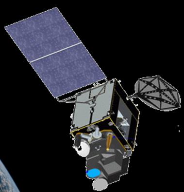
4 Outline of Himawari-8/9 Advanced Himawari Imager (AHI) solar panel communication antennas Geostationary position Attitude control Communication Around E 3-axis attitude-controlled geostationary satellite 1) Raw observation data transmission Ka-band, GHz (downlink) 2) DCS International channel MHz (uplink) Domestic channel MHz (uplink) Transmission to ground segments Ka-band, GHz (downlink) 3) Telemetry and command Ku-band, GHz (downlink) GHz (uplink) Himawari-8 began operation on 7 July 2015, replacing the previous MTSAT-2 operational satellite MTSAT-1R MTSAT-2 operation standby standby operation standby Himawari-8 Himawari-9 a package purchase manufacture manufacture launch launch operation standby standby operation standby 4
5 MSC/JMA Improved Resolutions Spatial At sub-satellite point VIS 1 km IR 4 km VIS 0.5/1 km IR 2 km MTSAT-1R/2 Himawari-8/9 Spectral VIS 1 band 3 bands VIS R G B Temporal NIR 3 bands Observation Frequency IR 4 bands IR 10 bands full-disk obs. MTSAT-1R/2 Himawari-8/9 5 bands 16 bands MTSAT-1R/2 Himawari-8/9 5


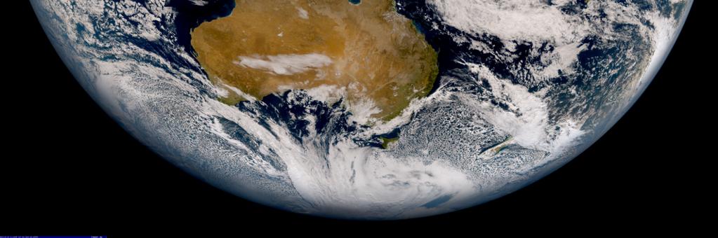
6 Observation modes and intervals Visible band True Color RGB July 9-10, 2015 Japan & Vicinity Obs. 2.5 min. Targeted Area obs. 2.5 min. Full Disk Obs. 10 min. Visible band 6
 heavy rain")

 [traced and added] 3min 3min If we")

7 Developing Cumulus and Radar Echo height Developing of Cumulus (model) heavy rain area of Met. Radar 0 min 10 min 15 min 20 min 25 min 30 min time Chisholm, A. J. and Renick, J. H. (1972) [traced and added] 3min 3min If we can detect cumulus that is growing rapidly, we get to know thunderstorm coming earlier than the radar! Prepare for thunderstorm! 7


8 MSC/JMA RDCA Product Convective Cloud Information Cumulonimbus Rapidly Developing Cumulus Mid/Low cloud unknown 8

9 l Rapidly Developing Cumulus Area (RDCA) ü Developing cumulous ü Current/Future disturbance is expected RDCA Product Rapidly Developing Cumulus Area Cumulonimbus Area Mid/Low cloud unknown Area l Cumulonimbus Area ü A round top, except for anvil cirrus ü Strong upward flow is expected? l Mid/Low Cloud Unknown Area ü Anvil cirrus ü Anvil cirrus hides clouds below 9
10 Concept of RDCA Detection Cloud Height After 5 min. Cloud top adjacent Developing cumulus Cloud top is higher Brightness temperature is getting low. Roughness of cloud top increases Contrast between light and dark is getting clear. e.g. Difference of reflective intensity is increasing in visible image. Cloud microphysical parameters change Ice particles are produced near cloud top 10
11 RDCA : Decision Process Logistic Regression Model 1 p = ì æ 1+ expí- ça0 + î è å i a i x i öü ý øþ Three class parameters; :<250K, :250~273.15K, :>273.15K Probability (forecast) Detection parameters Actual Probability lightning obs. [num/area ] (13. Jul ) The correlation between lightning and regression p developing Coefficients a i are determined by the logistic regression analysis when lightning occurs within 1 hour after observed variable x i. => High P area is decided as RDCA Predicted Probability p 11
12 Ø RDCA detection parameters Only day time New Only day time New No. Detection Parameter Main Objective 1 B03(0.64um):Max-Ave.* 2 Cloud Top Roughness Detection 2 B03:Standad Deviation* 2 Cloud Top Roughness Detection 3 B13(10.4um):Min.-Ave. Cloud Top Roughness Detection 4 B13:Standard Deviation Cloud Top Roughness Detection 5 B16(13.3um)-B13 Ice Cloud Detection 6 B08(6.2um)-B13 Water Vapor Detection above Cloud Top 9 B15(12.4um)-B13 Ice Cloud Detection Water Vapor Detection above 10 B10(7.3um)-B08 Cloud Top 11 B11(8.6um)-B13 Ice Cloud Detection Temporal Variation of Presumption of Developing 21 B03 Average Value* 2 Level of Cloud Temporal Variation of Presumption of Developing 23 B13 Average Value Level of Cloud Temporal Variation of Developing Ice Particle 24 B11-B13 Average Value* Detection Temporal Variation of Developing Ice Particle 25 B15-B13 Average Value* Detection One Scene Parameters Time Change Parameters 12
 3 24 28 Sep. (5 days) Total: 15 days + 0.1-0.")
13 Validation of RDCA Day time (00-09UTC) / Night time (12-21UTC) Truth:lightning (CC and CG) detection Validation Period July (5 days) 2 28 Aug. 1 Sep. (5 days) Sep. (5 days) Total: 15 days Hit Range Hit 0 +1 h time Lightning detection number Mutch Up Validation 13
14 Validation of RDCA Old Algorithm Year Time Zone Satellite Period POD [%] FAR [%] 2012 Daytime MTSAT-1R Jun. Sep Daytime MTSAT-1R Jun. Sep Daytime MTSAT-1R Jun. Sep Daytime Himawari-8 Jun. Sep Summer in 2015 Method Time Zone Satellite Period POD [%] FAR [%] Old Daytime Himawari-8 15 days New Daytime Himawari-8 15 days New Nighttime Himawari-8 15 days


15 MSC/JMA Case Study #1 Ø Early detection of convective cloud with lightning RDCA product can detect developing cumulus earlier than a radar echo UTC RDCA Detection UTC Radar Echo Detection UTC Lightning Detection On 4 Aug


16 MSC/JMA Case Study #2 Ø False detection due to passing upper clouds Brightness temperature seems to decrease rapidly because upper clouds pass over lower clouds UTC UTC UTC UTC On 6 June


17 MSC/JMA Future Plan Ø Domain extension of the RDCA product using Himawari-8/AHI Full Disk observation data for safety and air traffic control over Asia and Western Pacific regions Sample Animation Sample of extended domain RDCA product 17


18 MSC/JMA Future Plan Ø Improvement of the RDCA detection algorithm (e.g. cloud tracking) Sample Animation Sample of cloud object tracking 18
19 Summary Ø Improved Observation Function by Himawari-8/AHI ü High-resolution and high-frequency observation using multiple bands enables to capture server weather phenomena Ø Detection of Rapidly Developing Cumulus Area ü Statistical method is used for rapidly developing cumulus detection ü RDCA product has been operational all day using multiple observation bands data ü POD and FAR are about 60 % Ø Future Plan ü Domain extension of the RDCA product ü Improvement of the RDCA detection algorithm 19

20 Thank you for your kind attention JMA mascot character Harerun 20
Overview of Himawari-8/9
 Overview of Himawari-8/9 Toshiyuki SAKURAI Meteorological Satellite Center (MSC) Japan Meteorological Agency (JMA) EUMeTrain Event Week on MTG-I Satellite 2016 Session2 - Himawari-8 and Data Applications
4.1 New Generation Satellite Data and Nowcasting Products: Himawari
 4.1 New Generation Satellite Data and Nowcasting Products: Himawari SCOPE-Nowcasting-EP 18-20 September 2017 Koji Yamashita kobo.yamashita@met.kishou.go.jp Meteorological Satellite Center (MSC) Japan Meteorological
NOWCASTING PRODUCTS BASED ON MTSAT-1R RAPID SCAN OBSERVATION. In response to CGMS Action 38.33
 CGMS-39, JMA-WP-08 Prepared by JMA Agenda Item: G.II/8 Discussed in WG II NOWCASTING PRODUCTS BASED ON MTSAT-1R RAPID SCAN OBSERVATION In response to CGMS Action 38.33 This document reports on JMA s MTSAT-1R
FUTURE PLAN AND RECENT ACTIVITIES FOR THE JAPANESE FOLLOW-ON GEOSTATIONARY METEOROLOGICAL SATELLITE HIMAWARI-8/9
 FUTURE PLAN AND RECENT ACTIVITIES FOR THE JAPANESE FOLLOW-ON GEOSTATIONARY METEOROLOGICAL SATELLITE HIMAWARI-8/9 Toshiyuki Kurino Japan Meteorological Agency, 1-3-4 Otemachi Chiyodaku, Tokyo 100-8122,
Himawari 8: Experiences and Lessons Learned. Daisaku Uesawa Meteorological Satellite Center (MSC) Japan Meteorological Agency (JMA)
 Japan Meteorological Agency (JMA)") Himawari 8: Experiences and Lessons Learned Daisaku Uesawa Meteorological Satellite Center (MSC) Japan Meteorological Agency (JMA) IPET SUP 2, GENEVA, SWITZERLAND, 23 26 FEBRUARY 2016 1 Himawari-8 operation
Himawari 8: Experiences and Lessons Learned Daisaku Uesawa Meteorological Satellite Center (MSC) Japan Meteorological Agency (JMA) IPET SUP 2, GENEVA, SWITZERLAND, 23 26 FEBRUARY 2016 1 Himawari-8 operation
Himawari 8/9 data distribution/dissemination plan
 Himawari 8/9 data distribution/dissemination plan Japan Meteorological Agency (JMA) Hidehiko MURATA Himawari is the name of this flower in Japanese ET SUP 8, WMO HQ, Geneva, 14 17 April 2014 1 Outline
Inter-comparison MTSAT-2 & Himawari-8
 Inter-comparison MTSAT-2 & Himawari-8 WMO Volcanic Ash Advisory Centre Best Practice Workshop 2017 Tokyo Volcanic Ash Advisory Centre Japan Meteorological Agency Outline Introduction Method Case study
Recent Improvement of Integrated Observation Systems in JMA
 Recent Improvement of Integrated Observation Systems in JMA Mr Osamu Suzuki and Mr Yoshihiko Tahara Japan Meteorological Agency 1-3-4 Otemachi, Chiyoda-ku, Tokyo 100-8122, Japan Tel: +81-3-3212-8341, Fax:
1. History and Current Status
 Contents 1. History and Current Status History and Mission Image acquisition and Dissemination Products 2. Future Plan Schedule Mission of Himawari 8/9 Development of Products Data Dissemination 0 1. History
Day Microphysics RGB Nephanalysis in daytime. Meteorological Satellite Center, JMA
 Day Microphysics RGB Nephanalysis in daytime Meteorological Satellite Center, JMA What s Day Microphysics RGB? R : B04 (N1 0.86) Range : 0~100 [%] Gamma : 1.0 G : B07(I4 3.9) (Solar component) Range :
Benefits of the new-generation Himawari-8 geostationary satellite for the Asia-Pacific region. Toshihiko HASHIDA Japan Meteorological Agency (JMA)
") Benefits of the new-generation Himawari-8 geostationary satellite for the Asia-Pacific region Toshihiko HASHIDA Japan Meteorological Agency (JMA) Side Event Ensuring User Readiness to New-Generation Meteorological
Benefits of the new-generation Himawari-8 geostationary satellite for the Asia-Pacific region Toshihiko HASHIDA Japan Meteorological Agency (JMA) Side Event Ensuring User Readiness to New-Generation Meteorological
Introduction to Himawari-8
 Introduction to Himawari-8 Training on meteorological satellite data usage Kotaro BESSHO Meteorological Satellite Center (MSC) Japan Meteorological Agency (JMA) The Sixth Asia/Oceania Meteorological Satellite
How to display RGB imagery by SATAID
 How to display RGB imagery by SATAID Akihiro SHIMIZU Meteorological Satellite Center (MSC), Japan Meteorological Agency (JMA) Ver. 2015110500 RGB imagery on SATAID SATAID software has a function of overlapping
Status and Plans of Next Generation Japanese Geostationary Meteorological Satellites Himawari 8/9
 Status and Plans of Next Generation Japanese Geostationary Meteorological Satellites Himawari 8/9 Masahiro Hayashi 1, Kotaro Bessho 1, and Tomoo Ohno 2 1: JMA/Meteorological Satellite Center (MSC) 2: JMA/Satellite
Ash RGB Detection of Volcanic Ash
 Copyright, JMA RGB Detection of Volcanic Meteorological Satellite Center, JMA Ver. 20150424 Volcanic Detection by Infrared and Difference Image, and Basis Himawari-8 B15-B13 2015-02-16 06:35 UTC Himawari-8
Fog detection product
 Fog detection product derived from RGB recipes Takumi Maruyama, Haruma Ishida and Koetsu Chubachi Meteorological Satellite Center / Japan Meteorological Agency Meteorological Research Institute / Japan
AOMSUC-6 Training Event
 Effective use of high temporal and spatial resolution Himawari-8 data AOMSUC-6 Training Event Bodo Zeschke Australian Bureau of Meteorology Training Centre Australian VLab Centre of Excellence Content
" The usefulness of RGB products: the perspective of the Australian Bureau of Meteorology "
 " The usefulness of RGB products: the perspective of the Australian Bureau of Meteorology " Presenter: Bodo Zeschke. Bureau of Meteorology Training Centre, Australian VLab Centre of Excellence Point of
RGB Experts and Developers Workshop 2017 Tokyo, Japan
 "Application of the Sandwich Product and variations to this as used by Australian Forecasters and as presented during training at the Australian VLab Centre of Excellence". RGB Experts and Developers Workshop
STATUS OF JAPANESE METEOROLOGICAL SATELLITES AND RECENT ACTIVITIES OF MSC
 STATUS OF JAPANESE METEOROLOGICAL SATELLITES AND RECENT ACTIVITIES OF MSC Daisaku Uesawa Meteorological Satellite Center, Japan Meteorological Agency Abstract MTSAT-1R is the current operational Japanese
Figure 1: Tephigram for radiosonde launched from Bath at 1100 UTC on 15 June 2005 (IOP 1). The CAPE and CIN are shaded dark and light gray,
. The CAPE and CIN are shaded dark and light gray,") Figure 1: Tephigram for radiosonde launched from Bath at 1100 UTC on 1 June 200 (IOP 1). The CAPE and CIN are shaded dark and light gray, respectively; the thin solid line partially bounding these areas
Figure 1: Tephigram for radiosonde launched from Bath at 1100 UTC on 1 June 200 (IOP 1). The CAPE and CIN are shaded dark and light gray, respectively; the thin solid line partially bounding these areas
Detection of convective overshooting tops using Himawari-8 AHI, CloudSat CPR, and CALIPSO data
 Detection of convective overshooting tops using Himawari-8 AHI, CloudSat CPR, and CALIPSO data Miae Kim¹, Jungho Im¹, Seonyoung Park¹ ¹Ulsan National Institute of Science and Technology (UNIST), South
Hail nowcast exploiting radar and satellite observations
 Federal Department of Home Affairs FDHA Federal Office of Meteorology and Climatology MeteoSwiss Hail nowcast exploiting radar and satellite observations Ulrich Hamann, Elena Leonarduzzi, Kristopher Bedka,
Himawari-8 True Color RGB
 Himawari-8 True Color RGB Meteorological Satellite Center, JMA Ver. 20150519 What s True Color RGB? R : B03(VS 0.64) G : B02(V2 0.51) 2015-03-17 00UTC B : B01(V1 0.46) Components of True Color RGB Channel
Day Snow-Fog RGB Detection of low-level clouds and snow/ice covered area
 JMA Day Snow-Fog RGB Detection of low-level clouds and snow/ice covered area Meteorological Satellite Center, JMA What s Day Snow-Fog RGB? R : B04 (N1 0.86) Range : 0~100 [%] Gamma : 1.7 G : B05 (N2 1.6)
Icing detection from geostationary satellite data over Korea and Japan using machine learning approaches
 Icing detection from geostationary satellite data over Korea and Japan using machine learning approaches Seongmun Sim 1 Seonghyeon Ha 1 Junghee Lee 1 Jungho Im1 1 School of Urban and Environmental Engineering,
JMA Contribution to SWFDDP in RA-V
 JMA Contribution to SWFDDP in RA-V Yoshihiko TAHARA (Mr.) Japan Meteorological Agency (JMA) y-tahara@met.kishou.go.jp Meeting of the Regional Subproject Management Team (RSMT) of the Severe Weather Forecasting
Use of lightning data to improve observations for aeronautical activities
 Use of lightning data to improve observations for aeronautical activities Françoise Honoré Jean-Marc Yvagnes Patrick Thomas Météo_France Toulouse France I Introduction Aeronautical activities are very
Current status and plans of JMA operational wind product
 Current status and plans of JMA operational wind product Kazuki Shimoji Japan Meteorological Agency / Meteorological Satellite Center 3-235, Nakakiyoto, Kiyose, Tokyo, Japan Abstract The Meteorological
Introduction of JMA VLab Support Site on RGB Composite Imagery and tentative RGBs
 The Sixth Asia/Oceania Meteorological Satellite Users' Conference 9 13 November 2015, Tokyo/Japan J M A Introduction of JMA VLab Support Site on RGB Composite Imagery and tentative RGBs Akihiro SHIMIZU
CURRENT STATUS OF OPERATIONAL WIND PRODUCT IN JMA/MSC
 Proceedings for the 13 th International Winds Workshop 27 June - 1 July 2016, Monterey, California, USA CURRENT STATUS OF OPERATIONAL WIND PRODUCT IN JMA/MSC Kazuki Shimoji and Kenichi Nonaka JMA/MSC,
Improvement of Himawari-8 observation data quality
 Improvement of Himawari-8 observation data quality 3 July 2017 Meteorological Satellite Center Japan Meteorological Agency The Japan Meteorological Agency (JMA) plans to modify its Himawari-8 ground processing
RGB Products: an easy and practical way to display multispectral satellite data (in combination with derived products)
") RGB Products: an easy and practical way to display multispectral satellite data (in combination with derived products) Dr. Jochen Kerkmann Training Officer EUMETSAT Multi-channel GEO satellites today Him-08
RGB Products: an easy and practical way to display multispectral satellite data (in combination with derived products) Dr. Jochen Kerkmann Training Officer EUMETSAT Multi-channel GEO satellites today Him-08
An illustration of the practical use in aviation of operational real-time geostationary satellite data
 An illustration of the practical use in aviation of operational real-time geostationary satellite data Jos de Laat # and Jan-Fokke Meirink Royal Netherlands Meteorological Institute operational use of
DATA BROWSING AND ANALYSIS TOOL FOR MTSAT/LRIT. Ryoji Kumabe
 DATA BROWSING AND ANALYSIS TOOL FOR MTSAT/LRIT Ryoji Kumabe Meteorological Satellite Center / Japan Meteorological Agency 3-235 Nakakiyoto Kiyose Tokyo, Japan ABSTRACT The Multi-functional Transport Satellite
Advanced Geostationary Observations for the OzEWEX Community. Leon Majewski Bureau of Meteorology
 Advanced Geostationary Observations for the OzEWEX Community Leon Majewski Bureau of Meteorology Overview Geostationary satellite missions & sensors Meteorological applications Access for OzEWEX researchers
THE APPLICATION OF VISIBLE IMAGES FROM METEOROLOGICAL SATELLITE (METSAT) FOR THE RAINFALL ESTIMATION IN KLANG RIVER BASIN
 FOR THE RAINFALL ESTIMATION IN KLANG RIVER BASIN") THE APPLICATION OF VISIBLE IMAGES FROM METEOROLOGICAL SATELLITE (METSAT) FOR THE RAINFALL ESTIMATION IN KLANG RIVER BASIN Intan Shafeenar Ahmad Mohtar and Wardah Tahir Faculty of Civil Engineering, Universiti
THE APPLICATION OF VISIBLE IMAGES FROM METEOROLOGICAL SATELLITE (METSAT) FOR THE RAINFALL ESTIMATION IN KLANG RIVER BASIN Intan Shafeenar Ahmad Mohtar and Wardah Tahir Faculty of Civil Engineering, Universiti
Satellite-based Convection Nowcasting and Aviation Turbulence Applications
 Satellite-based Convection Nowcasting and Aviation Turbulence Applications Kristopher Bedka Cooperative Institute for Meteorological Satellite Studies (CIMSS), University of Wisconsin-Madison In collaboration
ESTIMATION OF THE SEA SURFACE WIND IN THE VICINITY OF TYPHOON USING HIMAWARI-8 LOW-LEVEL AMVS
 Proceedings for the 13 th International Winds Workshop 27 June - 1 July 2016, Monterey, California, USA ESTIMATION OF THE SEA SURFACE WIND IN THE VICINITY OF TYPHOON USING HIMAWARI-8 LOW-LEVEL AMVS Kenichi
Meteorological Satellite Image Interpretations, Part III. Acknowledgement: Dr. S. Kidder at Colorado State Univ.
 Meteorological Satellite Image Interpretations, Part III Acknowledgement: Dr. S. Kidder at Colorado State Univ. Dates EAS417 Topics Jan 30 Introduction & Matlab tutorial Feb 1 Satellite orbits & navigation
JMA s ATMOSPHERIC MOTION VECTORS In response to Action 40.22
 5 July 2013 Prepared by JMA Agenda Item: II/6 Discussed in WG II JMA s ATMOSPHERIC MOTION VECTORS In response to Action 40.22 This paper reports on the recent status of JMA's AMVs from MTSAT-2 and MTSAT-1R,
Performance of TANC (Taiwan Auto- Nowcaster) for 2014 Warm-Season Afternoon Thunderstorm
 for 2014 Warm-Season Afternoon Thunderstorm") Performance of TANC (Taiwan Auto- Nowcaster) for 2014 Warm-Season Afternoon Thunderstorm Wei-Peng Huang, Hui-Ling Chang, Yu-Shuang Tang, Chia-Jung Wu, Chia-Rong Chen Meteorological Satellite Center, Central
Performance of TANC (Taiwan Auto- Nowcaster) for 2014 Warm-Season Afternoon Thunderstorm Wei-Peng Huang, Hui-Ling Chang, Yu-Shuang Tang, Chia-Jung Wu, Chia-Rong Chen Meteorological Satellite Center, Central
Preparation for Himawari 8
 Preparation for Himawari 8 Japan Meteorological Agency Meteorological Satellite Center Hidehiko MURATA ET SUP 8, WMO HQ, Geneva, 14 17 April 2014 1/18 Introduction Background The Japan Meteorological Agency
AN OBSERVING SYSTEM EXPERIMENT OF MTSAT RAPID SCAN AMV USING JMA MESO-SCALE OPERATIONAL NWP SYSTEM
 AN OBSERVING SYSTEM EXPERIMENT OF MTSAT RAPID SCAN AMV USING JMA MESO-SCALE OPERATIONAL NWP SYSTEM Koji Yamashita Japan Meteorological Agency / Numerical Prediction Division 1-3-4, Otemachi, Chiyoda-ku,
Assimilation of Himawari-8 data into JMA s NWP systems
 Assimilation of Himawari-8 data into JMA s NWP systems Masahiro Kazumori, Koji Yamashita and Yuki Honda Numerical Prediction Division, Japan Meteorological Agency 1. Introduction The new-generation Himawari-8
GENERATION OF HIMAWARI-8 AMVs USING THE FUTURE MTG AMV PROCESSOR
 GENERATION OF HIMAWARI-8 AMVs USING THE FUTURE MTG AMV PROCESSOR Manuel Carranza 1, Régis Borde 2, Masahiro Hayashi 3 1 GMV Aerospace and Defence S.A. at EUMETSAT, Eumetsat Allee 1, D-64295 Darmstadt,
Aviation Hazards: Thunderstorms and Deep Convection
 Aviation Hazards: Thunderstorms and Deep Convection TREND Diagnosis of thunderstorm hazards using imagery Contents Satellite imagery Visible, infrared, water vapour Basic cloud identification Identifying
SATELLITE SIGNATURES ASSOCIATED WITH SIGNIFICANT CONVECTIVELY-INDUCED TURBULENCE EVENTS
 SATELLITE SIGNATURES ASSOCIATED WITH SIGNIFICANT CONVECTIVELY-INDUCED TURBULENCE EVENTS Kristopher Bedka 1, Wayne Feltz 1, John Mecikalski 2, Robert Sharman 3, Annelise Lenz 1, and Jordan Gerth 1 1 Cooperative
The use of Direct Broadcast Processing System in Poland
 The use of Direct Broadcast Processing System in Poland B.Łapeta, P.Struzik Satellite Remote Sensing Department, Institute of Meteortology and Water Management National Reasearch Institute About IMWM-NRI
INTERPRETATION OF MSG IMAGES, PRODUCTS AND SAFNWC OUTPUTS FOR DUTY FORECASTERS
 INTERPRETATION OF MSG IMAGES, PRODUCTS AND SAFNWC OUTPUTS FOR DUTY FORECASTERS M. Putsay, M. Rajnai, M. Diószeghy, J. Kerényi, I.G. Szenyán and S. Kertész Hungarian Meteorological Service, H-1525 Budapest,
Towards the assimilation of all-sky infrared radiances of Himawari-8. Kozo Okamoto 1,2
 Towards the assimilation of all-sky infrared radiances of Himawari-8 Kozo Okamoto 1,2 H. Ishimoto 1, M. Kunii 1,2, M. Otsuka 1,2, S. Yokota 1, H. Seko 1,2, and Y. Sawada 2 1: JMA/MRI, 2: RIKEN/AICS ISDA2016,
Big Ensemble Data Assimilation
 October 11, 2018, WWRP PDEF WG, JMA Tokyo Big Ensemble Data Assimilation Takemasa Miyoshi* RIKEN Center for Computational Science *PI and presenting, Takemasa.Miyoshi@riken.jp Data Assimilation Research
RGB Experts and Developers Workshop - Introduction Tokyo, Japan 7-9 Nov 2017
 RGB Experts and Developers Workshop - Introduction Tokyo, Japan 7-9 Nov 2017 Workshop Objectives Review of existing RGB standards Reconfirm and extend existing standards (new multi-spectral imagers) Stimulate
13B.2 CIRRIFORM CLOUD OBSERVATION IN THE TROPICS BY VHF WIND PROFILER AND 95-GHz CLOUD RADAR
 13B.2 CIRRIFORM CLOUD OBSERVATION IN THE TROPICS BY VHF WIND PROFILER AND 95-GHz CLOUD RADAR Masayuki K. YAMAMOTO* 1, Yuichi OHNO 2, Hajime OKAMOTO 3, Hiroaki HORIE 2, Kaori SATO 3, Noriyuki Nishi 4, Hiroshi
RGB in Broadcast Meteorology
 RGB in Broadcast Meteorology AHI Imagery for Weather Commentary on Clouds Yuki Takano Atmosphere and Ocean Research Institute The University of Tokyo collaborated with Shotaro Watanabe (Weather Map Co.
Moisture, Clouds, and Precipitation: Clouds and Precipitation. Dr. Michael J Passow
 Moisture, Clouds, and Precipitation: Clouds and Precipitation Dr. Michael J Passow What Processes Lift Air? Clouds require three things: water vapor, a condensation nucleus, and cooling Cooling usually
Remote Sensing in Meteorology: Satellites and Radar. AT 351 Lab 10 April 2, Remote Sensing
 Remote Sensing in Meteorology: Satellites and Radar AT 351 Lab 10 April 2, 2008 Remote Sensing Remote sensing is gathering information about something without being in physical contact with it typically
Interpretation of Polar-orbiting Satellite Observations. Atmospheric Instrumentation
 Interpretation of Polar-orbiting Satellite Observations Outline Polar-Orbiting Observations: Review of Polar-Orbiting Satellite Systems Overview of Currently Active Satellites / Sensors Overview of Sensor
Satellite observation of atmospheric dust
 Satellite observation of atmospheric dust Taichu Y. Tanaka Meteorological Research Institute, Japan Meteorological Agency 11 April 2017, SDS WAS: Dust observation and modeling @WMO, Geneva Dust observations
Judit Kerényi. OMSZ - Hungarian Meteorological Service, Budapest, Hungary. H-1525 Budapest, P.O.Box 38, Hungary.
 SATELLITE-DERIVED PRECIPITATION ESTIMATIONS DEVELOPED BY THE HYDROLOGY SAF PROJECT CASE STUDIES FOR THE INVESTIGATION OF THEIR ACCURACY AND FEATURES IN HUNGARY Judit Kerényi OMSZ - Hungarian Meteorological
Country Report - Singapore
 Country Report - Singapore The 5th Meeting of the Coordinating Group Vladivostok city, Russky Island, Russia Far Eastern Federal University of the RA II WIGOS Satellite Project 21 October 2017 Outline
Cb-LIKE: thunderstorm forecasts up to 6 hrs with fuzzy logic
 Cb-LIKE: thunderstorm forecasts up to 6 hrs with fuzzy logic Martin Köhler DLR Oberpfaffenhofen 15th EMS/12th ECAM 07 11 September, Sofia, Bulgaria Long-term forecasts of thunderstorms why? -> Thunderstorms
Weather Satellite Data Applications for Monitoring and Warning Hazard at BMKG
 The 5th Meeting of the Coordinating Group of the RA II WIGOS Satellite Project 21 October 2017, Vladivostok city, Russky Island, Russia Far Eastern Federal University Weather Satellite Data Applications
P3.24 EVALUATION OF MODERATE-RESOLUTION IMAGING SPECTRORADIOMETER (MODIS) SHORTWAVE INFRARED BANDS FOR OPTIMUM NIGHTTIME FOG DETECTION
 SHORTWAVE INFRARED BANDS FOR OPTIMUM NIGHTTIME FOG DETECTION") P3.24 EVALUATION OF MODERATE-RESOLUTION IMAGING SPECTRORADIOMETER (MODIS) SHORTWAVE INFRARED BANDS FOR OPTIMUM NIGHTTIME FOG DETECTION 1. INTRODUCTION Gary P. Ellrod * NOAA/NESDIS/ORA Camp Springs, MD
P3.24 EVALUATION OF MODERATE-RESOLUTION IMAGING SPECTRORADIOMETER (MODIS) SHORTWAVE INFRARED BANDS FOR OPTIMUM NIGHTTIME FOG DETECTION 1. INTRODUCTION Gary P. Ellrod * NOAA/NESDIS/ORA Camp Springs, MD
Research on Lightning Nowcasting and Warning System and Its Application
 Research on Lightning Nowcasting and Warning System and Its Application Wen Yao Chinese Academy of Meteorological Sciences Beijing, China yaowen@camscma.cn 2016.07 1 CONTENTS 1 2 3 4 Lightning Hazards
COUNTRY REPORT INDONESIA
 COUNTRY REPORT INDONESIA Badan Meteorologi Klimatologi dan Geofisika (BMKG) Agency For Meteorology, Climatology, and Geophysics Republic of Indonesia DKI Jakarta, Indonesia Tel. (021) 4246321 Email: pcs@bmkg.go.id
TC intensity estimation using Satellite data at JMA
 SECOND INTERNATIONAL WORKSHOP ON SATELLITE ANALYSIS OF TROPICAL CYCLONES (IWSATC-II) TC intensity estimation using Satellite data at JMA Topics: 1) Estimation of TC central pressure using Microwave Sounder
WEATHER AND CLIMATE EXTREMES MONITORING BASED ON SATELLITE OBSERVATION : INDONESIA PERSPECTIVE RIRIS ADRIYANTO
 WEATHER AND CLIMATE EXTREMES MONITORING BASED ON SATELLITE OBSERVATION : INDONESIA PERSPECTIVE RIRIS ADRIYANTO INDONESIA AGENCY FOR METEOROLOGY, CLIMATOLOGY AND GEOPHYSICS (BM KG) 1. INTRODUCTION - BMKG
The use of RDT in the HAIC project
 The use of RDT in the HAIC project Jean-Marc Moisselin Météo-France, Nowcasting Department co-authors: Christine Le Bot (Météo-France), Pierre Rieu (Météo-France), Amanda Gounou (MétéoFrance), Eric Defer
Monitoring Sand and Dust Storms from Space
 Monitoring Sand and Dust Storms from Space for Expert Consultation on Disaster Information and Knowledge, Session 2 ICC 21 for ESCAP s RESAP and CDRR 5 9 12 October, 2017 Toshiyuki KURINO WMO Space Programme
JMA s atmospheric motion vectors
 Prepared by JMA Agenda Item: WG II/6 Discussed in WG II JMA s atmospheric motion vectors This paper reports on the recent status of JMA's Atmospheric Motion Vectors (AMVs) from MTSAT-2 and MTSAT-1R, and
MAIN ATTRIBUTES OF THE PRECIPITATION PRODUCTS DEVELOPED BY THE HYDROLOGY SAF PROJECT RESULTS OF THE VALIDATION IN HUNGARY
 MAIN ATTRIBUTES OF THE PRECIPITATION PRODUCTS DEVELOPED BY THE HYDROLOGY SAF PROJECT RESULTS OF THE VALIDATION IN HUNGARY Eszter Lábó OMSZ-Hungarian Meteorological Service, Budapest, Hungary labo.e@met.hu
Meteorology. Review Extreme Weather a. cold front. b. warm front. What type of weather is associated with a:
 Meteorology 5.08 Extreme Weather References: FTGU pages 132, 144, 145, 148-155 Air Command Weather Manual Chapters 9 and 15 Review What type of weather is associated with a: a. cold front b. warm front
The Rainfall System Classification over the Korean Peninsula Using TRMM TMI and Ground Measurement Data
 6 th International Precipitation Working Group Workshop-São José dos Campos- October 15~19, 2012 The Rainfall System Classification over the Korean Peninsula Using TRMM TMI and Ground Measurement Data
MSGVIEW: AN OPERATIONAL AND TRAINING TOOL TO PROCESS, ANALYZE AND VISUALIZATION OF MSG SEVIRI DATA
 MSGVIEW: AN OPERATIONAL AND TRAINING TOOL TO PROCESS, ANALYZE AND VISUALIZATION OF MSG SEVIRI DATA Aydın Gürol Ertürk Turkish State Meteorological Service, Remote Sensing Division, CC 401, Kalaba Ankara,
NEW SCHEME TO IMPROVE THE DETECTION OF RAINY CLOUDS IN PUERTO RICO
 NEW SCHEME TO IMPROVE THE DETECTION OF RAINY CLOUDS IN PUERTO RICO Joan Manuel Castro Sánchez Advisor Dr. Nazario Ramirez UPRM NOAA CREST PRYSIG 2016 October 7, 2016 Introduction A cloud rainfall event
WMO Aeronautical Meteorology Scientific Conference 2017
 Session 1 Science underpinning meteorological observations, forecasts, advisories and warnings 1.6 Observation, nowcast and forecast of future needs 1.6.1 Advances in observing methods and use of observations
METEOSAT CONVECTIVE INITIATION PRODUCT WITH AND WITHOUT CLOUD TRACKING - EXPERIENCES
 METEOSAT CONVECTIVE INITIATION PRODUCT WITH AND WITHOUT CLOUD TRACKING - EXPERIENCES Mária Putsay 1, Zsófia Kocsis 1, Marianne König 2, Ildikó Szenyán 1, Márta Diószeghy 1, André Simon 1 and Márk Rajnai
MSG FOR NOWCASTING - EXPERIENCES OVER SOUTHERN AFRICA
 MSG FOR NOWCASTING - EXPERIENCES OVER SOUTHERN AFRICA Estelle de Coning and Marianne König South African Weather Service, Private Bag X097, Pretoria 0001, South Africa EUMETSAT, Am Kavalleriesand 31, D-64295
Description of the case study
 Description of the case study During the night and early morning of the 14 th of July 011 the significant cloud layer expanding in the West of the country and slowly moving East produced precipitation
Nowcasting thunderstorms for aeronautical end-users
 Nowcasting thunderstorms for aeronautical end-users Jean-Marc Moisselin Météo-France, Nowcasting Department co-authors: Céline Jauffret (Météo-France) Overview Introduction SAT RADAR NWP image crédit:
New capabilities with high resolution cloud micro-structure facilitated by MTG 2.3 um channel
 Slide 19 November 2016, V1.0 New capabilities with high resolution cloud micro-structure facilitated by MTG 2.3 um channel Author: Daniel Rosenfeld The Hebrew University of Jerusalem (HUJ) daniel.rosenfeld@huji.ac.il
DEPARTMENT OF GEOSCIENCES SAN FRANCISCO STATE UNIVERSITY. Metr Fall 2012 Test #1 200 pts. Part I. Surface Chart Interpretation.
 DEPARTMENT OF GEOSCIENCES SAN FRANCISCO STATE UNIVERSITY NAME Metr 356.01 Fall 2012 Test #1 200 pts Part I. Surface Chart Interpretation. Figure 1. Surface Chart for 1500Z 7 September 2007 1 1. Pressure
Ontology for Weather Observation System Yuki ONOZUKA, Keio University, Japan
 2 nd Asia-Pacific Conference «Complex Systems Design & Management» February 24-26, 2016 Singapore University of Technology & Design 1 Ontology for Weather Observation System Yuki ONOZUKA, Keio University,
file://c:\documents and Settings\Best J\Local Settings\Temp\XPgrpwise\4B950198WM...
 file://c:\documents and Settings\Best J\Local Settings\Temp\XPgrpwise\4B950198WM... Page 1 of 1 3/9/2010 Jennifer Best - Updates to WMO Publication No.9 Volume C2 From: To:
Improving real time observation and nowcasting RDT. E de Coning, M Gijben, B Maseko and L van Hemert Nowcasting and Very Short Range Forecasting
 Improving real time observation and nowcasting RDT E de Coning, M Gijben, B Maseko and L van Hemert Nowcasting and Very Short Range Forecasting Introduction Satellite Application Facilities (SAFs) are
Microwave-TC intensity estimation. Ryo Oyama Meteorological Research Institute Japan Meteorological Agency
 Microwave-TC intensity estimation Ryo Oyama Meteorological Research Institute Japan Meteorological Agency Contents 1. Introduction 2. Estimation of TC Maximum Sustained Wind (MSW) using TRMM Microwave
Early detection of thunderstorms using satellite, radar and
 Federal Department of Home of Home Affairs Affairs FDHA FDHA Federal Office of of Meteorology and and Climatology MeteoSwiss Early detection of thunderstorms using satellite, radar and Observing convection
Development of volcanic ash product for the next-generation Japanese Geostationary Meteorological Satellite Himawari-8
 Development of volcanic ash product for the next-generation Japanese Geostationary Meteorological Satellite Himawari-8 Hiroaki Tsuchiyama 1, Yukio Kurihara 1, Kazuhiko Masuda 2 (1) Japan Meteorological
A Time Lag Model to Estimate Rainfall Rate Based on GOES Data
 A Time Lag Model to Estimate Rainfall Rate Based on GOES Data Nazario D. Ramirez, Robert J. Kuligowski, and Joan M. Castro Octava Reunión Nacional de Percepción Remota y Sistemas Geográficos de Información
The following ten types of clouds, named using the above terms, are to be used when reporting the cloud type for your area: High Clouds.
 Observing Cloud Type There are five descriptive terms for the various types of clouds: CIRRO or high clouds ALTO or middle clouds CUMULUS or white puffy clouds STRATUS or layered clouds NIMBUS or clouds
WMO Coordination Group on Satellite Data Requirements for Region III and IV Sept 5-8, 2016 Willemstad, Curaçao
 WMO Coordination Group on Satellite Data Requirements for Region III and IV Sept 5-8, 2016 Willemstad, Curaçao 1. Current Satellite Reception 2. Preparation for Next-Gen GOES-R JPSS 3. Satellite Data Applications
Operational Use of Scatterometer Winds in the JMA Data Assimilation System
 Operational Use of Scatterometer Winds in the Data Assimilation System Masaya Takahashi Numerical Prediction Division, Japan Meteorological Agency () International Ocean Vector Winds Science Team Meeting,
6.2 Meteorology. A meteorologist is a person who uses scientific principles to explain, understand, observe, or forecast Earth s weather.
 Water and Weather 6.2 Meteorology A meteorologist is a person who uses scientific principles to explain, understand, observe, or forecast Earth s weather. 6.2 Water in the Atmosphere Dew point is the temperature
Rapidly Developing Thunderstorm (RDT)
") Rapidly Developing Thunderstorm (RDT) Jean-Marc Moisselin, Frédéric Autones Météo-France Nowcasting Department 42, av. Gaspard Coriolis 31057 Toulouse France jean-marc.moisselin@meteo.fr EUMETRAIN Convection
Rapidly Developing Thunderstorm (RDT) Jean-Marc Moisselin, Frédéric Autones Météo-France Nowcasting Department 42, av. Gaspard Coriolis 31057 Toulouse France jean-marc.moisselin@meteo.fr EUMETRAIN Convection
Unit 4 Lesson 2 Clouds and Cloud Formation. Copyright Houghton Mifflin Harcourt Publishing Company
 Head in the Clouds What are clouds? A cloud is a collection of small water droplets or ice crystals that are suspended in the air. Clouds are visible because water droplets and ice crystals reflect light.
Journal of the Meteorological Society of Japan, Vol. 75, No. 1, pp , Day-to-Night Cloudiness Change of Cloud Types Inferred from
 Journal of the Meteorological Society of Japan, Vol. 75, No. 1, pp. 59-66, 1997 59 Day-to-Night Cloudiness Change of Cloud Types Inferred from Split Window Measurements aboard NOAA Polar-Orbiting Satellites
Satellites, Weather and Climate Module 1: Introduction to the Electromagnetic Spectrum
 Satellites, Weather and Climate Module 1: Introduction to the Electromagnetic Spectrum What is remote sensing? = science & art of obtaining information through data analysis, such that the device is not
Remote Sensing of Precipitation
 Lecture Notes Prepared by Prof. J. Francis Spring 2003 Remote Sensing of Precipitation Primary reference: Chapter 9 of KVH I. Motivation -- why do we need to measure precipitation with remote sensing instruments?