Lightning Detection Systems
|
|
|
- Winifred Blair
- 5 years ago
- Views:
Transcription

1 Lightning Detection Systems Roger Carter, Spectrum Manager, UK Met Office ITU/WMO SEMINAR ON USE OF RADIO SPECTRUM FOR METEOROLOGY September 2009
2 Lightning Detection Systems Table of Contents Introduction to detection systems Optical measurements from satellite [ +VHF?] Ground based observing systems, VLF/LF/VHF Examples of simultaneous observations Results of global climatology Introduction to UK ATDNET system Summary
3 Reasons for operational lightning observing systems Managing electricity generation and supply, and the repair of supply lines Safety for handling of explosives Aviation safety/ operating costs Fighting forest/ bush fires Public safety and forecasting of severe weather Improving representation of convection in numerical weather prediction Scientific investigations such as :- Understanding changes in global distribution of lightning and relation to climate change, Production of important trace chemicals.


4 TOTAL LIGHTNING MEASUREMENTS IC E CG TLM technology combines : Dual Electromagnetic detection VHF for Total lightning detection LF for CG characterisation Based on information from Vaisala Oy


5 Lightning Imaging System [LIS] on TRMM satellite [NASA/MSFC] 4 to 7 km resolution
6 Typical specification for satellite lightning detection Detection efficiency [DE]: 90 per cent day and night DE specified as the probability of detecting a lightning event for the specified event energy range, where a lightning event is defined as a spatially uniform optical signal produced by an electric discharge, within or below clouds with the following mean characteristics: Energy 4.0 to 400 μj.m-2.sr-1; Spatial shape : Square of 10 km. Temporal width : 0.5 ms. The occurrence of a lightning event is defined as any time the total signal from a given pixel exceeds the average signal for the pixel by a predetermined amount called the threshold. The case when a random signal exceeds the threshold level with no lightning signal present is defined as a false alarm.

7 LIS, satellite, NASA MSFC Algeria / Libya UTC 11 April 2002, LIS

8 Ground-based long range lightning, Met Office Algeria / Libya UTC 11 April 2002, ATD

9 Comparison in time and altitude Multi-Sensor Observations of Lightning in Oklahoma W. L. Boeck, at al.2006 Comparison in east west and altitude 1.White symbols: LIS satellite 2.Coloured symbols: Ground-based 3 dimensional, colour coded according to time 3. Green rectangles: Location of ground based sensors Comparison in plan view Comparison in north-south and altitude
10 Types of ground based systems EA Technology : Magnetic direction finding at 1 khz, high detection efficiency for cloud to ground strikes [UK] Met Office ATDNET: Time of arrival at around 9.766kHz, (13.7kHz), measurement bandwidth 3kHz, detection efficiency depends on sensor spacing, but very wide area of coverage, [Long range] Vaisala: Broadband, 1 khz to 350 khz, uses both time of arrival and magnetic direction finding, high detection efficiency for cloud to ground + VHF 118 MHz for cloud to cloud [widely used] LINET: Uses magnetic direction finding and time of arrival observing at LF and VLF with sensors about 100km apart [Europe] WWLLN : Uses time of group arrival, frequency 3 to 30kHz [global long range]
11 Specifications for ground based systems will be in terms of: Location accuracy, but usually will vary within a network given the condition of the sensors and their distribution Detection efficiency, strokes or flashes?? What is minimum limit on size of discharge detectable, e.g. 20 ka More difficult to define for intra-cloud discharges Manufacturers recommend total lightning measurements, but not necessarily cheap False alarm rate NOTE: Forecast model needed, since simple extrapolation in time and space does not cope well with the way thunderstorms develop.

12 Impact broadband ground sensors for Vaisala system [about 90 for western Europe] Copied from Vaisala literature
![ATD[NET] Sferics Lightning Location](/docs-images/82/85689577/images/13-1.jpg "10 to 12 sensors for Western Europe")
13 ATD[NET] Sferics Lightning Location 10 to 12 sensors for Western Europe
14 WWLLN sensor locations. This network design currently gives best performance in Australasia (from WWLLN website). Observes radiation emitted between 3kHz and 30kHz

15 WWLLN 40 minute summary Prior to 11:10 UTC, 11 Sep 09

16 ATDnet 120 minute summary Prior to 1100 UTC, 11 Sep 09
17 ATDnet NOS locations (September 2009) Additionally, there is a NOS at La Réunion in the southern Indian Ocean and two soon to be installed at Walvis Bay, Namibia and in Northern Croatia

18 Possible ATDNet sensor locations in 2011
19 WWLLN: Yakutsk (From WWLLN website)
20 WWLLN: Sao Paulo (From WWLLN website)
21 WWLLN: Budapest (From WWLLN website)

22 Spectral plots between 6 and 20 khz at Gibraltar, Akrotiri, Exeter, Lerwick, Nordeney and Valentia ATD receiver locations

23 Signals received at Payerne outstation
24 Global climatology -but how do you check stability of performance?

25 Annual climatology of WWLLN lightning locations for 2005, for >6 station locations Mostly cloud to ground strokes

26 LIS climatology for 2005

27 Optical Transient detector,1999 Larger area of coverage, but more spasmodic samples
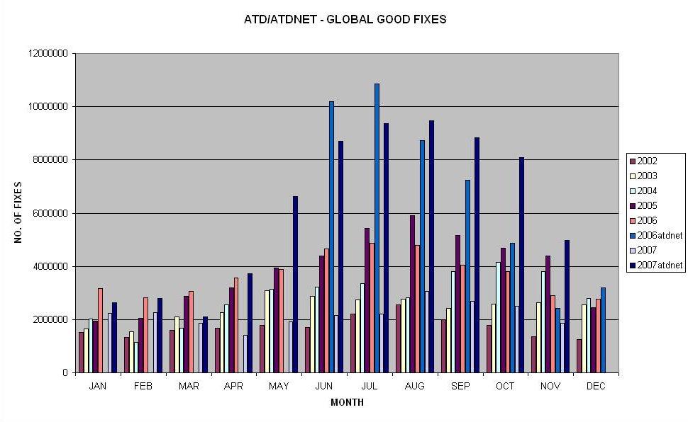
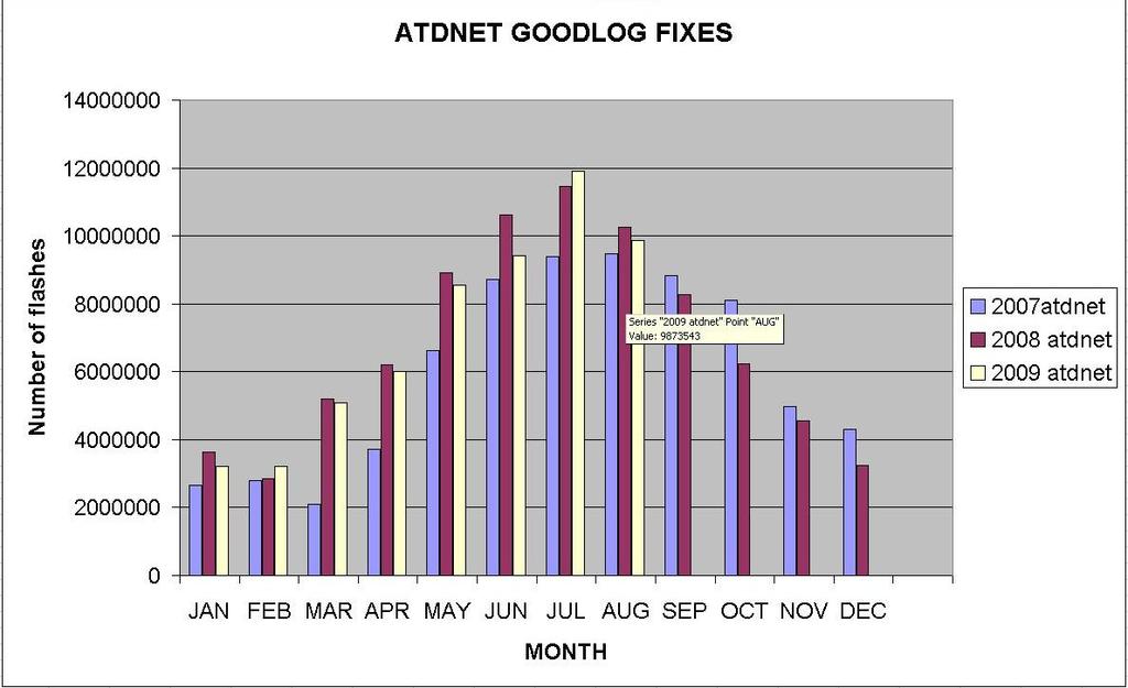
28 ATDNET climatology for June 2007
29 ATDNET climatology for September 2007

30 ATDNET climatology for November 2007
31 UK Met Office ATD system
32 UK Met Office ATD system Frequencies around 9 to 10 khz used since 1939 Originally as CRDF, but Arrival Time Difference since 1987 At these frequencies the sky waves, reflected off the ionosphere, propagate for very large distances with relatively little attenuation and are preceded by a ground wave at shorter ranges. Thus, it is possible to receive the emissions from the cloud to ground strokes at thousands of kilometres from the stroke location. A distributed network of ground based sensors can locate the origin of the lightning stroke, using the time differences between the arrivals of the lightning emission at the individual sensor sites.
33 UK Met Office ATD system Currently 11 sensors, but there are plans to install more Monitoring in 2004 showed increasing levels of interference around the original centre frequency 9.766kHz so this was moved to kHz in 2007, but with some loss of performance. Measurement bandwidth 3kHz. This is a completely passive service No international recognition exists so far for use of these frequencies for lightning detection despite being used since 1939, as none seemed to be necessary until now, hence WRC-12 AI1.16. ATD has always co-existed with radionavigation services at these frequencies, with notch filters being used where necessary.
34 Arrival Time Difference fixing process Accurate time calibration - rubidium oscillators, checked by GPS Waveforms are Fourier analysed and sent to the central control station on request Waveforms from different outstations are correlated to estimate time differences Arrival Time Differences are then used to calculate lightning position by iterative method Distribution of data messages every five minutes Future Communications use VPN

35 24 August 15Z,2007
")

36 Current (Sep 2009) ATD system network coverage
37
38 Conclusions Satellite and ground based systems observe different activity in storms Identification of cloud to ground strikes is essential for safety operations and is best performed with ground based systems Relationship between thunderstorm activity and convection is complex,as the significance of the ice phase in convection varies with each event The ratio of cloud to ground strokes to intracloud activity is probably different from sea to land.
39 Questions and answers
40 6 stations 5 hyperbolae
41
Vaisala Blitzdetektion. Michael Kalkum
 Vaisala Blitzdetektion Michael Kalkum 12.11.2013 What Is Lightning? Lightning is a transient, high-current electrical discharge Lightning stroke is typically 30.000 C Lightning takes the path of least
Meteosat Third Generation (MTG): Lightning Imager and its products Jochen Grandell
: Lightning Imager and its products Jochen Grandell") 1 Go to View menu and click on Slide Master to update this footer. Include DM reference, version number and date Meteosat Third Generation (MTG): Lightning Imager and its products Jochen Grandell Topics
1 Go to View menu and click on Slide Master to update this footer. Include DM reference, version number and date Meteosat Third Generation (MTG): Lightning Imager and its products Jochen Grandell Topics
Improving real time observation and nowcasting RDT. E de Coning, M Gijben, B Maseko and L van Hemert Nowcasting and Very Short Range Forecasting
 Improving real time observation and nowcasting RDT E de Coning, M Gijben, B Maseko and L van Hemert Nowcasting and Very Short Range Forecasting Introduction Satellite Application Facilities (SAFs) are
Research on Lightning Nowcasting and Warning System and Its Application
 Research on Lightning Nowcasting and Warning System and Its Application Wen Yao Chinese Academy of Meteorological Sciences Beijing, China yaowen@camscma.cn 2016.07 1 CONTENTS 1 2 3 4 Lightning Hazards
VALIDATION OF VAISALA S GLOBAL LIGHTNING DATASET (GLD360)
") VALIDATION OF VAISALA S GLOBAL LIGHTNING DATASET (GLD360) Nicholas W. S. Demetriades, Heikki Pohjola, Martin J. Murphy, and John A. Cramer Vaisala Inc., 2705 East Medina Road Tucson, AZ, USA +15208067523,
VALIDATION OF VAISALA S GLOBAL LIGHTNING DATASET (GLD360) Nicholas W. S. Demetriades, Heikki Pohjola, Martin J. Murphy, and John A. Cramer Vaisala Inc., 2705 East Medina Road Tucson, AZ, USA +15208067523,
3-Dimensional Lightning Observations Using a Time-of-Arrival Lightning Mapping System
 2001-01-2881 3-Dimensional Lightning Observations Using a Time-of-Arrival Lightning Mapping System William Rison, Paul Krehbiel, Ron Thomas, Tim Hamlin, and Jeremiah Harlin Copyright c 2001 Society of
Model enhancement & delivery plans, RAI
 Model enhancement & delivery plans, RAI Karen McCourt, UK VCP Manager 12 th June 2013 Outline Current model outputs & dissemination Future model outputs & dissemination New website for dissemination to
16D.2 VALIDATION OF VAISALA S GLOBAL LIGHTNING DATASET (GLD360) OVER THE CONTINENTAL UNITED STATES
 OVER THE CONTINENTAL UNITED STATES") 16D.2 VALIDATION OF VAISALA S GLOBAL LIGHTNING DATASET (GLD360) OVER THE CONTINENTAL UNITED STATES Nicholas W. S. Demetriades, Martin J. Murphy, John A. Cramer Vaisala Inc. Tucson, Arizona 85756 1. INTRODUCTION
16D.2 VALIDATION OF VAISALA S GLOBAL LIGHTNING DATASET (GLD360) OVER THE CONTINENTAL UNITED STATES Nicholas W. S. Demetriades, Martin J. Murphy, John A. Cramer Vaisala Inc. Tucson, Arizona 85756 1. INTRODUCTION
Description of the case study
 Description of the case study During the night and early morning of the 14 th of July 011 the significant cloud layer expanding in the West of the country and slowly moving East produced precipitation
Promising results for lightning predictions
 from Newsletter Number 155 Spring 2018 METEOROLOGY Promising results for lightning predictions Cover image: mishoo/istock/thinkstock doi:10.21957/plz731tyg2 This article appeared in the Meteorology section
Comparison and characterisation of ATDnet versus LIS for the period of 2008 to 2014
 Comparison and characterisation of ATDnet versus LIS for the period of 2008 to 2014 Sven-Erik Enno, Jacqueline Sugier, Lorenzo Labrador Observations Met Office Exeter, United Kingdom sven-erik.enno@metoffice.gov.uk
Keywords: lightning climatology; lightning flashes; Macedonia Greece.
 International Scientific Conference GEOBALCANICA 2018 A 10-YEAR CLIMATOLOGY OF LIGHTNING FOR MACEDONIA, GREECE Paraskevi Roupa 1 Theodore Karacostas 2 1 Hellenic National Meteorological Service, Greece
low for storms producing <1 flash min, medium 1 for storms producing 1-3 flashes min, and high for 1
 Figure 1. Coverage of the Oklahoma Lightning Mapping Array. The inner circle having a radius of 75 km indicates roughly where lightning can be mapped in three dimensions. The outer 200-km radius circle
1.4 GLOBAL STUDIES OF TROPICAL CYCLONES USING THE WORLD WIDE LIGHTNING LOCATION NETWORK
 1.4 GLOBAL STUDIES OF TROPICAL CYCLONES USING THE WORLD WIDE LIGHTNING LOCATION NETWORK Natalia N. Solorzano 1 *, Jeremy N. Thomas 2,3, and Robert H. Holzworth 2 1 Digipen Institute of Technology, Redmond,
Automated Thunderstorm Alert Service (ATSAS) User Guide
 User Guide") Automated Thunderstorm Alert Service (ATSAS) User Guide November 2016 Table of Contents 1 ATSAS System...2 1.1.1 Background Map... 3 1.1.2 Thunderstorm Cell and Trac k... 3 1.1.3 Legend... 4 1.1.4 ATSAS
Automated Thunderstorm Alert Service (ATSAS) User Guide November 2016 Table of Contents 1 ATSAS System...2 1.1.1 Background Map... 3 1.1.2 Thunderstorm Cell and Trac k... 3 1.1.3 Legend... 4 1.1.4 ATSAS
CLOUD-TO-GROUND LIGHTNING OVER THE INDIAN SUBCONTINENT. Amitabh Nag Florida Institute of Technology, Melbourne, Florida
 2017 American Meteorological Society Annual Meeting, Seattle, Washington 8 th Conference on the Meteorological Applications of Lightning Data, Paper 861 CLOUD-TO-GROUND LIGHTNING OVER THE INDIAN SUBCONTINENT
Vaisala s NLDN and GLD360 performance improvements and aviation applications. Nick Demetriades Head of Airports Vaisala 2015 Fall FPAW
 Vaisala s NLDN and GLD360 performance improvements and aviation applications Nick Demetriades Head of Airports Vaisala 2015 Fall FPAW Introduction Continuous CONUS Data Since 1989 The U.S. National Lightning
CHARACTERISATION OF STORM SEVERITY BY USE OF SELECTED CONVECTIVE CELL PARAMETERS DERIVED FROM SATELLITE DATA
 CHARACTERISATION OF STORM SEVERITY BY USE OF SELECTED CONVECTIVE CELL PARAMETERS DERIVED FROM SATELLITE DATA Piotr Struzik Institute of Meteorology and Water Management, Satellite Remote Sensing Centre
Judit Kerényi. OMSZ-Hungarian Meteorological Service P.O.Box 38, H-1525, Budapest Hungary Abstract
 Comparison of the precipitation products of Hydrology SAF with the Convective Rainfall Rate of Nowcasting-SAF and the Multisensor Precipitation Estimate of EUMETSAT Judit Kerényi OMSZ-Hungarian Meteorological
Lightning activity analyses with respect to the SPCZ location
 Click Here for Full Article GEOPHYSICAL RESEARCH LETTERS, VOL. 34, L11807, doi:10.1029/2007gl029730, 2007 Lightning activity analyses with respect to the SPCZ location P. Ortéga 1 and T. Guignes 1 Received
Unique Vaisala Global Lightning Dataset GLD360 TM
 Unique Vaisala Global Lightning Dataset GLD360 TM / THE ONLY LIGHTNING DETECTION NETWORK CAPABLE OF DELIVERING SUCH HIGH-QUALITY DATA ANYWHERE IN THE WORLD GLD360 provides high-quality lightning data anywhere
Research on Lightning Warning with SAFIR Lightning Observation and Meteorological detection Data in Beijing-Hebei Areas
 Research on Lightning Warning with SAFIR Lightning Observation and Meteorological detection Data in Beijing-Hebei Areas Meng Qing 1 Zhang Yijun 1 Yao Wen 1 Zhu Xiaoyan 1 He Ping 1 Lv Weitao 1 Ding Haifang
Correlation between lightning types
 GEOPHYSICAL RESEARCH LETTERS, VOL. 34,, doi:10.1029/2007gl029476, 2007 Correlation between lightning types J. L. Lapp 1 and J. R. Saylor 1 Received 25 January 2007; revised 21 February 2007; accepted 20
Back to basics: From Sputnik to Envisat, and beyond: The use of satellite measurements in weather forecasting and research: Part 1 A history
 Back to basics: From Sputnik to Envisat, and beyond: The use of satellite measurements in weather forecasting and research: Part 1 A history Roger Brugge 1 and Matthew Stuttard 2 1 NERC Data Assimilation
Unique Vaisala Global Lightning Dataset GLD360 TM
 Unique Vaisala Global Lightning Dataset GLD360 TM / THE ONLY LIGHTNING DETECTION NETWORK CAPABLE OF DELIVERING HIGH-QUALITY DATA ANYWHERE IN THE WORLD GLD360 provides high-quality lightning data anywhere
Moroccan lightning detection network, topology, performance and management of the network
 Moroccan lightning detection network, topology, performance and management of the network Mohamed DAHOUI, Mohamed NBOU and Rabia MERROUCHI Moroccan Meteorological Center Tel (212)71302837, Fax: (212)22908593
GLD360 AIRPORT LIGHTNING WARNINGS
 GLD360 AIRPORT LIGHTNING WARNINGS Ronald L. Holle and Nicholas W. S. Demetriades Vaisala Inc. Tucson, Arizona 85756 1. INTRODUCTION A comparison was made of lightning warnings for areas on the scale of
Introduction to Climatology. GEOG/ENST 2331: Lecture 1
 Introduction to Climatology GEOG/ENST 2331: Lecture 1 Us! Graham Saunders (RC 2006C) graham.saundersl@lakeheadu.ca! Jason Freeburn (RC 2004) jtfreebu@lakeheadu.ca Graham Saunders! Australian Weather Bureau!
Lightning in Florida. Henry E. Fuelberg Department of Meteorology Florida State University
 Lightning in Florida Henry E. Fuelberg Department of Meteorology Florida State University Lightning Facts ~ 20 million cloud to ground flashes in U.S. each year Half have more than one strike point 30
Introduction to upper air measurements with radiosondes and other in situ observing systems. John Nash, C. Gaffard,R. Smout and M.
 Introduction to upper air measurements with radiosondes and other in situ observing systems John Nash, C. Gaffard,R. Smout and M. Smees Observation Development, Met Office, Exeter Integrated Ground-based
THUNDERSTORM OCCURENCE AND ASSOCIATED FLIGHT HAZARDS IN THE SOUTHERN PART OF ROMANIA
 SCIENTIFIC RESEARCH AND EDUCATION IN THE AIR FORCE-AFASES 2016 THUNDERSTORM OCCURENCE AND ASSOCIATED FLIGHT HAZARDS IN THE SOUTHERN PART OF ROMANIA Carmen STEFAN Romanian Aviation Academy, Bucharest, Romania
16D.3 EYEWALL LIGHTNING OUTBREAKS AND TROPICAL CYCLONE INTENSITY CHANGE
 16D.3 EYEWALL LIGHTNING OUTBREAKS AND TROPICAL CYCLONE INTENSITY CHANGE Nicholas W. S. Demetriades and Ronald L. Holle Vaisala Inc., Tucson, Arizona, USA Steven Businger University of Hawaii Richard D.
Figure 5: Comparison between SAFIR warning and radar-based hail detection for the hail event of June 8, 2003.
 SAFIR WARNING : Expected risk Radar-based Probability of Hail 0915 0930 0945 1000 Figure 5: Comparison between SAFIR warning and radar-based hail detection for the hail event of June 8, 2003. Lightning
Use of lightning data to improve observations for aeronautical activities
 Use of lightning data to improve observations for aeronautical activities Françoise Honoré Jean-Marc Yvagnes Patrick Thomas Météo_France Toulouse France I Introduction Aeronautical activities are very
LIGHTNING LOCATION NETWORK ON THE EUROPEAN TERRITORY OF RUSSIA
 LIGHTNING LOCATION NETWORK ON THE EUROPEAN TERRITORY OF RUSSIA Snegurov A.V., Snegurov V.S. Voeikov A.I. Main Geophysical Observatory Russia, 194021, Saint-Petersburg, Karbysheva, 7 E-mail: snegurov_a@mail.ru
Lightning Parameters for Engineering Applications: Recent Updates and Outlook
 World Meeting on Lightning (WOMEL) Cartagena, Colombia, April 6-8, 2016 Lightning Parameters for Engineering Applications: Recent Updates and Outlook Vladimir A. Rakov Department of Electrical and Computer
European Studies of Coupling of Thunderstorms to the Upper Atmosphere
 European Studies of Coupling of Thunderstorms to the Upper Atmosphere Torsten Neubert National Space Institute Technical University of Denmark Christos Haldoupis University of Crete Content From Space
1.3 LIGHTNING AND RADAR OBSERVATIONS OF HURRICANE RITA LANDFALL 3. RADAR DATA
 1.3 LIGHTNING AND RADAR OBSERVATIONS OF HURRICANE RITA LANDFALL B. G. Henderson 1, *, D. M. Suszcynsky 1, K. C. Wiens 2, T. Hamlin 1, C. A. Jeffery 1, and R. E. Orville 3 1 Los Alamos Natl. Lab., Los Alamos,
Remote sensing of cloud-to-ground lightning location using the TOGA of sferics
 ATMOSPHERIC SCIENCE LETTERS Atmos. Sci. Let. 6: 128 132 (5) Published online 27 May 5 in Wiley InterScience (www.interscience.wiley.com). DOI: 1.2/asl.14 Remote sensing of cloud-to-ground lightning location
Life Cycle of Convective Systems over Western Colombia
 Life Cycle of Convective Systems over Western Colombia Meiry Sakamoto Uiversidade de São Paulo, São Paulo, Brazil Colombia Life Cycle of Convective Systems over Western Colombia Convective System (CS)
Single-site thunderstorm detector using combined electrostatic and radio frequency techniques
 Single-site thunderstorm detector using combined electrostatic and radio frequency techniques A J Bennett 1,2 1 Bristol Industrial and Research Associates Limited (Biral), P O Box 2, Portishead, Bristol,
Evaluating WWLLN performance relative to TRMM/LIS
 GEOPHYSICAL RESEARCH LETTERS, VOL. 40, 1 5, doi:10.1002/grl.50428, 2013 Evaluating WWLLN performance relative to TRMM/LIS Scott D. Rudlosky 1 and Dustin T. Shea 2 Received 8 March 2013; revised 27 March
Utilising Radar and Satellite Based Nowcasting Tools for Aviation Purposes in South Africa. Erik Becker
 Utilising Radar and Satellite Based Nowcasting Tools for Aviation Purposes in South Africa Erik Becker Morné Gijben, Mary-Jane Bopape, Stephanie Landman South African Weather Service: Nowcasting and Very
Satellite Meteorology. Protecting Life and Property Around the World
 Satellite Meteorology Protecting Life and Property Around the World The Value of Forecasting Severe Weather Flooding events across Europe in August 2002 cost in the region of 20 billion; 20,000 people
Present Status and Future Capabilities of Ground-Based Lightning Networks
 Present Status and Future Capabilities of Ground-Based Lightning Networks Presentation for the MTG Mission Team Jochen Grandell 6 March 2007 Slide: 1 TOPICS OF THE PRESENTATION Background for the study
Radiated VLF energy differences of land and oceanic lightning
 GEOPHYSICAL RESEARCH LETTERS, VOL., 5, doi:./grl.56, 3 Radiated VLF energy differences of land and oceanic lightning M. L. Hutchins, R. H. Holzworth, K. S. Virts, J. M. Wallace, and S. Heckman 3 Received
Comparison of cloud statistics from Meteosat with regional climate model data
 Comparison of cloud statistics from Meteosat with regional climate model data R. Huckle, F. Olesen, G. Schädler Institut für Meteorologie und Klimaforschung, Forschungszentrum Karlsruhe, Germany (roger.huckle@imk.fzk.de
The WMO Global Basic Observing Network (GBON)
") The WMO Global Basic Observing Network (GBON) A WIGOS approach to securing observational data for critical global weather and climate applications Robert Varley and Lars Peter Riishojgaard, WMO Secretariat,
The WMO Global Basic Observing Network (GBON) A WIGOS approach to securing observational data for critical global weather and climate applications Robert Varley and Lars Peter Riishojgaard, WMO Secretariat,
Air Mass Thunderstorms. Air Mass Thunderstorms. Air Mass Thunderstorms. Lecture 26 Air Mass Thunderstorms and Lightning
 Lecture 26 and Lightning Life Cycle Environment Climatology Lightning 1 2 Short-lived, isolated thunderstorms that are not severe are often called air-mass thunderstorms. There are three stages describing
THE IMPORTANCE OF ADVANCED OPERATIONAL RELIABILITY AND READINESS MONITORING OF THE SAFIR HMS LIGHTNING LOCALIZATION SYSTEM
 2006 19th International Lightning Detection Conference 24-25 April Tucson, Arizona, USA 1st International Lightning Meteorology Conference 26-27 April Tucson, Arizona, USA THE IMPORTANCE OF ADVANCED OPERATIONAL
P3.1 Development of MOS Thunderstorm and Severe Thunderstorm Forecast Equations with Multiple Data Sources
 P3.1 Development of MOS Thunderstorm and Severe Thunderstorm Forecast Equations with Multiple Data Sources Kathryn K. Hughes * Meteorological Development Laboratory Office of Science and Technology National
Nitrogen oxide emissions from lightning: Global source rate and tropical/mid-latitude differences
 Nitrogen oxide emissions from lightning: Global source rate and tropical/mid-latitude differences Ulrich Schumann, Heidi Huntrieser and Volker Grewe DLR Institute of Atmospheric Physics Oberpfaffenhofen,
On the occurrence of the equatorial F-region irregularities during solar minimum using radio occultation measurements
 On the occurrence of the equatorial F-region irregularities during solar minimum using radio occultation measurements B. A. Carter1, K. Zhang1, R. Norman1, V. V. Kumar2 and S. Kumar3 RMIT University, Australia
Impact of lightning on JEM-EUSO, and correlation between lightning and cloud-top altitude
 Impact of lightning on JEM-EUSO, and correlation between lightning and cloud-top altitude R. CINTRAT 1, R. CREMONINI 2,3, M. BERTAINA 3, R. BECHINI 2 1 Université de Nice, France; 2 Universita di Torino,
Response of the London Volcanic Ash Advisory Centre to the Eyjafjallajökull Eruption
 Paper 1B.3 Response of the London Volcanic Ash Advisory Centre to the Eyjafjallajökull Eruption Ian Lisk, Volcanic Ash Programme Manager, Met Office, UK 1. INTRODUCTION The Met Office is home to the London
ADL110B ADL120 ADL130 ADL140 How to use radar and strike images. Version
 ADL110B ADL120 ADL130 ADL140 How to use radar and strike images Version 1.00 22.08.2016 How to use radar and strike images 1 / 12 Revision 1.00-22.08.2016 WARNING: Like any information of the ADL in flight
Communicating uncertainty from short-term to seasonal forecasting
 Communicating uncertainty from short-term to seasonal forecasting MAYBE NO YES Jay Trobec KELO-TV Sioux Falls, South Dakota USA TV weather in the US Most TV weather presenters have university degrees and
Update on CoSPA Storm Forecasts
 Update on CoSPA Storm Forecasts Haig August 2, 2011 This work was sponsored by the Federal Aviation Administration under Air Force Contract No. FA8721-05-C-0002. Opinions, interpretations, conclusions,
LIGHTNING ACTIVITY AND CHARGE STRUCTURE OF MICROBURST PRODUCING STORMS
 LIGHTNING ACTIVITY AND CHARGE STRUCTURE OF MICROBURST PRODUCING STORMS Kristin M. Kuhlman, Travis M. Smith Cooperative Institute for Mesoscale Meteorological Studies, University of Oklahoma and NOAA/National
Observation of Cloud-to-Ground Lightning Channels with High-Speed Video Camera
 Observation of Cloud-to-Ground Lightning Channels with High-Speed Video Camera Buguet M. 1 *, P. Lalande 1, P. Blanchet 1, S. Pédeboy 2, P. Barneoud 2, P. Laroche 1 1. ONERA DMPH 29 avenue de la division
Comparison of TRMM LIS and PR with ground based lightning and radar observations for the TROCCINOX/ TroCCiBras/HIBISCUS field campaign
 Comparison of TRMM LIS and PR with ground based lightning and radar observations for the TROCCINOX/ TroCCiBras/HIBISCUS field campaign Thorsten Fehr, IPA/DLR, Germany Gerhard Held, IPMet/UNESP, Brazil
The Climatology of Clouds using surface observations. S.G. Warren and C.J. Hahn Encyclopedia of Atmospheric Sciences.
 The Climatology of Clouds using surface observations S.G. Warren and C.J. Hahn Encyclopedia of Atmospheric Sciences Gill-Ran Jeong Cloud Climatology The time-averaged geographical distribution of cloud
Preparation for FY-4A. (Submitted by Xiang Fang, CMA)
") WORLD METEOROLOGICAL ORGANIZATION COMMISSION FOR BASIC SYSTEMS OPEN PROGRAMME AREA GROUP ON INTEGRATED OBSERVING SYSTEMS EXPERT TEAM ON SATELLITE UTILIZATION AND PRODUCTS ET-SUP-8/Doc. 10.3 (2.IV.2014)
WORLD METEOROLOGICAL ORGANIZATION COMMISSION FOR BASIC SYSTEMS OPEN PROGRAMME AREA GROUP ON INTEGRATED OBSERVING SYSTEMS EXPERT TEAM ON SATELLITE UTILIZATION AND PRODUCTS ET-SUP-8/Doc. 10.3 (2.IV.2014)
Emerging Aviation Weather Research at MIT Lincoln Laboratory*
 Emerging Aviation Weather Research at MIT Lincoln Laboratory* Haig 19 November 2015 *This work was sponsored by the Federal Aviation Administration under Air Force Contract No. FA8721-05-C-0002. Opinions,
H-SAF VSA Programme HSAF_ CDOP2_VS14_03
 H-SAF VSA Programme HSAF_ CDOP2_VS14_03 Improvements on the PR-OBS-6 H-SAF precipitation product using multispectral markers from geostationary satellite data Final report Index 1. SCOPE OF THE DOCUMENT...
Government of Sultanate of Oman Public Authority of Civil Aviation Directorate General of Meteorology. National Report To
 Government of Sultanate of Oman Public Authority of Civil Aviation Directorate General of Meteorology National Report To Panel on Tropical Cyclones in the Bay of Bengal And Arabian Sea 43rd Session, India
APPENDIX 2 OVERVIEW OF THE GLOBAL PRECIPITATION MEASUREMENT (GPM) AND THE TROPICAL RAINFALL MEASURING MISSION (TRMM) 2-1
 AND THE TROPICAL RAINFALL MEASURING MISSION (TRMM) 2-1") APPENDIX 2 OVERVIEW OF THE GLOBAL PRECIPITATION MEASUREMENT (GPM) AND THE TROPICAL RAINFALL MEASURING MISSION (TRMM) 2-1 1. Introduction Precipitation is one of most important environmental parameters.
APPENDIX 2 OVERVIEW OF THE GLOBAL PRECIPITATION MEASUREMENT (GPM) AND THE TROPICAL RAINFALL MEASURING MISSION (TRMM) 2-1 1. Introduction Precipitation is one of most important environmental parameters.
OBSERVATIONS OF CLOUD-TO-GROUND LIGHTNING IN THE GREAT PLAINS
 OBSERVATIONS OF CLOUD-TO-GROUND LIGHTNING IN THE GREAT PLAINS S.A. Fleenor, K. L. Cummins 1, E. P. Krider Institute of Atmospheric Physics, University of Arizona, Tucson, AZ 85721-0081, U.S.A. 2 Also,
Report on the U.S. NLDN System-wide Upgrade. Vaisala's U.S. National Lightning Detection Network
 Michael J. Grogan Product Manager, Network Data and Software Vaisala Tucson, USA Vaisala's U.S. National Lightning Detection Network Report on the 2002-2003 U.S. NLDN System-wide Upgrade Two years ago,
Diurnal and Seasonal Variation of Surface Refractivity in Minna and Lapai, North Central Nigeria
 International Journal of Engineering Research and Advanced Technology (IJERAT) DOI: http://doi.org/10.31695/ijerat.2018.3283 E-ISSN : 2454-6135 Volume.4, Issue 7 July -2018 Diurnal and Seasonal Variation
Correlation between Lightning Impacts and Outages of Transmission Lines. H-D. BETZ Nowcast GmbH Munich Germany
 CIGRE C4 Colloquium on Power Quality and Lightning Sarajevo, Bosnia and Herzegovina, 13 16 May, 2012 Paper 01. Correlation between Lightning Impacts and Outages of Transmission Lines I. UGLEŠIĆ V. MILARDIĆ
Satellites, Weather and Climate Module 1: Introduction to the Electromagnetic Spectrum
 Satellites, Weather and Climate Module 1: Introduction to the Electromagnetic Spectrum What is remote sensing? = science & art of obtaining information through data analysis, such that the device is not
UPDATE OF REGIONAL WEATHER AND SMOKE HAZE (September 2017)
") UPDATE OF REGIONAL WEATHER AND SMOKE HAZE (September 2017) 1. Review of Regional Weather Conditions in August 2017 1.1 Southwest Monsoon conditions continued to prevail in the region in August 2017. The
UPDATE OF REGIONAL WEATHER AND SMOKE HAZE (September 2017) 1. Review of Regional Weather Conditions in August 2017 1.1 Southwest Monsoon conditions continued to prevail in the region in August 2017. The
"Experiences with use of EUMETSAT MPEF GII product for convection/storm nowcasting"
 "Experiences with use of EUMETSAT MPEF GII product for convection/storm nowcasting" Marianne König 1, Monika Pajek 2, Piotr Struzik 2 1) EUMETSAT 2) Institute of Meteorology and Water Management, Kraków,
INVESTIGATION OF SAHARAN DUST TRANSPORT ON THE BASIS OF AEROLOGICAL MEASUREMENTS
 INVESTIGATION OF SAHARAN DUST TRANSPORT ON THE BASIS OF AEROLOGICAL MEASUREMENTS R. TÓTH 1, L. NYITRAI 1 ABSTRACT. Investigation of Saharan dust transport on the basis of aerological measurements. The
Determining Hurricane Formation in the eastern North Pacific Using the Global Lightning Dataset 360 and the Long-Range Lightning Detection Network
 Determining Hurricane Formation in the eastern North Pacific Using the Global Lightning Dataset 360 and the Long-Range Lightning Detection Network Lesley A. L. Mazzarella and Elizabeth A. Ritchie (of University
VAISALA GLOBAL LIGHTNING DATASET GLD360
 VAISALA GLOBAL LIGHTNING DATASET GLD360 Technology, operations, and applications overview JULY 2009 MIke Grogan Application Services Manager Observation Services Nick Demetriades Applications Manager,
Visualizing Geostationary Lightning Mapper Data
 Visualizing Geostationary Lightning Mapper Data Scott D. Rudlosky NOAA/NEDIS/STAR University of Maryland College Park, MD, USA scott.rudlosky@noaa.gov Michael J. Peterson Earth System Science Interdisciplinary
Seasonal Climate Outlook for South Asia (June to September) Issued in May 2014
 Issued in May 2014") Ministry of Earth Sciences Earth System Science Organization India Meteorological Department WMO Regional Climate Centre (Demonstration Phase) Pune, India Seasonal Climate Outlook for South Asia (June
Ministry of Earth Sciences Earth System Science Organization India Meteorological Department WMO Regional Climate Centre (Demonstration Phase) Pune, India Seasonal Climate Outlook for South Asia (June
Preliminary results. Leonardo Calvetti, Rafael Toshio, Flávio Deppe and Cesar Beneti. Technological Institute SIMEPAR, Curitiba, Paraná, Brazil
 HIGH RESOLUTION WRF SIMULATIONS FOR WIND GUST EVENTS Preliminary results Leonardo Calvetti, Rafael Toshio, Flávio Deppe and Cesar Beneti Technological Institute SIMEPAR, Curitiba, Paraná, Brazil 3 rd WMO/WWRP
AMS. calendar of meetings AMERICAN METEOROLOGICAL SOCIETY. Anaheim, CA. *73rd AMS Annual Meeting January January
 Monterey, Mexico Salt Lake City, UT Albuquerque, NM Hobart, Australia Orlando, FL Seattle, WA Wiesbaden, Germany San Antonio, TX 16-18 February 8-12 March 22-25 March 29 March-2 April 14-16 April 13-16
 1 2 3 US Air Force 557 th Weather Wing maintains a website with many operational products both on terrestrial as on space weather. The operational holy grail for the military are stoplight charts, indicating
A COMPARISON OF THE LIGHTNING JUMP ALGORITHM USING TOTAL LIGHTNING VERSUS CLOUD-TO-GROUND FLASHES.
 A COMPARISON OF THE LIGHTNING JUMP ALGORITHM USING TOTAL LIGHTNING VERSUS CLOUD-TO-GROUND FLASHES. Rigo, T. (1), C. Farnell (1, 2) (1) Servei Meteorologic de Catalunya (2) University of Barcelona. Faculty
Weather Satellite Data Applications for Monitoring and Warning Hazard at BMKG
 The 5th Meeting of the Coordinating Group of the RA II WIGOS Satellite Project 21 October 2017, Vladivostok city, Russky Island, Russia Far Eastern Federal University Weather Satellite Data Applications
The Spatial Relationship Between Lightning and CAPE
 The Spatial Relationship Between Lightning and CAPE By Stephanie Bradshaw An Undergraduate Thesis Submitted in partial fulfillment of the Bachelor of Arts Degree in Geography and Earth Science Carthage
III. Section 3.3 Vertical air motion can cause severe storms
 III. Section 3.3 Vertical air motion can cause severe storms http://www.youtube.com/watch?v=nxwbr60tflg&feature=relmfu A. Thunderstorms form from rising moist air Electrical charges build up near the tops
Observational Needs for Polar Atmospheric Science
 Observational Needs for Polar Atmospheric Science John J. Cassano University of Colorado with contributions from: Ed Eloranta, Matthew Lazzara, Julien Nicolas, Ola Persson, Matthew Shupe, and Von Walden
FUNDAMENTALS OF REMOTE SENSING FOR RISKS ASSESSMENT. 1. Introduction
 FUNDAMENTALS OF REMOTE SENSING FOR RISKS ASSESSMENT FRANÇOIS BECKER International Space University and University Louis Pasteur, Strasbourg, France; E-mail: becker@isu.isunet.edu Abstract. Remote sensing
GOES-16 & GOES-S: Natalia Donoho. Preparing Users for New Generation Satellites. WMO IPET-SUP-4 Geneva, Switzerland 26 February, 2018
 GOES-16 & GOES-S: Preparing Users for New Generation Satellites Natalia Donoho Satellite Products and Services Division (NOAA/NESDIS) WMO IPET-SUP-4 Geneva, Switzerland 26 February, 2018 GOES-R series
What Measures Can Be Taken To Improve The Understanding Of Observed Changes?
 What Measures Can Be Taken To Improve The Understanding Of Observed Changes? Convening Lead Author: Roger Pielke Sr. (Colorado State University) Lead Author: David Parker (U.K. Met Office) Lead Author:
Space Weather Awareness in the Arctic. Torsten Neubert Head of Section for Solar System Physics
 Space Weather Awareness in the Arctic Torsten Neubert Head of Section for Solar System Physics Technology in the Arctic There is significant potential Resources Tourism helped by receding ocean ice There
AERODROME METEOROLOGICAL OBSERVATION AND FORECAST STUDY GROUP (AMOFSG)
") AMOFSG/10-IP/4 21/5/13 AERODROME METEOROLOGICAL OBSERVATION AND FORECAST STUDY GROUP (AMOFSG) TENTH MEETING Montréal, 17 to 19 June 2013 Agenda Item 5: Aerodrome observations AUTOMATED CLOUD INFORMATION
AMOFSG/10-IP/4 21/5/13 AERODROME METEOROLOGICAL OBSERVATION AND FORECAST STUDY GROUP (AMOFSG) TENTH MEETING Montréal, 17 to 19 June 2013 Agenda Item 5: Aerodrome observations AUTOMATED CLOUD INFORMATION
INTERPRETATION OF MSG IMAGES, PRODUCTS AND SAFNWC OUTPUTS FOR DUTY FORECASTERS
 INTERPRETATION OF MSG IMAGES, PRODUCTS AND SAFNWC OUTPUTS FOR DUTY FORECASTERS M. Putsay, M. Rajnai, M. Diószeghy, J. Kerényi, I.G. Szenyán and S. Kertész Hungarian Meteorological Service, H-1525 Budapest,
Global Instability Index: Product Guide
 Doc.No. Issue : : EUM/TSS/MAN/15/802106 v1c e-signed EUMETSAT Eumetsat-Allee 1, D-64295 Darmstadt, Germany Tel: +49 6151 807-7 Fax: +49 6151 807 555 Date : 2 September 2015 http://www.eumetsat.int WBS/DBS
Exercise Brunswick ALPHA 2018
 ALPHA Exercise Brunswick ALPHA 2018 Who we are (our structure) What we do (our forecasts) How you can access the information Tropical cyclone information (basic) Overview of the products used for Exercise
National Lightning Detection Network (NLDN) performance in southern Arizona, Texas, and Oklahoma in
 performance in southern Arizona, Texas, and Oklahoma in") Click Here for Full Article JOURNAL OF GEOPHYSICAL RESEARCH, VOL. 112,, doi:10.1029/2006jd007341, 2007 National Lightning Detection Network (NLDN) performance in southern Arizona, Texas, and Oklahoma in
Click Here for Full Article JOURNAL OF GEOPHYSICAL RESEARCH, VOL. 112,, doi:10.1029/2006jd007341, 2007 National Lightning Detection Network (NLDN) performance in southern Arizona, Texas, and Oklahoma in
WEATHER AND CLIMATE EXTREMES MONITORING BASED ON SATELLITE OBSERVATION : INDONESIA PERSPECTIVE RIRIS ADRIYANTO
 WEATHER AND CLIMATE EXTREMES MONITORING BASED ON SATELLITE OBSERVATION : INDONESIA PERSPECTIVE RIRIS ADRIYANTO INDONESIA AGENCY FOR METEOROLOGY, CLIMATOLOGY AND GEOPHYSICS (BM KG) 1. INTRODUCTION - BMKG
Electrical thunderstorm nowcasting using lightning data mining
 Data Mining VII: Data, Text and Web Mining and their Business Applications 161 Electrical thunderstorm nowcasting using lightning data mining C. A. M. Vasconcellos 1, C. L. Curotto 2, C. Benetti 1, F.
TIME EVOLUTION OF A STORM FROM X-POL IN SÃO PAULO: 225 A ZH-ZDR AND TITAN METRICS COMPARISON
 TIME EVOLUTION OF A STORM FROM X-POL IN SÃO PAULO: 225 A ZH-ZDR AND TITAN METRICS COMPARISON * Roberto V Calheiros 1 ; Ana M Gomes 2 ; Maria A Lima 1 ; Carlos F de Angelis 3 ; Jojhy Sakuragi 4 (1) Voluntary