Volcanic ash emergency in Northern Europe
|
|
|
- James Horn
- 6 years ago
- Views:
Transcription
1 FORMAT-EO Leicester Volcanic ash emergency in Northern Europe The application of remote sensing techniques Group 3 Carlos Melo; Stefano Capobianco & Rejanne Le Bivic Tutor: Alfredo Falconieri 2013
2 Introduction Research problem How to monitor properly a volcanic ash cloud? Which parameters? How the monitoring methods can affect the decisionmaking process? EO Economy What did the Eyjafjallajokull events change in the decision making process? What can be improved in the future (instrumentation, organisation, decision making process)? EO + Economy

3 Introduction Why? flights every day Site URL:

 Map of the last 50 last")
4 Introduction Why? Evolution of worldwide air traffic in number of passengers (Source : Airbus) Map of the last 50 last eruptions worldwide

5
6 Contents Volcanic ash clouds Case study context Different monitoring methodologies Dataset, methodology and results Discussion
7 Volcanic Ash clouds
 Site URL http://asomadosdias.files.wordpress.com/2009/11/vulcao-dos-capelinhos91.")
8 Volcanic Ash clouds Case study Monitoring Methods Methodology and Results Discussion Capelinhos eruption (1957) Site URL


9 Volcanic Ash clouds Case study Monitoring Methods Methodology and Results Chemical analysis of volcanic ash Discussion
 Abrasive action erosion of the cockpit windshields. Melting of volcanic ash ash clouds melts with the engines high temperature.")
10 Effects of volcanic ash clouds on civil jet planes Abrasive action moving parts gets eroded by direct contact with the ash cloud. Modified from Casadevall (1993) Abrasive action erosion of the cockpit windshields. Melting of volcanic ash ash clouds melts with the engines high temperature. Posterior solidification results in engine bad function and can result in complete stop. Obstruction of data acquirement systems results in lost of majority of the automatic systems


11 Volcanic Ash clouds Case study Monitoring Methods Methodology and Results Discussion Case study context : geography Google EarthEngine Eyjafjallajökull : Lat N Long W (WGS84)


12 Volcanic Ash clouds Case study Monitoring Methods Methodology and Results Discussion Case study context : geology R.G. Trønnes, Nordic volcanological Institute, University of Iceland
13 Volcanic Ash clouds Case study Monitoring Methods Methodology and Results Discussion Case study context The Eyjafjallajökull eruption 2010 Phreato -magmatic phase Magmatic phase Few months Crustal deformation Enhanced seismic activity Under-ice explosive eruption Outbreak of the central cratere melting the ice cap 5-9km high eruption column Few tons/sec Very fine to fine trachyandesite composition Lower intensity Plumes 4km Gaining intensity Plume 6km
14 Volcanic Ash clouds Case study Monitoring Methods Methodology and Results Discussion Volcanic ash clouds observations Monitoring by the IMO and the IES GPS-based ground def measurements Radar Surveillance flights Seismicity But need for large-scale information of the dispersion

15 Volcanic Ash Advisory Centres Site URL:

16 Volcanic Ash clouds Case study Monitoring Methods Methodology and Results Discussion Different monitoring methodologies Data acquisition methods
17 Volcanic Ash clouds Case study Monitoring Methods Methodology and Results Discussion Generation of ash advisories using satellite data Needed : Horizontal resolution of 1-10km Vertical data : column estimates Geosynchronous meteorological imagery : SEVIRI, GOES and MTSAT Polar Orbiting operational sensors : NOAA/AVHRRs
18 Dataset, methodology and results
 The main satellite based methods for detecting and discriminating volcanic ash clouds (ESA,")
19 Volcanic Ash clouds Case study Monitoring Methods Methodology and Results Discussion Methodology Thermal imagery Brightness Temperatures Difference (BTD) The main satellite based methods for detecting and discriminating volcanic ash clouds (ESA, 2010)
 Instrument characteristics : 12 spectral channels (4 Visible and Near-InfraRed channels, 8IR channels) Baseline repeated cycle 15 min Manufactured under the leadership of Astrium in")
20 Volcanic Ash clouds Case study Monitoring Methods Methodology and Results Discussion MSG s SEVIRI The main SEVIRI instrument Unit Optical imaging radiometer : Spinning Enhanced Visible and Infrared Imager (SEVIRI) Instrument characteristics : 12 spectral channels (4 Visible and Near-InfraRed channels, 8IR channels) Baseline repeated cycle 15 min Manufactured under the leadership of Astrium in Toulouse (France) Line-in-line scanning radiometer km altitude High res 1km visible channel IR and other 3 visible channels 3km 260kg 2,43m high
21 Volcanic Ash clouds Case study Monitoring Methods Methodology and Results Discussion Methodologie BTD (Prata, 1989) T11 T12 > 0 (cloud) T11 T12 < 0 (ash)


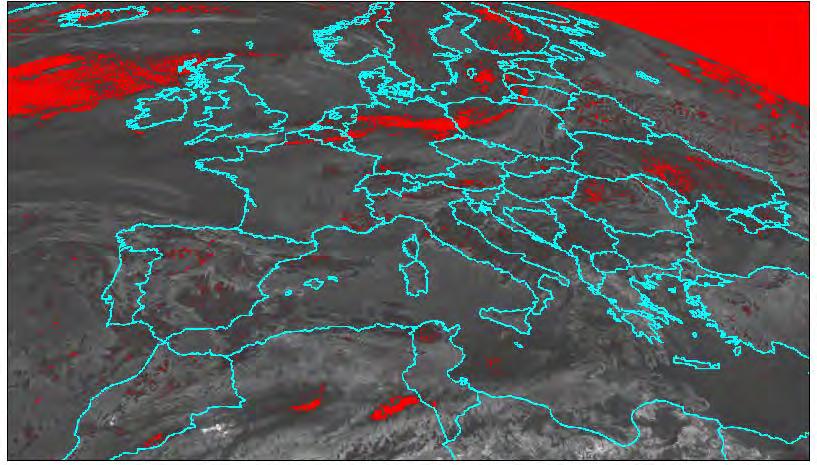
22 Events Eyiafjallajokull 15/04/ :00-06:00-12:00-18:00 Ash Detection BTD (Brightness Temperature Difference) [Prata 1989] BTD < 0
23 Ash Detection Events Eyiafjallajokull 15/04/ :00 BTD (Brightness Temperature Difference) [Prata 1989] BTD < 0
24 Ash Detection Events Eyiafjallajokull 15/04/ :00 BTD (Brightness Temperature Difference) [Prata 1989] BTD < 0

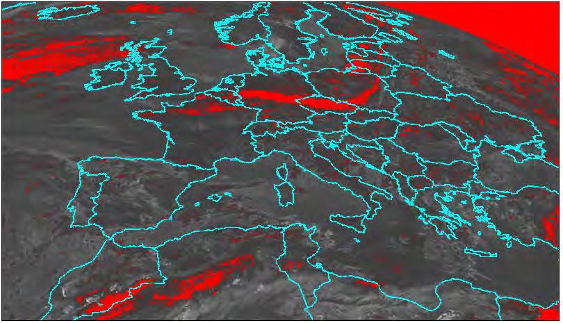
25 Events Eyiafjallajokull 16/04/ :00-06:00-12:00-18:00 Ash Detection BTD (Brightness Temperature Difference) [Prata 1989] BTD < 0
Near real-time monitoring of the April-May 2010 Eyjafjöll s ash cloud
 Near real-time monitoring of the April-May 2010 Eyjafjöll s ash cloud Labazuy P. and the HotVolc Team Observatoire de Physique du Globe de Clermont-Ferrand, CNRS, Université Blaise Pascal 13th International
Satellite techniques for timely detection and near real-time monitoring of volcanic ash clouds for aviation safety
 Satellite techniques for timely detection and near real-time monitoring of volcanic ash clouds for aviation safety N. Pergola A. Falconieri F. Marchese V. Tramutoli Consiglio Nazionale delle Ricerche Istituto
IVATF/4-WP/11 Revision 1 07/06/12. International WORKING PAPER IVATF TASK. (Presented SUMMARY 1.1. (5 pages)
") International Civil Aviation Organization WORKING PAPER Revision 1 07/06/12 INTERNATIONAL VOLCANIC ASH TASK FORCE (IVATF) FOURTH MEETING Montréal, 13 to 15 June 2012 Agenda Item 2: Report of the science
International Civil Aviation Organization WORKING PAPER Revision 1 07/06/12 INTERNATIONAL VOLCANIC ASH TASK FORCE (IVATF) FOURTH MEETING Montréal, 13 to 15 June 2012 Agenda Item 2: Report of the science
The Eyjafjallajokull Volcanic Ash Cloud and its Effects on Scottish Air Quality. Update 06 May 2010
 The Eyjafjallajokull Volcanic Ash Cloud and its Effects on Scottish Air Quality. Update 06 May 2010 The volcanic ash cloud from the Eyjafjallakull volcano once again grounded flights from Scottish airports
A-Train observations of the 2010 eruption of Eyjafjallajökull volcano (Iceland)
") A-Train observations of the 2010 eruption of Eyjafjallajökull volcano (Iceland) S.A. Carn 1, N.A. Krotkov 2, K. Yang 2, A.J. Prata 3 1. Michigan Technological University, Houghton, MI, USA 2. GEST Center,
A-Train observations of the 2010 eruption of Eyjafjallajökull volcano (Iceland) S.A. Carn 1, N.A. Krotkov 2, K. Yang 2, A.J. Prata 3 1. Michigan Technological University, Houghton, MI, USA 2. GEST Center,
DIFFERING REGIONAL CAPABILITIES IN SATELLITE-BASED VOLCANIC ASH CLOUD DETECTION
 Prepared by NOAA Agenda Item: II/8 Discussed in WGII DIFFERING REGIONAL CAPABILITIES IN SATELLITE-BASED VOLCANIC ASH CLOUD DETECTION The GOES-R AWG is responsible for the developing the algorithms that
Forecasting Resuspended Volcanic Ash Clouds
 Forecasting Resuspended Volcanic Ash Clouds F. M. Beckett ADAQ: C.S. Witham, S.J. Leadbetter, M.C. Hort University of Bristol: E.J. Liu and K.V. Cashman NILU: A. Kylling frances.beckett@metoffice.gov.uk
The 2010 Eyjafjallajökull eruption: overview and OMI observations. Simon A. Carn Michigan Technological University, Houghton, MI, USA
 The 2010 Eyjafjallajökull eruption: overview and OMI observations Simon A. Carn Michigan Technological University, Houghton, MI, USA Global air routes and potentially active volcanoes Map courtesy of F.
Recommendation proposed: CGMS-39 WGII to take note.
 Prepared by EUMETSAT Agenda Item: G.II/8 Discussed in WGII EUM REPORT ON CAPABILITIES AND PLANS TO SUPPORT VOLCANIC ASH MONITORING In response to CGMS action WGII 38.31: CGMS satellite operators are invited
Volcanic Ash Monitoring Claus Zehner, ESA
 Volcanic Ash Monitoring Claus Zehner, ESA Slide: 1 Support to Aviation Control Service A global Alert (and Analysis demonstration only) system for volcanic Ash and SO2 emissions using satellite measurements
Eldgos í Eyjafjallajökli hlutverk Veðurstofu Íslands
 Photo: B. Pálmason Eldgos í Eyjafjallajökli hlutverk Veðurstofu Íslands Sigrún Karlsdóttir, Guðrún Nína Petersen, Halldór Björnsson, Halldór Pétursson, Hróbjartur Þorsteinsson, Kristín Vogfjörð og Þórður
Meteorological Priorities in Support of a Volcanic Ash Strategy ( )
") Meteorological Priorities in Support of a Volcanic Ash Strategy (2010-11) Ian Lisk, Met Office Volcanic Ash Coordination Programme Manager; EUMETNET VA coordinator; WMO CAeM vice-president. Introduction
Meteorological Priorities in Support of a Volcanic Ash Strategy (2010-11) Ian Lisk, Met Office Volcanic Ash Coordination Programme Manager; EUMETNET VA coordinator; WMO CAeM vice-president. Introduction
The Eyjafjallajökull eruption
 The Eyjafjallajökull eruption and its aftermath The monitoring and guidance process Photo: B. Pálmason Contents The role of IMO The role of London VAAC Volcanic Monitoring network and other observations
Ash RGB Detection of Volcanic Ash
 Copyright, JMA RGB Detection of Volcanic Meteorological Satellite Center, JMA Ver. 20150424 Volcanic Detection by Infrared and Difference Image, and Basis Himawari-8 B15-B13 2015-02-16 06:35 UTC Himawari-8
Volcanic ash retrieval at Mt. Etna using Avhrr and Modis data
 Volcanic ash retrieval at Mt. Etna using Avhrr and Modis data Claudia Spinetti* a, Stefano Corradini a, Maria F. Buongiorno a a Istituto Nazionale di Geofisica e Vulcanologia, via di Vigna Murata, 605
P3.13 GLOBAL COMPOSITE OF VOLCANIC ASH SPLIT ` WINDOW GEOSTATIONARY SATELLITE IMAGES
 P3.13 GLOBAL COMPOSITE OF VOLCANIC ASH SPLIT ` WINDOW GEOSTATIONARY SATELLITE IMAGES Frederick R. Mosher * Embry-Riddle Aeronautical University Daytona Beach, FL 1.0 Introduction Volcanic ash is exceptionally
The Eyjafjallajokull volcanic eruption
 Explain the formation of the volcano E15 and the causes of its eruptions. Describe the effects of the 2010 eruption. Make sure you can categorise these according to whether they are primary or secondary
Development of a System for Quantitatively Analyzing Volcanic Clouds
 Development of a System for Quantitatively Analyzing Volcanic Clouds Michael Pavolonis (NOAA/NESDIS/STAR) Justin Sieglaff and John Cintineo (UW-CIMSS) Marco Fulle - www.stromboli.net 2 nd IUGG-WMO Workshop
Advantageous GOES IR results for ash mapping at high latitudes: Cleveland eruptions 2001
 GEOPHYSICAL RESEARCH LETTERS, VOL. 32, L02305, doi:10.1029/2004gl021651, 2005 Advantageous GOES IR results for ash mapping at high latitudes: Cleveland eruptions 2001 Yingxin Gu, 1 William I. Rose, 1 David
Development of an ensemble-based volcanic ash dispersion model for operations at Darwin VAAC
 Development of an ensemble-based volcanic ash dispersion model for operations at Darwin VAAC Rodney Potts Bureau of Meteorology Australia [C Lucas, R Dare, M Manickam, A Wain, M Zidikheri, A Bear-Crozier]
Satellite Data For Applications: Aviation/Volcanic Ash. Richard Eckman NASA 27 May 2013
 Satellite Data For Applications: Aviation/Volcanic Ash Richard Eckman NASA 27 May 2013 Background Following the unprecedented disruption to aviation by the recent eruptions of Eyjafjallajökull and Grímsvötn
Applying Mass Eruption Rates in an Operational Dispersion Model
 Applying Mass Eruption Rates in an Operational Dispersion Model Frances Beckett, ADAQ, Met Office frances.beckett@metoffice.gov.uk MeMoVolc Workshop, University of Iceland, May 2016 The London Volcanic
FUTURE PLAN AND RECENT ACTIVITIES FOR THE JAPANESE FOLLOW-ON GEOSTATIONARY METEOROLOGICAL SATELLITE HIMAWARI-8/9
 FUTURE PLAN AND RECENT ACTIVITIES FOR THE JAPANESE FOLLOW-ON GEOSTATIONARY METEOROLOGICAL SATELLITE HIMAWARI-8/9 Toshiyuki Kurino Japan Meteorological Agency, 1-3-4 Otemachi Chiyodaku, Tokyo 100-8122,
Operations of VAAC. before/after Eyjafjalla2010. ESA / EUMESAT Workshop on Eyjafjalla eruption and ash monitoring from space.
 Operations of VAAC before/after Eyjafjalla2010 ESA / EUMESAT Workshop on Eyjafjalla eruption and ash monitoring from space Philippe Husson IAVW : 9 V A A C T.J Casadevall,., T. B Thompson,., and T. Fox
Inter-comparison MTSAT-2 & Himawari-8
 Inter-comparison MTSAT-2 & Himawari-8 WMO Volcanic Ash Advisory Centre Best Practice Workshop 2017 Tokyo Volcanic Ash Advisory Centre Japan Meteorological Agency Outline Introduction Method Case study
Eyja volcanic ash retrievals by using MODIS data
 INGV Eyja volcanic ash retrievals by using MODIS data S. Corradini, L. Merucci, A. Piscini Remote Sensing Group INGV (Rome) ESRIN May 26-27, 2010 Outline Ash retrieval algorithms in the TIR spectral range
" The usefulness of RGB products: the perspective of the Australian Bureau of Meteorology "
 " The usefulness of RGB products: the perspective of the Australian Bureau of Meteorology " Presenter: Bodo Zeschke. Bureau of Meteorology Training Centre, Australian VLab Centre of Excellence Point of
Satellite observation of atmospheric dust
 Satellite observation of atmospheric dust Taichu Y. Tanaka Meteorological Research Institute, Japan Meteorological Agency 11 April 2017, SDS WAS: Dust observation and modeling @WMO, Geneva Dust observations
Response of the London Volcanic Ash Advisory Centre to the Eyjafjallajökull Eruption
 Paper 1B.3 Response of the London Volcanic Ash Advisory Centre to the Eyjafjallajökull Eruption Ian Lisk, Volcanic Ash Programme Manager, Met Office, UK 1. INTRODUCTION The Met Office is home to the London
Development of volcanic ash product for the next-generation Japanese Geostationary Meteorological Satellite Himawari-8
 Development of volcanic ash product for the next-generation Japanese Geostationary Meteorological Satellite Himawari-8 Hiroaki Tsuchiyama 1, Yukio Kurihara 1, Kazuhiko Masuda 2 (1) Japan Meteorological
Current capabilities and limitations of satellite monitoring and modeling forecasting of volcanic clouds: and example of Eyjafjallaj
 Current capabilities and limitations of satellite monitoring and modeling forecasting of volcanic clouds: and example of Eyjafjallaj fjallajökull eruption (pronounced EYE-a-fyat fyat-la-jo-kotl) N. Krotkov
METEOSAT THIRD GENERATION
 METEOSAT THIRD GENERATION FACTS AND FIGURES MONITORING WEATHER AND CLIMATE FROM SPACE A HIGHLY INNOVATIVE GEOSTATIONARY SATELLITE SYSTEM FOR EUROPE AND AFRICA The Meteosat Third Generation (MTG) system
Validation and evaluation of SEVIRI volcanic ash heights
 Validation and evaluation of SEVIRI volcanic ash heights A.T.J. de Laat and R.J. van der A De Bilt, 2012 Technical report; TR-337 Validation and evaluation of SEVIRI volcanic ash heights. Version 1.0
Explosive volcanic eruptions in the North Pacific: Interactions between the Alaska Volcano Observatory and Volcanic Ash Advisory Centers
 Explosive volcanic eruptions in the North Pacific: Interactions between the Alaska Volcano Observatory and Volcanic Ash Advisory Centers David Schneider U.S. Geological Survey Alaska Volcano Observatory
EUMETNET Statement for the EASA Workshop Volcanic Ash Cloud: Detection, Observation, Measurement, Modelling The Way Forward
 EUMETNET Statement for the EASA Workshop Volcanic Ash Cloud: Detection, Observation, Measurement, Modelling The Way Forward Cologne, 21 st June 2010 Background GIE EUMETNET (the network of European Meteorological
Volcanic eruptions: Introduction to remote sensing techniques for fine ash and SO2 detection
 Volcanic eruptions: Introduction to remote sensing techniques for fine ash and SO2 detection Bernie Connell Cooperative Institute for Research in the Atmosphere Colorado State University USA Ash clouds
MSG system over view
 MSG system over view 1 Introduction METEOSAT SECOND GENERATION Overview 2 MSG Missions and Services 3 The SEVIRI Instrument 4 The MSG Ground Segment 5 SAF Network 6 Conclusions METEOSAT SECOND GENERATION
SIXTH MEETING. (Presented by SUMMARY
 12/9/11 INTERNATIONAL AIRWAYS VOLCANO WATCH OPERATIONS GROUP (IAVWOPSG) SIXTH MEETING Dakar, Senegal, 19 to 23 September 20111 Agenda Item 5: Operation of the IAVW 5.2: Improvement of the format and content
Earthquake and Volcano Service
 Ref. Ares(2014)73773-15/01/2014 Earthquake and Volcano Service WP Leader: Istituto Nazionale di Geofisica e Vulcanologia (Italy) Contributors: NILU (Norway), EUCENTRE (Italy), GAMMA (Switzerland), IGAR
Dispersion modelling and warnings for volcanic ash in the Australian Region
 Dispersion modelling and warnings for volcanic ash in the Australian Region R Potts, R Dare, E Jansons, C Lucas, A Tupper, M Zidikheri The Centre for Australian Weather and Climate Research A partnership
INTERNATIONAL CIVIL AVIATION ORGANIZATION
 INTERNATIONAL CIVIL AVIATION ORGANIZATION WESTERN AND CENTRAL AFRICA OFFICE (WACAF) ICAO Regional Seminar on ATS/MET/Pilots Coordination (Yaoundé, Cameroon, 23 25 August 2010) Agenda item 7 : Volcanic
Preparation for Himawari 8
 Preparation for Himawari 8 Japan Meteorological Agency Meteorological Satellite Center Hidehiko MURATA ET SUP 8, WMO HQ, Geneva, 14 17 April 2014 1/18 Introduction Background The Japan Meteorological Agency
The BEYOND Center of Excellence for monitoring natural disasters from space
 The BEYOND Center of Excellence for monitoring natural disasters from space Ioannis Papoutsis National Observatory of Athens Institute for Astronomy, Astrophysics, Space Applications & Remote Sensing MOWE-IT
University of Bristol - Explore Bristol Research
 Prata, F., Woodhouse, M. J., Huppert, H. E., Prata, A., Thordarson, TH., & Carn, S. A. (2017). Atmospheric processes affecting the separation of volcanic ash and SO2 in volcanic eruptions: Inferences from
Forecasting of volcanic ash for the Norwegian airspace
 Forecasting of volcanic ash for the Norwegian airspace Picture courtesy: Magnús Tumi Guðmundsson H. Fagerli, H. Klein, A. Nyiri, B. Steensen, M. Schulz, A. Mortier, A. Lauen Borg, A. Valdebenito, N. Kristiansen,
Meteosat Third Generation (MTG): Lightning Imager and its products Jochen Grandell
: Lightning Imager and its products Jochen Grandell") 1 Go to View menu and click on Slide Master to update this footer. Include DM reference, version number and date Meteosat Third Generation (MTG): Lightning Imager and its products Jochen Grandell Topics
1 Go to View menu and click on Slide Master to update this footer. Include DM reference, version number and date Meteosat Third Generation (MTG): Lightning Imager and its products Jochen Grandell Topics
INTERNATIONAL VOLCANIC ASH TASK FORCE (IVATF)
") International Civil Aviation Organization 16/7/10 WORKING PAPER INTERNATIONAL VOLCANIC ASH TASK FORCE (IVATF) FIRST MEETING Montréal, 27 to 30 July 2010 Agenda Item 7: Improvement and harmonization of
International Civil Aviation Organization 16/7/10 WORKING PAPER INTERNATIONAL VOLCANIC ASH TASK FORCE (IVATF) FIRST MEETING Montréal, 27 to 30 July 2010 Agenda Item 7: Improvement and harmonization of
Eyjafjallajökull 2010: Ash and aerosol during and after the eruption
 Eyjafjallajökull 2010: Ash and aerosol during and after the eruption { Evgenia Ilyinskaya, Guðrún Nína Petersen, Sibylle von Löwis, Halldór Björnsson, Matthew J. Roberts, Steinunn S. Jakobsdóttir, Sigurlaug
Volcanic, Weather and Climate Effects on Air Transport
 Volcanic, Weather and Climate Effects on Air Transport Ulrich Schumann German Aerospace Center Institute of Atmospheric Physics Oberpfaffenhofen, Germany Content: - Volcanic ash hazard avoidance by improved
Ground-based imaging of volcanic plumes for mass flux
 Ground-based imaging of volcanic plumes for mass flux Sébastien Valade 1,(2) A. Harris 2, F. Donnadieu 2, M. Cerminara 3, M. Gouhier 2 1 University of Florence (Laboratorio di Geofisica Sperimentale, Italy)
NOWCASTING PRODUCTS BASED ON MTSAT-1R RAPID SCAN OBSERVATION. In response to CGMS Action 38.33
 CGMS-39, JMA-WP-08 Prepared by JMA Agenda Item: G.II/8 Discussed in WG II NOWCASTING PRODUCTS BASED ON MTSAT-1R RAPID SCAN OBSERVATION In response to CGMS Action 38.33 This document reports on JMA s MTSAT-1R
Flying Around Volcanic Clouds: A Pilots Account
 Klaus Sievers German Airline Pilots Association (Vereinigung Cockpit e.v.) Unterschweinstiege 10 60549 Frankfurt Germany Klaus.Sievers@VCockpit.de ABSTRACT Eyjafjallajökull - Bardarbunga - Puyehue: words
REFERENCE: The Blue Planet An Introduction to Earth System Science. Brian J. Skinner and Barbara W. Murck (2011) Third Edition. John Wiley and Sons
 Third Edition. John Wiley and Sons") REFERENCE: The Blue Planet An Introduction to Earth System Science. Brian J. Skinner and Barbara W. Murck (2011) Third Edition. John Wiley and Sons Inc. PLATE BOUNDARIES OCEAN FLOOR SEISMIC ACTIVITY WORLD'S
REFERENCE: The Blue Planet An Introduction to Earth System Science. Brian J. Skinner and Barbara W. Murck (2011) Third Edition. John Wiley and Sons Inc. PLATE BOUNDARIES OCEAN FLOOR SEISMIC ACTIVITY WORLD'S
Back to basics: From Sputnik to Envisat, and beyond: The use of satellite measurements in weather forecasting and research: Part 1 A history
 Back to basics: From Sputnik to Envisat, and beyond: The use of satellite measurements in weather forecasting and research: Part 1 A history Roger Brugge 1 and Matthew Stuttard 2 1 NERC Data Assimilation
The identification and tracking of volcanic ash using the Meteosat Second Generation (MSG) Spinning Enhanced Visible and Infrared Imager (SEVIRI)
 Spinning Enhanced Visible and Infrared Imager (SEVIRI)") doi:10.5194/amt-7-581-2014 Author(s) 2014. CC Attribution 3.0 License. Atmospheric Measurement Techniques Open Access The identification and tracking of volcanic ash using the Meteosat Second Generation
doi:10.5194/amt-7-581-2014 Author(s) 2014. CC Attribution 3.0 License. Atmospheric Measurement Techniques Open Access The identification and tracking of volcanic ash using the Meteosat Second Generation
INTERNATIONAL AIRWAYS VOLCANO WATCH OPERATIONS GROUP (IAVWOPSG)
") International Civil Aviation Organization IAVWOPSG/8-WP/39 13/1/14 WORKING PAPER INTERNATIONAL AIRWAYS VOLCANO WATCH OPERATIONS GROUP (IAVWOPSG) EIGHTH MEETING Melbourne, Australia, 17 to 20 February 2014
International Civil Aviation Organization IAVWOPSG/8-WP/39 13/1/14 WORKING PAPER INTERNATIONAL AIRWAYS VOLCANO WATCH OPERATIONS GROUP (IAVWOPSG) EIGHTH MEETING Melbourne, Australia, 17 to 20 February 2014
The Copernicus Sentinel-5 Mission: Daily Global Data for Air Quality, Climate and Stratospheric Ozone Applications
 SENTINEL-5 The Copernicus Sentinel-5 Mission: Daily Global Data for Air Quality, Climate and Stratospheric Ozone Applications Yasjka Meijer RHEA for ESA, Noordwijk, NL 15/04/2016 Co-Authors: Jörg Langen,
Your Source for Global Aviation Forecasts
 Your Source for Global Aviation Forecasts (831) 238-5054 100 Sky Park Drive Monterey, CA 93940 Weather4Cast.com Live Weather Data Feeds Weather4Cast.com provides Live Aviation Weather Data Feeds formatted
PHEOS - Weather, Climate, Air Quality
 Aerosol & cloud remote sensing over the Arctic : perspectives for the PHEMOS and meteorological imager payloads on the PCW mission Norm O Neill, Auromeet Saha, U. de Sherbrooke Chris E. Sioris, Jack McConnell,
Summary report of the EASA/EC Volcanic Ash Cloud workshop
 Draft Summary report of the EASA/EC Volcanic Ash Cloud workshop On 21 st of June an EASA/EC workshop was held in Cologne with the aim of bringing all the European expertise in the field of volcanic ash
WMO Aeronautical Meteorology Scientific Conference 2017
 Session 1 Science underpinning meteorological observations, forecasts, advisories and warnings 1.6 Observation, nowcast and forecast of future needs 1.6.1 Advances in observing methods and use of observations
Images from: Boston.com
 Images from: Boston.com Ireland in the shadow of a volcano: Understanding the 2010 eruption at Eyjafjallajökull, Iceland. Chris Bean, School of Geological Sciences, UCD. World Quakes and Volcanoes 1960-2010
INTERNATIONAL VOLCANIC ASH TASK FORCE (IVATF)
") IVATF/1-IP/19 22/7/10 INTERNATIONAL VOLCANIC ASH TASK FORCE (IVATF) FIRST MEETING Montréal, 27 to 30 July 2010 Agenda Item 3: Results of the EUR/NAT VATF Meeting (Plenary) 3.1: Evaluation of the Eyjafjallajokul
IVATF/1-IP/19 22/7/10 INTERNATIONAL VOLCANIC ASH TASK FORCE (IVATF) FIRST MEETING Montréal, 27 to 30 July 2010 Agenda Item 3: Results of the EUR/NAT VATF Meeting (Plenary) 3.1: Evaluation of the Eyjafjallajokul
the issue of for Aviation
 2/3/12 INTERNATIONAL VOLCANIC ASH TASK FORCE (IVATF) SECOND MEETING Montréal, 11 to 15 July 2011 List of Recommendations The second meeting of the International Volcanic Ash Task Force (IVATF/2), held
HARMONISING SEVIRI RGB COMPOSITES FOR OPERATIONAL FORECASTING
 HARMONISING SEVIRI RGB COMPOSITES FOR OPERATIONAL FORECASTING HansPeter Roesli (1), Jochen Kerkmann (1), Daniel Rosenfeld (2) (1) EUMETSAT, Darmstadt DE, (2) The Hebrew University of Jerusalem, Jerusalem
Himawari-8 True Color RGB
 Himawari-8 True Color RGB Meteorological Satellite Center, JMA Ver. 20150519 What s True Color RGB? R : B03(VS 0.64) G : B02(V2 0.51) 2015-03-17 00UTC B : B01(V1 0.46) Components of True Color RGB Channel
Space-Based Polar Remote Sensing
 in co- opera+on with Space-Based Polar Remote Sensing Malcolm Macdonald working with Pamela C Anderson, Carl Warren & Ben Dobke www.strath.ac.uk/mae 12 October 2012 View of Earth at 1200hrs UTC, 12 Slide
MSGVIEW: AN OPERATIONAL AND TRAINING TOOL TO PROCESS, ANALYZE AND VISUALIZATION OF MSG SEVIRI DATA
 MSGVIEW: AN OPERATIONAL AND TRAINING TOOL TO PROCESS, ANALYZE AND VISUALIZATION OF MSG SEVIRI DATA Aydın Gürol Ertürk Turkish State Meteorological Service, Remote Sensing Division, CC 401, Kalaba Ankara,
SIMULATED VOLCANIC ASH SATELLITE IMAGERY
 SIMULTE VOLNI SH STELLITE IMGERY Sarah Millington (1), Roger Saunders (1), Peter Francis (1), Michael ooke (1), Frances eckett (1), John Stevenson (2) (1) Met Office, FitzRoy Road, Exeter, EX1 3P, UK,
A neural network approach for the simultaneous retrieval of volcanic ash parameters and SO 2 using MODIS data
 doi:10.5194/amt-7-4023-2014 Author(s) 2014. CC Attribution 3.0 License. A neural network approach for the simultaneous retrieval of volcanic ash parameters and SO 2 using MODIS data A. Piscini 1, M. Picchiani
LATE REQUEST FOR A SPECIAL PROJECT
 LATE REQUEST FOR A SPECIAL PROJECT 2015 2017 MEMBER STATE: UK... Principal Investigator 1 : Affiliation: Address: Helen Dacre. University of Reading. Department of Meteorology. Earley Gate, PO Box 243
Satellite-based Convection Nowcasting and Aviation Turbulence Applications
 Satellite-based Convection Nowcasting and Aviation Turbulence Applications Kristopher Bedka Cooperative Institute for Meteorological Satellite Studies (CIMSS), University of Wisconsin-Madison In collaboration
SAFNWC/MSG SEVIRI CLOUD PRODUCTS
 SAFNWC/MSG SEVIRI CLOUD PRODUCTS M. Derrien and H. Le Gléau Météo-France / DP / Centre de Météorologie Spatiale BP 147 22302 Lannion. France ABSTRACT Within the SAF in support to Nowcasting and Very Short
Climate & Earth System Science. Introduction to Meteorology & Climate. Chapter 05 SOME OBSERVING INSTRUMENTS. Instrument Enclosure.
 Climate & Earth System Science Introduction to Meteorology & Climate MAPH 10050 Peter Lynch Peter Lynch Meteorology & Climate Centre School of Mathematical Sciences University College Dublin Meteorology
EUMETSAT PLANS. K. Dieter Klaes EUMETSAT Darmstadt, Germany
 EUMETSAT PLANS K. Dieter Klaes EUMETSAT Darmstadt, Germany 1. INTRODUCTION The European Organisation for the Exploitation of Meteorological Satellites (EUMETSAT), contributes to the World Weather Watch
Monitoring trace gas emissions and transport with Aura and the A-Train
 Monitoring trace gas emissions and transport with Aura and the A-Train Simon Carn Dept. of Geological and Mining Engineering, Michigan Technological University, Houghton, MI Aura (2004-) OMI - SO 2, NO
External water and ice effect of wind - empirical findings
 External water and ice effect of wind - empirical findings Magnús T. Gudmundsson, Based on work and contributions from Björn Oddsson, Tobias Dürig, Þórdís Högnadóttir, Thor Thordarson, Ármann Höskuldsson,
University of (1) (2) (3)
 (2) (3)") Outlook: future integrated approaches. Detection and estimation of volcanic eruption onset and mass Eruption rate using MW-sensors and infrasonic array M. Montopoli (1), F.S. Marzano (2,3), L. Mereu (2),
Outlook: future integrated approaches. Detection and estimation of volcanic eruption onset and mass Eruption rate using MW-sensors and infrasonic array M. Montopoli (1), F.S. Marzano (2,3), L. Mereu (2),
Usage of McIDAS V with GOES R AWG products
 McIDAS User Group Meeting, October 25-27, 2010, Madison, WI Usage of McIDAS V with GOES R AWG products William Straka III UW/CIMSS Madison, Wisconsin, USA With help from Tom Rink (CIMSS/), Tom Achtor (CIMSS/),
FUNDAMENTALS OF REMOTE SENSING FOR RISKS ASSESSMENT. 1. Introduction
 FUNDAMENTALS OF REMOTE SENSING FOR RISKS ASSESSMENT FRANÇOIS BECKER International Space University and University Louis Pasteur, Strasbourg, France; E-mail: becker@isu.isunet.edu Abstract. Remote sensing
Future Aeronautical Meteorology Research & Development
 Future Aeronautical Meteorology Research & Development Matthias Steiner National Center for Atmospheric Research (NCAR) Boulder, Colorado, USA msteiner@ucar.edu WMO Aeronautical Meteorology Scientific
Remote Ground based observations Merging Method For Visibility and Cloud Ceiling Assessment During the Night Using Data Mining Algorithms
 Remote Ground based observations Merging Method For Visibility and Cloud Ceiling Assessment During the Night Using Data Mining Algorithms Driss BARI Direction de la Météorologie Nationale Casablanca, Morocco
McIDAS Activities Within The NASA Langley Research Center Clouds And Radiation Group
 McIDAS Activities Within The NASA Langley Research Center Clouds And Radiation Group Kristopher Bedka Science Systems and Applications Inc @ NASA LaRC In Collaboration With (in alphabetical order) J. K.
THE ATMOSPHERIC MOTION VECTOR RETRIEVAL SCHEME FOR METEOSAT SECOND GENERATION. Kenneth Holmlund. EUMETSAT Am Kavalleriesand Darmstadt Germany
 THE ATMOSPHERIC MOTION VECTOR RETRIEVAL SCHEME FOR METEOSAT SECOND GENERATION Kenneth Holmlund EUMETSAT Am Kavalleriesand 31 64293 Darmstadt Germany ABSTRACT The advent of the Meteosat Second Generation
A HIGH RESOLUTION EUROPEAN CLOUD CLIMATOLOGY FROM 15 YEARS OF NOAA/AVHRR DATA
 A HIGH RESOLUTION EUROPEAN CLOUD CLIMATOLOGY FROM 15 YEARS OF NOAA/AVHRR DATA R. Meerkötter 1, G. Gesell 2, V. Grewe 1, C. König 1, S. Lohmann 1, H. Mannstein 1 Deutsches Zentrum für Luft- und Raumfahrt
INTRODUCTION. F. Marchese 1, V. Tramutoli 2, N. Pergola 1, C. Filizzola 1, A. Falconieri 2,
 IMPLEMENTATION OF A ROBUST SATELLITE TECHNIQUE (RST ASH ) ON MSG-SEVIRI DATA FOR TIMELY DETECTION AND NEAR REAL- TIME MONITORING OF VOLCANIC ASH CLOUDS FROM SPACE F. Marchese 1, V. Tramutoli 2, N. Pergola
P3.24 EVALUATION OF MODERATE-RESOLUTION IMAGING SPECTRORADIOMETER (MODIS) SHORTWAVE INFRARED BANDS FOR OPTIMUM NIGHTTIME FOG DETECTION
 SHORTWAVE INFRARED BANDS FOR OPTIMUM NIGHTTIME FOG DETECTION") P3.24 EVALUATION OF MODERATE-RESOLUTION IMAGING SPECTRORADIOMETER (MODIS) SHORTWAVE INFRARED BANDS FOR OPTIMUM NIGHTTIME FOG DETECTION 1. INTRODUCTION Gary P. Ellrod * NOAA/NESDIS/ORA Camp Springs, MD
P3.24 EVALUATION OF MODERATE-RESOLUTION IMAGING SPECTRORADIOMETER (MODIS) SHORTWAVE INFRARED BANDS FOR OPTIMUM NIGHTTIME FOG DETECTION 1. INTRODUCTION Gary P. Ellrod * NOAA/NESDIS/ORA Camp Springs, MD
Interpretation of Polar-orbiting Satellite Observations. Atmospheric Instrumentation
 Interpretation of Polar-orbiting Satellite Observations Outline Polar-Orbiting Observations: Review of Polar-Orbiting Satellite Systems Overview of Currently Active Satellites / Sensors Overview of Sensor
Efficient Forecasting of Volcanic Ash Clouds. Roger P Denlinger Hans F Schwaiger US Geological Survey
 Efficient Forecasting of Volcanic Ash Clouds Roger P Denlinger Hans F Schwaiger US Geological Survey Two basic questions addressed in this talk: 1. How does uncertainty affect forecasts of volcanic ash
INTERNATIONAL AIRWAYS VOLCANO WATCH OPERATIONS GROUP (IAVWOPSG)
") IAVWOPSG/6-IP/8 30/8/11 INTERNATIONAL AIRWAYS VOLCANO WATCH OPERATIONS GROUP (IAVWOPSG) SIXTH MEETING Dakar, Senegal, 19 to 23 September 2011 Agenda Item 6: Development of the IAVW 6.1: Improvement of
IAVWOPSG/6-IP/8 30/8/11 INTERNATIONAL AIRWAYS VOLCANO WATCH OPERATIONS GROUP (IAVWOPSG) SIXTH MEETING Dakar, Senegal, 19 to 23 September 2011 Agenda Item 6: Development of the IAVW 6.1: Improvement of
Icing detection from geostationary satellite data over Korea and Japan using machine learning approaches
 Icing detection from geostationary satellite data over Korea and Japan using machine learning approaches Seongmun Sim 1 Seonghyeon Ha 1 Junghee Lee 1 Jungho Im1 1 School of Urban and Environmental Engineering,
A Guide to Satellite Data Appropriate for Solar Energy Applications in Ireland
 University College Dublin Satellite Data A Guide to Satellite Data Appropriate for Solar Energy Applications in Ireland Eadaoin Doddy eadaoin.doddy@ucdconnect.ie 13 January 2017 Contents 1 Satellites 1
Detection of convective overshooting tops using Himawari-8 AHI, CloudSat CPR, and CALIPSO data
 Detection of convective overshooting tops using Himawari-8 AHI, CloudSat CPR, and CALIPSO data Miae Kim¹, Jungho Im¹, Seonyoung Park¹ ¹Ulsan National Institute of Science and Technology (UNIST), South
Photo credit: S Dumont
 Satellite Monitoring of the 2014 Dyke Intrusion and Eruption within the Bárðarbunga Volcanic System, facilitated by the CEOS Icelandic SUPERSITE M Parks, S Dumont, V Drouin, F Sigmundsson, K Spaans, A
Data Origin. Ron van Lammeren CGI-GIRS 0910
 Data Origin Ron van Lammeren CGI-GIRS 0910 How to obtain geodata? Geo data initiative Executive Order 12906, "Coordinating Geographic Data Acquisition and Access: The National Spatial Data Infrastructure,"
THE USE OF GOES SOUNDER IMAGERY FOR THE DETECTION OF HAZARDOUS VOLCANIC ASH PLUMES
 THE USE OF GOES SOUNDER IMAGERY FOR THE DETECTION OF HAZARDOUS VOLCANIC ASH PLUMES Gary P. Ellrod Office of Research and Applications NOAA/National Environmental Satellite, Data, and Information Service
How to display RGB imagery by SATAID
 How to display RGB imagery by SATAID Akihiro SHIMIZU Meteorological Satellite Center (MSC), Japan Meteorological Agency (JMA) Ver. 2015110500 RGB imagery on SATAID SATAID software has a function of overlapping
Committee on Earth Observation Satellites. The CEOS Volcano Demonstrator Rationale and Implementation
 Committee on Earth Observation Satellites The CEOS Volcano Demonstrator Rationale and Implementation Why focus on volcanoes? Over 300,000 people have been killed by volcanoes since the 1600s Globally,
WMO Aeronautical Meteorology Scientific Conference 2017
 Session 1 Science underpinning meteorological observations, forecasts, advisories and warnings 1.6 Observation, nowcast and forecast of future needs 1.6.1 Advances in observing methods and use of observations
LAND SURFACE TEMPERATURE VALIDATION WITH IN SITU MEASUREMENTS
 LAND SURFACE TEMPERATURE VALIDATION WITH IN SITU MEASUREMENTS Group 7 Juan Manuel González Cantero Irene Grimaret Rincón Alex Webb Advisor: Darren Ghent Research problem The project task is to design an