30 Years of HIRS Cloud Observations
|
|
|
- Megan Ball
- 5 years ago
- Views:
Transcription


1 30 Years of HIRS Cloud Observations W. Paul Menzel a, Erik Olson a, Utkan Kolat a, Robert Holz a, Bryan Baum a, Andrew Heidinger b, Michael Pavolonis b, Don Wylie a, Darren Jackson c, Brent Maddux a, and John Bates d a Space Science and Engineering Center, University of Wisconsin -Madison, Madison, WI b Advanced Satellite Products Project, STAR, NESDIS, Madison, WI c Cooperative Institute for Research in Environmental Sciences, Boulder, CO d National Climatic Data Center, NESDIS, Asheville, NC 30 years of HIRS CO2 Slicing Wylie et al (2005) Results Lessons Learned from CALIOP and MODIS Comparisons HIRS Algorithm Adjustments HIRS Reprocessing Results Summary June 2010

2
3 Cloud measurements have been made from 15 HIRS sensors morning (8 am LST) afternoon (2 pm LST) NOAA 6 HIRS/2 NOAA 5 HIRS NOAA 8 HIRS/2 NOAA 7 HIRS/2 NOAA 10 HIRS/2 NOAA 9 HIRS/2 NOAA 12 HIRS/2 NOAA 11 HIRS/2I * NOAA 15 HIRS/3 NOAA 14 HIRS/2I * NOAA 17 HIRS/3 NOAA 16 HIRS/3 METOP HIRS/4 NOAA 18 HIRS/4 + NOAA 19 HIRS/4 HIRS/2I ch 10 at 12.5 um instead of prior HIRS/2 8.6 um. HIRS/3 improved S/N. Asterisk indicates orbit drift from 14 UTC to 18 UTC over 5 years of operation. HIRS/4 has 10 km FOV (improved from previous 20 km FOV). Plus indicates excessive noise in LW channels.
4 Different ratios reveal cloud properties at different levels CTPs using CO2 Slicing hi /13.9 mid /13.6 low /13.3 Meas Calc p c (I 1 -I 1 clr ) 1 1 db 1 p s = p c (I 2 -I 2 clr ) 2 2 db 2 p s if (I clr -I ) < Δ then IRW is used
5 Wylie et al (2005) HIRS Results * only near nadir observations from pm orbits processed * clear sky radiance calculated from NCEP re-analysis * orbit drift (adjusted to 2 pm) * constant CO2 (adjusted for 2% less high clouds in 335 ppm vs 380 ppm)
 ITCZ shows high frequency of high clouds (> 50%) more high clouds in summer hemisphere Wylie et al,")
6 HIRS near nadir (<32 deg) Cloud Observations since 1979 clouds are found in >75% of all observations global preponderance of semi-transparent high clouds (>33%) ITCZ shows high frequency of high clouds (> 50%) more high clouds in summer hemisphere Wylie et al, Jour Clim, 2005

7 HIRS High Cloud detection over 20 years

8 AIRS High Cloud detection over 6 years
9 Lessons Learned from Using MODIS and CALIOP Comparisons
10 Compare MODIS and CALIOP Cloud Properties August 2006 marine strat too high high thin clouds placed low by IRW
)")
11 MODIS-CALIOP CTH Differences Collect 5 (described in Menzel et al (2008))
12 Single Level CO2 Slicing CTHs CO2 slicing does well in single layer clouds Holz et al (2008)
13 Impact of Multilevel Clouds CO2 slicing puts CTP in between two cloud layers Holz et al (2008)
14 Avoid IRW solutions for ice clouds Number for Aug CTH MODIS - CALIOP IRW CTHs are too low for ice clouds
15 Avoid CO2 slicing solutions for water clouds Number for Aug 2006 CTH MODIS - CALIOP Number for Aug 2006 IRW CTHs are better in water clds CTH MODIS - CALIOP
16 O3 affects CO2 bands

17 Marine Stratus CTH Over-Estimated MODIS CTH CALIOP CTH
18 Marine Stratus Correction for Low Level Inversion Current Modified (Minnis 1992) Averaging through inversion creates 1 to 1 relation of T to p
19
20
21 MODIS Algorithm Adjustments for Collect 6 A: Use "top-down method with channel pairs 36/35, 35/34, 34/33 in that order to select CTP. B: Restrict CO2 channel pair solutions to the appropriate portion of troposphere (determined by their weighting functions 36/35 less than 450 hpa, 35/34 less than 550 hpa, and 34/33 less than 650 hpa). C: Prohibit CO2 slicing solutions for water clouds; use only IRW solution. Avoid IRW solutions for ice clouds; use CO2 slicing whenever possible. D: Lower the "noise" thresholds (clear minus cloudy radiances required to indicate cloud presence in bands 33 to 36) to force more CO2 slicing solutions for high thin clouds. E: Adjust ozone profile between 10 and 100 hpa to GDAS values instead of using climatology (so that CO2 radiances influenced by O3 profiles are calculated correctly). F: Implement Band 34, 35, 36 spectral shifts suggested by Tobin et al. (2005). G: Add marine stratus improvement where a constant lapse rate is assumed in low level inversions lapse rate is adjusted according to latitude region.


22 T10New New Collect 5 Collect 5
23 Conclusions on CO2 Slicing CTH Algorithm Adjustments The largest cloud height differences results from not using CO2 slicing (>15 km) in high thin clouds Selecting the CO2 spectral band radiance ratio with a top down preference improved high cloud detection Reducing the cloud detection threshold produced more high thin cloud retrievals, but also produced erroneously high CO2 CTH retrievals for low water clouds in the southern Pacific CO2 slicing (IRW) heights should be avoided for water (ice) clouds A high bias in marine stratus was identified in the MODIS retrievals; CTH algorithm problems in inversions are mitigated assuming a wet lapse rate Adjusting the spectral response of the CO2 bands reduced CTH errors Making multiple passes through large data sets was necessary Using CALIOP as a reference was incredibly valuable
24 HIRS CO2 Cloud Algorithm Adjustments
25 Adjustments to HIRS Cloud Processing Done Use "top-down method where most opaque channel pair seeing cloud derives CTP Lower the "noise" thresholds (clear minus cloudy radiances required to indicate cloud presence in CO2 bands) to force more CO2 slicing solutions for high thin clouds. Adjust ozone profile between 10 and 100 hpa to GDAS values instead of using climatology (so that CO2 radiances influenced by O3 profiles are calculated correctly). Implement CO2 spectral band shifts suggested by comparisons with AIRS Identify stratospheric clouds when opaque band is warmer than less opaque band Incorporate sinusoidal CO2 increase Pending Prohibit CO2 slicing solutions for water clouds; use only IRW solution. Avoid IRW solutions for ice clouds; use CO2 slicing whenever possible. Restrict CO2 channel pair solutions to appropriate portion of troposphere (determined by their weighting functions). Add marine stratus improvement (constant lapse rate in low level inversions)

![high thin clouds when [Rclear Rcloud] > NEDR](/docs-images/94/118491757/images/26-1.jpg "threshold is changed from 1.0 to 0.")
26 Changing Cloud Detection Threshold About 5 % of low opaque clouds are correctly defined as high thin clouds when [Rclear Rcloud] > NEDR threshold is changed from 1.0 to 0.5 mw/m2/ster/cm-1

27 January 1997 NOAA-14 % of High Cloud Observations NEDR=1.0
28 January 1997 NOAA-14 % of High Cloud Observations NEDR=0.5
29 HIRS global cloud statistics for Jul N to 60S over ocean NEDR=1.0 and 0.5 mw/m2/ster/cm-1 All Clouds Thin Clouds NE<0.5 Thick Clouds Opaque Clouds NE>0.95 IR Optical Depth 0.1< <0.7 <3 >3 High (<440 hpa) 36 (40) 19 (23) 16 (16) 1 (1) Mid ( hpa) 12 (13) 5 (7) 5 (5) 2 (1) Low (>680 hpa) 38 (32) 1 (1) 2 (2) 35 (29) All Clouds 84 (84) 25 (31) 23 (23) 38 (31) %

30 O3 profile affects CO2 radiances
31 CO2 Ramp F(x) = [ m x + a*sin(2πx/365)] + b where x = # days since 1 Jan 1980 m = 1.5 ppmv / 365 b = ppmv a = 3 ppmv From Engelen et al (2001)


 will help")
32 Stratospheric Cloud Identification Detection of stratospheric intrusion from BT6.6>BT11 test (Schmetz et al, 1997) will help improve high cloud determination
33 Using AIRS to Adjust HIRS SRF Offline Tb Online Tb ~20 K * Bandwidth ~ 20 cm-1 includes roughly 12 peaks and 12 valleys * Including extra peak implies ΔTb ~ +2 K or ΔR ~ +1 mw/m2/ster/cm-1 * Then calculation of clear sky radiance obs would be off by ΔR which would affect determination of Pc * Warmer clear sky calculation introduces extra false cloud detection
 1 1 db 1 p s ----------- = --------------------- p c (I 2 clr -I 2 ) 2 2 db 2 p s as ratio increases, p c decreases")
34 N14 Channel 4 N14 Channel 5 p c (I 4 clr -I 4 ) is too small (wrt to AIRS) (I 5 clr -I 5 ) is too large (wrt to AIRS) So cloud forcing ratio 4/5 is too small (I 1 clr -I 1 ) 1 1 db 1 p s = p c (I 2 clr -I 2 ) 2 2 db 2 p s as ratio increases, p c decreases
35 Spectral Shifts used for N14 Ch4 14.2um 704 cm cm-1 Ch Ch Ch Spectral Shifts used for N15 & N16 none
36 HIRS Reprocessing Results


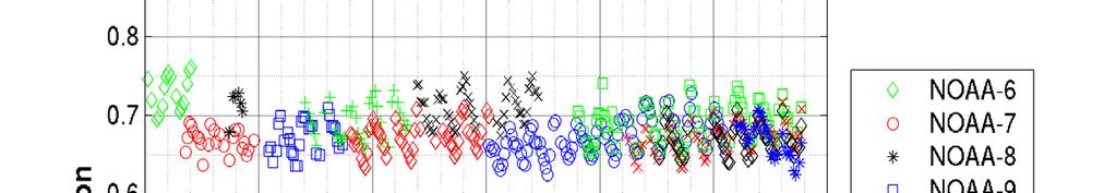
37 N14 thru N16

38 N14 thru N17

39 N14 thru N17


40 Jan 2003

41 N14 N15 for Jan 2003

42 N14 N15 for Jan 2003


43 Land plus Ocean
44 CALIPSO Cloud Trends


45 HIRS CALIPSO
46
47 UW HIRS global cloud statistics from December 1978 through December 2009 All Clouds Thin Clouds NE<0.5 Thick Clouds Opaque Clouds NE>0.95 IR Optical Depth 0.1< <0.7 <3 >3 High (<440 hpa) 40% 22% 15% 3% Mid ( hpa) 12% 5% 6% 1% Low (>680 hpa) 21% 1% 2% 18% All Clouds 73% 28% 23% 22%
48 UW HIRS global cloud statistics from December 1978 through December 2009 (corrected for higher cloud obstruction of lower clouds using random overlap assumption) All Clouds Thin Clouds NE<0.5 Thick Clouds Opaque Clouds NE>0.95 IR Optical Depth 0.1< <0.7 <3 >3 High (<440 hpa) 40% 22% 15% 3% Mid ( hpa) 20% 8% 10% 2% Low (>680 hpa) 52% 2% 5% 45% Clear 27%
49 Combining Imager and Sounder Measurements

50 AVHRR derived cloud trends Next is combining HIRS and AVHRR


51 N10 thru N17
52 Summary * algorithm adjustments tested with MODIS, halving CO2 slicing threshold, spectral shifts suggested by AIRS, CO2 ramp, stratospheric intrusions, are producing consistent HIRS/2 to HIRS/3 results * clouds were found in ~80% (55%) of HIRS observations over ocean (land) since 1995; hi clouds were found in ~40% (33%) over ocean (land) * two year comparison with CALIPSO shows HIRS is finding most of the high clouds and missing more than 5% of all clouds * reprocessing of complete HIRS archive with adjusted algorithm using calibration adjustments suggested by SNOs is underway; merging with AVHRR planned * combined cloud top property retrievals from high spatial and high spectral radiance measurements are still being investigated
Inferring Global Cloud Cover Properties and Trends from 30 years of HIRS Data
 Inferring Global Cloud Cover Properties and Trends from 30 years of HIRS Data W. Paul Menzel a, Erik Olson a, Utkan Kolat a, Elisabeth Weisz a, Robert Holz a, Bryan Baum a, Andrew Heidinger b, Michael
Inferring Global Cloud Cover Properties and Trends with three decades of HIRS Data
 Inferring Global Cloud Cover Properties and Trends with three decades of HIRS Data W. Paul Menzel a, Erik Olson a, Bryan Baum a, Don Wylie a, Utkan Kolat a, Darren L. Jackson b and John J. Bates c a Cooperative
Using 22 years of HIRS Observations to Infer Global Cloud Trends
 Using 22 years of HIRS Observations to Infer Global Cloud Trends Abstract W. Paul Menzel a, Donald P. Wylie b, Darren L. Jackson c, and John J. Bates d a Office of Research and Applications, NOAA / NESDIS,
Very high cloud detection in more than two decades of HIRS data
 JOURNAL OF GEOPHYSICAL RESEARCH: ATMOSPHERES, VOL. 118, 3278 3284, doi:10.1029/2012jd018496, 2013 Very high cloud detection in more than two decades of HIRS data Utkan Kolat, 1 W. Paul Menzel, 1 Erik Olson,
Trends in Global Cloud Cover in Two Decades of HIRS Observations
 1AUGUST 2005 WYLIE ET AL. 3021 Trends in Global Cloud Cover in Two Decades of HIRS Observations DONALD WYLIE Space Science and Engineering Center, University of Wisconsin Madison, Madison, Wisconsin DARREN
MODIS Cloud-Top Property Refinements for Collection 6
 JUNE 2012 B A U M E T A L. 1145 MODIS Cloud-Top Property Refinements for Collection 6 BRYAN A. BAUM, W.PAUL MENZEL, RICHARD A. FREY, DAVID C. TOBIN, ROBERT E. HOLZ, AND STEVE A. ACKERMAN Space Science
Assessment of Global Cloud Climatologies from Satellite Observations
 Assessment of Global Cloud Climatologies from Satellite Observations Claudia Stubenrauch IPSL - Laboratoire de Météorologie Dynamique, France + input from participants of GEWEX Cloud Assessment October
CLOUD TOP PROPERTIES AND CLOUD PHASE ALGORITHM THEORETICAL BASIS DOCUMENT COLLECTION 006 UPDATE
 CLOUD TOP PROPERTIES AND CLOUD PHASE ALGORITHM THEORETICAL BASIS DOCUMENT COLLECTION 006 UPDATE W. Paul Menzel Space Science and Engineering Center University of Wisconsin Madison Richard A. Frey Cooperative
Sensitivity Study of the MODIS Cloud Top Property
 Sensitivity Study of the MODIS Cloud Top Property Algorithm to CO 2 Spectral Response Functions Hong Zhang a*, Richard Frey a and Paul Menzel b a Cooperative Institute for Meteorological Satellite Studies,
Steve Ackerman, R. Holz, R Frey, S. Platnick, A. Heidinger, and a bunch of others.
 Steve Ackerman, R. Holz, R Frey, S. Platnick, A. Heidinger, and a bunch of others. Outline Using CALIOP to Validate MODIS Cloud Detection, Cloud Height Assignment, Optical Properties Clouds and Surface
The MODIS Cloud Data Record
 The MODIS Cloud Data Record Brent C. Maddux 1,2 Steve Platnick 3, Steven A. Ackerman 1 Paul Menzel 1, Kathy Strabala 1, Richard Frey 1, 1 Cooperative Institute for Meteorological Satellite Studies, 2 Department
Global Moderate Resolution Imaging Spectroradiometer (MODIS) cloud detection and height evaluation using CALIOP
 cloud detection and height evaluation using CALIOP") JOURNAL OF GEOPHYSICAL RESEARCH, VOL. 113,, doi:10.1029/2008jd009837, 2008 Global Moderate Resolution Imaging Spectroradiometer (MODIS) cloud detection and height evaluation using CALIOP R. E. Holz, 1
JOURNAL OF GEOPHYSICAL RESEARCH, VOL. 113,, doi:10.1029/2008jd009837, 2008 Global Moderate Resolution Imaging Spectroradiometer (MODIS) cloud detection and height evaluation using CALIOP R. E. Holz, 1
ALGORITHM MAINTENANCE AND VALIDATION OF MODIS CLOUD MASK, CLOUD TOP-PRESSURE, CLOUD PHASE AND ATMOSPHERIC SOUNDING ALGORITHMS
 ALGORITHM MAINTENANCE AND VALIDATION OF MODIS CLOUD MASK, CLOUD TOP-PRESSURE, CLOUD PHASE AND ATMOSPHERIC SOUNDING ALGORITHMS CIMSS Investigators: S. A. Ackerman (PI) W. P. Menzel E. Borbas R. Frey B.
Final Report: NASA Award Number, NNX07AR95G, entitled, COMPARISON OF A - TRAIN CLOUD RETRIEVALS AND MULTI-INSTRUMENT ALGORITHM STUDIES.
 Final Report: NASA Award Number, NNX07AR95G, entitled, COMPARISON OF A - TRAIN CLOUD RETRIEVALS AND MULTI-INSTRUMENT ALGORITHM STUDIES. For the period of August 15, 2007 August 14, 2010 Principal Investigator:
CORRELATION BETWEEN ATMOSPHERIC COMPOSITION AND VERTICAL STRUCTURE AS MEASURED BY THREE GENERATIONS OF HYPERSPECTRAL SOUNDERS IN SPACE
 CORRELATION BETWEEN ATMOSPHERIC COMPOSITION AND VERTICAL STRUCTURE AS MEASURED BY THREE GENERATIONS OF HYPERSPECTRAL SOUNDERS IN SPACE Nadia Smith 1, Elisabeth Weisz 1, and Allen Huang 1 1 Space Science
Journal of the Meteorological Society of Japan, Vol. 75, No. 1, pp , Day-to-Night Cloudiness Change of Cloud Types Inferred from
 Journal of the Meteorological Society of Japan, Vol. 75, No. 1, pp. 59-66, 1997 59 Day-to-Night Cloudiness Change of Cloud Types Inferred from Split Window Measurements aboard NOAA Polar-Orbiting Satellites
CLAVR-x is the Clouds from AVHRR Extended Processing System. Responsible for AVHRR cloud products and other products at various times.
 CLAVR-x in CSPP Andrew Heidinger, NOAA/NESDIS/STAR, Madison WI Nick Bearson, SSEC, Madison, WI Denis Botambekov, CIMSS, Madison, WI Andi Walther, CIMSS, Madison, WI William Straka III, CIMSS, Madison,
Updates to the IMAPP AIRS Utility Software
 SPACE SCIENCE AND ENGINEERING CENTER Updates to the IMAPP AIRS Utility Software Elisabeth Weisz, Hung-Lung Huang and Kathy Strabala Cooperative Institute for Meteorological Satellite Studies Space Science
Assimilation of Cloud-Affected Infrared Radiances at Environment-Canada
 Assimilation of Cloud-Affected Infrared Radiances at Environment-Canada ECMWF-JCSDA Workshop on Assimilating Satellite Observations of Clouds and Precipitation into NWP models ECMWF, Reading (UK) Sylvain
Characterizing the Impact of Hyperspectral Infrared Radiances near Clouds on Global Atmospheric Analyses
 Characterizing the Impact of Hyperspectral Infrared Radiances near Clouds on Global Atmospheric Analyses Will McCarty NASA Session 9a: Assimilation Studies Clouds ITSC-XIX Jeju Island, South Korea 28 March
STRATOSPHERIC TEMPERATURE MONITORING USING A COLLOCATED IR/ GPSRO DATASET
 STRATOSPHERIC TEMPERATURE MONITORING USING A COLLOCATED IR/ GPSRO DATASET Robert Knuteson, Michelle Feltz, Dave Tobin, Dan DeSlover, Hank Revercomb, and Steve Ackerman Uni. of Wisconsin- Madison Space
Comparison of NASA AIRS and MODIS Land Surface Temperature and Infrared Emissivity Measurements from the EOS AQUA platform
 Comparison of NASA AIRS and MODIS Land Surface Temperature and Infrared Emissivity Measurements from the EOS AQUA platform Robert Knuteson, Steve Ackerman, Hank Revercomb, Dave Tobin University of Wisconsin-Madison
EFFECTS OF SPECTRAL RESPONSE FUNCTION DIFFERENCES ON CO 2 SLICING WITH AN APPLICATION TO CLOUD CLIMATOLOGIES. Mark Allen Smalley.
 EFFECTS OF SPECTRAL RESPONSE FUNCTION DIFFERENCES ON CO 2 SLICING WITH AN APPLICATION TO CLOUD CLIMATOLOGIES by Mark Allen Smalley A thesis submitted in partial fulfillment of the requirements for the
APPLICATIONS WITH METEOROLOGICAL SATELLITES. W. Paul Menzel. Office of Research and Applications NOAA/NESDIS University of Wisconsin Madison, WI
 APPLICATIONS WITH METEOROLOGICAL SATELLITES by W. Paul Menzel Office of Research and Applications NOAA/NESDIS University of Wisconsin Madison, WI July 2004 Unpublished Work Copyright Pending TABLE OF CONTENTS
Feature-tracked 3D Winds from Satellite Sounders: Derivation and Impact in Global Models
 Feature-tracked 3D Winds from Satellite Sounders: Derivation and Impact in Global Models David Santek, Anne-Sophie Daloz 1, Samantha Tushaus 1, Marek Rogal 1, Will McCarty 2 1 Space Science and Engineering
An Overview of the UW Hyperspectral Retrieval System for AIRS, IASI and CrIS
 An Overview of the UW Hyperspectral Retrieval System for AIRS, IASI and CrIS Nadia Smith a, Elisabeth Weisz b and William L. Smith Cooperative Institute for Meteorological Satellite Studies (CIMSS) Space
Inter-satellite Calibration of NOAA HIRS Level-1b Data for the Development of Climate Data Records
 Inter-satellite Calibration of NOAA Level-1b Data for the Development of Climate Data Records Ruiyue (Roy) Chen 1, Changyong Cao 2, and Paul Menzel 3 1 I.M. System Group at NOAA/NESDIS/STAR 2 NOAA/NESDIS/STAR
Using HIRS Observations to Construct Long-Term Global Temperature and Water Vapor Profile Time Series
 Using HIRS Observations to Construct Long-Term Global Temperature and Water Vapor Profile Time Series Lei Shi and John J. Bates National Climatic Data Center, National Oceanic and Atmospheric Administration
Satellite data assimilation for Numerical Weather Prediction II
 Satellite data assimilation for Numerical Weather Prediction II Niels Bormann European Centre for Medium-range Weather Forecasts (ECMWF) (with contributions from Tony McNally, Jean-Noël Thépaut, Slide
Development of a System for Quantitatively Analyzing Volcanic Clouds
 Development of a System for Quantitatively Analyzing Volcanic Clouds Michael Pavolonis (NOAA/NESDIS/STAR) Justin Sieglaff and John Cintineo (UW-CIMSS) Marco Fulle - www.stromboli.net 2 nd IUGG-WMO Workshop
NOAA MSU/AMSU Radiance FCDR. Methodology, Production, Validation, Application, and Operational Distribution. Cheng-Zhi Zou
 NOAA MSU/AMSU Radiance FCDR Methodology, Production, Validation, Application, and Operational Distribution Cheng-Zhi Zou NOAA/NESDIS/Center for Satellite Applications and Research GSICS Microwave Sub-Group
DERIVING ATMOSPHERIC MOTION VECTORS FROM AIRS MOISTURE RETRIEVAL DATA
 DERIVING ATMOSPHERIC MOTION VECTORS FROM AIRS MOISTURE RETRIEVAL DATA David Santek 1, Sharon Nebuda 1, Christopher Velden 1, Jeff Key 2, Dave Stettner 1 1 Cooperative Institute for Meteorological Satellite
Combining Polar Hyper-spectral and Geostationary Multi-spectral Sounding Data A Method to Optimize Sounding Spatial and Temporal Resolution
 Combining Polar Hyper-spectral and Geostationary Multi-spectral Sounding Data A Method to Optimize Sounding Spatial and Temporal Resolution W. L. Smith 1,2, E. Weisz 1, and J. McNabb 2 1 University of
Applications of the SEVIRI window channels in the infrared.
 Applications of the SEVIRI window channels in the infrared jose.prieto@eumetsat.int SEVIRI CHANNELS Properties Channel Cloud Gases Application HRV 0.7 Absorption Scattering
Spaceborne Hyperspectral Infrared Observations of the Cloudy Boundary Layer
 Spaceborne Hyperspectral Infrared Observations of the Cloudy Boundary Layer Eric J. Fetzer With contributions by Alex Guillaume, Tom Pagano, John Worden and Qing Yue Jet Propulsion Laboratory, JPL KISS
Satellite Radiance Data Assimilation at the Met Office
 Satellite Radiance Data Assimilation at the Met Office Ed Pavelin, Stephen English, Brett Candy, Fiona Hilton Outline Summary of satellite data used in the Met Office NWP system Processing and quality
GIFTS SOUNDING RETRIEVAL ALGORITHM DEVELOPMENT
 P2.32 GIFTS SOUNDING RETRIEVAL ALGORITHM DEVELOPMENT Jun Li, Fengying Sun, Suzanne Seemann, Elisabeth Weisz, and Hung-Lung Huang Cooperative Institute for Meteorological Satellite Studies (CIMSS) University
Impact of assimilating the VIIRS-based CrIS cloudcleared radiances on hurricane forecasts
 Impact of assimilating the VIIRS-based CrIS cloudcleared radiances on hurricane forecasts Jun Li @, Pei Wang @, Jinlong Li @, Zhenglong Li @, Jung-Rim Lee &, Agnes Lim @, Timothy J. Schmit #, and Mitch
RTTOV 10 Theory & Exercise
 RTTOV 10 Theory & Exercise Ø Overview of RTTOVS Radiative Transfer Model q Gases Absorption (water Vapor & other trace gases) q Aerosol/Clouds Scattering and Absorption q Surface Emissivity/Reflectivity
OBSERVING SYSTEM EXPERIMENTS ON ATOVS ORBIT CONSTELLATIONS
 OBSERVING SYSTEM EXPERIMENTS ON ATOVS ORBIT CONSTELLATIONS Enza Di Tomaso and Niels Bormann European Centre for Medium-range Weather Forecasts Shinfield Park, Reading, RG2 9AX, United Kingdom Abstract
AIRS and IASI Precipitable Water Vapor (PWV) Absolute Accuracy at Tropical, Mid-Latitude, and Arctic Ground-Truth Sites
 Absolute Accuracy at Tropical, Mid-Latitude, and Arctic Ground-Truth Sites") AIRS and IASI Precipitable Water Vapor (PWV) Absolute Accuracy at Tropical, Mid-Latitude, and Arctic Ground-Truth Sites Robert Knuteson, Sarah Bedka, Jacola Roman, Dave Tobin, Dave Turner, Hank Revercomb
AIRS and IASI Precipitable Water Vapor (PWV) Absolute Accuracy at Tropical, Mid-Latitude, and Arctic Ground-Truth Sites Robert Knuteson, Sarah Bedka, Jacola Roman, Dave Tobin, Dave Turner, Hank Revercomb
Development of the Multilayer Cloudy Radiative Transfer Model for GOES-R Advanced Baseline Imager (ABI)
") Development of the Multilayer Cloudy Radiative Transfer Model for GOES-R Advanced Baseline Imager (ABI) Bormin Huang, Yong-Keun Lee, and Allen H.-L. Huang CIMSS/SSEC, UW-Madison Mitchell D. Goldberg NOAA
Development of the Multilayer Cloudy Radiative Transfer Model for GOES-R Advanced Baseline Imager (ABI) Bormin Huang, Yong-Keun Lee, and Allen H.-L. Huang CIMSS/SSEC, UW-Madison Mitchell D. Goldberg NOAA
ITSC-16 Conference. May 2008 Using AVHRR radiances analysis for retrieving atmospheric profiles with IASI in cloudy conditions
 ITSC-16 Conference. May 2008 Using AVHRR radiances analysis for retrieving atmospheric profiles with IASI in cloudy conditions Lydie Lavanant MF/DP/CMS/R&D Experimental production at CMS of near-real real
IRFS-2 instrument onboard Meteor-M N2 satellite: measurements analysis
 IRFS-2 instrument onboard Meteor-M N2 satellite: measurements analysis Polyakov A.V., Virolainen Ya.A., Timofeyev Yu.M. SPbSU, Saint-Petersburg, Russia Uspensky A.B., A.N. Rublev, SRC Planeta, Moscow,
CLOUD CLASSIFICATION AND CLOUD PROPERTY RETRIEVAL FROM MODIS AND AIRS
 6.4 CLOUD CLASSIFICATION AND CLOUD PROPERTY RETRIEVAL FROM MODIS AND AIRS Jun Li *, W. Paul Menzel @, Timothy, J. Schmit @, Zhenglong Li *, and James Gurka # *Cooperative Institute for Meteorological Satellite
A high spectral resolution global land surface infrared emissivity database
 A high spectral resolution global land surface infrared emissivity database Eva E. Borbas, Robert O. Knuteson, Suzanne W. Seemann, Elisabeth Weisz, Leslie Moy, and Hung-Lung Huang Space Science and Engineering
On the Satellite Determination of Multilayered Multiphase Cloud Properties. Science Systems and Applications, Inc., Hampton, Virginia 2
 JP1.10 On the Satellite Determination of Multilayered Multiphase Cloud Properties Fu-Lung Chang 1 *, Patrick Minnis 2, Sunny Sun-Mack 1, Louis Nguyen 1, Yan Chen 2 1 Science Systems and Applications, Inc.,
Retrieval Algorithm Using Super channels
 Retrieval Algorithm Using Super channels Xu Liu NASA Langley Research Center, Hampton VA 23662 D. K. Zhou, A. M. Larar (NASA LaRC) W. L. Smith (HU and UW) P. Schluessel (EUMETSAT) Hank Revercomb (UW) Jonathan
Fine atmospheric structure retrieved from IASI and AIRS under all weather conditions
 Fine atmospheric structure retrieved from IASI and AIRS under all weather conditions Daniel K. Zhou 1, William L. Smith 2,3, Allen M. Larar 1, Xu Liu 1, Jonathan P. Taylor 4, Peter Schlüssel 5, L. Larrabee
A 6-year global cloud climatology from the Atmospheric InfraRed Sounder AIRS and a statistical analysis in synergy with CALIPSO and CloudSat
 Atmos. Chem. Phys., 10, 7197 7214, 2010 doi:10.5194/acp-10-7197-2010 Author(s) 2010. CC Attribution 3.0 License. Atmospheric Chemistry and Physics A 6-year global cloud climatology from the Atmospheric
NOAA Report. Hal Bloom Mitch Goldberg NOAA/NESDIS
 NOAA Report Hal Bloom Mitch Goldberg NOAA/NESDIS Summary of Major Events at NESDIS (of interest to ITSC) NOAA/NASA addressing NPOESS Climate Sensors Letter of agreement signed with JAXA on GCOM interagency
Synergistic use of AIRS and MODIS radiance measurements for atmospheric profiling
 Click Here for Full Article GEOPHYSICAL RESEARCH LETTERS, VOL. 35, L21802, doi:10.1029/2008gl035859, 2008 Synergistic use of AIRS and MODIS radiance measurements for atmospheric profiling Chian-Yi Liu,
Summary Remote Sensing Seminar
 Summary Remote Sensing Seminar Lectures at CREST Paul Menzel NOAA/NESDIS/ORA March 2006 Satellite remote sensing of the Earth-atmosphere Observations depend on telescope characteristics (resolving power,
Synergistic Cloud Clearing Using Aqua Sounding and Imaging Infrared Measurements
 Synergistic Cloud Clearing Using Aqua Sounding and Imaging Infrared Measurements H-L Allen Huang, et al. CIMSS/SSEC Univ. of Wisconsin-Madison and William L. Smith, LaRC, NASA Cloud Clearing/Cloud Detection
Global Daytime Distribution of Overlapping Cirrus Cloud from NOAA's Advanced Very High Resolution Radiometer
 Global Daytime Distribution of Overlapping Cirrus Cloud from NOAA's Advanced Very High Resolution Radiometer Andrew K. Heidinger NOAA/NESDIS/Office of Research and Applications Madison, Wisconsin Michael
The Contribution of Locally Generated MTSat-1R Atmospheric Motion Vectors to Operational Meteorology in the Australian Region
 The Contribution of Locally Generated MTSat-1R Atmospheric Motion Vectors to Operational Meteorology in the Australian Region John Le Marshall Director, JCSDA 2004-2007 CAWCR 2007-2008 J. Le Marshall,
A comparison of cloud top heights computed from airborne lidar and MAS radiance data using CO 2 slicing
 JOURNAL OF GEOPHYSICAL RESEARCH, VOL. 104, NO. D20, PAGES 24,547 24,555, OCTOBER 27, 1999 A comparison of cloud top heights computed from airborne lidar and MAS radiance data using CO 2 slicing Richard
COMPARISON OF AMV CLOUD TOP PRESSURE DERIVED FROM MSG WITH SPACE BASED LIDAR OBSERVATIONS (CALIPSO)
") COMPARISON OF AMV CLOUD TOP PRESSURE DERIVED FROM MSG WITH SPACE BASED LIDAR OBSERVATIONS (CALIPSO) Geneviève Sèze, Stéphane Marchand, Jacques Pelon and Régis Borde 1LMD/IPSL, Paris, France 2 EUMETSAT,
COMPARISON OF AMV CLOUD TOP PRESSURE DERIVED FROM MSG WITH SPACE BASED LIDAR OBSERVATIONS (CALIPSO) Geneviève Sèze, Stéphane Marchand, Jacques Pelon and Régis Borde 1LMD/IPSL, Paris, France 2 EUMETSAT,
P4.23 INTRODUCING THE GOES IMAGER CLEAR-SKY BRIGHTNESS TEMPERATURE (CSBT) PRODUCT
 PRODUCT") P4.23 INTRODUCING THE GOES IMAGER CLEAR-SKY BRIGHTNESS TEMPERATURE (CSBT) PRODUCT Anthony J. Schreiner Cooperative Institute for Meteorological Satellite Studies (CIMSS) University of Wisconsin-Madison
P4.23 INTRODUCING THE GOES IMAGER CLEAR-SKY BRIGHTNESS TEMPERATURE (CSBT) PRODUCT Anthony J. Schreiner Cooperative Institute for Meteorological Satellite Studies (CIMSS) University of Wisconsin-Madison
CLOUD MOTION WINDS FROM FY-2 AND GMS-5 METEOROLOGICAL SATELLITES. Xu Jianmin, Zhang Qisong, Fang Xiang, Liu Jian
 CLOUD MOTION WINDS FROM FY-2 AND GMS-5 METEOROLOGICAL SATELLITES Xu Jianmin, Zhang Qisong, Fang Xiang, Liu Jian National Satellite Meteorological Center Abstract Cloud Motion Winds (CMW) from FY-2 and
Global Soundings of the Atmosphere from ATOVS Measurements: The Algorithm and Validation
 1248 JOURNAL OF APPLIED METEOROLOGY Global Soundings of the Atmosphere from ATOVS Measurements: The Algorithm and Validation JUN LI ANDWALTER W. WOLF Cooperative Institute for Meteorological Satellite
Influence of Clouds and Aerosols on the Earth s Radiation Budget Using Clouds and the Earth s Radiant Energy System (CERES) Measurements
 Measurements") Influence of Clouds and Aerosols on the Earth s Radiation Budget Using Clouds and the Earth s Radiant Energy System (CERES) Measurements Norman G. Loeb Hampton University/NASA Langley Research Center Bruce
Influence of Clouds and Aerosols on the Earth s Radiation Budget Using Clouds and the Earth s Radiant Energy System (CERES) Measurements Norman G. Loeb Hampton University/NASA Langley Research Center Bruce
A 6-year global cloud climatology from the Atmospheric InfraRed Sounder AIRS and a statistical analysis in synergy with CALIPSO and CloudSat
 A 6-year global cloud climatology from the Atmospheric InfraRed Sounder AIRS and a statistical analysis in synergy with CALIPSO and CloudSat C. J. Stubenrauch, S. Cros, A. Guignard, N. Lamquin To cite
Effects of GPS/RO refractivities on IR/MW retrievals
 Effects of GPS/RO refractivities on IR/MW retrievals Éva E. Borbás *, W. Paul Menzel **, Jun Li * and Harold M. Woolf * * Space Science and Engineering Center, University of Wisconsin / Madison ** NESDIS/
The NOAA/NESDIS/STAR IASI Near Real-Time Product Processing and Distribution System
 The NOAA/NESDIS/STAR Near Real-Time Product Processing and Distribution System W. Wolf 2, T. King 1, Z. Cheng 1, W. Zhou 1, H. Sun 1, P. Keehn 1, L. Zhou 1, C. Barnet 2, and M. Goldberg 2 1 QSS Group Inc,
Plans for the Assimilation of Cloud-Affected Infrared Soundings at the Met Office
 Plans for the Assimilation of Cloud-Affected Infrared Soundings at the Met Office Ed Pavelin and Stephen English Met Office, Exeter, UK Abstract A practical approach to the assimilation of cloud-affected
Jun Mitch Goldberg %, Pei Timothy J. Schmit &, Jinlong Zhenglong and Agnes
 Progress on the assimilation of advanced IR sounder radiances in cloudy skies Jun Li @, Mitch Goldberg %, Pei Wang @#, Timothy J. Schmit &, Jinlong Li @, Zhenglong Li @, and Agnes Lim @ @CIMSS, University
Methane Sensing Flight of Scanning HIS over Hutchinson, KS, 31 March 2001
 Methane Sensing Flight of Scanning HIS over Hutchinson, KS, 31 March 2001 Hank Revercomb, Chris Moeller, Bob Knuteson, Dave Tobin, Ben Howell University of Wisconsin, Space Science and Engineering Center
MODIS ATMOSPHERIC PROFILES PRODUCT IN FINLAND A FEASIBILITY STUDY
 MODIS ATMOSPHERIC PROFILES PRODUCT IN FINLAND A FEASIBILITY STUDY Sauli Joro Finnish Meteorological Institute P.O.Box 503, FIN-00101 Helsinki, FINLAND sauli.joro@fmi.fi ABSTRACT The prediction of convection
Reprocessed Satellite Data Products for Assimilation and Validation
 Reprocessed Satellite Data Products for Assimilation and Validation Leo van de Berg, Bertrand Theodore EUMETSAT Page 1 Historical Presentation Contents Results of Eumetsat ERA-40 Activities Lessons Learned
EUMETSAT Satellite Data Records for Reanalysis
 EUMETSAT Satellite Data Records for Reanalysis Jörg Schulz, Tim Hewison, Rob Roebeling, Roger Huckle Acknowledgements: Julia Figa, Christian Marquardt, Rüdiger Lang, Lothar Schüller, Bertrand Theodore
Aircraft Validation of Infrared Emissivity derived from Advanced InfraRed Sounder Satellite Observations
 Aircraft Validation of Infrared Emissivity derived from Advanced InfraRed Sounder Satellite Observations Robert Knuteson, Fred Best, Steve Dutcher, Ray Garcia, Chris Moeller, Szu Chia Moeller, Henry Revercomb,
The Use of Hyperspectral Infrared Radiances In Numerical Weather Prediction
 The Use of Hyperspectral Infrared Radiances In Numerical Weather Prediction J. Le Marshall 1, J. Jung 1, J. Derber 1, T. Zapotocny 2, W. L. Smith 3, D. Zhou 4, R. Treadon 1, S. Lord 1, M. Goldberg 1 and
JCSDA EXPERIMENTS IN THE USE OF RADIANCES IN NUMERICAL WEATHER PREDICTION
 JCSDA EXPERIMENTS IN THE USE OF RADIANCES IN NUMERICAL WEATHER PREDICTION J. Le Marshall, J. Jung, T. Zapotocny, W. L. Smith, D. Zhou, J. Derber, R. Treadon, S. Lord, M. Goldberg and W. Wolf JCSDA Partners
Long-term time-series of height-resolved ozone for nadir-uv spectrometers: CCI and beyond
 Long-term time-series of height-resolved ozone for nadir-uv spectrometers: CCI and beyond Richard Siddans, Georgina Miles, Barry Latter, Brian Kerridge RAL Earth Observation & Atmospheric Science Division,
AMVs in the ECMWF system:
 AMVs in the ECMWF system: Overview of the recent operational and research activities Kirsti Salonen and Niels Bormann Slide 1 AMV sample coverage: monitored GOES-15 GOES-13 MET-10 MET-7 MTSAT-2 NOAA-15
Application of the UW/CIMSS high spectral resolution global IR land surface emissivity database into the RTTOV model
 Application of the UW/CIMSS high spectral resolution global IR land surface emissivity database into the RTTOV model Eva Borbas 1, Ben Ruston 2, Roger Saunders 3, Andrew Collard 3, Robert Knuteson 1, James
Bias Correction of Satellite Data at NCEP
 Bias Correction of Satellite Data at NCEP Paul van Delst 1, John Derber 2, Russ Treadon 2, Kozo Okamoto 3 and Wan-Shu Wu 2 1 CIMSS @ NOAA/NWS/NCEP/EMC, 2 NOAA/NWS/NCEP/EMC 3 JMA visiting scientist @ NOAA/NWS/NCEP/EMC
A two-season impact study of the Navy s WindSat surface wind retrievals in the NCEP global data assimilation system
 A two-season impact study of the Navy s WindSat surface wind retrievals in the NCEP global data assimilation system Li Bi James Jung John Le Marshall 16 April 2008 Outline WindSat overview and working
Developments in CALIOP Aerosol Products. Dave Winker
 Developments in CALIOP Aerosol Products Dave Winker NASA Langley Research Center Hampton, VA Winker - 1 Outline Level 3 aerosol product (beta-version) Version 4 Level 1 product A few CALIOP assimilation
NWP SAF AMV monitoring: the 7th Analysis Report (AR7)
") Document NWPSAF-MO-TR-032 Version 1.0 24/05/16 NWP SAF AMV monitoring: the 7th Analysis Report (AR7) Francis Warrick Met Office, UK NWP SAF AMV monitoring: the 7th Analysis Report (AR7) Francis Warrick
Document NWPSAF-MO-TR-032 Version 1.0 24/05/16 NWP SAF AMV monitoring: the 7th Analysis Report (AR7) Francis Warrick Met Office, UK NWP SAF AMV monitoring: the 7th Analysis Report (AR7) Francis Warrick
Lessons Learned with the AIRS Hyperspectral Sensor. L.Larrabee Strow
 AS and Lessons Learned with the AS Sensor L.Larrabee Strow Atmospheric Spectroscopy Laboratory (ASL) UMBC Physics Department and the Joint Center for Earth Systems Technology April 26, 2006 Thanks to:
Long-Term Time Series of Water Vapour Total Columns from GOME, SCIAMACHY and GOME-2
 Graphics: ESA Graphics: ESA Graphics: ESA Long-Term Time Series of Water Vapour Total Columns from GOME, SCIAMACHY and GOME-2 S. Noël, S. Mieruch, H. Bovensmann, J. P. Burrows Institute of Environmental
Monitoring and Assimilation of IASI Radiances at ECMWF
 Monitoring and Assimilation of IASI Radiances at ECMWF Andrew Collard and Tony McNally ECMWF Slide 1 Overview Introduction Assimilation Configuration IASI First Guess Departures IASI Forecast Impacts The
REPORT FROM THE INTERNATIONAL CLOUDS WORKING GROUP (ICWG)
") Proceedings for the 13 th International Winds Workshop 27 June - 1 July 2016, Monterey, California, USA REPORT FROM THE INTERNATIONAL CLOUDS WORKING GROUP (ICWG) Dong Wu 1, Bryan Baum 2, Andrew Heidinger
Proceedings for the 13 th International Winds Workshop 27 June - 1 July 2016, Monterey, California, USA REPORT FROM THE INTERNATIONAL CLOUDS WORKING GROUP (ICWG) Dong Wu 1, Bryan Baum 2, Andrew Heidinger
Final status report.
 Cloud Assessment Final status report Coordinators: Claudia Stubenrauch Laboratoire de Météorologie Dynamique, IPSL/CNRS, France Stefan Kinne Max Planck Institute for Meteorology, Hamburg, Germany http://climserv.ipsl.polytechnique.fr/gewexca
THE POLAR WIND PRODUCT SUITE
 THE POLAR WIND PRODUCT SUITE Jeffrey Key 1, David Santek 2, Christopher Velden 2, Jaime Daniels 1, Richard Dworak 2 1 Center for Satellite Applications and Research, NOAA/NESDIS 2 Cooperative Institute
HYSPLIT volcanic ash dispersion modeling R&D, NOAA NWS NCEP operations, and transfer to operations
 HYSPLIT volcanic ash dispersion modeling R&D, NOAA NWS NCEP operations, and transfer to operations Barbara Stunder 1, Alice Crawford 1,2, Tianfeng Chai 1,2, Michael Pavolonis 3 1 NOAA OAR Air Resources
Antarctic Cloud Radiative Forcing at the Surface Estimated from the AVHRR Polar Pathfinder and ISCCP D1 Datasets,
 JUNE 2003 PAVOLONIS AND KEY 827 Antarctic Cloud Radiative Forcing at the Surface Estimated from the AVHRR Polar Pathfinder and ISCCP D1 Datasets, 1985 93 MICHAEL J. PAVOLONIS Cooperative Institute for
COMPARISON OF SIMULATED RADIANCE FIELDS USING RTTOV AND CRTM AT MICROWAVE FREQUENCIES IN KOPS FRAMEWORK
 COMPARISON OF SIMULATED RADIANCE FIELDS USING RTTOV AND CRTM AT MICROWAVE FREQUENCIES IN KOPS FRAMEWORK Ju-Hye Kim 1, Jeon-Ho Kang 1, Hyoung-Wook Chun 1, and Sihye Lee 1 (1) Korea Institute of Atmospheric
An Evaluation of FY-3C MWHS-2 and its potential to improve forecast accuracy at ECMWF
 An Evaluation of FY-3C MWHS-2 and its potential to improve forecast accuracy at ECMWF Heather Lawrence, final-year EUMETSAT fellow, ECMWF Supervised by: Niels Bormann & Stephen English Slide 1 China s
ASSESSING THE QUALITY OF HISTORICAL AVHRR POLAR WIND HEIGHT ASSIGNMENT
 ASSESSING THE QUALITY OF HISTORICAL AVHRR POLAR WIND HEIGHT ASSIGNMENT Richard Dworak + and Jeff Key* + Cooperative Institute for Meteorological Satellite Studies (CIMSS), University of Wisconsin Madison,
Generation and Initial Evaluation of a 27-Year Satellite-Derived Wind Data Set for the Polar Regions NNX09AJ39G. Final Report Ending November 2011
 Generation and Initial Evaluation of a 27-Year Satellite-Derived Wind Data Set for the Polar Regions NNX09AJ39G Final Report Ending November 2011 David Santek, PI Space Science and Engineering Center University
VALIDATION OF DUAL-MODE METOP AMVS
 VALIDATION OF DUAL-MODE METOP AMVS Ákos Horváth 1, Régis Borde 2, and Hartwig Deneke 1 1 Leibniz Institute for Tropospheric Research, Permoserstrasse 15, Leipzig, Germany 2 EUMETSAT, Eumetsat Allee 1,
Comparison of NASA AIRS and MODIS Land Surface Temperature and Infrared Emissivity Measurements from the EOS AQUA platform
 Comparison of NASA AIRS and MODIS Land Surface Temperature and Infrared Emissivity Measurements from the EOS AQUA platform Robert Knuteson, Hank Revercomb, Dave Tobin University of Wisconsin-Madison 16
Cloud detection for IASI/AIRS using imagery
 Cloud detection for IASI/AIRS using imagery Lydie Lavanant* Mohamed Dahoui** Florence Rabier***, Thomas Auligné*** * Météo-France/DP/CMS/R&D ** Moroccan Meterological Service. NWPSAF Visiting Scientist
Examining effect of Asian dusts on the AIRS-measured radiances from radiative transfer simulations
 Examining effect of Asian dusts on the AIRS-measured radiances from radiative transfer simulations Hyo-Jin Han 1, B.J. Sohn 1 Allen Huang 2, Elisabeth Weisz 2 1 School of Earth and Environmental Sciences
Polar winds from highly elliptical orbiting satellites: a new perspective
 Polar winds from highly elliptical orbiting satellites: a new perspective 10 th International Winds Workshop Tokyo, Japan, Feb -6, 010 L. Garand 1, N. Wagneur 1, R. Sarrazin 1, D. Santek, J. Key 1 Environment
An update on the NOAA MSU/AMSU CDR development
 An update on the NOAA MSU/AMSU CDR development Cheng-Zhi Zou NOAA/NESDIS/Center for Satellite Applications and Research International TOVS Study Conferences (ITSC), Monterey, CA, April 14-20, 2010 1 Outline
An Overview of Atmospheric Analyses and Reanalyses for Climate
 An Overview of Atmospheric Analyses and Reanalyses for Climate Kevin E. Trenberth NCAR Boulder CO Analysis Data Assimilation merges observations & model predictions to provide a superior state estimate.