An overview of Wet Season Forecasting in the Northern Territory
|
|
|
- Katrina Hunt
- 5 years ago
- Views:
Transcription
1 TWP-ICE Meeting November 2004 An overview of Wet Season Forecasting in the Northern Territory Lori Chappel Northern Territory Regional Forecasting Centre Australian Government Bureau of Meteorology
2 Day 1. Monday Nov. 15, 2004 Session 1. Science Overview, forecast issues and satellites (Chair Jim Mather) 830 Welcome Jim Arthur (Regional Director, Forecast Office) 835 Welcome, aims of meeting Tom Ackerman (PNNL, ARM) 845 Science goals overview Peter May (BMRC) Eric Jensen (NASA) Cornelius Schiller (SCOUT) 915 The Australian monsoon Peter May (BMRC) Sam Cleland 945 Weather forecasting in Darwin during the wet season: (NTRO) Techniques and performance Lori Chappel (NTRO, BoM) Tools available for forecasting Lori Chappel 1015 MORNING TEA 1045 Discussion of forecast issues and meteorology led by Ed Zipser Forecasting setup for the experiment Chappel/Jakob What ECMWF products are required? Tools radar, satellite, NWP displays, soundings Briefings Times, location, content what is required?
3 An overview of Wet Season Forecasting in the Northern Territory Functions of the NT region; Weather expectations; Tropical forecasting tools; Forecast performance;
4 Overview of Northern Territory Regional Office - Darwin RSMC Regional Specialised Meteorological Centre RFC Regional Forecasting Centre Volcanic Ash Advisory Centre Severe Weather Section Climate Section
5 Climate Section Weekly Tropical Climate Note expertise in MJO interpretation, easterly waves Climate forecasts are woven into forecasting policy Darwin Tropical Diagnostic Statement
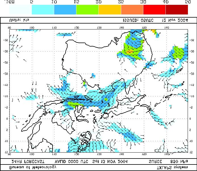
6 RSMC Area of coverage E, 25N-25S Products hand drawn analysis gradient level and 200 hpa current warnings TC and gale TC paobs for models TLAPS products (TXLAPS)
7
8
9 Darwin Regional Forecasting Centre (RFC) Aviation, Marine and Public Weather forecasts for Northern Territory (and some WA Kimberly); 24 hour coverage; ½ hrly TTF (trend type forecast) for Darwin Airport 5am 9pm; Conservative TAF policy during the wet pick the certain good weather breaks 7am forecasting and shift handover ideal for daily briefing

10 YPDN TAF holding
11 Percentage of days with holding at each hour YPDN TAF January and February Percentage of days Series Hour (06-06) UTC
12 YPDN TAF 13/24 hours average holding Jan/Feb 04 (06-06) Peak holding period 3-7am
13 YPDN TAF / / / /04 POD FAR
14 Darwin Airport Climate Statistics Month Max Temp Min Temp Rain Days Rain average (mm) Days with Fog Days with thunder Jan/Feb /361 Nil/0.1 19
15 Darwin Airport Alternate Minima YPDN Elevation 103ft Navaids VOR,DME,GPS Category Special A, B C D Cloud Base(ft) Visibility (m)

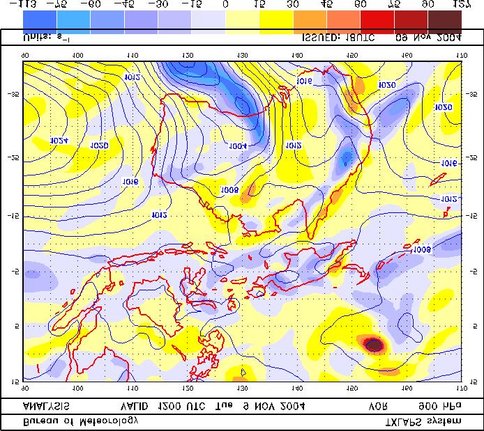
16 850 hpa Jan/Feb

17 700 hpa Jan/Feb

18 200 hpa Jan/Feb
19 Darwin Airport observations Sounding twice daily 11Z, and 23Z. Upper winds 6 hourly; ½ hourly METARS over 24 hours
20
21 Severe Weather Section TCWC tropical cyclone warning centre for Timor Sea, Arafura Sea and western Gulf of Carpentaria. 24 hours TC roster when required; Severe Storm Warning Service for Darwin area within 60km.

22 Darwin TCWC Area
23

24
25
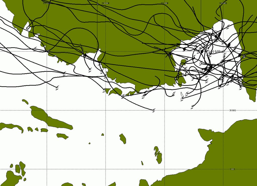
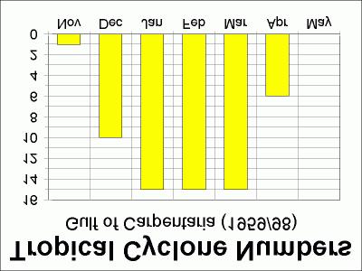
26 Tropical Cyclones Total 18 cyclones over 40 year period ( ) affected Darwin and TWP-ICE experiment area (Tiwi Islands, Coburg Peninsular, eastern Timor Sea) Lowest TC probability month in February 3% probability of getting TC in area in Feb 8% probability of getting TC in area in Jan
27 Darwin Severe Thunderstorm Area
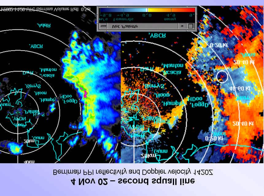
28 Darwin Severe Thunderstorms Wind gusts main severe phenomena; Continental Squall lines warned for usually a couple per season ; Also can get severe monsoon squalls several prone days per season, pulse downburst storms up to 20 days per season but rare on coast/airport;
29
30

31 CAPE vs Shear

32 CAPE vs Convective Gust
33
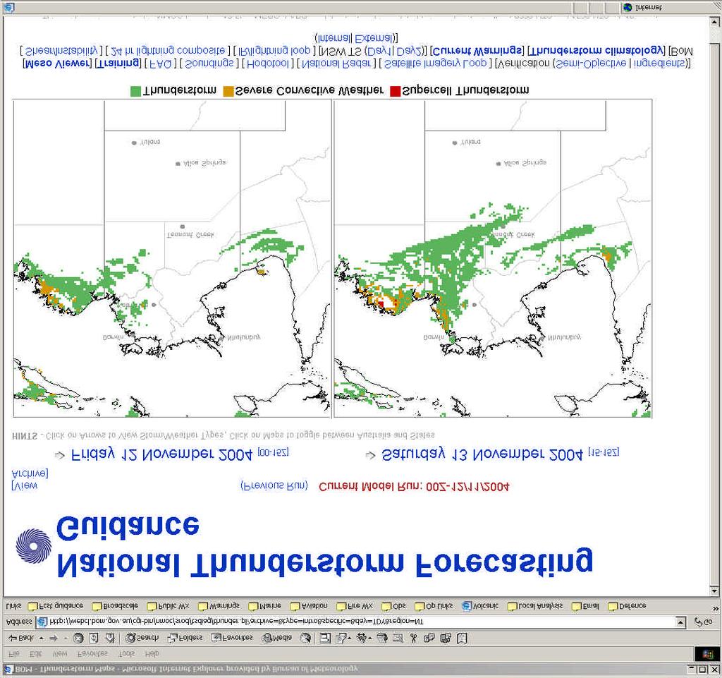
34 Forecasting tools Monsoon on-set < 1 week forecast MJO and easterly waves NWP wind/surge,moisture and vorticity fields; Satellite imagery; Break Season Convective Analysis NTFGS - National Thunderstorm Forecasting Guidance MesoLAPS NWP 5km TITAN, WDSS
35 Forecasting tools Extra-tropical interactions mid-lat troughs surges in the easterlies Water Vapour imagery dry air/ upper trough
36 Spin-offs for Tropical Forecasting Will extra observations and soundings improve model performance and forecasting in the tropics? In particular moisture field; Aim to improve 0-6/12 hour forecasting ability (convection).
Activity Report for Australian TCWCs 2009/2012
 Activity Report for Australian TCWCs 2009/2012 7th RSMC/TCWC Co-ordination Meeting Citeko, November 2012 Mike Bergin Regional Director (Western Australia) Bureau of Meteorology Outline Significant Cyclones
Thai Meteorological Department, Ministry of Digital Economy and Society
 Thai Meteorological Department, Ministry of Digital Economy and Society Three-month Climate Outlook For November 2017 January 2018 Issued on 31 October 2017 -----------------------------------------------------------------------------------------------------------------------------
Weather and Climate Basics
 Aims of this presentation Weather and Climate Basics To describe what I do as a forecaster at the Bureau of Meteorology Laura Boekel Forecaster at Bureau of Meteorology To provide an interesting introduction
Weather and Climate Basics
 Weather and Climate Basics Laura Boekel Forecaster at Bureau of Meteorology Aims of this presentation To describe what I do as a forecaster at the Bureau of Meteorology To provide an interesting introduction
Strategic Radar Enhancement Project (SREP) Forecast Demonstration Project (FDP) The future is here and now
 Forecast Demonstration Project (FDP) The future is here and now") Strategic Radar Enhancement Project (SREP) Forecast Demonstration Project (FDP) The future is here and now Michael Berechree National Manager Aviation Weather Services Australian Bureau of Meteorology
Strategic Radar Enhancement Project (SREP) Forecast Demonstration Project (FDP) The future is here and now Michael Berechree National Manager Aviation Weather Services Australian Bureau of Meteorology
UPDATE OF REGIONAL WEATHER AND SMOKE HAZE (December 2017)
") UPDATE OF REGIONAL WEATHER AND SMOKE HAZE (December 2017) 1. Review of Regional Weather Conditions for November 2017 1.1 In November 2017, Southeast Asia experienced inter-monsoon conditions in the first
UPDATE OF REGIONAL WEATHER AND SMOKE HAZE (December 2017) 1. Review of Regional Weather Conditions for November 2017 1.1 In November 2017, Southeast Asia experienced inter-monsoon conditions in the first
Aviation Hazards: Thunderstorms and Deep Convection
 Aviation Hazards: Thunderstorms and Deep Convection TREND Empirical thunderstorm forecasting techniques Contents Necessary conditions for convection: Instability Low-level moisture Trigger mechanism Forecasting
STATISTICAL STUDY OF CONVECTIVE AVAILABLE POTENTIAL ENERGY AND DAYTIME THUNDERSTORMS IN SINGAPORE. Kar Lin Yap*
 STATISTICAL STUDY OF CONVECTIVE AVAILABLE POTENTIAL ENERGY AND DAYTIME THUNDERSTORMS IN SINGAPORE Kar Lin Yap* Meteorological Service Singapore, Singapore 1. INTRODUCTION The climate of Singapore is warm
1. Introduction. 2. Verification of the 2010 forecasts. Research Brief 2011/ February 2011
 Research Brief 2011/01 Verification of Forecasts of Tropical Cyclone Activity over the Western North Pacific and Number of Tropical Cyclones Making Landfall in South China and the Korea and Japan region
Government of Sultanate of Oman Public Authority of Civil Aviation Directorate General of Meteorology. National Report To
 Government of Sultanate of Oman Public Authority of Civil Aviation Directorate General of Meteorology National Report To Panel on Tropical Cyclones in the Bay of Bengal And Arabian Sea 43rd Session, India
CASE STUDY: Tropical Cyclone Monica, April 2006
 CASE STUDY: Tropical Cyclone Monica, April 2006 By Mr Jeff Callaghan Retired Senior Severe Weather Forecaster, Bureau of Meteorology, Brisbane The track of tropical cyclone Monica (Figure 1) took it from
UPDATE OF REGIONAL WEATHER AND SMOKE HAZE (September 2017)
") UPDATE OF REGIONAL WEATHER AND SMOKE HAZE (September 2017) 1. Review of Regional Weather Conditions in August 2017 1.1 Southwest Monsoon conditions continued to prevail in the region in August 2017. The
UPDATE OF REGIONAL WEATHER AND SMOKE HAZE (September 2017) 1. Review of Regional Weather Conditions in August 2017 1.1 Southwest Monsoon conditions continued to prevail in the region in August 2017. The
GEN 3.5 METEOROLOGICAL SERVICES
 AIP GEN 3.5-1 GEN 3.5 METEOROLOGICAL SERVICES 1. RESPONSIBLE SERVICE The meteorological services for civil aviation at Jordan are provided by the Jordanian Meteorological Department. Postal Address: Director
ECMWF products to represent, quantify and communicate forecast uncertainty
 ECMWF products to represent, quantify and communicate forecast uncertainty Using ECMWF s Forecasts, 2015 David Richardson Head of Evaluation, Forecast Department David.Richardson@ecmwf.int ECMWF June 12,
Issued by the: Climate Services Division Fiji Meteorological Service Nadi Airport. 27 October 2010 GENERAL STATEMENT
 Fiji Meteorological Service (FMS) Tropical Cyclone Guidance for Season 2010/11 for the Fiji and the Southwest Pacific RSMC Region 160E to 120W Equator to 25 South Issued by the: Climate Services Division
Convective-scale NWP for Singapore
 Convective-scale NWP for Singapore Hans Huang and the weather modelling and prediction section MSS, Singapore Dale Barker and the SINGV team Met Office, Exeter, UK ECMWF Symposium on Dynamical Meteorology
COUNTRY REPORT. Jakarta. July, th National Directorate of Meteorology and Geophysics of Timor-Leste (DNMG)
") The Southeastern Asia-Oceania Flash Flood COUNTRY REPORT Jakarta. July, 10-12 th 2017 National Directorate of Meteorology and Geophysics of Timor-Leste (DNMG) Carla Feritas and Crisostimo Lobato Democratic
The Southeastern Asia-Oceania Flash Flood COUNTRY REPORT Jakarta. July, 10-12 th 2017 National Directorate of Meteorology and Geophysics of Timor-Leste (DNMG) Carla Feritas and Crisostimo Lobato Democratic
Aviation Hazards: Thunderstorms and Deep Convection
 Aviation Hazards: Thunderstorms and Deep Convection TREND NWP Products for Thunderstorm Forecasting Contents Model choice Identifying parameters important for convection: Low-level convergence High relative
Sub-seasonal predictions at ECMWF and links with international programmes
 Sub-seasonal predictions at ECMWF and links with international programmes Frederic Vitart and Franco Molteni ECMWF, Reading, U.K. Using ECMWF forecasts, 4-6 June 2014 1 Outline Recent progress and plans
Plan for operational nowcasting system implementation in Pulkovo airport (St. Petersburg, Russia)
") Plan for operational nowcasting system implementation in Pulkovo airport (St. Petersburg, Russia) Pulkovo airport (St. Petersburg, Russia) is one of the biggest airports in the Russian Federation (150
Plan for operational nowcasting system implementation in Pulkovo airport (St. Petersburg, Russia) Pulkovo airport (St. Petersburg, Russia) is one of the biggest airports in the Russian Federation (150
UPDATE OF REGIONAL WEATHER AND SMOKE HAZE (February 2018)
") UPDATE OF REGIONAL WEATHER AND SMOKE HAZE (February 2018) 1. Review of Regional Weather Conditions for January 2018 1.1 The prevailing Northeast monsoon conditions over Southeast Asia strengthened in January
UPDATE OF REGIONAL WEATHER AND SMOKE HAZE (February 2018) 1. Review of Regional Weather Conditions for January 2018 1.1 The prevailing Northeast monsoon conditions over Southeast Asia strengthened in January
AOMSUC-6 Training Event
 Effective use of high temporal and spatial resolution Himawari-8 data AOMSUC-6 Training Event Bodo Zeschke Australian Bureau of Meteorology Training Centre Australian VLab Centre of Excellence Content
AMDAR Forecast Applications. Richard Mamrosh NWS Green Bay, Wisconsin, USA
 AMDAR Forecast Applications Richard Mamrosh NWS Green Bay, Wisconsin, USA AMDAR has many applications Aviation Low level wind shear Ceilings and visibilities Icing and turbulence Winter Storms Precipitation
Tropical Cyclone Forecasting Applications of the GOES WMSI
 1. Introduction Tropical Cyclone Forecasting Applications of the GOES WMSI Kenneth L. Pryor Center for Satellite Applications and Research (NOAA/NESDIS) Camp Springs, MD The Geostationary Operational Environmental
Convective downbursts are known to produce potentially hazardous weather
 Investigation of Convective Downburst Hazards to Marine Transportation Mason, Derek Thomas Jefferson High School for Science and Technology Alexandria, VA Abstract Convective downbursts are known to produce
Issue of SIGMET/AIRMET warning part II
 Issue of SIGMET/AIRMET warning part II 1 SIGMET SIGMET is warning information and hence it is of highest priority amongst other types of meteorological information provided to the aviation users. This
NHC Ocean Vector Winds Update
 NHC Ocean Vector Winds Update Michael J. Brennan NOAA/NWS/NCEP National Hurricane Center International Ocean Vector Winds Science Team Meeting Portland, Oregon, 20 May 2015 Current Status NHC is currently
Isolated severe weather and cold air damming 9 November 2005 By Richard H. Grumm National Weather Service Office State College, PA 16801
 Isolated severe weather and cold air damming 9 November 2005 By Richard H. Grumm National Weather Service Office State College, PA 16801 1. INTRODUCTION Two lines of convection moved over the State of
WEEKEND WEATHER OUTLOOK BELIZE, CENTRAL AMERICA
 WEEKEND WEATHER OUTLOOK BELIZE, CENTRAL AMERICA PERIOD: Friday, July 13 until Monday, July 16, 2012 DATE ISSUED: Friday, June 13, 2012, 9:00 am RFrutos SYNOPSIS: A weak pressure gradient over the NW Caribbean
The benefits and developments in ensemble wind forecasting
 The benefits and developments in ensemble wind forecasting Erik Andersson Slide 1 ECMWF European Centre for Medium-Range Weather Forecasts Slide 1 ECMWF s global forecasting system High resolution forecast
ALASKA REGION CLIMATE OUTLOOK BRIEFING. December 22, 2017 Rick Thoman National Weather Service Alaska Region
 ALASKA REGION CLIMATE OUTLOOK BRIEFING December 22, 2017 Rick Thoman National Weather Service Alaska Region Today s Outline Feature of the month: Autumn sea ice near Alaska Climate Forecast Basics Climate
KUALA LUMPUR MONSOON ACTIVITY CENT
 T KUALA LUMPUR MONSOON ACTIVITY CENT 2 ALAYSIAN METEOROLOGICAL http://www.met.gov.my DEPARTMENT MINISTRY OF SCIENCE. TECHNOLOGY AND INNOVATIO Introduction Atmospheric and oceanic conditions over the tropical
Presentation on RSMC Nadi-TCC Activities
 6 th TC RSMC Technical Coordination Meeting, Brisbane, Australia, 2 5 Nov 2009 Presentation on RSMC Nadi-TCC Activities R. Prasad Director RSMC Nadi-TCC NADI TROPICAL CYCLONE CENTRE RSMC NADI - TCC Approved
Sub-seasonal predictions at ECMWF and links with international programmes
 Sub-seasonal predictions at ECMWF and links with international programmes Frederic Vitart and Franco Molteni ECMWF, Reading, U.K. 1 Outline 30 years ago: the start of ensemble, extended-range predictions
Northeastern United States Snowstorm of 9 February 2017
 Northeastern United States Snowstorm of 9 February 2017 By Richard H. Grumm and Charles Ross National Weather Service State College, PA 1. Overview A strong shortwave produced a stripe of precipitation
Exercise Brunswick ALPHA 2018
 ALPHA Exercise Brunswick ALPHA 2018 Who we are (our structure) What we do (our forecasts) How you can access the information Tropical cyclone information (basic) Overview of the products used for Exercise
Issue of SIGMET/AIRMET warning
 Issue of SIGMET/AIRMET warning 1 Presentation Objectives After this presentation session you will be able to: Warn for Hazardous weather phenomena using the correct ICAO coding with regards to SIGMET/AIRMET
MAURITIUS METEOROLOGICAL SERVICES
 MAURITIUS METEOROLOGICAL SERVICES CLIMATE NOVEMBER 2018 Introduction Climatologically speaking, November is a relatively dry month for Mauritius with a long term monthly mean rainfall of 78 mm. However,
MSG FOR NOWCASTING - EXPERIENCES OVER SOUTHERN AFRICA
 MSG FOR NOWCASTING - EXPERIENCES OVER SOUTHERN AFRICA Estelle de Coning and Marianne König South African Weather Service, Private Bag X097, Pretoria 0001, South Africa EUMETSAT, Am Kavalleriesand 31, D-64295
Aeronautical Information Service
 , St. Maarten and The Netherlands EFFECTIVE DATE: 31 MARCH 2016 KNMI Meteorological Services Information for TNCB, TNCE and TNCS Page: GEN 2.7-1 Sunrise / sunset tables 1. The tables on the following pages
Joint Meeting of RA II WIGOS Project and RA V TT-SU on 11 October 2018 BMKG Headquarter Jakarta, Indonesia. Mrs. Sinthaly CHANTHANA
 Joint Meeting of RA II WIGOS Project and RA V TT-SU on 11 October 2018 BMKG Headquarter Jakarta, Indonesia Mrs. Sinthaly CHANTHANA Lao PDR Background Department of Meteorology and Hydrology ( DMH ) in
UPDATE OF REGIONAL WEATHER AND SMOKE HAZE (May 2017)
") UPDATE OF REGIONAL WEATHER AND SMOKE HAZE (May 2017) 1. Review of Regional Weather Conditions in April 2017 1.1 Inter monsoon conditions, characterised by afternoon showers and winds that are generally
UPDATE OF REGIONAL WEATHER AND SMOKE HAZE (May 2017) 1. Review of Regional Weather Conditions in April 2017 1.1 Inter monsoon conditions, characterised by afternoon showers and winds that are generally
Challenging Aspects of Severe Tropical Cyclone George s s Track Forecasts
 Challenging Aspects of Severe Tropical Cyclone George s s Track Forecasts Jim DAVIDSON Former Affilliation Severe Tropical Cyclone George bears down on the Western Australian Coast in early March 2007
MAURITIUS METEOROLOGICAL SERVICES
 MAURITIUS METEOROLOGICAL SERVICES CLIMATE FEBRUARY 2019 Introduction February 2019 was in mostly warm and dry. ENSO conditions and the Indian Ocean Dipole were neutral. However, the Inter Tropical Convergence
Significant Coastal Storm Today through Thursday, 11/7-8. Weather Briefing
 Significant Coastal Storm Today through Thursday, 11/7-8 Weather Briefing Prepared 10:00 am EST Wednesday, November 7, 2012 Presented by Gary Conte, Warning Coordination Meteorologist NOAA s National Weather
FORECASTING ACTIVITIES DURING THE SOP THE WEST AFRICA SYNTHETIC ANALYSIS WASA/F APPROACH
 FORECASTING ACTIVITIES DURING THE SOP THE WEST AFRICA SYNTHETIC ANALYSIS WASA/F APPROACH J.P. Lafore 1, Z. Mumba 2, P. Chapelet 1, N. Chapelon 1, M. Dufresne 2, R. Agbabu 2, A. Abdoul-Aziz 2, H. Hamidou
Regional Seminar on Aviation Meteorology Service in Asia Beijing, China (11-15 April 2011)
") Regional Seminar on Aviation Meteorology Service in Asia Beijing, China (11-15 April 2011) Aviation Meteorology Service in Myanmar Mr.Hla Shwe Staff Officer Department of Meteorology and Hydrology Myanmar
Regional Seminar on Aviation Meteorology Service in Asia Beijing, China (11-15 April 2011) Aviation Meteorology Service in Myanmar Mr.Hla Shwe Staff Officer Department of Meteorology and Hydrology Myanmar
Heavy Rainfall Event of June 2013
 Heavy Rainfall Event of 10-11 June 2013 By Richard H. Grumm National Weather Service State College, PA 1. Overview A 500 hpa short-wave moved over the eastern United States (Fig. 1) brought a surge of
Application and verification of the ECMWF products Report 2007
 Application and verification of the ECMWF products Report 2007 National Meteorological Administration Romania 1. Summary of major highlights The medium range forecast activity within the National Meteorological
Climate Outlook through 2100 South Florida Ecological Services Office Vero Beach, FL September 9, 2014
 Climate Outlook through 2100 South Florida Ecological Services Office Vero Beach, FL September 9, 2014 Short Term Drought Map: Short-term (
Utilising Radar and Satellite Based Nowcasting Tools for Aviation Purposes in South Africa. Erik Becker
 Utilising Radar and Satellite Based Nowcasting Tools for Aviation Purposes in South Africa Erik Becker Morné Gijben, Mary-Jane Bopape, Stephanie Landman South African Weather Service: Nowcasting and Very
JMA Contribution to SWFDDP in RAV. (Submitted by Yuki Honda and Masayuki Kyouda, Japan Meteorological Agency) Summary and purpose of document
 Summary and purpose of document") WORLD METEOROLOGICAL ORGANIZATION COMMISSION FOR BASIC SYSTEMS OPAG on DPFS DPFS/RAV-SWFDDP-RSMT Doc. 7.1(1) (28.X.2010) SEVERE WEATHER FORECASTING AND DISASTER RISK REDUCTION DEMONSTRATION PROJECT (SWFDDP)
WORLD METEOROLOGICAL ORGANIZATION COMMISSION FOR BASIC SYSTEMS OPAG on DPFS DPFS/RAV-SWFDDP-RSMT Doc. 7.1(1) (28.X.2010) SEVERE WEATHER FORECASTING AND DISASTER RISK REDUCTION DEMONSTRATION PROJECT (SWFDDP)
UPDATE OF REGIONAL WEATHER AND SMOKE HAZE December 2016
 UPDATE OF REGIONAL WEATHER AND SMOKE HAZE December 2016 1. Review of Regional Weather Conditions in November 2016 1.1 Inter monsoon conditions prevailed in the first half of November 2016. During this
Prediction of western disturbances and associated weather over Western Himalayas
 Prediction of western disturbances and associated weather over Western Himalayas H. R. Hatwar*, B. P. Yadav and Y. V. Rama Rao India Meteorological Department, Lodi Road, New Delhi 110 003, India Two cases
HIGH SPATIAL AND TEMPORAL RESOLUTION ATMOSPHERIC MOTION VECTORS GENERATION, ERROR CHARACTERIZATION AND ASSIMILATION
 HIGH SPATIAL AND TEMPORAL RESOLUTION ATMOSPHERIC MOTION VECTORS GENERATION, ERROR CHARACTERIZATION AND ASSIMILATION John Le Marshall Director, JCSDA 2004-2007 CAWCR 2007-2010 John Le Marshall 1,2, Rolf
Tonga Country Report
 Tonga Country Report Tonga Meteorological Services Ph. (676)35355 email: metstaff@met.gov.to Joint Meeting of RA II WIGOS Project and RA V TT-SU Jakarta, Indonesia / 11 October 2018 BMKG Headquarter Outline
8.1 Attachment 1: Ambient Weather Conditions at Jervoise Bay, Cockburn Sound
 8.1 Attachment 1: Ambient Weather Conditions at Jervoise Bay, Cockburn Sound Cockburn Sound is 20km south of the Perth-Fremantle area and has two features that are unique along Perth s metropolitan coast
El Niño Update Impacts on Florida
 Current Issues in Emergency Management (CIEM) Sessions 1 &2 October 12 th and 26 th, 2006 Florida Division of Emergency Management Tallahassee, Florida El Niño Update Impacts on Florida Bart Hagemeyer
Current and future climate of the Cook Islands. Pacific-Australia Climate Change Science and Adaptation Planning Program
 Pacific-Australia Climate Change Science and Adaptation Planning Program Penrhyn Pukapuka Nassau Suwarrow Rakahanga Manihiki N o r t h e r n C o o k I s l a nds S o u t h e Palmerston r n C o o k I s l
TONGA COUNTRY REPORT. Officer : John Holi
 TONGA COUNTRY REPORT Officer : John Holi OUTLINES INTRODUCTION BACKGROUND INFORMATION CLIMATE TONGA METEOROLOGICAL SERVICE PROPOSAL INTRODUCTION Location of Tonga Lies between 15 173 W 155 177 W 25.55
Parametrization of convective gusts
 from Newsletter Number 9 Spring 09 METEOROLOGY Parametrization of convective gusts doi:0.297/kfr42kfp8c This article appeared in the Meteorology section of ECMWF Newsletter No. 9 Spring 09, pp. -8. Parametrization
How far in advance can we forecast cold/heat spells?
 Sub-seasonal time scales: a user-oriented verification approach How far in advance can we forecast cold/heat spells? Laura Ferranti, L. Magnusson, F. Vitart, D. Richardson, M. Rodwell Danube, Feb 2012
Return periods of prolonged fog events in Canada
 Return periods of prolonged fog events in Canada 43th Annual Congress of the Canadian Meteorological and Oceanographic Society, Halifax, NS, 31 May 4 June 2009 Authors: Bjarne Hansen (Science and Technology
1. INTRODUCTION * Figure 1. National Weather Service Storm Prediction Center (SPC) storm reports for December 1, 2006.
 storm reports for December 1, 2006.") P1.14 FORECAST ISSUES RELATED TO THE UNPRECEDENTED SEVERE AND HIGH WIND EVENT OF DECEMBER 2006 by Greg A. DeVoir* and Richard H. Grumm National Weather Service Office State College, PA 16803 1. INTRODUCTION
P1.14 FORECAST ISSUES RELATED TO THE UNPRECEDENTED SEVERE AND HIGH WIND EVENT OF DECEMBER 2006 by Greg A. DeVoir* and Richard H. Grumm National Weather Service Office State College, PA 16803 1. INTRODUCTION
16 th RAV/TCC Meeting, Solomon Is Misaeli Funaki- RSMC Nadi
 16 th RAV/TCC Meeting, Solomon Is. 2016 Misaeli Funaki- RSMC Nadi 2014/15 seasonal activities reviewed -Climate Indices - MJO..etc - Seasonal Review 2015/16 seasonal activities reviewed -Climate Indices
ESCI 241 Meteorology Lesson 19 Tropical Cyclones Dr. DeCaria
 ESCI 241 Meteorology Lesson 19 Tropical Cyclones Dr. DeCaria READING: Chapter 16 GENERAL A tropical cyclone is a large, low-pressure system that forms over the tropical oceans. Tropical cyclones are classified
Development of an ensemble-based volcanic ash dispersion model for operations at Darwin VAAC
 Development of an ensemble-based volcanic ash dispersion model for operations at Darwin VAAC Rodney Potts Bureau of Meteorology Australia [C Lucas, R Dare, M Manickam, A Wain, M Zidikheri, A Bear-Crozier]
WEEKLY WEATHER OUTLOOK BELIZE, CENTRAL AMERICA
 WEEKLY WEATHER OUTLOOK BELIZE, CENTRAL AMERICA PERIOD: Sunday, June 17 until Monday, June 25, 2012 DATE ISSUED: Sunday, June 17, 2012; 3:00 pm RFrutos EcoSolutions & Services SYNOPSIS: An upper level trough
(Country Report) Saudi Arabia
 Saudi Arabia") The 5th Meeting of the Coordinating Group of the RA II WIGOS Satellite Project 21 October, Vladivostok city, Russky Island, Russia Far Eastern Federal University (Country Report) Saudi Arabia General Authority
The 5th Meeting of the Coordinating Group of the RA II WIGOS Satellite Project 21 October, Vladivostok city, Russky Island, Russia Far Eastern Federal University (Country Report) Saudi Arabia General Authority
142 HAIL CLIMATOLOGY OF AUSTRALIA BASED ON LIGHTNING AND REANALYSIS
 142 HAIL CLIMATOLOGY OF AUSTRALIA BASED ON LIGHTNING AND REANALYSIS Christopher N. Bednarczyk* Peter J. Sousounis AIR Worldwide Corporation, Boston, MA 1. INTRODUCTION * The highly uneven distribution
WMO/ICAO AMF Competencies
 WMO/ICAO AMF Competencies Workshop on Aeronautical Competencies and SIGMETs August 26 st, 2015 Karine Dumas Meteorological Service of Canada Montreal Competency Hierarchy Top-level Competencies WMO 49
Indiana County Flash Flood of 22 June 2017
 Indiana County Flash Flood of 22 June 2017 By Richard H. Grumm National Weather Service State College, PA 1. Overview Slow moving thunderstorms brought 3 to 4 inches of rainfall to Indiana County, PA during
A SEVERE WEATHER EVENT IN ROMANIA DUE TO MEDITERRANEAN CYCLONIC ACTIVITY
 A SEVERE WEATHER EVENT IN ROMANIA DUE TO MEDITERRANEAN CYCLONIC ACTIVITY Florinela Georgescu, Gabriela Bancila, Viorica Dima National Meteorological Administration, Bucharest, Romania Abstract Mediterranean
A Tropical Cyclone with a Very Large Eye
 JANUARY 1999 PICTURES OF THE MONTH 137 A Tropical Cyclone with a Very Large Eye MARK A. LANDER University of Guam, Mangilao, Guam 9 September 1997 and 2 March 1998 1. Introduction The well-defined eye
Application and verification of ECMWF products 2016
 Application and verification of ECMWF products 2016 Icelandic Meteorological Office (www.vedur.is) Bolli Pálmason and Guðrún Nína Petersen 1. Summary of major highlights Medium range weather forecasts
Chapter 24. Tropical Cyclones. Tropical Cyclone Classification 4/19/17
 Chapter 24 Tropical Cyclones Tropical Cyclones Most destructive storms on the planet Originate over tropical waters, but their paths often take them over land and into midlatitudes Names Hurricane (Atlantic
Satellites, Weather and Climate Module??: Polar Vortex
 Satellites, Weather and Climate Module??: Polar Vortex SWAC Jan 2014 AKA Circumpolar Vortex Science or Hype? Will there be one this year? Today s objectives Pre and Post exams What is the Polar Vortex
Application and verification of ECMWF products 2017
 Application and verification of ECMWF products 2017 Finnish Meteorological Institute compiled by Weather and Safety Centre with help of several experts 1. Summary of major highlights FMI s forecasts are
Tropical Storms & Hurricanes Part 1. August 1992
 Lecture #16 (April 5, 2010, Monday) Tropical Storms & Hurricanes Part 1 August 1992 Tracks of rain accumulation & clouds from Hurricane Rita September 2005 Tropical Cyclones Around the Globe Why none here?
Introduction to African weather
 Introduction to African weather Dr Caroline Bain Met Office, Exeter, UK Overview Convection and general circulation A tour around the seasons: West African Monsoon, AEWs, Short rains East Africa, Low-level
Multi-day severe event of May 2013
 Abstract: Multi-day severe event of 18-22 May 2013 By Richard H. Grumm and Charles Ross National Weather Service State College, PA A relatively slow moving Trough over the western United States and a ridge
WEEKLY WEATHER OUTLOOK BELIZE, CENTRAL AMERICA
 WEEKLY WEATHER OUTLOOK BELIZE, CENTRAL AMERICA PERIOD: Sunday, July 1 until Monday, July 9, 2012 DATE ISSUED: Sunday, July 1, 2012 3:00 pm RFrutos EcoSolutions & Services SYNOPSIS: The features of interest
Status of cataloguing high impact events in Europe
 Status of cataloguing high impact events in Europe Stefan Rösner supported by Buhalqem Mamtimin, Maya Körber Division Regional Climate Monitoring, Deutscher Wetterdienst 1 WMO Regional Association VI Test
Western States Water Council Forecasting Weather Data June 24, 2014
 Western States Water Council Forecasting Weather Data June 24, 2014 Roger V. Pierce Meteorologist -in- Charge NOAA / National Weather Service San Diego CA Mission- to provide forecasts and warnings: The
The Impact of air-sea interaction on the extratropical transition of tropical cyclones
 The Impact of air-sea interaction on the extratropical transition of tropical cyclones Sarah Jones Institut für Meteorologie und Klimaforschung Universität Karlsruhe / Forschungszentrum Karlsruhe 1. Introduction
WEATHER FORECASTING Acquisition of Weather Information WFO Regions Weather Forecasting Tools Weather Forecasting Tools Weather Forecasting Methods
 1 2 3 4 5 6 7 8 WEATHER FORECASTING Chapter 13 Acquisition of Weather Information 10,000 land-based stations, hundreds of ships and buoys; four times a day, airports hourly Upper level: radiosonde, aircraft,
Climate Outlook through 2100 South Florida Ecological Services Office Vero Beach, FL January 13, 2015
 Climate Outlook through 2100 South Florida Ecological Services Office Vero Beach, FL January 13, 2015 Short Term Drought Map: Short-term (
Weather report 28 November 2017 Campinas/SP
 Weather report 28 November 2017 Campinas/SP Summary: 1) Synoptic analysis and pre-convective environment 2) Verification 1) Synoptic analysis and pre-convective environment: At 1200 UTC 28 November 2017
Satellite Meteorology. Protecting Life and Property Around the World
 Satellite Meteorology Protecting Life and Property Around the World The Value of Forecasting Severe Weather Flooding events across Europe in August 2002 cost in the region of 20 billion; 20,000 people
A summary of the heat episodes of June 2017
 A summary of the heat episodes of June 2017 By Richard H. Grumm and Elissa A. Smith National Weather Service State College, PA 1. Overview Over 1800 record high temperatures were set or tied during the
Weather Related Factors of the Adelaide floods ; 7 th to 8 th November 2005
 Weather Related Factors of the Adelaide floods ; th to th November 2005 Extended Abstract Andrew Watson Regional Director Bureau of Meteorology, South Australian Region 1. Antecedent Weather 1.1 Rainfall
DEPARTMENT OF EARTH & CLIMATE SCIENCES Name SAN FRANCISCO STATE UNIVERSITY Nov 29, ERTH 360 Test #2 200 pts
 DEPARTMENT OF EARTH & CLIMATE SCIENCES Name SAN FRANCISCO STATE UNIVERSITY Nov 29, 2018 ERTH 360 Test #2 200 pts Each question is worth 4 points. Indicate your BEST CHOICE for each question on the Scantron
Description of the ET of Super Typhoon Choi-Wan (2009) based on the YOTC-dataset
 based on the YOTC-dataset") High Impact Weather PANDOWAE Description of the ET of Super Typhoon Choi-Wan (2009) based on the YOTC-dataset ¹, D. Anwender¹, S. C. Jones2, J. Keller2, L. Scheck¹ 2 ¹Karlsruhe Institute of Technology,
High Impact Weather PANDOWAE Description of the ET of Super Typhoon Choi-Wan (2009) based on the YOTC-dataset ¹, D. Anwender¹, S. C. Jones2, J. Keller2, L. Scheck¹ 2 ¹Karlsruhe Institute of Technology,
Climate Outlook and Review Focus on sugar industry requirements. Issued 1 October Roger C Stone
 Climate Outlook and Review Focus on sugar industry requirements Issued 1 October 2017 Roger C Stone University of Southern Queensland Document title 1 Overview A short La Nina-type pattern trying to develop
The known requirements for Arctic climate services
 The known requirements for Arctic climate services based on findings described in STT White paper 8/2015 Johanna Ekman / EC PHORS STT Regional drivers The Arctic region is home to almost four million people
Fire Weather Drivers, Seasonal Outlook and Climate Change. Steven McGibbony, Severe Weather Manager Victoria Region Friday 9 October 2015
 Fire Weather Drivers, Seasonal Outlook and Climate Change Steven McGibbony, Severe Weather Manager Victoria Region Friday 9 October 2015 Outline Weather and Fire Risk Environmental conditions leading to
Synergie PC Updates and Plans. A. Lasserre-Bigorry, B. Benech M-F Voidrot, & R. Giraud
 Synergie PC Updates and Plans A. Lasserre-Bigorry, B. Benech M-F Voidrot, & R. Giraud 1 2 3 4 Introduction Migration to PC-Linux Synergie 4.0 features Perspectives for 2006 ECMWF 10 th Workshop on Meteorological
AVIATION APPLICATIONS OF A NEW GENERATION OF MESOSCALE NUMERICAL WEATHER PREDICTION SYSTEM OF THE HONG KONG OBSERVATORY
 P452 AVIATION APPLICATIONS OF A NEW GENERATION OF MESOSCALE NUMERICAL WEATHER PREDICTION SYSTEM OF THE HONG KONG OBSERVATORY Wai-Kin WONG *1, P.W. Chan 1 and Ivan C.K. Ng 2 1 Hong Kong Observatory, Hong
MAURITIUS METEOROLOGICAL SERVICES
 MAURITIUS METEOROLOGICAL SERVICES CLIMATE DECEMBER 2018 Introduction December 2018 was warm and wet. The mean monthly rainfall recorded islandwise was 261 mm which is 151 % of the normal. ENSO conditions
INDIAN OCEAN STATE February 14, 2018 MJO INDEX
 Digana Village,Sri Lanka/ Male,Maldives/ New York, USA Phone: (+94) 81-2376746 (SL), (+960) 77880(MV) Web: http://www.tropicalclimate.org/maldives Blog: http://fectmv.blogspot.com E-mail: fectmv@gmail.com