Multi-day severe event of May 2013
|
|
|
- Ella Robinson
- 5 years ago
- Views:
Transcription
1 Abstract: Multi-day severe event of May 2013 By Richard H. Grumm and Charles Ross National Weather Service State College, PA A relatively slow moving Trough over the western United States and a ridge over the eastern United States setup a relatively persistent pattern from May This pattern produced a period of enhanced severe weather over the United States from May Relative to the month of April 2013 this was an extremely active 4 day period which in fact produced more severe weather reports than were reported during the entire month of April The key features associated with the active severe weather of May 2013 included a slow moving Trough over the western United States and a ridge over the eastern United States. The resulting enhanced southerly flow, the evolution of a strong LLJ, between these two systems allowed warm moist air from the Gulf of Mexico to move into the central United States from Texas to the Great Lakes. This led to increased values of CAPE in close proximity to strong shear. The result was a multi-day period of enhanced severe weather with three successive days of 300 or more reports of severe weather from May 2013 (Table 1). These data show that despite previous conditions, a rapid change in the pattern can rapidly produce significantly different weather. A very dry air mass over the southwestern United States showed up as a region of below normal precipitable water from May This dry air, as it moved off the higher terrain of New Mexico and west Texas produced an elevated mixed layer and a loaded gun sounding over portions of Oklahoma including the period of the deadly New Castle and Moore, Oklahoma tornado.
2 1. Overview After a relatively quiet start to the 2013 severe weather season, the pattern over North America changed dramatically in mid-may with a surge of total severe reports (Table 1) from 18 to 23 May There was also a rapid increase in tornado activity to include the deadly 20 May New Castle and Moore, OK EF5 tornado. The total number of severe weather reports of 1434 from May exceeded the 1381 severe weather reports for the entire month of April The larger scale pattern (Fig. 1) showed a slow moving mid-tropospheric trough (Fig. 1) which moved across the central United States from 18 to 22 May As this system reached the plains the trough had -1σ height anomalies with a strong gradient between the trough to the east and ridge to the east. In the 4-day mean pattern (Fig. 2) there was strong westerly jet over the southwestern United States (Fig. 2a) with an implied jet entrance region over southern Canada; trough over the central United States with a strong ridge to the east (Fig. 2b); 850 hpa temperatures were above normal from Texas into the Great Lakes (Fig. 2c) and there was a surge of high precipitable water (PW:Fig. 2d) air into the Plains and into the eastern United States. The PW field also showed a sharp north-south boundary of dry air with -1s below normal PW over western Texas and Oklahoma. On a larger scale, the climate forecast system (CFS) analyzed a synoptic scale dry-line (Carlson and Ludlam 1968;Carlson et. al 1983) over the southern Plains which persisted for several days. The dry-line and implied dry air over the southwestern United States and Mexico is a means to produce an elevated mixed layer (EML: Fawbush and Miller 1954; Carlson and Ludlum 1968;Banacos and Ekster 2010) over a warm moist boundary layer over the lower southern plains to the east. The result is a capping inversion over the relatively warm moist planetary boundary layer (PBL) with a well-mixed layer of air originally from the elevated regions of the southwest in the mid-troposphere. The sounding from Normal, OK at 1200 UTC 20 May 2013 (Fig. 3) shows an example of the classic loaded gun sounding (Fawbush and Miller 1954). The larger scale conditions (Fig. 2) captured the set-up of the dry-line on a synoptic scale that produced the sounding. Producing conditions favoring severe weather over several days requires a unique set of conditions. It will be shown that there were 3 successive days of severe weather over the southern Plains from May Then the severe weather moved eastward (Table 1). This paper will document the larger scale pattern over the United States during the active severe weather period of May The focus is on the key features that produced a favorably active period of severe weather after a relatively quiescent period in April 2013.
3 2. Data and Methods The larger scale pattern was reconstructed using the Climate Forecast System (Saha et. 2010). The means and standard deviations were used based on the method described by Hart and Grumm (2001) suing the NCEP/NCAR reanalysis data (Kalnay et al. 1996). Daily values of raw CFS data were compared to the 21-day centered means and standard deviations. Storm reports were obtained from the Storm Prediction Center. Processed SPC data was used to overlay on the anomalies and the base SPC images were used. 3. Pattern over the region The larger scale 500 hpa pattern (Fig. 1) showed the evolving 500 hpa trough and implied deep southerly flow between the trough to the west and the ridge over the eastern United States. The evolution of the PW (Fig. 4) field at 0000 UTC May 2013 showed the persistent dry-line with areas of above normal PW at times over the southern Plains into the Great lakes. The deepest plume of above normal PW in the southern Plains was at 21/0000 UTC (Fig. 3e). The plume of moisture was associated with a strong low-level jet (LLJ) at 850 hpa (Fig.5). The low-level southerly winds increased over the period from 18/0000 through 22/0000 UTC with the strongest southerly jet at 20/0000 UTC. The 3 strongest late afternoon peaks were from May, implying the strongest LLJ over the southern plains and plains on the afternoon hours of May At 20/0000 and 21/0000 UTC there were relatively strong westerly winds at 850 hpa and aloft (Fig. 1a) which may have aided in advecting the warm dry air over the elevated terrain over southwestern United States over the warm moist PBL in the southern Plains, producing the EML (Fig. 3 & Fig. 6). The elevated EML was present in some form at 0000 UTC for 3 days at Norman, OK (Fig. 6).) Though not shown, west of the dry-line, locations such as Amarillo had extremely dry profiles below about hpa with several days of an implied invert-v sounding from May In the warm moist air, the CFS analyzed surface available convective energy (CAPE: Fig. 7). CAPE values over 2400JKg-1 were present over region of the southern Plains from 18 to 21 May The severe reports from May 2013 (Fig. 8) show the evolution of the pattern of the severe weather. The area of high CAPE, strong southerly flow, and moisture played a critical role in the increase in severe weather during this period. The tornado activity in the southern Plains appears to be linked more to the strong dry-line and clearly, in Oklahoma, the tornadoes during the afternoon hours of 19 and 20 May were related to the same general ingredients and the dry-line and EML. 4. Radar of the southern Plains severe weather Moore supercell
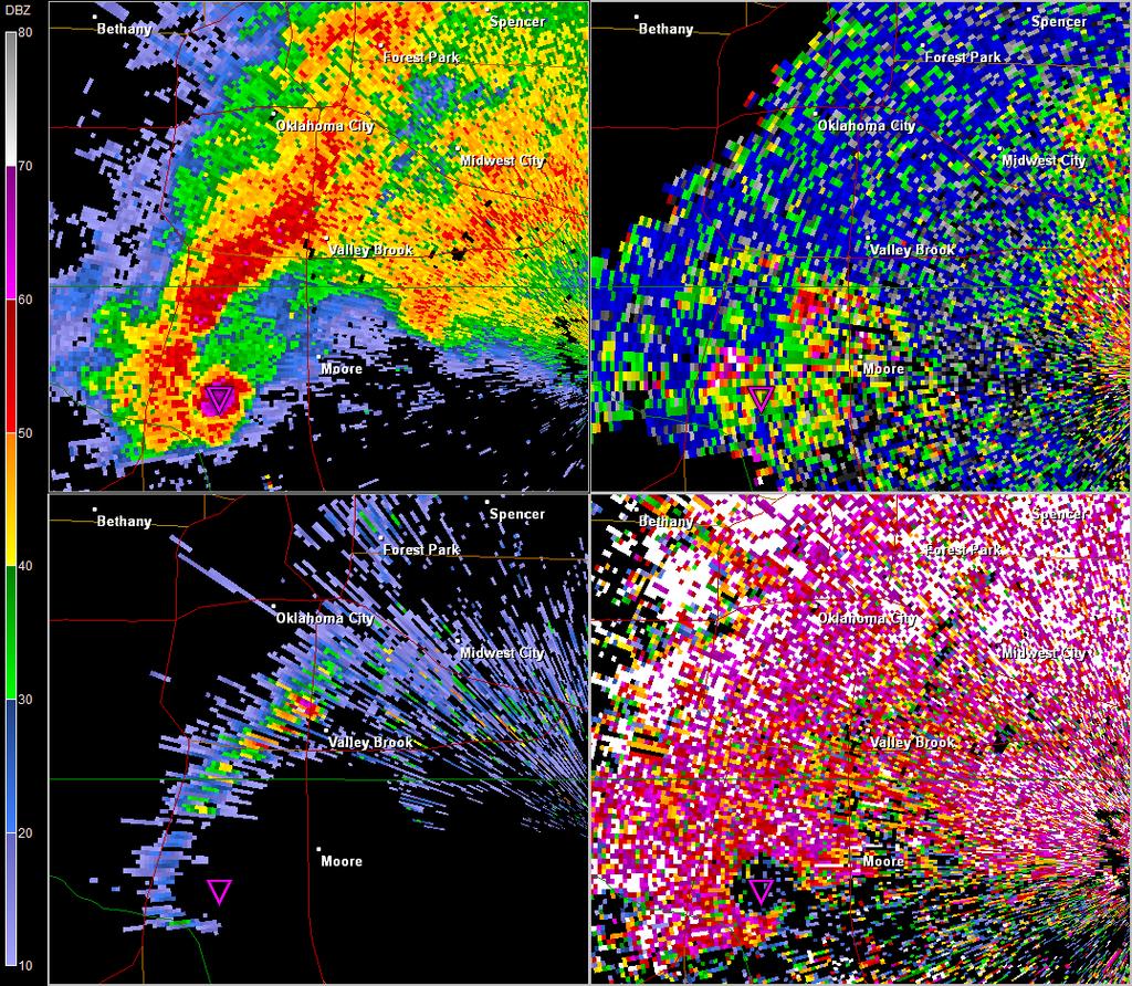
4 The convection during the afternoon and early evening hours of 19 May 2013 at 2200 UTC showed a line of severe storms in Kansas and several large discrete storms in Oklahoma (Fig. 9 upper). Based on Figure 8 there were other locations of severe weather (not shown) into the western Great Lakes. A similar pattern of the convection was evident 24 hours later as with a broken line of thunderstorms and discrete storms in Oklahoma. Though not shown, the convection moved well to east on the 21 st as implied in the severe reports from the Storm Prediction Center. The supercell which produced the deadly EF5 tornado in New Castle and Moore, OK had a very distinct signature in the hook echo near showing a nearly circular field in the hook itself at 2016 UTC 20 May This storm will likely be well studied over the next 1-2 years. 5. Summary A relatively slow moving Trough over the western United States and ridge over the eastern United States setup a relatively persistent pattern from May This pattern produced a period of enhanced severe weather over the United States from May 2013 (Table 1). Relative to the month of April 2013 this was an extremely active 4 day period which in fact produced more severe weather reports than were reported during the entire month of April The key features associated with the active severe weather of May 2013 included a slow moving Trough over the western United States and a ridge over the eastern United States. The resulting enhanced southerly flow, the evolution of a strong LLJ, between these two systems allowed warm moist air from the Gulf of Mexico to move into the central United States from Texas to the Great Lakes. This led to increased values of CAPE in close proximity to strong shear. The result was a multi-day period of enhanced severe weather with three successive days of 300 or more reports of severe weather from May 2013 (Table 1). These data show that despite previous conditions, a rapid change in the pattern can rapidly produce significantly different weather. The strong LLJ and instability, combined with a dry-line and an EML in the southern Plains to produce several days of destructive tornadoes. The dry air over the southwestern United States (Fig. 2) showed up in the CFS mean PW field, over western Oklahoma and Texas just west of the deep moist southerly flow to the east. The increasing westerly winds as the trough moved eastward likely pushed this warm dry air over the moist PBL setting up several days with an EML over eastern Oklahoma and the loaded gun soundings which were present during both of the tornadic events in Oklahoma (Figs. 3 & 6). 6. Acknowledgements Dana Tobin for image production in GR2 analyst of the Norman, OK tornado. 7. References
5 Banacos, Peter C., Michael L. Ekster, 2010: The Association of the Elevated Mixed Layer with Significant Severe Weather Events in the Northeastern United States. Wea. Forecasting, 25, LINK Carlson, T. N., and F. H. Ludlam, 1968: Conditions for the occurrence of severe local storms. Tellus, 20, Dry-line original reference Carlson, T. N., S. G. Benjamin, G. S. Forbes, and Y. F. Li, 1983: Elevated mixed layers in the regional severe storm environment: Conceptual model and case studies. Mon. Wea. Rev., 111, Doty, B.E. and J.L. Kinter III, 1995: Geophysical Data Analysis and Visualization using GrADS. Visualization Techniques in Space and Atmospheric Sciences, eds. E.P. Szuszczewicz and J.H. Bredekamp, NASA, Washington, D.C., Fawbush, E. J., and R. C. Miller, 1954: The types of air masses in which North American tornadoes form. Bull. Amer. Meteor. Soc.35, Gallus, W.A., N.A. Snook, and E.V. Johnson, 2008: Spring and Summer Severe Weather Reports over the Midwest as a Function of Convective Mode: A Preliminary Study. Wea. Forecasting, 23, Kalnay, E., and Coauthors, 1996: The NCEP/NCAR 40- Year Reanalysis Project. Bull. Amer. Meteor. Soc., 77, Saha, Suranjana, et. al., 2010: The NCEP Climate Forecast System Reanalysis. Bull. Amer. Meteor. Soc., In Press (DOI: /2010BAMS3001.1). Weaver, S. C., and S. Nigam, 2008: Variability of the Great Plains low level jet: Large scale circulation context and hydroclimate impacts. J. Climate,21,
6 Date(DTG) All severe Tornadoes General region of most reports 5/1/ /2/ /3/ /4/ /5/ /6/ /7/ Kansas 5/8/ Plains 5/9/ /10/ /11/ /12/ /13/ /14/ /15/ /16/ Texas 5/17/ Dakotas 5/18/ Southern Plains Southern Plains to western 5/19/ Lakes Southern Plains to Great Lakes 5/20/ /21/ Texas to Ohio Valley 5/22/ Eastern States 5/23/ West Texas Table 1. list of severe weather reports by date and the number of tornadoes reported in the total severe weather reports. Data from Storm Prediction Center as of 28 May Return to text.
 0000 UTC")
7 Figure 1. CFS analysis of 500 hpa heights and 500 hpa height anomalies over the United States in 24 hour increments from a) 0000 UTC 17 May 2013 through f) 0000 UTC 22 May The black dot is the approximate location of Moore, OK. Return to text.
 250 hpa u-wind and u-wind anomalies, b) 500 hpa heights and height anomalies, c) 850 hpa temperatures and temperature anomalies.")
8 Figure 2. CFS composite mean pattern and anomalies computed from 6-hourly data from 0000 UTC 18 through 0000 UTC 22 May Data shown include a) 250 hpa u-wind and u-wind anomalies, b) 500 hpa heights and height anomalies, c) 850 hpa temperatures and temperature anomalies. And d) precipitable water and precipitable water anomalies. Return to text.
9 Warm moist PBL Capping inversion Figure 3. Norman, Oklahoma sounding at 1200 UTC 20 May Courtesy of the University of Wyoming sounding archive site. The moist boundary layer, capping inversion and EML (red arrow above the inversion) are labeled. Return to text.

10 Figure 4. As in Figure 1 except for precipitable water in 24 hour increments from a) 0000 UTC 17 through f) 0000 UTC 22 May Return to text.
11 Figure 5. As in Figure 4 except for 850 hpa winds and 850 hpa v-wind anomalies. Return to text.
12 Figure 6. As in Figure 3 except for valid 1200 UTC 18,19 and 20 May Return to text.

13 Figure 7. As in Figure 5 except for CFS based CAPE in joules per kilogram shaded as in color bar. Return to text.
 for")
14 Figure 8. Severe weather reports by type from the Storm Prediction Center (SPC) for 18,19, 20, and 21 May Return to text. NWS State College Case Examples

 20 May 2013.")
15 Figure 9. Composite reflectivity at 2200 UTC (upper) 19 May 2013 and (lower) 20 May Data from the NMQ Q2 site. Return to text.

16 Figure 10. Base reflectivity at 2016 UTC 20 May 2013 showing the hook echo and approximate tornado near Moore, OK. Return to text.
17
Southern Plains Heavy rain and Flooding
 Abstract: Southern Plains Heavy rain and Flooding By Richard H. Grumm National Weather Service State College, PA A severe weather event affected the southern Plains on 31 May 2013. The severe weather event
Impacts of the April 2013 Mean trough over central North America
 Impacts of the April 2013 Mean trough over central North America By Richard H. Grumm National Weather Service State College, PA Abstract: The mean 500 hpa flow over North America featured a trough over
Early May Cut-off low and Mid-Atlantic rains
 Abstract: Early May Cut-off low and Mid-Atlantic rains By Richard H. Grumm National Weather Service State College, PA A deep 500 hpa cutoff developed in the southern Plains on 3 May 2013. It produced a
Heavy Rainfall Event of June 2013
 Heavy Rainfall Event of 10-11 June 2013 By Richard H. Grumm National Weather Service State College, PA 1. Overview A 500 hpa short-wave moved over the eastern United States (Fig. 1) brought a surge of
2 July 2013 Flash Flood Event
 2 July 2013 Flash Flood Event By Richard H. Grumm and Charles Ross National Weather Service State College, PA 1. Overview A retrograding 500 hpa cyclone and anticyclone (Fig. 1) set up deep southerly flow
Mid-West Heavy rains 18 April 2013
 Abstract: Mid-West Heavy rains 18 April 2013 By Richard H. Grumm and Charles Ross National Weather Service State College, PA The relatively wet conditions during the first 16 days of April 2013 set the
National Weather Service-Pennsylvania State University Weather Events
 National Weather Service-Pennsylvania State University Weather Events Eastern United States Winter Storm and Severe Event of 28-29 February 2012 by Richard H. Grumm National Weather Service State College
Memorial Day Weekend 2013: Snow and Cold
 Abstract: Memorial Day Weekend 2013: Snow and Cold By Richard H. Grumm National Weather Service State College, PA A slow moving 500 hpa low and associated unseasonably cold air in the lower troposphere
Eastern United States Wild Weather April 2014-Draft
 1. Overview Eastern United States Wild Weather 27-30 April 2014-Draft Significant quantitative precipitation bust By Richard H. Grumm National Weather Service State College, PA and Joel Maruschak Over
Southern United States Heavy rain and flood event 6-8 April 2014
 Southern United States Heavy rain and flood event 6-8 April 2014 By Richard H. Grumm National Weather Service State College, PA 1. Overview Heavy rainfall (Fig. 1) affected the southern United States from
Pre-Christmas Warm-up December 2013-Draft
 Pre-Christmas Warm-up 21-23 December 2013-Draft By Richard H. Grumm National Weather Service State College, PA 1. Overview A large ridge over the west-central Atlantic (Fig.1) and trough moving into eastern
NWS-PSU Case Study Site 2010 Severe Weather Case
 NWS-PSU Case Study Site 2010 Severe Weather Case New Years Eve Severe Weather Event of 31 December 2010 by Richard H. Grumm National Weather Service State College PA 16083 Abstract: A surge of warm humid
Tropical Storm Hermine: Heavy rainfall in western Gulf By Richard H. Grumm National Weather Service Office State College, PA 16803
 Tropical Storm Hermine: Heavy rainfall in western Gulf By Richard H. Grumm National Weather Service Office State College, PA 16803 1. INTRODUCTION Tropical storm Hermine, the eighth named tropical system
Deep Cyclone and rapid moving severe weather event of 5-6 June 2010 By Richard H. Grumm National Weather Service Office State College, PA 16803
 Deep Cyclone and rapid moving severe weather event of 5-6 June 2010 By Richard H. Grumm National Weather Service Office State College, PA 16803 1. INTRODUCTION A rapidly deepening surface cyclone raced
Flooding and Severe weather of 27 June 2013
 Flooding and Severe weather of 27 June 2013 By Richard H. Grumm National Weather Service State College, PA 1. Overview Flooding and severe weather affected Pennsylvania on 27 June 2013 (Fig 1). The severe
Devastating Tornadoes of 22 May 2011-Draft by Richard H. Grumm National Weather Service State College, PA
 Abstract: Devastating Tornadoes of 22 May 2011-Draft by Richard H. Grumm National Weather Service State College, PA A series of tornadoes struck the central United States on Sunday 22 May 2011. Tornadoes
National Weather Service-Pennsylvania State University Weather Events
 National Weather Service-Pennsylvania State University Weather Events The record eastern United States Severe Weather event of 3-4 April 2011-Draft by Richard H. Grumm National Weather Service State College
Heat wave ending severe events of July 2010 By Richard H. Grumm National Weather Service Office State College, PA 16803
 Heat wave ending severe events of 23-25 July 2010 By Richard H. Grumm National Weather Service Office State College, PA 16803 1. INTRODUCTION A strong subtropical ridge (Fig. 1a) dominated the eastern
Mid-Atlantic Ice Storm 4 March 2015
 1. Overview Mid-Atlantic Ice Storm 4 March 2015 By Richard H. Grumm National Weather Service State College, PA A large 500 hpa ridge over the southern United States (Fig. 1a-e)) built into the Mid-Atlantic
Severe Weather with a strong cold front: 2-3 April 2006 By Richard H. Grumm National Weather Service Office State College, PA 16803
 Severe Weather with a strong cold front: 2-3 April 2006 By Richard H. Grumm National Weather Service Office State College, PA 16803 1. INTRODUCTION A strong cold front brought severe weather to much of
National Weather Service-Pennsylvania State University Weather Events
 National Weather Service-Pennsylvania State University Weather Events March Madness: The 2 March 2012 super outbreak-draft by Richard H. Grumm National Weather Service State College PA 16803 and Kyle Imhoff
National Weather Service-Pennsylvania State University Weather Events
 National Weather Service-Pennsylvania State University Weather Events Historic Ohio Valley January Severe weather and Tornado Event by Richard H. Grumm National Weather Service State College PA 16803 and
Heavy rains and precipitable water anomalies August 2010 By Richard H. Grumm And Jason Krekeler National Weather Service State College, PA 16803
 Heavy rains and precipitable water anomalies 17-19 August 2010 By Richard H. Grumm And Jason Krekeler National Weather Service State College, PA 16803 1. INTRODUCTION Heavy rain fell over the Gulf States,
Snow, freezing rain, and shallow arctic Air 8-10 February 2015: NCEP HRRR success story
 Snow, freezing rain, and shallow arctic Air 8-10 February 2015: NCEP HRRR success story By Richard H. Grumm National Weather Service State College, PA 1. Overview A short-wave (Fig. 1) moved over the strong
New Zealand Heavy Rainfall and Floods
 New Zealand Heavy Rainfall and Floods 1. Introduction Three days of heavy rainfall associated with a deep upper-level low (Fig. 1) brought flooding to portions of New Zealand (Fig. 2). The flooding was
Convective Heavy rainfall event of 23 July 2013
 Convective Heavy rainfall event of 23 July 2013 By Richard H. Grumm and Charles Ross National Weather Service State College, PA Abstract: A record rain event affected southern Lebanon County on 23 July
HRRR and the Mid-Mississippi Valley Severe and Heavy rainfall event of October 2014
 HRRR and the Mid-Mississippi Valley Severe and Heavy rainfall event of 13-14 October 2014 By Richard H. Grumm National Weather Service State College, PA contributions by Charles Ross 1. Overview A deep
Severe Weather Event of 13 July 2014
 Severe Weather Event of 13 July 2014 By Richard H. Grumm and Elyse M. Colbert National Weather Service State College, PA 1. Overview Severe weather affected the eastern United States (Fig. 1) from northwestern
Mid Atlantic Severe Event of 1 May 2017 Central Pennsylvania QLCS event By Richard H. Grumm National Weather Service, State College, PA 16803
 1. Overview Mid Atlantic Severe Event of 1 May 2017 Central Pennsylvania QLCS event By Richard H. Grumm National Weather Service, State College, PA 16803 A strong upper-level wave (Fig.1) moving into a
National Weather Service-Pennsylvania State University Weather Events
 National Weather Service-Pennsylvania State University Weather Events The southern Express: High Impact Spring Storm of 14-17 April 2011 by Richard H. Grumm National Weather Service State College PA 16803
Winter Storm of 15 December 2005 By Richard H. Grumm National Weather Service Office State College, PA 16803
 Winter Storm of 15 December 2005 By Richard H. Grumm National Weather Service Office State College, PA 16803 1. INTRODUCTION A complex winter storm brought snow, sleet, and freezing rain to central Pennsylvania.
National Weather Service-Pennsylvania State University Weather Events
 National Weather Service-Pennsylvania State University Weather Events Heavy rainfall of 23 November 2011 by Richard H. Grumm National Weather Service State College PA 16803 Abstract:. A fast moving mid-tropospheric
Pennsylvania Severe Weather of September 2016
 Pennsylvania Severe Weather of September 2016 By Richard H. Grumm National Weather Service State College, PA 1. Overview September 2016 was a relatively quiet month for severe weather across most of the
Indiana County Flash Flood of 22 June 2017
 Indiana County Flash Flood of 22 June 2017 By Richard H. Grumm National Weather Service State College, PA 1. Overview Slow moving thunderstorms brought 3 to 4 inches of rainfall to Indiana County, PA during
Mid-Atlantic Severe Weather Event of 23 June 2015
 Mid-Atlantic Severe Weather Event of 23 June 2015 By Richard H. Grumm National Weather Service State College, PA 1. Overview A widespread severe weather event occurred in the eastern United States on 23
Thanksgiving Eve snow of November 2014
 1. Overview Thanksgiving Eve snow of 26-27 November 2014 By Richard H. Grumm National Weather Service State College, PA An early season east coast winter storm (ECWS: DeGaetano et al. 2002) brought snow
A summary of the heat episodes of June 2017
 A summary of the heat episodes of June 2017 By Richard H. Grumm and Elissa A. Smith National Weather Service State College, PA 1. Overview Over 1800 record high temperatures were set or tied during the
Southern Heavy rain and floods of 8-10 March 2016 by Richard H. Grumm National Weather Service State College, PA 16803
 Southern Heavy rain and floods of 8-10 March 2016 by Richard H. Grumm National Weather Service State College, PA 16803 1. Introduction Heavy rains (Fig. 1) produced record flooding in northeastern Texas
1. INTRODUCTION * Figure 1. National Weather Service Storm Prediction Center (SPC) storm reports for December 1, 2006.
 storm reports for December 1, 2006.") P1.14 FORECAST ISSUES RELATED TO THE UNPRECEDENTED SEVERE AND HIGH WIND EVENT OF DECEMBER 2006 by Greg A. DeVoir* and Richard H. Grumm National Weather Service Office State College, PA 16803 1. INTRODUCTION
P1.14 FORECAST ISSUES RELATED TO THE UNPRECEDENTED SEVERE AND HIGH WIND EVENT OF DECEMBER 2006 by Greg A. DeVoir* and Richard H. Grumm National Weather Service Office State College, PA 16803 1. INTRODUCTION
The Big Chill of November 2013
 The Big Chill of November 2013 Value of anomalies for situational awareness By Richard H. Grumm National Weather Service State College, PA Trevor Alcott National Weather Service, Salt Lake City UT 1. Overview
Low-end derecho of 19 August 2017
 Low-end derecho of 19 August 2017 By Richard H. Grumm and Charles Ross National Weather Service State College, PA 1. Overview A cluster of thunderstorms developed in eastern Ohio around 1800 UTC on 19
Eastern United States Winter Storm of 1-2 February 2015-DRAFT Northeast Ground Hog Storm
 Eastern United States Winter Storm of 1-2 February 2015-DRAFT Northeast Ground Hog Storm By Richard H. Grumm National Weather Service State College, PA 1. Overview A major Winter Storm brought precipitation
P3.17 THE DEVELOPMENT OF MULTIPLE LOW-LEVEL MESOCYCLONES WITHIN A SUPERCELL. Joshua M. Boustead *1 NOAA/NWS Weather Forecast Office, Topeka, KS
 P3.17 THE DEVELOPMENT OF MULTIPLE LOW-LEVEL MESOCYCLONES WITHIN A SUPERCELL Joshua M. Boustead *1 NOAA/NWS Weather Forecast Office, Topeka, KS Philip N. Schumacher NOAA/NWS Weather Forecaster Office, Sioux
Mid-Atlantic Severe Event of 1 June 2012
 Mid-Atlantic Severe Event of 1 June 2012 1. Introduction An unseasonably deep midtropospheric ridge (Fig. 1) brought a strong cold front into the Mid-Atlantic region on 1 June 2012. A surge of warm moist
National Weather Service-Pennsylvania State University Weather Events
 National Weather Service-Pennsylvania State University Weather Events Abstract: West Coast Heavy Precipitation Event of January 2012 by Richard H. Grumm National Weather Service State College PA 16803
1. INTRODUCTION. For brevity times are referred to in the format of 20/1800 for 20 August UTC. 3. RESULTS
 Heavy rains and precipitable water anomalies 20-23 August 2010-Draft By Jason Krekeler And Richard Grumm National Weather Service State College, PA 16803 1. INTRODUCTION Heavy rain fell across the central
Cold frontal Rainband and Mid-Atlantic Severe Weather Event 28 September 2006 by Richard H. Grumm And Ron Holmes
 Cold frontal Rainband and Mid-Atlantic Severe Weather Event 28 September 2006 by Richard H. Grumm And Ron Holmes 1. INTRODUCTION A strong cold front moved across central Pennsylvania and the Mid-Atlantic
Southern United States Winter Storm of 28 January 2014-v1. High Impact Snow on Edge of Forecast Precipitation Shield
 Southern United States Winter Storm of 28 January 2014-v1 High Impact Snow on Edge of Forecast Precipitation Shield by Richard H. Grumm National Weather Service State College, PA 16803 and 1. Introduction
Early Summer Heat Waves of 2013
 Early Summer Heat Waves of 2013 Abstract: By Richard H. Grumm National Weather Service State College, PA And Trevor Alcott National Weather Service, Salt Lake City Utah From late June into mid-july large
Winter Storm of February 2008 By Richard H. Grumm National Weather Service Office State College PA 16803
 1. INTRODUCTION Winter Storm of 11-13 February 2008 By Richard H. Grumm National Weather Service Office State College PA 16803 A potent winter storm brought snow, sleet, freezing rain, and rain to the
Heavy Rainfall and Flooding of 23 July 2009 By Richard H. Grumm And Ron Holmes National Weather Service Office State College, PA 16803
 Heavy Rainfall and Flooding of 23 July 2009 By Richard H. Grumm And Ron Holmes National Weather Service Office State College, PA 16803 1. INTRODUCTION Heavy rains fall over Pennsylvania and eastern New
Northeastern United States Snowstorm of 9 February 2017
 Northeastern United States Snowstorm of 9 February 2017 By Richard H. Grumm and Charles Ross National Weather Service State College, PA 1. Overview A strong shortwave produced a stripe of precipitation
1. INTRODUCTION. The super storm of March 1993 produced severe weather and tornadoes as it s trailing cold front pushed through Florida (Kocin eta 1l
 1. INTRODUCTION Super Tuesday and awful Wednesday: the 5-6 February 2008 Severe Weather Outbreak By Richard H. Grumm National Weather Service State College, PA And Seth Binau National Weather Service,
National Weather Service-Pennsylvania State University Weather Events
 National Weather Service-Pennsylvania State University Weather Events Abstract: Tropical Storm Debbie, standardized anomalies and heavy rainfall by Richard H. Grumm National Weather Service State College
Case Study 3: Dryline in TX and OK 3 May 1999
 Case Study 3: Dryline in TX and OK 3 May 1999 Brandy Lumpkins Department of Atmospheric and Oceanic Sciences University of Wisconsin Madison 8 May 2006 ABSTRACT A massive tornadic outbreak swept across
Orographically enhanced heavy rainfall of 23 May 2010 By Richard H. Grumm National Weather Service Office State College, PA 16803
 Orographically enhanced heavy rainfall of 23 May 2010 By Richard H. Grumm National Weather Service Office State College, PA 16803 1. INTRODUCTION During the overnight hours and into the early morning of
ANSWER KEY. Part I: Synoptic Scale Composite Map. Lab 12 Answer Key. Explorations in Meteorology 54
 ANSWER KEY Part I: Synoptic Scale Composite Map 1. Using Figure 2, locate and highlight, with a black dashed line, the 500-mb trough axis. Also, locate and highlight, with a black zigzag line, the 500-mb
The Severe Weather Event of 7 August 2013 By Richard H. Grumm and Bruce Budd National Weather Service State College, PA 1. INTRODUCTION and Overview
 The Severe Weather Event of 7 August 2013 By Richard H. Grumm and Bruce Budd National Weather Service State College, PA 1. INTRODUCTION and Overview A fast moving short-wave (Fig. 1) with -1σ 500 hpa height
The North American Heat Wave of July 2011-Draft
 The North American Heat Wave of July 2011-Draft By Richard H. Grumm And Jason Krekeler 328 Innovation Blvd Suite 330 National Weather Service Office State College, PA 16803 The meteorological conditions
The Long-lived eastern US tornadic supercell of 20 July 2017
 1. Overview The Long-lived eastern US tornadic supercell of 20 July 2017 By Richard H. Grumm and Elissa A Smith National Weather Service State College, PA A long lived supercell developed near the eastern
Minor Winter Flooding Event in northwestern Pennsylvania January 2017
 1. Overview Minor Winter Flooding Event in northwestern Pennsylvania 12-13 January 2017 By Richard H. Grumm National Weather Service State College, PA A combination of snow melt, frozen ground, and areas
Mesoscale Convective System and heat episode July 2005 by Richard H. Grumm and Mathew Steinbugl
 Mesoscale Convective System and heat episode 25-27 July 2005 by Richard H. Grumm and Mathew Steinbugl 1. INTRODUCTION A strong upper-level ridge brought unseasonably high temperatures to the Midwest and
Eastern Derecho June 2013-Draft
 Abstract: Eastern Derecho 12-13 June 2013-Draft Richard H. Grumm National Weather Service Office State College, PA 16803 A strong mid-tropospheric short-wave coming over a sharp 500 hpa ridge produced
Isolated severe weather and cold air damming 9 November 2005 By Richard H. Grumm National Weather Service Office State College, PA 16801
 Isolated severe weather and cold air damming 9 November 2005 By Richard H. Grumm National Weather Service Office State College, PA 16801 1. INTRODUCTION Two lines of convection moved over the State of
The southern express: Winter storm of January 2010 By Richard H. Grumm National Weather Service
 The southern express: Winter storm of 28-30 January 2010 By Richard H. Grumm National Weather Service 1. INTRODUCTION A storm system of Pacific origin tracked across the southern United States from 27-31
Arkansas Flash Floods and heavy rainfall-draft By Richard H. Grumm National Weather Service State College PA 16803
 Arkansas Flash Floods and heavy rainfall-draft By Richard H. Grumm National Weather Service State College PA 16803 1. INTRODUCTION Training convection associated with deep moisture and a strongly southerly
End of heat-event severe event of 7 July 2012
 End of heat-event severe event of 7 July 2012 Richard H. Grumm And Elyse Colbert National Weather Service Office State College, PA 16803 1. Overview A widespread severe weather event affected Pennsylvania
Mid Atlantic Heavy rainfall event 1. Overview 2. Methods and Data 3. Pattern
 1. Overview Mid Atlantic Heavy rainfall event With an inertial gravity wave? By Richard H. Grumm National Weather Service, State College, PA 16803 Contributions from the Albany MAP An unseasonably strong
Analysis of Severe Storm Initiation Along Drylines in the Southern Plains
 Analysis of Severe Storm Initiation Along Drylines in the Southern Plains NICOLE L. BARBEE Meteorology Program, Iowa State University, Ames Mentor: Dr. William Gallus 1 1 Department of Geological and Atmospheric
Alaskan heat episode of June 2013-Draft
 Alaskan heat episode of 16-19 June 2013-Draft Abstract: By Trevor Alcott National Weather Service Western Region, Salt Lake City UT And Richard H. Grumm National Weather Service State College, PA A strong
5A.3 THE USE OF ENSEMBLE AND ANOMALY DATA TO ANTICIPATE EXTREME FLOOD EVENTS IN THE NORTHEASTERN U.S.
 5A.3 THE USE OF ENSEMBLE AND ANOMALY DATA TO ANTICIPATE EXTREME FLOOD EVENTS IN THE NORTHEASTERN U.S. Neil A. Stuart(1), Richard H. Grumm(2), John Cannon(3), and Walt Drag(4) (1)NOAA/National Weather Service,
Boundary-layer Decoupling Affects on Tornadoes
 Boundary-layer Decoupling Affects on Tornadoes Chris Karstens ABSTRACT The North American low-level jet is known to have substantial impacts on the climatology of central and eastern regions of the United
Anticipating record events using patterns and pattern forecast: Mid-Mississippi Valley floods of April 2011
 Anticipating record events using patterns and pattern forecast: Mid-Mississippi Valley floods of April 2011 Richard H. Grumm National Weather Service State College, PA Abstract: A persistent pattern produced
1995 and 1980 (exact dates would be useful). 1. INTRODUCTION
. 1. INTRODUCTION") Alaskan Autumn Storm of 22-24 November 2010 By Richard Grumm National Weather Service State College, PA 16803 and Rick Thoman and James A. Nelson National Weather Service Alaska Region 1. INTRODUCTION
Alaskan Autumn Storm of 22-24 November 2010 By Richard Grumm National Weather Service State College, PA 16803 and Rick Thoman and James A. Nelson National Weather Service Alaska Region 1. INTRODUCTION
Warm Episode over Indian Sub-continent March 2010 By Richard Grumm National Weather Service State College Contributions by Lance Bosart SUNY Albany
 Warm Episode over Indian Sub-continent March 2010 By Richard Grumm National Weather Service State College Contributions by Lance Bosart SUNY Albany 1. INTRODUCTION A massive subtropical ridge formed over
The Devastating Western European Winter Storm February 2010 By Richard H. Grumm National Weather Service
 The Devastating Western European Winter Storm 27-28 February 2010 By Richard H. Grumm National Weather Service 1. INTRODUCTION A strong late winter storm, called Xynthia 1, raced across Western Europe
The enduring Louisiana rain and flooding of August 2016 by Richard H. Grumm National Weather Service State College, PA 16803
 1. Introduction The enduring Louisiana rain and flooding of August 2016 by Richard H. Grumm National Weather Service State College, PA 16803 Historic flooding impacted Louisiana on 12-15 August 2016 (TWC
1. INTRODUCTION. In addition to the severe weather, the
 Anomalous Low and its weather impacts 10-12 May 2008 By Richard Grumm National Weather Service Office State College, PA And Al Cope National Weather Service Office Mount Holly, NJ 1. INTRODUCTION An unusually
Hurricane Harvey the Name says it all. by Richard H. Grumm and Charles Ross National Weather Service office State College, PA
 Hurricane Harvey the Name says it all by Richard H. Grumm and Charles Ross National Weather Service office State College, PA 16803. 1. Overview Hurricane Harvey crossed the Texas coast (Fig. 1) as a category
National Weather Service-Pennsylvania State University Weather Events
 National Weather Service-Pennsylvania State University Weather Events Heavy Rain 7-8 December 2011 by Richard H. Grumm National Weather Service State College PA 16803 Abstract:. A mid-level short-wave
Krymsk Flood of 6-7 July 2012-Draft
 1. Overview Krymsk Flood of 6-7 July 2012-Draft A flood ripped through the Russian town of Krymsk overnight on 6-7 July 2012. The flood killed 172 people and 35000 people were injured or suffered losses
Warm Episode of December 2015:
 Warm Episode of 11-16 December 2015: Record Warmth over Mid-Atlantic Region By Richard H. Grumm National Weather Service State College, PA 1. Overview A strong 500 hpa ridge over the eastern United States
4/18/2010. National Weather Service. Severe Weather Forecasting: A Western North Carolina Case Study
 National Weather Service Severe Weather Forecasting: A Western North Carolina Case Study Laurence G. Lee Science and Operations Officer National Weather Service Greer, SC Plus 13 River Forecast Centers
Mid-Atlantic Derecho event of 29 June 2012
 Mid-Atlantic Derecho event of 29 June 2012 Richard H. Grumm Charles H. Ross And Elyse Colbert National Weather Service Office State College, PA 16803 1. Overview An area of convection developed over eastern
The Deep South snowfall of February 2010 By Richard H. Grumm National Weather Service Office, State College, PA 16803
 The Deep South snowfall of 11-13 February 2010 By Richard H. Grumm National Weather Service Office, State College, PA 16803 1. INTRODUCTION A surface cyclone tracked across Mexico and the Gulf of Mexico
Determining Environmental Parameters Most Important for Significant Cool Season Tornadoes across the Gulf Coastal States
 Determining Environmental Parameters Most Important for Significant Cool Season Tornadoes across the Gulf Coastal States Kar retta Venable Jackson State University, Jackson, MS Mentors David Imy NOAA/NWS/NCEP/Storm
The Historic Storm of October 2010 By Richard H. Grumm National Weather Service
 The Historic Storm of 24-26 October 2010 By Richard H. Grumm National Weather Service 1. INTRODUCTION An historic storm impacted much of the United States from 24-26 October 2010. Though the cyclone was
THE SYNOPTIC ENVIRONMENT OF THE 11 APRIL 2001 CENTRAL PLAINS TORNADO OUTBREAK VIEWED IN THREE DIMENSIONS
 P1.1 THE SYNOPTIC ENVIRONMENT OF THE 11 APRIL 2001 CENTRAL PLAINS TORNADO OUTBREAK VIEWED IN THREE DIMENSIONS Daniel D. Nietfeld * NOAA/NWS/WFO Omaha/Valley, NE 1. INTRODUCTION A powerful low pressure
Hurricane Alex: Heavy rainfall and anomalous precipitable water By Richard H. Grumm National Weather Service Office State College, PA 16803
 Hurricane Alex: Heavy rainfall and anomalous precipitable water By Richard H. Grumm National Weather Service Office State College, PA 16803 1. INTRODUCTION Hurricane Alex ambled across the Gulf of Mexico
The Jarrell Tornado of May 27, 1997
 The Jarrell Tornado of May 27, 1997 ANDREW MANKOWSKI University of Wisconsin Madison Atmospheric and Oceanic Sciences ABSTRACT A tornado outbreak occurred over Central Texas on May 27, 1997. This outbreak
Anthony A. Rockwood Robert A. Maddox
 Anthony A. Rockwood Robert A. Maddox An unusually intense MCS produced large hail and wind damage in northeast Kansas and northern Missouri during the predawn hours of June 7 th, 1982. Takes a look at
National Weather Service-Pennsylvania State University Weather Events
 National Weather Service-Pennsylvania State University Weather Events New Zealand heavy rain and flood event-draft by Richard H. Grumm National Weather Service State College PA 16803 Abstract:. A record
Synoptic Environments Associated with Significant Tornadoes in the Contiguous United States
 Synoptic Environments Associated with Significant Tornadoes in the Contiguous United States JAYSON A. PRENTICE Department of Geological and Atmospheric Sciences, Iowa State University, Ames, IA Mentor:
MJO Influence in Continental United States Temperatures
 MJO Influence in Continental United States Temperatures An honors thesis presented to the Department of Atmospheric Science, University at Albany, State University Of New York in partial fulfillment of
COMPOSITE MEANS AND ANOMALIES OF METEOROLOGICAL PARAMETERS FOR SUMMERTIME FLASH FLOODING IN THE NATIONAL WEATHER SERVICE EASTERN REGION
 COMPOSITE MEANS AND ANOLIES OF METEOROLOGICAL PARAMETERS FOR SUMMERTIME FLASH FLOODING IN THE NATIONAL WEATHER SERVICE EASTERN REGION Alan M. Cope and Lee Robertson NOAA/National Weather Service Mount
A COMPREHENSIVE 5-YEAR SEVERE STORM ENVIRONMENT CLIMATOLOGY FOR THE CONTINENTAL UNITED STATES 3. RESULTS
 16A.4 A COMPREHENSIVE 5-YEAR SEVERE STORM ENVIRONMENT CLIMATOLOGY FOR THE CONTINENTAL UNITED STATES Russell S. Schneider 1 and Andrew R. Dean 1,2 1 DOC/NOAA/NWS/NCEP Storm Prediction Center 2 OU-NOAA Cooperative
Summary of November Central U.S. Winter Storm By Christopher Hedge
 Summary of November 12-13 2010 Central U.S. Winter Storm By Christopher Hedge Event Overview The first significant snowfall of the 2010-2011 season affected portions of the plains and upper Mississippi
The abrupt end of the Persistent Subtropical Ridge of the autumn of 2016
 The abrupt end of the Persistent Subtropical Ridge of the autumn of 2016 1. Introduction by Richard H. Grumm National Weather Service State College, PA 16803 Contributions by Elyse Hagner National Weather
Multiscale Analyses of Inland Tropical Cyclone Midlatitude Jet Interactions: Camille (1969) and Danny (1997)
 and Danny (1997)") Multiscale Analyses of Inland Tropical Cyclone Midlatitude Jet Interactions: Camille (1969) and Danny (1997) Matthew Potter, Lance Bosart, and Daniel Keyser Department of Atmospheric and Environmental
Multiscale Analyses of Inland Tropical Cyclone Midlatitude Jet Interactions: Camille (1969) and Danny (1997) Matthew Potter, Lance Bosart, and Daniel Keyser Department of Atmospheric and Environmental
Recent Trends in Northern and Southern Hemispheric Cold and Warm Pockets
 Recent Trends in Northern and Southern Hemispheric Cold and Warm Pockets Abstract: Richard Grumm National Weather Service Office, State College, Pennsylvania and Anne Balogh The Pennsylvania State University