Challenging Aspects of Severe Tropical Cyclone George s s Track Forecasts
|
|
|
- Doris Cross
- 5 years ago
- Views:
Transcription
1 Challenging Aspects of Severe Tropical Cyclone George s s Track Forecasts Jim DAVIDSON Former Affilliation


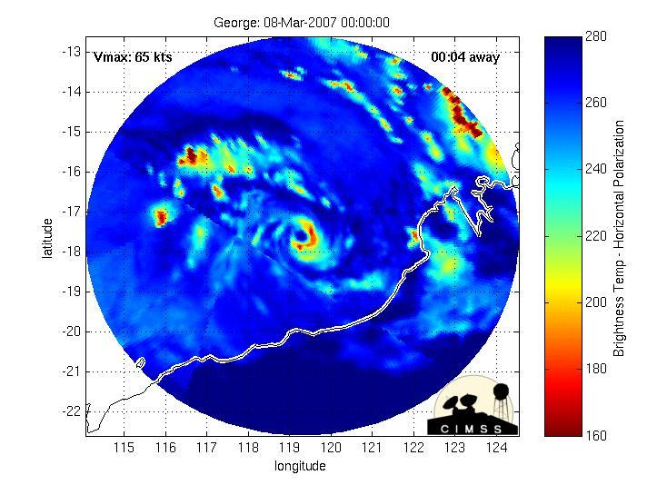
2 Severe Tropical Cyclone George bears down on the Western Australian Coast in early March 2007

3 Tropical Cyclone George March 2007
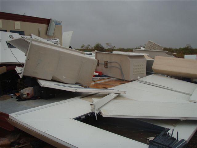
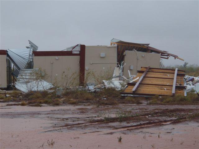
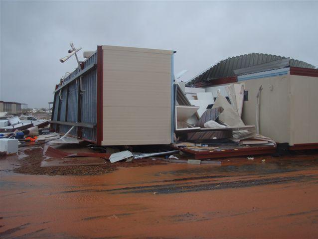
4 Setting the Scene STC George was both very intense and physically large 3 fatalities numerous injuries localised damage 10 minute mean wind = 194 km/h recorded just offshore Equivalent to wind gusts reaching 275 km/h Very destructive winds to about 115 km inland 5 metre storm tide but landfall near the bottom of the tide Substantial but not significant rainfalls occurred No major flooding due lack of previous rainfall and the steady movement of the cyclone Track forecasts were very challenging and the focus of this presentation

5 4 Panels of Multi Sensor Satellite Imagery close to Landfall
6

7 Radar Image with the elliptical eye of George straddling the coast

8 Very Destructive Wind swath of TC George extended well inland

9
10 Track Forecast Performance WA TC Forecast Accuracy : season Accuracy (km) Forecast Tim e (h) George Jacob Kara 01/02 05/06 Average
11 Selection of Forecast Tracks & Best Track at base time UTC Best Track in Black with Multi model Forecast Tracks in various colours

12 Selection of Forecast Tracks & Best Track at base time UTC Best Track in Black with Multi model Forecast Tracks in various colours
13 Selection of Forecast Tracks & Best Track at base time UTC Best Track in Black with Multi model Forecast Tracks in various colours
14 Selection of Forecast Tracks & Best Track at base time UTC Best Track in Black with Multi model Forecast Tracks in various colours

15 EC Model Track Forecast Ensemble at base time UTC

16 Warning Graphic with 24/48 hour Forecasts base time UTC

17 One exception to the generalisation The UKMO ensemble did indicate the possibility of a tight recurvature but this prediction was made earlier on 3 March. Amidst other guidance, including later runs of the UKMO, it did not influence the forecast to any degree except maybe to raise the probability of such a scenario from zero to still quite a very low number.
18 Warning Performance The possibility that George could recurve to the south was identified late morning on 7 March and a Cyclone Watch was issued for coastal and island communities The section of coast where George ultimately made landfall was first put under Cyclone Warning late on 7 March, approximately 24 hours prior to landfall Warnings consistently indicated that George was expected to impact the coast as a Severe TC Moreover the warnings specifically stated that the system was expected to produce very destructive winds for more than 100 km inland
19 TCWC Methodology Meteorologists in the TCWC construct track forecasts based on a consensus approach, combining available dynamical and statistical forecast aids The forecasts issued by the TCWC drew directly upon guidance from 9 independent models Meteorologists also informed their decision making by accessing output from models run in ensemble mode Despite being the most skilful track forecasting methodology available and practised in all major TCWCs it is still dependent on the skill of the component guidance
20 TCWC Methodology Remarkedly, the available guidance had a small spread (very little variation in direction and speed of the tracks) None of the available guidance foreshadowed the abrupt southerly shift in motion This was considered a surprising outcome even in 2007 It was extremely rare for all available guidance to fail Small spread lends to higher confidence in the track forecast Hence this is the worst situation a TCWC meteorologist can face namely a small spread leading to high confidence, but ultimately large error
21 Error Vs Spread 1. Small Spread/Large Error: Nightmare 2. Large Spread/Large Error: Largest opportunity for improvement 3. Small Spread/Small Error: Ideal Case 4. Large Spread/Small Error: Opposing errors cancel each other out


22 Small Model Spread Large Error George the hard one!
23 A Puzzling Question Assuming a model has a fair and realistic representation of the TC and the environment, why/how does it steer the system in a direction inconsistent with the steering flows it depicts?
24 TC Steering 101 (largely courtesy of NRL Monterey) TC motion is the result of a complex interaction between a number of internal and external influences Large scale environmental steering is typically the most prominent external influence on a TC, accounting for as much as 70 to 90% of the motion and is computed by separating the TC wind fields from the large scale environmental wind fields (which is easier said than done) Separation of flow is dependent on the situation but can be anywhere from 1 7 degrees from the centre of the TC Deep layer mean steering is obviously best but a single layer computation can sometimes provide a crude estimate Internal influences (such as the Beta Effect) steer the TC poleward and westward in both hemispheres
25 Possible Significant Factors leading to the Sharp Recurvature TC Humba (undergoing ETT well upstream) TC Jacob (Fujiwhara Effect) Beta Effect Poorly represented monsoonal flow in the models (Assymetrical Convection not a consideration here)
26 Possible Significant Factors leading to the Sharp Recurvature TC Humba (undergoing ETT well upstream) TC Jacob (Fujiwhara Effect) Beta Effect Poorly represented monsoonal flow in the models
 and is")

27 TC Humba was undergoing ETT well upstream (near 90E) and is unlikely to have influenced George s track to any measurable degree
28 Possible Significant Factors leading to the Sharp Recurvature TC Humba (undergoing ETT well upstream) TC Jacob (Fujiwhara Effect) Beta Effect Poorly represented monsoonal flow in the models
29 TC Tech Bulletin issued 0112 UTC 07/03/2007 by the Perth TCWC:... No model has effectively captured TC Jacob in the analysis fields, and therefore all guidance is considered with some caution. Interaction between the two systems may imply a greater level of SW motion in the short term, but may also hinder any recurvature in the longer term....
30 I am almost 100% convinced that this was all down to the model's handling of Jacob. I am giving a talk at a symposium later this week on why tropical cyclone forecasts sometimes go wrong. I plan to make this one of my prime examples! It illustrates that modelling the environment around the tropical cyclone is just as important as modelling the cyclone itself to get a good forecast. Julian Heming Tropical Prediction Scientist UK Met Office


31 Jacob was relatively weak and moving further away from George during the critical forecast period J G Track of TC Jacob
32 TC George TC Jacob interaction george 100 7/3 09Z 4/3 00Z Jacob /3 00Z 100 7/3 09Z
33 TC George TC Jacob Interaction TC George was larger and more intense Expect greater effect on TC Jacob s track Break in interaction as cause of S ly motion? Systems don t breach direct interaction threshold From late on the 5 th interaction would have decreased as separation increased Systems continued to separate around time of TC George s abrupt change in direction towards the south Independent or causal? Weak argument given distance and relative strengths
34 Possible Significant Factors leading to the Sharp Recurvature TC Humba (undergoing ETT well upstream) TC Jacob (Fujiwhara Effect) Beta Effect Poorly represented monsoonal flow in the models
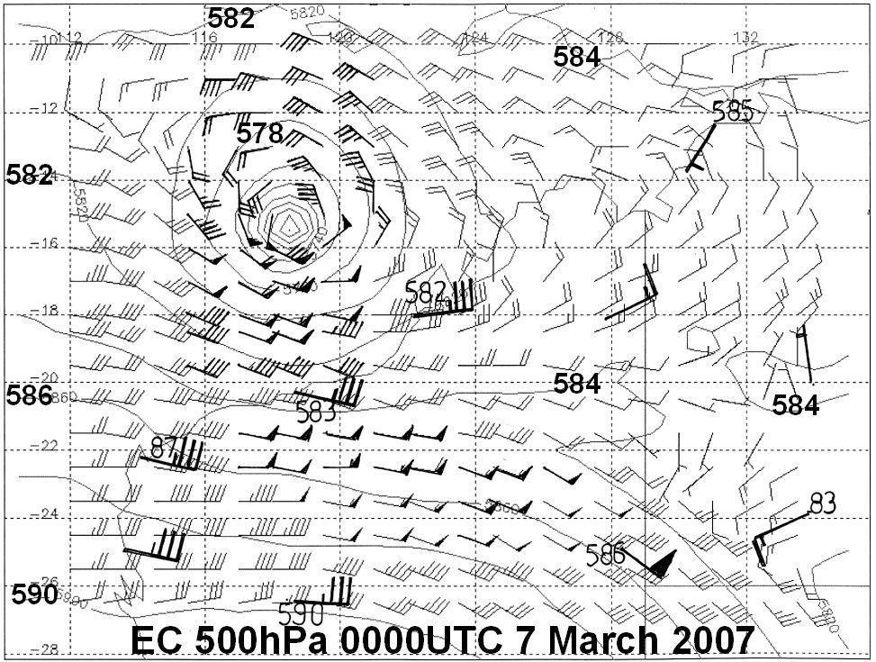
35 Beta Effect 101 (largely courtesy of NRL Monterey) Local change of the vertical component of relative vorticity maximum value at the equator and zero at the poles Causes TCs to move polewards and westward with a speed of several degrees per day (in the absence of the largescale steering flow) Function of the TC size but not necessarily the TC intensity When the TC size is large (as with George), the Beta Effect may have some impact on the motion and should therefore be considered when developing track forecast strategy
36 Beta Effect on George Physically large therefore expect greater beta effect Likely to have influenced the motion to some degree but difficult to argue that the beta effect contributed in a significant way to the abrupt change in direction Far more likely that the beta effect would have lead to a more gradual change in direction towards the southwest
37 Possible Significant Factors leading to the Sharp Recurvature TC Humba (undergoing ETT well upstream) TC Jacob (Fujiwhara Effect) Beta Effect Poorly represented monsoonal flow in the models
38
39
40
41


42 300/50 knots 090/50 knots 010/25 190/25 knots

43 4 Sector Vector Analysis at UTC EC 500 hpa North 300/50 East 330/30 South 100/60 West 130/20 SUM 025/35


44 UTC UTC TXLAPS 500 hpa Wind Analyses UTC UTC

45 TXLAPS 500 hpa Wind Analysis at UTC
46

47 TC Justin in 1997 was centred in the Coral Sea off Queensland. The system was located north of a strong 500 hpa ridge and all computer models forecast it to move under the influence of the middle level easterlies on to the Queensland coast. However the monsoon westerly flow to the north was very strong and deep such that the easterly flow was balanced by the monsoon flow and the system remained stationary.

48 TC LUA 2012 small spread & small error

49 Animation of Model & Actual IR Imagery (TC LUA) Animation of Synthetic and Actual IR Imagery (Sun and Rikus, 2004) ACCESS TC Operational Forecast of TC Lua, Base Time 12UTC, 15 March 2012 Courtesy Lawrie Rikus, ESM Program, CAWCR Sun, Z. and L.J. Rikus, 2004: Validating model clouds and their optical properties using Geostationary satellite imagery. Mon. Wea. Rev., 132,


50 Severe Tropical Cyclone YASI

51 Track of TC YASI with extent of hurricane, storm & gale force winds Bright RED = Hurricane force winds


52 TC YASI a really good example of Small Spread & Small Error for almost a week leading up to landfall

53 TC Yasi Forecast Tracks
 Forecast")
54 TC YASI (& TC ULUI) ) Forecast Performance


55 Model forecasts for SANDY were exceptional out to 7 days Deterministic EC Multi Model Ensemble Strike Probability Map
56 In conclusion The influence of strong and deep monsoonal westerlies on the steering flow of TCs is not always fully captured by numerical models (as highlighted with TC George) Consensus track forecasting has been largely a positive experience but still value from detailed synoptic analysis Increased availability of near real time wind field analyses from a suite of numerical models together with remote sensed wind data over the oceans should hopefully lead to careful synoptic analysis being a routine function in TCWCs (if of course forecaster numbers allow)

57 Thank you Questions?
Track Forecasting Are TCs unpredictable'?
 Track Forecasting Are TCs unpredictable'? 1/25 Conceptual frameworks The process NWP Consensus processes Ensembles 2/25 Does track depend upon the intensity? Changes in inner core processes have little
Activity Report for Australian TCWCs 2009/2012
 Activity Report for Australian TCWCs 2009/2012 7th RSMC/TCWC Co-ordination Meeting Citeko, November 2012 Mike Bergin Regional Director (Western Australia) Bureau of Meteorology Outline Significant Cyclones
(April 7, 2010, Wednesday) Tropical Storms & Hurricanes Part 2
 Tropical Storms & Hurricanes Part 2") Lecture #17 (April 7, 2010, Wednesday) Tropical Storms & Hurricanes Part 2 Hurricane Katrina August 2005 All tropical cyclone tracks (1945-2006). Hurricane Formation While moving westward, tropical disturbances
Lecture #17 (April 7, 2010, Wednesday) Tropical Storms & Hurricanes Part 2 Hurricane Katrina August 2005 All tropical cyclone tracks (1945-2006). Hurricane Formation While moving westward, tropical disturbances
Major Hurricane Matthew Briefing Situation Overview
 Major Hurricane Matthew Briefing Situation Overview THIS IS NOW A WORST CASE STORM SURGE SCENARIO Catastrophic Damage is Anticipated for Coastal Areas. Major Hurricane Matthew is still expected to move
ESCI 241 Meteorology Lesson 19 Tropical Cyclones Dr. DeCaria
 ESCI 241 Meteorology Lesson 19 Tropical Cyclones Dr. DeCaria READING: Chapter 16 GENERAL A tropical cyclone is a large, low-pressure system that forms over the tropical oceans. Tropical cyclones are classified
Tropical Cyclone Formation/Structure/Motion Studies
 Tropical Cyclone Formation/Structure/Motion Studies Patrick A. Harr Department of Meteorology Naval Postgraduate School Monterey, CA 93943-5114 phone: (831) 656-3787 fax: (831) 656-3061 email: paharr@nps.edu
Issued by the: Climate Services Division Fiji Meteorological Service Nadi Airport. 27 October 2010 GENERAL STATEMENT
 Fiji Meteorological Service (FMS) Tropical Cyclone Guidance for Season 2010/11 for the Fiji and the Southwest Pacific RSMC Region 160E to 120W Equator to 25 South Issued by the: Climate Services Division
SIXTH INTERNATIONAL WORKSHOP on TROPICAL CYCLONES. Working Group: Phillipe Caroff, Jeff Callaghan, James Franklin, Mark DeMaria
 WMO/CAS/WWW Topic 0.1: Track forecasts SIXTH INTERNATIONAL WORKSHOP on TROPICAL CYCLONES Rapporteur: E-mail: Lixion A. Avila NOAA/National Hurricane Center 11691 SW 17th Street Miami, FL 33165-2149, USA
NHC Ensemble/Probabilistic Guidance Products
 NHC Ensemble/Probabilistic Guidance Products Michael Brennan NOAA/NWS/NCEP/NHC Mark DeMaria NESDIS/STAR HFIP Ensemble Product Development Workshop 21 April 2010 Boulder, CO 1 Current Ensemble/Probability
T-PARC and TCS08 (Submitted by Pat Harr, Russell Elsberry and Tetsuo Nakazawa)
") WORLD METEOROLOGICAL ORGANIZATION COMMISSION FOR ATMOSPHERIC SCIENCES INTERNATIONAL CORE STEERING COMMITTEE FOR THORPEX Eighth Session DWD, Offenbach (2 4 November 2009) CAS/ICSC-8/DOC4.1 (3 X.2009) Item:
WORLD METEOROLOGICAL ORGANIZATION COMMISSION FOR ATMOSPHERIC SCIENCES INTERNATIONAL CORE STEERING COMMITTEE FOR THORPEX Eighth Session DWD, Offenbach (2 4 November 2009) CAS/ICSC-8/DOC4.1 (3 X.2009) Item:
CASE STUDY: Tropical Cyclone Monica, April 2006
 CASE STUDY: Tropical Cyclone Monica, April 2006 By Mr Jeff Callaghan Retired Senior Severe Weather Forecaster, Bureau of Meteorology, Brisbane The track of tropical cyclone Monica (Figure 1) took it from
Government of Sultanate of Oman Public Authority of Civil Aviation Directorate General of Meteorology. National Report To
 Government of Sultanate of Oman Public Authority of Civil Aviation Directorate General of Meteorology National Report To Panel on Tropical Cyclones in the Bay of Bengal And Arabian Sea 43rd Session, India
Chapter 16, Part Hurricane Paths. 2. Hurricane Paths. Hurricane Paths and Damage
 Chapter 16, Part 2 Hurricane Paths and Damage 1. Hurricane Paths Start over tropical water except South Atlantic and eastern South Atlantic, where water is too cold. Initially steered by easterly winds
HURRICANE HARVEY COE Navigation BRIEFING
 HURRICANE HARVEY COE Navigation BRIEFING 10:00 AM CDT Friday, August 25, 2017 NWSNewOrleans www.weather.gov/neworleans Situation Overview New Information Harvey continues to strengthen Max sustained winds
Storm Summary for Hurricane Joaquin
 Storm Summary for Hurricane Joaquin Wednesday, September 30, 2015 at 5 PM EDT (Output from Hurrevac, based on National Hurricane Center Forecast Advisory #12) Joaquin is currently a Category 1 hurricane
Chapter 24 Tropical Cyclones
 Chapter 24 Tropical Cyclones Tropical Weather Systems Tropical disturbance a cluster of thunderstorms about 250 to 600 km in diameter, originating in the tropics or sub-tropics Tropical depression a cluster
An overview of Wet Season Forecasting in the Northern Territory
 TWP-ICE Meeting November 2004 An overview of Wet Season Forecasting in the Northern Territory Lori Chappel Northern Territory Regional Forecasting Centre Australian Government Bureau of Meteorology Day
SH RI Events. Influence From Patterns Of Different Scale
 SH072014 RI Events Influence From Patterns Of Different Scale RI Explanation * Rapid intensification, approximately an increase of 2 Dvorak T-numbers or 30 knots in 24 hours, frequently occurs in JTWC
11/19/14. Chapter 11: Hurricanes. The Atmosphere: An Introduction to Meteorology, 12 th. Lutgens Tarbuck
 Chapter 11: Hurricanes The Atmosphere: An Introduction to Meteorology, 12 th Lutgens Tarbuck Lectures by: Heather Gallacher, Cleveland State University! Hurricanes: " Hurricanes are intense centers of
A summary of recent notable ET events over Eastern Canada. IWET4 - May 2012 Chris Fogarty Canadian Hurricane Center
 A summary of recent notable ET events over Eastern Canada IWET4 - May 2012 Chris Fogarty Canadian Hurricane Center Canadian Hurricane Center Response Zone On average, 1 or 2 storms directly affect Canadian
The Properties of Convective Clouds Over the Western Pacific and Their Relationship to the Environment of Tropical Cyclones
 The Properties of Convective Clouds Over the Western Pacific and Their Relationship to the Environment of Tropical Cyclones Principal Investigator: Dr. Zhaoxia Pu Department of Meteorology, University
Tropical Storm List
 Tropical Storm Email List http://tstorms.org/ tropical-storms@tstorms.org Tropical-Storms is a mailing list only for those who are professionally active in either the research or forecasting of tropical
1. Sea Surface Temperatures (SSTs) > 27 and extending to some depth.
 > 27 and extending to some depth.") Formation Factors for Hurricanes 1. Sea Surface Temperatures (SSTs) > 27 and extending to some depth. 2. Location >5 away from the equator (usually 10 ). Coriolis force is necessary for rotation. 3. High
Formation Factors for Hurricanes 1. Sea Surface Temperatures (SSTs) > 27 and extending to some depth. 2. Location >5 away from the equator (usually 10 ). Coriolis force is necessary for rotation. 3. High
International Journal of Integrated Sciences & Technology 2 (2016) 55-61
 55-61") International Journal of Integrated Sciences & Technology 2 (2016) 55-61 Changes in Latent Heat Energy and Moist Static Energy Contents of the Atmosphere over Bangladesh and Neighbourhood during the Formation
International Journal of Integrated Sciences & Technology 2 (2016) 55-61 Changes in Latent Heat Energy and Moist Static Energy Contents of the Atmosphere over Bangladesh and Neighbourhood during the Formation
Tropical Storm Harvey: SE Texas Impacts
 Tropical Storm Harvey: SE Texas Impacts 10 AM CDT UPDATE Thursday, August 24, 2017 Prepared by: Dan Reilly, Brian Kyle PLEASE MUTE YOUR LINES AND DON T PUT ON HOLD! Situation Overview Tropical Storm Harvey
Hurricanes and Tropical Weather Systems:
 Hurricanes and Tropical Weather Systems: An influence on weather in parts of the USA Meteorology 411 Iowa State University Week 2 Bill Gallus Classification/Terminology Tropical Disturbance enhanced convection
The Impacts on Extended-Range Predictability of Midlatitude Weather Patterns due to Recurving Tropical Cyclones
 The Impacts on Extended-Range Predictability of Midlatitude Weather Patterns due to Recurving Tropical Cyclones Patrick A. Harr and Heather M. Archambault Naval Postgraduate School, Monterey, CA Hurricane
JTWC use of ensemble products. Matthew Kucas Joint Typhoon Warning Center Pearl Harbor, HI
 Matthew Kucas Joint Typhoon Warning Center Pearl Harbor, HI Overview Tropical cyclone track forecasting Deterministic model consensus and single-model ensembles as track forecasting aids Conveying uncertainty
Medium-range Ensemble Forecasts at the Met Office
 Medium-range Ensemble Forecasts at the Met Office Christine Johnson, Richard Swinbank, Helen Titley and Simon Thompson ECMWF workshop on Ensembles Crown copyright 2007 Page 1 Medium-range ensembles at
Predicting Tropical Cyclone Formation and Structure Change
 Predicting Tropical Cyclone Formation and Structure Change Patrick A. Harr Department of Meteorology Naval Postgraduate School Monterey, CA 93943-5114 phone: (831)656-3787 fax: (831)656-3061 email: paharr@nps.navy.mil
TROPICAL CYCLONE TC 03A FOR THE PERIOD 3 RD JUNE TO 10 TH JUNE, 1998
 TROPICAL CYCLONE TC 03A FOR THE PERIOD 3 RD JUNE TO 10 TH JUNE, 1998 Hazrat Mir, Abdul Rashid, Waqarul Wheed Khan. Introduction: This report gives the review of cyclonic storm formed over the East Arabian
Understanding the Microphysical Properties of Developing Cloud Clusters during TCS-08
 DISTRIBUTION STATEMENT A: Approved for public release; distribution is unlimited. Understanding the Microphysical Properties of Developing Cloud Clusters during TCS-08 PI: Elizabeth A. Ritchie Department
TROPICAL STORM HARVEY BRIEFING
 TROPICAL STORM HARVEY BRIEFING 10:00 AM CDT Sunday, August 27, 2017 Prepared by: NWS LIX NWSNewOrleans www.weather.gov/neworleans Situation Overview New Information Tropical Storm Winds 40mph Immediate
NWS HURRICANES June 3, 2015
 NWS HURRICANES June 3, 2015 Hurricane Season June 1 November 30 2 What s the concern? All tropical systems passing within 125nm of central Maryland since 1950 Mid-Atlantic Hurricanes Greatest Risk: August
Fernando Prates. Evaluation Section. Slide 1
 Fernando Prates Evaluation Section Slide 1 Objectives Ø Have a better understanding of the Tropical Cyclone Products generated at ECMWF Ø Learn the recent developments in the forecast system and its impact
ERTH 365 Homework #2: Hurricane Harvey. 100 points
 ERTH 365 Homework #2: Hurricane Harvey 100 points Due by 6pm, Tuesday 30 October 2018, ELECTRONIC SUBMISSON BY EMAIL ONLY BY 6PM (send to klevey@sfsu.edu) (acceptable formats: MS Word, Google Doc, plain
NHC Ocean Vector Winds Update
 NHC Ocean Vector Winds Update Michael J. Brennan NOAA/NWS/NCEP National Hurricane Center International Ocean Vector Winds Science Team Meeting Portland, Oregon, 20 May 2015 Current Status NHC is currently
EFFECTIVE TROPICAL CYCLONE WARNING IN BANGLADESH
 Country Report of Bangladesh On EFFECTIVE TROPICAL CYCLONE WARNING IN BANGLADESH Presented At JMA/WMO WORKSHOP ON EFFECTIVE TROPICAL CYCLONE WARNING IN SOUTHEAST ASIA Tokyo, Japan,11-14 March 2014 By Sayeed
Features of the wind fields associated with Typhoon 0418 (Songda) compared with those of Typhoon 9119 (Mireille)
 compared with those of Typhoon 9119 (Mireille)") Features of the wind fields associated with Typhoon 0418 (Songda) compared with those of Typhoon 9119 (Mireille) by Fumiaki Fujibe 1, Naoko Kitabatake 2, Kotaro Bessho 2 and Shunsuke Hoshino 3 ABSTRACT
Features of the wind fields associated with Typhoon 0418 (Songda) compared with those of Typhoon 9119 (Mireille) by Fumiaki Fujibe 1, Naoko Kitabatake 2, Kotaro Bessho 2 and Shunsuke Hoshino 3 ABSTRACT
Hurricane Wilma Post Storm Data Acquisition Estimated Peak Wind Analysis and Storm Tide Data. December 27, 2005
 Hurricane Wilma Post Storm Data Acquisition Estimated Peak Wind Analysis and Storm Tide Data December 27, 2005 Hurricane Wilma was the sixth major hurricane of the record-breaking 2005 Atlantic hurricane
Probabilistic Evaluation of Prediction and Dynamics of Super Typhoon MEGI (2010)
") Probabilistic Evaluation of Prediction and Dynamics of Super Typhoon MEGI (2010) 6 November 2012 Chuanhai Qian 1, Fuqing Zhang 2, Yihong Duan 1 1 China Meteorological Administration 2 Pennsylvania State
Probabilistic Evaluation of Prediction and Dynamics of Super Typhoon MEGI (2010) 6 November 2012 Chuanhai Qian 1, Fuqing Zhang 2, Yihong Duan 1 1 China Meteorological Administration 2 Pennsylvania State
DISTRIBUTION STATEMENT A. Approved for public release; distribution is unlimited.
 DISTRIBUTION STATEMENT A. Approved for public release; distribution is unlimited. The Probabilistic Nature of Extended-Range Predictions of Tropical Cyclone Activity and Tracks as a Factor in Forecasts
The UK National Severe Weather Warning Service - Guidance Unit Perspective
 The UK National Severe Weather Warning Service - Guidance Unit Perspective Dan Suri, Chief Operational Meteorologist ECMWF User Workshop June 2015 Contents Who are the Guidance Unit? The National Severe
Tropical-Extratropical Transition
 Tropical-Extratropical Transition Extratropical Transition A significant number of tropical cyclones move into the midlatitudes and transform into extratropical cyclones. This process is generally referred
11A.3 The Impact on Tropical Cyclone Predictions of a Major Upgrade to the Met Office Global Model
 11A.3 The Impact on Tropical Cyclone Predictions of a Major Upgrade to the Met Office Global Model Julian T. Heming * Met Office, Exeter, UK 1. BACKGROUND TO MODEL UPGRADE The last major upgrade to the
HURRICANE IRENE. CONFERENCE CALL BRIEFING SLIDES Saturday August 27, :30 AM
 HURRICANE IRENE CONFERENCE CALL BRIEFING SLIDES Saturday August 27, 2011 8:30 AM NHC TRACK AND CONE HURRICANE IRENE WATCHES/WARNINGS Hurricane Warning along south coast including all of Cape Cod and Islands
1. INTRODUCTION * Figure 1. National Weather Service Storm Prediction Center (SPC) storm reports for December 1, 2006.
 storm reports for December 1, 2006.") P1.14 FORECAST ISSUES RELATED TO THE UNPRECEDENTED SEVERE AND HIGH WIND EVENT OF DECEMBER 2006 by Greg A. DeVoir* and Richard H. Grumm National Weather Service Office State College, PA 16803 1. INTRODUCTION
P1.14 FORECAST ISSUES RELATED TO THE UNPRECEDENTED SEVERE AND HIGH WIND EVENT OF DECEMBER 2006 by Greg A. DeVoir* and Richard H. Grumm National Weather Service Office State College, PA 16803 1. INTRODUCTION
TIDE GAUGE AND SATELLITE ALTIMETRY INTEGRATION FOR STORM SURGE PREDICTION
 TIDE GAUGE AND SATELLITE ALTIMETRY INTEGRATION FOR STORM SURGE PREDICTION Ole B. Andersen 1, Y. Cheng 1, X. Deng 2, M. Steward 2 and Z. Gharinerat 2 (1) DTU Space, Elektrovej bldg. 328 Lyngny, Denmark
1. INTRODUCTION: 2. DATA AND METHODOLOGY:
 27th Conference on Hurricanes and Tropical Meteorology, 24-28 April 2006, Monterey, CA 3A.4 SUPERTYPHOON DALE (1996): A REMARKABLE STORM FROM BIRTH THROUGH EXTRATROPICAL TRANSITION TO EXPLOSIVE REINTENSIFICATION
Indiana County Flash Flood of 22 June 2017
 Indiana County Flash Flood of 22 June 2017 By Richard H. Grumm National Weather Service State College, PA 1. Overview Slow moving thunderstorms brought 3 to 4 inches of rainfall to Indiana County, PA during
Have a better understanding of the Tropical Cyclone Products generated at ECMWF
 Objectives Have a better understanding of the Tropical Cyclone Products generated at ECMWF Learn about the recent developments in the forecast system and its impact on the Tropical Cyclone forecast Learn
Hurricane Recipe. Hurricanes
 Hurricanes A hurricane is a powerful, rotating storm that forms over warm oceans near the Equator. Hurricanes have strong, rotating winds (at least 74 miles per hour), a huge amount of rain, low air pressure,
- tornadoes. Further Reading: Chapter 08 of the text book. Outline. - cyclones and anti-cyclones. -tropical storms. -Storm surge
 (1 of 16) Further Reading: Chapter 08 of the text book Outline - cyclones and anti-cyclones - tornadoes -tropical storms -Storm surge (2 of 16) Introduction Previously, We talked about fronts and their
Active Weather Threat Halloween Week Nor easter October 28 th 31 st 2012
 Active Weather Threat Halloween Week Nor easter October 28 th 31 st 2012 Prepared 1130 AM EDT Wednesday, October 24, 2012 Gary Szatkowski NOAA s NJ Forecast Office Weather.gov/phi Purpose of Briefing Briefing
LECTURE #18: Hurricane Damage, Monitoring & Case Study
 GEOL 0820 Ramsey Natural Disasters Spring, 2018 LECTURE #18: Hurricane Damage, Monitoring & Case Study Date: 27 March 2018 I. Exam II grades now posted online o high: 98, low: 46, average: 80 (~3 points
KUALA LUMPUR MONSOON ACTIVITY CENT
 T KUALA LUMPUR MONSOON ACTIVITY CENT 2 ALAYSIAN METEOROLOGICAL http://www.met.gov.my DEPARTMENT MINISTRY OF SCIENCE. TECHNOLOGY AND INNOVATIO Introduction Atmospheric and oceanic conditions over the tropical
HURRICANE IRMA. 12 PM ET Saturday, September Prepared by: Kyle Thiem / Sid King.
 HURRICANE IRMA 12 PM ET Saturday, September 9 2017 Prepared by: Kyle Thiem / Sid King www.weather.gov/atlanta/briefings @NWSAtlanta www.weather.gov/atlanta Situation Overview 11:00 AM EDT Sat Sep 9 Location:
Current Details from the Joint Typhoon Warning Center
 Current Details from the Joint Warning Center COORDINATES: 19.6 north, 125.5 east (previous location: 17.9 north, 130.3 east) LOCATION: 737 kilometers (458 miles) southeast of Taipei, Taiwan MOVEMENT:
Initialization of Tropical Cyclone Structure for Operational Application
 DISTRIBUTION STATEMENT A. Approved for public release; distribution is unlimited. Initialization of Tropical Cyclone Structure for Operational Application PI: Tim Li IPRC/SOEST, University of Hawaii at
Tropical Storm Ana. Created 6:00 AM Sun May 10, 2015 John Cole Warning Coordination Meteorologist
 Tropical Storm Ana Threat Assessment for Eastern North Carolina Created 6:00 AM Sun May 10, 2015 John Cole Warning Coordination Meteorologist John.cole@noaa.gov National Weather Service Newport/Morehead
2015 Hurricane Season Summary for Eastern Canada Impacts and Operational Notes
 2015 Hurricane Season Summary for Eastern Canada Impacts and Operational Notes John Parker Canadian Hurricane Centre, Meteorological Service of Canada April, 2016 Storms affecting Canadian territory in
Quarterly numerical weather prediction model performance summaries April to June 2010 and July to September 2010
 Australian Meteorological and Oceanographic Journal 60 (2010) 301-305 Quarterly numerical weather prediction model performance summaries April to June 2010 and July to September 2010 Xiaoxi Wu and Chris
SIXTH INTERNATIONAL WORKSHOP on TROPICAL CYCLONES
 WMO/CAS/WWW SIXTH INTERNATIONAL WORKSHOP on TROPICAL CYCLONES Topic 4a : Updated Statement on the Possible Effects of Climate Change on Tropical Cyclone Activity/Intensity Rapporteur: E-mail: John McBride
- tornadoes. Further Reading: Chapter 08 of the text book. Outline. -tropical storms. -Storm surge
 (1 of 12) Further Reading: Chapter 08 of the text book Outline - tornadoes -tropical storms -Storm surge (2 of 12) Introduction Previously, We talked about fronts and their relationship to air masses Also
NUMERICAL EXPERIMENTS USING CLOUD MOTION WINDS AT ECMWF GRAEME KELLY. ECMWF, Shinfield Park, Reading ABSTRACT
 NUMERICAL EXPERIMENTS USING CLOUD MOTION WINDS AT ECMWF GRAEME KELLY ECMWF, Shinfield Park, Reading ABSTRACT Recent monitoring of cloud motion winds (SATOBs) at ECMWF has shown an improvement in quality.
On African easterly waves that impacted two tropical cyclones in 2004
 GEOPHYSICAL RESEARCH LETTERS, VOL. 33,, doi:10.1029/2006gl026038, 2006 On African easterly waves that impacted two tropical cyclones in 2004 Melinda S. Peng, 1 Bing Fu, 2 Timothy F. Hogan, 1 and Tim Li
Tropical Storm Colin Briefing Last Briefing on this System
 Tropical Storm Colin Briefing Last Briefing on this System NWS WFO Jacksonville, Florida Tuesday, June 07, 2016 6:00 a.m. EDT Tropical Storm Colin s Impacts SE Georgia & North Florida Local Watches & Warnings:
A Tropical Cyclone with a Very Large Eye
 JANUARY 1999 PICTURES OF THE MONTH 137 A Tropical Cyclone with a Very Large Eye MARK A. LANDER University of Guam, Mangilao, Guam 9 September 1997 and 2 March 1998 1. Introduction The well-defined eye
COLORADO STATE UNIVERSITY FORECAST OF ATLANTIC HURRICANE ACTIVITY FROM AUGUST 16 AUGUST 29, 2013
 COLORADO STATE UNIVERSITY FORECAST OF ATLANTIC HURRICANE ACTIVITY FROM AUGUST 16 AUGUST 29, 2013 We expect that the next two weeks will be characterized by above-average amounts (greater than 130 percent)
photo courtesy of
 BRITISH VIRGIN ISLANDS REPORT TROPICAL STORM JEANNE photo courtesy of www.bviplatinum.com PREPARED BY THE DEPARTMENT OF DISASTER MANAGEMENT 1 EVENT 13 th -16 th September, 2004 TROPICAL STORM JEANNE Sequence
The benefits and developments in ensemble wind forecasting
 The benefits and developments in ensemble wind forecasting Erik Andersson Slide 1 ECMWF European Centre for Medium-Range Weather Forecasts Slide 1 ECMWF s global forecasting system High resolution forecast
Tropical Cyclones. Objectives
 Tropical Cyclones FIU Undergraduate Hurricane Internship Lecture 2 8/8/2012 Objectives From this lecture you should understand: Global tracks of TCs and the seasons when they are most common General circulation
Some figures courtesy of: Chris Landsea National Hurricane Center, Miami. Intergovernmental Panel on Climate Change
 Hurricanes and Global Warming Pat Fitzpatrick Mississippi State University, GeoSystems Research Institute Some figures courtesy of: Chris Landsea National Hurricane Center, Miami Intergovernmental Panel
Agricultural Outlook Forum Presented: February 17, 2006 THE SCIENCE BEHIND THE ATLANTIC HURRICANES AND SEASONAL PREDICTIONS
 Agricultural Outlook Forum Presented: February 17, 2006 THE SCIENCE BEHIND THE ATLANTIC HURRICANES AND SEASONAL PREDICTIONS Gerald Bell Meteorologist, National Centers for Environmental Prediction NOAA,
Understanding Weather and Climate Risk. Matthew Perry Sharing an Uncertain World Conference The Geological Society, 13 July 2017
 Understanding Weather and Climate Risk Matthew Perry Sharing an Uncertain World Conference The Geological Society, 13 July 2017 What is risk in a weather and climate context? Hazard: something with the
ALADIN forecast experience in Croatia
 ALADIN forecast experience in Croatia Lidija Fustar and Tomislav Kozaric Meteorological and Hydrological Service ALADIN at DHMZ main source for the operational forecast at National Service of Croatia (along
Acknowledgments: Kamal Puri, John McBride, Gary Dietachmayer and Peter Steinle. Special thanks to WEP and ESM Programs at CAWCR, and UKMO
 Initialization, Prediction and Diagnosis of some Rapid Change Phenomena in Tropical Cyclones Noel Davidson, Yi Xiao, Yimin Ma, Harry Weber, Jeff Kepert, Kevin Tory, Richard Dare, Hongyan Zhu, Xingbao Wang,
Marshall Alexander Forecaster Commonwealth of Dominica
 Marshall Alexander Forecaster Commonwealth of Dominica Dominica 2015 Impacts Tropical Storm Danny (August 24 th ) Tropical Storm Erika (August 27 th ) Tropical Storm Grace (Remnants) (September 10 th -11
TCs within Reanalyses: Evolving representation, trends, potential misuse, and intriguing questions
 TCs within Reanalyses: Evolving representation, trends, potential misuse, and intriguing questions Robert Hart (rhart@met.fsu.edu) Danielle Manning, Ryan Maue Florida State University Mike Fiorino National
UPDATE OF REGIONAL WEATHER AND SMOKE HAZE (September 2017)
") UPDATE OF REGIONAL WEATHER AND SMOKE HAZE (September 2017) 1. Review of Regional Weather Conditions in August 2017 1.1 Southwest Monsoon conditions continued to prevail in the region in August 2017. The
UPDATE OF REGIONAL WEATHER AND SMOKE HAZE (September 2017) 1. Review of Regional Weather Conditions in August 2017 1.1 Southwest Monsoon conditions continued to prevail in the region in August 2017. The
Recent advances in Tropical Cyclone prediction using ensembles
 Recent advances in Tropical Cyclone prediction using ensembles Richard Swinbank, with thanks to Many colleagues in Met Office, GIFS-TIGGE WG & others HC-35 meeting, Curacao, April 2013 Recent advances
Heavy rains and precipitable water anomalies August 2010 By Richard H. Grumm And Jason Krekeler National Weather Service State College, PA 16803
 Heavy rains and precipitable water anomalies 17-19 August 2010 By Richard H. Grumm And Jason Krekeler National Weather Service State College, PA 16803 1. INTRODUCTION Heavy rain fell over the Gulf States,
David W. Reynolds * National Weather Service WFO San Francisco Bay Area Monterey, CA
 3.2 THE MADDEN JULIAN OSCILLATION: ITS POTENTIAL FOR WEEK TWO FLOOD OUTLOOKS AND RESERVOIR MANAGEMENT DECISIONS IN CALIFORNIA David W. Reynolds * National Weather Service WFO San Francisco Bay Area Monterey,
Chapter 24. Tropical Cyclones. Tropical Cyclone Classification 4/19/17
 Chapter 24 Tropical Cyclones Tropical Cyclones Most destructive storms on the planet Originate over tropical waters, but their paths often take them over land and into midlatitudes Names Hurricane (Atlantic
11A.1 PREDICTION OF TROPICAL CYCLONE TRACK FORECAST ERROR FOR HURRICANES KATRINA, RITA, AND WILMA
 11A.1 PREDICTION OF TROPICAL CYCLONE TRACK FORECAST ERROR FOR HURRICANES KATRINA, RITA, AND WILMA James S. Goerss* Naval Research Laboratory, Monterey, California 1. INTRODUCTION Consensus tropical cyclone
Tropical Storms & Hurricanes Part 1. August 1992
 Lecture #16 (April 5, 2010, Monday) Tropical Storms & Hurricanes Part 1 August 1992 Tracks of rain accumulation & clouds from Hurricane Rita September 2005 Tropical Cyclones Around the Globe Why none here?
John Gyakum, Ron McTaggart-Cowan, Eyad Atallah, and Lance Bosart
 Hurricane Juan (2003): Forecasting and numerical simulation John Gyakum, Ron McTaggart-Cowan, Eyad Atallah, and Lance Bosart Outline Case Background Operational Forecasts and NWP Improved NWP Guidance
09 December 2005 snow event by Richard H. Grumm National Weather Service Office State College, PA 16803
 09 December 2005 snow event by Richard H. Grumm National Weather Service Office State College, PA 16803 1. INTRODUCTION A winter storm produced heavy snow over a large portion of Pennsylvania on 8-9 December
Canadian Hurricane Center: How NHC Products are used to issue Warnings and Communicate Hazards
 Canadian Hurricane Center: How NHC Products are used to issue Warnings and Communicate Hazards Bob Robichaud Warning Preparedness Meteorologist Canadian Hurricane Centre Contents Brief background on the
Weather briefing Strong Coastal Nor easter November 7 th -8 th, 2012
 Weather briefing Strong Coastal Nor easter November 7 th -8 th, 2012 Prepared 1245 PM EDT Tuesday November 6, 2012 Gary Szatkowski NOAA s NJ Forecast Office Weather.gov/phi Purpose of Briefing Briefing
Storm Summary for Hurricane Jose
 Storm Summary for Hurricane Jose Tuesday, September 19, 2017 at 11 AM EDT (Output from Hurrevac, based on National Hurricane Center Forecast Advisory #57) Jose is currently a Category 1 hurricane on the
Nerushev A.F., Barkhatov A.E. Research and Production Association "Typhoon" 4 Pobedy Street, , Obninsk, Kaluga Region, Russia.
 DETERMINATION OF ATMOSPHERIC CHARACTERISTICS IN THE ZONE OF ACTION OF EXTRA-TROPICAL CYCLONE XYNTHIA (FEBRUARY 2010) INFERRED FROM SATELLITE MEASUREMENT DATA Nerushev A.F., Barkhatov A.E. Research and
Forecasting the "Beast from the East" and Storm Emma
 Forecasting the "Beast from the East" and Storm Emma Ken Mylne and Rob Neal with contributions from several scientists across the Met Office ECMWF UEF Meeting, 5-8 June 2018 Beast started 24 Feb Emma reached
CURRENT AND FUTURE TROPICAL CYCLONE RISK IN THE SOUTH PACIFIC
 CURRENT AND FUTURE TROPICAL CYCLONE RISK IN THE SOUTH PACIFIC COUNTRY RISK PROFILE: SAMOA JUNE 2013 Samoa has been affected by devastating cyclones on multiple occasions, e.g. tropical cyclones Ofa and
The UW-CIMSS Advanced Dvorak Technique (ADT) : An Automated IR Method to Estimate Tropical Cyclone Intensity
 : An Automated IR Method to Estimate Tropical Cyclone Intensity") The UW-CIMSS Advanced (ADT) : An Automated IR Method to Estimate Tropical Cyclone Intensity Timothy Olander and Christopher Velden University of Wisconsin Madison, USA Cooperative Institute for Meteorological
The UW-CIMSS Advanced (ADT) : An Automated IR Method to Estimate Tropical Cyclone Intensity Timothy Olander and Christopher Velden University of Wisconsin Madison, USA Cooperative Institute for Meteorological
WEDNESDAY 30 TH AUGUST, :57 p.m. Tropical Storm Irma forms in the Atlantic. Don t let your guard down, always #Be Ready.
 Chapter 1 - The Set Up In the days leading up to Irma a series of composed and sobering text messages, presented in truncated form below, from Department of Disaster Management warned us of the pending
Strategic Radar Enhancement Project (SREP) Forecast Demonstration Project (FDP) The future is here and now
 Forecast Demonstration Project (FDP) The future is here and now") Strategic Radar Enhancement Project (SREP) Forecast Demonstration Project (FDP) The future is here and now Michael Berechree National Manager Aviation Weather Services Australian Bureau of Meteorology
Strategic Radar Enhancement Project (SREP) Forecast Demonstration Project (FDP) The future is here and now Michael Berechree National Manager Aviation Weather Services Australian Bureau of Meteorology
ECMWF Medium-Range Forecast Graphical Products
 ECMWF Medium-Range Forecast Graphical Products Analysis Snow cover, ice cover, albedo, leaf area index, orography and sea depth Albedo Europe, Global, Central Europe, North West Europe, North East Europe,
Fire Weather Drivers, Seasonal Outlook and Climate Change. Steven McGibbony, Severe Weather Manager Victoria Region Friday 9 October 2015
 Fire Weather Drivers, Seasonal Outlook and Climate Change Steven McGibbony, Severe Weather Manager Victoria Region Friday 9 October 2015 Outline Weather and Fire Risk Environmental conditions leading to
Aviation Hazards: Thunderstorms and Deep Convection
 Aviation Hazards: Thunderstorms and Deep Convection TREND Empirical thunderstorm forecasting techniques Contents Necessary conditions for convection: Instability Low-level moisture Trigger mechanism Forecasting