NOWCASTING SYSTEMS AND SERVICES IN HONG KONG
|
|
|
- Cori Goodman
- 5 years ago
- Views:
Transcription
1 NOWCASTING SYSTEMS AND SERVICES IN HONG KONG Ping-Wah Peter LI Hong Kong Observatory, Aviation Weather Services Branch - Radar and Satellite Meteorology Division 3rd WMO/WWRP International Symposium on Nowcasting and Very Short Range Forecasting Rio de Janeiro 6-10 August 2012
2 Nowcasts are precise in weather element, time and space! Extreme events! Call to Action! Stakeholders: General public Government departments Transportation Public utilities Decision-making 0-6 hours ahead is a kind of norm 2

3 LOCAL PUBLIC WEATHER FORECAST AND WARNING SERVICES ON HIGH IMPACT WEATHER Tropical Cyclone TC within 800 km of HK Winds blowing km/hr within 12 hours over Harbour Winds blowing km/hr at half ref. stn Increasing gale or storm force winds Winds blowing 118 km/hr or above Strong Monsoon Rainstorm & related 30 mm/hr 50 mm/hr 70 mm/hr Thunderstorm Warning Landslip Special Announcement of Flooding Rainstorm Warnings intense, widespread & persistent heavy rain Landslip Warning resulted from prolonged rainfall will be issued if 15 or more major landslides is expected Special Announcement of Flooding specific for low-lying areas in northern part of Hong Kong Thunderstorm warnings with special reports on severe weather of high gust, hail Tropical Cyclone Warnings No.1, 3, 8, 9, 10 for standby, strong winds, gales, increasing gales & hurricane force Strong Monsoon Signal to warn high winds associated with monsoon 3
4 HKO NOWCASTING SYSTEMS For Public Weather and Warning Services, including supporting Government departments SWIRLS For Aviation Community ATLAS (Airport Thunderstorm and Lightning System) and ATNS (Aviation Thunderstorm Nowcasting System) For Public Utility - ENS (Ensemble Nowcasting System) on lightning For latest SWIRLS development, please tune on to Mr Linus HY Yeung For latest SWIRLS development, please tune on to Mr Linus HY Yeung Recent Developments and Applications of the SWIRLS Nowcasting System in Hong Kong Application of Optical-Flow Technique to Significant Convection Nowcast for Terminal Areas in Hong Kong 4
5 RADAR ECHO TRACKING TECHNIQUES Differential Tracking component TREC (Tracking Radar Echoes by Correlation) Legacy method Capture small scale movement, including divergence and circulation Scale of movement depending on the box size BUT: overlook large scale (System) movement Object-based Tracking component Capture well the system movement BUT: cannot maintain rotating system s structure BUT: system merge and split tracing and forecasting problems Integral Tracking component MOVA (Multiscale Optical flow by Variational Analysis) and ROVER (Real-time Optical Flow by Variational methods for Echoes of Radar) Various scales treated Capture better large scale (system) movement in comparison with TREC is a hybrid system 5SWIRLS
")


6 TREC (Tracking Radar Echoes by Correlation) Stronger to the right, weaker to the left 50km/hr SW lies with some embedding short waves 3 km TREC wind of an intense rainstorm 3 km TREC wind of a tropical cyclone 6


7 SWIRLS2 PRODUCTS Product Type Severe weather Forecast Element lightning, downburst/gust hail 7
8 SPIDASS AT-A-GLANCE WITH RVS Rainstorm alerts (actual+forecast) within 60 min Rainstorm- related alerts: hours - auto-updated updated every 6 min Severe weather alerts associated with thunderstorms Severe weather map available on mouse click quick reference on possible status & triggering criteria MRI/NIED/JMA March 2012
9 PERFORMANCE Linus HY Yeung Recent Developments and Applications of the SWIRLS Nowcasting System in Hong Kong 9


")
")


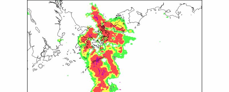
10 1-6 HOURS QPF STORM GROWTH & DISSIPATION PROBLEM SWIRLS Nowcast (top) actual (bottom) 1-hour 3-hour 6-hour 30 mm 60 mm 80 mm MRI/NIED/JMA March
11 BLENDING LE WITH NWP Nowcasting component LE 0-6 hr QPF by extending the linear extrapolation of radar echoes NWP component Non-hydrostatic Model (NHM) 0 6 hr QPF by 2-km non-hydrostatic numerical model 3DVAR, Doppler, dual-radar 3D wind, GPS/PWV, etc. +3DAR Spatial & intensity adjusted No temporal adjustment Dynamic-weighting 11
12 DUAL-DOPPLER 3D RADAR WINDS 3-dimensional wind components (u,v,w) are retrieved from the observed radial velocity from 2 radars via minimization of the cost function J = J + J + J + o b d s where J o = square of difference between the observed radial velocity and the radial velocity of the retrieved 3D radar wind field; J b = square of difference between the retrieved 3D radar wind field and the background; J d = anelastic mass constraint term; J s = smoothness constraint (Laplacian of wind components). J 1 km x 1 km horizontal resolution 2 6 km height in 0.5 km interval updated every 6 minute As pseudo-observations observations on the mesoscale flow features Shimizu, S., H. Uyeda, Q. Moteki, T. Maesaka, Y. Takaya, K. Akaeda, T. Kato, and M. Yoshizaka, 2008: Structure and formation mechanism on the 24 May 2000 supercell-like storm developing in a moist environment over the Kanto Plain, Japan. Mon. Wea. Rev., 136,


13 Radar retrieval winds at various levels Model 0300UTC Analysis 13 MRI/NIED/JMA March
14 Better simulate the Cross-system pattern with radar 3D wind assimilated T+4hr F/C Dual radar 3D wind assimilated T+4hr F/C Control No Dual radar 3D wind Actual 1hr rainfall 14


15 ASSIMILATION OF GPS/PWV T+5hr F/C GPS/PWV assimilated T+5hr F/C Control No GPS/PWV Actual 1hr rainfall Better QPF with GPS/PWV assimilated 15
16 PROBLEMS Assimilation of high resolution remote sensing data (radar Doppler wind, 3D wind, GPS/PWV, etc.) improved the forecast Blending LE and NWP (with phase-correction) improves the skill score, especially in the first 2 hours, but still far from satisfactory The model s storm growth/dissipation, timing, intensity need to be improved The model s uncertainty needs to be taken care of. Probabilistic approach? 16
17 EXPERIENCE IN PROBABILISTIC NOWCASTING 17


18 NOWCASTING OF CLOUD-TO-GROUND LIGHTNING FOR THE HONG KONG INTERNATIONAL AIRPORT RED/AMBER Lightning Alert Disseminated to users fully-automatic All ground operations have to stop and take measures to protect lives against lightning strikes Re-fueling, embarkment /disembarkment, baggage/cargo handling would be delayed bringing major disruption to airport operations -> high precise lightning alerting system
19 AIRPORT LIGHTNING WARNING LIGHT AND SIREN ALWS


20 ATLAS Weather Radar - Thunderstorm intensity and movement updated every minute LLIS network Cloud-to-Ground (CG) lightning location 20


21 ATLAS ALERT VIA INTERNET AND MOBILE Informative graphical product Simple texture message
 No casualty since the introduction of ATLAS")
22 TIME-LAGGED ENSEMBLE NOWCAST APPROACH POD > 90%, FAR < 10% (since 2008) No casualty since the introduction of ATLAS 22

23 PROBABILITY LIGHTNING NOWCAST FOR POWER COMPANY Objective: To forecast and alert the possibility of 3 or more power disruption events over 4 zones (overland) due to lightning in the next 2 hours HKO is requested to forecast the number of CGs in the next 2 hours, with uncertainty information provided North1 North2 East West MRI/NIED/JMA March
24 ENSEMBLE NOWCASTING APPROACH (CONCEPT BORROWED FROM ECMWF EPS) The uncertainty could emerge from motion field mixture of small scale and large scale fluctuation of motion vector with time storm growth and dissipation ensemble TREC (etrec) Varying the size of the box in the TREC correlation algorithm to find out different TREC wind fields 16 box sizes -> 16 TREC wind fields smaller box -> microscale movement larger box -> macroscale movement 24


25 16 TREC wind fields 19x19 21x21 23x x49 25
26 For the growth and dissipation, include trending: Linear trend Multiple linearly each of the 16 etrec members by a factor derived by the change of the no. of CG strokes in the past hour Nonlinear trend Multiple each of the 16 etrec members by following the change profile of the no. of CG strokes in the past 3 hours For the fluctuation of storm movement, include time-lagged ensemble by involving T and T-6min ensemble nowcasts to generate a grand ensemble grand (linear) ensemble nowcast = 16 (no trend) + 16 (T-0min linear trend) + 16 (T-6min linear trend) members = 48 members OR grand (nonlinear) ensemble nowcast = 16 (no trend) + 16 (T-0min nonlinear trend) + 16 (T-6min nonlinear trend) members = 48 members T linear trend T nonlinear trend 26

27 TECHNICAL FEASIBLE 1x superblade server, dual quadcore -> 16 threads running in parallel 48x ensemble members 16x notrend nowcasts -> 60sec 16x T-6 linear/nonlinear trend nowcasts -> 40sec 16x T-0 linear/nonlinear trend nowcasts -> 40sec statistics computation -> 20sec < 3 min => ENS update frequency (6 min) feasible 27


28 Lowest, highest quintile and the mean values Customer s feedback, "By having the alert service, we could mobilize our operation and emergency team early, and expedite power restoration in case any equipment fails due to lightning. At the same time, the lightning information could facilitate the company to dispatch the emergency crew more safely and efficiently." 28
29 GREATER CHALLENGES AVIATION REQUIREMENTS 29
30 30
31 AVIATION CONVECTION FORECAST IS A HIGHLY DEMANDING 4-DIMENSIONAL PROBLEM position, height and time Intensity, onset, longevity, probability, Trajectory-Based Especially important for busy/growing airports worldwide Not single effort of MET service close collaboration with ATM The Envisioned Aviation System and Nowcasting Requirements (Thursday)
")

32 Aviation Thunderstorm Nowcasting System (ATNS) Specific Forecast for waypoints 0-1 hour 0-1 hr forecast 32
33 OTHER NOWCASTING NEEDS FROM AVIATION COMMUNITY Besides convection Low level windshear Crosswind Low level turbulence Visibility (haze/dust, mist/fog) 33


34 ULTRA-HIGH RESOLUTION AVIATION MODEL WRF T+4 h forecast N.B. model forecast at a time lag of about 1.5 hr on the passage of squall line NHM T+4 h forecast MRI/NIED/JMA March 2012 x=600m 34


 and at 975 haps")
35 RAPIDS-NHM forecast for surface wind speed and wind direction (arrows) and gust (color shading in knots) RAPIDS-NHM forecast for wind speed (color) and wind direction (arrows) at 975 haps level 35
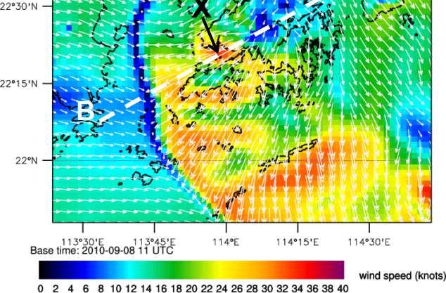
 and EPT (color,")

36 Vertical cross section along AB showing wind stomach (contour, unit in knots) and EPT (color, unit in K). Stomach contours are drawn with an interval of 3 knots for areas exceeding 22 knots. 36
37 IDENTIFIED IMPROVEMENT AREAS Modeling Higher density (spatial-temporal) observations Hi-Fi DA Spin-up/hot start Microphysics Dual-pol radar products life Initiation/growth/dissipation less difficult more difficult scale Storm sustainability storm dependent Multiscale interaction single cell, multicellular, mesoscale, organized systems (squall line, tropical cyclone) Probabilistic forecast How to generate useful probabilities? How to verify Impact? Nowcast How to better utilize NWP parameters? Deterministic and probabilistic How to blend with NWP? + Improved Nowcast How to fully utilize NWP data conceptual model (O-O) vs gridded, digital forecast Extreme /High Impact events matter call-to-action 37
38 IN SHORT We did see improvements, but Some weather phenomena are difficult to be nowcast than others, the limitation of LE (the limit of linear extrapolation) High resolution modeling is still far from satisfactory in terms of high impact weather Smart blending is required but how? Requires human knowledge to fill the insufficiency WSN August
39 39 Local Storm Characteristics (Scenarios)


40 RAINSTORM CHARACTERISTICS - FROM RADAR PERSPECTIVE - FROM SYNOPTIC FORCING PERSPECTIVE Radar perspective Rainstorm Phasebook SE, CP, TC, LS, SW, MTN, MTS
41 TO FIND THE TRUE TO VISIT CHRISTO REDENTOR but when I get closer I??? want to see more with patience and perseverance! 41
42 THANK YOU Q & A MRI/NIED/JMA March
Reprint 797. Development of a Thunderstorm. P.W. Li
 Reprint 797 Development of a Thunderstorm Nowcasting System in Support of Air Traffic Management P.W. Li AMS Aviation, Range, Aerospace Meteorology Special Symposium on Weather-Air Traffic Management Integration,
Application of NWP products and meteorological information processing system in Hong Kong
 Application of NWP products and meteorological information processing system in Hong Kong Y.S. Li Scientific Officer Hong Kong Observatory (ysli@hko.gov.hk) 7 million people Hong Kong ~1,100 km sq. Regional
2014 海峽兩岸暨香港地區航空氣象技術講座
 2014 海峽兩岸暨香港地區航空氣象技術講座 P W Li Vice chair Hong Kong Meteorological Society Senior Scientific Officer, Hong Kong Observatory pwli@hko.gov.hk www.meteorology.org.hk GUANGZHOU FIR HK FIR TAIPEI FIR About 276,000
AVIATION APPLICATIONS OF A NEW GENERATION OF MESOSCALE NUMERICAL WEATHER PREDICTION SYSTEM OF THE HONG KONG OBSERVATORY
 P452 AVIATION APPLICATIONS OF A NEW GENERATION OF MESOSCALE NUMERICAL WEATHER PREDICTION SYSTEM OF THE HONG KONG OBSERVATORY Wai-Kin WONG *1, P.W. Chan 1 and Ivan C.K. Ng 2 1 Hong Kong Observatory, Hong
7.17 RAPIDS A NEW RAINSTORM NOWCASTING SYSTEM IN HONG KONG
 7.17 RAPIDS A NEW RAINSTORM NOWCASTING SYSTEM IN HONG KONG Li Ping-Wah *, Wong Wai-Kin and Edwin S.T. Lai Hong Kong Observatory, 134A Nathan Road, Kowloon, Hong Kong 1. INTRODUCTION and the numerical forecast
Application of Nowcast Products to Real-time Warning of Hazardous Weather in Hong Kong
 Application of Nowcast Products to Real-time Warning of Hazardous Weather in Hong Kong M.C. Wong, E.S.T. Lai and P.W. Li Hong Kong Observatory, Hong Kong, China 1. INTRODUCTION Severe weather events may
Information Note on the Webpage for Significant Convection Monitoring and Forecast
 Information Note on the Webpage for Significant Convection Monitoring and Forecast The webpage displays both the real-time products for monitoring of significant convection and forecast products for significant
WMO Aviation Research Demonstration Project (AvRDP) and Seamless Trajectory Based Operation (TBO) PW Peter Li
 and Seamless Trajectory Based Operation (TBO) PW Peter Li") WMO Aviation Research Demonstration Project (AvRDP) and Seamless Trajectory Based Operation (TBO) PW Peter Li Hong Kong Observatory Chair, AvRDP SSC New Era of Aviation Industry WMO Congress XVI recognized
WMO Aviation Research Demonstration Project (AvRDP) and Seamless Trajectory Based Operation (TBO) PW Peter Li Hong Kong Observatory Chair, AvRDP SSC New Era of Aviation Industry WMO Congress XVI recognized
Utilising Radar and Satellite Based Nowcasting Tools for Aviation Purposes in South Africa. Erik Becker
 Utilising Radar and Satellite Based Nowcasting Tools for Aviation Purposes in South Africa Erik Becker Morné Gijben, Mary-Jane Bopape, Stephanie Landman South African Weather Service: Nowcasting and Very
Strategic Radar Enhancement Project (SREP) Forecast Demonstration Project (FDP) The future is here and now
 Forecast Demonstration Project (FDP) The future is here and now") Strategic Radar Enhancement Project (SREP) Forecast Demonstration Project (FDP) The future is here and now Michael Berechree National Manager Aviation Weather Services Australian Bureau of Meteorology
Strategic Radar Enhancement Project (SREP) Forecast Demonstration Project (FDP) The future is here and now Michael Berechree National Manager Aviation Weather Services Australian Bureau of Meteorology
Use of NWP and EPS Products in support of Location-specific Forecasts
 First International Workshop on Prevention and Migration of Meteorological Disasters in Southeast Asia Use of NWP and EPS Products in support of Location-specific Forecasts Edwin S.T. Lai Hong Kong Observatory
0-6 hour Weather Forecast Guidance at The Weather Company. Steven Honey, Joseph Koval, Cathryn Meyer, Peter Neilley The Weather Company
 1 0-6 hour Weather Forecast Guidance at The Weather Company Steven Honey, Joseph Koval, Cathryn Meyer, Peter Neilley The Weather Company TWC Forecasts: Widespread Adoption 2 0-6 Hour Forecast Details 3
Merging Nowcasting and NWP in Weather Warning Operations, with Special Reference to Landslides. C C Lam Hong Kong Observatory Hong Kong, China
 Merging Nowcasting and NWP in Weather Warning Operations, with Special Reference to Landslides C C Lam Hong Kong Observatory Hong Kong, China 1. Introduction In support of weather forecast and warning
Nowcasting techniques in use for severe weather operation in NMC/CMA
 WWRP NMRWG Buenos Aires Aug 2017 Nowcasting techniques in use for severe weather operation in NMC/CMA Jianjie WANG National Meteorological Center, CMA Cascading Weather Forecasting Process --- different
Preliminary results. Leonardo Calvetti, Rafael Toshio, Flávio Deppe and Cesar Beneti. Technological Institute SIMEPAR, Curitiba, Paraná, Brazil
 HIGH RESOLUTION WRF SIMULATIONS FOR WIND GUST EVENTS Preliminary results Leonardo Calvetti, Rafael Toshio, Flávio Deppe and Cesar Beneti Technological Institute SIMEPAR, Curitiba, Paraná, Brazil 3 rd WMO/WWRP
Application of microwave radiometer and wind profiler data in the estimation of wind gust associated with intense convective weather
 Application of microwave radiometer and wind profiler data in the estimation of wind gust associated with intense convective weather P W Chan 1 and K H Wong 2 1 Hong Kong Observatory, 134A Nathan Road,
DATA FUSION NOWCASTING AND NWP
 DATA FUSION NOWCASTING AND NWP Brovelli Pascal 1, Ludovic Auger 2, Olivier Dupont 1, Jean-Marc Moisselin 1, Isabelle Bernard-Bouissières 1, Philippe Cau 1, Adrien Anquez 1 1 Météo-France Forecasting Department
Probabilistic Quantitative Precipitation Forecasts for Tropical Cyclone Rainfall
 Probabilistic Quantitative Precipitation Forecasts for Tropical Cyclone Rainfall WOO WANG CHUN HONG KONG OBSERVATORY IWTCLP-III, JEJU 10, DEC 2014 Scales of Atmospheric Systems Advection-Based Nowcasting
International Civil Aviation Organization
 CNS/MET SG/14 IP/19 International Civil Aviation Organization FOURTEENTH MEETING OF THE COMMUNICATIONS/NAVIGATION/SURVEILL ANCE AND METEOROLOGY SUB-GROUP OF APANPIRG (CNS/MET SG/14) Jakarta, Indonesia,
AN EMPIRICAL MODEL FOR AERODROME WIND FORECASTING DURING THE PASSAGE OF TROPICAL CYCLONES
 P1.1 AN EMPIRICAL MODEL FOR AERODROME WIND FORECASTING DURING THE PASSAGE OF TROPICAL CYCLONES T. C. Cheung The Chinese University of Hong Kong Hong Kong China P. Cheung C. C. Lam * Hong Kong Observatory
Convective-scale NWP for Singapore
 Convective-scale NWP for Singapore Hans Huang and the weather modelling and prediction section MSS, Singapore Dale Barker and the SINGV team Met Office, Exeter, UK ECMWF Symposium on Dynamical Meteorology
OBJECTIVE CALIBRATED WIND SPEED AND CROSSWIND PROBABILISTIC FORECASTS FOR THE HONG KONG INTERNATIONAL AIRPORT
 P 333 OBJECTIVE CALIBRATED WIND SPEED AND CROSSWIND PROBABILISTIC FORECASTS FOR THE HONG KONG INTERNATIONAL AIRPORT P. Cheung, C. C. Lam* Hong Kong Observatory, Hong Kong, China 1. INTRODUCTION Wind is
Verification and performance measures of Meteorological Services to Air Traffic Management (MSTA)
") Verification and performance measures of Meteorological Services to Air Traffic Management (MSTA) Background Information on the accuracy, reliability and relevance of products is provided in terms of verification
Verification and performance measures of Meteorological Services to Air Traffic Management (MSTA) Background Information on the accuracy, reliability and relevance of products is provided in terms of verification
TIFS DEVELOPMENTS INSPIRED BY THE B08 FDP. John Bally, A. J. Bannister, and D. Scurrah Bureau of Meteorology, Melbourne, Victoria, Australia
 P13B.11 TIFS DEVELOPMENTS INSPIRED BY THE B08 FDP John Bally, A. J. Bannister, and D. Scurrah Bureau of Meteorology, Melbourne, Victoria, Australia 1. INTRODUCTION This paper describes the developments
Use of radar to detect weather
 2 April 2007 Welcome to the RAP Advisory Panel Meeting Use of radar to detect weather G. Brant Foote Brant Director Foote Rita Roberts Roelof Bruintjes Research Applications Program Radar principles Radio
A SMART SYSTEM FRAMEWORK ENABLING AN INNOVATIVE WEATHER AWARENESS SYSTEM FOR AIRPORTS AND BEYOND
 A SMART SYSTEM FRAMEWORK ENABLING AN INNOVATIVE WEATHER AWARENESS SYSTEM FOR AIRPORTS AND BEYOND Christian Schiefer, Sebastian Kauczok, Andre Weipert WSN16 WMO WWRP 4th International Symposium on Nowcasting
Aviation Reports, Forecasts and Warnings I
 Aviation Reports, Forecasts and Warnings I SPECI criteria Element Crosswind Supplementary information Special report in the SPECI code form crosswind based on the 10-minute mean wind changes from less
Xinhua Liu National Meteorological Center (NMC) of China Meteorological Administration (CMA)
 of China Meteorological Administration (CMA)") The short-time forecasting and nowcasting technology of severe convective weather for aviation meteorological services in China Xinhua Liu National Meteorological Center (NMC) of China Meteorological Administration
The short-time forecasting and nowcasting technology of severe convective weather for aviation meteorological services in China Xinhua Liu National Meteorological Center (NMC) of China Meteorological Administration
WWRP Implementation Plan Reporting AvRDP
 WWRP Implementation Plan Reporting AvRDP Please send you report to Paolo Ruti (pruti@wmo.int) and Sarah Jones (sarah.jones@dwd.de). High Impact Weather and its socio economic effects in the context of
Nowcasting Development and Users Need in Aviation
 Nowcasting Development and Users Need in Aviation Ping-Wah Peter LI Aviation Weather Services Branch, Hong Kong Observatory Working Group in Nowcasting Research Geneva, WMO 8-10 February 2011 Outline The
Smart use of Geographic Information System (GIS) platform for delivering weather information and nowcasting services
 platform for delivering weather information and nowcasting services") Smart use of Geographic Information System (GIS) platform for delivering weather information and nowcasting services C. K. Pan Hong Kong Observatory Hong Kong, China It is a world of beauty Source: Image
Smart use of Geographic Information System (GIS) platform for delivering weather information and nowcasting services C. K. Pan Hong Kong Observatory Hong Kong, China It is a world of beauty Source: Image
 Identification of Predictors for Nowcasting Heavy Rainfall In Taiwan --------------------- Part II: Storm Characteristics and Nowcasting Applications Challenges in Developing Nowcasting Applications for
Weather Systems III: Thunderstorms and Twisters
 Weather Systems III: Thunderstorms and Twisters Review 1. Definition of airmasses? Bergeron classification of air masses 2. Surface weather analysis: Station model, wind speed code, present weather 3.
Montréal, 7 to 18 July 2014
 INTERNATIONAL CIVIL AVIATION ORGANIZATION WORLD METEOROLOGICAL ORGANIZATION 6/5/14 Meteorology (MET) Divisional Meeting (2014) Commission for Aeronautical Meteorology Fifteenth Session Montréal, 7 to 18
A new mesoscale NWP system for Australia
 A new mesoscale NWP system for Australia www.cawcr.gov.au Peter Steinle on behalf of : Earth System Modelling (ESM) and Weather&Environmental Prediction (WEP) Research Programs, CAWCR Data Assimilation
NOAA s Severe Weather Forecasting System: HRRR to WoF to FACETS
 NOAA s Severe Weather Forecasting System: HRRR to WoF to FACETS David D NOAA / Earth System Research Laboratory / Global Systems Division Nowcasting and Mesoscale Research Working Group Meeting World Meteorological
AOMSUC-6 Training Event
 Effective use of high temporal and spatial resolution Himawari-8 data AOMSUC-6 Training Event Bodo Zeschke Australian Bureau of Meteorology Training Centre Australian VLab Centre of Excellence Content
The Nowcasting Demonstration Project for London 2012
 The Nowcasting Demonstration Project for London 2012 Susan Ballard, Zhihong Li, David Simonin, Jean-Francois Caron, Brian Golding, Met Office, UK Introduction The success of convective-scale NWP is largely
A HIGH-RESOLUTION RAPIDLY-UPDATED METEOROLOGICAL DATA ANALYSIS SYSTEM FOR AVIATION APPLICATIONS
 A HIGH-RESOLUTION RAPIDLY-UPDATED METEOROLOGICAL DATA ANALYSIS SYSTEM FOR AVIATION APPLICATIONS C. S. Lau *, J. T. K. Wan and M. C. Chu Department of Physics, The Chinese University of Hong Kong, Hong
Convective-scale Warn-on-Forecast The Future of Severe Weather Warnings in the USA?
 Convective-scale Warn-on-Forecast The Future of Severe Weather Warnings in the USA? David J. Stensrud Department of Meteorology The Pennsylvania State University Present Warning System: 2 March 2012 Warning
PAGASA s Expectations of New-generation Satellites for Hazard Monitoring
 Country Report Philippines PAGASA s Expectations of New-generation Satellites for Hazard Monitoring VICENTE P. PALCON, JR. (Assistant Weather Services Chief) Weather Division- PAGASA DOST Email: vppalconjr@pagasa.dost.gov.ph
Use of big data, crowdsourcing and GIS in assessment of weather-related impact
 Use of big data, crowdsourcing and GIS in assessment of weather-related impact HK (Photo courtesy : GFS) PAN Chi-kin, Hong Kong Observatory (Photo courtesy : Roy Liu/China Daily) November 2017, KMA/WMO
APEC Training Course on QPE / QPF. Part A - Overview. Rainfall-Related Related Warning Systems Practiced by a NMHS
 APEC Training Course on QPE / QPF Rainfall-Related Related Warning Systems Practiced by a NMHS Part A - Overview Linus H.Y. Yeung, Scientific Officer, Hong Kong Observatory 29 March 2012 Quezon City, Philippines
Meteorological CLEAR BUT PRESENT DANGER
 THE INTERNATIONAL REVIEW OF WEATHER, CLIMATE, AND HYDROLOGY TECHNOLOGIES AND SERVICES Meteorological AUGUST 2012 T E C H N O L O G Y I N T E R N A T I O N A L CLEAR BUT PRESENT DANGER The latest Earth
W.H. Leung, W.M. Ma and H.K. Yeung Hong Kong Observatory, Hong Kong, China
 322 THE APPLICATION OF LIGHTNING DENSITY MAP IN THE ANALYSIS OF A SEVERE RAINSTORM CASE IN HONG KONG W.H. Leung, W.M. Ma and H.K. Yeung Hong Kong Observatory, Hong Kong, China 1. INTRODUCTION On 22 July
Unique Vaisala Global Lightning Dataset GLD360 TM
 Unique Vaisala Global Lightning Dataset GLD360 TM / THE ONLY LIGHTNING DETECTION NETWORK CAPABLE OF DELIVERING HIGH-QUALITY DATA ANYWHERE IN THE WORLD GLD360 provides high-quality lightning data anywhere
Regional Hazardous Weather Advisory Centres (RHWACs)
") Regional Hazardous Weather Advisory Centres (RHWACs) The following outlines the criteria for the selection of RHWACs based on operational and functional requirements 1. Basic Principles The RHWAC must:
Regional Hazardous Weather Advisory Centres (RHWACs) The following outlines the criteria for the selection of RHWACs based on operational and functional requirements 1. Basic Principles The RHWAC must:
Deep Thunder. Local Area Precision Forecasting for Weather-Sensitive Business Operations (e.g. Electric Utility)
") 1 Deep Thunder Local Area Precision Forecasting for Weather-Sensitive Business Operations (e.g. Electric Utility) Dipl. Ing. Helmut Ludwar Chief Technologist Wien, im Oktober 2010 Forecasts for Weather-Sensitive
1 Deep Thunder Local Area Precision Forecasting for Weather-Sensitive Business Operations (e.g. Electric Utility) Dipl. Ing. Helmut Ludwar Chief Technologist Wien, im Oktober 2010 Forecasts for Weather-Sensitive
Have a better understanding of the Tropical Cyclone Products generated at ECMWF
 Objectives Have a better understanding of the Tropical Cyclone Products generated at ECMWF Learn about the recent developments in the forecast system and its impact on the Tropical Cyclone forecast Learn
The WMO Aviation Research & Demonstration Project (AvRDP) at Paris-CDG airport. Pauline Jaunet Météo-France
 at Paris-CDG airport. Pauline Jaunet Météo-France") The WMO Aviation Research & Demonstration Project (AvRDP) at Paris-CDG airport Pauline Jaunet Météo-France AvRDP focus points Aviation Research Demonstration Project Joint effort between CAS/WWRP and CaeM
The WMO Aviation Research & Demonstration Project (AvRDP) at Paris-CDG airport Pauline Jaunet Météo-France AvRDP focus points Aviation Research Demonstration Project Joint effort between CAS/WWRP and CaeM
Impact of different cumulus parameterizations on the numerical simulation of rain over southern China
 Impact of different cumulus parameterizations on the numerical simulation of rain over southern China P.W. Chan * Hong Kong Observatory, Hong Kong, China 1. INTRODUCTION Convective rain occurs over southern
Weather Analysis and Forecasting
 Weather Analysis and Forecasting An Information Statement of the American Meteorological Society (Adopted by AMS Council on 25 March 2015) Bull. Amer. Meteor. Soc., 88 This Information Statement describes
Research on Lightning Nowcasting and Warning System and Its Application
 Research on Lightning Nowcasting and Warning System and Its Application Wen Yao Chinese Academy of Meteorological Sciences Beijing, China yaowen@camscma.cn 2016.07 1 CONTENTS 1 2 3 4 Lightning Hazards
Seamless Probabilistic Forecasts for Civil Protection: from week to minutes
 Seamless Probabilistic Forecasts for Civil Protection: from week to minutes Yong Wang, Clemens Wastl, Andre Simon, Mihaly Szűcs ZAMG and HMS An EU project Bridging of Probabilistic Forecasts and Civil
Tropical Storm List
 Tropical Storm Email List http://tstorms.org/ tropical-storms@tstorms.org Tropical-Storms is a mailing list only for those who are professionally active in either the research or forecasting of tropical
Unique Vaisala Global Lightning Dataset GLD360 TM
 Unique Vaisala Global Lightning Dataset GLD360 TM / THE ONLY LIGHTNING DETECTION NETWORK CAPABLE OF DELIVERING SUCH HIGH-QUALITY DATA ANYWHERE IN THE WORLD GLD360 provides high-quality lightning data anywhere
Weather forecasts and warnings: Support for Impact based decision making
 Weather forecasts and warnings: Support for Impact based decision making Gerry Murphy, Met Éireann www.met.ie An Era of Change Climate and weather is changing Societal vulnerability is increasing The nature
Advances in Weather Technology
 Advances in Weather Technology Dr. G. Brant Foote National Center for Atmospheric Research 16 May 2001 NCAR Research Results in Aviation Weather Built on the foundation of the nation s long-standing investment
Fernando Prates. Evaluation Section. Slide 1
 Fernando Prates Evaluation Section Slide 1 Objectives Ø Have a better understanding of the Tropical Cyclone Products generated at ECMWF Ø Learn the recent developments in the forecast system and its impact
Challenges in providing effective flood forecasts and warnings
 Challenges in providing effective flood forecasts and warnings National Centre for Flood Research Inaugural Symposium Justin Robinson Bureau of Meteorology October 2018 Zero Lives Lost A key responsibility
icast: A Severe Thunderstorm Forecasting, Nowcasting and Alerting Prototype Focused on Optimization of the Human-Machine Mix
 icast: A Severe Thunderstorm Forecasting, Nowcasting and Alerting Prototype Focused on Optimization of the Human-Machine Mix 1Cloud Physics and Severe Weather Research Section, Toronto, ON 2Meteorological
Numerical Simulation of a Severe Thunderstorm over Delhi Using WRF Model
 International Journal of Scientific and Research Publications, Volume 5, Issue 6, June 2015 1 Numerical Simulation of a Severe Thunderstorm over Delhi Using WRF Model Jaya Singh 1, Ajay Gairola 1, Someshwar
New Meteorological Services Supporting ATM
 New Meteorological Services Supporting ATM Meteorological Services in the Terminal Area (MSTA)...providing MET services to support a move from Air Traffic Control (ATC) to more integrated and collaborative
Nesting and LBCs, Predictability and EPS
 Nesting and LBCs, Predictability and EPS Terry Davies, Dynamics Research, Met Office Nigel Richards, Neill Bowler, Peter Clark, Caroline Jones, Humphrey Lean, Ken Mylne, Changgui Wang copyright Met Office
The 5th Meeting of the Coordinating Group of the RA II WIGOS Satellite Project
 The 5th Meeting of the Coordinating Group of the RA II WIGOS Satellite Project 21 October, Vladivostok city, Russky Island, Russia Far Eastern Federal University Hong Kong, China Mr. C.K.So, Scientific
The Properties of Convective Clouds Over the Western Pacific and Their Relationship to the Environment of Tropical Cyclones
 The Properties of Convective Clouds Over the Western Pacific and Their Relationship to the Environment of Tropical Cyclones Principal Investigator: Dr. Zhaoxia Pu Department of Meteorology, University
Convection-Resolving NWP with WRF. Section coordinator Ming Xue University of Oklahoma
 Convection-Resolving NWP with WRF Section coordinator Ming Xue University of Oklahoma Convection-resolving NWP Is NWP that explicitly treats moist convective systems ranging from organized MCSs to individual
Regional Hazardous Weather Advisory Centres (RHWACs)
") Regional Hazardous Weather Advisory Centres (RHWACs) The following outlines the criteria for the selection of RHWACs based on operational and functional requirements 1. Basic Principles The RHWAC must:
Regional Hazardous Weather Advisory Centres (RHWACs) The following outlines the criteria for the selection of RHWACs based on operational and functional requirements 1. Basic Principles The RHWAC must:
Some Applications of WRF/DART
 Some Applications of WRF/DART Chris Snyder, National Center for Atmospheric Research Mesoscale and Microscale Meteorology Division (MMM), and Institue for Mathematics Applied to Geoscience (IMAGe) WRF/DART
Hong Kong Observatory Summer Placement Programme 2017
 Hong Kong Observatory Summer Placement Programme 2017 Training Programme : supervise the student. A mentor from the Hong Kong Observatory with relevant expertise will Training Period : 8 weeks, starting
The benefits and developments in ensemble wind forecasting
 The benefits and developments in ensemble wind forecasting Erik Andersson Slide 1 ECMWF European Centre for Medium-Range Weather Forecasts Slide 1 ECMWF s global forecasting system High resolution forecast
Wind data collected by a fixed-wing aircraft in the vicinity of a typhoon over the south China coastal waters
 Wind data collected by a fixed-wing aircraft in the vicinity of a typhoon over the south China coastal waters P.W. Chan * and K.K. Hon Hong Kong Observatory, Hong Kong, China Abstract: The fixed-wing aircraft
Developmental Testbed Center Visitor Program Final Report: Development and Application of 3-Dimensional Object Algorithms to High Resolution Forecasts
 Developmental Testbed Center Visitor Program Final Report: Development and Application of 3-Dimensional Object Algorithms to High Resolution Forecasts Adam J. Clark Cooperative Institute for Mesoscale
Guided Notes Weather. Part 2: Meteorology Air Masses Fronts Weather Maps Storms Storm Preparation
 Guided Notes Weather Part 2: Meteorology Air Masses Fronts Weather Maps Storms Storm Preparation The map below shows North America and its surrounding bodies of water. Country borders are shown. On the
1. INTRODUCTION * Figure 1. National Weather Service Storm Prediction Center (SPC) storm reports for December 1, 2006.
 storm reports for December 1, 2006.") P1.14 FORECAST ISSUES RELATED TO THE UNPRECEDENTED SEVERE AND HIGH WIND EVENT OF DECEMBER 2006 by Greg A. DeVoir* and Richard H. Grumm National Weather Service Office State College, PA 16803 1. INTRODUCTION
P1.14 FORECAST ISSUES RELATED TO THE UNPRECEDENTED SEVERE AND HIGH WIND EVENT OF DECEMBER 2006 by Greg A. DeVoir* and Richard H. Grumm National Weather Service Office State College, PA 16803 1. INTRODUCTION
High Resolution Numerical Modelling of a distinct extreme weather Cold Surges near Hong Kong region
 High Resolution Numerical Modelling of a distinct extreme weather Cold Surges near Hong Kong region Anupam Kumar, Edmond Lo and Adam Switzer Email: aeroanupam@yahoo.co.in; anupam002@ntu.edu.sg Nanyang
Progress of the Aviation Research Demonstration Project (AvRDP)
") Progress of the Aviation Research Demonstration Project (AvRDP) Peter PW Li NMRWG, member CAeM, ET/ASC, Core member Hong Kong Observatory, Hong Kong, China WMO, Geneva, Switzerland 25 November 2015 Objectives
Progress of the Aviation Research Demonstration Project (AvRDP) Peter PW Li NMRWG, member CAeM, ET/ASC, Core member Hong Kong Observatory, Hong Kong, China WMO, Geneva, Switzerland 25 November 2015 Objectives
3.23 IMPROVING VERY-SHORT-TERM STORM PREDICTIONS BY ASSIMILATING RADAR AND SATELLITE DATA INTO A MESOSCALE NWP MODEL
 3.23 IMPROVING VERY-SHORT-TERM STORM PREDICTIONS BY ASSIMILATING RADAR AND SATELLITE DATA INTO A MESOSCALE NWP MODEL Q. Zhao 1*, J. Cook 1, Q. Xu 2, and P. Harasti 3 1 Naval Research Laboratory, Monterey,
Judit Kerényi. OMSZ - Hungarian Meteorological Service, Budapest, Hungary. H-1525 Budapest, P.O.Box 38, Hungary.
 SATELLITE-DERIVED PRECIPITATION ESTIMATIONS DEVELOPED BY THE HYDROLOGY SAF PROJECT CASE STUDIES FOR THE INVESTIGATION OF THEIR ACCURACY AND FEATURES IN HUNGARY Judit Kerényi OMSZ - Hungarian Meteorological
Improving real time observation and nowcasting RDT. E de Coning, M Gijben, B Maseko and L van Hemert Nowcasting and Very Short Range Forecasting
 Improving real time observation and nowcasting RDT E de Coning, M Gijben, B Maseko and L van Hemert Nowcasting and Very Short Range Forecasting Introduction Satellite Application Facilities (SAFs) are
HAZARDOUS WEATHER 1. Dr. Julie Laity Geography 266
 HAZARDOUS WEATHER 1 Dr. Julie Laity Geography 266 Violent Weather Thunderstorms Atmospheric turbulence Lightning and thunder Hail Derechos Tornadoes Tornado measurement and science Tropical Cyclones Hurricanes
Use the terms from the following list to complete the sentences below. Each term may be used only once.
 Skills Worksheet Directed Reading Section: Air Masses Use the terms from the following list to complete the sentences below. Each term may be used only once. high pressure poles low pressure equator wind
Communicating uncertainty from short-term to seasonal forecasting
 Communicating uncertainty from short-term to seasonal forecasting MAYBE NO YES Jay Trobec KELO-TV Sioux Falls, South Dakota USA TV weather in the US Most TV weather presenters have university degrees and
Reprint 850. Within the Eye of Typhoon Nuri in Hong Kong in C.P. Wong & P.W. Chan
 Reprint 850 Remote Sensing Observations of the Subsidence Zone Within the Eye of Typhoon Nuri in Hong Kong in 2008 C.P. Wong & P.W. Chan 8 th International Symposium on Tropospheric Profiling: Integration
Briefing on the WMO Support to Viet Nam to cope with Typhoon Haiyan
 WMO Briefing on the WMO Support to Viet Nam to cope with Typhoon Haiyan A Case of WMO Emergency Response Typhoon Haiyan trajectory Background Typhoon Haiyan remained strong after devastating the Philippines
Maximizing the effectiveness and socio-economic benefits of weather products and services the Hong Kong Experience
 Maximizing the effectiveness and socio-economic benefits of weather products and services the Hong Kong Experience Queenie C.C. Lam Scientific Officer Hong Kong Observatory Hong Kong, China Meeting of
Emerging Aviation Weather Research at MIT Lincoln Laboratory*
 Emerging Aviation Weather Research at MIT Lincoln Laboratory* Haig 19 November 2015 *This work was sponsored by the Federal Aviation Administration under Air Force Contract No. FA8721-05-C-0002. Opinions,
Enhancing The Delivery Of Weather & Climate Information To End-Users. by Meteorological Services Division, NEA, Singapore
 Enhancing The Delivery Of Weather & Climate Information To End-Users by Meteorological Services Division, NEA, Singapore WMO RA V Seminar on Enhancing Service Delivery Kuala Lumpur, Malaysia, 2-6 April
Civil protection. (public, government and local authorities institutions)
") 23 Civil protection (public, government and local authorities institutions) Overview Statistics from the Centre for Research on the Epidemiology of Disasters (CRED) at the University of Leuven, Belgium,
23 Civil protection (public, government and local authorities institutions) Overview Statistics from the Centre for Research on the Epidemiology of Disasters (CRED) at the University of Leuven, Belgium,
SPEARFISH FIRE DEPARTMENT POLICIES AND PROCEDURES
 SPEARFISH FIRE DEPARTMENT POLICIES AND PROCEDURES Page 1 of 5 Volume: Operation Section: 20.00 Number: 20.09 Subject: Weather Watches, Warnings, Advisory s and Spotter Activation Date Issued: 28 March
Active Weather Threat Halloween Week Nor easter October 28 th 31 st 2012
 Active Weather Threat Halloween Week Nor easter October 28 th 31 st 2012 Prepared 1130 AM EDT Wednesday, October 24, 2012 Gary Szatkowski NOAA s NJ Forecast Office Weather.gov/phi Purpose of Briefing Briefing
Mesoscale meteorological models. Claire L. Vincent, Caroline Draxl and Joakim R. Nielsen
 Mesoscale meteorological models Claire L. Vincent, Caroline Draxl and Joakim R. Nielsen Outline Mesoscale and synoptic scale meteorology Meteorological models Dynamics Parametrizations and interactions
Asian THORPEX Implementation Plan
 Asian THORPEX Implementation Plan 1. Introduction This document is to describe the Implementation Plan of the Asian THORPEX, that the Asian THORPEX Regional Committee (ARC) approves. THORPEX was established
JMA Contribution to SWFDDP in RAV. (Submitted by Yuki Honda and Masayuki Kyouda, Japan Meteorological Agency) Summary and purpose of document
 Summary and purpose of document") WORLD METEOROLOGICAL ORGANIZATION COMMISSION FOR BASIC SYSTEMS OPAG on DPFS DPFS/RAV-SWFDDP-RSMT Doc. 7.1(1) (28.X.2010) SEVERE WEATHER FORECASTING AND DISASTER RISK REDUCTION DEMONSTRATION PROJECT (SWFDDP)
WORLD METEOROLOGICAL ORGANIZATION COMMISSION FOR BASIC SYSTEMS OPAG on DPFS DPFS/RAV-SWFDDP-RSMT Doc. 7.1(1) (28.X.2010) SEVERE WEATHER FORECASTING AND DISASTER RISK REDUCTION DEMONSTRATION PROJECT (SWFDDP)
Network Severe Weather Programme
 Network Severe Weather Programme David White Network Severe Weather programme Severe Weather is an EVENT with associated Uncertainty which requires Managing to protect the ATC environment & the integrity
Advances in weather and climate science
 Advances in weather and climate science Second ICAO Global Air Navigation Industry Symposium (GANIS/2) 11 to 13 December 2017, Montreal, Canada GREG BROCK Scientific Officer Aeronautical Meteorology Division
Challenges and Advances related to TC Rainfall Forecast. WOO Wang-chun Hong Kong Observatory IWTCLP-III, Jeju, Korea 10 Dec 2014
 Challenges and Advances related to TC Rainfall Forecast WOO Wang-chun Hong Kong Observatory IWTCLP-III, Jeju, Korea 10 Dec 2014 Working Group Composition Member Wallace HOGSETT Affiliations Weather Analytics,
Forecasting Flood Risk at the Flood Forecasting Centre, UK. Delft-FEWS User Days David Price
 Forecasting Flood Risk at the Flood Forecasting Centre, UK Delft-FEWS User Days 2012 David Price Overview of the Flood Forecasting Centre (FFC) What is the FFC? Partnership between the Met Office and Environment
WMO Aeronautical Meteorology Scientific Conference 2017
 Session 1 Science underpinning meteorological observations, forecasts, advisories and warnings 1.3 Aerodrome throughput 1.3.1 Wake vortex detection and prediction Frequent-output sub-kilometric NWP models
Joint Meeting of RA II WIGOS Project and RA V TT-SU on 11 October 2018 BMKG Headquarter Jakarta, Indonesia. Mrs. Sinthaly CHANTHANA
 Joint Meeting of RA II WIGOS Project and RA V TT-SU on 11 October 2018 BMKG Headquarter Jakarta, Indonesia Mrs. Sinthaly CHANTHANA Lao PDR Background Department of Meteorology and Hydrology ( DMH ) in