Seamless Probabilistic Forecasts for Civil Protection: from week to minutes
|
|
|
- Sherilyn O’Brien’
- 5 years ago
- Views:
Transcription


1 Seamless Probabilistic Forecasts for Civil Protection: from week to minutes Yong Wang, Clemens Wastl, Andre Simon, Mihaly Szűcs ZAMG and HMS
2 An EU project Bridging of Probabilistic Forecasts and Civil Protection Project: ; Website: Project aim Weather service and civil protection agency work together on: An innovative seamless probabilistic forecasting system in time (week to hour) and space (30km to 1km) tailored to civil protection
3 Seamless forecasts & actions ECMWF-EPS ~ 30 km resolution 15 days Civil Protection RESPONSE Potential severe weather event ALADIN-LAEF 11km resolution 3 days Civil Protection PREPARE More precise forecast AROME-EPS 2.5 km resolution 1,5 days Civil Protection GO-action Detailed forecast Ensemble INCA 1 km resolution 0-6 hours


4 Ensemble prediction systems ECMWF EPS 30km AROME EPS, AROME RUC and EN-INCA AROME EPS 2,5km EN-INCA 1 km AROME RUC 1,2km ALADIN-LAEF 11km
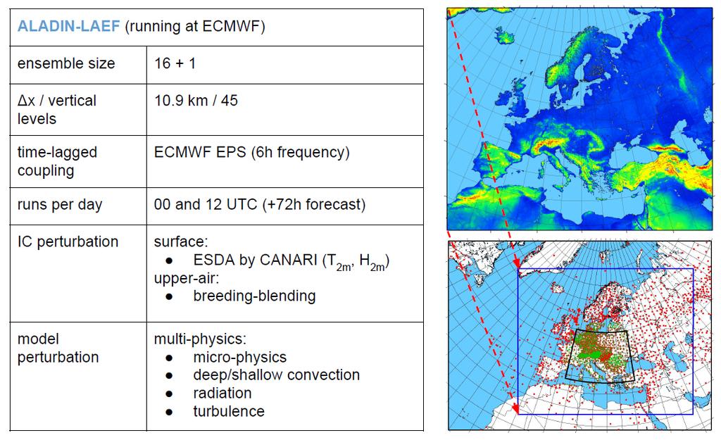
5 ALADIN-LAEF
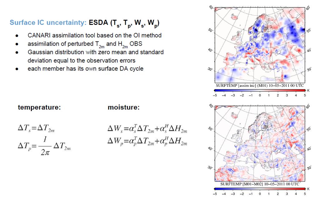
6 Surface perturbation
7 Atmospheric perturbation

8 Stochastic surface physics

 micro-physics shallow convection")
9 AROME-EPS AROME-EPS ensemble size Δx / vertical levels 2.5 km / 90 coupling runs per day IC perturbation model perturbation ECMWF EPS 2 / 4 runs (+30h forecast) EDA + EnJk +seda SPPT / psppt / ssppt: total tendencies (SPPT) micro-physics shallow convection turbulence


10 AROME-EPS: stochastic physics SPPT_global SPPT_adapt Influence of tapering function
 Shallow convection scheme (")
 dddd dddd = ( δtt 4 δtt, δrr 4 δtt 4 dddd dddd = δttii δtt ii=1 ) (1 + PP) dddd")
11 Total tendencies Radiation scheme AROME-EPS Partial tendencies Radiation scheme δtt 1 δtt Shallow convection scheme δtt 2 δtt, δrr 2 δtt, Turbulence scheme δuu 2, VV 2 δtt δtt 3 δtt, δrr 3 δtt, δuu 3, VV 3 δtt Microphysics scheme δtt 1 δtt (1 + PP) Shallow convection scheme ( δtt 2 δtt, δrr 2 δtt, δuu 2, VV 2 ) (1 + PP) δtt Turbulence scheme ( δtt 3 δtt, δrr 3 δtt, δuu 3, VV 3 ) (1 + PP) δtt Microphysics scheme 4 dddd dddd = δttii δtt ii=1 δtt 4 δtt, δrr 4 δtt (1 + PP) dddd dddd = ( δtt 4 δtt, δrr 4 δtt 4 dddd dddd = δttii δtt ii=1 ) (1 + PP) dddd dddd =
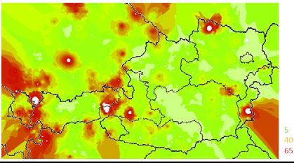
12 Ensemble INCA: Details EN-INCA Precipitation Analysis Nowcasting blending NWP Measurement error * Representation error * Radar error * Interpolation error * Extrapolation error Convective effects* NWP errors / Folie 12 uncertainties and/or Multi-Modelapproach * Measurement error* Representation error * Interpolation error * Ensemble background fields Error in NWP-trend -> LAEF Stochastical blending with LAEF NWP errors / uncertainties Perturbed META (Objectively Optimized Forecasting System) Analyse Nowcasting blending NWP Temperatur, wind
13 Estimation of radar error Error stdev
14 Ensmeble INCA From Error motion vectors to a nowcasting ensemble Error motion vector based on the error of previous motion vectors (e.g. last minutes) random variation of error motion vector (within Gaussian distr.) yields spread beginning at the very first forecast time step

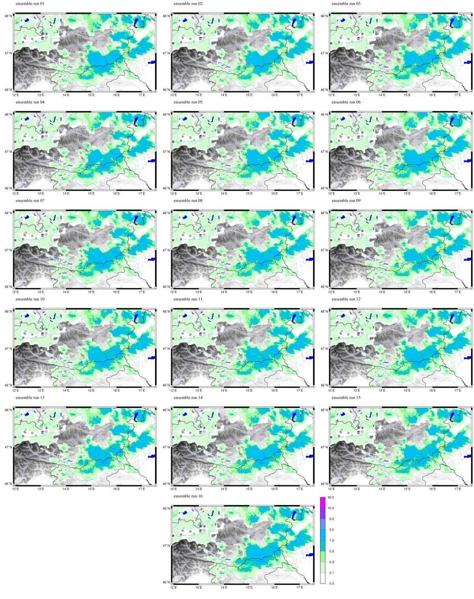
15 Examples of ensemble precipitation analysis
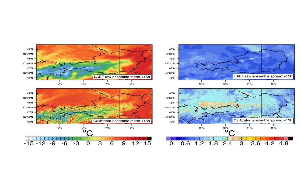
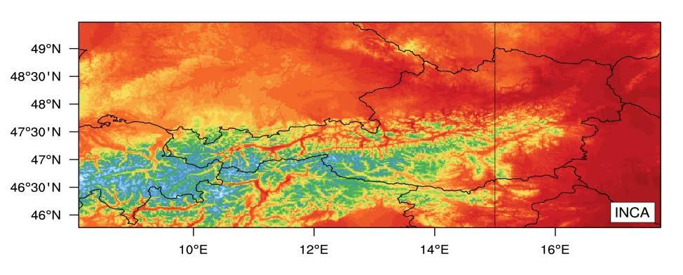
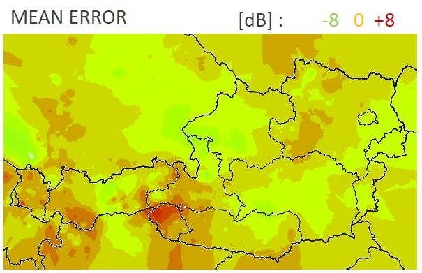
16 Statistical calibration

17 Webpage:
18 Webportal


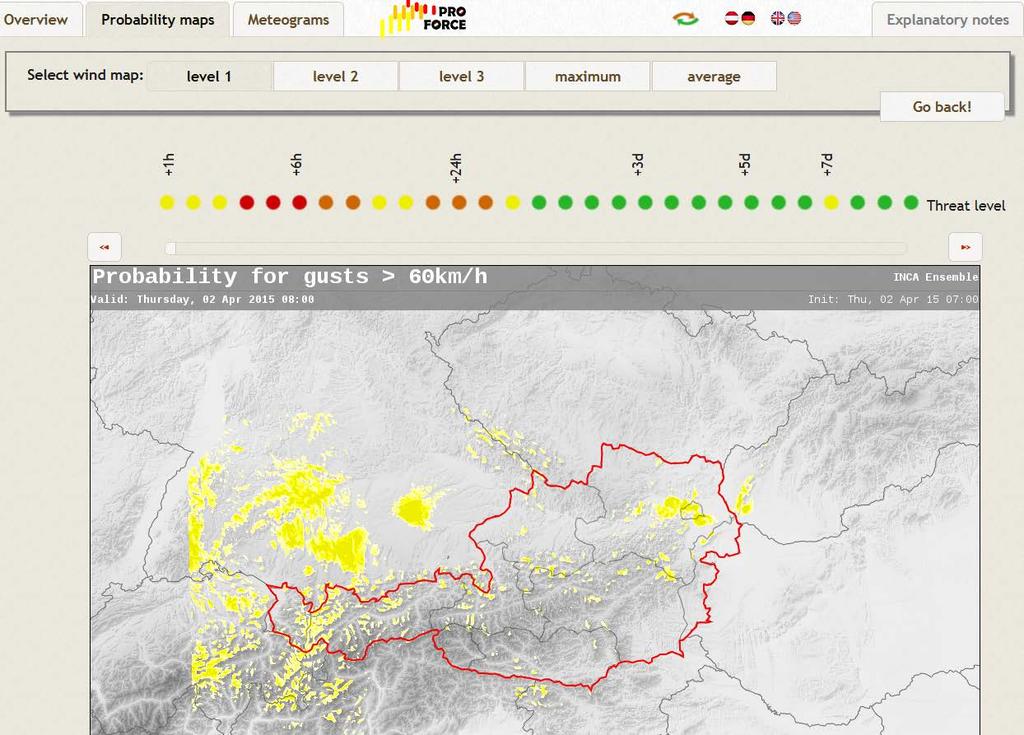
19 Threat by impact! Threat level: Impact definded by Civil Protection! - Combination of probability and impact - 3 warning levels: yellow, orange, red - Also the forecast time plays a role: The farther into the future the more severe a potential event has to be to reach threat level - General decay of forecast quality with increasing lead time is acknowledged in that way

.")
.")
20 Case studies Storm Niklas March 30 April days before the event: ECMWF-EPS First signals of a heavy storm event are already visible - first awareness actions in the forecasting centres. ECMWF forecast for Tuesday March 31, 18 UTC (Init UTC). Probability of gusts > 60km/h (up) and > 80km/h (right). ECMWF Meteogram for the capital city of St. Pölten (Init UTC). Some members exceed the 100km/h threshold for this location.


.")
21 Case studies Storm Niklas March 30 April days before the event: LAEF LAEF with a horizontal resolution of 11km includes more orographic details and confirms the forecast of ECMWF-EPS. CP receives first official warnings warning level was upgraded to orange. Local authorities are informed, first preparation actions are launched. Official warning of ZAMG issued on March UTC. Warning level was upgraded to orange (annuality < 3 times a year). LAEF forecast for Tuesday March 31, 18 UTC (Init UTC). Probability of gusts > 60km/h (upper), > 80km/h (middle) and > 100km/h (lower).


.")
22 Case studies Storm Niklas March 30 April day before the event: AROME-EPS Convection permitting EPS system AROME with 2.5km resolution and 48 hours forecasting range. Warning level orange was extended in time, basic warning was increased to 100km/h for the western parts of Lower Austria - final preparedness and prevention actions in CP are launched. AROME-EPS forecast for Tuesday March 31, 17 UTC (Init UTC). Probability of gusts > 60km/h (left), > 80km/h (middle) and Ensemble max. wind speed (right).

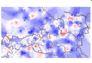
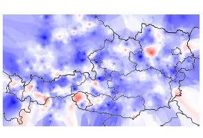
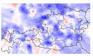
23 Case studies Storm Niklas March 30 April Nowcasting: Ensemble-INCA 1km resolution, 12h forecasting range, 15min update interval.warning level orange was extended in time, basic warning was increased to 100km/h for the western parts of Lower Austria - final preparedness and prevention actions in CP are launched. Ensemble-INCA forecast for Tuesday March 31, 14 UTC (Init UTC). Probability of gusts > 80km/h (left) and Ensemble max. wind speed (right).

 and Lower")
 shows the")
24 Case studies Storm Niklas March 30 April Feedback from Civil Protection - Very good wind forecasts of the seamless system - First awareness already several days in advance (much earlier than deterministic) - Additional information about uncertainty helped to focus the CP forces - Very high correspondence of warnings and number of operations Map of Upper Austria (left) and Lower Austria (middle) with marked operations due to strong wind. A comparison with the seamless forecast of the event (probability of exceeding 60km/h) shows the very high correspondence between operations and forecast.
, 3. North of the county (Lake Balaton) 4.")
25 A severe windstorm over Hungary 6 days before the event (Tuesday, 28 April 2015) Maximum gust (can exceed 90 km/h) ECMWF-EPS: Somogy county 1. Windstorm from NW 2. In the morning (peak at 09 UTC), 3. North of the county (Lake Balaton) 4. probability: 20-30% over 70km/h
 ECMWF-EPS: Change! In the evening (peak at 18 UTC)! probability: 50-60% over 70km/h!")
26 A severe windstorm over Hungary 4 days before the event (Tuesday, 28 April 2015) Maximum gust (70-80 km/h) ECMWF-EPS: Change! In the evening (peak at 18 UTC)! probability: 50-60% over 70km/h! Intensity weaker!
 Maximum gust (70-80 km/h) ECMWF-EPS: Probability: 40% over 70km/h!")

27 A severe windstorm over Hungary 3 days before the event (Tuesday, 28 April 2015) Maximum gust (70-80 km/h) ECMWF-EPS: Probability: 40% over 70km/h! No probability for 90km/h. Intensity even weaker! Weak thunderstorm! EPS Maximum for thunderstorm index Average intensity thunderstorms Showers, weak thunderstorms

28 A severe windstorm over Hungary 1 days before the event (Tuesday, 28 April 2015) Maximum gust (70 km/h) ALADIN-EPS: Change! not realistic Somogy county peak at 21 UTC! probability: 50% over 70km/h, but no > 90 km/h Intensity weaker! Shower, thunderstorm possible
 Maximum gust (70 km/h)")

29 A severe windstorm over Hungary The day of the event, in the morning (Tuesday, 28 April 2015) Maximum gust (70 km/h) ALADIN-EPS: No important change! The maximum gust even a bit weaker. Thunderstorm possible, weak to normal! EPS Maximum for thunderstorm index


30 The event 1400 UTC (Tuesday, 28 April 2015) INCA-EPS 3h nowcasts: Frontal precipitation approaching the area of Balaton, convective pre-frontal cells coming from south INCA EPS Wind analysis and nowcast: The wind will reach gale intensity at Balaton within 3h Analysis 3h forecast
 Wind analysis and nowcast:")

31 Caution! Day of the event 1700 UTC (Tuesday, 28 April 2015) Wind analysis and nowcast: The wind already turned at Balaton and intensified (70-90 km/h gusts) as planned. But the INCA nowcasts indicate that the wind can reach 100 km/h as well. This was not forecast by ECMWF and ALADIN-EPS!!! 100 km/h Analysis +3h Forecast


32 The event 1700 UTC (Tuesday, 28 April 2015) Observations confirmed! Windstorm at Balaton is already strong, the front reached the inner part of the County as well. The stable cold air inhibits convection. Heavy cells are only at the south. Siófok at Balaton: gale Kaposvár: after rain, windy roll-clouds waves


33 The event 2000 UTC (Tuesday, 28 April 2015) INCA-EPS 3h precipitation nowcasts: Heavy precipitation is aready out of the Somogy County. But the gale at Balaton further intensified!!! But INCA can sometimes overestimate the gust speed. We might verify it... EPS INCA maximum precipitation INCA wind analysis gusts > 110 km/h
 139 km/h 2000")
34 The event 2000 UTC (Tuesday, 28 April 2015) Wind gusts and average windspeed at Balatonőszöd (central basin and southern shore of the Lake) 139 km/h 2000 UTC
 Impact of : Damaged power lines on the")

35 IMPACT, after the event (Wednesday, 29 April 2015) Impact of : Damaged power lines on the railway at Balaton, buildings, ships in the harbour of Siófok. About 17 rescue actions required.
36 Summary and Follow up In the frame of PROFORCE, 4 weather and civil protection partners from Austria and Hungary have worked together on: An innovative seamless probabilistic forecasting system in time and space tailored to civil protection, for: improvements in the accuracy and timeliness of severe weather warnings improved preparedness and decision making procedures in civil protection agencies cooperation between weather and civil protection authorities transnational cooperation on warning Adaptation of the developed system for further use in other European countries and in other application area

37
Nowcasting systems and user applications; experiences from INCA, PROFORCE and ASIST
 Nowcasting systems and user applications; experiences from INCA, PROFORCE and André Simon (OMSZ) Máté Mile (OMSZ) Paul Gundersen(MetOffice) User applications Not standard NWP outputs, interdisciplinary
INCA CE: Integrating Nowcasting with crisis management and risk prevention in a transnational framework
 INCA CE: Integrating Nowcasting with crisis management and risk prevention in a transnational framework Yong Wang ZAMG, Austria This project is implemented through the CENTRAL EUROPE Programme co-financed
INCA-CE: The Challenge of Severe Weather Warnings. Yong Wang, ZAMG
 INCA-CE: The Challenge of Severe Weather Warnings Yong Wang, ZAMG Severe Weather and Impact The need of civil society and economy Save Life! Save Cost! Reduce Risks and impacts! The Challenge of Severe
LAM-EPS activities in RC LACE
 LAM-EPS activities in RC LACE Martin Belluš with contributions of M. Imrišek, Ch. Wittmann, C. Wastl, I. O. Plenković, M. Szűcs and E. Keresturi RC LACE Predictability Area - two main subjects: AROME-EPS
LAM-EPS activities in LACE
 LAM-EPS activities in LACE Martin Belluš with contributions of A. Trojáková, M. Szűcs, Ch. Wittmann, F. Weidle, Y. Wang, C. Wastl, S. Taşcu, J. Cedilnik and E. Keresturi AROME-EPS STOCHASTIC ALADIN-LAEF
Ingo Meirold-Mautner Yong Wang Alexander Kann Benedikt Bica Georg Pistotnik
 INCA-CE: The challenge of severe weather warnings Ingo Meirold-Mautner Yong Wang Alexander Kann Benedikt Bica Georg Pistotnik INCA Central Europe Integrated nowcasting for the Central European area BALTRAD
WMO/WWRP FDP: INCA CE
 WMO/WWRP FDP: INCA CE Yong Wang ZAMG, Austria This project is implemented through the CENTRAL EUROPE Programme co-financed by the ERDF INCA CE: implementation over Central Europe A Nowcasting Initiative
LAM-EPS activities in RC LACE
 LAM-EPS activities in RC LACE Martin Belluš with contributions of M. Szűcs, M. Dian, Ch. Wittmann, F. Weidle, Y. Wang, C. Wastl, S. Taşcu, R. Pomaga and E. Keresturi 1 Overview of activities (since last
Application and verification of ECMWF products 2012
 Application and verification of ECMWF products 2012 Instituto Português do Mar e da Atmosfera, I.P. (IPMA) 1. Summary of major highlights ECMWF products are used as the main source of data for operational
INCA-CE achievements and status
 INCA-CE achievements and status Franziska Strauss Yong Wang Alexander Kann Benedikt Bica Ingo Meirold-Mautner INCA Central Europe Integrated nowcasting for the Central European area This project is implemented
The Hungarian Meteorological Service has made
 ECMWF Newsletter No. 129 Autumn 11 Use of ECMWF s ensemble vertical profiles at the Hungarian Meteorological Service István Ihász, Dávid Tajti The Hungarian Meteorological Service has made extensive use
Integrating Nowcastingwith crisis management and risk prevention in a transnational framework (INCA-CE)
") Integrating Nowcastingwith crisis management and risk prevention in a transnational framework (INCA-CE) Yong Wang ZAMG, Austria This project is implemented through the CENTRAL EUROPE Programme co-financed
Integrating Nowcastingwith crisis management and risk prevention in a transnational framework (INCA-CE) Yong Wang ZAMG, Austria This project is implemented through the CENTRAL EUROPE Programme co-financed
AROME Nowcasting - tool based on a convective scale operational system
 AROME Nowcasting - tool based on a convective scale operational system RC - LACE stay report Supervisors (ZAMG): Yong Wang Florian Meier Christoph Wittmann Author: Mirela Pietrisi (NMA) 1. Introduction
Winter Storm Briefing #3 Monday Evening Wednesday Evening
 Winter Storm Briefing #3 Monday Evening Wednesday Evening Tuesday March 14, 2017 Disclaimer: The information contained within this briefing is time-sensitive. Do not use after 4AM Wednesday. Applies to
Xinhua Liu National Meteorological Center (NMC) of China Meteorological Administration (CMA)
 of China Meteorological Administration (CMA)") The short-time forecasting and nowcasting technology of severe convective weather for aviation meteorological services in China Xinhua Liu National Meteorological Center (NMC) of China Meteorological Administration
The short-time forecasting and nowcasting technology of severe convective weather for aviation meteorological services in China Xinhua Liu National Meteorological Center (NMC) of China Meteorological Administration
Developments towards multi-model based forecast product generation
 Developments towards multi-model based forecast product generation Ervin Zsótér Methodology and Forecasting Section Hungarian Meteorological Service Introduction to the currently operational forecast production
The benefits and developments in ensemble wind forecasting
 The benefits and developments in ensemble wind forecasting Erik Andersson Slide 1 ECMWF European Centre for Medium-Range Weather Forecasts Slide 1 ECMWF s global forecasting system High resolution forecast
Application and verification of ECMWF products 2009
 Application and verification of ECMWF products 2009 Hungarian Meteorological Service 1. Summary of major highlights The objective verification of ECMWF forecasts have been continued on all the time ranges
Road weather forecasts and MDSS in Slovakia
 ID: 0030 Road weather forecasts and MDSS in Slovakia M. Benko Slovak Hydrometeorological Institute (SHMI), Jeséniova 17, 83315 Bratislava, Slovakia Corresponding author s E-mail: martin.benko@shmu.sk ABSTRACT
JMA Contribution to SWFDDP in RAV. (Submitted by Yuki Honda and Masayuki Kyouda, Japan Meteorological Agency) Summary and purpose of document
 Summary and purpose of document") WORLD METEOROLOGICAL ORGANIZATION COMMISSION FOR BASIC SYSTEMS OPAG on DPFS DPFS/RAV-SWFDDP-RSMT Doc. 7.1(1) (28.X.2010) SEVERE WEATHER FORECASTING AND DISASTER RISK REDUCTION DEMONSTRATION PROJECT (SWFDDP)
WORLD METEOROLOGICAL ORGANIZATION COMMISSION FOR BASIC SYSTEMS OPAG on DPFS DPFS/RAV-SWFDDP-RSMT Doc. 7.1(1) (28.X.2010) SEVERE WEATHER FORECASTING AND DISASTER RISK REDUCTION DEMONSTRATION PROJECT (SWFDDP)
Recent progress in convective scale Arome NWP system and on-going research activities
 Recent progress in convective scale Arome NWP system and on-going research activities P. Brousseau, P. Chambon, G. Faure, R. Honnert, A. Mary, N. Merlet, Y. Seity, B. Vié, E. Wattrelot (presented by F.
Probabilistic Weather Prediction
 Probabilistic Weather Prediction George C. Craig Meteorological Institute Ludwig-Maximilians-Universität, Munich and DLR Institute for Atmospheric Physics Oberpfaffenhofen Summary (Hagedorn 2009) Nothing
Interaction of boundary-layer turbulence and convection in the AROME model: Preliminary results
 Interaction of boundary-layer turbulence and convection in the AROME model: Preliminary results Balázs Szintai Hungarian Meteorological Service COST ES0905 Workshop Cambridge, England 23 March 2010 Outline
Strategic Radar Enhancement Project (SREP) Forecast Demonstration Project (FDP) The future is here and now
 Forecast Demonstration Project (FDP) The future is here and now") Strategic Radar Enhancement Project (SREP) Forecast Demonstration Project (FDP) The future is here and now Michael Berechree National Manager Aviation Weather Services Australian Bureau of Meteorology
Strategic Radar Enhancement Project (SREP) Forecast Demonstration Project (FDP) The future is here and now Michael Berechree National Manager Aviation Weather Services Australian Bureau of Meteorology
South African Weather Service. Description of Public Weather and Warning Services. Tshepho Ngobeni. 18 November 2013
 South African Weather Service Description of Public Weather and Warning Services Tshepho Ngobeni 18 November 2013 SAWS-SWFDP_PRES_18-22_Nov_2013 1 Outline Forecasting Descriptions and Processes Severe
Seamless nowcasting. Open issues
 Federal Department of Home Affairs FDHA Federal Office of Meteorology and Climatology MeteoSwiss Seamless nowcasting INCA Open issues Pierre Eckert Matteo Buzzi, Marco Sassi, Guido della Bruna, Marco Gaia
Application and verification of ECMWF products 2015
 Application and verification of ECMWF products 2015 Instituto Português do Mar e da Atmosfera, I.P. 1. Summary of major highlights At Instituto Português do Mar e da Atmosfera (IPMA) ECMWF products are
Preliminary results. Leonardo Calvetti, Rafael Toshio, Flávio Deppe and Cesar Beneti. Technological Institute SIMEPAR, Curitiba, Paraná, Brazil
 HIGH RESOLUTION WRF SIMULATIONS FOR WIND GUST EVENTS Preliminary results Leonardo Calvetti, Rafael Toshio, Flávio Deppe and Cesar Beneti Technological Institute SIMEPAR, Curitiba, Paraná, Brazil 3 rd WMO/WWRP
ALADIN forecast experience in Croatia
 ALADIN forecast experience in Croatia Lidija Fustar and Tomislav Kozaric Meteorological and Hydrological Service ALADIN at DHMZ main source for the operational forecast at National Service of Croatia (along
Application and verification of ECMWF products 2017
 Application and verification of ECMWF products 2017 Finnish Meteorological Institute compiled by Weather and Safety Centre with help of several experts 1. Summary of major highlights FMI s forecasts are
Application and verification of the ECMWF products Report 2007
 Application and verification of the ECMWF products Report 2007 National Meteorological Administration Romania 1. Summary of major highlights The medium range forecast activity within the National Meteorological
Severe weather warnings at the Hungarian Meteorological Service: Developments and progress
 Severe weather warnings at the Hungarian Meteorological Service: Developments and progress István Ihász Hungarian Meteorological Service Edit Hágel Hungarian Meteorological Service Balázs Szintai Department
The convection-permitting COSMO-DE-EPS and PEPS at DWD
 Deutscher Wetterdienst The convection-permitting COSMO-DE-EPS and PEPS at DWD Detlev Majewski based on Chr. Gebhardt, S. Theis, M. Paulat, M. Buchhold and M. Denhard Deutscher Wetterdienst The model COSMO-DE
TC/PR/RB Lecture 3 - Simulation of Random Model Errors
 TC/PR/RB Lecture 3 - Simulation of Random Model Errors Roberto Buizza (buizza@ecmwf.int) European Centre for Medium-Range Weather Forecasts http://www.ecmwf.int Roberto Buizza (buizza@ecmwf.int) 1 ECMWF
Stochastic methods for representing atmospheric model uncertainties in ECMWF's IFS model
 Stochastic methods for representing atmospheric model uncertainties in ECMWF's IFS model Sarah-Jane Lock Model Uncertainty, Research Department, ECMWF With thanks to Martin Leutbecher, Simon Lang, Pirkka
Perspectives on EPS at EUMETNET and at AEMET
 Perspectives on EPS at EUMETNET and at AEMET Bartolomé Orfila 24th ALADIN Workshop & HIRLAM All Staff Meeting 7-11 April 2014, Romania OUTLINE What should be the content of the Project Proposal for the
ADL110B ADL120 ADL130 ADL140 How to use radar and strike images. Version
 ADL110B ADL120 ADL130 ADL140 How to use radar and strike images Version 1.00 22.08.2016 How to use radar and strike images 1 / 12 Revision 1.00-22.08.2016 WARNING: Like any information of the ADL in flight
Mesoscale meteorological models. Claire L. Vincent, Caroline Draxl and Joakim R. Nielsen
 Mesoscale meteorological models Claire L. Vincent, Caroline Draxl and Joakim R. Nielsen Outline Mesoscale and synoptic scale meteorology Meteorological models Dynamics Parametrizations and interactions
recent Météo-France work on AROME-EPS Robert Osinski & François Bouttier - CNRM, Toulouse
 recent Météo-France work on AROME-EPS Robert Osinski & François Bouttier - CNRM, Toulouse Evolution of the preoperational system Architecture New resolution & domain Coping with small ensemble size Space/Time
Aurora Bell*, Alan Seed, Ross Bunn, Bureau of Meteorology, Melbourne, Australia
 15B.1 RADAR RAINFALL ESTIMATES AND NOWCASTS: THE CHALLENGING ROAD FROM RESEARCH TO WARNINGS Aurora Bell*, Alan Seed, Ross Bunn, Bureau of Meteorology, Melbourne, Australia 1. Introduction Warnings are
Current Issues and Challenges in Ensemble Forecasting
 Current Issues and Challenges in Ensemble Forecasting Junichi Ishida (JMA) and Carolyn Reynolds (NRL) With contributions from WGNE members 31 th WGNE Pretoria, South Africa, 26 29 April 2016 Recent trends
Nowcasting for the London Olympics 2012 Brian Golding, Susan Ballard, Nigel Roberts & Ken Mylne Met Office, UK. Crown copyright Met Office
 Nowcasting for the London Olympics 2012 Brian Golding, Susan Ballard, Nigel Roberts & Ken Mylne Met Office, UK Outline Context MOGREPS-UK AQUM Weymouth Bay models Summary Forecasting System Generic Products
Application and verification of ECMWF products 2015
 Application and verification of ECMWF products 2015 Hungarian Meteorological Service 1. Summary of major highlights The objective verification of ECMWF forecasts have been continued on all the time ranges
Application and verification of ECMWF products 2017
 Application and verification of ECMWF products 2017 Slovenian Environment Agency ARSO; A. Hrabar, J. Jerman, V. Hladnik 1. Summary of major highlights We started to validate some ECMWF parameters and other
OBJECTIVE CALIBRATED WIND SPEED AND CROSSWIND PROBABILISTIC FORECASTS FOR THE HONG KONG INTERNATIONAL AIRPORT
 P 333 OBJECTIVE CALIBRATED WIND SPEED AND CROSSWIND PROBABILISTIC FORECASTS FOR THE HONG KONG INTERNATIONAL AIRPORT P. Cheung, C. C. Lam* Hong Kong Observatory, Hong Kong, China 1. INTRODUCTION Wind is
Application and verification of ECMWF products in Norway 2008
 Application and verification of ECMWF products in Norway 2008 The Norwegian Meteorological Institute 1. Summary of major highlights The ECMWF products are widely used by forecasters to make forecasts for
Probabilistic Winter Weather Nowcasting supporting Total Airport Management
 Probabilistic Winter Weather Nowcasting supporting Total Airport Management Jaakko Nuottokari* Finnish Meteorological Institute *With Heikki Juntti, Elena Saltikoff, Harri Hohti, Seppo Pulkkinen, Alberto
Low-end derecho of 19 August 2017
 Low-end derecho of 19 August 2017 By Richard H. Grumm and Charles Ross National Weather Service State College, PA 1. Overview A cluster of thunderstorms developed in eastern Ohio around 1800 UTC on 19
Nesting and LBCs, Predictability and EPS
 Nesting and LBCs, Predictability and EPS Terry Davies, Dynamics Research, Met Office Nigel Richards, Neill Bowler, Peter Clark, Caroline Jones, Humphrey Lean, Ken Mylne, Changgui Wang copyright Met Office
At the start of the talk will be a trivia question. Be prepared to write your answer.
 Operational hydrometeorological forecasting activities of the Australian Bureau of Meteorology Thomas Pagano At the start of the talk will be a trivia question. Be prepared to write your answer. http://scottbridle.com/
1. INTRODUCTION * Figure 1. National Weather Service Storm Prediction Center (SPC) storm reports for December 1, 2006.
 storm reports for December 1, 2006.") P1.14 FORECAST ISSUES RELATED TO THE UNPRECEDENTED SEVERE AND HIGH WIND EVENT OF DECEMBER 2006 by Greg A. DeVoir* and Richard H. Grumm National Weather Service Office State College, PA 16803 1. INTRODUCTION
P1.14 FORECAST ISSUES RELATED TO THE UNPRECEDENTED SEVERE AND HIGH WIND EVENT OF DECEMBER 2006 by Greg A. DeVoir* and Richard H. Grumm National Weather Service Office State College, PA 16803 1. INTRODUCTION
Heavy Rainfall Event of June 2013
 Heavy Rainfall Event of 10-11 June 2013 By Richard H. Grumm National Weather Service State College, PA 1. Overview A 500 hpa short-wave moved over the eastern United States (Fig. 1) brought a surge of
MSG FOR NOWCASTING - EXPERIENCES OVER SOUTHERN AFRICA
 MSG FOR NOWCASTING - EXPERIENCES OVER SOUTHERN AFRICA Estelle de Coning and Marianne König South African Weather Service, Private Bag X097, Pretoria 0001, South Africa EUMETSAT, Am Kavalleriesand 31, D-64295
Utilising Radar and Satellite Based Nowcasting Tools for Aviation Purposes in South Africa. Erik Becker
 Utilising Radar and Satellite Based Nowcasting Tools for Aviation Purposes in South Africa Erik Becker Morné Gijben, Mary-Jane Bopape, Stephanie Landman South African Weather Service: Nowcasting and Very
Application of ALADIN/AROME at the Hungarian Meteorological Service
 ORSZÁGOS METEOROLÓGIAI SZOLGÁLAT Application of ALADIN/AROME at the Hungarian Meteorological Service Balázs Szintai Head, Unit of Methodology Development Host presentation at the ALADIN 20 th General Assembly
How ECMWF has addressed requests from the data users
 How ECMWF has addressed requests from the data users David Richardson Head of Evaluation Section, Forecast Department, ECMWF David.richardson@ecmwf.int ECMWF June 14, 2017 Overview Review the efforts made
FLORA: FLood estimation and forecast in complex Orographic areas for Risk mitigation in the Alpine space
 Natural Risk Management in a changing climate: Experiences in Adaptation Strategies from some European Projekts Milano - December 14 th, 2011 FLORA: FLood estimation and forecast in complex Orographic
Application and verification of ECMWF products 2016
 Application and verification of ECMWF products 2016 Icelandic Meteorological Office (www.vedur.is) Bolli Pálmason and Guðrún Nína Petersen 1. Summary of major highlights Medium range weather forecasts
AROME-EPS development in Météo-France
 AROME-EPS development in Météo-France Int.Conf.Ens.Methods Toulouse, 15 Nov 2012 francois.bouttier@meteo.fr collaborators: Olivier Nuissier, Laure Raynaud, Benoît Vié Ensemble setup Boundary conditions
FLOOD/SCS EVENT, APRIL 28 MAY 4
 REPORT DATE: May 4, 2017 EVENT DATE: April 28-May 4, 2017 FLOOD/SCS EVENT, APRIL 28 MAY 4 Event Summary General Significant Flood Outlook. SOURCE: National Weather Service. A significant severe thunderstorm
WG4: interpretation and applications
 Federal Department of Home Affairs FDHA Federal Office of Meteorology and Climatology MeteoSwiss WG4: interpretation and applications Pierre Eckert MeteoSwiss, Geneva Topics FIELDEXTRA presentation by
On the use of radar rainfall estimates and nowcasts in an operational heavy rainfall warning service
 On the use of radar rainfall estimates and nowcasts in an operational heavy rainfall warning service Alan Seed, Ross Bunn, Aurora Bell Bureau of Meteorology Australia The Centre for Australian Weather
Model Output Statistics (MOS)
") Model Output Statistics (MOS) Numerical Weather Prediction (NWP) models calculate the future state of the atmosphere at certain points of time (forecasts). The calculation of these forecasts is based on
Model Output Statistics (MOS) Numerical Weather Prediction (NWP) models calculate the future state of the atmosphere at certain points of time (forecasts). The calculation of these forecasts is based on
Denver International Airport MDSS Demonstration Verification Report for the Season
 Denver International Airport MDSS Demonstration Verification Report for the 2015-2016 Season Prepared by the University Corporation for Atmospheric Research Research Applications Division (RAL) Seth Linden
LAMEPS activities at the Hungarian Meteorological Service. Hungarian Meteorological Service
 LAMEPS activities at the Hungarian Meteorological Service Edit Hágel Presented by András Horányi Hungarian Meteorological Service 1 2 Outline of the talk Motivation and background Sensitivity experiments
0-6 hour Weather Forecast Guidance at The Weather Company. Steven Honey, Joseph Koval, Cathryn Meyer, Peter Neilley The Weather Company
 1 0-6 hour Weather Forecast Guidance at The Weather Company Steven Honey, Joseph Koval, Cathryn Meyer, Peter Neilley The Weather Company TWC Forecasts: Widespread Adoption 2 0-6 Hour Forecast Details 3
Weather Briefing. Coastal Storm Monday-Wednesday Dec 8-10, National Weather Service. Prepared 12/8/14 6:30 AM
 Weather Briefing Coastal Storm Monday-Wednesday Dec 8-10, 2014 National Weather Service http://www.weather.gov/nyc Prepared 12/8/14 6:30 AM Overview of Potential Hazards A strong low pressure system will
High Resolution Numerical Weather Prediction for High Impact and Extreme Weather Events in 2014 across Southern California
 High Resolution Numerical Weather Prediction for High Impact and Extreme Weather Events in 2014 across Southern California Alex Tardy Alexander.Tardy@noaa.gov NWS San Diego Warning Coordination Meteorologist
The ECMWF Extended range forecasts
 The ECMWF Extended range forecasts Laura.Ferranti@ecmwf.int ECMWF, Reading, U.K. Slide 1 TC January 2014 Slide 1 The operational forecasting system l High resolution forecast: twice per day 16 km 91-level,
FLASH FLOOD FORECASTING AND EARLY WARNING IN SLOVENIA. Sašo Petan Hydrological Forecast Department, Slovenian Environment Agency (ARSO)
") REPUBLIC OF S LOVE NIA MINIS TR Y OF THE E NVIR ONME NT AND S PATIAL PALNNING SLOVENIAN ENVIRONMENT AGENCY FLASH FLOOD FORECASTING AND EARLY WARNING IN SLOVENIA Sašo Petan Hydrological Forecast Department,
REPUBLIC OF S LOVE NIA MINIS TR Y OF THE E NVIR ONME NT AND S PATIAL PALNNING SLOVENIAN ENVIRONMENT AGENCY FLASH FLOOD FORECASTING AND EARLY WARNING IN SLOVENIA Sašo Petan Hydrological Forecast Department,
Deutscher Wetterdienst
 Deutscher Wetterdienst Limited-area ensembles: finer grids & shorter lead times Susanne Theis COSMO-DE-EPS project leader Deutscher Wetterdienst Thank You Neill Bowler et al. (UK Met Office) Andras Horányi
C. Gebhardt, S. Theis, R. Kohlhepp, E. Machulskaya, M. Buchhold. developers of KENDA, ICON-EPS, ICON-EDA, COSMO-D2, verification
 Convective-scale EPS at DWD status, developments & plans C. Gebhardt, S. Theis, R. Kohlhepp, E. Machulskaya, M. Buchhold developers of KENDA, ICON-EPS, ICON-EDA, COSMO-D2, verification 1 Outline new operational
State of the art of wind forecasting and planned improvements for NWP Helmut Frank (DWD), Malte Mülller (met.no), Clive Wilson (UKMO)
, Malte Mülller (met.no), Clive Wilson (UKMO)") State of the art of wind forecasting and planned improvements for NWP Helmut Frank (DWD), Malte Mülller (met.no), Clive Wilson (UKMO) thanks to S. Bauernschubert, U. Blahak, S. Declair, A. Röpnack, C.
State of the art of wind forecasting and planned improvements for NWP Helmut Frank (DWD), Malte Mülller (met.no), Clive Wilson (UKMO) thanks to S. Bauernschubert, U. Blahak, S. Declair, A. Röpnack, C.
Behind the Climate Prediction Center s Extended and Long Range Outlooks Mike Halpert, Deputy Director Climate Prediction Center / NCEP
 Behind the Climate Prediction Center s Extended and Long Range Outlooks Mike Halpert, Deputy Director Climate Prediction Center / NCEP September 2012 Outline Mission Extended Range Outlooks (6-10/8-14)
Judit Kerényi. OMSZ-Hungarian Meteorological Service P.O.Box 38, H-1525, Budapest Hungary Abstract
 Comparison of the precipitation products of Hydrology SAF with the Convective Rainfall Rate of Nowcasting-SAF and the Multisensor Precipitation Estimate of EUMETSAT Judit Kerényi OMSZ-Hungarian Meteorological
Winter Weather. National Weather Service Buffalo, NY
 Winter Weather National Weather Service Buffalo, NY Average Seasonal Snowfall SNOWFALL = BIG IMPACTS School / government / business closures Airport shutdowns/delays Traffic accidents with injuries/fatalities
Austria (ZAMG) Implementation and development of AROME. Upgrade ALADIN-LAEF. Research on land surface data assimilation, e.g. ASCAT.
 Implementation and development of AROME. Upgrade ALADIN-LAEF. Research on land surface data assimilation, e.g. ASCAT.") Austria (ZAMG) Implementation and development of AROME Upgrade ALADIN-LAEF Research on land surface data assimilation, e.g. ASCAT. Belgium (RMI) Multi-scale behavior of ALARO-0 for extreme summer precipitation
Austria (ZAMG) Implementation and development of AROME Upgrade ALADIN-LAEF Research on land surface data assimilation, e.g. ASCAT. Belgium (RMI) Multi-scale behavior of ALARO-0 for extreme summer precipitation
Diabatic processes and the structure of the warm conveyor belt
 2 nd European Windstorm Workshop Leeds, 3-4 September 2012 Diabatic processes and the structure of the warm conveyor belt Oscar Martínez-Alvarado J. Chagnon, S. Gray, R. Plant, J. Methven Department of
Assimilation of radar reflectivity
 Assimilation of radar reflectivity Axel Seifert Deutscher Wetterdienst, Offenbach, Germany Convective-scale NWP at DWD: Plans for 2020 Storm-scale ICON-RUC-EPS: hourly 12h ensemble forecasts based on short
Flood Forecasting. Fredrik Wetterhall European Centre for Medium-Range Weather Forecasts
 Flood Forecasting Fredrik Wetterhall (fredrik.wetterhall@ecmwf.int) European Centre for Medium-Range Weather Forecasts Slide 1 Flooding a global challenge Number of floods Slide 2 Flooding a global challenge
Severe Weather Potential for Southeast Texas
 Severe Weather Potential for Southeast Texas Dan Reilly, Kent Prochazka, Scott Overpeck National Weather Service Houston/Galveston 10 am Synopsis Storm to likely bring severe weather to Southeast Texas
ECMWF products to represent, quantify and communicate forecast uncertainty
 ECMWF products to represent, quantify and communicate forecast uncertainty Using ECMWF s Forecasts, 2015 David Richardson Head of Evaluation, Forecast Department David.Richardson@ecmwf.int ECMWF June 12,
István Ihász, Máté Mile and Zoltán Üveges Hungarian Meteorological Service, Budapest, Hungary
 Comprehensive study of the calibrated EPS products István Ihász, Máté Mile and Zoltán Üveges Hungarian Meteorological Service, Budapest, Hungary 1. Introduction Calibration of ensemble forecasts is a new
Catalysing Innovation in Weather Science - the role of observations and NWP in the World Weather Research Programme
 Catalysing Innovation in Weather Science - the role of observations and NWP in the World Weather Research Programme Estelle de Coning, Paolo Ruti, Julia Keller World Weather Research Division The World
DETECTION AND FORECASTING - THE CZECH EXPERIENCE
 1 STORM RAINFALL DETECTION AND FORECASTING - THE CZECH EXPERIENCE J. Danhelka * Czech Hydrometeorological Institute, Prague, Czech Republic Abstract Contribution presents the state of the art of operational
Convection Nowcasting Products Available at the Army Test and Evaluation Command (ATEC) Ranges
 Ranges") Convection Nowcasting Products Available at the Army Test and Evaluation Command (ATEC) Ranges Cathy Kessinger National Center for Atmospheric Research (NCAR), Boulder, CO with contributions from: Wiebke
Convection Nowcasting Products Available at the Army Test and Evaluation Command (ATEC) Ranges Cathy Kessinger National Center for Atmospheric Research (NCAR), Boulder, CO with contributions from: Wiebke
Thunderstorm-Scale EnKF Analyses Verified with Dual-Polarization, Dual-Doppler Radar Data
 Thunderstorm-Scale EnKF Analyses Verified with Dual-Polarization, Dual-Doppler Radar Data David Dowell and Wiebke Deierling National Center for Atmospheric Research, Boulder, CO Ensemble Data Assimilation
U.S. WIND, SCS, FLOOD, WINTER WEATHER
 U.S. WIND, SCS, FLOOD, WINTER WEATHER The threat continues for strong winds, heavy snow, heavy rain and severe thunderstorms according to the U.S. National Weather Service (NWS). The threat comes with
The analysis and nowcasting system INCA. T. Haiden, A. Kann, K. Stadlbacher, G. Pistotnik, M. Steinheimer, F. Wimmer, C. Wittmann
 The analysis and nowcasting system INCA T. Haiden, A. Kann, K. Stadlbacher, G. Pistotnik, M. Steinheimer, F. Wimmer, C. Wittmann Contents INCA system overview INCA performance Applications & cooperations
Exploring stochastic model uncertainty representations
 Exploring stochastic model uncertainty representations with relevance to the greyzone Sarah-Jane Lock, Martin Leutbecher, Peter Bechtold, Richard Forbes Research Department, ECMWF ECMWF November 15, 2017
Weather forecasts and warnings: Support for Impact based decision making
 Weather forecasts and warnings: Support for Impact based decision making Gerry Murphy, Met Éireann www.met.ie An Era of Change Climate and weather is changing Societal vulnerability is increasing The nature
Montréal, 7 to 18 July 2014
 INTERNATIONAL CIVIL AVIATION ORGANIZATION WORLD METEOROLOGICAL ORGANIZATION 6/5/14 Meteorology (MET) Divisional Meeting (2014) Commission for Aeronautical Meteorology Fifteenth Session Montréal, 7 to 18
Convective-scale NWP for Singapore
 Convective-scale NWP for Singapore Hans Huang and the weather modelling and prediction section MSS, Singapore Dale Barker and the SINGV team Met Office, Exeter, UK ECMWF Symposium on Dynamical Meteorology
Application and verification of ECMWF products 2011
 Application and verification of ECMWF products 2011 National Meteorological Administration 1. Summary of major highlights Medium range weather forecasts are primarily based on the results of ECMWF and
Severe Weather Watches, Advisories & Warnings
 Severe Weather Watches, Advisories & Warnings Tornado Watch Issued by the Storm Prediction Center when conditions are favorable for the development of severe thunderstorms and tornadoes over a larger-scale
Probabilistic weather hazard forecast guidance for transoceanic flights based on merged global ensemble forecasts
 Probabilistic weather hazard forecast guidance for transoceanic flights based on merged global ensemble forecasts Matthias Steiner National Center for Atmospheric Research, Boulder, Colorado, USA msteiner@ucar.edu
Dijana Klarić RC LACE Program Manager
 Dijana Klarić RC LACE Program Manager www.rclace.eu 10-13 October 2011 33rd EWGLAM, Tallinn, Estonia 1 2011 report LACE Projects () 3y summary 2011 R&D highlights ~ 2012 plans LACE future ALARO phy 5km
Flood Risk Forecasts for England and Wales: Production and Communication
 Staines Surrey Flood Risk Forecasts for England and Wales: Production and Communication Jon Millard UEF 2015 : Quantifying and Communicating Uncertainty FFC What is the FFC? Successful partnership between
IWT Scenario 2 Integrated Warning Team Workshop National Weather Service Albany, NY October 31, 2014
 IWT Scenario 2 Integrated Warning Team Workshop National Weather Service Albany, NY October 31, 2014 09 10 11 12 13 Scenario 2 Timeline December 9-13 Tue Wed Thu Fri Sat Tue, Dec. 9 @ 5 am 2014 2014 2014
Description of the case study
 Description of the case study During the night and early morning of the 14 th of July 011 the significant cloud layer expanding in the West of the country and slowly moving East produced precipitation