Aviation Reports, Forecasts and Warnings I
|
|
|
- Holly Knight
- 6 years ago
- Views:
Transcription
1 Aviation Reports, Forecasts and Warnings I
2 SPECI criteria Element Crosswind Supplementary information Special report in the SPECI code form crosswind based on the 10-minute mean wind changes from less than 20 knots to 20 knots or more and vice versa (operational limits of aircrafts following Annex 3) Vicinity: approach and climb out area taken to be 13 km


3 Speci Alert

4
5 Artificial gusts due to aircraft operations Jet engine blasts More than just hot air It can cause damage and upsets during ground operations if encountered at close range Almost every commercial jet operating manual has a diagram showing the aircraft's jet blast "damage profile" as measured from the tail.

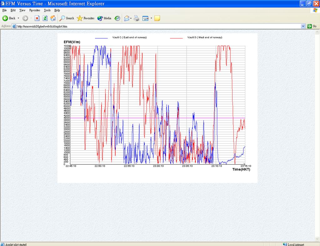
6 Effect of jet blast on surface wind observations
7 Artificial gusts due to aircraft operations (cont) Wake vortices All aircrafts produce wake vortices when in flight The strongest vortices are produced by heavy aircraft, flying slowly, in a clean configuration During takeoff and landing, the vortices sink toward the ground and move laterally away from the runway when the wind is calm. A 3 to 5 knot crosswind will tend to keep the upwind vortex in the runway area and may cause the downwind vortex to drift toward another runway

8 Effect of wake vortex on surface wind observations 1


9 Effect of wake vortex on surface wind observations 2
10 How to discriminate artificial gusts from natural gusts?
11 A method Frequency distribution of normalized wind speed u n = (u( max U) /σ / u on a day with no aircraft operations confirms to a normal distribution This holds for all types of weather, including thunderstorms Tests indicated that gusts are likely to be artificial with u n > 5
12 Comparing u and u n
13 Program developed by HKO Extract and prepare 3-second 3 and 10-minute mean wind speeds from AMOS. Calculate normalized 3- second mean wind speed If within the 10-minute observation reporting period: a point with normalized 3-second mean wind speed greater than 5, the corresponding difference between the 3-second 3 and 10- minute mean winds is greater than 5 m/s, the corresponding 10-minute mean wind speed is greater than 5.0 m/s and the standard deviation is greater than 0.5 The point will be marked suspicious and will be shown
14 Limitation Unable to detect False alarm
 Photo taken at")
15 Haze on 20 Nov 2002 (visibility down to 4200m at 1340H) Photo taken at 1340H

16

17 spreading of haze

18

19 Fog edging towards HKIA
20 Quick Reference of Reflectivity and Rainfall Rate Reflectivity (dbz) Rainfall Rate (mm/h)

21 Correlation between Reflectivity and Visibility

22 Lightning data over satellite:
23 Short-range range Warning of Intense Rainstorms in Localized Systems (SWIRLS) Tracking Radar Echoes by Correlation (TREC)

24 TREC winds analysis
 over Hong Kong at 19:00HKT on 2")
25 TREC winds analysis of Typhoon Victor (9712) over Hong Kong at 19:00HKT on 2 August 1997

26 Calibration of radar reflectivity using rainguage measurements

27 One hour rainfall forecast by SWIRLS

28 Group Tracking of Echoes (GTREC)
 Merging precipitation prediction from SWIRLS and the 5-km")
29 Rainstorm Analysis and Prediction Integrated Data- processing System (RAPDIS) Merging precipitation prediction from SWIRLS and the 5-km NHM


30

31 Lightning cells grouping

32 Lightning cells forecast 30 mins forecast position

33

34
35

36 Hook/finger shape echo pattern Identification of possible hail Hook/finger shape echo WER or Vault

37 Overhang echoes Overhang echoes Weak Echo Region Embryo curtain Vertical cross-section radar image

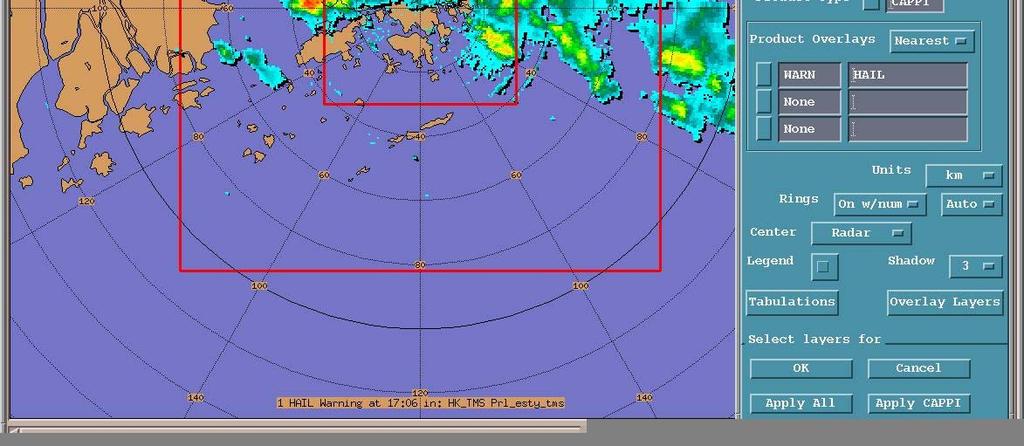
38 Hail Warning product
39 Alert of mesocyclone Azimuthal shear >= 12 m/s; Reflectivity >= 15 dbz; ; and Area of echo satisfying the above criteria >= 0.3 km2. SHEAR_TDR06 applied to 0.6 PPI data of TDWR; SHEAR_TDR60 applied to 6 6 PPI data of TDWR; SHEAR_TMS00 applied to 0 0 PPI data of TMS (Tai Mo Shan radar); and SHEAR_TCR00 applied to 0 0 PPI data of TCR (Tate s Cairn radar).

40

41

42 Possible mesocyclone identified on radar
43 Types of sea breezes at CLK: Type I local sea breeze circulation resulting from winds converging from all directions of the HKIA when the CLK island is heated up. This results in opposite wind directions at the two ends of the runway; Type II winds converging to Lantau Island resulting in north to northwesterly winds on the runways; and Type III larger scale circulation with west to southwesterly winds flowing from CLK to the New Territories.

44 Three types of sea breezes at CLK:
45 Estimating seabreeze onset time at CLK The equation is a extension of the simple circulation model described in the book of Holton. Many of the parameters in the equation have pre-assigned values, except the following which is read in real-time: v0 is the background wind at 05:30am, represented by the average of the u-component u at stations at WGL, TMT, NLS, TMS and R2C T0 is the initial land-sea tempearture difference(at 0530am), which uses air temperature at HKA and sea temperature reading from North Point at 2:00pm the day d before P0 is the pressure at the circulation base, using pressure at HKA P1 is the pressure at the circulation top, using pressure at NLS
46 Limitation of equation: only applies to seabreeze days at CLK, its estimation is irrelevant when seabreeze is not occuring. may not have a solution when background easterly wind is too strong for seabreeze to reach the shore, when temperature on land is too low(like after a strong cold surge), when the initial prevailing wind is already westerlies
47 Example of sea breeze onset time calculation: Seabreeze onset time estimated for (YYYYMMDD). Background wind is already westerly, seabreeze onset time can't be determined The calculation of seabreeze onset time is based on the following raw input at 05:30 HKT: Wind Stn: WGL, Direction: 190 degree, Force: 3.4 m/s Stn: R2C, Direction: 263 degree, Force: 2.0 m/s Stn: TMS, Direction: 220 degree, Force: 7.3 m/s Stn: TMT, Direction: 133 degree, Force: 3.3 m/s Stn: NLS, Direction: 264 degree, Force: 6.6 m/s Pressure Stn: HKA hpa Stn: NLS 3277 hpa Temperature HK Airport: 28.9 degrees Sea temperature at North Point: 28.0 degrees (Note: reading taken n at 14:00H yesterday)
48 Sea breeze index Bernoulli s s equation ρ 1 U 2 ρ 2 U 2 P = P gh ( 2gh + U 2 ) = T overland T overwater T overland - T overwater U 2 = 2gh( ) SBI = ±(U 2 /ΔT) T overwater
49 Expected parameters Land-sea temperature difference Wind strength Cloudiness Stability

50 Scatter plot of U 2 with Land-sea temperature difference
51 Method Cloudiness 6 >= 6 oktas and meanrh ( hpa) ) >=80% No sea breeze SBI > 7 or SBI < 0 where SBI = U 2 6 (CLK Max Temp SST 6 )


52 Strong wind probability due to tropical cyclone

53 Percentage probability for typhoon

54 TIPS create overlay

55 Cut point to show the time of entering different overlay
 ) in CLK Uncertainties derived from spread of model forecast TC positions with respect to model ensemble forecast or position errors collected from past")
56 Probability Forecast of Strong / Gale Winds /Croswind at CLK Airport HKO s Shipping Warning track Isopleths of probability of occurrence of strong/gale force winds ( kidneys( kidneys ) ) in CLK Uncertainties derived from spread of model forecast TC positions with respect to model ensemble forecast or position errors collected from past statistics
57 Basic Principles HKO s s Shipping Warning track Isopleths of probability of occurrence of strong/gale force winds (a.k.a. kidneys )) in CLK Uncertainties derived from spread of model forecast TC positions with respect to model ensemble forecast or position errors collected from past statistics
58 Basic Principles Probabilities can be calculated based on: Statistical scheme - Forecast position errors of shipping warning tracks during taken as the uncertainties in forecast positions. Model Spread scheme - spread of individual model forecast position from model ensemble taken as the uncertainties in forecast positions.

59 User Interface

60 Forecast probability time series
61 LAPS (Local Analysis and Prediction System) FSL/NOAA univariate analyses (u, v, ω,, T, q, h, S/F, ) + variational dynamic balancing scheme (u, v, ω, h) variational moisture analysis comprehensive cloud analysis diabatic initialization capability for NHM Efficient (~ 5 mins) laps.fsl.noaa.gov/
62 Implementation of LAPS in HKO LAPS Resolution Forecast period 1, 5, 10 km Hourly (analysis only) Data ingested synops, HK and GD AWS, wind profiler, AMDAR, GMS5, QuikSCAT, Radar data ingested reflectivity and Doppler wind + TREC wind Computer platform IBM SP
63 Local Analysis and Prediction System Model lga background synops HK/GD AWS Kalman filter QC surface Surface wind, pp, temp, RH, etc WP/RASS wind 3D wind radiosonde temp 3D temp GPS Radar dbz Doppler wind cloud moisture Cloud cover, 3D RH, cloud ω GMS5/GOES9 q l, q i, q s, q r, q h Satellite sounding balance Balanced 3D u,v,ω, φ TREC wind AMDAR/PIREP lapsprep Initial data for WRF MM5 RAMS Model initialization

 10")

64 TC-LAPS wind speed analysis of Typhoon Imbudo (10, 5, 1 km) 10 km 925hPa 5 km 925hPa 18UTC 23/07/ km surface
65 TC-LAPS Nowcasting First guess Observations Analysis Nowcast ORSM Observations + LAPS + LE SWIRLS Wind, pressure forecasts ORSM = Operational Regional Spectral Model (JMA) LAPS = Local Analysis and Prediction System (FSL, NOAA) SWIRLS = Short-range Warning of Intense Rainstorm in Localized Systems (HKO) LE = Linear Extrapolation (along any TC track)


66 Tropical cyclone nowcast product

67


68

69
70 Thank You, and Any question?
A HIGH-RESOLUTION RAPIDLY-UPDATED METEOROLOGICAL DATA ANALYSIS SYSTEM FOR AVIATION APPLICATIONS
 A HIGH-RESOLUTION RAPIDLY-UPDATED METEOROLOGICAL DATA ANALYSIS SYSTEM FOR AVIATION APPLICATIONS C. S. Lau *, J. T. K. Wan and M. C. Chu Department of Physics, The Chinese University of Hong Kong, Hong
2014 海峽兩岸暨香港地區航空氣象技術講座
 2014 海峽兩岸暨香港地區航空氣象技術講座 P W Li Vice chair Hong Kong Meteorological Society Senior Scientific Officer, Hong Kong Observatory pwli@hko.gov.hk www.meteorology.org.hk GUANGZHOU FIR HK FIR TAIPEI FIR About 276,000
Application of NWP products and meteorological information processing system in Hong Kong
 Application of NWP products and meteorological information processing system in Hong Kong Y.S. Li Scientific Officer Hong Kong Observatory (ysli@hko.gov.hk) 7 million people Hong Kong ~1,100 km sq. Regional
AVIATION APPLICATIONS OF A NEW GENERATION OF MESOSCALE NUMERICAL WEATHER PREDICTION SYSTEM OF THE HONG KONG OBSERVATORY
 P452 AVIATION APPLICATIONS OF A NEW GENERATION OF MESOSCALE NUMERICAL WEATHER PREDICTION SYSTEM OF THE HONG KONG OBSERVATORY Wai-Kin WONG *1, P.W. Chan 1 and Ivan C.K. Ng 2 1 Hong Kong Observatory, Hong
A tail strike event of an aircraft due to terrain-induced wind shear at the Hong Kong International Airport
 METEOROLOGICAL APPLICATIONS Meteorol. Appl. 21: 504 511 (2014) Published online 14 March 2012 in Wiley Online Library (wileyonlinelibrary.com) DOI: 10.1002/met.1303 A tail strike event of an aircraft due
Checklist Templates for Direct Observation and Oral Assessments (AMOB)
") Checklist Templates for Direct Observation and Oral Assessments (AMOB) Competency Assessment System Hong Kong Observatory Hong Kong, China Prepared By: Signed Approved By: Signed Date: 20/08/2012 Date:
Checklist Templates for Direct Observation and Oral Assessments (AMOB) Competency Assessment System Hong Kong Observatory Hong Kong, China Prepared By: Signed Approved By: Signed Date: 20/08/2012 Date:
COMPARISON OF DOPPLER LIDAR OBSERVATIONS OF SEVERE TURBULENCE AND AIRCRAFT DATA. S.T. Chan * and C.W. Mok Hong Kong Observatory, Hong Kong
 4.6 COMPARISON OF DOPPLER LIDAR OBSERVATIONS OF SEVERE TURBULENCE AND AIRCRAFT DATA S.T. Chan * and C.W. Mok Hong Kong Observatory, Hong Kong 1. INTRODUCTION The Hong Kong International Airport (HKIA)
The 5th Meeting of the Coordinating Group of the RA II WIGOS Satellite Project
 The 5th Meeting of the Coordinating Group of the RA II WIGOS Satellite Project 21 October, Vladivostok city, Russky Island, Russia Far Eastern Federal University Hong Kong, China Mr. C.K.So, Scientific
Remote Sensing of Windshear under Tropical Cyclone Conditions in Hong Kong
 Remote Sensing of Windshear under Tropical Cyclone Conditions in Hong Kong Dr H K Lam Director of the Hong Kong Observatory Permanent Representative of Hong Kong, China with WMO Vice-President of WMO Regional
7.17 RAPIDS A NEW RAINSTORM NOWCASTING SYSTEM IN HONG KONG
 7.17 RAPIDS A NEW RAINSTORM NOWCASTING SYSTEM IN HONG KONG Li Ping-Wah *, Wong Wai-Kin and Edwin S.T. Lai Hong Kong Observatory, 134A Nathan Road, Kowloon, Hong Kong 1. INTRODUCTION and the numerical forecast
Reprint 797. Development of a Thunderstorm. P.W. Li
 Reprint 797 Development of a Thunderstorm Nowcasting System in Support of Air Traffic Management P.W. Li AMS Aviation, Range, Aerospace Meteorology Special Symposium on Weather-Air Traffic Management Integration,
Information Note on the Webpage for Significant Convection Monitoring and Forecast
 Information Note on the Webpage for Significant Convection Monitoring and Forecast The webpage displays both the real-time products for monitoring of significant convection and forecast products for significant
Near Real-time Analysis of the Wind Structure of Tropical Cyclones
 Near Real-time Analysis of the Wind Structure of Tropical Cyclones Nathaniel T. Servando Philippine Atmospheric, Geophysical and Astronomical Services Administration (PAGASA) Quezon City, Philippines Ping-wah
AN EMPIRICAL MODEL FOR AERODROME WIND FORECASTING DURING THE PASSAGE OF TROPICAL CYCLONES
 P1.1 AN EMPIRICAL MODEL FOR AERODROME WIND FORECASTING DURING THE PASSAGE OF TROPICAL CYCLONES T. C. Cheung The Chinese University of Hong Kong Hong Kong China P. Cheung C. C. Lam * Hong Kong Observatory
Use of NWP and EPS Products in support of Location-specific Forecasts
 First International Workshop on Prevention and Migration of Meteorological Disasters in Southeast Asia Use of NWP and EPS Products in support of Location-specific Forecasts Edwin S.T. Lai Hong Kong Observatory
Reprint 850. Within the Eye of Typhoon Nuri in Hong Kong in C.P. Wong & P.W. Chan
 Reprint 850 Remote Sensing Observations of the Subsidence Zone Within the Eye of Typhoon Nuri in Hong Kong in 2008 C.P. Wong & P.W. Chan 8 th International Symposium on Tropospheric Profiling: Integration
W.H. Leung, W.M. Ma and H.K. Yeung Hong Kong Observatory, Hong Kong, China
 322 THE APPLICATION OF LIGHTNING DENSITY MAP IN THE ANALYSIS OF A SEVERE RAINSTORM CASE IN HONG KONG W.H. Leung, W.M. Ma and H.K. Yeung Hong Kong Observatory, Hong Kong, China 1. INTRODUCTION On 22 July
Data Short description Parameters to be used for analysis SYNOP. Surface observations by ships, oil rigs and moored buoys
 3.2 Observational Data 3.2.1 Data used in the analysis Data Short description Parameters to be used for analysis SYNOP Surface observations at fixed stations over land P,, T, Rh SHIP BUOY TEMP PILOT Aircraft
Merging Nowcasting and NWP in Weather Warning Operations, with Special Reference to Landslides. C C Lam Hong Kong Observatory Hong Kong, China
 Merging Nowcasting and NWP in Weather Warning Operations, with Special Reference to Landslides C C Lam Hong Kong Observatory Hong Kong, China 1. Introduction In support of weather forecast and warning
NOWCASTING SYSTEMS AND SERVICES IN HONG KONG
 NOWCASTING SYSTEMS AND SERVICES IN HONG KONG Ping-Wah Peter LI Hong Kong Observatory, Aviation Weather Services Branch - Radar and Satellite Meteorology Division 3rd WMO/WWRP International Symposium on
Mechanical Turbulence Wind forms eddies as it blows around hanger, stands of trees or other obstructions
 Turbulence Low-level Turbulence below 15,000 feet consists of Mechanical Turbulence Convective Turbulence Frontal Turbulence Wake Turbulence Mechanical Turbulence Wind forms eddies as it blows around hanger,
OBJECTIVE CALIBRATED WIND SPEED AND CROSSWIND PROBABILISTIC FORECASTS FOR THE HONG KONG INTERNATIONAL AIRPORT
 P 333 OBJECTIVE CALIBRATED WIND SPEED AND CROSSWIND PROBABILISTIC FORECASTS FOR THE HONG KONG INTERNATIONAL AIRPORT P. Cheung, C. C. Lam* Hong Kong Observatory, Hong Kong, China 1. INTRODUCTION Wind is
The first tropospheric wind profiler observations of a severe typhoon over a coastal area in South China
 The first tropospheric wind profiler observations of a severe typhoon over a coastal area in South China Lei Li, 1 Pak Wai Chan, 2 Honglong Yang, 1 Rong Zong, 1 Xia Mao, 1 Yin Jiang 1 and Hongbo Zhuang
Utilising Radar and Satellite Based Nowcasting Tools for Aviation Purposes in South Africa. Erik Becker
 Utilising Radar and Satellite Based Nowcasting Tools for Aviation Purposes in South Africa Erik Becker Morné Gijben, Mary-Jane Bopape, Stephanie Landman South African Weather Service: Nowcasting and Very
Guidance on Aeronautical Meteorological Observer Competency Standards
 Guidance on Aeronautical Meteorological Observer Competency Standards The following guidance is supplementary to the AMP competency Standards endorsed by Cg-16 in Geneva in May 2011. Format of the Descriptions
11/19/14. Chapter 11: Hurricanes. The Atmosphere: An Introduction to Meteorology, 12 th. Lutgens Tarbuck
 Chapter 11: Hurricanes The Atmosphere: An Introduction to Meteorology, 12 th Lutgens Tarbuck Lectures by: Heather Gallacher, Cleveland State University! Hurricanes: " Hurricanes are intense centers of
GPS Meteorology at Japan Meteorological Agency
 GPS Meteorology at Japan Meteorological Agency Masahito Ishihara Japan Meteorological Agency CIMO Expert Team on Remote Sensing Upper-Air Technology and Techniques 14-17 March, 2005 Geneva, Switzerland
Forecast of hurricane track and intensity with advanced IR soundings
 Forecast of hurricane track and intensity with advanced IR soundings Jun Li @, Hui Liu #, Jinlong Li @, and Tim Schmit & @CIMSS/SSEC, University of Wisconsin-Madison #National Center for Atmospheric Research
Published by the Hong Kong Observatory, Hong Kong Special Administrative Region Government.
 Windshear and Turbulence in Hong Kong - information for pilots Published by the Hong Kong Observatory, Hong Kong Special Administrative Region Government. 1st edition 2002 2nd edition 2005 Copyright reserved
DATA FUSION NOWCASTING AND NWP
 DATA FUSION NOWCASTING AND NWP Brovelli Pascal 1, Ludovic Auger 2, Olivier Dupont 1, Jean-Marc Moisselin 1, Isabelle Bernard-Bouissières 1, Philippe Cau 1, Adrien Anquez 1 1 Météo-France Forecasting Department
Xinhua Liu National Meteorological Center (NMC) of China Meteorological Administration (CMA)
 of China Meteorological Administration (CMA)") The short-time forecasting and nowcasting technology of severe convective weather for aviation meteorological services in China Xinhua Liu National Meteorological Center (NMC) of China Meteorological Administration
The short-time forecasting and nowcasting technology of severe convective weather for aviation meteorological services in China Xinhua Liu National Meteorological Center (NMC) of China Meteorological Administration
P. W. Chan and K. K. Hon. 1. Introduction
 Advances in Meteorology Volume 16, Article ID 1454513, 9 pages http://dx.doi.org/1.1155/16/1454513 Research Article Observation and Numerical Simulation of Terrain-Induced Windshear at the Hong Kong International
Application of Nowcast Products to Real-time Warning of Hazardous Weather in Hong Kong
 Application of Nowcast Products to Real-time Warning of Hazardous Weather in Hong Kong M.C. Wong, E.S.T. Lai and P.W. Li Hong Kong Observatory, Hong Kong, China 1. INTRODUCTION Severe weather events may
The Use of GPS Radio Occultation Data for Tropical Cyclone Prediction. Bill Kuo and Hui Liu UCAR
 The Use of GPS Radio Occultation Data for Tropical Cyclone Prediction Bill Kuo and Hui Liu UCAR Current capability of the National Hurricane Center Good track forecast improvements. Errors cut in half
The Impacts of GPS Radio Occultation Data on the Analysis and Prediction of Tropical Cyclones. Bill Kuo, Xingqin Fang, and Hui Liu UCAR COSMIC
 The Impacts of GPS Radio Occultation Data on the Analysis and Prediction of Tropical Cyclones Bill Kuo, Xingqin Fang, and Hui Liu UCAR COSMIC GPS Radio Occultation α GPS RO observations advantages for
Use of radar to detect weather
 2 April 2007 Welcome to the RAP Advisory Panel Meeting Use of radar to detect weather G. Brant Foote Brant Director Foote Rita Roberts Roelof Bruintjes Research Applications Program Radar principles Radio
Chapter 21. Weather Patterns and Severe Storms
 Chapter 21 Weather Patterns and Severe Storms 20.1 Air Masses Air Masses and Weather Air Masses An air mass is an immense body of air that is characterized by similar temperatures and amounts of moisture
Strategic Radar Enhancement Project (SREP) Forecast Demonstration Project (FDP) The future is here and now
 Forecast Demonstration Project (FDP) The future is here and now") Strategic Radar Enhancement Project (SREP) Forecast Demonstration Project (FDP) The future is here and now Michael Berechree National Manager Aviation Weather Services Australian Bureau of Meteorology
Strategic Radar Enhancement Project (SREP) Forecast Demonstration Project (FDP) The future is here and now Michael Berechree National Manager Aviation Weather Services Australian Bureau of Meteorology
Chapter 12: Meteorology
 Chapter 12: Meteorology Section 1: The Causes of Weather 1. Compare and contrast weather and climate. 2. Analyze how imbalances in the heating of Earth s surface create weather. 3. Describe how and where
Application of Radio Occultation Data in Analyses and Forecasts of Tropical Cyclones Using an Ensemble Assimilation System
 Application of Radio Occultation Data in Analyses and Forecasts of Tropical Cyclones Using an Assimilation System Hui Liu, Jeff Anderson, and Bill Kuo NCAR Acknowledgment: C. Snyder, Y. Chen, T. Hoar,
MET Lecture 34 Downbursts
 MET 4300 Lecture 34 Downbursts Downbursts A strong downdraft that originates within the lower part of a cumulus cloud or thunderstorms and spreads out at the surface Downbursts do not require strong thunderstorms
Weather Patterns and Severe Storms
 Weather Patterns and Severe Storms 20.1 Air Masses Air Masses and Weather Air Masses An air mass is an immense body of air that is characterized by similar temperatures and amounts of moisture at any given
Deutscher Wetterdienst
 WakeNet3-Greenwake Workshop Wake Vortex & Wind Monitoring Sensors in all weather conditions DWD s new Remote Wind Sensing Equipment for an Integrated Terminal Weather System (ITWS) Frank Lehrnickel Project
J1.2 Short-term wind forecasting at the Hong Kong International Airport by applying chaotic oscillatory-based neural network to LIDAR data
 J1.2 Short-term wind forecasting at the Hong Kong International Airport by applying chaotic oscillatory-based neural network to LIDAR data K.M. Kwong Hong Kong Polytechnic University, Hong Kong, China
SUMMARY. information from
 INTERNATIONAL CIVIL AVIATION ORGANIZATION WORLD METEOROLOGICAL ORGANIZATION MET/14-IP/ /16 2/6/14 English only Meteorology (MET) Divisional Meeting (2014) Commission for Aeronautical Meteorology Fifteenth
Hong Kong Collection
 (Disclaimer The Government of the Hong Kong Special Administrative Region (including its servants and agents) and the International Federation of Air Line Pilots' Associations make no warranty, statement
An overview of Wet Season Forecasting in the Northern Territory
 TWP-ICE Meeting November 2004 An overview of Wet Season Forecasting in the Northern Territory Lori Chappel Northern Territory Regional Forecasting Centre Australian Government Bureau of Meteorology Day
CHARACTERISATION OF STORM SEVERITY BY USE OF SELECTED CONVECTIVE CELL PARAMETERS DERIVED FROM SATELLITE DATA
 CHARACTERISATION OF STORM SEVERITY BY USE OF SELECTED CONVECTIVE CELL PARAMETERS DERIVED FROM SATELLITE DATA Piotr Struzik Institute of Meteorology and Water Management, Satellite Remote Sensing Centre
Test Form: A Key Final Exam: Spring 2011
 Test Form: A Key Final Exam: Spring 2011 Instructions: Write your name (last name and first name) on your bubble sheet. Write your student identification number on the bubble sheet, and carefully and completely
P1.17 Super-high-resolution Numerical Simulation of Atmospheric Turbulence in an Area of Complex Terrain
 P1.17 Super-high-resolution Numerical Simulation of Atmospheric Turbulence in an Area of Complex Terrain P.W. Chan * Hong Kong Observatory, Hong Kong, China 1. INTRODUCTION Turbulent airflow occurs at
Smart use of Geographic Information System (GIS) platform for delivering weather information and nowcasting services
 platform for delivering weather information and nowcasting services") Smart use of Geographic Information System (GIS) platform for delivering weather information and nowcasting services C. K. Pan Hong Kong Observatory Hong Kong, China It is a world of beauty Source: Image
Smart use of Geographic Information System (GIS) platform for delivering weather information and nowcasting services C. K. Pan Hong Kong Observatory Hong Kong, China It is a world of beauty Source: Image
Wind data collected by a fixed-wing aircraft in the vicinity of a typhoon over the south China coastal waters
 Wind data collected by a fixed-wing aircraft in the vicinity of a typhoon over the south China coastal waters P.W. Chan * and K.K. Hon Hong Kong Observatory, Hong Kong, China Abstract: The fixed-wing aircraft
Plan for operational nowcasting system implementation in Pulkovo airport (St. Petersburg, Russia)
") Plan for operational nowcasting system implementation in Pulkovo airport (St. Petersburg, Russia) Pulkovo airport (St. Petersburg, Russia) is one of the biggest airports in the Russian Federation (150
Plan for operational nowcasting system implementation in Pulkovo airport (St. Petersburg, Russia) Pulkovo airport (St. Petersburg, Russia) is one of the biggest airports in the Russian Federation (150
Aviation Hazards: Thunderstorms and Deep Convection
 Aviation Hazards: Thunderstorms and Deep Convection TREND Diagnosis of thunderstorm hazards using imagery Contents Satellite imagery Visible, infrared, water vapour Basic cloud identification Identifying
Unit 5 Part 2 Test PPT
 Unit 5 Part 2 Test PPT Standard 1: Air Masses Air Mass An air mass is an immense body of air that is characterized by similar temperatures and amounts of moisture at any given altitude When an air mass
 Identification of Predictors for Nowcasting Heavy Rainfall In Taiwan --------------------- Part II: Storm Characteristics and Nowcasting Applications Challenges in Developing Nowcasting Applications for
8.7 Calculation of windshear hazard factor based on Doppler LIDAR data. P.W. Chan * Hong Kong Observatory, Hong Kong, China
 8.7 Calculation of windshear hazard factor based on Doppler LIDAR data P.W. Chan * Hong Kong Observatory, Hong Kong, China Paul Robinson, Jason Prince Aerotech Research 1. INTRODUCTION In the alerting
JOINT WMO TECHNICAL PROGRESS REPORT ON THE GLOBAL DATA PROCESSING AND FORECASTING SYSTEM AND NUMERICAL WEATHER PREDICTION RESEARCH ACTIVITIES FOR 2016
 JOINT WMO TECHNICAL PROGRESS REPORT ON THE GLOBAL DATA PROCESSING AND FORECASTING SYSTEM AND NUMERICAL WEATHER PREDICTION RESEARCH ACTIVITIES FOR 2016 1 Summary of highlights Hong Kong Observatory, Hong
2) What general circulation wind belt is the place of origin for hurricanes? A) westerlies B) trade winds C) doldrums D) horse latitudes
 What general circulation wind belt is the place of origin for hurricanes? A) westerlies B) trade winds C) doldrums D) horse latitudes") Meteo 1010 Homework 6 1) What is the difference between a typhoon and a hurricane? A) A hurricane is a true tropical cyclone, but a typhoon is not. B) A hurricane is stronger than a typhoon. C) They represent
Meteo 1010 Homework 6 1) What is the difference between a typhoon and a hurricane? A) A hurricane is a true tropical cyclone, but a typhoon is not. B) A hurricane is stronger than a typhoon. C) They represent
Final Exam Clicker Questions ATOC 1050 Spring 2011 Chapter 16: Mountain Snowstorms
 Final Exam Clicker Questions ATOC 1050 Spring 2011 Chapter 16: Mountain Snowstorms True or false: Mean annual snowfall in the western United States always increases from south to north. Total precipitation
Probabilistic Quantitative Precipitation Forecasts for Tropical Cyclone Rainfall
 Probabilistic Quantitative Precipitation Forecasts for Tropical Cyclone Rainfall WOO WANG CHUN HONG KONG OBSERVATORY IWTCLP-III, JEJU 10, DEC 2014 Scales of Atmospheric Systems Advection-Based Nowcasting
Impact of different cumulus parameterizations on the numerical simulation of rain over southern China
 Impact of different cumulus parameterizations on the numerical simulation of rain over southern China P.W. Chan * Hong Kong Observatory, Hong Kong, China 1. INTRODUCTION Convective rain occurs over southern
Ch. 3: Weather Patterns
 Ch. 3: Weather Patterns Sect. 1: Air Mass & Fronts Sect. 2: Storms Sect. 3: Predicting the Weather Sect. 4: Weather forecasters use advanced technologies Ch. 3 Weather Fronts and Storms Objective(s) 7.E.1.3
Rainfall at Hilo, Hawaii1. By Tsutomu Takahashi
 February 1977 T. Takahashi 121 Rainfall at Hilo, Hawaii1 By Tsutomu Takahashi Cloud Physics Observatory, Department of Meteorology, University of Hawaii Hilo, Hawaii 96720 (Manuscript received 4 September
Multiscale Analyses of Inland Tropical Cyclone Midlatitude Jet Interactions: Camille (1969) and Danny (1997)
 and Danny (1997)") Multiscale Analyses of Inland Tropical Cyclone Midlatitude Jet Interactions: Camille (1969) and Danny (1997) Matthew Potter, Lance Bosart, and Daniel Keyser Department of Atmospheric and Environmental
Multiscale Analyses of Inland Tropical Cyclone Midlatitude Jet Interactions: Camille (1969) and Danny (1997) Matthew Potter, Lance Bosart, and Daniel Keyser Department of Atmospheric and Environmental
Application of microwave radiometer and wind profiler data in the estimation of wind gust associated with intense convective weather
 Application of microwave radiometer and wind profiler data in the estimation of wind gust associated with intense convective weather P W Chan 1 and K H Wong 2 1 Hong Kong Observatory, 134A Nathan Road,
P4.10. Kenichi Kusunoki 1 * and Wataru Mashiko 1 1. Meteorological Research Institute, Japan
 P4. DOPPLER RADAR INVESTIGATIONS OF THE INNER CORE OF TYPHOON SONGDA (24) Polygonal / elliptical eyewalls, eye contraction, and small-scale spiral bands. Kenichi Kusunoki * and Wataru Mashiko Meteorological
Guided Notes Weather. Part 2: Meteorology Air Masses Fronts Weather Maps Storms Storm Preparation
 Guided Notes Weather Part 2: Meteorology Air Masses Fronts Weather Maps Storms Storm Preparation The map below shows North America and its surrounding bodies of water. Country borders are shown. On the
DEVELOPING AND NON DEVELOPING TROPICAL CYCLONES REVEALED BY HIGH DENSITY CLOUD MOTION WINDS
 DEVELOPING AND NON DEVELOPING TROPICAL CYCLONES REVEALED BY HIGH DENSITY CLOUD MOTION WINDS Xu Jianmin, Fang Xiang, Zhang qisong (National Satellite Meteorological Center) Abstract It has been indicated
Examination of Tropical Cyclogenesis using the High Temporal and Spatial Resolution JRA-25 Dataset
 Examination of Tropical Cyclogenesis using the High Temporal and Spatial Resolution JRA-25 Dataset Masato Sugi Forecast Research Department, Meteorological Research Institute, Japan Correspondence: msugi@mri-jma.go.jp
Tuesday, September 13, 16
 Weather Weather State Objectives 4.c, 4.d, 4.h. Discussion What are some ways in which weather affects your everyday life? Discussion What are some ways in which weather affects your everyday life? What
Isolated severe weather and cold air damming 9 November 2005 By Richard H. Grumm National Weather Service Office State College, PA 16801
 Isolated severe weather and cold air damming 9 November 2005 By Richard H. Grumm National Weather Service Office State College, PA 16801 1. INTRODUCTION Two lines of convection moved over the State of
Weather vs. Climate. Tucson NWS homepage:
 Weather vs. Climate Tucson NWS homepage: www.nws.noaa.gov/twc/ A Weather Forecaster? Betty claims to know exactly when it s going to rain because her knee starts to hurt. Ms. Betty Martin of Newburgh,
Use of lightning data to improve observations for aeronautical activities
 Use of lightning data to improve observations for aeronautical activities Françoise Honoré Jean-Marc Yvagnes Patrick Thomas Météo_France Toulouse France I Introduction Aeronautical activities are very
Chan et al. / J Zhejiang Univ-Sci A (Appl Phys & Eng) (7):
 (7):") Chan et al. / J Zhejiang Univ-Sci A (Appl Phys & Eng) 213 14(7):469-481 469 Journal of Zhejiang University-SCIENCE A (Applied Physics & Engineering) ISSN 1673-565X (Print); ISSN 1862-1775 (Online) www.zju.edu.cn/jzus;
Chan et al. / J Zhejiang Univ-Sci A (Appl Phys & Eng) 213 14(7):469-481 469 Journal of Zhejiang University-SCIENCE A (Applied Physics & Engineering) ISSN 1673-565X (Print); ISSN 1862-1775 (Online) www.zju.edu.cn/jzus;
Mr. P s Science Test!
 WEATHER- 2017 Mr. P s Science Test! # Name Date 1. Draw and label a weather station model. (10 pts) 2. The is the layer of the atmosphere with our weather. 3. Meteorologists classify clouds in about different
Indiana County Flash Flood of 22 June 2017
 Indiana County Flash Flood of 22 June 2017 By Richard H. Grumm National Weather Service State College, PA 1. Overview Slow moving thunderstorms brought 3 to 4 inches of rainfall to Indiana County, PA during
HAZARDOUS WEATHER 1. Dr. Julie Laity Geography 266
 HAZARDOUS WEATHER 1 Dr. Julie Laity Geography 266 Violent Weather Thunderstorms Atmospheric turbulence Lightning and thunder Hail Derechos Tornadoes Tornado measurement and science Tropical Cyclones Hurricanes
and SUMMARY preliminary parameters. 1.1 MET/14-IP/ /15 In line 1.2 WORLD INTERNATIONAL CIVIL AVIATION ORGANIZATION 2/6/14 English only
 INTERNATIONAL CIVIL AVIATION ORGANIZATION Meteorology (MET) Divisional Meeting (2014) WORLD METEOROLOGICAL ORGANIZATION Commission for Aeronautical Meteorology Fifteenth Session MET/14-IP/ /15 2/6/14 English
Understanding Weather and Climate Risk. Matthew Perry Sharing an Uncertain World Conference The Geological Society, 13 July 2017
 Understanding Weather and Climate Risk Matthew Perry Sharing an Uncertain World Conference The Geological Society, 13 July 2017 What is risk in a weather and climate context? Hazard: something with the
Severe Weather with a strong cold front: 2-3 April 2006 By Richard H. Grumm National Weather Service Office State College, PA 16803
 Severe Weather with a strong cold front: 2-3 April 2006 By Richard H. Grumm National Weather Service Office State College, PA 16803 1. INTRODUCTION A strong cold front brought severe weather to much of
Forecasting Local Weather
 Forecasting Local Weather Sea/Land Breeze Temperature Dew Fog Frost Snow Thunderstorms Tropical Cyclones Temperatures: Radiation Balance Typical Diurnal Variation of Temperature Min soon after dawn Temp
Tornadogenesis in Supercells: The Three Main Ingredients. Ted Funk
 Tornadogenesis in Supercells: The Three Main Ingredients Ted Funk NWS Louisville, KY Spring 2002 Environmental Parameters Supercells occur within environments exhibiting several wellknown characteristics
P13A.4 THE AIR FRANCE 358 INCIDENT OF 2 AUGUST 2005 AT TORONTO INTERNATIONAL AIRPORT. Paul Joe
 P13A.4 THE AIR FRANCE 358 INCIDENT OF 2 AUGUST 2005 AT TORONTO INTERNATIONAL AIRPORT Paul Joe Environment Canada, 4905 Dufferin St., Toronto, Ontario, CANADA M3H 5T4 email: paul.joe@ec.gc.ca tel: 416 739
Chapter 24 Tropical Cyclones
 Chapter 24 Tropical Cyclones Tropical Weather Systems Tropical disturbance a cluster of thunderstorms about 250 to 600 km in diameter, originating in the tropics or sub-tropics Tropical depression a cluster
Ch. 11: Hurricanes. Be able to. Define what hurricane is. Identify the life and death of a hurricane. Identify the ways we track hurricanes.
 Ch. 11: Hurricanes Be able to Define what hurricane is. Identify the life and death of a hurricane. Identify the ways we track hurricanes. What are Hurricanes? Smaller than mid-latitude cyclones. Don t
THE MESOSCALE CONVECTIVE SYSTEM FROM
 RISCURI I CATASTROFE, NR.X, VOL.9, NR. 1/2011 THE MESOSCALE CONVECTIVE SYSTEM FROM 24.07.2010 ELZA HAUER, 1 C. NICHITA 1 ABSTRACT. The Mesoscale Convective System from 24.07.2010. A severe weather event
P474 SYDNEY AIRPORT WIND SHEAR ENCOUNTER - 15 APRIL 2007
 P474 SYDNEY AIRPORT WIND SHEAR ENCOUNTER - 15 APRIL 2007 Rodney Potts* 1, Barry Hanstrum 2 and Peter Dunda 2 1. CAWCR, Bureau of Meteorology, Melbourne, VIC, Australia 2. Bureau of Meteorology, Sydney,
WMO Aeronautical Meteorology Scientific Conference 2017
 Session 1 Science underpinning meteorological observations, forecasts, advisories and warnings 1.3 Aerodrome throughput 1.3.1 Wake vortex detection and prediction Frequent-output sub-kilometric NWP models
2016 INTERNATIONAL ATMOSPHERIC RIVERS CONFERENCE SAN DIEGO, CA 8-11 August 2016
 ATMOSPHERIC RIVERS AND ENHANCED INTEGRATED VAPOR TRANSPORT EPISODES: THEIR ROLE IN DAMAGING FRONTAL PASSAGES IN SOUTHERN CALIFORNIA WITH AN EMPHASIS ON STRONG WINDS 2016 INTERNATIONAL ATMOSPHERIC RIVERS
Chapter 3: Weather Fronts & Storms
 Chapter 3: Weather Fronts & Storms An AIR MASS is a large body of air that has similar characteristics (temperature, humidity) throughout. Air masses can be massively large. Air masses are classified by
DOPPLER RADAR AND STORM ENVIRONMENT OBSERVATIONS OF A MARITIME TORNADIC SUPERCELL IN SYDNEY, AUSTRALIA
 155 DOPPLER RADAR AND STORM ENVIRONMENT OBSERVATIONS OF A MARITIME TORNADIC SUPERCELL IN SYDNEY, AUSTRALIA Harald Richter *, Alain Protat Research and Development Branch, Bureau of Meteorology, Melbourne,
Implementation Guidance of Aeronautical Meteorological Observer Competency Standards
 Implementation Guidance of Aeronautical Meteorological Observer Competency Standards The following guidance is supplementary to the AMP competency Standards endorsed by Cg-16 in Geneva in May 2011. Please
Advances in weather and climate science
 Advances in weather and climate science Second ICAO Global Air Navigation Industry Symposium (GANIS/2) 11 to 13 December 2017, Montreal, Canada GREG BROCK Scientific Officer Aeronautical Meteorology Division
CHAPTER 11 THUNDERSTORMS AND TORNADOES MULTIPLE CHOICE QUESTIONS
 CHAPTER 11 THUNDERSTORMS AND TORNADOES MULTIPLE CHOICE QUESTIONS 1. A thunderstorm is considered to be a weather system. a. synoptic-scale b. micro-scale c. meso-scale 2. By convention, the mature stage
Use the terms from the following list to complete the sentences below. Each term may be used only once.
 Skills Worksheet Directed Reading Section: Air Masses Use the terms from the following list to complete the sentences below. Each term may be used only once. high pressure poles low pressure equator wind
Be relevant and effective thinking beyond accuracy and timeliness
 The Fourth Technical Conference on the Management of Meteorological and Hydrological Services in WMO RA II (Asia) Be relevant and effective thinking beyond accuracy and timeliness C. Y. LAM Hong Kong Observatory
Nowcasting techniques in use for severe weather operation in NMC/CMA
 WWRP NMRWG Buenos Aires Aug 2017 Nowcasting techniques in use for severe weather operation in NMC/CMA Jianjie WANG National Meteorological Center, CMA Cascading Weather Forecasting Process --- different
Nowcasting Development and Users Need in Aviation
 Nowcasting Development and Users Need in Aviation Ping-Wah Peter LI Aviation Weather Services Branch, Hong Kong Observatory Working Group in Nowcasting Research Geneva, WMO 8-10 February 2011 Outline The
3 Severe Weather. Critical Thinking
 CHAPTER 2 3 Severe Weather SECTION Understanding Weather BEFORE YOU READ After you read this section, you should be able to answer these questions: What are some types of severe weather? How can you stay