Hong Kong Collection
|
|
|
- Curtis Payne
- 5 years ago
- Views:
Transcription
1
2 (Disclaimer The Government of the Hong Kong Special Administrative Region (including its servants and agents) and the International Federation of Air Line Pilots' Associations make no warranty, statement or representation, express or implied, with respect to the accuracy, availability, completeness or usefulness of the information, contained herein, and in so far as permitted by law, shall not have any legal liability or responsibility (including liability for negligence) for any loss or damage, which may result, whether directly or indirectly, from the supply or use of such information or in reliance thereon. THE UNIVERSITY OF HONG KONG LIBRARIES Hong Kong Collection gift fron Hong Kong (China). Hong Kong Observaroty.
3 r 2 5 NOV 2002 (Foreword, in- The Hong Kong Observatory (HKO) provides windshear and turbulence alerting service for aircraft using the Hong Kong International Airport (HKIA). This booklet aims at providing pilots with the basic information on windshear and turbulence, their causes, and the windshear and turbulence alerting service in Hong Kong. This booklet is provided for reference and education only and is in no way intended to replace individual airline company's Standard Operating Procedures. The booklet has been prepared in cooperation with the International Federation of Air Line Pilots' Associations (IFALPA). Vse ofsym&ocs denotes important notes for pilots denotes examples I denotes information
4 Introduction This booklet is in the form of questions and answers. It starts by explaining what windshear and turbulence are and then explains how the windshear and turbulence alerting service in Hong Kong works. It then goes on to explain what causes windshear and turbulence in and around HKIA, and points out some important points that pilots should understand. Most of you reading this booklet will be experienced aviators and will already be familiar with windshear and turbulence and how they are caused. You may, therefore, wish to treat it as a refresher. For others, this should elucidate what windshear and turbulence are and how they can affect an aircraft. By the end of this booklet, you should understand, among others, the following: 1. 'First Encounter-Maximum Intensity' logic in alerting of windshear events; 2. What the term "Microburst Alert (MBA)" means; 3. The reason why some aircraft encounters windshear while others do not; 4. If windshear and turbulence are expected, what you might experience; and 5. The effects of the local winds nearby the HKIA.
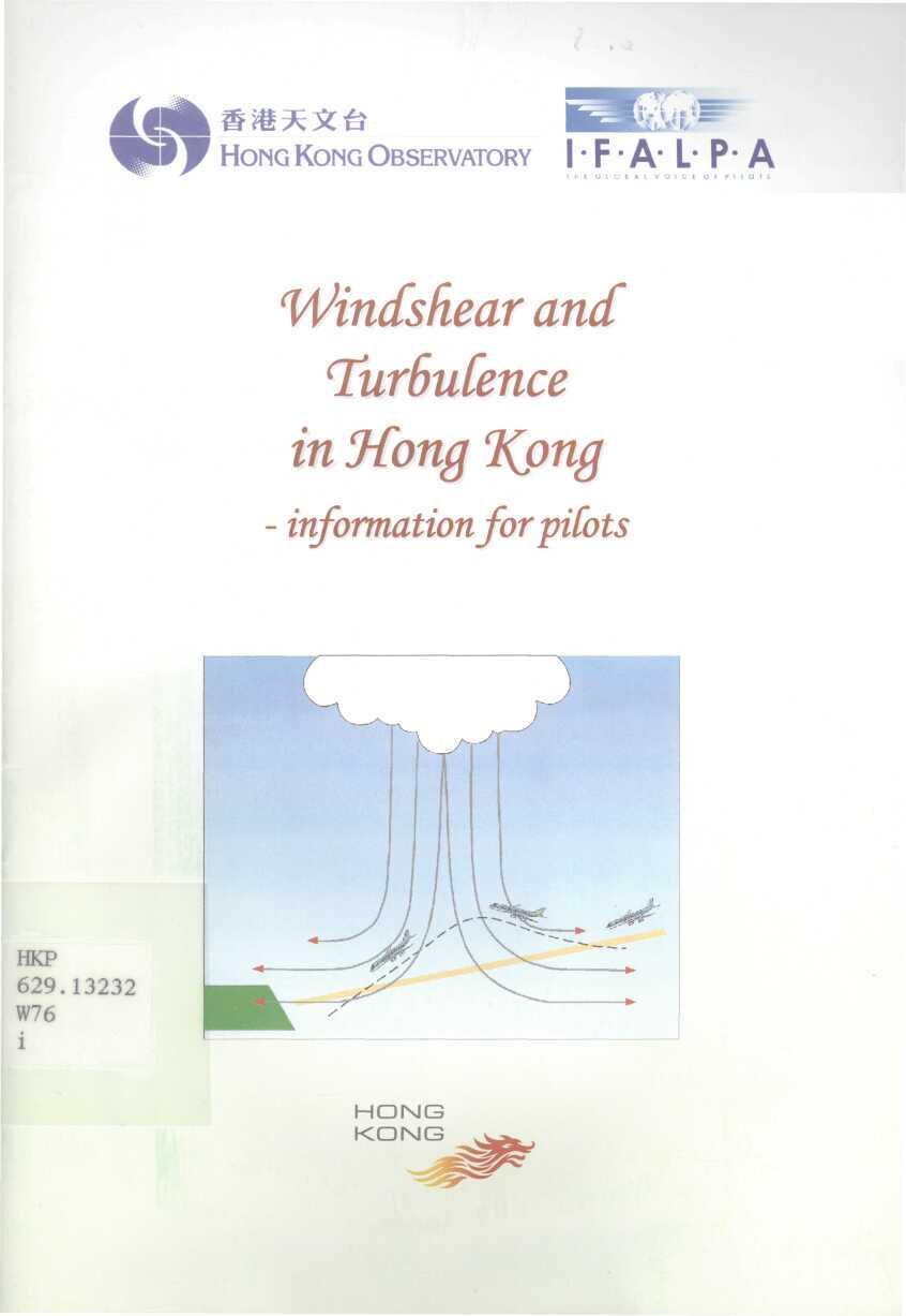
5 What is winds hear and turbulence? Windshear refers to a change in the wind direction and speed for more than a few seconds resulting in a change in the headwind or tailwind encountered by an aircraft. A decreased lift will cause the aircraft to go below the intended flight path (see figure below). Conversely an increased lift will cause the aircraft to fly above the intended flight path. Pilots should be aware that significant windshear at low levels on approach and departure zones may cause difficulty in control requiring timely and appropriate corrective actions to ensure aircraft safety. Intended path Headwind decreases Reduced lift Turbulence is caused by rapid irregular motion of air. It brings about rapid bumps or jolts but does not normally influence the intended flight path of an aircraft significantly. However, in severe turbulence cases, abrupt changes in the altitude and attitude of the aircraft may occur and the pilot may suffer a momentary loss of control.
6 Turbulence Windshear and turbulence events can be very small scale, sporadic and transient in nature and may affect successive aircraft differently. Therefore windshear or turbulence as experienced by an aircraft may at times differ from the conditions reported by preceding aircraft and from the alerts provided. What causes windshear and turbuknce at HKIA? Windshear and turbulence at HKIA can be caused by a wide variety of phenomena including winds blowing across hilly terrain, thunderstorms, gust fronts, tropical cyclones, sea breeze, low-level jet, strong monsoon wind, and cold and warm fronts. Most windshear and turbulence reports at HKIA are caused by strong winds blowing across the hills over Lantau Island to the south of the airport (see map on page 6), including winds associated with the passage of tropical cyclones. This and the other major causes of windshear and turbulence in HKIA are described in more detail later in this booklet.
7 9 ow often are windsfiear and turbuknce experienced at HKIA? For Hong Kong, over the three and a half years since the opening of HKIA (July 1998) to December 2001, about 1 in 700 flights in and out of the airport reported significant windshear. Over the same period, around 1 in 2500 flights reported significant turbulence. A majority of these events were reported in the spring months of March and April. 3fow does HKO afert aircraft to windsfiear and turbufence? HKO operates weather sensors for monitoring of windshear and turbulence conditions in and around HKIA. These include a Terminal Doppler Weather Radar (TDWR), a number of anemometers and 2 wind profilers (see map on page 6). A Windshear and Turbulence Warning System (WTWS), which is equipped with a suite of windshear and turbulence detection algorithms (WTWS algorithms), processes data from these weather sensors. WTWS automatically integrates: (a) windshear alerts generated by TDWR; and (b) windshear and turbulence alerts generated by WTWS algorithms, to form consolidated windshear and turbulence alerts. The information from the weather sensors is also used by the Aviation Forecaster of the HKO to issue alerts to supplement the automatic alerts.

8 Alerts of low-level windshear and turbulence are provided to aircraft in two ways: (a) Windshear and turbulence alerts passed by air traffic controllers (ATC): Alerts of windshear and turbulence induced by terrain or caused by convection within 3 NM of the runway thresholds, which are generated automatically by the WTWS, are passed to aircraft via ATC. (b) Windshear and turbulence alerts broadcast on Automatic Terminal Information System (ATIS): Alerts of windshear and turbulence, which are issued by the Aviation Forecaster, are broadcast to aircraft on ATIS. TalMo i Hong Kong International Airport LANTAU ISLAND
9 What kvek of winds fiearakrts are issued? Based on observations made by the weather sensors, WTWS issues alerts for possible windshear occurring within 3 NM of the runway thresholds: r 3 r 2 r - ~r T - i i 1 ' ( j 1 1 i 1 1 3NM 2NM 1NM 1NM 2NM 3NM RUNWAY r 2 r 3 t 1 MM I Alerts for windshear are classified into two levels: 'Microburst Alert' and 'Windshear Alert'. This follows the same scheme adopted by the US Federal Aviation Administration (FAA) in classifying windshear alerts issued by the TDWR installed at 45 aerodromes in the US. Microburst Alert (MBA): Alerts for windshear with runway-orientated wind speed loss of 30 knots or greater and accompanied by precipitation. This can only be generated by the TDWR. Windshear Alert (WSA): Alerts for windshear with runway-orientated wind speed loss or gain of 15 knots or greater (except microburst). Note that a windshear gain of 30 knots or greater is issued as a WSA, not an MBA.
10 Pilots should bear in mind that 'MBA' is only a terminology to denote an alert generated by TDWR when the runway-orientated wind speed loss is 30 knots or greater and accompanied by precipitation. The windshear associated with an MBA may be caused by phenomena other than a 'conventional' microburst. For instance, strong southerly flow across Lantau Island, coupled with rain, may also trigger an MBA on TDWR. As such, you should not expect the sequence of events in traversing a 'conventional' microburst (i.e. headwind gain and lift preceding a downdraft, followed by headwind loss and sink) to always occur when an MBA is in effect. (What fevek oftursufence akrts are issued? Based on observations made by the weather sensors, WTWS issues alerts for possible turbulence occurring within 3 NM of the runway thresholds. Alerts for turbulence are based on the same intensity thresholds as those adopted for automatic aircraft turbulence reporting by the International Civil Aviation Organization (ICAO). They are issued with reference to heavy category aircraft e.g Turbulence alerts are classified into two levels based on a quantity called eddy dissipation rate (EDR): Alert of Moderate Turbulence: Alerts for turbulence with EDR falling between 0.3 and 0.5, with reference to heavy category aircraft e.g Alert of Severe Turbulence: Alerts for turbulence with EDR of 0.5 or above, with reference to heavy category aircraft e.g
11 Remember that this classification refers to the effect of turbulence on heavy category aircraft. The effect may be more intense on a medium or light category aircraft. is the phraseology of windsdear and turbuknce aterts? The Microburst or Windshear Alert passed by ATC includes the type of alert (i.e. microburst or windshear), the location of first encounter and the maximum value of the computed wind speed difference. See the next question on the principle of 'First Encounter, Maximum Intensity' in alerting windshear. In order to provide concise alerting information for each runway, only a single Microburst Alert or a single Windshear Alert will be passed by ATC irrespective of whether one or more than one occurrence of windshear is detected for that particular runway. Caution. Microburst minus 30 knots 2 mile final. Caution. Windshear plus 15 knots 1 mile on departure. The Turbulence Alert passed by ATC includes the intensity of alert (i.e. moderate or severe turbulence) and the location, i.e. arrival or departure area as appropriate. It should be noted that terrain-induced windshear can be very small scale and may be detected by WTWS as turbulence. When only a Turbulence Alert is given for a particular runway (i.e. no MBA nor WSA is detected for that runway), an alert of significant windshear will also be passed by ATC together with the Turbulence Alert. Caution. Moderate turbulence and significant windshear on departure.
12 When a 'Microburst Alert' or a 'Windshear Alert' is given for a particular runway and turbulence is also detected for that particular runway, a Turbulence Alert' will be passed by ATC together with the 'Microburst Alert' or 'Windshear Alert'. Caution. Windshear minus 20 knots 2 mile final, and moderate turbulence on departure. is "First Encounter-Maximum Intensity"? This is the principle of issuing Microburst or Windshear alerts, the same as that used in the TDWR which is also operated in 45 airports in the US. When more than one occurrence of windshear is detected by the TDWR or by the WTWS algorithms, alerts will be generated by each system based on the highest priority, the maximum intensity, and the location of the first encounter with any occurrence of significant windshear for that runway. The order of priority is such that when both loss and gain events impact the same area, loss events will have higher priority over gain events. It should be noted that the alert refers to the maximum intensity of windshear events within 3 NM from the runway threshold. The alert also indicates the location of the first encounter with an occurrence of windshear, which may not necessarily be of the indicated maximum intensity. So what does this mean to pilots? It means that the location (Runway, 1 NM, 2 NM or 3 NM for either approach or departure) will be where headwind gain or loss of 15 knots or greater is "First Encountered". The "Maximum Intensity" is the maximum loss or gain encountered, anywhere during the 3 NM corridor on approach or departure to the runway. 10
13 An aircraft making an approach to 07 Left encounters a windshear of minus 15 knots at 3 NM, but the maximum intensity is minus 25 knots at one mile final. The alert provided is "Caution. Windshear minus 25 knots (maximum intensity) 3 mile final (first encounter)". The important point to remember is that the maximum windshear may be encountered anywhere from the first alerted location down to the runway (on approach) or to 3 NM (on departure). An aircraft making an approach to 25 Left encounters a windshear of plus 20 knots at 2 NM and a windshear of minus 20 knots at 1 NM. The alert provided is "Caution. Windshear minus 20 knots (maximum intensity) 2 mile final (first encounter)" Cases like the above example can happen, particularly in terrain-induced windshear events (see page 14). Pilots should note that gain and loss events can co-exist on the same arrival or departure corridor. While windshear alert of wind loss is given, you may encounter a wind gain event as well. II
14 is the priority system for MicroBurst jlfert and Both the WTWS algorithm and the TDWR generate alerts of windshear. When a Mircroburst Alert or a Windshear Alert is generated by TDWR and a Windshear Alert is generated by WTWS algorithms for a particular runway, WTWS consolidates the alerts to form an integrated alert based on a priority system given below: 1. (highest) Microburst 2. TDWR windshear of plus 30 knots or greater 3. WTWS windshear of minus 30 knots or greater 4. WTWS windshear of plus 30 knots or greater 5. TDWR windshear of minus knots 6. TDWR windshear of plus knots 7. WTWS windshear of minus knots 8. (lowest) WTWS windshear of plus knots The WTWS automatically issues the alert with a higher priority. If an MBA of minus 30 knots at 1 mile final is generated by TDWR and a WSA of plus 15 knots at Smile final is generated by WTWS algorithms, only the MBA will be issued. 12
15 are the typical scenarios that cause windsfiear and turbuknce in HKIA? There are five typical scenarios that cause windshear and turbulence in Hong Kong. They are listed below in decreasing frequency of occurrence, with the first item being most frequently found in Hong Kong: 1. Winds blowing across terrain (terrain-induced); 2. Gust front (thunderstorm-related); 3. Microburst (thunderstorm-related); 4. Sea breeze; 5. Low level jet. Details of these scenarios are elaborated in the following pages. 13

16 is 'terrain-induced windskear'? Hills disrupt the flow of air across them and hence may induce windshear and turbulence. HKIA is located to the north of the mountainous Lantau Island, the highest peak on which is above 900 m. When winds of 15 knots or higher blow across the hills on Lantau from the east, southeast, south and southwest, windshear and turbulence may occur near the airport. Larger magnitude of windshear and turbulence is possible when the wind speed is over 30 knots. winds from east through southwest across hills on Lantau Island Windshear and turbulence near airport While winds of 20 knots or higher come from the northwest through northeast sectors across the hills to the north of HKIA, windshear and turbulence may also occur near the airport, though much less frequently. 14

17 N Q Winflshear and turbulence ne^f airport winds from northwest through northeast across hillsio north ofhkia On windy occasions such as the approach of a tropical cyclone, air streams of high wind speed may emerge from mountain gaps. Lying between these high-speed air streams are air streams of lower wind speed. Aircraft traversing through alternating high-speed and low-speed air streams may encounter headwind losses and gains at different locations along the approach and departure corridors (refer to second example on page 11). high wind speed ) low wind speed 15
18 In particular, if an aircraft flies from a low-speed air stream to a high-speed air stream, it may experience a large headwind gain leading to a lift of the aircraft. If the aircraft moves from a high-speed air stream to a low-speed air stream, it may experience a large headwind loss resulting in a sinking motion. This sink occurs irrespective of whether there is accompanying precipitation or not. Apart from windy situations, windshear may also occur over the airport in lighter wind conditions when the atmosphere is stable (e.g. presence of a low-level temperature inversion). In fact, windshear has been known to occur when winds of less than 15 knots blow across the hills on Lantau Island in the spring months. Due to the sporadic and transient characteristics of windshear, a wind speed loss/gain may not necessarily be followed/preceded by a wind speed gain/loss. Some aircraft may experience windshear and/or turbulence, while others do not, even though the weather conditions are broadly the same. Windshear and turbulence are on average more significant on the southern runway because of the closeness to the hills of Lantau Island. Terrain-induced windshear does not necessarily occur in rain. As a matter of fact, many of the terrain-induced windshear reports received from aircraft flying into or out of HKIA are not associated with precipitation. While terrain-induced windshear is not caused by a 'conventional microburst' (see page 17), the headwind loss and the sink that it brings to an aircraft may be comparable to that of a 'conventional' microburst. 16

19 What is a 'gust front'? Severe thunderstorms are associated with intense convection, often resulting in violent downdraft and heavy rain. The descending air is cool and dense, and spreads out on hitting the ground. The leading edge of the cool air is called the gust front. Aircraft flying across a gust front may encounter increased headwind and lift. What is a 'microsurst'? Microburst is the most violent form of downdraft from a thunderstorm. It is characterized by an intense and localized descent of cool air, causing a sudden outflow of horizontal winds above the ground with a typical horizontal extent of a few kilometres. An aircraft flying through a microburst may first encounter an increasing headwind and lift, then a downdraft from above the aircraft, followed by an increasing tailwind and sink. To overcome the adverse effect of the microburst, the pilot needs to take timely corrective action to ensure aircraft safety. 17

20 Well, that is the ideal theoretical world, though it can happen like this in practice, as some pilots have experienced. The first point, however, is that microburst can be asymmetric, having winds on one side stronger than the other side. The second point is that the column of downdraft can hit the ground at an angle, rather than vertically downward. So, if you are carrying out an approach through a microburst, you may not encounter the "classic" headwind gain and lift prior to the downdraft and headwind loss. 18

21 What is 'sea Breeze? Sea breeze usually develops under fine weather and light wind conditions. At HKIA, the onset of sea breeze is typically characterized by winds turning westerly over the western part of the airport. With prevailing easterly winds blowing in the background, significant windshear in the form of headwind gain to an aircraft may develop along the runways. While not frequent, windshear of 20 knots or greater associated with sea breeze may occur under background easterly winds of 10 knots or higher. Such a weather set-up occurs more in winter and spring. Apart from windshear, turbulence is also known to occur in a sea breeze. background winds 19

22 s A low-level jet is a narrow band of strong winds in the lower atmosphere. Windshear arising from a low-level jet is relatively infrequent in HKIA. When an aircraft departing from the airport ascends and enters the jet, it experiences increasing headwind and lift. As it departs the jet, however, the headwind and lift decrease. above ground headwind and ^^ lift decrease ^ headwind and lift increase low-level jet stream Headwind By virtue of its flying usually against the prevailing wind, a landing aircraft passing through a jet will also encounter the same sequence of headwind changes. However, since a landing aircraft usually descends on a less gradient (i.e. 3 degrees glide path) than a departing aircraft, the extent of headwind changes it would experience is generally less than that for a departing aircraft. 20
23 Notes to pifots In summary, here are a number of important points to note: Windshear and turbulence events are by nature transient and sporadic. This is especially so when winds change rapidly, for instance during the passage of a tropical cyclone or when winds blow across terrain. Even though the weather conditions may remain broadly similar, some aircraft may experience them while others do not. Windshear associated with an "MBA" may be caused by phenomena other than a microburst in the conventional sense. Pilots should not expect the sequence of event in traversing a 'conventional' microburst (i.e. headwind gain and lift preceding a downdraft, followed by headwind loss and sink) to occur every time the MBA is in effect. Terrain-induced windshear does not necessarily occur in rain. Terrain-induced windshear, coupled with rain, may trigger an "MBA". Microburst can be asymmetric, having winds on one side stronger than the other side. The column of downdraft from a microburst can hit the ground at an angle, rather than vertically downward. So, if you have to carry out an approach through a microburst, you may not encounter the "classic" headwind gain and lift prior to the downdraft and headwind loss. 21
24 Windshear and turbulence alerts are based on 'First Encounter, Maximum Intensity' rule. Remember that the First Encounter may not be the Worst Encounter. Also remember that there may still be windshear/turbulence after the First Encounter. Gain and loss events can co-exist on the same arrival or departure corridor, particularly for terrain-induced windshear. While a windshear alert of wind loss is given, you may encounter a wind gain event as well. Most windshear and turbulence reports at HKIA are caused by strong winds blowing across the hills on Lantau Island to the south of the airport, including winds associated with the passage of tropical cyclones. Windshear and turbulence induced by the hills on Lantau Island are more significant on the southern runway because of the closeness to the hills. Whenever a "MBA" or "WSA" is in effect, particularly for windshear gain or loss of 30 knots or greater, you are advised to avoid entering into the microburst or windshear region. Finally, the HKO really needs your help! If you encounter windshear or turbulence, please report the event to ATC or fax a pilot report to HKO. If you don't encounter it and it is being forecast and/or alerted, the HKO still needs to know, so tell ATC and HKO. Your reports and answers to the surveys have already been used and will continue to be used to enhance the system. Thanks to all of you for the feedback. Keep reporting windshear and turbulence! 22
25 Way forward The existing windshear alerting facilities for the HKIA rely on TDWR, wind profilers and surface anemometers for windshear detection. The TDWR basically makes use of the movement of water droplets suspended in the air to estimate the wind speed. When the weather is fine, there are few water droplets in the air and the TDWR will not be able to detect windshear as effectively as in rainy weather. To supplement the detection of windshear and turbulence under rain-free condition, HKO has installed a Light Detection And Ranging (LIDAR) system at the HKIA. This 'laser radar' tracks movement of particulates in the air and is suitable for weather monitoring under fine weather. Data collection is underway, and this is followed by analysis by the forecaster and development of windshear detection techniques by means of LIDAR. It is expected that the LIDAR will become fully operational by the mid-2000's. In addition, the HKO is continually reviewing the service for further enhancement. This includes improving detection algorithms, enhancement of displays for the air traffic controllers and actively seeking feedback from the users, especially the pilots and air traffic controllers. 23
26 (Further information For more information on the windshear and turbulence alerting service in Hong Kong, please visit HKO's website at: windshear_warning_e.htm You may also refer to section GENS.5 in the Hong Kong Aeronautical Information Publication (AIP) which is available at: More information on windshear, particularly the effect of low-level windshear on aircraft performance, can be found in: ICAO Circular 186-AN/122 "Wind Shear" (1987) US Federal Aviation Administration's No "Pilot Windshear Guide" (1988) Advisory Circular HKO homepage: HKO address: IFALPA homepage: Copyright reserved
27 HKP W76 i Windshear and turbulence in Hong Kong : information for pilots Hong Kong : Printing Dept., C2002. Date Due OT FOR LO
28
Published by the Hong Kong Observatory, Hong Kong Special Administrative Region Government.
 Windshear and Turbulence in Hong Kong - information for pilots Published by the Hong Kong Observatory, Hong Kong Special Administrative Region Government. 1st edition 2002 2nd edition 2005 Copyright reserved
Remote Sensing of Windshear under Tropical Cyclone Conditions in Hong Kong
 Remote Sensing of Windshear under Tropical Cyclone Conditions in Hong Kong Dr H K Lam Director of the Hong Kong Observatory Permanent Representative of Hong Kong, China with WMO Vice-President of WMO Regional
SUMMARY. information from
 INTERNATIONAL CIVIL AVIATION ORGANIZATION WORLD METEOROLOGICAL ORGANIZATION MET/14-IP/ /16 2/6/14 English only Meteorology (MET) Divisional Meeting (2014) Commission for Aeronautical Meteorology Fifteenth
8.7 Calculation of windshear hazard factor based on Doppler LIDAR data. P.W. Chan * Hong Kong Observatory, Hong Kong, China
 8.7 Calculation of windshear hazard factor based on Doppler LIDAR data P.W. Chan * Hong Kong Observatory, Hong Kong, China Paul Robinson, Jason Prince Aerotech Research 1. INTRODUCTION In the alerting
COMPARISON OF DOPPLER LIDAR OBSERVATIONS OF SEVERE TURBULENCE AND AIRCRAFT DATA. S.T. Chan * and C.W. Mok Hong Kong Observatory, Hong Kong
 4.6 COMPARISON OF DOPPLER LIDAR OBSERVATIONS OF SEVERE TURBULENCE AND AIRCRAFT DATA S.T. Chan * and C.W. Mok Hong Kong Observatory, Hong Kong 1. INTRODUCTION The Hong Kong International Airport (HKIA)
P. W. Chan and K. K. Hon. 1. Introduction
 Advances in Meteorology Volume 16, Article ID 1454513, 9 pages http://dx.doi.org/1.1155/16/1454513 Research Article Observation and Numerical Simulation of Terrain-Induced Windshear at the Hong Kong International
A tail strike event of an aircraft due to terrain-induced wind shear at the Hong Kong International Airport
 METEOROLOGICAL APPLICATIONS Meteorol. Appl. 21: 504 511 (2014) Published online 14 March 2012 in Wiley Online Library (wileyonlinelibrary.com) DOI: 10.1002/met.1303 A tail strike event of an aircraft due
Reprint 797. Development of a Thunderstorm. P.W. Li
 Reprint 797 Development of a Thunderstorm Nowcasting System in Support of Air Traffic Management P.W. Li AMS Aviation, Range, Aerospace Meteorology Special Symposium on Weather-Air Traffic Management Integration,
Mechanical Turbulence Wind forms eddies as it blows around hanger, stands of trees or other obstructions
 Turbulence Low-level Turbulence below 15,000 feet consists of Mechanical Turbulence Convective Turbulence Frontal Turbulence Wake Turbulence Mechanical Turbulence Wind forms eddies as it blows around hanger,
MET Lecture 34 Downbursts
 MET 4300 Lecture 34 Downbursts Downbursts A strong downdraft that originates within the lower part of a cumulus cloud or thunderstorms and spreads out at the surface Downbursts do not require strong thunderstorms
J1.2 Short-term wind forecasting at the Hong Kong International Airport by applying chaotic oscillatory-based neural network to LIDAR data
 J1.2 Short-term wind forecasting at the Hong Kong International Airport by applying chaotic oscillatory-based neural network to LIDAR data K.M. Kwong Hong Kong Polytechnic University, Hong Kong, China
WMO Aeronautical Meteorology Scientific Conference 2017
 Session 1 Science underpinning meteorological observations, forecasts, advisories and warnings 1.3 Aerodrome throughput 1.3.1 Wake vortex detection and prediction Frequent-output sub-kilometric NWP models
P474 SYDNEY AIRPORT WIND SHEAR ENCOUNTER - 15 APRIL 2007
 P474 SYDNEY AIRPORT WIND SHEAR ENCOUNTER - 15 APRIL 2007 Rodney Potts* 1, Barry Hanstrum 2 and Peter Dunda 2 1. CAWCR, Bureau of Meteorology, Melbourne, VIC, Australia 2. Bureau of Meteorology, Sydney,
A HIGH-RESOLUTION RAPIDLY-UPDATED METEOROLOGICAL DATA ANALYSIS SYSTEM FOR AVIATION APPLICATIONS
 A HIGH-RESOLUTION RAPIDLY-UPDATED METEOROLOGICAL DATA ANALYSIS SYSTEM FOR AVIATION APPLICATIONS C. S. Lau *, J. T. K. Wan and M. C. Chu Department of Physics, The Chinese University of Hong Kong, Hong
Pilot briefing ENTC - Tromsø airport, Langnes
 Pilot briefing ENTC - Tromsø airport, Langnes NOTE: The content in this briefing will not be updated as frequently as AIP Norway. Make sure you always check relevant information in the latest edition of
Wind data collected by a fixed-wing aircraft in the vicinity of a typhoon over the south China coastal waters
 Wind data collected by a fixed-wing aircraft in the vicinity of a typhoon over the south China coastal waters P.W. Chan * and K.K. Hon Hong Kong Observatory, Hong Kong, China Abstract: The fixed-wing aircraft
Doppler Weather Radars and Weather Decision Support for DP Vessels
 Author s Name Name of the Paper Session DYNAMIC POSITIONING CONFERENCE October 14-15, 2014 RISK SESSION Doppler Weather Radars and By Michael D. Eilts and Mike Arellano Weather Decision Technologies, Inc.
Flight Operations Briefing Notes
 Flight Operations Briefing Notes I Introduction Flight crew awareness and alertness are key factors in the successful application of windshear avoidance and escape / recovery techniques. This Flight Operations
A Path to Shed Light on the Windshear. Enhancing the windshear alerting systems in airports by integrating a LiDAR-based system.
 DTN WHITE PAPER A Path to Shed Light on the Windshear Enhancing the windshear alerting systems in airports by integrating a LiDAR-based system August 2017 www.dtn.com / 1.800.509.8927 2017 DTN, Inc Summary
and SUMMARY preliminary parameters. 1.1 MET/14-IP/ /15 In line 1.2 WORLD INTERNATIONAL CIVIL AVIATION ORGANIZATION 2/6/14 English only
 INTERNATIONAL CIVIL AVIATION ORGANIZATION Meteorology (MET) Divisional Meeting (2014) WORLD METEOROLOGICAL ORGANIZATION Commission for Aeronautical Meteorology Fifteenth Session MET/14-IP/ /15 2/6/14 English
Chan et al. / J Zhejiang Univ-Sci A (Appl Phys & Eng) (7):
 (7):") Chan et al. / J Zhejiang Univ-Sci A (Appl Phys & Eng) 213 14(7):469-481 469 Journal of Zhejiang University-SCIENCE A (Applied Physics & Engineering) ISSN 1673-565X (Print); ISSN 1862-1775 (Online) www.zju.edu.cn/jzus;
Chan et al. / J Zhejiang Univ-Sci A (Appl Phys & Eng) 213 14(7):469-481 469 Journal of Zhejiang University-SCIENCE A (Applied Physics & Engineering) ISSN 1673-565X (Print); ISSN 1862-1775 (Online) www.zju.edu.cn/jzus;
P1.17 Super-high-resolution Numerical Simulation of Atmospheric Turbulence in an Area of Complex Terrain
 P1.17 Super-high-resolution Numerical Simulation of Atmospheric Turbulence in an Area of Complex Terrain P.W. Chan * Hong Kong Observatory, Hong Kong, China 1. INTRODUCTION Turbulent airflow occurs at
Montréal, 7 to 18 July 2014
 INTERNATIONAL CIVIL AVIATION ORGANIZATION WORLD METEOROLOGICAL ORGANIZATION 6/5/14 Meteorology (MET) Divisional Meeting (2014) Commission for Aeronautical Meteorology Fifteenth Session Montréal, 7 to 18
Use of radar to detect weather
 2 April 2007 Welcome to the RAP Advisory Panel Meeting Use of radar to detect weather G. Brant Foote Brant Director Foote Rita Roberts Roelof Bruintjes Research Applications Program Radar principles Radio
Traffic and Weather. Soaring Safety Foundation. Tom Johnson CFIG
 Traffic and Weather Soaring Safety Foundation Tom Johnson CFIG Weather Contents Weather Gathering Sources Weather Acquisition Enroute Weather Analysis Weather Hazards Weather in the Landing Pattern Basic
MetConsole LLWAS (Low Level Wind Shear Alert System)
") MetConsole LLWAS (Low Level Wind Shear Alert System) Enhancing aircraft safety under wind shear conditions Make the most of your energy SM MetConsole Low Level Wind Shear Alert System The Schneider Electric
MetConsole LLWAS (Low Level Wind Shear Alert System) Enhancing aircraft safety under wind shear conditions Make the most of your energy SM MetConsole Low Level Wind Shear Alert System The Schneider Electric
CHAPTER 11 THUNDERSTORMS AND TORNADOES MULTIPLE CHOICE QUESTIONS
 CHAPTER 11 THUNDERSTORMS AND TORNADOES MULTIPLE CHOICE QUESTIONS 1. A thunderstorm is considered to be a weather system. a. synoptic-scale b. micro-scale c. meso-scale 2. By convention, the mature stage
Real-Time defenses. FlightOPS
 Real-Time defenses By Wayne Rosenkrans Integrating data from terminal Doppler weather radar and anemometer-based wind shear alerting systems during the past years has further reduced, but not eliminated,
Information Note on the Webpage for Significant Convection Monitoring and Forecast
 Information Note on the Webpage for Significant Convection Monitoring and Forecast The webpage displays both the real-time products for monitoring of significant convection and forecast products for significant
TOPICS: What are Thunderstorms? Ingredients Stages Types Lightning Downburst and Microburst
 THUNDERSTORMS TOPICS: What are Thunderstorms? Ingredients Stages Types Lightning Downburst and Microburst What are Thunderstorms? A storm produced by a cumulonimbus cloud that contains lightning and thunder
Meteorology. Review Extreme Weather a. cold front. b. warm front. What type of weather is associated with a:
 Meteorology 5.08 Extreme Weather References: FTGU pages 132, 144, 145, 148-155 Air Command Weather Manual Chapters 9 and 15 Review What type of weather is associated with a: a. cold front b. warm front
Go With the Flow From High to Low Investigating Isobars
 Go With the Flow From High to Low Investigating Isobars Science 10 Mrs. Purba Air Masses The air over a warm surface can be heated, causing it to rise above more dense air. The result is the formation
Subject: Clear Air Turbulence Avoidance Date: 3/22/16 AC No: 00-30C Initiated by: AFS-400 Change:
 U.S. Department of Transportation Federal Aviation Administration Advisory Circular Subject: Clear Air Turbulence Avoidance Date: 3/22/16 AC No: 00-30C Initiated by: AFS-400 Change: 1 PURPOSE. This advisory
Section 7: Hazard Avoidance
 7.1 In-Flight Hazard Awareness Section 7: Hazard Avoidance As technology improves, pilots have more and more real-time information within reach in all phases of flight. Terrain proximity, real-time weather
METEOROLOGY PANEL (METP) WORKING GROUP- METEOROLOGICAL OPERATION GROUP (MOG) FIRST MEETING
 WORKING GROUP- METEOROLOGICAL OPERATION GROUP (MOG) FIRST MEETING") 8 28/7/15 METEOROLOGY PANEL (METP) WORKING GROUP- METEOROLOGICAL OPERATION GROUP (MOG) FIRST MEETING Gatwick, United Kingdom, 08 to 11 September 2015 Agenda Item 3: Matters relating to SADIS 3.3: Operations
8 28/7/15 METEOROLOGY PANEL (METP) WORKING GROUP- METEOROLOGICAL OPERATION GROUP (MOG) FIRST MEETING Gatwick, United Kingdom, 08 to 11 September 2015 Agenda Item 3: Matters relating to SADIS 3.3: Operations
Foundations of Earth Science, 6e Lutgens, Tarbuck, & Tasa
 Foundations of Earth Science, 6e Lutgens, Tarbuck, & Tasa Weather Patterns and Severe Weather Foundations, 6e - Chapter 14 Stan Hatfield Southwestern Illinois College Air masses Characteristics Large body
Application of microwave radiometer and wind profiler data in the estimation of wind gust associated with intense convective weather
 Application of microwave radiometer and wind profiler data in the estimation of wind gust associated with intense convective weather P W Chan 1 and K H Wong 2 1 Hong Kong Observatory, 134A Nathan Road,
Weather and Climate 1. Elements of the weather
 Weather and Climate 1 affect = to have an effect on, influence, change altitude = the height of a place above the sea axis = the line around which an object rotates certain = special consist of = to be
METEOROLOGY. 1 The average height of the tropopause at 50 N is about A 14 km B 16 km C 11 km D 8 km
 1 The average height of the tropopause at 50 N is about A 14 km B 16 km C 11 km D 8 km 2 In the lower part of the stratosphere the temperature A is almost constant B decreases with altitude C increases
TAKEOFF CONSIDERATIONS...
 CHAPTER 4 TAKEOFFS TAKEOFF CONSIDERATIONS.................. 2-37 AIRSPEED.................................. 2-37 TAKEOFF POWER............................ 2-38 RUNWAY LENGTH REQUIREMENT.............. 2-39
International Civil Aviation Organization
 CNS/MET SG/14 IP/19 International Civil Aviation Organization FOURTEENTH MEETING OF THE COMMUNICATIONS/NAVIGATION/SURVEILL ANCE AND METEOROLOGY SUB-GROUP OF APANPIRG (CNS/MET SG/14) Jakarta, Indonesia,
M o d u l e k A i r c r a f t A e r o d y n a m i c s, S t r u c t u r e s a n d S y s t e m s
 Category A B1 B2 B3 08 Instrument systems (ATA 31) Level 1 2 3 M o d u l e 1 3-0 8 k A i r c r a f t A e r o d y n a m i c s, S t r u c t u r e s a n d S y s t e m s I n s t r u m e n t S y s t e m s -
WAFS_Word. 2. Menu. 2.1 Untitled Slide
 WAFS_Word 2. Menu 2.1 Untitled Slide Published by Articulate Storyline 1. Introduction 1.1 Introduction Notes: As you will probably be aware, the traditional significant weather forecasts, usually seen
Space Atmospheric Gases. the two most common gases; found throughout all the layers a form of oxygen found in the stratosphere
 Earth s atmospheric layers Earth s atmosphere is the layer of gases that surrounds the planet and makes conditions on Earth suitable for living things. Layers Earth s atmosphere is divided into several
Implementation Guidance of Aeronautical Meteorological Observer Competency Standards
 Implementation Guidance of Aeronautical Meteorological Observer Competency Standards The following guidance is supplementary to the AMP competency Standards endorsed by Cg-16 in Geneva in May 2011. Please
Montréal, 7 to 18 July 2014
 INTERNATIONAL CIVIL AVIATION ORGANIZATION WORLD METEOROLOGICAL ORGANIZATION MET/14-WP/34 28/5/14 Meteorology (MET) Divisional Meeting (2014) Commission for Aeronautical Meteorology Fifteenth Session Montréal,
BMeteorologische Zeitschrift, PrePub DOI /metz/2017/0858
 BMeteorologische Zeitschrift, PrePub DOI 10.1127/metz/2017/0858 2017 The authors Traffic Meteorology Application of spectral decomposition of LIDAR-based headwind profiles in windshear detection at the
The Atmosphere - Chapter Characteristics of the Atmosphere
 Section Objectives Describe the composition of Earth s atmosphere. Explain how two types of barometers work. Identify the layers of the atmosphere. Identify two effects of air pollution. The Atmosphere
AN EMPIRICAL MODEL FOR AERODROME WIND FORECASTING DURING THE PASSAGE OF TROPICAL CYCLONES
 P1.1 AN EMPIRICAL MODEL FOR AERODROME WIND FORECASTING DURING THE PASSAGE OF TROPICAL CYCLONES T. C. Cheung The Chinese University of Hong Kong Hong Kong China P. Cheung C. C. Lam * Hong Kong Observatory
Tuesday, September 13, 16
 Weather Weather State Objectives 4.c, 4.d, 4.h. Discussion What are some ways in which weather affects your everyday life? Discussion What are some ways in which weather affects your everyday life? What
WEATHER THEORY. Weather Theory Page 100 Aviation Seminars. Measurement Of Temperature, Pressure And Moisture. Stability (Cont)
") Weather Theory Page 100 WEATHER THEORY Measurement Of Temperature, Pressure And Moisture The primary cause of all changes in the earth s weather is variation of solar energy received by the Earth s regions..
Weather Theory Page 100 WEATHER THEORY Measurement Of Temperature, Pressure And Moisture The primary cause of all changes in the earth s weather is variation of solar energy received by the Earth s regions..
Flight Dispatcher Aviation Meteorology Required Knowledge
 Flight Dispatcher Aviation Meteorology Required Knowledge 3.1 THE EARTH'S ATMOSPHERE 1 Properties 2 Vertical Structure 3 ICAO Standard Atmosphere 3.2 ATMOSPHERIC PRESSURE 1 Pressure Measurements 2 Station
Chapter 24 Tropical Cyclones
 Chapter 24 Tropical Cyclones Tropical Weather Systems Tropical disturbance a cluster of thunderstorms about 250 to 600 km in diameter, originating in the tropics or sub-tropics Tropical depression a cluster
Ch. 3: Weather Patterns
 Ch. 3: Weather Patterns Sect. 1: Air Mass & Fronts Sect. 2: Storms Sect. 3: Predicting the Weather Sect. 4: Weather forecasters use advanced technologies Ch. 3 Weather Fronts and Storms Objective(s) 7.E.1.3
The Atmosphere. Characteristics of the Atmosphere. Section 23.1 Objectives. Chapter 23. Chapter 23 Modern Earth Science. Section 1
 The Atmosphere Chapter 23 Modern Earth Science Characteristics of the Atmosphere Chapter 23 Section 1 Section 23.1 Objectives Describe the composition of Earth s atmosphere. Explain how two types of barometers
Science Olympiad Meteorology Quiz #2 Page 1 of 8
 1) The prevailing general direction of the jet stream is from west to east in the northern hemisphere: 2) Advection is the vertical movement of an air mass from one location to another: 3) Thunderstorms
Examination #3 Wednesday, 28 November 2001
 Name & Signature Dr. Droegemeier Student ID Meteorology 1004 Introduction to Meteorology Fall, 2001 Examination #3 Wednesday, 28 November 2001 BEFORE YOU BEGIN!! Please be sure to read each question CAREFULLY
Weather and Climate Basics
 Weather and Climate Basics Laura Boekel Forecaster at Bureau of Meteorology Aims of this presentation To describe what I do as a forecaster at the Bureau of Meteorology To provide an interesting introduction
Guidance on Aeronautical Meteorological Observer Competency Standards
 Guidance on Aeronautical Meteorological Observer Competency Standards The following guidance is supplementary to the AMP competency Standards endorsed by Cg-16 in Geneva in May 2011. Format of the Descriptions
QNH: With this setting set on your altimeter you will be reading altitude above mean sea level based on the local station pressure.
 ALTIMETRY How many different altimeter settings confront you when operating internationally? Not only that, how many different ways are there to report an altimeter setting? If not operating internationally
SCOPE: Outlines standard techniques for setting up and conducting voice communication and broadcasting ATIS at Hong Kong VACC
 STANDARD OPERATING PROCEDURE (SOP) DOCUMENT NUMBER: HKVACC-SOP011-R5 DATE ISSUED: 1 APR 2015 REVISION: 5 SUBJECT: Voice Communication Setup and ATIS Guide EFFECTIVE DATE: 5 AUG 2018 SCOPE: Outlines standard
Weather and Climate Basics
 Aims of this presentation Weather and Climate Basics To describe what I do as a forecaster at the Bureau of Meteorology Laura Boekel Forecaster at Bureau of Meteorology To provide an interesting introduction
1 What Is Climate? TAKE A LOOK 2. Explain Why do areas near the equator tend to have high temperatures?
 CHAPTER 17 1 What Is Climate? SECTION Climate BEFORE YOU READ After you read this section, you should be able to answer these questions: What is climate? What factors affect climate? How do climates differ
Global Wind Patterns
 Name: Earth Science: Date: Period: Global Wind Patterns 1. Which factor causes global wind patterns? a. changes in the distance between Earth and the Moon b. unequal heating of Earth s surface by the Sun
Weather Systems. Section
 Section 1 12.2 Objectives Compare and contrast the three major wind systems. Identify four types of fronts. Distinguish between highand low-pressure systems. Review Vocabulary convection: the transfer
2014 海峽兩岸暨香港地區航空氣象技術講座
 2014 海峽兩岸暨香港地區航空氣象技術講座 P W Li Vice chair Hong Kong Meteorological Society Senior Scientific Officer, Hong Kong Observatory pwli@hko.gov.hk www.meteorology.org.hk GUANGZHOU FIR HK FIR TAIPEI FIR About 276,000
AERODROME METEOROLOGICAL OBSERVATION AND FORECAST STUDY GROUP (AMOFSG)
") AMOFSG/9-SN No. 15 21/6/11 AERODROME METEOROLOGICAL OBSERVATION AND FORECAST STUDY GROUP (AMOFSG) NINTH MEETING Montréal, 26 to 30 September 2011 Agenda Item 5: Observing and forecasting at the aerodrome
AMOFSG/9-SN No. 15 21/6/11 AERODROME METEOROLOGICAL OBSERVATION AND FORECAST STUDY GROUP (AMOFSG) NINTH MEETING Montréal, 26 to 30 September 2011 Agenda Item 5: Observing and forecasting at the aerodrome
Science 1206 Chapter 1 - Inquiring about Weather
 Science 1206 Chapter 1 - Inquiring about Weather 1.1 - The Atmosphere: Energy Transfer and Properties (pp. 10-25) Weather and the Atmosphere weather the physical conditions of the atmosphere at a specific
Field study of the latest transmissometers at Hong Kong International Airport
 Field study of the latest transmissometers at Hong Kong International Airport P. W. Chan Hong Kong Observatory 134A Nathan Road, Kowloon, Hong Kong, China Tel:+852 2926 8435, Fax: +852 2311 9448, Email:
The first tropospheric wind profiler observations of a severe typhoon over a coastal area in South China
 The first tropospheric wind profiler observations of a severe typhoon over a coastal area in South China Lei Li, 1 Pak Wai Chan, 2 Honglong Yang, 1 Rong Zong, 1 Xia Mao, 1 Yin Jiang 1 and Hongbo Zhuang
A Description of Convective Weather Containing Ice Crystals Associated with Engine Powerloss and Damage
 A Description of Convective Weather Containing Ice Crystals Associated with Engine Powerloss and Damage The Boeing Company 1 Photo: courtesy of Ian McPherson The Boeing Company acknowledges the contributions
Weather Notes. Chapter 16, 17, & 18
 Weather Notes Chapter 16, 17, & 18 Weather Weather is the condition of the Earth s atmosphere at a particular place and time Weather It is the movement of energy through the atmosphere Energy comes from
Advances in weather and climate science
 Advances in weather and climate science Second ICAO Global Air Navigation Industry Symposium (GANIS/2) 11 to 13 December 2017, Montreal, Canada GREG BROCK Scientific Officer Aeronautical Meteorology Division
Depiction of complex airflow near Hong Kong International Airport using a Doppler LIDAR with a two-dimensional wind retrieval technique
 Meteorologische Zeitschrift, Vol. 16, No. 5, 491-504 (October 2007) (published online 2007) c by Gebrüder Borntraeger 2007 Article Depiction of complex airflow near Hong Kong International Airport using
Module 11: Meteorology Topic 6 Content: Severe Weather Notes
 Severe weather can pose a risk to you and your property. Meteorologists monitor extreme weather to inform the public about dangerous atmospheric conditions. Thunderstorms, hurricanes, and tornadoes are
Deutscher Wetterdienst
 WakeNet3-Greenwake Workshop Wake Vortex & Wind Monitoring Sensors in all weather conditions DWD s new Remote Wind Sensing Equipment for an Integrated Terminal Weather System (ITWS) Frank Lehrnickel Project
Weather is the of the Earth s atmosphere at a place and time. It is the movement of through the atmosphere o Energy comes from the
 Weather Notes Weather Weather is the of the Earth s atmosphere at a place and time It is the movement of through the atmosphere o Energy comes from the The sun is the force that weather The sun s energy
ADL110B ADL120 ADL130 ADL140 How to use radar and strike images. Version
 ADL110B ADL120 ADL130 ADL140 How to use radar and strike images Version 1.00 22.08.2016 How to use radar and strike images 1 / 12 Revision 1.00-22.08.2016 WARNING: Like any information of the ADL in flight
SCOPE: Outlines standard techniques for setting up and conducting voice communication and broadcasting ATIS at Hong Kong VACC
 STANDARD OPERATING PROCEDURE (SOP) DOCUMENT NUMBER: HKVACC-SOP011-R5 DATE ISSUED: 1 APR 2015 REVISION: 5 SUBJECT: Voice Communication Setup and ATIS Guide EFFECTIVE DATE: 5 AUG 2018 SCOPE: Outlines standard
Lecture Outlines PowerPoint. Chapter 19 Earth Science 11e Tarbuck/Lutgens
 Lecture Outlines PowerPoint Chapter 19 Earth Science 11e Tarbuck/Lutgens 2006 Pearson Prentice Hall This work is protected by United States copyright laws and is provided solely for the use of instructors
Reprint 850. Within the Eye of Typhoon Nuri in Hong Kong in C.P. Wong & P.W. Chan
 Reprint 850 Remote Sensing Observations of the Subsidence Zone Within the Eye of Typhoon Nuri in Hong Kong in 2008 C.P. Wong & P.W. Chan 8 th International Symposium on Tropospheric Profiling: Integration
Earth Science, 11e. Weather Patterns and Severe Storms Chapter 19. Air masses. A cold Canadian air mass Figure Air masses. Air masses 9/5/2012
 2006 Pearson Prentice Hall Lecture Outlines PowerPoint Chapter 19 Earth Science 11e Tarbuck/Lutgens This work is protected by United States copyright laws and is provided solely for the use of instructors
Section 13-1: Thunderstorms
 Section 13-1: Thunderstorms Chapter 13 Main Idea: The intensity and duration of thunderstorms depend on the local conditions that create them. Air-mass thunderstorm Mountain thunderstorm Sea-breeze thunderstorm
ATS 351, Spring 2010 Lab #11 Severe Weather 54 points
 ATS 351, Spring 2010 Lab #11 Severe Weather 54 points Question 1 (10 points): Thunderstorm development a) Sketch and describe the stages of development of a single cell thunderstorm. About how long does
HAZARDOUS WEATHER 1. Dr. Julie Laity Geography 266
 HAZARDOUS WEATHER 1 Dr. Julie Laity Geography 266 Violent Weather Thunderstorms Atmospheric turbulence Lightning and thunder Hail Derechos Tornadoes Tornado measurement and science Tropical Cyclones Hurricanes
Air Masses, Fronts, Storm Systems, and the Jet Stream
 Air Masses, Fronts, Storm Systems, and the Jet Stream Air Masses When a large bubble of air remains over a specific area of Earth long enough to take on the temperature and humidity characteristics of
What a Hurricane Needs to Develop
 Weather Weather is the current atmospheric conditions, such as air temperature, wind speed, wind direction, cloud cover, precipitation, relative humidity, air pressure, etc. 8.10B: global patterns of atmospheric
UNITED KINGDOM AERONAUTICAL INFORMATION CIRCULAR
 N UNITED KINGDOM AERONAUTICAL INFORMATION CIRCULAR AIC 84/2008 (Pink 150) 11 September Safety NATS Ltd UK Aeronautical Information Service Heathrow House Bath Road Hounslow Middlesex TW5 9AT Editorial:
Ch. 3: Weather Patterns. Sect. 1: Air Mass & Fronts Sect. 2: Storms Sect. 3: Predicting the Weather
 Ch. 3: Weather Patterns Sect. 1: Air Mass & Fronts Sect. 2: Storms Sect. 3: Predicting the Weather Sect. 1: Air Masses & Fronts An air mass is a huge body of air that has similar temperature, humidity,
1 What Is Climate? TAKE A LOOK 2. Explain Why do areas near the equator tend to have high temperatures?
 CHAPTER 17 1 What Is Climate? SECTION Climate BEFORE YOU READ After you read this section, you should be able to answer these questions: What is climate? What factors affect climate? How do climates differ
Accident Prevention Program
 Thunderstorm Accident Prevention Program Thunderstorms - Don't Flirt...Skirt'Em Pilot's Beware! Within the route you intend to fly may lie a summer hazard in wait for the unwary--the Thunderstorm. The
AOPA. Mitigating Turbulence Impacts in Aviation Operations. General Aviation Perspective
 AOPA Mitigating Turbulence Impacts in Aviation Operations General Aviation Perspective Rune Duke Senior Director, Airspace & Air Traffic Services Aircraft Owners & Pilots Association AOPA Air Safety Institute
CAS & CAeM Aviation Research and Demonstration Project Paris-CDG airport
 World Meteorological Organization Working together in weather, climate and water WMO CAS & CAeM Aviation Research and Demonstration Project Paris-CDG airport WMO www.wmo.int Paris-CDG airport Mid-latitude
Airport Meteorology Analysis
 Airport Meteorology Analysis Alex Alshtein Kurt Etterer October 2014 Presented at ICAO Business Class 2014 ICAO, Montreal, Canada Approved for Public Release: 14-3466. Distribution Unlimited. October 2014
Energy Transfer in the Atmosphere
 Energy Transfer in the Atmosphere Textbook pages 436 459 Section 10.2 Summary Before You Read What do you think causes wind? Write your thoughts in the lines below. Mark the Text In Your Own Words Highlight
777 GROUNDSCHOOL Temperature, Stability, Fronts, & Thunderstorms
 777 GROUNDSCHOOL 2018 Temperature, Stability, Fronts, & Thunderstorms The Atmosphere Heating Transfer of heat occurs thru Radiation Advection Convection Matter changes states due to the amount of heat
Severe Thunderstorm Forecasting and Climatology in Arizona. Ken Drozd Warning Coordination Meteorologist NOAA/NWS Tucson, AZ
 Severe Thunderstorm Forecasting and Climatology in Arizona Ken Drozd Warning Coordination Meteorologist NOAA/NWS Tucson, AZ THUNDERSTORM FORMATION All thunderstorms result from the same necessary conditions
Chapter 14 Thunderstorm Fundamentals
 Chapter overview: Thunderstorm appearance Thunderstorm cells and evolution Thunderstorm types and organization o Single cell thunderstorms o Multicell thunderstorms o Orographic thunderstorms o Severe
Thunderstorms. Ordinary Cell Thunderstorms. Ordinary Cell Thunderstorms. Ordinary Cell Thunderstorms 5/2/11
 A storm containing lightning and thunder; convective storms Chapter 14 Severe thunderstorms: At least one: large hail wind gusts greater than or equal to 50 kt Tornado 1 2 Ordinary Cell Ordinary Cell AKA
Impact of different cumulus parameterizations on the numerical simulation of rain over southern China
 Impact of different cumulus parameterizations on the numerical simulation of rain over southern China P.W. Chan * Hong Kong Observatory, Hong Kong, China 1. INTRODUCTION Convective rain occurs over southern