Challenges and Advances related to TC Rainfall Forecast. WOO Wang-chun Hong Kong Observatory IWTCLP-III, Jeju, Korea 10 Dec 2014
|
|
|
- Gabriel Daniels
- 5 years ago
- Views:
Transcription


1 Challenges and Advances related to TC Rainfall Forecast WOO Wang-chun Hong Kong Observatory IWTCLP-III, Jeju, Korea 10 Dec 2014
2 Working Group Composition Member Wallace HOGSETT Affiliations Weather Analytics, Inc. (formerly National Oceanic and Atmospheric Administration, NOAA) M. MOHAPATRA Indian Meteorological Department (IMD) Kazuhiko NAGATA Peter OTTO QI Liangbo VO Van Hoa WOO Wang-chun XU Yinglong Japan Meteorological Agency (JMA) Bureau of Meteorology, Australia (BoM) Shanghai Meteorological Bureau, China Meteorological Administration (SMB/CMA) National Hydro-Meteorological Service, Viet Nam (NHMS) Hong Kong Observatory (HKO) China Meteorological Administration (CMA)
3 Outline Introduction Progresses in the Past 4 Years Observations Quantitative Precipitation Estimation (QPE) Quantitative Precipitation Forecast (QPF) Hydrological Forecast Notable Case Studies 2010: Kompasu & Lionrock 2011: Talas; Irene 2012: Sandy 2013: Oswald; Fitow; & Phailin 2014: Rammasun Recommendations
4 Introduction TC Rainfall Crucial to water supplies & agriculture Contributes 5-10% of rainfall for TC basins 25% over southern China coast Up to 40% in certain coast of Australia BUT, too much causes problems!
5 Multi-Hazard Transmission Line Street trees Traffic accident Casualty Severe convection Strong wind Typhoon Infrastructure damage Street Billboards Strom surge Green house Farmland Traffic accident Electrocution Inundation Basement flooding Heavy Rain Water logging Plant disease High waves Overflowing River banks destroyed Marine accident Image Courtesy: Shanghai Meteorological Bureau
6 Factors affecting TC Rainfall Intensity and size of TC Speed of movement Distance from TC center Interaction with environmental flow Orographic Enhancements Climate Change Urbanization

7 PROGRESSES IN THE PAST 4 YEARS
8 Observations In-situ measurements Rain gauges Remote Sensing Radar Doppler radar Dual-polarization radar Phased array (experimental) Airborne (experimental) Mosaics Satellite Tropical Rainfall Measuring Mission (TRMM) MTSAT FY-2F rapid-scan Himawari-8 (coming soon) Others Public mobile phone network (emerging)
9 Observations Rain Gauges IMD now maintains 1,300 rain gauges, planned to expand to 1,000 AWS and 5,000 automatic rain gauges by phases. NHMS (Viet Nam) expanded the observation network, now have 20 AWS and 150 rain gauges.

10 Observations Rain Gauges HKO established the Community Weather Information Network (Co-WIN).
 Radar-based")

11 QPE Quantitative Precipitation Estimation (QPE) Radar-based, i.e. Z=aR b Satellite-derived rainfall, e.g. TRMM Rain-gauge-based, e.g. Barnes analysis Blended, e.g. co-kriging analysis

12 QPE CMA s integrated system CMA s QPE, integrated: radar network FY-2/3 Over 40,000 rain gauges 24-h precipitation estimation of Super Typhoon Rammasun from 00UTC July 20 to 00UTC July


13 QPE JMA s R/A Radar/Raingauge- Analyzed Precipitation (R/A) Hourly rainfall Updated every 30 mins Spatial resolution of 1km Quality Control (QC) Improved noise reduction algorithm Eliminate bright bands referencing NWP model An example of R/A: 1700 UTC 15 Sep (Typhoon MAN-YI)
14 QPE TRMM verified by BoM Verified TRMM Multi-satellite Precipitation Analysis 3B42, and found that: Generally good, but Overestimated TC rainfall at low rain rate Underestimated TC rainfall at high rain rate Skills better on ocean than over land Unable to account for orographic enhancement during landfall


15 QPE Rain Index in IMD Rain Index (RI) Based on Meteosat-7 Raingauge and satellite based merged rainfall analysis during TC, Phailin period (8-14 October 2014)
16 QPE Co-Kriging Useful for QPE based on radar and rain gauge data Also useful for QC 0 0 co-kriging estimate: K( x ) ( x ) G ( x ) R N 0 i 0 i j 0 j i=1 j=1 M R j R j R j R j G i G R j R j R i j R j K(x 0 ) 2 seek to minimize: E K( x0) G( x0) 2 R j R j R j R j G i h G i N 0 0 subject to constraints: ( x ) 1 & ( x ) 0 i 0 j 0 i=1 j=1 M R j R j R j R j Solution: N M 0 0 ( x ) ( x, x ) ( x ) ( x, x ) ( x ) ( x, x ), for n 1,, N i 0 GG n i j 0 GR n j G 0 GG n 0 0 i=1 j=1 N M 0 0 ( x ) ( x, x ) ( x ) ( x, x ) ( x ) ( x, x ), for m 1,, M i 0 RG m i j 0 RR m j R 0 RG m 0 0 i=1 j=1
17 QPE Co-kriging Co- Kriging Barnes Kriging Radar QPE
18 QPF Methods NWP models Global Models Regional Models TC models, e.g. HWRF Advection-based (radar-based) models Statistical models Analog

19 QPF - etrap Ensemble Tropical Rainfall Potential (etrap)

20 QPF CMA s nowcasting system Rapid data assimilation and nowcasting system Targeted to land-falling TC Operation since D-VAR Assimilates radar data, surface and sounding etc. Horizontal resolution of 10 km 8 runs per day The 24h accumulated precipitation forecast of Rammasun from 06UTC July 18 to 06UTC July


21 QPF extreme precipitation index and precipitation grade forecast 24-h extreme precipitation index forecast of Super Typhoon Rammasun CMA Ensemble Prediction Toolkit 24-h precipitation grade forecast of Rammasun from 00UTC July 18 to 00UTC July Statistical-dynamical model based on ECMWF

22 QPF CMA s GRAPES-TYM Based on CMA s GRAPES-Meso 15 km resolution 72-hour forecast Track, intensity, wind and precipitation To be upgraded to 10 km in 2015, 3-5 km in 2016


23 QPF SWIRLS: TC module and public location-specific nowcast TC module in HKO s SWIRLS nowcasting system Location-specific Rainfall Nowcast Service for the Public Supports notifications

24 QPF Analog Forecast System By HKO

25 QPF - JMA LFM Local Forecast Model (LFM) Since Aug km horizontal resolution hourly forecast up to 9 hours Since Oct 2013

26 QPF JMA s VSRF Very Short Range Forecasting of Precipitation (VSRF)


27 QPF JMA s Precipitation Nowcast 1 hour f/c 250 m resolution Once every 5 mins

28 QPF - HRWF In addition to WRF, IMD also runs HWRF Fig.10.Rainfall forecast of HWRF model based on 00 UTC of valid upto 126hr

29 QPF Poor Man Ensemble (PME) in BoM Ensemble prediction (medium range) derived from a poor-man s ensemble of different models: Access-G, JMA, NCEP, ECMWF & CMC
30 Hydrological Forecasts In IMD, use of hydro-meteorological models, based on QPE, QPF In JMA, use of Soil Water Index (SWI) and Runoff Index (RI) for warnings and advisories In NHMS (Viet Nam), use hydrological models based on observation, QPE and models.
31 NOTABLE CASE STUDIES

 06 12 UTC on September 1, 2010")
32 Case Kompasu & Lionrock (2010) IR cloud image at 09UTC, Aug. 31, 2010 Rainfall in Shanghai during (a) UTC and (b) UTC on September 1, 2010 (adapted from Qi and Cao, 2013)
 and")

33 Case Kompasu & Lionrock (2010) E-W direction convergence line (left) and radar echo band (right) at 10UTC, September 1, 2010 (adapted from Qi and Cao, 2013)

34 Case: Fitow (2013)


35 Case Talas (2011) Source: JMA and Ministry of Land, Infrastructure, Transport and Tourism

36 Case Talas (2011)

37 Case Talas (2011)


38 Case Irene (2011) Rainfall forecasts for Hurricane Irene. Three one-day forecasts are combined to create total forecast. Figure courtesy of the NOAA Weather Prediction Center


39 Case Sandy (2012) Observed rainfall associated with Sandy. Figures courtesy of the NOAA Weather Prediction Center. Observed snowfall associated with Sandy. Figures courtesy of the NOAA Weather Prediction Center.

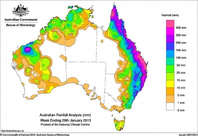
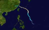
40 Case: Oswald (2013)

 and Bundaberg (Bun)")
41 Case: Oswald (2013) B Observed Deterministic NWP output for the 24 hours to 00 UTC on the 27 Jan 2013 (from 12 UTC runs on 25 Jan). The cities of Brisbane (Bris) and Bundaberg (Bun) are also shown.

42 Case: Oswald (2013)

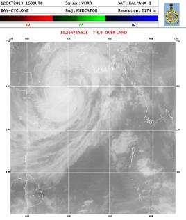

43 Case: Phailin (2013)

44 Case: Rammasun (2014) Affected 11 million people. 62 killed and 21 went missing. Economic loss amounted to several US billion. Evacuated 180,000 people within 25 km radius of landfall site
45 Lessons and Inspirations from Notable Cases TC Kompasu & Lionrock (2011) Fitow (2013) Talas (2011) Irene (2011) Sandy (2012) Oswald (2013) Phailin (2013) Rammasun (2014) Lessons / Inspirations Remote TC Rainfall Emergency Warning for exceptional extreme cases Inland TC Rainfall TC precipitation in the form of Snow Extreme rainfall forecast
46 Summary New ways to observe precipitation emerged. Many QPE and QPF methods/systems developed and became operational Several notable cases reviewed Emergency Warning Remote TC rainfall needs more work Extreme QPF remains a challenge
47 Q&A
Probabilistic Quantitative Precipitation Forecasts for Tropical Cyclone Rainfall
 Probabilistic Quantitative Precipitation Forecasts for Tropical Cyclone Rainfall WOO WANG CHUN HONG KONG OBSERVATORY IWTCLP-III, JEJU 10, DEC 2014 Scales of Atmospheric Systems Advection-Based Nowcasting
THIRD INTERNATIONAL WORKSHOP ON TROPICAL CYCLONES LANDFALL PROCESSES TOPIC 8: RAINFALL YU HUI SHANGHAI TYPHOON INSTITUTE/CMA
 THIRD INTERNATIONAL WORKSHOP ON TROPICAL CYCLONES LANDFALL PROCESSES TOPIC 8: RAINFALL YU HUI SHANGHAI TYPHOON INSTITUTE/CMA WG MEMBERS FOR RESEARCH PART: RAPPORTEUR: TIMOTHY MARCHOK (NOAA/GFDL) DAN CECIL,
Briefing on the WMO Support to Viet Nam to cope with Typhoon Haiyan
 WMO Briefing on the WMO Support to Viet Nam to cope with Typhoon Haiyan A Case of WMO Emergency Response Typhoon Haiyan trajectory Background Typhoon Haiyan remained strong after devastating the Philippines
Application of NWP products and meteorological information processing system in Hong Kong
 Application of NWP products and meteorological information processing system in Hong Kong Y.S. Li Scientific Officer Hong Kong Observatory (ysli@hko.gov.hk) 7 million people Hong Kong ~1,100 km sq. Regional
QPE and QPF in the Bureau of Meteorology
 QPE and QPF in the Bureau of Meteorology Current and future real-time rainfall products Carlos Velasco (BoM) Alan Seed (BoM) and Luigi Renzullo (CSIRO) OzEWEX 2016, 14-15 December 2016, Canberra Why do
On the use of radar rainfall estimates and nowcasts in an operational heavy rainfall warning service
 On the use of radar rainfall estimates and nowcasts in an operational heavy rainfall warning service Alan Seed, Ross Bunn, Aurora Bell Bureau of Meteorology Australia The Centre for Australian Weather
Development Project High Resolution Numerical Prediction of Landfalling Typhoon Rainfall (tentative title)
") A Proposal for the WMO/WWRP Research and Development Project High Resolution Numerical Prediction of Landfalling Typhoon Rainfall (tentative title) Yihong Duan WGTMR Proposed in the side meeting of the
A Proposal for the WMO/WWRP Research and Development Project High Resolution Numerical Prediction of Landfalling Typhoon Rainfall (tentative title) Yihong Duan WGTMR Proposed in the side meeting of the
Emerging Needs, Challenges and Response Strategy
 Emerging Needs, Challenges and Response Strategy Development of Integrated Observing Systems in China JIAO Meiyan Deputy Administrator China Meteorological Administration September 2011 Geneva Outline
WEATHER AND CLIMATE EXTREMES MONITORING BASED ON SATELLITE OBSERVATION : INDONESIA PERSPECTIVE RIRIS ADRIYANTO
 WEATHER AND CLIMATE EXTREMES MONITORING BASED ON SATELLITE OBSERVATION : INDONESIA PERSPECTIVE RIRIS ADRIYANTO INDONESIA AGENCY FOR METEOROLOGY, CLIMATOLOGY AND GEOPHYSICS (BM KG) 1. INTRODUCTION - BMKG
7.17 RAPIDS A NEW RAINSTORM NOWCASTING SYSTEM IN HONG KONG
 7.17 RAPIDS A NEW RAINSTORM NOWCASTING SYSTEM IN HONG KONG Li Ping-Wah *, Wong Wai-Kin and Edwin S.T. Lai Hong Kong Observatory, 134A Nathan Road, Kowloon, Hong Kong 1. INTRODUCTION and the numerical forecast
Application of Satellite Data for Flood Forecasting and Early Warning in the Mekong River Basin in South-east Asia
 MEKONG RIVER COMMISSION Vientiane, Lao PDR Application of Satellite Data for Flood Forecasting and Early Warning in the Mekong River Basin in South-east Asia 4 th World Water Forum March 2006 Mexico City,
AVIATION APPLICATIONS OF A NEW GENERATION OF MESOSCALE NUMERICAL WEATHER PREDICTION SYSTEM OF THE HONG KONG OBSERVATORY
 P452 AVIATION APPLICATIONS OF A NEW GENERATION OF MESOSCALE NUMERICAL WEATHER PREDICTION SYSTEM OF THE HONG KONG OBSERVATORY Wai-Kin WONG *1, P.W. Chan 1 and Ivan C.K. Ng 2 1 Hong Kong Observatory, Hong
Recent development of the National Hydro-Meteorological Service (NHMS) of Viet Nam for disaster risk reduction
 of Viet Nam for disaster risk reduction") Ministry of Natural Resources and Environment National Hydro-Meteorological Service Recent development of the National Hydro-Meteorological Service (NHMS) of Viet Nam for disaster risk reduction Tran Van
Ministry of Natural Resources and Environment National Hydro-Meteorological Service Recent development of the National Hydro-Meteorological Service (NHMS) of Viet Nam for disaster risk reduction Tran Van
Evaluation of Flash flood Events Using NWP Model and Remotely Sensed Rainfall Estimates
 Evaluation of Flash flood Events Using NWP Model and Remotely Sensed Rainfall Estimates Dr. Ismail Yucel METU Civil Engineering Department and Fatih Keskin State Hydraulic Works HydroPredict 2010 Prague
AN OBSERVING SYSTEM EXPERIMENT OF MTSAT RAPID SCAN AMV USING JMA MESO-SCALE OPERATIONAL NWP SYSTEM
 AN OBSERVING SYSTEM EXPERIMENT OF MTSAT RAPID SCAN AMV USING JMA MESO-SCALE OPERATIONAL NWP SYSTEM Koji Yamashita Japan Meteorological Agency / Numerical Prediction Division 1-3-4, Otemachi, Chiyoda-ku,
Recent Improvement of Integrated Observation Systems in JMA
 Recent Improvement of Integrated Observation Systems in JMA Mr Osamu Suzuki and Mr Yoshihiko Tahara Japan Meteorological Agency 1-3-4 Otemachi, Chiyoda-ku, Tokyo 100-8122, Japan Tel: +81-3-3212-8341, Fax:
Joint Meeting of RA II WIGOS Project and RA V TT-SU on 11 October 2018 BMKG Headquarter Jakarta, Indonesia. Mrs. Sinthaly CHANTHANA
 Joint Meeting of RA II WIGOS Project and RA V TT-SU on 11 October 2018 BMKG Headquarter Jakarta, Indonesia Mrs. Sinthaly CHANTHANA Lao PDR Background Department of Meteorology and Hydrology ( DMH ) in
FLORA: FLood estimation and forecast in complex Orographic areas for Risk mitigation in the Alpine space
 Natural Risk Management in a changing climate: Experiences in Adaptation Strategies from some European Projekts Milano - December 14 th, 2011 FLORA: FLood estimation and forecast in complex Orographic
An Application of Hydrometeorological Information
 An Application of Hydrometeorological Information Weather-proof Café: Hydro-meteorological information in managing weather risks 17 19 November 2012 National Taiwan University, Chinese Taipei Nikos Viktor
Activities and Outlook related to Disaster Reduction in CMA
 Activities and Outlook related to Disaster Reduction in CMA WANG Bangzhong China Meteorological Administration March 15-17 2006 ADENDA Situation about MD and related disasters in CHINA Guidance for MD/RD
Impact of Tropical Cyclones - Malaysia's Experience
 Impact of Tropical Cyclones - Malaysia's Experience ALUI BAHARI MALAYSIAN METEOROLOGICAL DEPARTMENT MINISTRY OF SCIENCE, TECHNOLOGY AND INNOVATION SCOPE Introduction Case Studies of Tropical Cyclones Impacting
ME KONG RIVER COMMISSION FLASH FLOOD GUIDANCE SYSTEM (MRCFFGS)
") NATIONAL HYDRO-METEOROLOGICAL SERVICE IN VIETNAM NATIONAL CENTER FOR HYDRO-METEOROLOGICAL FORECASTING ME KONG RIVER COMMISSION FLASH FLOOD GUIDANCE SYSTEM (MRCFFGS) http://www.nchmf.gov.vn 29 Nov 1 Dec
NATIONAL HYDRO-METEOROLOGICAL SERVICE IN VIETNAM NATIONAL CENTER FOR HYDRO-METEOROLOGICAL FORECASTING ME KONG RIVER COMMISSION FLASH FLOOD GUIDANCE SYSTEM (MRCFFGS) http://www.nchmf.gov.vn 29 Nov 1 Dec
The National Weather Service of the Future: Building a Weather-Ready Nation
 The of the Future: Building a Weather-Ready Nation Dr. Louis W. Uccellini Director, NOAA Assistant Administrator for Weather Services NCEP Production Suite Review December 2, 2014 Outline Building a Weather-Ready
Aurora Bell*, Alan Seed, Ross Bunn, Bureau of Meteorology, Melbourne, Australia
 15B.1 RADAR RAINFALL ESTIMATES AND NOWCASTS: THE CHALLENGING ROAD FROM RESEARCH TO WARNINGS Aurora Bell*, Alan Seed, Ross Bunn, Bureau of Meteorology, Melbourne, Australia 1. Introduction Warnings are
Haiti and Dominican Republic Flash Flood Initial Planning Meeting
 Dr Rochelle Graham Climate Scientist Haiti and Dominican Republic Flash Flood Initial Planning Meeting September 7 th to 9 th, 2016 Hydrologic Research Center http://www.hrcwater.org Haiti and Dominican
National Report on Weather Forecasting Service
 MINISTRY OF WATER RESOURCES AND METEOROLOGY DEPARTMENT OF METEOROLOGY, CAMBODIA National Report on Weather Forecasting Service Tokyo, 11-15 March 2014 Department of Meteorology, Cambodia Presentation Outline
The 5th Meeting of the Coordinating Group of the RA II WIGOS Satellite Project
 The 5th Meeting of the Coordinating Group of the RA II WIGOS Satellite Project 21 October, Vladivostok city, Russky Island, Russia Far Eastern Federal University Hong Kong, China Mr. C.K.So, Scientific
Nowcasting techniques in use for severe weather operation in NMC/CMA
 WWRP NMRWG Buenos Aires Aug 2017 Nowcasting techniques in use for severe weather operation in NMC/CMA Jianjie WANG National Meteorological Center, CMA Cascading Weather Forecasting Process --- different
Observing system experiments of MTSAT-2 Rapid Scan Atmospheric Motion Vector for T-PARC 2008 using the JMA operational NWP system
 Tenth International Winds Workshop 1 Observing system experiments of MTSAT-2 Rapid Scan Atmospheric Motion Vector for T-PARC 2008 using the JMA operational NWP system Koji Yamashita Japan Meteorological
Striving Sufficient Lead Time of Flood Forecasts via Integrated Hydro-meteorological Intelligence
 Striving Sufficient Lead Time of Flood Forecasts via Integrated Hydro-meteorological Intelligence Dong-Sin Shih Assistant Professor, National Chung Hsing University, Taiwan, Sep. 6, 2013 Outlines Introductions
A new operational convection-permitting NWP system for tropical cyclone forecasting in the SW Indian Ocean
 A new operational convection-permitting NWP system for tropical cyclone forecasting in the SW Indian Ocean Olivier BOUSQUET, Soline BIELLI, David BARBARY, Marie-Dominique LEROUX, Christelle BARTHE, Dominique
Tokyo, Japan March Discussed By: May Khin Chaw, Kyaw Lwin Oo. Department of Meteorology and Hydrology
 Tokyo, Japan 11-14 March 2014 Discussed By: May Khin Chaw, Kyaw Lwin Oo Department of Meteorology and Hydrology Manpower: Out of DMH s total (1425), we are Working with (780) Staffs. 55% (37) stations
Global Flood Alert System based on satellite derived rainfall data -Targeting the era of Global Precipitation Measurement (GPM)-
-") Global Flood Alert System based on satellite derived rainfall data -Targeting the era of Global Precipitation Measurement (GPM)- Riko Oki, Misako Kachi (JAXA/EORC) Kazuhiko Fukami (PWRI) and Kazuo Umeda
Global Flood Alert System based on satellite derived rainfall data -Targeting the era of Global Precipitation Measurement (GPM)- Riko Oki, Misako Kachi (JAXA/EORC) Kazuhiko Fukami (PWRI) and Kazuo Umeda
Masahiro Kazumori, Takashi Kadowaki Numerical Prediction Division Japan Meteorological Agency
 Development of an all-sky assimilation of microwave imager and sounder radiances for the Japan Meteorological Agency global numerical weather prediction system Masahiro Kazumori, Takashi Kadowaki Numerical
Be relevant and effective thinking beyond accuracy and timeliness
 The Fourth Technical Conference on the Management of Meteorological and Hydrological Services in WMO RA II (Asia) Be relevant and effective thinking beyond accuracy and timeliness C. Y. LAM Hong Kong Observatory
The Properties of Convective Clouds Over the Western Pacific and Their Relationship to the Environment of Tropical Cyclones
 The Properties of Convective Clouds Over the Western Pacific and Their Relationship to the Environment of Tropical Cyclones Principal Investigator: Dr. Zhaoxia Pu Department of Meteorology, University
The Impacts of GPS Radio Occultation Data on the Analysis and Prediction of Tropical Cyclones. Bill Kuo, Xingqin Fang, and Hui Liu UCAR COSMIC
 The Impacts of GPS Radio Occultation Data on the Analysis and Prediction of Tropical Cyclones Bill Kuo, Xingqin Fang, and Hui Liu UCAR COSMIC GPS Radio Occultation α GPS RO observations advantages for
The Use of GPS Radio Occultation Data for Tropical Cyclone Prediction. Bill Kuo and Hui Liu UCAR
 The Use of GPS Radio Occultation Data for Tropical Cyclone Prediction Bill Kuo and Hui Liu UCAR Current capability of the National Hurricane Center Good track forecast improvements. Errors cut in half
TECHNICAL PRESENTATIONS TC49 Item 5 of TC49 Agenda
 TECHNICAL PRESENTATIONS TC49 Item 5 of TC49 Agenda No. Time TITLE ABSTRACT 1 2 3 11:40 12:00 12:00 12:20 12:20-13:50 13:50 14:05 Regional component of IN-MHEWS (International Network for Multi-hazard Early
Heavy Rain/Flooding September 8-10 Associated with Tropical Storm Etau
 Heavy Rain/Flooding September 8-10 Associated with Tropical Storm Etau Wx Files Vol.32 September 24, 2015 Tropical Storm Etau made landfall over the Chita Peninsula in Aichi just after 10:00 AM on September
Fernando Prates. Evaluation Section. Slide 1
 Fernando Prates Evaluation Section Slide 1 Objectives Ø Have a better understanding of the Tropical Cyclone Products generated at ECMWF Ø Learn the recent developments in the forecast system and its impact
DETECTION AND FORECASTING - THE CZECH EXPERIENCE
 1 STORM RAINFALL DETECTION AND FORECASTING - THE CZECH EXPERIENCE J. Danhelka * Czech Hydrometeorological Institute, Prague, Czech Republic Abstract Contribution presents the state of the art of operational
Use of NWP and EPS Products in support of Location-specific Forecasts
 First International Workshop on Prevention and Migration of Meteorological Disasters in Southeast Asia Use of NWP and EPS Products in support of Location-specific Forecasts Edwin S.T. Lai Hong Kong Observatory
Assimilation of Himawari-8 Atmospheric Motion Vectors into the Numerical Weather Prediction Systems of Japan Meteorological Agency
 Assimilation of Himawari-8 Atmospheric Motion Vectors into the Numerical Weather Prediction Systems of Japan Meteorological Agency Koji Yamashita Japan Meteorological Agency kobo.yamashita@met.kishou.go.jp,
Preliminary assessment of socio-economic benefits from CMA Meteorological Satellite Programmes. Dr. ZHENG Guoguang / YANG Jun
 Preliminary assessment of socio-economic benefits from CMA Meteorological Satellite Programmes Dr. ZHENG Guoguang / YANG Jun China Meteorological Administration CMA report to CM-12 WMO HQ, June 21, 2014
11/17/2017. Memorable Hurricanes of 2004 MET 4532
 MET 4532 2004 Hurricane Season Lecture 31 & 32 2004, 2005, and After 17-20 November 2017 1 2 Memorable Hurricanes of 2004 Hurricane Dates Damage (US) Deaths (US) Charlie (4) 9-14 AUG $14B 10 Ivan (4) 2-24
Tonga Country Report
 Tonga Country Report Tonga Meteorological Services Ph. (676)35355 email: metstaff@met.gov.to Joint Meeting of RA II WIGOS Project and RA V TT-SU Jakarta, Indonesia / 11 October 2018 BMKG Headquarter Outline
Strategic Radar Enhancement Project (SREP) Forecast Demonstration Project (FDP) The future is here and now
 Forecast Demonstration Project (FDP) The future is here and now") Strategic Radar Enhancement Project (SREP) Forecast Demonstration Project (FDP) The future is here and now Michael Berechree National Manager Aviation Weather Services Australian Bureau of Meteorology
Strategic Radar Enhancement Project (SREP) Forecast Demonstration Project (FDP) The future is here and now Michael Berechree National Manager Aviation Weather Services Australian Bureau of Meteorology
Reduction of the Radius of Probability Circle. in Typhoon Track Forecast
 Reduction of the Radius of Probability Circle in Typhoon Track Forecast Nobutaka MANNOJI National Typhoon Center, Japan Meteorological Agency Abstract RSMC Tokyo - Typhoon Center of the Japan Meteorological
Real-Time Meteorological Gridded Data: What s New With HEC-RAS
 Real-Time Meteorological Gridded Data: What s New With HEC-RAS Acquisition and Application of Gridded Meteorological Data in Support of the USACE s Real-Time Water Management Mission Fauwaz Hanbali, Tom
Spaceborne and Ground-based Global and Regional Precipitation Estimation: Multi-Sensor Synergy
 Hydrometeorology and Remote Sensing Lab (hydro.ou.edu) at The University of Oklahoma Spaceborne and Ground-based Global and Regional Precipitation Estimation: Multi-Sensor Synergy Presented by: 温逸馨 (Berry)
Goal 2: Development of a regional cloud-resolving ensemble analysis and forecast systems ( )
") Goal 2: Development of a regional cloud-resolving ensemble analysis and forecast systems ( ) Meteorological Research Institute, Japan Agency for Marine-Earth Science and Technology, Japan Meteorological
Goal 2: Development of a regional cloud-resolving ensemble analysis and forecast systems ( ) Meteorological Research Institute, Japan Agency for Marine-Earth Science and Technology, Japan Meteorological
Flash flood forecasting and warning infrastructures of National Meteorology and Hydrological Services of Cambodia
 Development and Implementation of the South East Asia Flash Flood Guidance System (SEAFFGS) Ha Noi, Viet Nam, 20-23 November 2017 Flash flood forecasting and warning infrastructures of National Meteorology
Rainwater storage facilities
 Rainwater storage facilities Development of facilities for target rainfall Planned discharge in pump drainage areas City Yokohama Kawasaki Total Discharge area Tsuzuki Kouhoku Hokubu Kase Planned discharge
JMA/WMO WORKSHOP ON EFFECTIVE TROPICAL CYCLONE WARNING IN SOUTHEAST ASIA
 JMA/WMO WORKSHOP ON EFFECTIVE TROPICAL CYCLONE WARNING IN SOUTHEAST ASIA TROPICAL CYCLONE MONITORING IN LAO PDR TOKYO, JAPAN 11 14 March 2014 Ministry of Natural Resource and Environment (MONRE) Department
M. Mohapatra and D. R. Pattanaik
 Understanding and forecasting of intra-seasonal extremes of southwest monsoon circulation and precipitation over India M. Mohapatra and D. R. Pattanaik IMD, New Delhi Email : m.mohapatra@imd.gov.in Annual
JMA Contribution to SWFDDP in RAV. (Submitted by Yuki Honda and Masayuki Kyouda, Japan Meteorological Agency) Summary and purpose of document
 Summary and purpose of document") WORLD METEOROLOGICAL ORGANIZATION COMMISSION FOR BASIC SYSTEMS OPAG on DPFS DPFS/RAV-SWFDDP-RSMT Doc. 7.1(1) (28.X.2010) SEVERE WEATHER FORECASTING AND DISASTER RISK REDUCTION DEMONSTRATION PROJECT (SWFDDP)
WORLD METEOROLOGICAL ORGANIZATION COMMISSION FOR BASIC SYSTEMS OPAG on DPFS DPFS/RAV-SWFDDP-RSMT Doc. 7.1(1) (28.X.2010) SEVERE WEATHER FORECASTING AND DISASTER RISK REDUCTION DEMONSTRATION PROJECT (SWFDDP)
NOAA Hurricane Forecast Improvement Project
 NOAA Hurricane Forecast Improvement Project Fred Toepfer Hurricane Forecast Improvement Project Manager November 9 th, 2009 Outline NOAA Hurricane Forecast Improvement Project Driving Issue Purpose NOAA
Application and verification of ECMWF products 2016
 Application and verification of ECMWF products 2016 Icelandic Meteorological Office (www.vedur.is) Bolli Pálmason and Guðrún Nína Petersen 1. Summary of major highlights Medium range weather forecasts
High Resolution (20-km Mesh) Global Climate Model and Projected Hydro- Meteorological Extremes in the Future. Akio Kitoh
 Global Climate Model and Projected Hydro- Meteorological Extremes in the Future. Akio Kitoh") 2011.6.29, U-02, IUGG, Melbourne High Resolution (20-km Mesh) Global Climate Model and Projected Hydro- Meteorological Extremes in the Future Akio Kitoh Climate Research Department Meteorological Research
2011.6.29, U-02, IUGG, Melbourne High Resolution (20-km Mesh) Global Climate Model and Projected Hydro- Meteorological Extremes in the Future Akio Kitoh Climate Research Department Meteorological Research
JMA/WMO WORKSHOP ON EFFECTIVE TROPICAL CYCLONE WARNING IN SOUTHEAST ASIA. Tokyo, Japan March 2014
 Annex IV JMA/WMO WORKSHOP ON EFFECTIVE TROPICAL CYCLONE WARNING IN SOUTHEAST ASIA Tokyo, Japan 11-14 March 2014 Country Report On Tropical Cyclone Monitoring In Cambodia Department of Meteorology 1 1.
The WMO Integrated Global Observing System (WIGOS), current status and planned regional activities
, current status and planned regional activities") The WMO Integrated Global Observing System (WIGOS), current status and planned regional activities Dr. Lars Peter Riishojgaard WMO Secretariat, Geneva Outline Introduction to WIGOS WMO The Rolling Review
The WMO Integrated Global Observing System (WIGOS), current status and planned regional activities Dr. Lars Peter Riishojgaard WMO Secretariat, Geneva Outline Introduction to WIGOS WMO The Rolling Review
Impact assessment on disasters
 The 5th International Coordination Group (ICG) Meeting GEOSS Asian Water Cycle Initiative (AWCI), Dec. 16, 2009. Impact assessment on disasters Eiichi Nakakita Disaster Prevention Research Institute Kyoto
- Introduction - Technical Presentation 49 th Session of the Typhoon Committee. Yokohama, Japan 21 February Munehiko Yamaguchi
 - Introduction - The Latest Model Simulation and Observational Studies related to Tropical Cyclone in Japan Technical Presentation 49 th Session of the Typhoon Committee Yokohama, Japan 21 February 2017
Add NOAA nowcoast Layers to Maps
 WebEOC Maps Add-on Quick Reference Guide Add NOAA nowcoast Layers to Maps Overview With Maps Add-on, you can configure an unlimited number of map layers. These layers allow you to control the data you
Japanese Programs on Space and Water Applications
 Japanese Programs on Space and Water Applications Tamotsu IGARASHI Remote Sensing Technology Center of Japan June 2006 COPUOS 2006 Vienna International Centre Water-related hazards/disasters may occur
Smart use of Geographic Information System (GIS) platform for delivering weather information and nowcasting services
 platform for delivering weather information and nowcasting services") Smart use of Geographic Information System (GIS) platform for delivering weather information and nowcasting services C. K. Pan Hong Kong Observatory Hong Kong, China It is a world of beauty Source: Image
Smart use of Geographic Information System (GIS) platform for delivering weather information and nowcasting services C. K. Pan Hong Kong Observatory Hong Kong, China It is a world of beauty Source: Image
Flood Forecasting with Radar
 Flood Forecasting with Radar Miguel Angel Rico-Ramirez m.a.rico-ramirez@bristol.ac.uk Encuentro Internacional de Manejo del Riesgo por Inundaciones, UNAM, 22 th Jan 2013 Talk Outline Rainfall estimation
ACTIVITIES OF THE RSMC TOKYO - TYPHOON CENTER IN 2010
 ECONOMIC AND SOCIAL COMMISSION FOR ASIA AND THE PACIFIC AND WORLD METEOROLOGICAL ORGANIZATION WRD/TC.43/5.1 Add. 2 18 January 2011 Typhoon Committee Forty Third Session 17 to 22 January 2011 Jeju, Republic
A new mesoscale NWP system for Australia
 A new mesoscale NWP system for Australia www.cawcr.gov.au Peter Steinle on behalf of : Earth System Modelling (ESM) and Weather&Environmental Prediction (WEP) Research Programs, CAWCR Data Assimilation
Challenges in providing effective flood forecasts and warnings
 Challenges in providing effective flood forecasts and warnings National Centre for Flood Research Inaugural Symposium Justin Robinson Bureau of Meteorology October 2018 Zero Lives Lost A key responsibility
Improvement and Ensemble Strategy of Heavy-Rainfall Quantitative Precipitation Forecasts using a Cloud-Resolving Model in Taiwan
 Improvement and Ensemble Strategy of Heavy-Rainfall Quantitative Precipitation Forecasts using a Cloud-Resolving Model in Taiwan Chung-Chieh Wang Department of Earth Sciences, National Taiwan Normal University,
HISTORY OF HEAVY RAINFALL DISASTER INFORMATION IN JAPAN
 transmission, for a state-of-the-art review. In addition, issues expected to arise in the future are discussed. HISTORY OF HEAVY RAINFALL DISASTER INFORMATION IN JAPAN Progress of Rainfall Observation
Recent Developments of JMA Operational NWP Systems and WGNE Intercomparison of Tropical Cyclone Track Forecast
 Recent Developments of JMA Operational NWP Systems and WGNE Intercomparison of Tropical Cyclone Track Forecast Chiashi Muroi Numerical Prediction Division Japan Meteorological Agency 1 CURRENT STATUS AND
Complete Weather Intelligence for Public Safety from DTN
 Complete Weather Intelligence for Public Safety from DTN September 2017 White Paper www.dtn.com / 1.800.610.0777 From flooding to tornados to severe winter storms, the threats to public safety from weather-related
COUNTRY PRESENTATION ON MR JAYNAL ABEDIN JOINT SECRETARY ( WORKS & DEVELOPMENT ) MINISTRY OF DEFENCE
 MINISTRY OF DEFENCE") COUNTRY PRESENTATION ON By MR JAYNAL ABEDIN JOINT SECRETARY ( WORKS & DEVELOPMENT ) MINISTRY OF DEFENCE Bangladesh Geographical Location of Bangladesh Bangladesh Country at a Glance Physical Features 1,230
COUNTRY PRESENTATION ON By MR JAYNAL ABEDIN JOINT SECRETARY ( WORKS & DEVELOPMENT ) MINISTRY OF DEFENCE Bangladesh Geographical Location of Bangladesh Bangladesh Country at a Glance Physical Features 1,230
Workshop on MCCOE Radar Meteorology /Climatology in Indonesia. Segel Ginting Wanny K. Adidarma
 Workshop on MCCOE Radar Meteorology /Climatology in Indonesia BPPT, 28 Februari 2013 JAKARTA FLOOD EARLY WARNING SYSTEM (J-FEWS) Segel Ginting Wanny K. Adidarma JCP (Joint Cooperation Program) Indonesia
Hurricane Floyd Symposium. Satellite Precipitation as a Tool to Reanalyze Hurricane Floyd and Forecast Probabilities of Extreme Rainfall
 Sept. 18, 2009 Hurricane Floyd Symposium Scott Curtis, East Carolina Universtiy Satellite Precipitation as a Tool to Reanalyze Hurricane Floyd and Forecast Probabilities of Extreme Rainfall What was the
Meteorological Hazards and Current Approach to Observing, Modelling and Predicting Severe Events in Sri Lanka
 Regional Workshop on Impact-based Forecasts in RA II (Asia) 7-9, November, 2017, Seoul, Republic of Korea Meteorological Hazards and Current Approach to Observing, Modelling and Predicting Severe Events
Outline. Research Achievements
 Taiwan Typhoon and Flood Research Institute, National Applied Research Laboratories 11F., No.97, Sec. 1, Roosevelt Rd., Zhongzheng Dist., Taipei City 10093, Taiwan (R.O.C.) http://www.ttfri.narl.org.tw/eng/index.html
11/19/14. Chapter 11: Hurricanes. The Atmosphere: An Introduction to Meteorology, 12 th. Lutgens Tarbuck
 Chapter 11: Hurricanes The Atmosphere: An Introduction to Meteorology, 12 th Lutgens Tarbuck Lectures by: Heather Gallacher, Cleveland State University! Hurricanes: " Hurricanes are intense centers of
Lecture 4b: Meteorological Satellites and Instruments. Acknowledgement: Dr. S. Kidder at Colorado State Univ.
 Lecture 4b: Meteorological Satellites and Instruments Acknowledgement: Dr. S. Kidder at Colorado State Univ. US Geostationary satellites - GOES (Geostationary Operational Environmental Satellites) US
P1.10 Synchronization of Multiple Radar Observations in 3-D Radar Mosaic
 Submitted for the 12 th Conf. on Aviation, Range, and Aerospace Meteor. 29 Jan. 2 Feb. 2006. Atlanta, GA. P1.10 Synchronization of Multiple Radar Observations in 3-D Radar Mosaic Hongping Yang 1, Jian
Global and Regional OSEs at JMA
 Global and Regional OSEs at JMA Yoshiaki SATO and colleagues Japan Meteorological Agency / Numerical Prediction Division 1 JMA NWP SYSTEM Global OSEs Contents AMSU A over coast, MHS over land, (related
At the start of the talk will be a trivia question. Be prepared to write your answer.
 Operational hydrometeorological forecasting activities of the Australian Bureau of Meteorology Thomas Pagano At the start of the talk will be a trivia question. Be prepared to write your answer. http://scottbridle.com/
Judit Kerényi. OMSZ - Hungarian Meteorological Service, Budapest, Hungary. H-1525 Budapest, P.O.Box 38, Hungary.
 SATELLITE-DERIVED PRECIPITATION ESTIMATIONS DEVELOPED BY THE HYDROLOGY SAF PROJECT CASE STUDIES FOR THE INVESTIGATION OF THEIR ACCURACY AND FEATURES IN HUNGARY Judit Kerényi OMSZ - Hungarian Meteorological
THE APPLICATION OF VISIBLE IMAGES FROM METEOROLOGICAL SATELLITE (METSAT) FOR THE RAINFALL ESTIMATION IN KLANG RIVER BASIN
 FOR THE RAINFALL ESTIMATION IN KLANG RIVER BASIN") THE APPLICATION OF VISIBLE IMAGES FROM METEOROLOGICAL SATELLITE (METSAT) FOR THE RAINFALL ESTIMATION IN KLANG RIVER BASIN Intan Shafeenar Ahmad Mohtar and Wardah Tahir Faculty of Civil Engineering, Universiti
THE APPLICATION OF VISIBLE IMAGES FROM METEOROLOGICAL SATELLITE (METSAT) FOR THE RAINFALL ESTIMATION IN KLANG RIVER BASIN Intan Shafeenar Ahmad Mohtar and Wardah Tahir Faculty of Civil Engineering, Universiti
H-SAF future developments on Convective Precipitation Retrieval
 H-SAF future developments on Convective Precipitation Retrieval Francesco Zauli 1, Daniele Biron 1, Davide Melfi 1, Antonio Vocino 1, Massimiliano Sist 2, Michele De Rosa 2, Matteo Picchiani 2, De Leonibus
Assimilation of Doppler radar observations for high-resolution numerical weather prediction
 Assimilation of Doppler radar observations for high-resolution numerical weather prediction Susan Rennie, Peter Steinle, Mark Curtis, Yi Xiao, Alan Seed Introduction Numerical Weather Prediction (NWP)
RGB Experts and Developers Workshop 2017 Tokyo, Japan
 "Application of the Sandwich Product and variations to this as used by Australian Forecasters and as presented during training at the Australian VLab Centre of Excellence". RGB Experts and Developers Workshop
Merging Nowcasting and NWP in Weather Warning Operations, with Special Reference to Landslides. C C Lam Hong Kong Observatory Hong Kong, China
 Merging Nowcasting and NWP in Weather Warning Operations, with Special Reference to Landslides C C Lam Hong Kong Observatory Hong Kong, China 1. Introduction In support of weather forecast and warning
Near-surface weather prediction and surface data assimilation: challenges, development, and potential data needs
 Near-surface weather prediction and surface data assimilation: challenges, development, and potential data needs Zhaoxia Pu Department of Atmospheric Sciences University of Utah, Salt Lake City, Utah,
The Role of PAGASA in Disaster Mitigation
 The Role of PAGASA in Disaster Mitigation Christopher F. Perez 2017 ACTS Workshop on Extreme Weather Forecast and Water Resource Management Hanoi, Vietnam September 26-27, 2017 Tropical Storm AMANG(Mekkhala),
Activity Report for Australian TCWCs 2009/2012
 Activity Report for Australian TCWCs 2009/2012 7th RSMC/TCWC Co-ordination Meeting Citeko, November 2012 Mike Bergin Regional Director (Western Australia) Bureau of Meteorology Outline Significant Cyclones
CHAPTER 13 WEATHER ANALYSIS AND FORECASTING MULTIPLE CHOICE QUESTIONS
 CHAPTER 13 WEATHER ANALYSIS AND FORECASTING MULTIPLE CHOICE QUESTIONS 1. The atmosphere is a continuous fluid that envelops the globe, so that weather observation, analysis, and forecasting require international
1st MAHASRI/AMY Workshop January 8, 2007 University of Tokyo, JAPAN Operational Hydro-Meteorological Facility of Vietnam
 1st MAHASRI/AMY Workshop January 8, 2007 University of Tokyo, JAPAN Operational Hydro-Meteorological Facility of Vietnam Nguyen Thi Tan Thanh National Hydro Meteorological Service (NHMS) of Vietnam content
Precipitation Structure and Processes of Typhoon Nari (2001): A Modeling Propsective
: A Modeling Propsective") Precipitation Structure and Processes of Typhoon Nari (2001): A Modeling Propsective Ming-Jen Yang Institute of Hydrological Sciences, National Central University 1. Introduction Typhoon Nari (2001) struck
Precipitation Structure and Processes of Typhoon Nari (2001): A Modeling Propsective Ming-Jen Yang Institute of Hydrological Sciences, National Central University 1. Introduction Typhoon Nari (2001) struck
Short Discription of NMHS Activity
 The 5th Meeting of the Coordinating Group of the RA II WIGOS Satellite Project 21 October, Vladivostok city, Russky Island, Russia Far Eastern Federal University FSM COUNTRY REPORT SOSTEN SOS, WSS OFFICE
Regional Flash Flood Guidance and Early Warning System
 WMO Training for Trainers Workshop on Integrated approach to flash flood and flood risk management 24-28 October 2010 Kathmandu, Nepal Regional Flash Flood Guidance and Early Warning System Dr. W. E. Grabs
PAGASA s Expectations of New-generation Satellites for Hazard Monitoring
 Country Report Philippines PAGASA s Expectations of New-generation Satellites for Hazard Monitoring VICENTE P. PALCON, JR. (Assistant Weather Services Chief) Weather Division- PAGASA DOST Email: vppalconjr@pagasa.dost.gov.ph