Striving Sufficient Lead Time of Flood Forecasts via Integrated Hydro-meteorological Intelligence
|
|
|
- Rodney Lambert
- 5 years ago
- Views:
Transcription
1 Striving Sufficient Lead Time of Flood Forecasts via Integrated Hydro-meteorological Intelligence Dong-Sin Shih Assistant Professor, National Chung Hsing University, Taiwan, Sep. 6, 2013
2 Outlines Introductions Integrated hydro meteorological simulations Ensemble Quantitative Precipitation Forecasts Experiment, Unified Regional Circulation Rainfall and Hydrological Watershed Model, Modeling Test-bed with Integrating Simulations/Observations/Assimilations in Demo Site, To improve our understandings from individual ensemble flood forecasts. Summary Page 2 / 32
3 Introductions Page 3 / 32


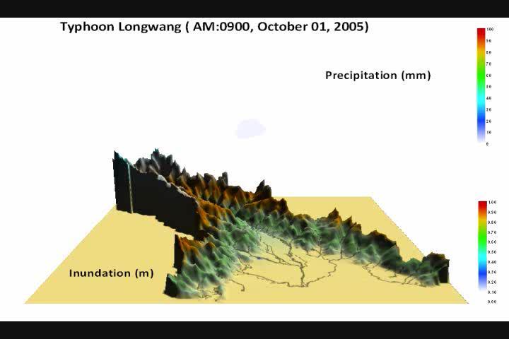
4 Introduction (Rainfalls) Taiwan, located in the subtropical zone of the west Pacific Ocean, often experiences typhoons accompanied by frequent flooding. During the summer season, an average of 3 to 4 typhoons make landfall, usually producing massive amounts of precipitation island-wide. The total amount of annual rainfall is more than 2,500 millimeters. The total amount of rainfall is almost 2.6 times the world s average. Page 4 / 32

5 Motive (Floods) During the rainy season, excessive torrential rain tends to cause flash floods, sometimes with devastating effects on people s lives and property. In recent decades, Taiwan has particularly suffered from severe attacks of torrential rain. Almost 73 percent of the population of the island are under threats from more than three of major natural disasters. Typhoon induced flood is the major natural threat to the island. Page 5 / 32


6 Introduction (Environment) The topography of Taiwan is steep and as a consequence its rivers are short and fastmoving, so are prone to frequent flooding following extreme precipitation. This is particularly the case in Taiwan which is covered by varied terrain with most watersheds being located in mountainous regions. Due to such steep landforms, we could only gain 3-5 hours of hydraulic response time when flash floods occur. It is necessary to establish a flood warning system to alert the population for possible evacuations. Page 6 / 32
7 TTFRI It is unquestionable that accurate rainfall prediction is the most crucial factor driving the hydrological response. It is also important to have very dense observations to provide the initial conditions via assimilation for hydrological modeling. How to integrate useful early information and condense the forecasting process is of great concern. This study aims at understanding the distinctive features of flood forecasts that are based on integrated rainfall-runoff simulations.. Page 7 / 32
8 Integrated Hydro meteorological Simulations Page 8 / 32


9 Field Observations Hydro meteorological System Ensemble Forecasts for Quantitatively Precipitation Experiments A quantitative precipitation experiment has been examined in Taiwan since Over 20 members of ensemble rainfall forecasts are generated by Weather Research Forecasting (WRF) Model. Hydro-Meteorological Simulation in Watershed Scale Hydrology A hydrology model, WASH123D, was sequentially employed to flood routing. Field observations are real-time received, and put into model simulations with feedback control. Warning Messages Display/Plot All procedures were scheduled and triggered in sequence with controlled by computer program. Simulation results are automatically extracted from modeling outputs and exhibited on the proposed platform. Page 9 / 32


10 track errors(km) The Experiment of Ensemble Quantitative Precipitation Forecasts 5 typhoons(36) 19/02LT NOGAPS JMA UK NCEP CWB TTFRI MEAN 0 12h(36) 24h(35) 36h(31) 48h(28) 60h(25) 72h(23) Forecast time (cases) 10/18 18:48 10/19 20:50 10/20 18:36 10/21 18:07 10/ ~ 10/ / ~ 10/ / ~ 10/ / ~ 10/ Page 10 / 32
11 W a te r S ta g e (m ) W a te r S ta g e (m ) R a in fa ll in te n s ity (m m /h r) R a in fa ll in te n s ity (m m /h r) Hydrological Routing 16 0 Model configurations Combining instantaneous field observations to provide initial accurate modeling. 8 4 T y p h o o n A R E A ( A u g.2 3 rd ~ A u g.2 6 th, ) O b s e rv e Sim ulate M A E : m R M S E : m Estimating infiltration for determining effective rainfall. 0 8 / 2 3 / 1 4 :0 0 8 / 2 4 / 0 1 :0 0 8 / 2 4 / 1 2 :0 0 8 / 2 4 / 2 3 :0 0 8 / 2 5 / 1 0 :0 0 8 / 2 5 / 2 1 :0 0 T im e (m /d /h o u r) Hydro-meteorological simulations Improving our understanding of Flood Forecasting. 8 T y p h o o n N A N M A D O L ( D e c.0 3 rd ~ D e c.0 4 th, ) O b s e rv e Sim ulate M A E : m 120 R M S E : m / 3 / 0 1 : / 3 / 1 0 : / 3 / 1 9 : / 4 / 0 4 : / 4 / 1 3 : / 4 / 2 2 :0 0 T im e (m /d /h o u r) Page 11 / 32
12 Display Page 12 / 32
13 Operational Warning System 24 hr 48 hr 72 hr am08:00, hydro-meteorological simulation done am06:00, QPF-process done, and start hydrological routing am04:00, Get NCEP-gfs data, and start rainfalls generation am00:00, Start operational process Page 13 / 32


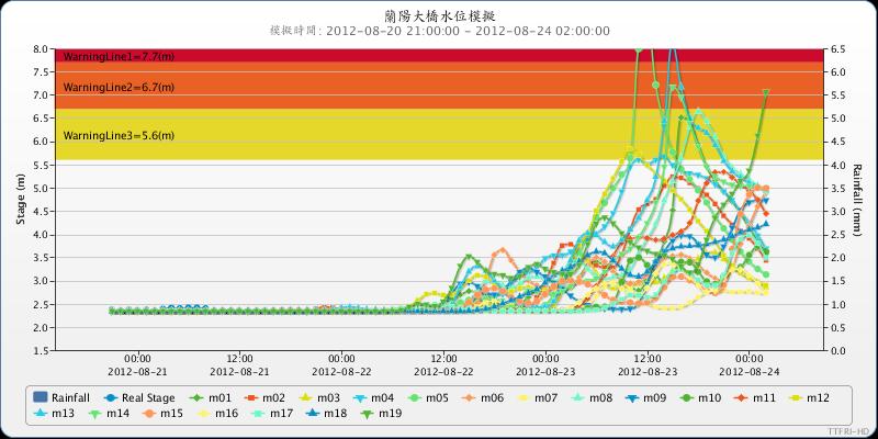
14 Study Site Study site The Langyang creek basin, situated in Northeastern Taiwan, covering an area of 978 km 2. Page 14 / 32
15 Model Configurations We discretized the computational domain with finite element meshes using line elements for rivers and triangular elements for land Table. Land use and Manning s roughness for the study site. Agricultural Forestry Traffic Water Buildings Others Land use 43.94% 19.08% 8.04% 4.65% 15.81% 8.48% Manning s N surface. Four sorts of Manning s roughness are assigned in studied river area based on the official reports, varying from to Land-use is classified into six types, as shown above, where the sets of Manning s value are calibrated in coupled 1-D/2-D systems. Page 15 / 32
16 Model Calibrations Model calibrations using Typhoon Sinluku and Jangmi. Event RMSE CE VER EQp Typhoon Sinluku Typhoon Jangmi Page 16 / 32
17 These two cases both show very small errors in total volume during this simulation period and captured the peak time exactly. In general, both cases reveal very good results for the coefficient of efficiency. It is noted that there is great improvement in the rising period of simulated hydrograph when the mechanism of infiltration is included. The simulated hydrograph tuned by artificial adjustments could precisely capture measured flow patterns. Page 17 / 32


18 Typhoon Megi (2010) Page 18 / 32

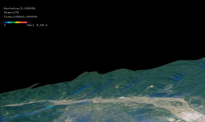
19 Figure. Hydro-meteorological simulations from the run that began at 18:00, Oct. 19 th of Page 19 / 32


20 Figure. Hydro-meteorological simulations from the run that began at 00:00, Oct. 20 th of Page 20 / 32

21 Figure. Hydro-meteorological simulations from the run that began at 12:00, Oct. 20 th of They warned the approach of a considerable flood, but could not reach an agreement on the peak time and related quantity. Page 21 / 32

22 Simulation using rain-gauge Model calibrations for Typhoon Magi. It seems easy to obtain a reasonable response using the measured rainfall to drive the watershed simulation. A perfect guess in terms of the quantity as well as distribution of precipitation is not easy to obtain. Although precipitation estimates produced by the WRF can capture the total amount of rainfall, its related distributions are sometimes inadequate for numerical hydrological modeling. Page 22 / 32
23 We should shift our expectations to the outcome of ensemble quantitative rainfall predictions. It is impossible to obtain a perfect guess in advance due to limitations in our understanding of the aspects of atmosphere and hydrology. The key is how to understand these types of information, and how to integrate earlier useful intelligence into the watershed model. Page 23 / 32
24 Typhoon Nalgae (2011) Page 24 / 32


25 Figure. Hydro-meteorological simulations from the run that began at 00:00, Oct. 02 nd of Page 25 / 32
26 Each rainfall participants has been chosen because of their individual representatives. The key to a flood warning system is not to expect too much of highly accurate quantitative precipitation forecasts, but to improve our understandings from individual ensemble flood forecasts. Therefore all participants are necessary to this QPF project with their own specific representatives conducting individual analysis. Page 26 / 32
27 This member captures the shapes of the predicted hydrograph poorly in the first few runs. They implied that a considerable flow peak would occur, but missed the time, which was behind the actual occurrence. They did not provide sufficient lead time for flood forecasts here. This actually provided very slight help. Page 27 / 32

28 The basically reveal that a flood is going to pass, but the precise time and peak are constantly being adjusted. They indeed provided some useful information for flood mitigation, because of being able to send out an early warning of the event. We can obtain some warning from early operational hydro-meteorological runs. To Issue advance warnings of possible danger is better than doing nothing. Page 28 / 32

29 The water stage for this event was incredibly high from the first to fourth operational predictions. The advantage in this case was that they always issued warning messages. This is helpful for mitigation of flash flood danger. Page 29 / 32

30 Summary Page 30 / 32
31 Concluding Remarks A system integrating rainfall-runoff calculations, field observations and instant data assimilations, is presented. Simulation results indicate that well calibrated coefficients of the hydrological model were not satisfied for sequential flood predictions. This is because these two types of precipitation data are systematically different because of the aspect of their generation. Page 31 / 32
32 Concluding Remarks Each QPF participants has been chosen because of their individual representatives. We must further understand that the key for such a warning system is not to have greatly expectations of highly accurate rainfall predictions, but to improve our understanding from the point of view of individual ensemble flood forecasts. Page 32 / 32
33 Thank You.
Outline. Research Achievements
 Taiwan Typhoon and Flood Research Institute, National Applied Research Laboratories 11F., No.97, Sec. 1, Roosevelt Rd., Zhongzheng Dist., Taipei City 10093, Taiwan (R.O.C.) http://www.ttfri.narl.org.tw/eng/index.html
U.S.-Taiwan Workshop on the Advancement of Societal Responses to Mega-Disasters afflicting Mega-Cities. Introduction of Taiwan Typhoon and
 U.S.-Taiwan Workshop on the Advancement of Societal Responses to Mega-Disasters afflicting Mega-Cities Introduction of Taiwan Typhoon and Flood Research Institute Ching-Yuang Huang TTFRI On behalf of Cheng-Shang
Improvement and Ensemble Strategy of Heavy-Rainfall Quantitative Precipitation Forecasts using a Cloud-Resolving Model in Taiwan
 Improvement and Ensemble Strategy of Heavy-Rainfall Quantitative Precipitation Forecasts using a Cloud-Resolving Model in Taiwan Chung-Chieh Wang Department of Earth Sciences, National Taiwan Normal University,
EFFICIENCY OF THE INTEGRATED RESERVOIR OPERATION FOR FLOOD CONTROL IN THE UPPER TONE RIVER OF JAPAN CONSIDERING SPATIAL DISTRIBUTION OF RAINFALL
 EFFICIENCY OF THE INTEGRATED RESERVOIR OPERATION FOR FLOOD CONTROL IN THE UPPER TONE RIVER OF JAPAN CONSIDERING SPATIAL DISTRIBUTION OF RAINFALL Dawen YANG, Eik Chay LOW and Toshio KOIKE Department of
Haiti and Dominican Republic Flash Flood Initial Planning Meeting
 Dr Rochelle Graham Climate Scientist Haiti and Dominican Republic Flash Flood Initial Planning Meeting September 7 th to 9 th, 2016 Hydrologic Research Center http://www.hrcwater.org Haiti and Dominican
GENERAL. CHAPTER 1 BACKGROUND AND PURPOSE OF THE GUIDELINES Background of the Guidelines Purpose of the Guidelines...
 GENERAL CHAPTER 1 BACKGROUND AND PURPOSE OF THE GUIDELINES... 1 1.1 Background of the Guidelines... 1 1.2 Purpose of the Guidelines... 3 CHAPTER 2 APPLICATION OF THE GUIDELINES... 3 2.1 Potential Users
Flash Flood Flash Flood Forecasting and Early Warning System (FFEWS)
") Stakeholder Workshop of Haor Area Livelihoods Improvement Project (HALIP) 15 January 2016, Sunamganj, Bangladesh Flash Flood Flash Flood Forecasting and Early Warning System (FFEWS) BUET Study Team Prof
Stakeholder Workshop of Haor Area Livelihoods Improvement Project (HALIP) 15 January 2016, Sunamganj, Bangladesh Flash Flood Flash Flood Forecasting and Early Warning System (FFEWS) BUET Study Team Prof
Flash Flood Guidance System On-going Enhancements
 Flash Flood Guidance System On-going Enhancements Hydrologic Research Center, USA Technical Developer SAOFFG Steering Committee Meeting 1 10-12 July 2017 Jakarta, INDONESIA Theresa M. Modrick Hansen, PhD
An Overview of Operations at the West Gulf River Forecast Center Gregory Waller Service Coordination Hydrologist NWS - West Gulf River Forecast Center
 National Weather Service West Gulf River Forecast Center An Overview of Operations at the West Gulf River Forecast Center Gregory Waller Service Coordination Hydrologist NWS - West Gulf River Forecast
THE DEVELOPMENT OF RAIN-BASED URBAN FLOOD FORECASTING METHOD FOR RIVER MANAGEMENT PRACTICE USING X-MP RADAR OBSERVATION
 Research Paper Advances in River Engineering, JSCE, Vol.19, 2013,June THE DEVELOPMENT OF RAIN-BASED URBAN FLOOD FORECASTING METHOD FOR RIVER MANAGEMENT PRACTICE USING X-MP RADAR OBSERVATION Seongsim YOON
THE 3D SIMULATION INFORMATION SYSTEM FOR ASSESSING THE FLOODING LOST IN KEELUNG RIVER BASIN
 THE 3D SIMULATION INFORMATION SYSTEM FOR ASSESSING THE FLOODING LOST IN KEELUNG RIVER BASIN Kuo-Chung Wen *, Tsung-Hsing Huang ** * Associate Professor, Chinese Culture University, Taipei **Master, Chinese
The Impacts of GPS Radio Occultation Data on the Analysis and Prediction of Tropical Cyclones. Bill Kuo, Xingqin Fang, and Hui Liu UCAR COSMIC
 The Impacts of GPS Radio Occultation Data on the Analysis and Prediction of Tropical Cyclones Bill Kuo, Xingqin Fang, and Hui Liu UCAR COSMIC GPS Radio Occultation α GPS RO observations advantages for
Operational Hydrologic Ensemble Forecasting. Rob Hartman Hydrologist in Charge NWS / California-Nevada River Forecast Center
 Operational Hydrologic Ensemble Forecasting Rob Hartman Hydrologist in Charge NWS / California-Nevada River Forecast Center Mission of NWS Hydrologic Services Program Provide river and flood forecasts
Evaluation of Flash flood Events Using NWP Model and Remotely Sensed Rainfall Estimates
 Evaluation of Flash flood Events Using NWP Model and Remotely Sensed Rainfall Estimates Dr. Ismail Yucel METU Civil Engineering Department and Fatih Keskin State Hydraulic Works HydroPredict 2010 Prague
TRANSBOUNDARY FLOOD FORECASTING THROUGH DOWNSCALING OF GLOBAL WEATHER FORECASTING AND RRI MODEL SIMULATION
 TRANSBOUNDARY FLOOD FORECASTING THROUGH DOWNSCALING OF GLOBAL WEATHER FORECASTING AND RRI MODEL SIMULATION Rashid Bilal 1 Supervisor: Tomoki Ushiyama 2 MEE15624 ABSTRACT The study comprise of a transboundary
Reduction of the Radius of Probability Circle. in Typhoon Track Forecast
 Reduction of the Radius of Probability Circle in Typhoon Track Forecast Nobutaka MANNOJI National Typhoon Center, Japan Meteorological Agency Abstract RSMC Tokyo - Typhoon Center of the Japan Meteorological
11/19/14. Chapter 11: Hurricanes. The Atmosphere: An Introduction to Meteorology, 12 th. Lutgens Tarbuck
 Chapter 11: Hurricanes The Atmosphere: An Introduction to Meteorology, 12 th Lutgens Tarbuck Lectures by: Heather Gallacher, Cleveland State University! Hurricanes: " Hurricanes are intense centers of
Satellite-based applications for water resources management in Asia and Pacific region
 Satellite-based applications for water resources management in Asia and Pacific region Ko Hamamoto Japan Aerospace Exploration Agency The views expressed in this paper/presentation are the views of the
Chapter-1 Introduction
 Modeling of rainfall variability and drought assessment in Sabarmati basin, Gujarat, India Chapter-1 Introduction 1.1 General Many researchers had studied variability of rainfall at spatial as well as
3/3/2013. The hydro cycle water returns from the sea. All "toilet to tap." Introduction to Environmental Geology, 5e
 Introduction to Environmental Geology, 5e Running Water: summary in haiku form Edward A. Keller Chapter 9 Rivers and Flooding Lecture Presentation prepared by X. Mara Chen, Salisbury University The hydro
Caribbean Early Warning System Workshop
 Caribbean Early Warning System Workshop Hamonization in Existing EWS April 14-16, 2016 Presenter: Shawn Boyce Caribbean Institute for Meteorology and Hydrology Husbands, St. James Barbados Background Between
A Comparison between Hurricane WRF and TWRF in Typhoon Track and Rainfall Forecast over the western North Pacific
 A Comparison between Hurricane WRF and TWRF in Typhoon Track and Rainfall Forecast over the western North Pacific Chin-Cheng TSAI 1, Ling-Feng HSIAO 1, Der Song CHEN 2, Jian-Wen BAO 3 1 Taiwan Typhoon
Quantitative Flood Forecasts using Short-term Radar Nowcasting
 Quantitative Flood Forecasts using Short-term Radar Nowcasting Enrique R. Vivoni *, Dara Entekhabi *, Rafael L. Bras *, Matthew P. Van Horne *, Valeri Y. Ivanov *, Chris Grassotti + and Ross Hoffman +
8 Current Issues and Research on Sediment Movement in the River Catchments of Japan
 8 Current Issues and Research on Sediment Movement in the River Catchments of Japan YUTAKA ICHIKAWA INTRODUCTION Prediction of sediment movement is one of the challenging tasks in water-related research.
Using the WRF-Hydro Model for 100 Years Flood Event in Israel
 Using the WRF-Hydro Model for 100 Years Flood Event in Israel Amir Givati, Israeli Hydrological Service, Erick Fredj, The Jerusalem College of Technology, Israel Thomas Rummler, university of Augsburg,
FFGS Additional Functionalities and Products. Konstantine P. Georgakakos, Sc.D. HYDROLOGIC RESEARCH CENTER 23 May 2018
 FFGS Additional Functionalities and Products Konstantine P. Georgakakos, Sc.D. HYDROLOGIC RESEARCH CENTER 23 May 2018 Advanced Functionalities 0. Multi-Model QPF A. Urban Flash Flood Warning B. Riverine
HEAVY RAIN OVER MID-CENTRAL REGION OF VIETNAM
 HEAVY RAIN OVER MID-CENTRAL REGION OF VIETNAM ----------------------------------------------------------------------- S.Eng. Dang Thi Mai; Dr. Nguyen Thi Tan Thanh National Hydro Meteorological Service
FLORA: FLood estimation and forecast in complex Orographic areas for Risk mitigation in the Alpine space
 Natural Risk Management in a changing climate: Experiences in Adaptation Strategies from some European Projekts Milano - December 14 th, 2011 FLORA: FLood estimation and forecast in complex Orographic
Development Project High Resolution Numerical Prediction of Landfalling Typhoon Rainfall (tentative title)
") A Proposal for the WMO/WWRP Research and Development Project High Resolution Numerical Prediction of Landfalling Typhoon Rainfall (tentative title) Yihong Duan WGTMR Proposed in the side meeting of the
A Proposal for the WMO/WWRP Research and Development Project High Resolution Numerical Prediction of Landfalling Typhoon Rainfall (tentative title) Yihong Duan WGTMR Proposed in the side meeting of the
Rebuilding Flood-Conscious Society
 A zone where strong flood flow or river bank erosion by levee breach are anticipated, which likely to occur collapsing/washing away of house. Set up the joint councils by relative stakeholders(river managers,
Impact assessment on disasters
 The 5th International Coordination Group (ICG) Meeting GEOSS Asian Water Cycle Initiative (AWCI), Dec. 16, 2009. Impact assessment on disasters Eiichi Nakakita Disaster Prevention Research Institute Kyoto
Climate change and natural disasters, Athens, Greece October 31, 2018
 Flood early warning systems: operational approaches and challenges Climate change and natural disasters, Athens, Greece October 31, 2018 Athens, October 31, 2018 Marco Borga University of Padova, Italy
Flood Hazard Map - a tool for comprehensive flood management-
 Flood Hazard Map - a tool for comprehensive flood management- Kenzo Hiroki National Institute for Land and Infrastructure Management Ministry of Land, Infrastructure and Transport Flood Hazard (Awareness)
Emerging Needs, Challenges and Response Strategy
 Emerging Needs, Challenges and Response Strategy Development of Integrated Observing Systems in China JIAO Meiyan Deputy Administrator China Meteorological Administration September 2011 Geneva Outline
Challenges and Advances related to TC Rainfall Forecast. WOO Wang-chun Hong Kong Observatory IWTCLP-III, Jeju, Korea 10 Dec 2014
 Challenges and Advances related to TC Rainfall Forecast WOO Wang-chun Hong Kong Observatory IWTCLP-III, Jeju, Korea 10 Dec 2014 Working Group Composition Member Wallace HOGSETT Affiliations Weather Analytics,
Operational Perspectives on Hydrologic Model Data Assimilation
 Operational Perspectives on Hydrologic Model Data Assimilation Rob Hartman Hydrologist in Charge NOAA / National Weather Service California-Nevada River Forecast Center Sacramento, CA USA Outline Operational
What Are Disasters? The Rescue Kids Trio!
 The Rescue Kids Trio! What Are Disasters? This manual was made possible through funding by the Council of Local Authorities for International Relations. Disasters and emergency preparedness Emergency preparedness
5.20 REALTIME FORECASTING OF SHALLOW LANDSLIDES USING RADAR-DERIVED RAINFALL
 5.20 REALTIME FORECATING OF HALLOW LANDLIDE UING RADAR-DERIVED RAINFALL Ryohei Misumi, Masayuki Maki, Koyuru Iwanami, Ken-ichi Maruyama and ang-goon Park National Research Institute for Earth cience and
Disclaimer. This report was compiled by an ADRC visiting researcher (VR) from ADRC member countries.
 from ADRC member countries.") Disclaimer This report was compiled by an ADRC visiting researcher (VR) from ADRC member countries. The views expressed in the report do not necessarily reflect the views of the ADRC. The boundaries and
Disclaimer This report was compiled by an ADRC visiting researcher (VR) from ADRC member countries. The views expressed in the report do not necessarily reflect the views of the ADRC. The boundaries and
NATIONAL WATER RESOURCES OUTLOOK
 NATIONAL WATER RESOURCES OUTLOOK American Meteorological Society Annual Meeting 24 th Hydrology Conference 9.2 James Noel Service Coordination Hydrologist National Weather Service-Ohio River Forecast Center
Hydrological forecasting and decision making in Australia
 Hydrological forecasting and decision making in Australia Justin Robinson, Jeff Perkins and Bruce Quig Bureau of Meteorology, Australia The Bureau's Hydrological Forecasting Services Seasonal Forecasts
Application of Satellite Data for Flood Forecasting and Early Warning in the Mekong River Basin in South-east Asia
 MEKONG RIVER COMMISSION Vientiane, Lao PDR Application of Satellite Data for Flood Forecasting and Early Warning in the Mekong River Basin in South-east Asia 4 th World Water Forum March 2006 Mexico City,
GUIDELINES FOR CONSTRUCTION TECHNOLOGY TRANSFER DEVELOPMENT OF WARNING AND EVACUATION SYSTEM AGAINST SEDIMENT DISASTERS IN DEVELOPING COUNTRIES
 GUIDELINES FOR CONSTRUCTION TECHNOLOGY TRANSFER DEVELOPMENT OF WARNING AND EVACUATION SYSTEM AGAINST SEDIMENT DISASTERS IN DEVELOPING COUNTRIES MARCH 2004 Ministry of Land, Infrastructure and Transport
Dr Harvey Stern. University Of Melbourne, School Of Earth Sciences
 Dr Harvey Stern University Of Melbourne, School Of Earth Sciences Evaluating the Accuracy of Weather Predictions for Melbourne Leading Up to the Heavy Rain Event of Early December 2017 ABSTRACT: The opening
Surface Hydrology Research Group Università degli Studi di Cagliari
 Surface Hydrology Research Group Università degli Studi di Cagliari Evaluation of Input Uncertainty in Nested Flood Forecasts: Coupling a Multifractal Precipitation Downscaling Model and a Fully-Distributed
Water Balance in the Murray-Darling Basin and the recent drought as modelled with WRF
 18 th World IMACS / MODSIM Congress, Cairns, Australia 13-17 July 2009 http://mssanz.org.au/modsim09 Water Balance in the Murray-Darling Basin and the recent drought as modelled with WRF Evans, J.P. Climate
Impact of GPS RO Data on the Prediction of Tropical Cyclones
 Impact of GPS RO Data on the Prediction of Tropical Cyclones Ying-Hwa Kuo, Hui Liu, UCAR Ching-Yuang Huang, Shu-Ya Chen, NCU Ling-Feng Hsiao, Ming-En Shieh, Yu-Chun Chen, TTFRI Outline Tropical cyclone
Assessment of Ensemble Forecasts
 Assessment of Ensemble Forecasts S. L. Mullen Univ. of Arizona HEPEX Workshop, 7 March 2004 Talk Overview Ensemble Performance for Precipitation Global EPS and Mesoscale 12 km RSM Biases, Event Discrimination
BARON END-TO-END HYDROLOGICAL MODELING SOLUTION NOW AVAILABLE IN NEW BARON LYNX DISPLAY
 4930 Research Drive Huntsville, AL 35805 (256)-881-8811 www.baronweather.com FOR IMMEDIATE RELEASE BARON END-TO-END HYDROLOGICAL MODELING SOLUTION NOW AVAILABLE IN NEW BARON LYNX DISPLAY Powerful scientific
FFGS Advances. Initial planning meeting, Nay Pyi Taw, Myanmar February, Eylon Shamir, Ph.D,
 FFGS Advances Initial planning meeting, Nay Pyi Taw, Myanmar 26-28 February, 2018 Eylon Shamir, Ph.D, EShamir@hrcwater.org Hydrologic Research Center San Diego, California FFG System Enhancements The following
Application and verification of ECMWF products 2016
 Application and verification of ECMWF products 2016 Icelandic Meteorological Office (www.vedur.is) Bolli Pálmason and Guðrún Nína Petersen 1. Summary of major highlights Medium range weather forecasts
Uncertainty assessment for short-term flood forecasts in Central Vietnam
 River Basin Management VI 117 Uncertainty assessment for short-term flood forecasts in Central Vietnam D. H. Nam, K. Udo & A. Mano Disaster Control Research Center, Tohoku University, Japan Abstract Accurate
Queensland Floods- Part A
 Queensland Floods- Part A Floods Flooding is when the water level in a creek, river, lake or the sea rises and covers land that is normally dry. The rise in water can be due to numerous causes, although
Analysis of Radar-Rainfall Uncertainties and effects on Hydrologic Applications. Emad Habib, Ph.D., P.E. University of Louisiana at Lafayette
 Analysis of Radar-Rainfall Uncertainties and effects on Hydrologic Applications Emad Habib, Ph.D., P.E. University of Louisiana at Lafayette Motivation Rainfall is a process with significant variability
A Near Real-time Flood Prediction using Hourly NEXRAD Rainfall for the State of Texas Bakkiyalakshmi Palanisamy
 A Near Real-time Flood Prediction using Hourly NEXRAD for the State of Texas Bakkiyalakshmi Palanisamy Introduction Radar derived precipitation data is becoming the driving force for hydrological modeling.
J11.5 HYDROLOGIC APPLICATIONS OF SHORT AND MEDIUM RANGE ENSEMBLE FORECASTS IN THE NWS ADVANCED HYDROLOGIC PREDICTION SERVICES (AHPS)
") J11.5 HYDROLOGIC APPLICATIONS OF SHORT AND MEDIUM RANGE ENSEMBLE FORECASTS IN THE NWS ADVANCED HYDROLOGIC PREDICTION SERVICES (AHPS) Mary Mullusky*, Julie Demargne, Edwin Welles, Limin Wu and John Schaake
J11.5 HYDROLOGIC APPLICATIONS OF SHORT AND MEDIUM RANGE ENSEMBLE FORECASTS IN THE NWS ADVANCED HYDROLOGIC PREDICTION SERVICES (AHPS) Mary Mullusky*, Julie Demargne, Edwin Welles, Limin Wu and John Schaake
National Public Weather and Warning Services in the Swaziland Meteorological Service Dennis S.Mkhonta /
 National Public Weather and Warning Services in the Swaziland Meteorological Service Dennis S.Mkhonta dennis.mkhonta@gmail.com / dennis@swazimet.gov.sz Introduction Swaziland s geographical position exposes
Overview and purposes of the meeting
 Overview and purposes of the meeting 1 Flash Floods vs. River Floods Riverine Flooding: is caused by heavy rainfall (and/or snow melt) over long periods e.g., days, leading to rising water levels and flooding
Ms. Latoya Regis. Meteorologist Hydrometeorological Service, Guyana
 Ms. Latoya Regis Meteorologist Hydrometeorological Service, Guyana Background Ninety percent (90%) of Guyana s population resides along the (Atlantic) Coast, which is below mean sea level and accounts
Measures Also Significant Factors of Flood Disaster Reduction
 Non-Structual Measures Also Significant Factors of Flood Disaster Reduction Babiaková Gabriela, Leškov ková Danica Slovak Hydrometeorological Institute, Bratislava Hydrological Forecasts and Warning Department
At the start of the talk will be a trivia question. Be prepared to write your answer.
 Operational hydrometeorological forecasting activities of the Australian Bureau of Meteorology Thomas Pagano At the start of the talk will be a trivia question. Be prepared to write your answer. http://scottbridle.com/
Error Propagation from Radar Rainfall Nowcasting Fields to a Fully-Distributed Flood Forecasting Model
 Error Propagation from Radar Rainfall Nowcasting Fields to a Fully-Distributed Flood Forecasting Model Enrique R. Vivoni 1, Dara Entekhabi 2 and Ross N. Hoffman 3 1. Department of Earth and Environmental
National Report on Weather Forecasting Service
 MINISTRY OF WATER RESOURCES AND METEOROLOGY DEPARTMENT OF METEOROLOGY, CAMBODIA National Report on Weather Forecasting Service Tokyo, 11-15 March 2014 Department of Meteorology, Cambodia Presentation Outline
1.2 DEVELOPMENT OF THE NWS PROBABILISTIC EXTRA-TROPICAL STORM SURGE MODEL AND POST PROCESSING METHODOLOGY
 1.2 DEVELOPMENT OF THE NWS PROBABILISTIC EXTRA-TROPICAL STORM SURGE MODEL AND POST PROCESSING METHODOLOGY Huiqing Liu 1 and Arthur Taylor 2* 1. Ace Info Solutions, Reston, VA 2. NOAA / NWS / Science and
HYDRO-METEOROLOGICAL INVESTIGATION OF 2015 FLASH FLOOD IN EASTERN HILL BASIN BANGLADESH
 HYDRO-METEOROLOGICAL INVESTIGATION OF 2015 FLASH FLOOD IN EASTERN HILL BASIN BANGLADESH M.S. Hossain 1*, G. M. T. Islam 2, S. U. Raihan 1, S. M. Q. Hassan 3 & R. H. Khan 4 1 Flood Forecasting and Warning
EARLY WARNING IN SOUTHERN AFRICA:
 EARLY WARNING IN SOUTHERN AFRICA: Enhancing the Meteorological Early Warning System Eugene Poolman South African Weather Service OUTLINE OF PRESENTATION Impact of Climate Change Meteorological Early Warning
ANALYSIS OF FLOODS AND DROUGHTS IN THE BAGO RIVER BASIN, MYANMAR, UNDER CLIMATE CHANGE
 ANALYSIS OF FLOODS AND DROUGHTS IN THE BAGO RIVER BASIN, MYANMAR, UNDER CLIMATE CHANGE Myo Myat Thu* MEE15631 ABSTRACT 1 Supervisor: Dr. Maskym Gusyev** Dr. Akira Hasegawa** This study investigates floods
PS4a: Real-time modelling platforms during SOP/EOP
 PS4a: Real-time modelling platforms during SOP/EOP Mistral Tramontane Bora Etesian Major sites of dense water formation Major sites of deep water formation influence of coastal waters Chairs: G. Boni,
Saiful Islam Anisul Haque
 Workshop on Disaster Prevention/Mitigation Measures against Floods and Storm Surges in Bangladesh on 17-21 November, 2012, in Kyoto University, Japan Component 2: Flood disaster risk assessment and mitigation
Flood Forecasting Methods and Models Calgary, Alberta February 19, 2014
 Flood Forecasting Methods and Models Calgary, Alberta February 19, 2014 Why Am I Here? Why Am I Here? It s Winter Olympics time! Colorado is the home of such athletes as Lindsey Vonn, Todd Lodwick, Mikaela
Impacts of climate change on flooding in the river Meuse
 Impacts of climate change on flooding in the river Meuse Martijn Booij University of Twente,, The Netherlands m.j.booij booij@utwente.nlnl 2003 in the Meuse basin Model appropriateness Appropriate model
QPE and QPF in the Bureau of Meteorology
 QPE and QPF in the Bureau of Meteorology Current and future real-time rainfall products Carlos Velasco (BoM) Alan Seed (BoM) and Luigi Renzullo (CSIRO) OzEWEX 2016, 14-15 December 2016, Canberra Why do
Basins-Level Heavy Rainfall and Flood Analyses
 Basins-Level Heavy Rainfall and Flood Analyses Peng Gao, Greg Carbone, and Junyu Lu Department of Geography, University of South Carolina (gaop@mailbox.sc.edu, carbone@mailbox.sc.edu, jlu@email.sc.edu)
Speakers: NWS Buffalo Dan Kelly and Sarah Jamison, NERFC Jeane Wallace. NWS Flood Services for the Black River Basin
 Speakers: NWS Buffalo Dan Kelly and Sarah Jamison, NERFC Jeane Wallace NWS Flood Services for the Black River Basin National Weather Service Who We Are The National Oceanic and Atmospheric Administration
ME KONG RIVER COMMISSION FLASH FLOOD GUIDANCE SYSTEM (MRCFFGS)
") NATIONAL HYDRO-METEOROLOGICAL SERVICE IN VIETNAM NATIONAL CENTER FOR HYDRO-METEOROLOGICAL FORECASTING ME KONG RIVER COMMISSION FLASH FLOOD GUIDANCE SYSTEM (MRCFFGS) http://www.nchmf.gov.vn 29 Nov 1 Dec
NATIONAL HYDRO-METEOROLOGICAL SERVICE IN VIETNAM NATIONAL CENTER FOR HYDRO-METEOROLOGICAL FORECASTING ME KONG RIVER COMMISSION FLASH FLOOD GUIDANCE SYSTEM (MRCFFGS) http://www.nchmf.gov.vn 29 Nov 1 Dec
Weather Satellite Data Applications for Monitoring and Warning Hazard at BMKG
 The 5th Meeting of the Coordinating Group of the RA II WIGOS Satellite Project 21 October 2017, Vladivostok city, Russky Island, Russia Far Eastern Federal University Weather Satellite Data Applications
Haiti-Dominican Republic Flash Flood Guidance (HDRFFG) System: Development of System Products
 System: Development of System Products") Haiti-Dominican Republic Flash Flood Guidance (HDRFFG) System: Development of System Products Theresa M. Modrick, PhD Hydrologic Research Center HDRFFG Initial Planning Meeting 07-09 Sep 2015 Santo Domingo,
Haiti-Dominican Republic Flash Flood Guidance (HDRFFG) System: Development of System Products Theresa M. Modrick, PhD Hydrologic Research Center HDRFFG Initial Planning Meeting 07-09 Sep 2015 Santo Domingo,
A Report on a Statistical Model to Forecast Seasonal Inflows to Cowichan Lake
 A Report on a Statistical Model to Forecast Seasonal Inflows to Cowichan Lake Prepared by: Allan Chapman, MSc, PGeo Hydrologist, Chapman Geoscience Ltd., and Former Head, BC River Forecast Centre Victoria
What a Hurricane Needs to Develop
 Massive Storms! Hurricanes What a Hurricane Needs to Develop Warm tropical water - at least 80 F High Humidity Light wind Low Pressure Area Form between 5 and 20 latitude Hurricane Ingredients Hurricane
12/07/2017. Flash Flood Warning Service, an advanced approach towards flood resilient cities Floodplain Management Association Conference, Newcastle
 12/07/2017 Worldwide problem: Flash Floods Flash Floods are a Global Problem Flash Flood Warning Service, an advanced approach towards flood resilient cities Floodplain Management Association Conference,
Hurricanes. Environmental Geology Mr. Paul Lowrey. Stacey Singleton, Cassandra Combs, Dwight Stephenson, Matt Smithyman
 Environmental Geology Mr. Paul Lowrey Stacey Singleton, Cassandra Combs, Dwight Stephenson, Matt Smithyman Hurricanes EMPACTS Project, Spring 2017 Northwest Arkansas Community College, Bentonville, AR
JMA Contribution to SWFDDP in RAV. (Submitted by Yuki Honda and Masayuki Kyouda, Japan Meteorological Agency) Summary and purpose of document
 Summary and purpose of document") WORLD METEOROLOGICAL ORGANIZATION COMMISSION FOR BASIC SYSTEMS OPAG on DPFS DPFS/RAV-SWFDDP-RSMT Doc. 7.1(1) (28.X.2010) SEVERE WEATHER FORECASTING AND DISASTER RISK REDUCTION DEMONSTRATION PROJECT (SWFDDP)
WORLD METEOROLOGICAL ORGANIZATION COMMISSION FOR BASIC SYSTEMS OPAG on DPFS DPFS/RAV-SWFDDP-RSMT Doc. 7.1(1) (28.X.2010) SEVERE WEATHER FORECASTING AND DISASTER RISK REDUCTION DEMONSTRATION PROJECT (SWFDDP)
2014 Summer training course for slope land disaster reduction Taipei, Taiwan, Aug
 MINISTRY OF SCIENCE AND TECHNOLOGY HYDROTECH RESEARCH INSTITUTE MINISTRY OF NATURAL RESOURCES AND ENVIRONMENT VIETNAM INSTITUTE OF GEOSCIENCES AND MINERAL RESOURCES (VIGMR) 2014 Summer training course
Global Flash Flood Guidance System Status and Outlook
 Global Flash Flood Guidance System Status and Outlook HYDROLOGIC RESEARCH CENTER San Diego, CA 92130 http://www.hrcwater.org Initial Planning Meeting on the WMO HydroSOS, Entebbe, Uganda 26-28 September
Influence of rainfall space-time variability over the Ouémé basin in Benin
 102 Remote Sensing and GIS for Hydrology and Water Resources (IAHS Publ. 368, 2015) (Proceedings RSHS14 and ICGRHWE14, Guangzhou, China, August 2014). Influence of rainfall space-time variability over
Global Climate Change and Human Health Cycloning out of Control: Climate Change Impacts on Natural Disasters; Cyclones
 INSTRUCTOR BACKGROUND Cyclones are one of the world s most devastating natural disasters causing billions of dollars in damages to homes, building and infrastructure annually. The United Nations estimates
The 2 nd Annual Gobeshona Conference Future Changes of Flash Flood in the North East Region of Bangladesh using HEC-HMS Modeling
 The 2 nd Annual Gobeshona Conference 2016 Future Changes of Flash Flood in the North East Region of Bangladesh using HEC-HMS ing By- Shammi Haque 1*, Mutasim Billah 1, Afiya Narzis 2, A.K.M. Saiful Islam
Uncertainty in the SWAT Model Simulations due to Different Spatial Resolution of Gridded Precipitation Data
 Uncertainty in the SWAT Model Simulations due to Different Spatial Resolution of Gridded Precipitation Data Vamsi Krishna Vema 1, Jobin Thomas 2, Jayaprathiga Mahalingam 1, P. Athira 4, Cicily Kurian 1,
El Niño, Climate Change and Water Supply Variability
 El Niño, Climate Change and Water Supply Variability Talk Overview El Niño and California California Climate Variability and Change Water Management in the Face of Change California s topography affects
Briefing on the WMO Support to Viet Nam to cope with Typhoon Haiyan
 WMO Briefing on the WMO Support to Viet Nam to cope with Typhoon Haiyan A Case of WMO Emergency Response Typhoon Haiyan trajectory Background Typhoon Haiyan remained strong after devastating the Philippines
ISSN Vol.03,Issue.10 May-2014, Pages:
 www.semargroup.org, www.ijsetr.com ISSN 2319-8885 Vol.03,Issue.10 May-2014, Pages:2187-2191 YIN YIN HTWE 1, AYE AYE THANT 2 1 Dept of Civil Engineering, Mandalay Technological University, Mandalay, Myanmar,
Typhoon Relocation in CWB WRF
 Typhoon Relocation in CWB WRF L.-F. Hsiao 1, C.-S. Liou 2, Y.-R. Guo 3, D.-S. Chen 1, T.-C. Yeh 1, K.-N. Huang 1, and C. -T. Terng 1 1 Central Weather Bureau, Taiwan 2 Naval Research Laboratory, Monterey,
Aurora Bell*, Alan Seed, Ross Bunn, Bureau of Meteorology, Melbourne, Australia
 15B.1 RADAR RAINFALL ESTIMATES AND NOWCASTS: THE CHALLENGING ROAD FROM RESEARCH TO WARNINGS Aurora Bell*, Alan Seed, Ross Bunn, Bureau of Meteorology, Melbourne, Australia 1. Introduction Warnings are
CARFFG System Development and Theoretical Background
 CARFFG Steering Committee Meeting 15 SEPTEMBER 2015 Astana, KAZAKHSTAN CARFFG System Development and Theoretical Background Theresa M. Modrick, PhD Hydrologic Research Center Key Technical Components -
The Use of GPS Radio Occultation Data for Tropical Cyclone Prediction. Bill Kuo and Hui Liu UCAR
 The Use of GPS Radio Occultation Data for Tropical Cyclone Prediction Bill Kuo and Hui Liu UCAR Current capability of the National Hurricane Center Good track forecast improvements. Errors cut in half
Foundations of Earth Science, 6e Lutgens, Tarbuck, & Tasa
 Foundations of Earth Science, 6e Lutgens, Tarbuck, & Tasa Weather Patterns and Severe Weather Foundations, 6e - Chapter 14 Stan Hatfield Southwestern Illinois College Air masses Characteristics Large body
Untitled.notebook May 12, Thunderstorms. Moisture is needed to form clouds and precipitation the lifting of air, or uplift, must be very strong
 Thunderstorms Moisture is needed to form clouds and precipitation the lifting of air, or uplift, must be very strong cold air and warm air must mix; creating an active circulation system that has both
2017 Hurricane Season and Beyond
 2017 Hurricane Season and Beyond Ken Graham National Hurricane Center Building a Weather-Ready Nation Much of U.S. Coast Saw Tropical Wind Watches or Warnings 2017 Hurricane Season Facts and Figures 7th
Response of Flash Flood Early Warning Critical Rainfall to Storm Pattern in South Branch of Censhui Watershed
 Journal of Environmental Science and Engineering B 4 (2015) 637-648 doi:10.17265/2162-5263/2015.12.003 D DAVID PUBLISHING Response of Flash Flood Early Warning Critical Rainfall to Storm Changzhi Li, Baozhao
Inflow Forecasting for Hydro Catchments. Ross Woods and Alistair McKerchar NIWA Christchurch
 Inflow Forecasting for Hydro Catchments Ross Woods and Alistair McKerchar NIWA Christchurch Inflows Water flowing into hydro storages Usually measured by monitoring the levels and outflows from hydro storages