M. Mohapatra and D. R. Pattanaik
|
|
|
- Toby Greene
- 5 years ago
- Views:
Transcription

1 Understanding and forecasting of intra-seasonal extremes of southwest monsoon circulation and precipitation over India M. Mohapatra and D. R. Pattanaik IMD, New Delhi m.mohapatra@imd.gov.in Annual Monsoon Workshop Feb., 2016, IITM Pune
2 OUTLINES Introduction Intra-seasonal variability of southwest monsoon Extremes of southwest monsoon circulation and precipitation Monitoring of Intraseasonal extremes Prediction of Intraseasonal extremes Challenges and Opportunities
3 Time Scales of Monsoon Variability Interdecadal/epochal variability of monsoon Interannual variability: Variations on the annual cycle of the monsoon producing anomalously wet or dry years. Generally influenced by sea-surface temperature variations associated with ENSO or inherent variability in the Indian Ocean. Intraseasonal Variability: Envelopes : or clusters of weather events leading to DIFFERENT SCALES OF INTRASEASONAL VARIATION.

4 Observed rainfall trend over India Source: IMD (2014)


5 Intraseasonal variations % % Cumulative Cumulative
6 Intraseasonal Oscillations Tropical weather including Monsoon is a process involving motions consisting of multi-scale in space & time :- (i) Synoptic : 2-5 days (short to medium) (ii) Bi-weekly : days (iii) MJO : days (iv) Seasonal : days (Long range) (i) & (ii) and (iii) are the building blocks for the seasonal total rainfall. Thus, there is a need to enhance the forecasting capability of monsoon in all the scales.

7 Intraseasonal and interannual variability The duration and frequency of the INTRA SEASONAL OSCILLATION determines the interannual variability active/break spells within a particular monsoon season contribute to the seasonal mean and thus modulates the interannual variability. Goswami and Mohan, 2001, Suhash et al, Jan,
8 Intraseasonal Extremes Extremes of Monsoon circulation Active Break Cycle (Monsoon Trough Oscillation) Low pressure systems Mid-latitude interactions Extremes of Precipitation Dry spells and wet spells Heavy rainfall leading to riverine flooding Heavy spell leading to urban flooding 16 Jan,
9 Intraseasonal variability : Active-Break Cycle The active/break cycles are link to :- Oscillation of monsoon trough Penetration of midlatitude westerly trough-monsoon break Synoptic scale system over north Indian Ocean Convection over southern equatorial Indian Ocean Convection over NW Pacific/typhoon activity over the region

10 Location and Normal movement of weather System in India Western Disturbance ML: Monsoon low MTC: Midtropospheric cyclone C: Cyclone TS: Thunderstorm OV: Onset Vortex MTC TS TS Fog TS TS TS TS ML TS TS C C Off-shore vortices OV Easterly wave
11 INTRASEASONAL VARIABILITY AND BREAK MONSOON COMPOSITES Low pressure systems ACTIVE MONSOON COMPOSITES Excess Years Deficient years Model has to forecast the track accurately for location specific heavy rainfall events
.")
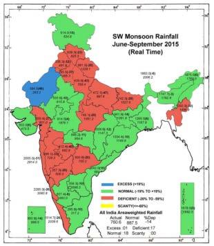
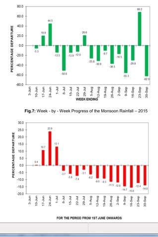
12 Intraseasonal extremes : Tropical Cyclones during monsoon season During the monsoon season, TCs generally form over the NIO during the onset and withdrawal phases. TC formation is minimum during the main monsoon months of July & August. During 2015, CS Komen formed on 26 th July. Last such TC formation during the month of July was in 1989 (after 35 years). Observed Track and forecast track based on 0600 UTC of 30 th July 2015
 (V.")
13 Intraseasonal extremes (LPS) and MJO MJO in phase 2-4 favourable for cyclogenesis over the NIO. (Mohapatra and Adhikary 2011) (V. Krishnamurthy and Ajayamohan 2010)
")

14 Intraseasonal extremes (LPS) and El Nino July 2003 July 2002

15
 Mean % of Heavy rainfall days days Mean % of Very heavy")
16 Indian Southwest Monsoon (June to September) JJAS mean rainfall (cm) Mean % of Heavy rainfall days days Mean % of Very heavy rainfall
17 Goswami et al, 2006 Pattanaik and Rajeevan (2010) Met. Appl. Rajeevan et al., 2006
18 Intraseasonal Extremes : Heavy Spells Heavy spell leads to flash floods, especially in urban areas Time of occurrence of rainfall during the day (>0 and >30 mm) Ray Et al, 2015 (Current Science)


 DWR Chennai 24-hr")

19 Existing Rainfall monitoring system and need Enhanced observational network (both direct and remotely sensed) alongwith merged dataset for monitoring every hourly Need for Meso network (1AWS/4 sq. km) DWR Chennai 24-hr rainfall, / 0830 hrs IST 675 AWS 24-hr accumulated precipitation as on 0830 hrs IST 02-Dec ARG

20 Monitoring of Intraseasonal Extremes There is need for augmentation of observational network in land, Ocean and atmosphere

21 Scales of Weather systems and Monitoring Requirement Too hard for the forecaster Atmospheric Scales Micro mm - cm Turbulent m km Convective 100 m 5 km Vortex km Environment ,000 km Cyc Bndy Lyr Cloud Phys Upper levels Dry Air Intrusion Genesis Rapid Int Eye Mix Extra Trop Ocean Enviro
22 Future Requirements : Observation Need for enhanced space based observations over data sparse regions through deployment of: INSAT-3D (R) with Rapid scan facility (Advanced base line Imager) like Himawari array of Polar orbiting satellites (IEO and LEO) for high resolution data Geostationary satellite with microwave payload Scatterometry based satellite Multi-satellite derived wind Augmentation of satellite based marine observations GPS RO observations and networking with other global satellites GPM/Lightening detection/smos/lidar Increase in accuracy of vertical profiles High resolution soil moisture, evapotranspiration measurements

23 Prediction of Dry Spells and wet spells: Met sub-division level forecasts for 2 weeks (IMD) All India = -33.5% NE India = +17.2% NW India =-47.5% CE India= -59.7% SP India= -21.5% All India = -19.6% NE India = +23.8% NW India =-39.5% CE India= -30.2% SP India= -28.9%


24 Pentad wise rainfall predicted by IITM (CFSv2 and GFS_bc) Forecast for 4 pentads based on 19 th August, 2015 IC
25 Numerical Weather Prediction (NWP) Modeling : Backbone for Early Warnings Ensemble Pred. Tools 120 h 96 h 72 h 48 h 24 h Multi-model ensemble, Single Model Ensemble, Grand Global Ensemble Global Models Regional Models Nowcasting Tools Global models Regional models Nowcasting Warnings Activities
26 Trend in heavy rainfall warning ( )
27 Heavy Rainfall (Phailin over Bay of Bengal) Observed rainfall 24 hr forecast for hvy rainfall or higher and no heavy rainfall Total 24 hr forecast for extremely heavy rainfall & no extremely heavy rainfall YES NO YES NO YES NO Total POD FAR MR C-NON CSI BIAS Occ PC (%) TSS HSS Total
28 SI. No. Basin Name QPF: A Challenge (Phailin) 24 hr QPF issued at 0300 UTC of hr QPF issued at 0300 UTC of hr QPF issued at 0300 UTC of Fcst Realize d Fcst Realiz ed Fcst Realized 1 Subrnarekha > Burhabalang Baitarani Upp. Brahmani > Low.Brahmani Upp. Mahanadi > Low. Mahanadi > Rusikulya > Vansadhara >


29 Local, DISTRICT and catchment level R/F FORECAST District level forecast issued for 5 days with warning for 3 days Example : On 01/12/2015 Extremely heavy rainfall warning for three districts viz., Chennai, Tiruvallur and Kancheepuram districts was issued for the next day. 24-hr forecast based on /0000 UTC valid for /0000 UTC
30 (i) Gaps in understanding active-break spells and their transitions, (ii) characteristics like genesis, intensification and movement of transient monsoon disturbances, (iii) meso-scale nature of heavy rainfall in large scale synoptic settings (iv) contribution of intra-seasonal variation to interannual variation (v) Role of large scale processes like (a) (b) (c) El Nino and Southern Oscillation, Madden Julian Oscillation and Indian Ocean dipole in the intraseasonal variation of monsoon circulation, characteristics of monsoon disturbances and large scale heavy rainfall. (vi) Cloud scale processes 16 Jan,
31 Gaps in prediction There have been significant improvements both in the modelling components (Atmospheric GCM and meso-scale models) Improvement in the assimilations of non-conventional data Improvement of short to medium range prediction of monsoon circulation and rainfall, forecasting of location specific heavy rainfall spell and dry spells is the main challenging area in medium and extended range time scale. Data assimilation is still challenging, especially remotely sensed satellite and radar data 16 Jan,
32 Challenges and Opportunity Monsoon Mission Field Experiments : CTCZ, CAIPEX, FDP-STORM, FDP-Cyclone Forecasting Experiment : SWFDP Modeling : Dynamical (GFS, UM, CFS V2, EPS, MME) Collaboration
33 Challenges and Opportunities: Early Warning System Initial conditions (Observations) Runs of different Models, Meteorological Hydrological Coastal inundation Model runs Numerical forecasts Meteorological Observation Digital Terrain Data Forecaster, Control Room, DSS, SOP, Vulnerability Assessment End forecast and warning (Impact based) Hydrological Observations Land surface processes Data Action Decision makers, Public,Media Redundant Communication system

34
KUALA LUMPUR MONSOON ACTIVITY CENT
 T KUALA LUMPUR MONSOON ACTIVITY CENT 2 ALAYSIAN METEOROLOGICAL http://www.met.gov.my DEPARTMENT MINISTRY OF SCIENCE. TECHNOLOGY AND INNOVATIO Introduction Atmospheric and oceanic conditions over the tropical
UPDATE OF REGIONAL WEATHER AND SMOKE HAZE (December 2017)
") UPDATE OF REGIONAL WEATHER AND SMOKE HAZE (December 2017) 1. Review of Regional Weather Conditions for November 2017 1.1 In November 2017, Southeast Asia experienced inter-monsoon conditions in the first
UPDATE OF REGIONAL WEATHER AND SMOKE HAZE (December 2017) 1. Review of Regional Weather Conditions for November 2017 1.1 In November 2017, Southeast Asia experienced inter-monsoon conditions in the first
Seasonal Climate Outlook for South Asia (June to September) Issued in May 2014
 Issued in May 2014") Ministry of Earth Sciences Earth System Science Organization India Meteorological Department WMO Regional Climate Centre (Demonstration Phase) Pune, India Seasonal Climate Outlook for South Asia (June
Ministry of Earth Sciences Earth System Science Organization India Meteorological Department WMO Regional Climate Centre (Demonstration Phase) Pune, India Seasonal Climate Outlook for South Asia (June
Current status and prospects of Extended range prediction of Indian summer monsoon using CFS model
 Current status and prospects of Extended range prediction of Indian summer monsoon using CFS model Dr. A. K. Sahai Indian Institute of Tropical Meteorology, Pune 411 008, INDIA E-mail: sahai@tropmet.res.in
11/19/14. Chapter 11: Hurricanes. The Atmosphere: An Introduction to Meteorology, 12 th. Lutgens Tarbuck
 Chapter 11: Hurricanes The Atmosphere: An Introduction to Meteorology, 12 th Lutgens Tarbuck Lectures by: Heather Gallacher, Cleveland State University! Hurricanes: " Hurricanes are intense centers of
Issued by the: Climate Services Division Fiji Meteorological Service Nadi Airport. 27 October 2010 GENERAL STATEMENT
 Fiji Meteorological Service (FMS) Tropical Cyclone Guidance for Season 2010/11 for the Fiji and the Southwest Pacific RSMC Region 160E to 120W Equator to 25 South Issued by the: Climate Services Division
UPDATE OF REGIONAL WEATHER AND SMOKE HAZE (May 2017)
") UPDATE OF REGIONAL WEATHER AND SMOKE HAZE (May 2017) 1. Review of Regional Weather Conditions in April 2017 1.1 Inter monsoon conditions, characterised by afternoon showers and winds that are generally
UPDATE OF REGIONAL WEATHER AND SMOKE HAZE (May 2017) 1. Review of Regional Weather Conditions in April 2017 1.1 Inter monsoon conditions, characterised by afternoon showers and winds that are generally
UPDATE OF REGIONAL WEATHER AND SMOKE HAZE (September 2017)
") UPDATE OF REGIONAL WEATHER AND SMOKE HAZE (September 2017) 1. Review of Regional Weather Conditions in August 2017 1.1 Southwest Monsoon conditions continued to prevail in the region in August 2017. The
UPDATE OF REGIONAL WEATHER AND SMOKE HAZE (September 2017) 1. Review of Regional Weather Conditions in August 2017 1.1 Southwest Monsoon conditions continued to prevail in the region in August 2017. The
Long Range Forecasts of 2015 SW and NE Monsoons and its Verification D. S. Pai Climate Division, IMD, Pune
 Long Range Forecasts of 2015 SW and NE Monsoons and its Verification D. S. Pai Climate Division, IMD, Pune Other Contributors: Soma Sen Roy, O. P. Sreejith, Kailas, Madhuri, Pallavi, Mahendra and Jasmine
Dynamical Seasonal Monsoon Forecasting at IITM
 Dynamical Seasonal Monsoon Forecasting at IITM H. S. Chaudhari, S. K. Saha, A. Hazra, S.Pokhrel, S. A. Rao, A. K. Sahai, R. Krishnan & Seasonal Prediction and Extended Range Prediction Group Indian Institute
ROLE OF INDIA METEOROLOGICAL DEPARTMENT IN MANAGEMENT OF METEOROLOGICAL HAZARDS IN INDIA M MOHAPATRA
 ROLE OF INDIA METEOROLOGICAL DEPARTMENT IN MANAGEMENT OF METEOROLOGICAL HAZARDS IN INDIA M MOHAPATRA INDIA METEOROLOGICAL DEPARTMENT NEW DELHI-110003 mohapatraimd@gmail.com Introduction Presentation layout
Tropical Cyclone Genesis: What we know, and what we don t!
 Tropical Cyclone Genesis: What we know, and what we don t! Allison Wing! NSF Postdoctoral Research Fellow! Lamont-Doherty Earth Observatory! Columbia University! Overview! Climatology! What We Know! Theories!
Evidence for Weakening of Indian Summer Monsoon and SA CORDEX Results from RegCM
 Evidence for Weakening of Indian Summer Monsoon and SA CORDEX Results from RegCM S K Dash Centre for Atmospheric Sciences Indian Institute of Technology Delhi Based on a paper entitled Projected Seasonal
Characteristics of Sudden Changes in Tropical Cyclone Tracks over North Indian Ocean. M. Mohapatra and B. K. Bandyopadhyay
 Characteristics of Sudden Changes in Tropical Cyclone Tracks over North Indian Ocean M. Mohapatra and B. K. Bandyopadhyay INDIA METEOROLOGICAL DEPARTMENT MAUSAM BHAVAN, LODI ROAD, NEW DELHI 110003 mohapatraimd@gmail.com
Understanding the Global Distribution of Monsoon Depressions
 DISTRIBUTION STATEMENT A. Approved for public release; distribution is unlimited. Understanding the Global Distribution of Monsoon Depressions William R. Boos PO Box 208109 New Haven, CT 06520 phone: (203)
Assessing Land Surface Albedo Bias in Models of Tropical Climate
 DISTRIBUTION STATEMENT A. Approved for public release; distribution is unlimited. Assessing Land Surface Albedo Bias in Models of Tropical Climate William R. Boos (PI) Yale University PO Box 208109 New
ANNUAL CLIMATE REPORT 2016 SRI LANKA
 ANNUAL CLIMATE REPORT 2016 SRI LANKA Foundation for Environment, Climate and Technology C/o Mahaweli Authority of Sri Lanka, Digana Village, Rajawella, Kandy, KY 20180, Sri Lanka Citation Lokuhetti, R.,
3. HYDROMETEROLOGY. 3.1 Introduction. 3.2 Hydro-meteorological Aspect. 3.3 Rain Gauge Stations
 3. HYDROMETEROLOGY 3.1 Introduction Hydrometeorology is a branch of meteorology and hydrology that studies the transfer of water and energy between the land surface and the lower atmosphere. Detailed hydrological
Charles Jones ICESS University of California, Santa Barbara CA Outline
 The Influence of Tropical Variations on Wintertime Precipitation in California: Pineapple express, Extreme rainfall Events and Long-range Statistical Forecasts Charles Jones ICESS University of California,
Climate Prediction Center Research Interests/Needs
 Climate Prediction Center Research Interests/Needs 1 Outline Operational Prediction Branch research needs Operational Monitoring Branch research needs New experimental products at CPC Background on CPC
MAURITIUS METEOROLOGICAL SERVICES
 MAURITIUS METEOROLOGICAL SERVICES CLIMATE DECEMBER 2018 Introduction December 2018 was warm and wet. The mean monthly rainfall recorded islandwise was 261 mm which is 151 % of the normal. ENSO conditions
Tropical Storm List
 Tropical Storm Email List http://tstorms.org/ tropical-storms@tstorms.org Tropical-Storms is a mailing list only for those who are professionally active in either the research or forecasting of tropical
MAURITIUS METEOROLOGICAL SERVICES
 MAURITIUS METEOROLOGICAL SERVICES CLIMATE DECEMBER 2018 Introduction December 2018 was warm and wet. The mean monthly rainfall recorded islandwise was 261 mm which is 151 % of the normal. ENSO conditions
ENSO Cycle: Recent Evolution, Current Status and Predictions. Update prepared by Climate Prediction Center / NCEP 11 November 2013
 ENSO Cycle: Recent Evolution, Current Status and Predictions Update prepared by Climate Prediction Center / NCEP 11 November 2013 Outline Overview Recent Evolution and Current Conditions Oceanic Niño Index
ENSO Cycle: Recent Evolution, Current Status and Predictions. Update prepared by Climate Prediction Center / NCEP 23 April 2012
 ENSO Cycle: Recent Evolution, Current Status and Predictions Update prepared by Climate Prediction Center / NCEP 23 April 2012 Outline Overview Recent Evolution and Current Conditions Oceanic Niño Index
Understanding the Microphysical Properties of Developing Cloud Clusters during TCS-08
 DISTRIBUTION STATEMENT A: Approved for public release; distribution is unlimited. Understanding the Microphysical Properties of Developing Cloud Clusters during TCS-08 PI: Elizabeth A. Ritchie Department
ENSO: Recent Evolution, Current Status and Predictions. Update prepared by: Climate Prediction Center / NCEP 9 November 2015
 ENSO: Recent Evolution, Current Status and Predictions Update prepared by: Climate Prediction Center / NCEP 9 November 2015 Outline Summary Recent Evolution and Current Conditions Oceanic Niño Index (ONI)
An upper to mid level circulation (Low) in the NW Caribbean is
 in the NW Caribbean is") WEEKLY WEATHER OUTLOOK BELIZE, CENTRAL AMERICA PERIOD: Monday-Monday, Oct. 1 October 8, 2012 DATE ISSUED: Monday, Oct 1, 2012 6:00 am RFrutos EcoSolutions & Services SYNOPSIS: An upper to mid level circulation
WEEKLY WEATHER OUTLOOK BELIZE, CENTRAL AMERICA PERIOD: Monday-Monday, Oct. 1 October 8, 2012 DATE ISSUED: Monday, Oct 1, 2012 6:00 am RFrutos EcoSolutions & Services SYNOPSIS: An upper to mid level circulation
The Properties of Convective Clouds Over the Western Pacific and Their Relationship to the Environment of Tropical Cyclones
 The Properties of Convective Clouds Over the Western Pacific and Their Relationship to the Environment of Tropical Cyclones Principal Investigator: Dr. Zhaoxia Pu Department of Meteorology, University
Theoretical and Modeling Issues Related to ISO/MJO
 Theoretical and Modeling Issues Related to ISO/MJO Tim Li Department of Meteorology and IPRC University of Hawaii DYNAMO workshop, April 13-14, Boulder, Colorado 1. MJO Initiation issue: Role of air- sea
Satellite derived precipitation estimates over Indian region during southwest monsoons
 J. Ind. Geophys. Union ( January 2013 ) Vol.17, No.1, pp. 65-74 Satellite derived precipitation estimates over Indian region during southwest monsoons Harvir Singh 1,* and O.P. Singh 2 1 National Centre
Update on SCOPE-Nowcasting Pilot Project Real Time Ocean Products Suman Goyal Scientist-E
 Update on SCOPE-Nowcasting Pilot Project Real Time Ocean Products Suman Goyal Scientist-E 19-22 Nov 2013 SCOPE-Nowcasting-1 Agenda Item 5 Pilot Projects Overview Users /Clients User requirements Product
ENSO Cycle: Recent Evolution, Current Status and Predictions. Update prepared by Climate Prediction Center / NCEP 5 August 2013
 ENSO Cycle: Recent Evolution, Current Status and Predictions Update prepared by Climate Prediction Center / NCEP 5 August 2013 Outline Overview Recent Evolution and Current Conditions Oceanic Niño Index
ENSO Cycle: Recent Evolution, Current Status and Predictions. Update prepared by Climate Prediction Center / NCEP 15 July 2013
 ENSO Cycle: Recent Evolution, Current Status and Predictions Update prepared by Climate Prediction Center / NCEP 15 July 2013 Outline Overview Recent Evolution and Current Conditions Oceanic Niño Index
Regional Flash Flood Guidance and Early Warning System
 WMO Training for Trainers Workshop on Integrated approach to flash flood and flood risk management 24-28 October 2010 Kathmandu, Nepal Regional Flash Flood Guidance and Early Warning System Dr. W. E. Grabs
Thai Meteorological Department, Ministry of Digital Economy and Society
 Thai Meteorological Department, Ministry of Digital Economy and Society Three-month Climate Outlook For November 2017 January 2018 Issued on 31 October 2017 -----------------------------------------------------------------------------------------------------------------------------
Predicting South Asian Monsoon through Spring Predictability Barrier
 Predicting South Asian Monsoon through Spring Predictability Barrier Suryachandra A. Rao Associate Mission Director, Monsoon Mission Project Director, High Performance Computing Indian Institute of Tropical
A High Resolution Daily Gridded Rainfall Data Set ( ) for Mesoscale Meteorological Studies
 for Mesoscale Meteorological Studies") National Climate Centre Research Report No: 9/2008 A High Resolution Daily Gridded Rainfall Data Set (1971-2005) for Mesoscale Meteorological Studies M. Rajeevan and Jyoti Bhate National Climate Centre
National Climate Centre Research Report No: 9/2008 A High Resolution Daily Gridded Rainfall Data Set (1971-2005) for Mesoscale Meteorological Studies M. Rajeevan and Jyoti Bhate National Climate Centre
Background to observing system assessment for the Indian Ocean
 Background to observing system assessment for the Indian Ocean Indian Ocean Modeling Workshop IPRC, Honolulu, November 2004 Gary Meyers Unique geography and physics (a unique heat engine) Unique social,
ENSO: Recent Evolution, Current Status and Predictions. Update prepared by: Climate Prediction Center / NCEP 30 October 2017
 ENSO: Recent Evolution, Current Status and Predictions Update prepared by: Climate Prediction Center / NCEP 30 October 2017 Outline Summary Recent Evolution and Current Conditions Oceanic Niño Index (ONI)
Long Range Forecast Update for 2014 Southwest Monsoon Rainfall
 Earth System Science Organization (ESSO) Ministry of Earth Sciences (MoES) India Meteorological Department PRESS RELEASE New Delhi, 9 June 2014 Long Update for 2014 Southwest Monsoon Rainfall HIGHLIGHTS
H2020-TWINN Guest lecture. 9May2018 Vienna, Austria
 H2020-TWINN-2015 Meteorological data: sources, representativeness & use + Brčko Ao. Prof. Branislava Lalic Guest lecture 9May2018 Vienna, Austria Institution: Faculty of Agriculture, University of Novi
Examination of Tropical Cyclogenesis using the High Temporal and Spatial Resolution JRA-25 Dataset
 Examination of Tropical Cyclogenesis using the High Temporal and Spatial Resolution JRA-25 Dataset Masato Sugi Forecast Research Department, Meteorological Research Institute, Japan Correspondence: msugi@mri-jma.go.jp
Seasonal Climate Watch February to June 2018
 Seasonal Climate Watch February to June 2018 Date issued: Jan 26, 2018 1. Overview The El Niño-Southern Oscillation (ENSO) is expected to remain in a weak La Niña phase through to early autumn (Feb-Mar-Apr).
The 2009 Hurricane Season Overview
 The 2009 Hurricane Season Overview Jae-Kyung Schemm Gerry Bell Climate Prediction Center NOAA/ NWS/ NCEP 1 Overview outline 1. Current status for the Atlantic, Eastern Pacific and Western Pacific basins
ENSO Cycle: Recent Evolution, Current Status and Predictions. Update prepared by Climate Prediction Center / NCEP 25 February 2013
 ENSO Cycle: Recent Evolution, Current Status and Predictions Update prepared by Climate Prediction Center / NCEP 25 February 2013 Outline Overview Recent Evolution and Current Conditions Oceanic Niño Index
Hurricanes. April 14, 2009
 Tropical Weather & Hurricanes Chapter 15 April 14, 2009 Tropical meteorology Tropics characterized by seasonal wet and drier periods- wet when sun is nearly overhead at noon and inter-tropical convergence
Government of Sultanate of Oman Public Authority of Civil Aviation Directorate General of Meteorology. National Report To
 Government of Sultanate of Oman Public Authority of Civil Aviation Directorate General of Meteorology National Report To Panel on Tropical Cyclones in the Bay of Bengal And Arabian Sea 43rd Session, India
UPDATE OF REGIONAL WEATHER AND SMOKE HAZE (February 2018)
") UPDATE OF REGIONAL WEATHER AND SMOKE HAZE (February 2018) 1. Review of Regional Weather Conditions for January 2018 1.1 The prevailing Northeast monsoon conditions over Southeast Asia strengthened in January
UPDATE OF REGIONAL WEATHER AND SMOKE HAZE (February 2018) 1. Review of Regional Weather Conditions for January 2018 1.1 The prevailing Northeast monsoon conditions over Southeast Asia strengthened in January
Air-Sea Interaction Study in the Tropics by JAMSTEC
 Air-Sea Interaction Study in the Tropics by JAMSTEC History : Major Activities related to Air-Sea Interaction Study 1987 JENEX-87 (Japanese El Niño Experiment - 87) * This was the first trial for El Niño
Key Finding: Long Term Trend During 2014: Rain in Indian Tradition Measuring Rain
 Chapter 34 RAINFALL Key Finding: Long Term Trend Despite of theories suggesting increase in rainfall in Asian Region due to global warming, no significant trend has been observed at all India level (confirmed
An overview of Wet Season Forecasting in the Northern Territory
 TWP-ICE Meeting November 2004 An overview of Wet Season Forecasting in the Northern Territory Lori Chappel Northern Territory Regional Forecasting Centre Australian Government Bureau of Meteorology Day
Application of Radio Occultation Data in Analyses and Forecasts of Tropical Cyclones Using an Ensemble Assimilation System
 Application of Radio Occultation Data in Analyses and Forecasts of Tropical Cyclones Using an Assimilation System Hui Liu, Jeff Anderson, and Bill Kuo NCAR Acknowledgment: C. Snyder, Y. Chen, T. Hoar,
Haiti and Dominican Republic Flash Flood Initial Planning Meeting
 Dr Rochelle Graham Climate Scientist Haiti and Dominican Republic Flash Flood Initial Planning Meeting September 7 th to 9 th, 2016 Hydrologic Research Center http://www.hrcwater.org Haiti and Dominican
(April 7, 2010, Wednesday) Tropical Storms & Hurricanes Part 2
 Tropical Storms & Hurricanes Part 2") Lecture #17 (April 7, 2010, Wednesday) Tropical Storms & Hurricanes Part 2 Hurricane Katrina August 2005 All tropical cyclone tracks (1945-2006). Hurricane Formation While moving westward, tropical disturbances
Lecture #17 (April 7, 2010, Wednesday) Tropical Storms & Hurricanes Part 2 Hurricane Katrina August 2005 All tropical cyclone tracks (1945-2006). Hurricane Formation While moving westward, tropical disturbances
ENSO Cycle: Recent Evolution, Current Status and Predictions. Update prepared by Climate Prediction Center / NCEP 24 September 2012
 ENSO Cycle: Recent Evolution, Current Status and Predictions Update prepared by Climate Prediction Center / NCEP 24 September 2012 Outline Overview Recent Evolution and Current Conditions Oceanic Niño
DETECTION AND FORECASTING - THE CZECH EXPERIENCE
 1 STORM RAINFALL DETECTION AND FORECASTING - THE CZECH EXPERIENCE J. Danhelka * Czech Hydrometeorological Institute, Prague, Czech Republic Abstract Contribution presents the state of the art of operational
Trends in the Character of Hurricanes and their Impact on Heavy Rainfall across the Carolinas
 Trends in the Character of Hurricanes and their Impact on Heavy Rainfall across the Carolinas Chip Konrad Carolina Integrated Science and Assessments (CISA) The Southeast Regional Climate Center Department
Convective-scale NWP for Singapore
 Convective-scale NWP for Singapore Hans Huang and the weather modelling and prediction section MSS, Singapore Dale Barker and the SINGV team Met Office, Exeter, UK ECMWF Symposium on Dynamical Meteorology
The ECMWF Extended range forecasts
 The ECMWF Extended range forecasts Laura.Ferranti@ecmwf.int ECMWF, Reading, U.K. Slide 1 TC January 2014 Slide 1 The operational forecasting system l High resolution forecast: twice per day 16 km 91-level,
Introduction of climate monitoring and analysis products for one-month forecast
 Introduction of climate monitoring and analysis products for one-month forecast TCC Training Seminar on One-month Forecast on 13 November 2018 10:30 11:00 1 Typical flow of making one-month forecast Observed
Early Warning System and Role of IMD. Manmohan Singh Meteorological Centre Shimla
 Early Warning System and Role of IMD Manmohan Singh Meteorological Centre Shimla India a land with a unique climatic regime Two monsoon seasons (southwest & northeast monsoons) Two cyclone seasons (pre
TROPICAL-EXTRATROPICAL INTERACTIONS
 Notes of the tutorial lectures for the Natural Sciences part by Alice Grimm Fourth lecture TROPICAL-EXTRATROPICAL INTERACTIONS Anomalous tropical SST Anomalous convection Anomalous latent heat source Anomalous
Kevin E Trenberth NCAR
 Attribution of Recent Increases in Atlantic Hurricane Activity Kevin E Trenberth NCAR Issues for detection and attribution of changes in hurricanes What has happened? How good is the observational record?
Chapter 4 Inter-Annual and Long-Term Variability
 Chapter 4 Inter-Annual and Long-Term Variability 4.1 General Rainfa\\ is the most imllortant weather element for India, a trollica\ country. Agriculture, hydro-electric power, industry and the economy
Tropical Cyclone Formation/Structure/Motion Studies
 Tropical Cyclone Formation/Structure/Motion Studies Patrick A. Harr Department of Meteorology Naval Postgraduate School Monterey, CA 93943-5114 phone: (831) 656-3787 fax: (831) 656-3061 email: paharr@nps.edu
Understanding the Global Distribution of Monsoon Depressions
 DISTRIBUTION STATEMENT A. Approved for public release; distribution is unlimited. Understanding the Global Distribution of Monsoon Depressions William R. Boos PO Box 208109 New Haven, CT 06520 phone: (203)
Probabilistic predictions of monsoon rainfall with the ECMWF Monthly and Seasonal Forecast Systems
 Probabilistic predictions of monsoon rainfall with the ECMWF Monthly and Seasonal Forecast Systems Franco Molteni, Frederic Vitart, Tim Stockdale, Laura Ferranti, Magdalena Balmaseda European Centre for
NOAA 2015 Updated Atlantic Hurricane Season Outlook
 NOAA 2015 Updated Atlantic Hurricane Season Outlook Dr. Gerry Bell Lead Seasonal Forecaster Climate Prediction Center/ NOAA/ NWS Collaboration With National Hurricane Center/ NOAA/ NWS Hurricane Research
1. Introduction. 2. Verification of the 2010 forecasts. Research Brief 2011/ February 2011
 Research Brief 2011/01 Verification of Forecasts of Tropical Cyclone Activity over the Western North Pacific and Number of Tropical Cyclones Making Landfall in South China and the Korea and Japan region
CURRENT STATUS OF MONSOON Main Meteorological conditions of the last week (27August to 2 September)
") CURRENT STATUS OF MONSOON 2009 Main Meteorological conditions of the last week (27August to 2 September) Last week s low pressure area over Orissa and neighbourhood moved west-northwestwards across central
CURRENT STATUS OF MONSOON 2009 Main Meteorological conditions of the last week (27August to 2 September) Last week s low pressure area over Orissa and neighbourhood moved west-northwestwards across central
5 Atmospheric Disturbances 7 1.Cyclones- tropical and temperate and associated weather conditions. 2.Anticyclones and associated weather conditions.
 5 Atmospheric Disturbances 7 1.Cyclones- tropical and temperate and associated weather conditions. 2.Anticyclones and associated weather conditions. atmospheric disturbances (weather systems) that are
What is the Madden-Julian Oscillation (MJO)?
?") What is the Madden-Julian Oscillation (MJO)? Planetary scale, 30 90 day oscillation in zonal wind, precipitation, surface pressure, humidity, etc., that propagates slowly eastward Wavelength = 12,000 20,000
What is the Madden-Julian Oscillation (MJO)? Planetary scale, 30 90 day oscillation in zonal wind, precipitation, surface pressure, humidity, etc., that propagates slowly eastward Wavelength = 12,000 20,000
CHAPTER 1 INTRODUCTION
 1 CHAPTER 1 INTRODUCTION 1.1 GENERAL Precipitation is the primary input to a watershed system. Hydrologic analysis cannot be performed with confidence until the precipitation input is adequately measured
International Desks: African Training Desk and Projects
 The Climate Prediction Center International Desks: African Training Desk and Projects Wassila M. Thiaw Team Leader Climate Prediction Center National Centers for Environmental Predictions 1 African Desk
Topic 5.2: Seasonal Forecasts
 Topic 5.2: Seasonal Forecasts Contributions from: Maritza Ballester, Eric Blake, Suzanna Camargo, Joanne Camp, Johnny Chan, Phil Klotzbach, Yuriy Kuleshov, Mark Saunders, O. P. Singh, Gabriel Vecchi and
EVALUATION OF BROAD SCALE VERTICAL CIRCULATION AND THERMAL INDICES IN RELATION TO THE ONSET OF INDIAN SUMMER MONSOON
 INTERNATIONAL JOURNAL OF CLIMATOLOGY Int. J. Climatol. 22: 649 661 (2002) Published online in Wiley InterScience (www.interscience.wiley.com). DOI: 10.1002/joc.742 EVALUATION OF BROAD SCALE VERTICAL CIRCULATION
Advanced Hydrology. (Web course)
") Advanced Hydrology (Web course) Subhankar Karmakar Assistant Professor Centre for Environmental Science and Engineering (CESE) Indian Institute of Technology Bombay Powai, Mumbai 400 076 Email: skarmakar@iitb.ac.in
Advanced Hydrology (Web course) Subhankar Karmakar Assistant Professor Centre for Environmental Science and Engineering (CESE) Indian Institute of Technology Bombay Powai, Mumbai 400 076 Email: skarmakar@iitb.ac.in
David W. Reynolds * National Weather Service WFO San Francisco Bay Area Monterey, CA
 3.2 THE MADDEN JULIAN OSCILLATION: ITS POTENTIAL FOR WEEK TWO FLOOD OUTLOOKS AND RESERVOIR MANAGEMENT DECISIONS IN CALIFORNIA David W. Reynolds * National Weather Service WFO San Francisco Bay Area Monterey,
Use of the Combined Pacific Variability Mode for Climate Prediction in North America
 Use of the Combined Pacific Variability Mode for Climate Prediction in North America Christopher L. Castro,, Stephen Bieda III, and Francina Dominguez University of Arizona Regional Climate Forum for Northwest
Climate Change and Predictability of the Indian Summer Monsoon
 Climate Change and Predictability of the Indian Summer Monsoon B. N. Goswami (goswami@tropmet.res.in) Indian Institute of Tropical Meteorology, Pune Annual mean Temp. over India 1875-2004 Kothawale, Roopakum
Variability of West African Weather Systems. Chris Thorncroft Department of Atmospheric and Environmental Sciences University at Albany
 Variability of West African Weather Systems Chris Thorncroft Department of Atmospheric and Environmental Sciences University at Albany Variability of West African Weather Systems (1) Convectively Coupled
Vertical wind shear in relation to frequency of Monsoon Depressions and Tropical Cyclones of Indian Seas
 Vertical wind shear in relation to frequency of Monsoon Depressions and Tropical Cyclones of Indian Seas Prince K. Xavier and P.V. Joseph Department of Atmospheric Sciences Cochin University of Science
By: J Malherbe, R Kuschke
 2015-10-27 By: J Malherbe, R Kuschke Contents Summary...2 Overview of expected conditions over South Africa during the next few days...3 Significant weather events (27 October 2 November)...3 Conditions
Flash Flood Guidance: SARFFG modeling system
 Flash Flood Guidance: SARFFG modeling system Eugene Poolman Chief Forecasting: Disaster Risk Reduction RSMC Pretoria FCAST-PRES-20141021-001.1 Flash Floods vs. River Floods River floods are caused by heavy
Evolution of Tropical Cyclone Characteristics
 Evolution of Tropical Cyclone Characteristics Patrick A. Harr Department of Meteorology Naval Postgraduate School Monterey, CA 93943-5114 Telephone : (831) 656-3787 FAX: (831) 656-3061 email: paharr@nps.navy.mil
The Abnormal Indian Summer Monsoon of 2002: JRA25 Reanalysis
 The Abnormal Indian Summer Monsoon of 2002: JRA25 Reanalysis D. Rajan 1,2, T. Koike 2, J. Matsumoto 2 1 NCMRWF, Ministry of Earth Sciences, India 2 CEOP Lab, University of Tokyo, Japan Correspondence:
Prospects for subseasonal forecast of Tropical Cyclone statistics with the CFS
 Prospects for subseasonal forecast of Tropical Cyclone statistics with the CFS Augustin Vintzileos (1)(3), Tim Marchok (2), Hua-Lu Pan (3) and Stephen J. Lord (1) SAIC (2) GFDL (3) EMC/NCEP/NOAA During
Forecasting at the interface between weather and climate: beyond the RMM-index
 Forecasting at the interface between weather and climate: beyond the RMM-index Augustin Vintzileos University of Maryland ESSIC/CICS-MD Jon Gottschalck NOAA/NCEP/CPC Outline The Global Tropics Hazards
Heavy Rainfall Event of June 2013
 Heavy Rainfall Event of 10-11 June 2013 By Richard H. Grumm National Weather Service State College, PA 1. Overview A 500 hpa short-wave moved over the eastern United States (Fig. 1) brought a surge of
p = ρrt p = ρr d = T( q v ) dp dz = ρg
 dp dz = ρg") Chapter 1: Properties of the Atmosphere What are the major chemical components of the atmosphere? Atmospheric Layers and their major characteristics: Troposphere, Stratosphere Mesosphere, Thermosphere
Chapter 1: Properties of the Atmosphere What are the major chemical components of the atmosphere? Atmospheric Layers and their major characteristics: Troposphere, Stratosphere Mesosphere, Thermosphere
CPTEC and NCEP Model Forecast Drift and South America during the Southern Hemisphere Summer
 CPTEC and NCEP Model Forecast Drift and South America during the Southern Hemisphere Summer José Antonio Aravéquia 1 Pedro L. Silva Dias 2 (1) Center for Weather Forecasting and Climate Research National
Verification of the Seasonal Forecast for the 2005/06 Winter
 Verification of the Seasonal Forecast for the 2005/06 Winter Shingo Yamada Tokyo Climate Center Japan Meteorological Agency 2006/11/02 7 th Joint Meeting on EAWM Contents 1. Verification of the Seasonal
Outline of 4 Lectures
 Outline of 4 Lectures 1. Sept. 17, 2008: TC best track definition and datasets, global distribution of TCs; Review of history of meteorological satellites, introducing different orbits, scanning patterns,
Challenges and Advances related to TC Rainfall Forecast. WOO Wang-chun Hong Kong Observatory IWTCLP-III, Jeju, Korea 10 Dec 2014
 Challenges and Advances related to TC Rainfall Forecast WOO Wang-chun Hong Kong Observatory IWTCLP-III, Jeju, Korea 10 Dec 2014 Working Group Composition Member Wallace HOGSETT Affiliations Weather Analytics,
TROPICAL CYCLONE TC 03A FOR THE PERIOD 3 RD JUNE TO 10 TH JUNE, 1998
 TROPICAL CYCLONE TC 03A FOR THE PERIOD 3 RD JUNE TO 10 TH JUNE, 1998 Hazrat Mir, Abdul Rashid, Waqarul Wheed Khan. Introduction: This report gives the review of cyclonic storm formed over the East Arabian
S2S Monsoon Subseasonal Prediction Overview of sub-project and Research Report on Prediction of Active/Break Episodes of Australian Summer Monsoon
 S2S Monsoon Subseasonal Prediction Overview of sub-project and Research Report on Prediction of Active/Break Episodes of Australian Summer Monsoon www.cawcr.gov.au Harry Hendon Andrew Marshall Monsoons
WEEKLY WEATHER OUTLOOK BELIZE, CENTRAL AMERICA
 WEEKLY WEATHER OUTLOOK BELIZE, CENTRAL AMERICA PERIOD: Sunday, June 17 until Monday, June 25, 2012 DATE ISSUED: Sunday, June 17, 2012; 3:00 pm RFrutos EcoSolutions & Services SYNOPSIS: An upper level trough
Indiana County Flash Flood of 22 June 2017
 Indiana County Flash Flood of 22 June 2017 By Richard H. Grumm National Weather Service State College, PA 1. Overview Slow moving thunderstorms brought 3 to 4 inches of rainfall to Indiana County, PA during
Will a warmer world change Queensland s rainfall?
 Will a warmer world change Queensland s rainfall? Nicholas P. Klingaman National Centre for Atmospheric Science-Climate Walker Institute for Climate System Research University of Reading The Walker-QCCCE