Characteristics of Sudden Changes in Tropical Cyclone Tracks over North Indian Ocean. M. Mohapatra and B. K. Bandyopadhyay
|
|
|
- Janis Preston
- 5 years ago
- Views:
Transcription

1 Characteristics of Sudden Changes in Tropical Cyclone Tracks over North Indian Ocean M. Mohapatra and B. K. Bandyopadhyay INDIA METEOROLOGICAL DEPARTMENT MAUSAM BHAVAN, LODI ROAD, NEW DELHI
2 PRESENTATION LAYOUT Introduction Data and Methodology Results and Discussion Translation speed and Track Changes Convection and Track Changes Steering wind and Track Change MJO and Track Changes Conclusion

3 Most of the natural hazards are weather related WINTER (JAN FEB) WESTERN DISTURBANCES COLD WAVE, FOG PRE MONSOON (MAR MAY MONSOON (JUN SEP) POST MONSOON (OCT DEC) CYCLONIC DISTURBANCES HEAT WAVE THUNDER STORMS, SQUALLS HAIL STORM TORNADO SOUTHWEST MONSOON CIRCULATION MONSOON DISTURBANCES NORTHEAST MONSOON CYCLONIC DISTURBANCES
 of tropical storms/cyclones over each ocean basin (average")
4 Climatology of tropical storms and cyclones F. F. Roux, Roux, Average annual number ( ) of tropical storms/cyclones over each ocean basin (average around the globe : 84 TS / 44 TC) and average track of the disturbances

, Maximum No.")
5 Climatological Characteristics Out of 80 forming over the globe, five form over north Indian Ocean Ratio of TCs between Bay of Bengal and Arabian Sea 4:1 Year to year variation Quite large. Minimum No. of cyclones in a year One (1949), Maximum No.of cyclones in a year Ten (1893,1926,1930,1976)

6 Frequency of Cyclonic disturbances over north Indian Ocean during JAN FEB MAR APR MAY JUNE JULY AUG SEP OCT NOV DEC Depression Cyclonic Storms Severe cyclonic storms 68% of disturbances over Bay of Bengal have landfall over east coast c 30% of disturbances over Arabian Sea have landfall over west coast


7 TROPICAL CYCLONES over NIO as Disaster YEAR COUNTRIES DEATHS 1970 Bangladesh 500, India 300, China 300, Japan 250, Bangladesh 200, Bangladesh 175, Bangladesh 140, Myanmar 138, India 50, India 50, Bangladesh 40, Antilles(West Indies) 22, Bangladesh 19, India 10, Bangladesh 11, Bangladesh 11, Bangladesh 11, India 10, India 10, Cuba 7,196 NARGIS : An Example of recent devastating cyclone Cyclone not only causes loss of life and property on landfall, it i t also causes disaster in aviation and navigation sectors 1900 USA 6, Bangladesh 5, Japan 5, India 5,000
 and Tropical Cyclone Advisories for Aviation as per guidelines")
8 Regional Specialised Meteorological Centre (RSMC) Tropical Cyclone, New Delhi Monitoring and prediction of Cyclones over the North Indian Ocean Issue of Tropical weather outlook/ Cyclone Advisories to the WMO/ESCAP Panel Countries (Bangladesh, Myanmar, Thailand, Srilanka, Maldives, Oman and Pakistan) and Tropical Cyclone Advisories for Aviation as per guidelines of ICAO
9 Monitoring and Forecast Process Broad Classification of Observations Space B ased Geoststionary Satellites Polar Orbiting Satellites U pper Air Pilot Balloon R SR W Profiler Ground B ased RAD AR A ircraft Initial conditions (Observations) Surface A WS A RG SYN OP B UOYS A VIATION SHIPS Action Runs of different Models, Consecutive runs from the same model, Ensemble runs ("choosing the best member") Model Model runs Numerical Numerical forecasts forecasts Forecaster End forecast Decision maker Monitoring and Forecast Process of Tropical Cyclone
10 TC track forecasting methods i) Statistical Techniques ii) iii) i) Analogue ii) iii) Persistence Climatology iv) CLIPER, v) Chaos theory and Generic Algorithm method) Synoptic Techniques Empirical Techniques Satellite Techniques Techniques iv) Radar Techniques v) NWP Models Individual models (Global and regional) IMDGFS (382, 574), NCMRWF (254), ARP (MeteoFrance, ECMWF, JMA, UKMO, NCEP, WRF (IMD, IITD, IAF), HWRF (IMD), QLM MME (IMD) and MME based on Tropical Cyclone Module (TCM) EPS (Strike probability, Location specific probability vi) Operational (Consensus) forecast
11 TC intensity forecasting methods i) Statistical Techniques ii) iii) i) Analogue ii) iii) Persistence Climatology iv) CLIPER, Synoptic Techniques Empirical Techniques (as discussed in case of genesis) Satellite Techniques Techniques iv) Radar Techniques v) NWP Models Individual models (Global and regional) IMDGFS (382, 574), NCMRWF (254), ARP (MeteoFrance, ECMWF, JMA, UKMO, NCEP, WRF (IMD, IITD, IAF), HWRF (IMD), QLM Wind probability (To be developed) and risk Threat graphics (To be developed) vi) Dynamical Statistical Model (SCIP) Operational (Consensus) forecast
 Year 24 hr 27%, 48 hr 39% 72 hr 50% North Atlantic(NHC) 24hr 95km, 48hr 150 km 72hr 250 km NW Pacific(JMA) 24hr 113km, 48hr 208 km 72hr")
12 Track forecast error (km) Average ( ) 24 hr 130 km, 48 hr 262 km 72 hr 386 km Skill compared to CLIPER model Year Track forecast skill (%) (b) Track forecast skill (%) Year 24 hr 27%, 48 hr 39% 72 hr 50% North Atlantic(NHC) 24hr 95km, 48hr 150 km 72hr 250 km NW Pacific(JMA) 24hr 113km, 48hr 208 km 72hr 310 km
 Average")


13 Average direct position error (km) (a) Lead time of forecast (Hrs) Average skill (%) of track forecast Comparison of forecast error and skill of climatological/ straight moving and recurving TCs over NIO Lead time of forecast (Hrs)


14 Comparison of Cone of Uncertainty for climatological/ straight moving and recurving TCs
 (a)")
 of")
15 Percentage of forecasts within and outside the cone of uncertainty (COU) (a) Climatological/straigh t moving TCs (b) Recurving/looping TCs Lead period(hr) of forecast
16 Data and Methodology The sudden change in track may occur due to sudden change in direction of movement leading to recurvature of the TC, sudden increase in speed of movement and sudden decrease in speed in movement leading to quasistationarity of the TC. While sudden increase/decrease in speed of movement, especially near the coast caused not only the forecast difficult, but also put the TC disaster management into disarray. So all the three types of sudden changes in track, as mentioned above have, been considered in this study for detailed analysis.
17 Data and Method For the purpose of analysis, the classification of the intense lowpressure systems as adopted by India Meteorological department(imd)/ Regional Specialised Meteorol,ogical Centre (RSMC), New Delhi (IMD, 2003) has been considered Low pressure system Maximum sustained winds Low < 17 knots < 31 kmph Depression kts kmph Deep Depression kts kmph Cyclone kts kmph Severe Cyclone kts kmph Very Severe Cyclone kts kmph Super Cyclone 120 kts & above 222 kmph & above
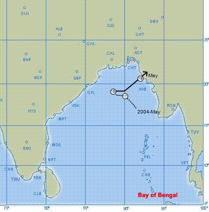
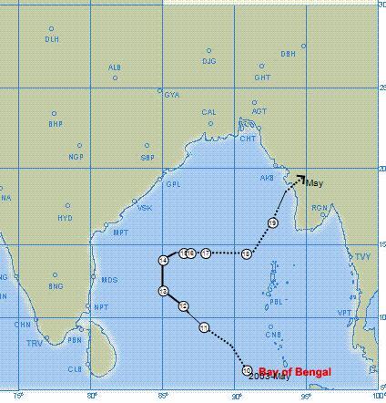
18 SN Year Life period Maximum intensity Basin of formation Season of formation Type of track of TC May VSCS BOB PM SCD L Nov. SCS AS PS RM D May SCS AS PM RM D May SCS BOB PM SCD L Sept. CS BOB Monsoon SM/RM L Nov. 2 Dec. CS BOB PS SM D Dec. CS BOB PS RM L April VSCS BOB PM RM L May CS BOB PM RM L Nov. VSCS BOB PS RM/SCD L April 3 May VSCS BOB PM SCD L Oct. CS BOB PS RM L Nov. CS BOB PS SM L May SCS BOB PM RM L Dec. CS BOB PS SM/SCD L May SCS BOB PM SM/SCS L May CS AS PM SM D May 7 June VSCS AS PM SCD L Oct 4 Nov CS AS PS SM/SCD L Dec VSCS BOB PS SCD L Landfalling/ dissipating TC CS : Cyclonic storm, SCS : Severe cyclonic storm, VSCS : Very severe cyclonic storm, BOB : Bay of Bengal, AS : Arabian Sea RM : Rapid movement, SM : Slow movement, SCD : Sudden change in direction L : Landfalling, D : Dissipating over sea, PM : Pre monsoon, PS : Post monsoon


19 Data and Methodology 1. Six hourly best track data of cyclones over north Indian Ocean since 1990 in digital form hourly data in cyclone Atlas during (Web E Atlas) E Data from are also available in hard copies in 1979 edition of cyclone Atlas
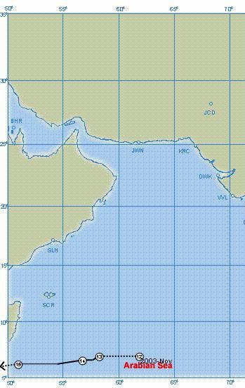
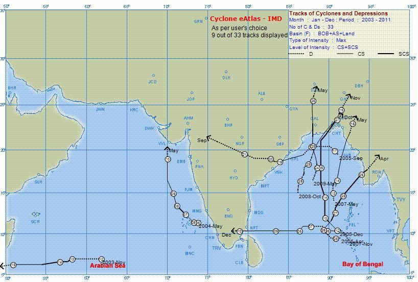
20 Sudden change in direction of movement Out of 33 TCs developed during , 8 TCs had sudden change in direction of movement It consists of two over the AS and six over the BOB. The analysis indicates that both the sudden changes in tracks over the AS occurred when the TC lay to the north of 15 0 N. On the other hand, there are cases of such changes occurring in the BOB to the south of 13 0 N (2 out of 6) While there has been a single case of looping track (over AS), most of the sudden changes in direction have occurred towards right of the previous direction of movement (6 out of 8, 75%). Considering the season of occurrence of such tracks, It has occurred more frequently during pre monsoon (March May) season (5) than in postmonsoon (October December) season (3)

21 Sudden change in direction of movement Recurvature towards right may be attributed to the fact that the TCs over the NIO, while move towards more northerly latitude may recurve towards right under the influence of the deep trough in middle and upper tropospheric westerlies lying to the left of the TC centre. More cases in pre monsoon season may be due to recurvature under influence of trough in westerlies which is predominant in pre monsoon season. Another feature which contributed to the sudden change in direction of movement towards right is the middle/ upper tropospheric steering ridge/ anti cyclonic circulation lying to the east of the TC centre
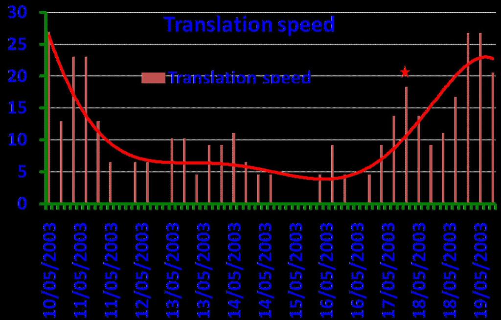
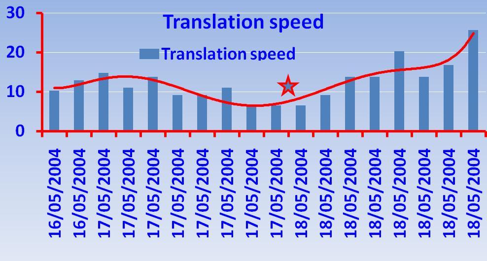
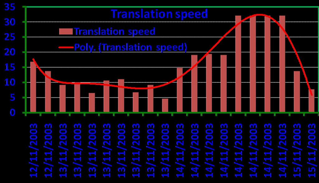
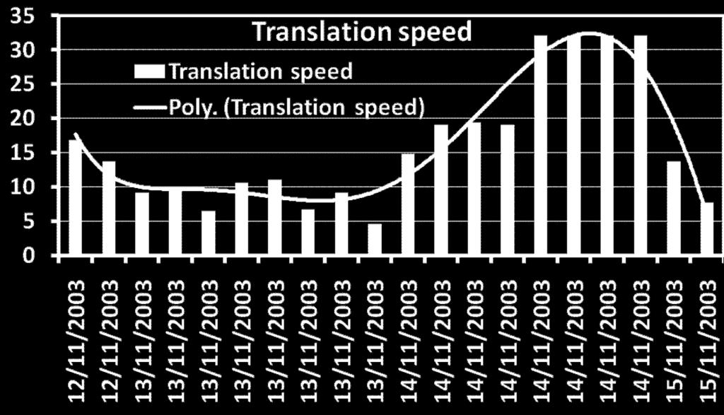
22 Translation speed and sudden change in direction of TCs


23 Translation speed and sudden change in direction of TCs
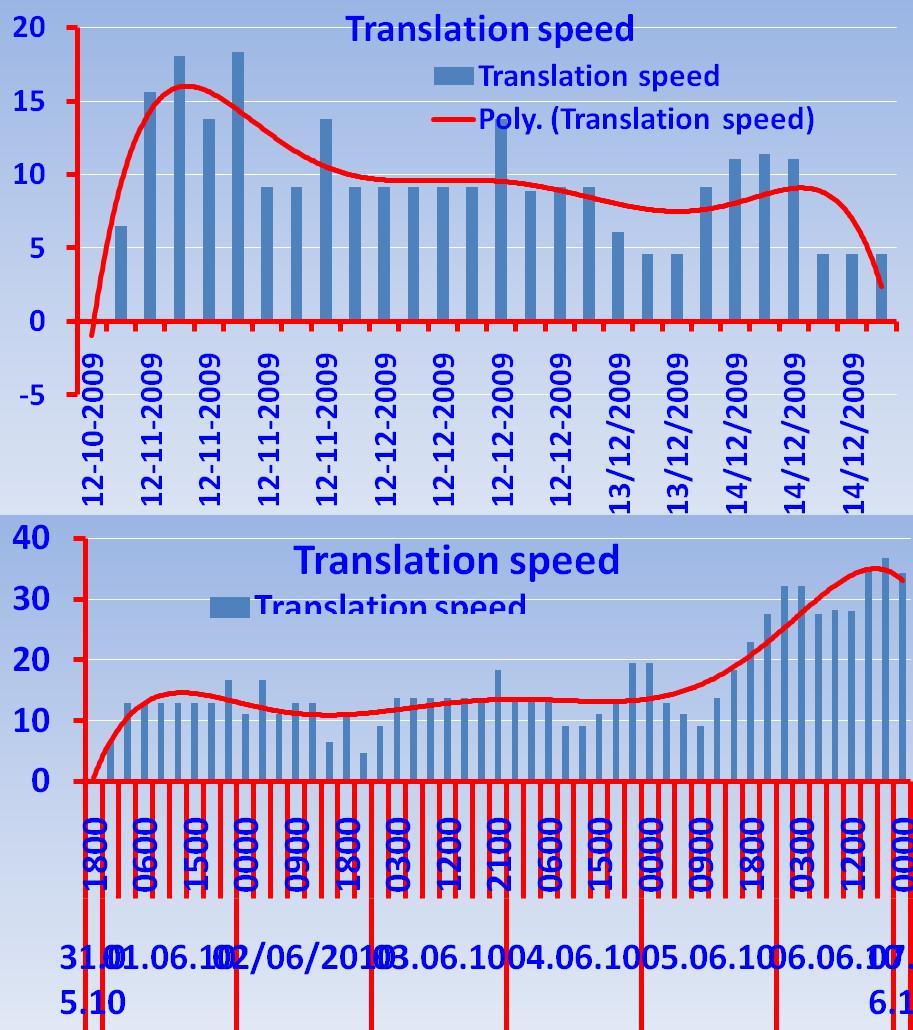

24 Translation speed and sudden change in direction of TCs
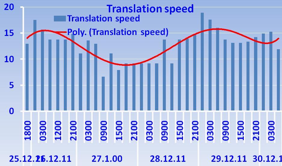
25 Translation speed and sudden change in direction of TCs

26 Translation speed and sudden change in direction of TCs To summarise, the translation speed gradually decreases for about 24 hrs period pror to change in direction of movement. Minimum translation speed becomes about 10 kmph in most of the cases This is true for both cases of increase in northerly and southerly components during the change
27 Impact of MJO on sudden change in track : The track is less sensitive than the genesis and intensity of the cyclonic disturbances over the north Indian Ocean Favourable phases for genesis and intensification are 3, 4 and 5 Genesis of Thane occurred when MJO index was in Phase 4(25 Dec,2011) MJO index then gradually moved with amplitude > 1 through phase 5 to phase 6 Though there was northward movement till 27 th, Thane moved west southwestwards during Dec 2011
28 Impact of MJO on sudden change in track : The track is less sensitive than the genesis and intensity of the cyclonic disturbances over the north Indian Ocean as seen in case of NILAM also (28 31 Oct, 2012) Change in direction took place on 29 th and 30 th with more northnorthwestward movement. there was no significant change in location of MJO index. It continued to be in phase 2, though it slightly moved eastwards on 29 th and 30 th.


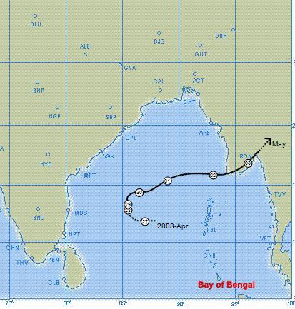
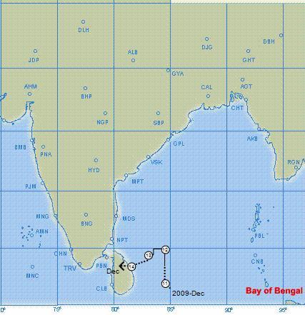
29 Impact of Convection sudden change in track : 27 Dec 2011/0500UTC 12.2N/87.0E 27 Dec 2011/1000UTC 12.2N/86.6E Area of intense convection changed from morthern sector to soutwest sectior on 27th 28 Dec 2011/0300UTC 12.N/85.5E 28 Dec 2011/1000UTC 12.N/84.0E


30 Impact of Convection sudden change in track 28 Dec 2011/1700UTC 12.1N/84.0E 29 Dec 2011/0300UTC 11.9N/82.3E 28 Dec 2011/1400UTC 12.0N/84.0E 29 Dec 2011/0500UTC 11.8N/82.1E Area of intense convection consolidated around system centre gradually on 29th


31 Impact of convection on sudden change in track Southward shifting of area of intense convection is also seen in DWR imageries


32 Impact of convection on sudden change in track : Area of intense convection again shifted to north at the time of landfall


33 Impact of steering ridge, vorticity and large scale circulation on sudden change in track Example : Very Severe Cyclonic storm Thane


34 Impact of steering ridge, vorticity and large scale circulation on sudden change in track


35 Impact of steering ridge, vorticity and large scale circulation on sudden change in track


36 Impact of steering ridge, vorticity and large scale circulation on sudden change in track


37 Impact of steering ridge, vorticity and large scale circulation on sudden change in track


38 Impact of steering ridge, vorticity and large scale circulation on sudden change in track Example : Cyclonic storm NILAM (28 Oct 01 Nov, 2012) Anti cyclone located to northeast of system Ridge extended southward on 26th


39 Impact of steering ridge, vorticity and large scale circulation on sudden change in track Anti cyclone located to northeast of system Ridge extended southward on 27th


40 Impact of steering ridge, vorticity and large scale circulation Anti cyclone is less marked Extension of ridge to south reduced


41 Impact of steering ridge, vorticity and large scale circulation
42 Track Forecast verification of Cyclonic Storm, NILAM The track of cyclone Thane (28 31 Oct 2012) with rapid change in direction followed the principle of interaction between the TC, convection and anticyclonic circulation Using this principle, the change in track could be predicted well l in advance Considering the NWP models, the track could be better predicted by ECMWF model Track Forecast Error, NILAM Lead Period (hr) Error (km)
43 Track Forecast verification of Very severe Cyclonic Storm, THANE The track of cyclone Thane (25 31 Dec 2011) with rapid change in direction followed the principle of interaction between the TC, convection and anticyclonic circulation Using this principle, the change in track could be predicted well l in advance Considering the NWP models, the track could be better predicted by ECMWF model
44 An examples of landfalling Cyclones Very severe cyclonic storm Thane (25 31 Dec. 2011) Landfall of Thane occurred near Cuddalore on 30 th December 2011(morning) Landfall error : 24 hrs : 20 km, 48 hrs : 160 km, 72 hrs : 140 km k Death toll was only 46 due to improved early warning alongwith preparedness and management Forecast on 26 th Dec Morning (four days prior to landfall) Observed Track
 than over the AS (2).")
45 Rapid movement near coast There were 9 out of 33 TCs developed during , which moved rapidly while approaching the coast. It consists of two over the AS and seven over the BOB. The analysis indicates that rapid movement took place mostly with the straight movers or with minimal recurvature.. Such TCs are also higher over the BOB (7) than over the AS (2). The rapid movement could take place in all latitudes. There is also no seasonal bias in the occurrence of rapidly moving TCs as almost equal number of such TCs occurred in both pre monsoon and postmonsoon seasons. Rapid movement in case of northeastward recurving system is mainly under influence of the trough in middle and upper tropospheric westerlies,reason for rapid movement in case of westward moving TCs needs further investigation.
46 Translation speed and Rapid movement of TCs Translation speed can go upto kmph
47 Slow movement near coast There were seven out of 33 TCs during which showed slow movement near the coast. It includes 2 over AS and 5 over the BOB. It consisted of one looping TC over the AS and three recurving TCs over the BOB. The slow moving TCs mostly occurred to the south of 15 0 N in both BOB and AS unlike the rapidly moving TCs and TC showing sudden change in direction. The role of land surface processes in accelerating and retarding the speed of TC approaching the coast needs investigation.
 20 0 45 40 CS SCS VSCS SUCS ALL TCs 35 Frequency (%) 30 25 20 15 10 5 0 April May October November Month")
48 Characteristics of Rapid Intensification over NIO 20 ( ) 100 Frequency (%) Frequency (%) dv 24 (kt) CS SCS VSCS SUCS ALL TCs 35 Frequency (%) April May October November Month
49 Rapid Intensification over NIO ( ) The composite probability of RI determined for the dependent sample. The probabilities are provided as a function of the total number of the eight RI predictor indices that were satisfied. The sample mean probability of RI is also shown for reference. The number of cases is shown in parentheses beside the total number of RI indices satisfied (Kotal et al, 2012) RI cases are embedded in regions with higher Upper level divergence, Lower level relative vorticity and Relative humidity and low vertical wind shear Initial wind speed of RI cases is higher and tends to move with a faster translational speed than the non RI cases. Probability of RI (%) Dependent Sample mean 0(17) 1(58) 2(117) 3(115) 4(96) 5(41) 6(25) 7(11) 8(3) Total number of RI Indices satisfied
50 Summary Translational speed of TC decreases to less than 10 kmph 24 hrs preceding the sudden change in track The interaction between TC, convection and steering ridge mainly determine the sudden change in direction of movement of TC MJO does not seem to be very influential in causing sudden track changes direction of movement of TCs mostly occur at higher latitudes (north of 15 0 N over AS and north of 13 0 N over BOB). Stationarity of TC near the coast needs further investigation Reason for rapid movement in case of westward moving TCs needs further investigation. Also, the role of land surface processes in accelerating and retarding the speed of TC approaching the coast needs investigation.
51 Conclusions Sudden change in direction before landfall and rapid increase in intensity before landfall creates problems for disaster management apart from increasing the forecast error. Currently, forecasters are able to predict rapid intensification based on nowcasting basis (upto 6 hrs) using microwave products to evaluate the trend in upper tropospheric warming, low level wind and burst of convection in association with favourable factors like low vertical wind shear. But is not sufficient for disaster managers Hence there is need to improve the NWP models and dynamical statistical models for RI Comparing existing models, ECMWF model performs better in predicting sudden change in track and intensity. There is need to factor in the interaction of storm scale with mesoscale and convection scale in the NWP models with better data assimilation and increased resolution.
52 Thank you
ANNOUNCEMENT WMO/ESCAP PANEL ON TROPICAL CYCLONES THIRTY-EIGHTH SESSION NEW DELHI, INDIA
 WMO IMD ESCAP ANNOUNCEMENT THIRTY-EIGHTH SESSION NEW DELHI, INDIA (21-25 February 2011) HISTORICAL BACKGROUND The tropical cyclones are particularly severe in the north Indian Ocean region. The northern
Government of Sultanate of Oman Public Authority of Civil Aviation Directorate General of Meteorology. National Report To
 Government of Sultanate of Oman Public Authority of Civil Aviation Directorate General of Meteorology National Report To Panel on Tropical Cyclones in the Bay of Bengal And Arabian Sea 43rd Session, India
TROPICAL CYCLONE TC 03A FOR THE PERIOD 3 RD JUNE TO 10 TH JUNE, 1998
 TROPICAL CYCLONE TC 03A FOR THE PERIOD 3 RD JUNE TO 10 TH JUNE, 1998 Hazrat Mir, Abdul Rashid, Waqarul Wheed Khan. Introduction: This report gives the review of cyclonic storm formed over the East Arabian
Best track data of tropical cyclonic disturbances. over the north Indian Ocean. Regional Specialised Meteorological Centre (RSMC) -
 -") Best track data of tropical cyclonic disturbances over the north Indian Ocean Regional Specialised Meteorological Centre (RSMC) - Tropical Cyclones, New Delhi Cyclone Warning Division, India Meteorological
Best track data of tropical cyclonic disturbances over the north Indian Ocean Regional Specialised Meteorological Centre (RSMC) - Tropical Cyclones, New Delhi Cyclone Warning Division, India Meteorological
UPDATE OF REGIONAL WEATHER AND SMOKE HAZE (December 2017)
") UPDATE OF REGIONAL WEATHER AND SMOKE HAZE (December 2017) 1. Review of Regional Weather Conditions for November 2017 1.1 In November 2017, Southeast Asia experienced inter-monsoon conditions in the first
UPDATE OF REGIONAL WEATHER AND SMOKE HAZE (December 2017) 1. Review of Regional Weather Conditions for November 2017 1.1 In November 2017, Southeast Asia experienced inter-monsoon conditions in the first
Verification of the Seasonal Forecast for the 2005/06 Winter
 Verification of the Seasonal Forecast for the 2005/06 Winter Shingo Yamada Tokyo Climate Center Japan Meteorological Agency 2006/11/02 7 th Joint Meeting on EAWM Contents 1. Verification of the Seasonal
1. Introduction. 2. Verification of the 2010 forecasts. Research Brief 2011/ February 2011
 Research Brief 2011/01 Verification of Forecasts of Tropical Cyclone Activity over the Western North Pacific and Number of Tropical Cyclones Making Landfall in South China and the Korea and Japan region
Life Cycle of Convective Systems over Western Colombia
 Life Cycle of Convective Systems over Western Colombia Meiry Sakamoto Uiversidade de São Paulo, São Paulo, Brazil Colombia Life Cycle of Convective Systems over Western Colombia Convective System (CS)
Intensity of North Indian Ocean Tropical Cyclones
 Chapter 6 Intensity of North Indian Ocean Tropical Cyclones 6.1 Introduction Intensity of tropical cyclones is dependent on several parameters both thermodynamic and dynamic. It includes thermodynamic
Tropical Storm List
 Tropical Storm Email List http://tstorms.org/ tropical-storms@tstorms.org Tropical-Storms is a mailing list only for those who are professionally active in either the research or forecasting of tropical
Activities of RSMC, New Delhi B.K.BANDYOPADHYAY
 Activities of RSMC, New Delhi B.K.BANDYOPADHYAY Layout Functions of RSMC, New Delhi Climatology of NIO Observational network Telecommunication network Cyclone monitoring Cyclone forecasting Bulletins/Advisories
ROLE OF INDIA METEOROLOGICAL DEPARTMENT IN MANAGEMENT OF METEOROLOGICAL HAZARDS IN INDIA M MOHAPATRA
 ROLE OF INDIA METEOROLOGICAL DEPARTMENT IN MANAGEMENT OF METEOROLOGICAL HAZARDS IN INDIA M MOHAPATRA INDIA METEOROLOGICAL DEPARTMENT NEW DELHI-110003 mohapatraimd@gmail.com Introduction Presentation layout
(April 7, 2010, Wednesday) Tropical Storms & Hurricanes Part 2
 Tropical Storms & Hurricanes Part 2") Lecture #17 (April 7, 2010, Wednesday) Tropical Storms & Hurricanes Part 2 Hurricane Katrina August 2005 All tropical cyclone tracks (1945-2006). Hurricane Formation While moving westward, tropical disturbances
Lecture #17 (April 7, 2010, Wednesday) Tropical Storms & Hurricanes Part 2 Hurricane Katrina August 2005 All tropical cyclone tracks (1945-2006). Hurricane Formation While moving westward, tropical disturbances
ESCI 241 Meteorology Lesson 19 Tropical Cyclones Dr. DeCaria
 ESCI 241 Meteorology Lesson 19 Tropical Cyclones Dr. DeCaria READING: Chapter 16 GENERAL A tropical cyclone is a large, low-pressure system that forms over the tropical oceans. Tropical cyclones are classified
DR RAJENDRA KUMAR JENAMANI
 TCAC NEW DELHI METHODS AND PROCEDURES USED FOR PREDICTION DR RAJENDRA KUMAR JENAMANI Director In-Charge Meteorological Watch Office (MWO) INDIA METEOROLOGICAL DEPARTMENT New ATS Building (Room No.-211,
International Journal of Integrated Sciences & Technology 2 (2016) 55-61
 55-61") International Journal of Integrated Sciences & Technology 2 (2016) 55-61 Changes in Latent Heat Energy and Moist Static Energy Contents of the Atmosphere over Bangladesh and Neighbourhood during the Formation
International Journal of Integrated Sciences & Technology 2 (2016) 55-61 Changes in Latent Heat Energy and Moist Static Energy Contents of the Atmosphere over Bangladesh and Neighbourhood during the Formation
M. Mohapatra and D. R. Pattanaik
 Understanding and forecasting of intra-seasonal extremes of southwest monsoon circulation and precipitation over India M. Mohapatra and D. R. Pattanaik IMD, New Delhi Email : m.mohapatra@imd.gov.in Annual
Reduction of the Radius of Probability Circle. in Typhoon Track Forecast
 Reduction of the Radius of Probability Circle in Typhoon Track Forecast Nobutaka MANNOJI National Typhoon Center, Japan Meteorological Agency Abstract RSMC Tokyo - Typhoon Center of the Japan Meteorological
7 December 2016 Tokyo Climate Center, Japan Meteorological Agency
 Summary of the 2016 Asian Summer Monsoon 7 December 2016 Tokyo Climate Center, Japan Meteorological Agency This report summarizes the characteristics of the surface climate and atmospheric/oceanographic
Fernando Prates. Evaluation Section. Slide 1
 Fernando Prates Evaluation Section Slide 1 Objectives Ø Have a better understanding of the Tropical Cyclone Products generated at ECMWF Ø Learn the recent developments in the forecast system and its impact
Analysis of Fall Transition Season (Sept-Early Dec) Why has the weather been so violent?
 Why has the weather been so violent?") WEATHER TOPICS Analysis of Fall Transition Season (Sept-Early Dec) 2009 Why has the weather been so violent? As can be seen by the following forecast map, the Fall Transition and early Winter Season of
WEATHER TOPICS Analysis of Fall Transition Season (Sept-Early Dec) 2009 Why has the weather been so violent? As can be seen by the following forecast map, the Fall Transition and early Winter Season of
August Forecast Update for Atlantic Hurricane Activity in 2012
 August Forecast Update for Atlantic Hurricane Activity in 2012 Issued: 6 th August 2012 by Professor Mark Saunders and Dr Adam Lea Dept. of Space and Climate Physics, UCL (University College London), UK
The 2009 Hurricane Season Overview
 The 2009 Hurricane Season Overview Jae-Kyung Schemm Gerry Bell Climate Prediction Center NOAA/ NWS/ NCEP 1 Overview outline 1. Current status for the Atlantic, Eastern Pacific and Western Pacific basins
Long Range Forecasts of 2015 SW and NE Monsoons and its Verification D. S. Pai Climate Division, IMD, Pune
 Long Range Forecasts of 2015 SW and NE Monsoons and its Verification D. S. Pai Climate Division, IMD, Pune Other Contributors: Soma Sen Roy, O. P. Sreejith, Kailas, Madhuri, Pallavi, Mahendra and Jasmine
Prediction of western disturbances and associated weather over Western Himalayas
 Prediction of western disturbances and associated weather over Western Himalayas H. R. Hatwar*, B. P. Yadav and Y. V. Rama Rao India Meteorological Department, Lodi Road, New Delhi 110 003, India Two cases
NHC Ensemble/Probabilistic Guidance Products
 NHC Ensemble/Probabilistic Guidance Products Michael Brennan NOAA/NWS/NCEP/NHC Mark DeMaria NESDIS/STAR HFIP Ensemble Product Development Workshop 21 April 2010 Boulder, CO 1 Current Ensemble/Probability
Thai Meteorological Department, Ministry of Digital Economy and Society
 Thai Meteorological Department, Ministry of Digital Economy and Society Three-month Climate Outlook For November 2017 January 2018 Issued on 31 October 2017 -----------------------------------------------------------------------------------------------------------------------------
KUALA LUMPUR MONSOON ACTIVITY CENT
 T KUALA LUMPUR MONSOON ACTIVITY CENT 2 ALAYSIAN METEOROLOGICAL http://www.met.gov.my DEPARTMENT MINISTRY OF SCIENCE. TECHNOLOGY AND INNOVATIO Introduction Atmospheric and oceanic conditions over the tropical
Seasonal Climate Outlook for South Asia (June to September) Issued in May 2014
 Issued in May 2014") Ministry of Earth Sciences Earth System Science Organization India Meteorological Department WMO Regional Climate Centre (Demonstration Phase) Pune, India Seasonal Climate Outlook for South Asia (June
Ministry of Earth Sciences Earth System Science Organization India Meteorological Department WMO Regional Climate Centre (Demonstration Phase) Pune, India Seasonal Climate Outlook for South Asia (June
Have a better understanding of the Tropical Cyclone Products generated at ECMWF
 Objectives Have a better understanding of the Tropical Cyclone Products generated at ECMWF Learn about the recent developments in the forecast system and its impact on the Tropical Cyclone forecast Learn
Probabilistic Evaluation of Prediction and Dynamics of Super Typhoon MEGI (2010)
") Probabilistic Evaluation of Prediction and Dynamics of Super Typhoon MEGI (2010) 6 November 2012 Chuanhai Qian 1, Fuqing Zhang 2, Yihong Duan 1 1 China Meteorological Administration 2 Pennsylvania State
Probabilistic Evaluation of Prediction and Dynamics of Super Typhoon MEGI (2010) 6 November 2012 Chuanhai Qian 1, Fuqing Zhang 2, Yihong Duan 1 1 China Meteorological Administration 2 Pennsylvania State
Vertical wind shear in relation to frequency of Monsoon Depressions and Tropical Cyclones of Indian Seas
 Vertical wind shear in relation to frequency of Monsoon Depressions and Tropical Cyclones of Indian Seas Prince K. Xavier and P.V. Joseph Department of Atmospheric Sciences Cochin University of Science
UPDATE OF REGIONAL WEATHER AND SMOKE HAZE (May 2017)
") UPDATE OF REGIONAL WEATHER AND SMOKE HAZE (May 2017) 1. Review of Regional Weather Conditions in April 2017 1.1 Inter monsoon conditions, characterised by afternoon showers and winds that are generally
UPDATE OF REGIONAL WEATHER AND SMOKE HAZE (May 2017) 1. Review of Regional Weather Conditions in April 2017 1.1 Inter monsoon conditions, characterised by afternoon showers and winds that are generally
NUMERICAL SIMULATION OF A BAY OF BENGAL TROPICAL CYCLONE: A COMPARISON OF THE RESULTS FROM EXPERIMENTS WITH JRA-25 AND NCEP REANALYSIS FIELDS
 NUMERICAL SIMULATION OF A BAY OF BENGAL TROPICAL CYCLONE: A COMPARISON OF THE RESULTS FROM EXPERIMENTS WITH JRA-25 AND NCEP REANALYSIS FIELDS Dodla Venkata Bhaskar Rao Desamsetti Srinivas and Dasari Hari
UPDATE OF REGIONAL WEATHER AND SMOKE HAZE (February 2018)
") UPDATE OF REGIONAL WEATHER AND SMOKE HAZE (February 2018) 1. Review of Regional Weather Conditions for January 2018 1.1 The prevailing Northeast monsoon conditions over Southeast Asia strengthened in January
UPDATE OF REGIONAL WEATHER AND SMOKE HAZE (February 2018) 1. Review of Regional Weather Conditions for January 2018 1.1 The prevailing Northeast monsoon conditions over Southeast Asia strengthened in January
Suppressed Surface Heating over northwestern parts of the Country and the ensuing Monsoon Rainfall
 Suppressed Surface Heating over northwestern parts of the Country and the ensuing Monsoon Rainfall During this year, the temperatures have been below normal over north and northwestern parts of India.
Hurricanes and Tropical Weather Systems:
 Hurricanes and Tropical Weather Systems: An influence on weather in parts of the USA Meteorology 411 Iowa State University Week 2 Bill Gallus Classification/Terminology Tropical Disturbance enhanced convection
8.1 Attachment 1: Ambient Weather Conditions at Jervoise Bay, Cockburn Sound
 8.1 Attachment 1: Ambient Weather Conditions at Jervoise Bay, Cockburn Sound Cockburn Sound is 20km south of the Perth-Fremantle area and has two features that are unique along Perth s metropolitan coast
April Forecast Update for North Atlantic Hurricane Activity in 2019
 April Forecast Update for North Atlantic Hurricane Activity in 2019 Issued: 5 th April 2019 by Professor Mark Saunders and Dr Adam Lea Dept. of Space and Climate Physics, UCL (University College London),
August Forecast Update for Atlantic Hurricane Activity in 2016
 August Forecast Update for Atlantic Hurricane Activity in 2016 Issued: 5 th August 2016 by Professor Mark Saunders and Dr Adam Lea Dept. of Space and Climate Physics, UCL (University College London), UK
April Forecast Update for Atlantic Hurricane Activity in 2018
 April Forecast Update for Atlantic Hurricane Activity in 2018 Issued: 5 th April 2018 by Professor Mark Saunders and Dr Adam Lea Dept. of Space and Climate Physics, UCL (University College London), UK
Issued by the: Climate Services Division Fiji Meteorological Service Nadi Airport. 27 October 2010 GENERAL STATEMENT
 Fiji Meteorological Service (FMS) Tropical Cyclone Guidance for Season 2010/11 for the Fiji and the Southwest Pacific RSMC Region 160E to 120W Equator to 25 South Issued by the: Climate Services Division
August Forecast Update for Atlantic Hurricane Activity in 2015
 August Forecast Update for Atlantic Hurricane Activity in 2015 Issued: 5 th August 2015 by Professor Mark Saunders and Dr Adam Lea Dept. of Space and Climate Physics, UCL (University College London), UK
Tri-Agency Forecast Discussion for August 24, 2010
 Created 1600 UTC August 24, 2010 Tri-Agency Forecast Discussion for August 24, 2010 GRIP Forecast Team: Cerese Inglish, Matt Janiga, Andrew Martin, Dan Halperin, Jon Zawislak, Ellen Ramirez, Amber Reynolds,
South Asian Climate Outlook Forum (SASCOF-6)
") Sixth Session of South Asian Climate Outlook Forum (SASCOF-6) Dhaka, Bangladesh, 19-22 April 2015 Consensus Statement Summary Below normal rainfall is most likely during the 2015 southwest monsoon season
Sixth Session of South Asian Climate Outlook Forum (SASCOF-6) Dhaka, Bangladesh, 19-22 April 2015 Consensus Statement Summary Below normal rainfall is most likely during the 2015 southwest monsoon season
Current Details from the Joint Typhoon Warning Center
 Current Details from the Joint Warning Center COORDINATES: 19.6 north, 125.5 east (previous location: 17.9 north, 130.3 east) LOCATION: 737 kilometers (458 miles) southeast of Taipei, Taiwan MOVEMENT:
2016 Hurricane Season Preview
 2016 Hurricane Season Preview Eric Uhlhorn, Ph.D. 1 2 Recap of 2015 Hurricane Season - El Niño played a significant role in activity - Atlantic activity was slightly below normal 11 named storms, 4 hurricanes,
GPC Exeter forecast for winter Crown copyright Met Office
 GPC Exeter forecast for winter 2015-2016 Global Seasonal Forecast System version 5 (GloSea5) ensemble prediction system the source for Met Office monthly and seasonal forecasts uses a coupled model (atmosphere
July Forecast Update for North Atlantic Hurricane Activity in 2018
 July Forecast Update for North Atlantic Hurricane Activity in 2018 Issued: 5 th July 2018 by Professor Mark Saunders and Dr Adam Lea Dept. of Space and Climate Physics, UCL (University College London),
2013 ATLANTIC HURRICANE SEASON OUTLOOK. June RMS Cat Response
 2013 ATLANTIC HURRICANE SEASON OUTLOOK June 2013 - RMS Cat Response Season Outlook At the start of the 2013 Atlantic hurricane season, which officially runs from June 1 to November 30, seasonal forecasts
EFFECTIVE TROPICAL CYCLONE WARNING IN BANGLADESH
 Country Report of Bangladesh On EFFECTIVE TROPICAL CYCLONE WARNING IN BANGLADESH Presented At JMA/WMO WORKSHOP ON EFFECTIVE TROPICAL CYCLONE WARNING IN SOUTHEAST ASIA Tokyo, Japan,11-14 March 2014 By Sayeed
Meteorological Hazards and Current Approach to Observing, Modelling and Predicting Severe Events in Sri Lanka
 Regional Workshop on Impact-based Forecasts in RA II (Asia) 7-9, November, 2017, Seoul, Republic of Korea Meteorological Hazards and Current Approach to Observing, Modelling and Predicting Severe Events
South Asian Climate Outlook Forum (SASCOF-12)
") Twelfth Session of South Asian Climate Outlook Forum (SASCOF-12) Pune, India, 19-20 April 2018 Consensus Statement Summary Normal rainfall is most likely during the 2018 southwest monsoon season (June
Twelfth Session of South Asian Climate Outlook Forum (SASCOF-12) Pune, India, 19-20 April 2018 Consensus Statement Summary Normal rainfall is most likely during the 2018 southwest monsoon season (June
UPDATE OF REGIONAL WEATHER AND SMOKE HAZE (September 2017)
") UPDATE OF REGIONAL WEATHER AND SMOKE HAZE (September 2017) 1. Review of Regional Weather Conditions in August 2017 1.1 Southwest Monsoon conditions continued to prevail in the region in August 2017. The
UPDATE OF REGIONAL WEATHER AND SMOKE HAZE (September 2017) 1. Review of Regional Weather Conditions in August 2017 1.1 Southwest Monsoon conditions continued to prevail in the region in August 2017. The
SUMMARY OF THE 2011 TYPHOON SEASON
 ECONOMIC AND SOCIAL COMMISSION FOR ASIA AND THE PACIFIC AND WORLD METEOROLOGICAL ORGANIZATION WRD/TC.44/4.1 Add. 2 06 February 2012 Typhoon Committee Forty Fourth Session 06 to 12 February 2012 Hangzhou,
July Forecast Update for Atlantic Hurricane Activity in 2016
 July Forecast Update for Atlantic Hurricane Activity in 2016 Issued: 5 th July 2016 by Professor Mark Saunders and Dr Adam Lea Dept. of Space and Climate Physics, UCL (University College London), UK Forecast
Evidence for Weakening of Indian Summer Monsoon and SA CORDEX Results from RegCM
 Evidence for Weakening of Indian Summer Monsoon and SA CORDEX Results from RegCM S K Dash Centre for Atmospheric Sciences Indian Institute of Technology Delhi Based on a paper entitled Projected Seasonal
3. HYDROMETEROLOGY. 3.1 Introduction. 3.2 Hydro-meteorological Aspect. 3.3 Rain Gauge Stations
 3. HYDROMETEROLOGY 3.1 Introduction Hydrometeorology is a branch of meteorology and hydrology that studies the transfer of water and energy between the land surface and the lower atmosphere. Detailed hydrological
1. INTRODUCTION: 2. DATA AND METHODOLOGY:
 27th Conference on Hurricanes and Tropical Meteorology, 24-28 April 2006, Monterey, CA 3A.4 SUPERTYPHOON DALE (1996): A REMARKABLE STORM FROM BIRTH THROUGH EXTRATROPICAL TRANSITION TO EXPLOSIVE REINTENSIFICATION
Pre-Season Forecast for North Atlantic Hurricane Activity in 2018
 Pre-Season Forecast for North Atlantic Hurricane Activity in 2018 Issued: 30 th May 2018 by Professor Mark Saunders and Dr Adam Lea Dept. of Space and Climate Physics, UCL (University College London),
Upgrade of JMA s Typhoon Ensemble Prediction System
 Upgrade of JMA s Typhoon Ensemble Prediction System Masayuki Kyouda Numerical Prediction Division, Japan Meteorological Agency and Masakazu Higaki Office of Marine Prediction, Japan Meteorological Agency
Ensemble Prediction Systems
 Ensemble Prediction Systems Eric Blake National Hurricane Center 7 March 2017 Acknowledgements to Michael Brennan 1 Question 1 What are some current advantages of using single-model ensembles? A. Estimates
Current Details from the Joint Typhoon Warning Center
 Current Details from the Joint Warning Center COORDINATES: 10.2 north, 148.1 east (previous location: 10.1 north, 148.3 east) LOCATION: 520 kilometers (325 miles) southeast of Andersen Air Force Base,
July Forecast Update for Atlantic Hurricane Activity in 2017
 July Forecast Update for Atlantic Hurricane Activity in 2017 Issued: 4 th July 2017 by Professor Mark Saunders and Dr Adam Lea Dept. of Space and Climate Physics, UCL (University College London), UK Forecast
Convective-scale NWP for Singapore
 Convective-scale NWP for Singapore Hans Huang and the weather modelling and prediction section MSS, Singapore Dale Barker and the SINGV team Met Office, Exeter, UK ECMWF Symposium on Dynamical Meteorology
Atmospheric circulation analysis for seasonal forecasting
 Training Seminar on Application of Seasonal Forecast GPV Data to Seasonal Forecast Products 18 21 January 2011 Tokyo, Japan Atmospheric circulation analysis for seasonal forecasting Shotaro Tanaka Climate
Numerical Simulation of a Severe Thunderstorm over Delhi Using WRF Model
 International Journal of Scientific and Research Publications, Volume 5, Issue 6, June 2015 1 Numerical Simulation of a Severe Thunderstorm over Delhi Using WRF Model Jaya Singh 1, Ajay Gairola 1, Someshwar
Challenging Aspects of Severe Tropical Cyclone George s s Track Forecasts
 Challenging Aspects of Severe Tropical Cyclone George s s Track Forecasts Jim DAVIDSON Former Affilliation Severe Tropical Cyclone George bears down on the Western Australian Coast in early March 2007
DBCP 2012 SCIENTIFIC AND TECHNICAL WORKSHOP Fremantle, Australia, 2 October 2012 SALIENT FEATURES OF INDIAN DEEP SEA INSTRUMENTED BUOY NETWORK IN THE
 DBCP 2012 SCIENTIFIC AND TECHNICAL WORKSHOP Fremantle, Australia, 2 October 2012 SALIENT FEATURES OF INDIAN DEEP SEA INSTRUMENTED BUOY NETWORK IN THE BAY OF BENGAL R. Venkatesan, Arul Muthiah, Simi Mathew
Chapter 24. Tropical Cyclones. Tropical Cyclone Classification 4/19/17
 Chapter 24 Tropical Cyclones Tropical Cyclones Most destructive storms on the planet Originate over tropical waters, but their paths often take them over land and into midlatitudes Names Hurricane (Atlantic
Synoptic situations of severe local convective storms during the pre-monsoon season in Bangladesh
 INTERNATIONAL JOURNAL OF CLIMATOLOGY Int. J. Climatol. 33: 725 734 (2013) Published online 13 March 2012 in Wiley Online Library (wileyonlinelibrary.com) DOI: 10.1002/joc.3460 Synoptic situations of severe
5 Atmospheric Disturbances 7 1.Cyclones- tropical and temperate and associated weather conditions. 2.Anticyclones and associated weather conditions.
 5 Atmospheric Disturbances 7 1.Cyclones- tropical and temperate and associated weather conditions. 2.Anticyclones and associated weather conditions. atmospheric disturbances (weather systems) that are
Introduction to tropical meteorology and deep convection
 Introduction to tropical meteorology and deep convection TMD Lecture 1 Roger K. Smith University of Munich A satpix tour of the tropics The zonal mean circulation (Hadley circulation), Inter- Tropical
Outline of 4 Lectures
 Outline of 4 Lectures 1. Sept. 17, 2008: TC best track definition and datasets, global distribution of TCs; Review of history of meteorological satellites, introducing different orbits, scanning patterns,
Recent studies on tropical cyclone landfalling in China
 Recent studies on tropical cyclone landfalling in China Lei Xiaotu Shanghai Typhoon Institute CMA, Shanghai, China email: xtlei@21cn.com 1. Losses caused by tropical cyclones in China China is one of the
Department of Atmospheric Sciences, National Taiwan University, Taipei, Taiwan
 10A.4 TROPICAL CYCLONE FORMATIONS IN THE SOUTH CHINA SEA CHENG-SHANG LEE 1 AND YUNG-LAN LIN* 1, 2 1 Department of Atmospheric Sciences, National Taiwan University, Taipei, Taiwan 2 Taipei Aeronautic Meteorological
Estimation of pressure drop and storm surge height associated to tropical cyclone using Doppler velocity
 Indian Journal of Radio & Space Physics Vol 41, June 2012, pp 348-358 Estimation of pressure drop and storm surge height associated to tropical cyclone using Doppler velocity Devendra Pradhan 1,$,*, Anasuya
April Forecast Update for Atlantic Hurricane Activity in 2016
 April Forecast Update for Atlantic Hurricane Activity in 2016 Issued: 5 th April 2016 by Professor Mark Saunders and Dr Adam Lea Dept. of Space and Climate Physics, UCL (University College London), UK
Tokyo, Japan March Discussed By: May Khin Chaw, Kyaw Lwin Oo. Department of Meteorology and Hydrology
 Tokyo, Japan 11-14 March 2014 Discussed By: May Khin Chaw, Kyaw Lwin Oo Department of Meteorology and Hydrology Manpower: Out of DMH s total (1425), we are Working with (780) Staffs. 55% (37) stations
PRMS WHITE PAPER 2014 NORTH ATLANTIC HURRICANE SEASON OUTLOOK. June RMS Event Response
 PRMS WHITE PAPER 2014 NORTH ATLANTIC HURRICANE SEASON OUTLOOK June 2014 - RMS Event Response 2014 SEASON OUTLOOK The 2013 North Atlantic hurricane season saw the fewest hurricanes in the Atlantic Basin
Topic 3.2: Tropical Cyclone Variability on Seasonal Time Scales (Observations and Forecasting)
") Topic 3.2: Tropical Cyclone Variability on Seasonal Time Scales (Observations and Forecasting) Phil Klotzbach 7 th International Workshop on Tropical Cyclones November 18, 2010 Working Group: Maritza Ballester
Topic 3.2: Tropical Cyclone Variability on Seasonal Time Scales (Observations and Forecasting) Phil Klotzbach 7 th International Workshop on Tropical Cyclones November 18, 2010 Working Group: Maritza Ballester
1C.4 TROPICAL CYCLONE TORNADOES: SYNOPTIC SCALE INFLUENCES AND FORECASTING APPLICATIONS
 1C.4 TROPICAL CYCLONE TORNADOES: SYNOPTIC SCALE INFLUENCES AND FORECASTING APPLICATIONS Daniel J. Cecil and Lori A. Schultz University of Alabama in Huntsville, Huntsville, AL, 35805 1. INTRODUCTION Several
CHAPTER 12 TROPICAL WEATHER SYSTEMS MULTIPLE CHOICE QUESTIONS
 CHAPTER 12 TROPICAL WEATHER SYSTEMS MULTIPLE CHOICE QUESTIONS 1. A hurricane differs from an extra-tropical cyclone in that a hurricane a. has no fronts. b. develops within a uniform warm and humid air
Topic 2.2 CYCLOGENESIS: OPERATIONAL FORECASTING PERSPECTIVE
 Topic 2.2 CYCLOGENESIS: OPERATIONAL FORECASTING PERSPECTIVE Rapporteur: Christopher W. Landsea National Hurricane Center RSMC Miami 11691 SW 17 th Street Miami, FL, 33165, U.S.A. Email: Chris.Landsea@noaa.gov
On the presence of tropical vortices over the Southeast Asian Sea- Maritime Continent region
 Technical Conference of 50 th Annual Session of Typhoon Committee 2018 On the presence of tropical vortices over the Southeast Asian Sea- Maritime Continent region Nguyen Dang-Quang 1, James Renwick 2,
Weathernews Looks Back at 2015: A Year of Storms. Powerful Typhoons Occurred with Changing Patterns in El Niño Years
 NEWS RELEASE January 27th, 2016 Weathernews Looks Back at 2015: A Year of Storms Powerful Typhoons Occurred with Changing Patterns in El Niño Years Weathernews Inc. (Chiba, Japan; Chihito Kusabiraki/CEO)
SH RI Events. Influence From Patterns Of Different Scale
 SH072014 RI Events Influence From Patterns Of Different Scale RI Explanation * Rapid intensification, approximately an increase of 2 Dvorak T-numbers or 30 knots in 24 hours, frequently occurs in JTWC
Impact of ATOVS data in a mesoscale assimilationforecast system over the Indian region
 Impact of ATOVS data in a mesoscale assimilationforecast system over the Indian region John P. George and Munmun Das Gupta National Centre for Medium Range Weather Forecasting, Department of Science &
AVIATION APPLICATIONS OF A NEW GENERATION OF MESOSCALE NUMERICAL WEATHER PREDICTION SYSTEM OF THE HONG KONG OBSERVATORY
 P452 AVIATION APPLICATIONS OF A NEW GENERATION OF MESOSCALE NUMERICAL WEATHER PREDICTION SYSTEM OF THE HONG KONG OBSERVATORY Wai-Kin WONG *1, P.W. Chan 1 and Ivan C.K. Ng 2 1 Hong Kong Observatory, Hong
Regional Seminar on Aviation Meteorology Service in Asia Beijing, China (11-15 April 2011)
") Regional Seminar on Aviation Meteorology Service in Asia Beijing, China (11-15 April 2011) Aviation Meteorology Service in Myanmar Mr.Hla Shwe Staff Officer Department of Meteorology and Hydrology Myanmar
Regional Seminar on Aviation Meteorology Service in Asia Beijing, China (11-15 April 2011) Aviation Meteorology Service in Myanmar Mr.Hla Shwe Staff Officer Department of Meteorology and Hydrology Myanmar
Analysis on MM5 predictions at Sriharikota during northeast monsoon 2008
 Analysis on MM5 predictions at Sriharikota during northeast monsoon 8 D Gayatri Vani, S Rambabu, M Rajasekhar, GVRama, B V Apparao and A K Ghosh MET-Facility, Satish Dhawan Space Centre, SHAR, ISRO, Sriharikota
A comparative study on performance of MM5 and WRF models in simulation of tropical cyclones over Indian seas
 A comparative study on performance of MM5 and WRF models in simulation of tropical cyclones over Indian seas Sujata Pattanayak and U. C. Mohanty* Centre for Atmospheric Sciences, Indian Institute of Technology
Probabilistic predictions of monsoon rainfall with the ECMWF Monthly and Seasonal Forecast Systems
 Probabilistic predictions of monsoon rainfall with the ECMWF Monthly and Seasonal Forecast Systems Franco Molteni, Frederic Vitart, Tim Stockdale, Laura Ferranti, Magdalena Balmaseda European Centre for
Saiful Islam Anisul Haque
 Workshop on Disaster Prevention/Mitigation Measures against Floods and Storm Surges in Bangladesh on 17-21 November, 2012, in Kyoto University, Japan Component 2: Flood disaster risk assessment and mitigation
South Asian Climate Outlook Forum (SASCOF-8)
") Eighth Session of South Asian Climate Outlook Forum (SASCOF-8) Colombo, Sri Lanka, 25-26 April 2016 Consensus Statement Summary Above-normal rainfall is most likely during the 2016 southwest monsoon season
Eighth Session of South Asian Climate Outlook Forum (SASCOF-8) Colombo, Sri Lanka, 25-26 April 2016 Consensus Statement Summary Above-normal rainfall is most likely during the 2016 southwest monsoon season
A review on recent progresses of THORPEX activities in JMA
 4th THORPEX workshop 31 Oct. 2012, Kunming, China A review on recent progresses of THORPEX activities in JMA Masaomi NAKAMURA Typhoon Research Department Meteorological Research Institute / JMA Contents
ENSO Outlook by JMA. Hiroyuki Sugimoto. El Niño Monitoring and Prediction Group Climate Prediction Division Japan Meteorological Agency
 ENSO Outlook by JMA Hiroyuki Sugimoto El Niño Monitoring and Prediction Group Climate Prediction Division Outline 1. ENSO impacts on the climate 2. Current Conditions 3. Prediction by JMA/MRI-CGCM 4. Summary
Unseasonable weather conditions in Japan in August 2014
 Unseasonable weather conditions in Japan in August 2014 Summary of analysis by the TCC Advisory Panel on Extreme Climatic Events In an extraordinary session held at the Japan Meteorological Agency on 3
An overview of Wet Season Forecasting in the Northern Territory
 TWP-ICE Meeting November 2004 An overview of Wet Season Forecasting in the Northern Territory Lori Chappel Northern Territory Regional Forecasting Centre Australian Government Bureau of Meteorology Day
Analysis of Rainfall and Other Weather Parameters under Climatic Variability of Parbhani ( )
") International Journal of Current Microbiology and Applied Sciences ISSN: 2319-7706 Volume 7 Number 06 (2018) Journal homepage: http://www.ijcmas.com Original Research Article https://doi.org/10.20546/ijcmas.2018.706.295
International Journal of Current Microbiology and Applied Sciences ISSN: 2319-7706 Volume 7 Number 06 (2018) Journal homepage: http://www.ijcmas.com Original Research Article https://doi.org/10.20546/ijcmas.2018.706.295