Activities of RSMC, New Delhi B.K.BANDYOPADHYAY
|
|
|
- Rosamond Jacobs
- 6 years ago
- Views:
Transcription
1 Activities of RSMC, New Delhi B.K.BANDYOPADHYAY
2 Layout Functions of RSMC, New Delhi Climatology of NIO Observational network Telecommunication network Cyclone monitoring Cyclone forecasting Bulletins/Advisories New Initiatives Future Prospects System during 2008 Winds compared with JTWC
3 Functions of RSMC - New Delhi Monitoring Cyclonic Disturbances over the North Indian Ocean (Bay of Bengal and Arabian Sea) Issue of Tropical weather outlook/ Cyclone Advisories to the Panel Countries. Issue of Tropical Cyclone Advisories for Aviation as per the guidelines of ICAO Collection, processing and archival of all data pertaining to cyclonic disturbances and preparation of best track data over the north Indian Ocean, RSMC, New Delhi also exchanges the same data with WMO/ESCAP Panel member countries.
4 Functions of RSMC - New Delhi Preparation of Annual Review, RSMC reports and updating of Cyclone operational cyclone operational plan Running Numerical Models for Cyclone Track prediction (QLM) and Storm Surge prediction models (IIT Delhi) Implementation of Regional Cyclone Operation Plan of WMO/ESCAP Panel Research on Storm Surge, Track & Intensity Prediction Techniques
5 WMO /ESCAP Panel on Tropical Cyclones Established in 1973 Members Bangladesh India (RSMC tropical cyclones New-Delhi) Maldives Myanmar Oman Pakistan Sri Lanka Thailand
6 Special features of the North Indian Ocean Bay of Bengal is a vast warm pool adjoining the warm pool of the western North Pacific. Several of the precursors of the Bay of Bengal cyclones emerge from the neighbouring Pacific basin as remnant of typhoons and re-intensify over the Bay after passing over rather narrow strip of SE Asian countries The ocean currents in the Bay of Bengal are quite complex. The bathymetry of this coast is also very complex due to a number of rivers, deltaic regions and orography
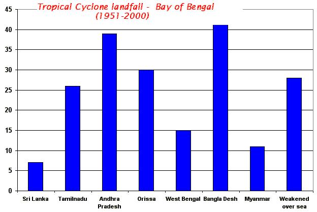
7 Frequency of Cyclonic disturbances over north Indian Ocean during JAN FEB MAR APR Depression MAY JUNE JULY AUG SEP Cyclonic Storms 59 OCT NOV DEC Severe cyclonic storms 68% of disturbances over Bay of Bengal have landfall over east coast 30% of disturbances over Arabian Sea have landfall over west coast of India.
8

9
10
11

12 Out of 80 forming over the globe, five form over north Indian Ocean Ratio of TCs between Bay of Bengal and Arabian Sea 4:1 Year to year variation - Quite large
13 SOME FACTS ABOUT CYCLONES OF NORTH INDIAN SEAS Minimum No. of cyclones in a year - One (1949) Maximum No. of cyclones in a year Ten (1893,1926,1930,1976) Out of total disturbances - 35% intensify to Cyclones 16 % intensify to SCS 7% intensify to VSCS Peak activity November followed by May Most vulnerable coast in the West Coast - South Gujarat coast. Most vulnerable coast in the East Coast - West Bengal followed by Krishna & Nellore districts of AP. Life period of a Tropical Cyclone is 5-6 days. It will have hurricane intensity for 2-4 days as against 6 days of global average.
14 Cont d Life period of the longest lived Tropical Cyclone in Indian seas is 14 days (2-15th Nov, 1886 & 16-29th Nov, 1964). Size of a Tropical Cyclone over Indian seas is km radius to 2000 km radius 3º to 5º ( km). Categorisation of Tropical Cyclones: Speed : 10-14kmph (Slow), 15-25kmph (Moderate) and >25 kmph (Fast)
15 Variation of Cyclonic disturbances over Bay of Bengal ( Five years runnig Average) during F re q u e n c y Year y = x Cyclonic Disturbances including Depressions and monsoon systems have not registered any long term trend even till recent times indicating that the genesis factor over the Indian Seas may not have undergone major changes
16 Death in Tropical Cyclones YEAR COUNTRIES Bangladesh India China Japan Bangladesh Bangladesh Bangladesh Myanmar India India Bangladesh Antilles(West Indies) Bangladesh India Bangladesh Bangladesh Bangladesh India India Cuba USA Bangladesh Japan India DEATHS 500, , , , , , , ,000 50,000 50,000 40,000 22,000 19,279 10,000 11,520 11,466 11,069 10,000 10,000 7,196 6,000 5,149 5,000 5,000
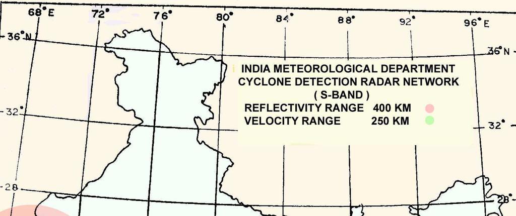
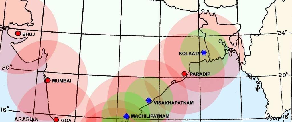
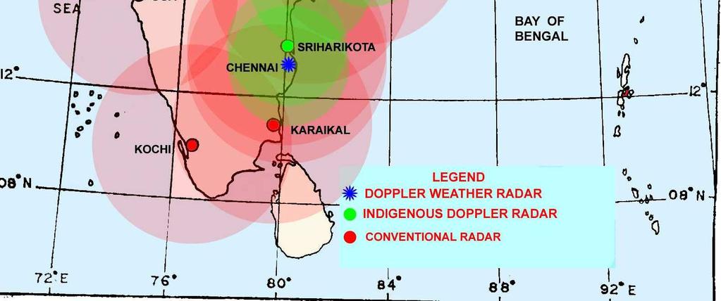
17 RBSN Bangladesh India Maldives Myanmar Pakistan Sri lanka Thailand
18
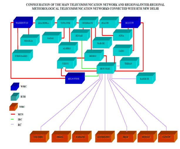
19 TELECOMMUNICATION NETWORK The automated centre of Regional Telecommunication Hub (RTH), New Delhi Principal Meteorological Telecommunication Centres in South Asia zone of responsibility extends roughly from Saudi Arabia in the west to Thailand in the East and the adjoining sea areas it maintains maintainstelecommunication Circuits with Moscow, Tokyo, Cairo, Jeddah, Bangkok, Colombo, Dhaka, Tehran, Karachi, Male, Yangon and Kathmandu. The circuit with Moscow and Beijing operates on 128 kbps speed, Dhaka, Pakistan, Jeddah, Cairo operates on 64 kbps, Melbourne, Male, Srilanka, Yangoon operates through Internet.
20
21 Telecommunication network
22 Cyclone Monitoring Recently, IMD has acquired the monitoring and prediction capabilities for these high impact weather events due to i. Installation of DWR ii. Augmentation of surface data due to AWS network iii. Availability of hourly AWS data iv. Increase in satellite derived products v. Installation and operationalisation of WRF model

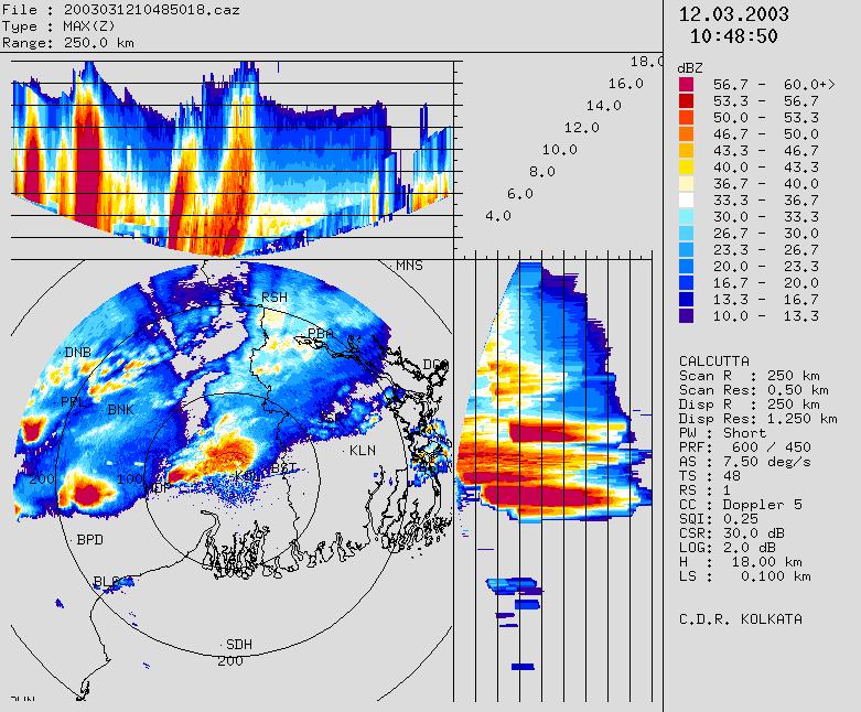
23 DWR at VSK
24 Met. Satellites of special relavance to TC analysis over NIO NOAA METEOSAT TRMM VIS and IR images from polar orbiting satellites have been in use in IMD since 1960s for TC analysis Dvorak s technique for intensity classification is used for north Indian Ocean since INSAT and Kalpana
25 Location of Centre: (a) Synoptic position: (b) Satellite: (1) INSAT/METSAT position (2) NOAA SSD: (c) Radar position : (d) Centre determined by other warning centres (e) Finally agreed official position (f) Confidence
26 Intensity estimation: (a) Satellite: (1)INSAT/METSAT (2)Intensity from NOAA SSD: (b) Radar (c) Synoptic analysis (d) Model analysis (e) Intensity determined by other warning centres (e) Finally agreed official intensity (f) Confidence
27 TROPICAL CYCLONE TRACK FORECASTING Track forecasting : i) Methods based on climatology (Analogs) ii) Methods based on Persistence & Climatology iii) Synoptic Techniques Empirical Techniques iv) Satellite Techniques v) Statistical Techniques (Chaos theory and Generic Algorithm method developed by SAC, Ahmedabad) vi) Analogue Techniques vii) NWP Models viii) Operational (Consensus) forecast
28 TROPICAL CYCLONE INTENSITY FORECASTING Subjective techniques like Climatology & Synoptic and Satellite (Dvorak) techniques are used. Dynamical statistical model NWP models have limitations
29 Existing NWP models for cyclone forecasting Models run in IMD/NCMRWF Global model of NCMRWF (T254 and T80) Regional Model (LAM and QLM) Meso-scale Model (MM5 and WRF) Model support from other Institutes IIT Delhi IAF Andhra University
30 Quasi-Lagrangian Model (QLM) A multilevel fine-mesh primitive equation model Resolution of 40 km and 16 sigma levels Merging of an idealized vortex into the initial Imposition of a steering current over the vortex area with the use of a dipole. The initial fields and lateral boundary conditions are derived based on global T254 forecasts ( NCMRWF, India). Run twice a day based on 00 UTC and 12 UTC initial conditions to provide 6 hourly track forecasts valid up to 72 hours.
31 Meso-scale Model MM-5 Daily once based on 00 UTC initial conditions for forecast upto 72 hours. Resolution 45 km with 23 sigma levels. Area between lat. 25.0o S to 45.0o N and long. 30o E to 120.0o E. NCEP analysis and six hourly forecasts are used as initial and boundary conditions During cyclone situations, the model is run by including Holland vortex scheme
32 Existing NWP models for cyclone forecasting International models used in IMD ECMWF UKMO JMA COLA
33 Bulletins issued by RSMC, New Delhi Tropical weather outlook : Once a day based on 0300 UTC observation Special tropical Weather Outlook : Twice a day based on 0300 and 1200 UTC observation during depression stage Tropical Cyclone Advisories : Every three hourly during cyclone period Issue of Tropical Cyclone Advisories for Aviation as per the guidelines of ICAO every six hourly during cyclone period
34 Tropical weather outlook The tropical weather outlook is prepared once daily. It is being transmitted at 06 UTC every day. The outlook includes only the general information like convection, position of ridge, formation of low pressure area etc An additional outlook is transmitted again over the GTS at 1700 UTC when a depression is located and expected to intensify into a cyclonic storm. When a system reaches the cyclonic storm stage (wind speed 34 kt), RSMC tropical cyclones, New Delhi in addition, issues cyclonic storm advisories.
35 TROPICAL CYCLONE ADVISORY When a system reaches the cyclonic storm stage, or is shortly expected to reach that intensity, RSMC tropical cyclones, New Delhi issues tropical cyclone advisories. Advisories are issued at 00, 03, 06, 09, 12, 15, 18 and 21 UTC. Tropical cyclone advisories contains information on the identification name, the present location, intensity and movement (present and past twelve hours) of the storm, and its forecast position, movement, intensity, maximum average surface wind, highest gust speed (upto 72 hrs) and sea conditions (in qualitative terms) and storm surge guidance. Important information obtained from radar observations and any relevant ship reports from the affected areas are repeated at the end of the advisory. Advisory contains physical reasoning on prognosis and diagnosis.
36 SPECIAL TROPICAL WEATHER OUTLOOK DEMS RSMC TROPICAL CYCLONES NEW DELHI TROPICAL WEATHER OUTLOOK FOR NORTH INDIAN OCEAN (THE BAY OF BENGAL AND ARABIAN SEA) VALID FOR NEXT 24 HOURS ISSUED AT 1000 UTC OF 14 APRIL, 2009 BASED ON 0900 UTC OF 14 APRIL, 2009 (.) THE LOW PRESSURE AREA OVER SOUTHEAST & ADJOINING CENTRAL BAY OF BENGAL CONCENTRATED INTO A DEPRESSION AND LAY CENTRED AT 0900 UTC OF TODAY, 14TH APRIL 2009 NEAR LAT DEG N AND LONG DEG E, ABOUT 550 KM WEST-NORTHWEST OF PORT BLAIR (43330), 700 KM SOUTHEAST OF VISAKHAPATNAM (43185) AND ABOUT 800 KM SOUTHWEST OF PATHEIN (48094) (MYANMAR). SATELLITE IMAGERY INDICATES GRADUAL ORGANISATION OF CONVECTION DURING PAST TWELVE HOURS. THE INTENSITY OF THE SYSTEM IS T1.5. ASSOCIATED BROKEN INTENSE TO VERY INTENSE CONVECTION OBSERVED OVER AREA BETWEEN LAT. 7.0 DEG N AND 16.0 DEG N AND LONG DEG. E AND 91.0 DEG. E. THE LOWEST CLOUD TOP TEMPERATURE (CTT) DUE TO CONVECTION IS AROUND -60 DEG C. (CONTD)
37 SPECIAL TROPICAL WEATHER OUTLOOK (contd) SUSTAINED MAXIMUM SURFACE WIND SPEED IS ESTIMATED TO BE ABOUT 25 KNOTS. THE STATE OF THE SEA IS ROUGH TO VERY ROUGH AROUND THE SYSTEM CENTRE. THE ESTIMATED CENTRAL PRESSURE IS ABOUT 1000 HPA. VERTICAL WIND SHEAR OF HORIZONTAL WIND OVER THE REGION IS AROUND 10 KNOTS. 24 HOURS SHEAR TENDENCY IS NEGTIVE TO THE WEST OF THE SYSTEM. THE SYSTEM LIES TO THE SOUTH OF THE UPPER TROPOSPHERIC RIDGE, WHICH ROUGHLY RUNS ALONG 150N. SEA SURFACE TEMPRATURES ARE FAVOURABLE FOR INTENSIFICATION AS IT IS 0.50 TO 1.00 C ABOVE NORMAL. CONSIDERING ALL THE ABOVE, THE SYSTEM IS LIKELY TO INTENSIFY FURTHER AND MOVE IN A NORTHWESTERLY DIRECTION. (M. MOHAPATRA) DIRECTOR TOO: HRS IST
38 TROPICAL CYCLONE ADVISORY FROM : RSMC TROPICAL CYCLONES, NEW DELHI TO : STORM WARNING CENTRE, DHAKA ( BANGLADESH ) STORM WARNING CENTRE, YANGAON (MYANMAR) STORM WARNING CENTRE, BANGKOK (THAILAND) STORM WARNING CENTRE, COLOMBO (SRILANKA) STORM WARNING CENTRE, KARACHI (PAKISTAN) METEOROLOGICAL OFFICE, MALE (MALDIVES) OMAN METEOROLOGICAL DEPARTMENT, MUSCAT (THROUGH RTH JEDDAH) TROPICAL CYCLONE ADVISORY RSMC TROPICAL CYCLONES, NEW DELHI TROPCAL STORM, BIJLI ADVISORY NO. ONE ISSUED AT 1500 UTC OF 15TH APRIL 2009 BASED ON 1200 UTC CHARTS OF 15TH APRIL THE DEEP DEPRESSION OVER CENTRAL & ADJOINING SOUTHEAST BAY OF BENGAL MOVED NORTHWESTWARDS, FURTHER INTENSIFIED INTO A CYCLONIC STORM, BIJLI AND LAY CENTRED AT 1200 UTC OF TODAY, THE 15TH APRIL 2009 NEAR LAT N AND LONG E, ABOUT 470 KM SOUTHEAST OF VISAKHAPATNAM, 750 KM NORTHWEST OF PORT BLAIR AND 900 KM SOUTHWEST OF PATHEIN (MYANMAR). THE SYSTEM IS LIKELY TO INTENSIFY FURTHER AND MOVE IN A NORTH-NORTHWESTERLY DIRECTION FOR SOME MORE TIME. (CONTD)
39 BASED ON THE LATEST ANALYSIS WITH NUMERICAL WEATHER PREDICTION (NWP) MODELS AND OTHER CONVENTIONAL TECHNIQUES, THE ESTIMATED FUTURE TRACK AND INTENSITY OF THE SYSTEM ARE GIVEN IN THE TABLE BELOW: DATE/TIME(UTC) POSITION (LAT. 0N/LONG. 0E) SUSTAINED MAXIMUM SURFACE WIND SPEED (KMPH) / / GUSTING TO / / GUSTING TO / / GUSTING TO / / GUSTING TO / / GUSTING TO / / GUSTING TO / / GUSTING TO 120 SUSTAINED MAXIMUM SURFACE WIND SPEED IS ESTIMATED TO BE ABOUT 40 KNOTS. THE STATE OF THE SEA IS VERY ROUGH TO HIGH AROUND THE SYSTEM CENTRE. THE ESTIMATED CENTRAL PRESSURE IS ABOUT 996 HPA. (CONTD)
40 SATELLITE IMAGERY SHOWS CURVED BAND PATTERN OF THE SYSTEM. ASSOCIATED BROKEN INTENSE TO VERY INTENSE CONVECTION IS SEEN OVER BAY OF BENGAL BETWEEN LAT N TO N AND WEST OF LONGITUDE 900 E. THE LOWEST CLOUD TOP TEMPERATURE (CTT) DUE TO CONVECTION IS AROUND -600C. THE INTENSITY OF THE SYSTEM IS T2.5 RPT T2.5. THE FORECAST INTENSITY DURING NEXT 24 HOURS IS T 3.0 VERTICAL WIND SHEAR OF HORIZONTAL WIND OVER THE REGION IS BETWEEN 5 TO 10 KNOTS. 24 HOURS SHEAR TENDENCY IS NEGATIVE TO THE NORTHWEST OF THE SYSTEM. THE SYSTEM LIES CLOSE TO SOUTH OF THE UPPER TROPOSPHERIC RIDGE, WHICH ROUGHLY RUNS ALONG 170N. CONSIDERING ALL THE ABOVE, THE SYSTEM IS LIKELY TO INTENSIFY FURTHER AND MOVE IN A NORTH-NORTHWESTERLY DIRECTION FOR SOME MORE TIME.
41 Storm surge guidance based on IIT Delhi model for WMO/ESCAP panel countries: STORM SURGE WITH HEIGHT OF ABOUT 2-3 METRES ABOVE ASTRONOMICAL TIDE IS LIKELY OVER BANGLADESH COAST NERA LANDFALL POINT AT THE TIME OF LANDFALL.
42 FROM: TROPICAL CYCLONE AVIATION CENTRE (TCAC), NEW DELHI TO : INTERNATIONAL AIRPORTS VIZ MUSCAT, KARACHI, ISLAMABAD, COLOMBO, YANGOON, DHAKA, SINGAPORE, KOLKATA, CHENNAI, MUMBAI, NEW DELHI. DTG : TCAC: TC: NR: PSN: MOV: C: Max Wind: FCST PSN +06Hrs: Max Wind + 06hrs: FCST PSN +12Hrs: Max Wind + 12hrs: FCST PSN +18Hrs: Max Wind + 18hrs: FCST PSN +24Hrs: Max Wind + 24hrs: NEXT MSG: /1200Z NEW DELHI BIJLI 01 N1500 E08630 NNW12KT 996HPA 40KT GUSTING TO 50KT N 1600 E KT GUSTING TO 50KT N 1630 E KT GUSTING TO 55KT N 1700 E KT GUSTING TO 55KT N 1730 E KT GUSTING TO 55KT /1800Z
43 New Initiatives in Cyclone Forecasting Timeliness of cyclone warnings All the bulletins/warnings is being issued within 2 hours of observations, which is an improvement in lead time available to disaster management agencies. Change in Format of Cyclone Warning Bulletin The format of bulletins has been changed with inclusion of forecast track and intensity at +6, +12, +18, +24, +36, +48, +60 and +72 hours. The cyclone warning bulletins containing the above information is being issued for the first time in the history of IMD since December The Sample copies of bulletins issued during AILA are enclosed (Appendix A).
44 Contd Inclusion of diagnosis and prognosis. The physical reasoning describing the diagnosis and prognosis of cyclonic disturbances over the north Indian Ocean is being mentioned in the RSMC bulletin. Prediction of Storm surge IIT Delhi Storm surge prediction model has been introduced operationally since RSMC, New Delhi is issuing storm surge guidance in its advisory bulletin to member countries with effect from Introduction of new cyclone forecasting system Improvement in forecast and research with respect to cyclones are likely with upgradation of forecasting activity through Modernisation of Indian Meteorological Observational Systems and Applications (MIMOSA)/ VARSAMANA Project.
45 Mean Forecast Error The mean forecast errors of RSMC, New Delhi based on data of last five years are given below. 12 hrs track forecast error 24 hrs track forecast error 87 km 139 km 12 hrs landfall point forecast error 24 hrs landfall point forecast error 72 km 81 km 12 hrs landfall time forecast error 24 hrs landfall time forecast error 24 hrs Intensity forecast error classification) 4 hrs 4 hrs T 0.5 (as per Dvorak
46 Upgradation of cyclone page of IMD website The present cyclone page includes following: Static information Frequently asked questions (FAQ ) Terminology Report of Cyclone disturbances over north India Ocean during Reports on latest Cyclone. TCP edition Dynamic information Bulletin for Indian Coast RSMC Bulletin Observed and forecast track QLM Track Satellite imagery Ocean state forecast
47 Cyclone Electronic Atlas 12 hourly data in cyclone electronic Atlas during has been published. Incorporates 3 Basins viz. Bay of Bengal, Arabian Sea and Land (India & Neighbouring countries) and 16 pre defined Coastal belts Can be installed in a personal desktop computer with Windows The eatlas generates three different types of output viz: Display of Tracks of C&Ds Statistical data of C&Ds in map form Tables / Bar diagrams Tracks can be saved and printed
48 Statistical Dynamical model for Cyclone genesis and intensity Prediction A statistical-dynamical model has been implemented for real time forecasting of cyclone genesis and intensity. The approach consists of (a) Analysis of Genesis Potential Parameter (GPP) and (b) 12 hourly Intensity Prediction for forecasts up to 72 hours. The model parameters are calibrated based on model analysis fields of past cyclones. For the real-time forecasting, model parameters are derived based on the forecast fields of MM5 model. The method is found to be promising for the operational use.
49 Research Forecasting Manual on Cyclone Implementation of WRF Model for cyclone prediction Introduction of MME technique for track prediction Storm surge prediction Cyclone prone districts of India Seasonal prediction of cyclonic disturbances over the north Indian Ocean Modulation of genesis and intensity of cyclonic disturbances by Madden Julian Oscillation Meteorological Monographs on characteristics of specific cyclones Individual research papers published in reviewed journals and proceedings of seminar/symposium Damage Potential
50 Publications Annual Report on Cyclonic Disturbances over the North Indian Ocean Annual cyclone review report Input for Panel News published by TSU, Pakistan Publication of best track digital data Meteorological Monographs Preliminary reports on Cyclones Cyclones over the north Indian Ocean have been individually documented and made available to public and research communities with effect from cyclone, Nargis
51 Training On cyclone warning to the WMO sponsored forecasters of various WMO/ESCAP Panel member countries since 2005 Conducts lecture series on cyclone warning during April and September, 2008 every year as a part of pre-cyclone exercise. A special lecture series was conducted during October 2008 for the benefit of the forecasters and researchers in HQ. Refresher courses are also conducted for the cyclone forecasters in regular intervals, especially for interpretation of satellite, radar and NWP products. A new forecasting system is being introduced in IMD with the collaboration of Meteo France International. The cyclone forecasters have undergone training this year in France on cyclone forecasting.
52 Role of RSMC New Delhi for storm surge prediction over the WMO/ESCAP Panel region. Till 2008, RSMC, New Delhi was issuing storm surge prediction for Indian coast only. Based on the recommendations of WMO Expert Team to Myanmar after Nargis and subsequent recommendation of WMO TCP, it has been decided to issue storm surge guidance to member countries based on IITD model. It has been implemented since 2009 with effect from cyclone, Bijli in April 2009.
53 Role of RSMC New Delhi for storm surge prediction over the WMO/ESCAP Panel region. It has further been decided that the IITD model will be installed in IMD, New Delhi and will be operationally run by IMD to issue storm surge guidance on real time basis to all the member countries
54 WMO Fact Finding Mission to Myanmar Yangoon,9-13 February 2009 Comprising of representatives and experts in tropical cyclone and storm surge forecasting and warning from WMO, ESCAP, India, Pakistan, Thailand familiarization of DMH staff and partners with WMO/ESCAP activities and potential opportunities for capacity development. The following presentations were made by the Indian expert during the Mission. Regional Specialised Meteorological Centre (Tropical Cyclone), New Delhi Review of cyclone Nargis Monitoring/tracking and advisory/warning services : RSMC New Delhi Regional services Standard operation procedure for Cyclone Warning Services In India Modernisation of forecasting system and disaster management Cyclone warning system. Cyclone e-atlas developed by IMD was installed and explained its usefulness.
55 Meteorological Data Dissemination IMD transmits processed imagery, meteorological and facsimile weather facility Through INSAT to the neighbouring countries The bulletins providing description of the cloud organization and coverage as advisory to forecasting offices every synoptic hour. During cyclones these bulletins are sent every hour.
56 Future prospects Modernisation programme of IMD 1. Forecasting and PWS 2. Satellite products 3. Doppler Weather Radars 4. Automatic Weather Stations (AWS) 5. Automatic Rain gauges (ARG) 6. Airport Modernization 7. Real Time Communication 8. High power computing system 9. Location specific forecast and now-casting
57 Numerical Models ( ) Global Model : T254/L64 (Resolution 65 km) upto 10 days for medium range forecast (MRF) and for regional model boundary conditions (Daily two runs). Meso-scale nested model for Regional domain at 6 hourly interval Local area nested model at Regional Centres at Res. 15/5 km Cyclone Model for Track Prediction at Res. 10 kms Storm Surge Model.
58 FORECAST DEMONSTRATION PROJECT ON LANDFALLING CYCLONES OBJECTIVE : COLLECT OBSERVATIONS IN THE TC CORE ENVIRONMENT USING RESEARCH AIRCRAFT AND UNMANNED AERIAL VEHICLE (UAV). DEMONSTRATE THE USE OF THE DROP SOUNDINGS AND UAV DATA IN PROVIDING IMPROVED NUMERICAL GUIDANCE FOR GENESIS, TRACK AND INTENSITY PREDICTION OF THE BAY OF BENGAL TROPICAL CYCLONE PROJECT SCHEDULE : PRE-PILOT PHASE : 15 OCT - 30 NOV 2008 PILOT PHASE : 15 OCT - 30 NOV Final PHASE : 15 OCT - 30 NOV REGION OF STUDY : BAY OF BENGAL
59 Forecast Demonstration Project (FDP) on landfalling Tropical Cyclones over the Bay of Bengal (Pre-Pilot phase 2008) Pre-pilot phase (15 Oct-30 Nov 2008) : Several national institutions participated for joint communicational & NWP activities. observational, Three Intense Observation Periods(IOP) were conducted association with the cyclones, Rashmi, Khai Muk and Nisha. in We have already requested all the member countries to participate in the programme. All the countries may participate in the programme
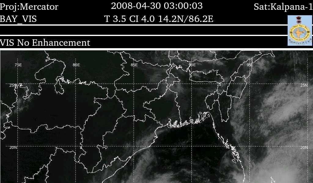
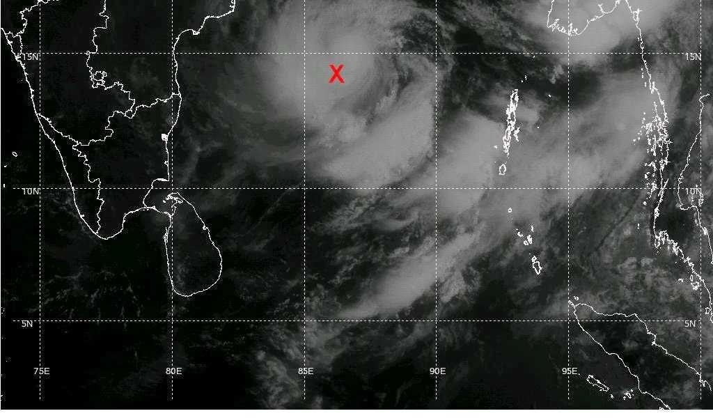
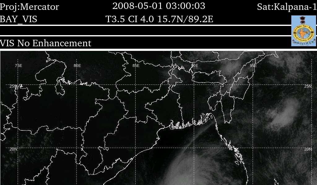
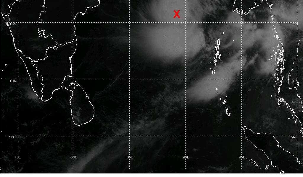
60 Proposed joint initiatives with IITD Modeling of Coastal area inundation due to cyclone Prediction of total water level (TWL) More specific prediction of storm surge due to cyclone. At present, the forecast is given for minimum unit area of district. Storm surge modeling for deltaic regions like, Sunderbans, Mahanadi delta and Cauvery delta. Preparation of Nomograms based on IITD model for different coastal belts of WMO/ESCAP region Probable maximum storm surge for different coastal belts of WMO/ESCAP region
61 Conclusion RSMC, New Delhi is well equipped for monitoring and prediction of cyclonic disturbances over the north Indian Ocean and storm surges over the WMO/ESCAP panel region. Improvement in accuracy of meteorological inputs has resulted in more accurate prediction of storm surge. With the completion of ongoing modernization programme, the error is likely to reduce by about % in next 2 years. It will further enable better storm surge prediction Further refinement of the storm surge model is essential especially for prediction of coastal area inundation and total water level and location specific storm surge IMD is willing to collaborate with IITD to achieve the objectives laid out by the workshop


62
63 Systems during 2008 NARGIS (27 April 3 May 2008) (Name proposed by Pakistan) RASHAMI(25-27 October 2008) (Name proposed by Sri Lanka) KHAI- MUK (13-16 November 2008) (Name proposed by Thailand) NISHA (25-27 November 2008) (Name proposed by Bangladesh)
64 Tracks of the cyclones during 2008
65 Accuracy and timeliness of the warnings


66 NARGIS
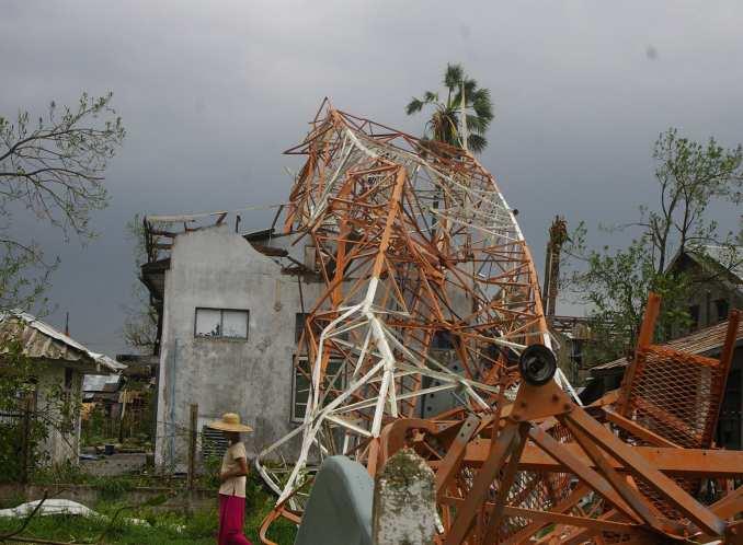
67 Very severe cyclonic storm NARGIS over the Bay of Bengal during 27 April to 3 May, 2008 The system continued to intensify even after the recurvature. The system moved almost in easterly direction from 0600 UTC of 1st May till 1500 UTC of 2nd May. The system maintained the intensity of very severe cyclonic storm for about 12 hrs after the landfall. It was the most devasting cyclone over the Bay of Bengal after Bangladesh cyclone of 1991 in term of loss of life and property as more than 1,38,000 people died due to this cyclone.


68 3004/03 UTC 0205/03 UTC 0105/03 UTC 0205/10 UTC

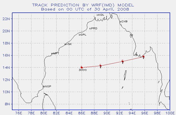
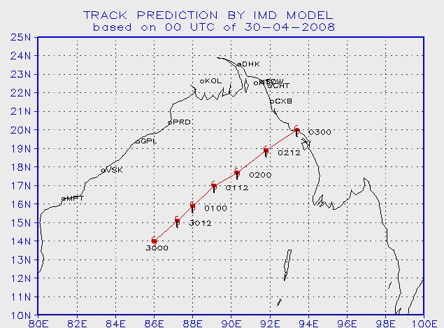
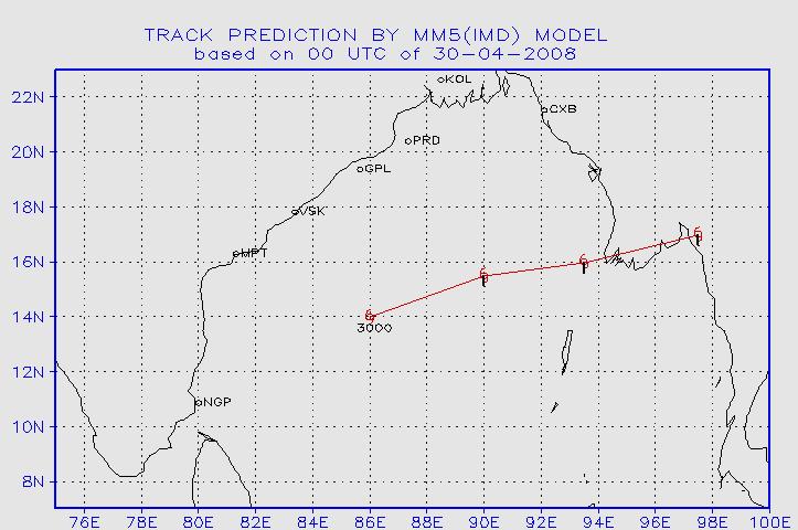
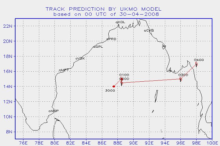
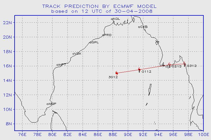
69 Track prediction by NWP models based on 30th April observations
70 24 HOURS TRACK F/C ERROR OF NARGIS BASED ON 2904/00 UTC IMD QLM ECMWF UKMO MM5 WRF(IMD) CLIPER MOG 24 HOURS TRACK F/C ERROR OF NARGIS BASED ON 3004/00 UTC G M O LI PE R C ) IM D F( W R M M 5 M O K U T2 54 F M W EC LM Q IM D 0
71 24 HOURS LANDFALL F/C ERROR OF NARGIS IMD QLM MM5 ECMWF UKMO WRF(IMD) MOG CLIPER 24 HOURS TIME ERROR OF NARGIS IMD QLM ECMWF UKMO -4-7 MM5-1 WRF(IMD) MOG CLIPER
72 Bulletins issued by RSMC, New Delhi during Nargis Tropical Weather Outlook 3 Tropical Cyclone Advisories 41 Tropical Cyclone Advisories for aviation use 19 The first tropical cyclone advisory indicating landfall over Myanmar coast was issued at 0600 UTC of 1ST May based on observations of 0300 UTC (about 36 hrs in advance). It was indicated in the bulletin that the system would cross Myanmar coast between lat 160 and 180 N around night of 2nd May On 2nd May morning, it was indicated that the system would cross Myanmar coast near 160N around evening of the same day.
73 Operational track, intensity and landfall forecast errors of NARGIS According to operational bulletin issued by Cyclone Warning Division/RSMC, New Delhi there is 64 Kms forecast average error in 12 hrs and 112 kms in 24 hrs. In 24 hrs predicted intensity forecast there is about T0.5 average error has noticed. Landfall error Point error Time error 12 hrs 55 kms 1 ½ hrs 24 hrs 110 kms 2 hrs 36 hrs 110 kms 3 ½ hrs
 261200 UTC")


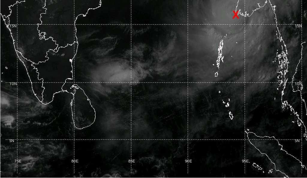
74 RASHMI(25-27 October 2008) UTC Cyclonic storm RASHMI crossed Bangladesh coast near long.89.5e about 50 kms west of Khepupara between UTC of 26th Oct
75 Cyclonic Storm RASHMI over the Bay of Bengal during October, 2008 It caused loss of life and property in Bangladesh and northeastern states, due to heavy rainfall and gale/squally winds The system intensified with increase in sustained wind speed reaching upto 45 knots just before the landfall. System rapidly weakened over land into a low pressure area (within 12 hrs) Three cyclonic storm (one each during 1905, 1967, 1988) with genesis over the region between or and have crossed Bangladesh coast during the period Storm surge of 6 feet has been reported at the time of landfall
76 Forecast tracks of NWP models based on 0000 UTC of 25th October 2008
77 Track predictions by WRF model (IITD)
78 INITIAL CONDITION: 24 OCT 08 ACTUAL LANDFALL : 21.8 N / 89.5 E at 2230 UTC / 26 OCT 08 GFS DATA T254 DATA Land Fall Error: km (W) / 1h30m (E) Land Fall Error: km (W) / 1h30m (D)
79 INITIAL CONDITION: 25 OCT 08 ACTUAL LANDFALL : 21.8 N / 89.5 E at 2230 UTC / 26 OCT 08 GFS DATA T254 DATA Land Fall Error: 24.60km (E) / 5h30m(E) Land Fall Error: 33.53km (E) / 1h30m (D)
80 INITIAL CONDITION: 26 OCT 08 ACTUAL LANDFALL : 21.8 N / 89.5 E at 2230 UTC / 26 OCT 08 GFS DATA T254 DATA Land Fall Error: km(W) / 4h30m(E) Land Fall Error: km(E) / 1h30m
81 24 HOURS LANDFALL F/C ERROR OF RASHMI IMD QLM ECMWF T254 UKMO MM5 GFS JMA CLIPER IAF IIT 24 HOURS TIME ERROR OF RASHMI IMD QLM -2 ECMWF T254 UKMO MM GFS JMA -1 CLIPER IAF -1.5 IIT
82 Intensity forecast Forecast for intensification into a cyclonic storm was first issued at : UTC Actual time of intensification into cyclonic storm : UTC Forecast of maximum intensity :T3.0 Base time for issue of maximum intensity : UTC Forecast wind speed at the time of landfall :40-50ktsGust 60kts along and off Bangladesh coast Base time for issue of maximum wind : UTC Qualitatively, the intensification of the system was predicted from :250300UTC.
83 Warnings/advisories issued by RSMC, New Delhi International bulletins : Special Ttropical Weather Outlook 5 RSMC Bulletin for Panel Member countries 06 Tropical Cyclone Advisories Centre (TCAC) Bulletin 03 National bulletins : Cyclone warning for Indian coast- 14


84 KHAI- MUK (13-16 November 2008) Cyclonic storm, KHAIMUK crossed Andhra Pradesh coast close to the north of Kavali between 2200 and 2300 UTC of 15th Nov 2008 as deep depression Caused heavy to very heavy rainfall over coastal Andhra Pradesh and Rayalaseema
85
86 KHAI MUK 24 HOURS TRACK ERROR (KM) BASED ON 1511/00 UTC IMD QLM ECMWF T254 MM5 CLIPER MOG IAF KHAIMUK LANDFALL F/C ERROR BASED ON 15/00 UTC QLM ECMWF 0 IMD T254 MM5 CLIPER MOG IAF IIT
87 KHAIMUK TIME F/C ERROR BASED ON 15/00 UTC QLM ECMWF T254 MM5 0-5 IMD CLIPER -3 MOG IAF -1.5 IIT
88 Warnings/advisories issued by RSMC, New Delhi International bulletins : Special Ttropical Weather Outlook 4 RSMC Bulletin for Panel Member countries 07 Tropical Cyclone Advisories Centre (TCAC) Bulletin 04 National bulletins : Cyclone warning for Indian coast- 21


89 Cyclonic storm NISHA Cyclonic storm NISHA over southwest Bay of Bengal moved very slowly and crossed Tamil Nadu and Puducherry coast, close to the north of Karaikal between 0530 and 0630 hrs IST of 27th. Scattered heavy to very heavy falls and isolated extremely heavy falls occurred over Tamil Nadu & Puducherry. It led to flood over the districts in delta regions and neighbourhood
90 Salient features of cyclone, NISHA There was loss of 78 human lives and caused huge crop loss. The salient features of cyclone, NISHA are as follows (i) The cyclogenesis took place over the land region(north Srilanka). (ii) System remained quasi-stationary for about 24 hours very close to the coast causing exceptionally heavy rainfall.
91 long= lat= fc= endhour=eof DRAW error: Syntax is DRAW WXSYM sym x y NWP models predictions based on 0000 UTC of 25 Nov 2008 siz <color <thick> > Query Error: Syntax is QUERY W2XY Lon Lat DRAW error: Invalid LINE coordinate DRAW error: Syntax is DRAW WXSYM sym x y siz <color <thick> NWP models predictions based on 0000 UTC of 26 Nov 2008
92 NISHA LANDFALL F/C ERROR BASED ON 26/00 UTC T254 UKMO 0 IMD QLM ECMWF MM5 IIT NISHA TIME ERROR BASED ON 26/00 UTC MM5 IIT IMD QLM ECMWF -3 T254 UKMO -1
93 Forecast error of IMD km Landfall error (km) of NISHA Time(UTC) Time error (hr) of NISHA hours Time(UTC)
94 Warnings/advisories issued by RSMC, New Delhi International bulletins : Special Ttropical Weather Outlook 3 RSMC Bulletin for Panel Member countries 07 Tropical Cyclone Advisories Centre (TCAC) Bulletin 04 National bulletins : Cyclone warning for Indian coast- 18
95 Bulletins Issued by Cyclone Warning Division during 2008 International Bulletins: Tropical weather outlook : Special weather outlook : Tropical cyclone Advisories : Tropical Cyclone Advisory Centre (TCAC) International civil aviation : National Bulletins: (i) Bulletins for Indian coast (ii) Bulletins issued by DGM : :
96 NARGIS Landfall error Point error Time error (i) 12 hrs landfall error 55 kms 1 ½ hrs (ii) 24 hrs landfall error 110 kms 2 hrs (iii) 36 hrs landfall error 110 kms 3 ½ hrs RASHMI Landfall error Point error Time error (i) 12 hrs landfall error 52 kms 2 hrs (ii) 24 hrs landfall error 21 kms 10 hrs KHAI MUK Landfall error Point error Time error (i) 12 hrs landfall error 20 kms 2 hrs (ii) 24 hrs landfall error 150 kms 12 hrs (iii) 36 hrs landfall error 150 kms 18 hrs NISHA Landfall error Point error Time error (i) 12 hrs landfall error 45 kms 8 hrs (ii) 24 hrs landfall error 100 kms 18 ½ hrs (iii) 36 hrs landfall error 150 kms 8 hrs Average Landfall error of cyclonic storms during 2008 Landfall error Point error Time error (i) 12 hrs landfall error 43 kms 3½ hrs (ii) 24 hrs landfall error 95 kms 10 ½ hrs (iii) 36 hrs landfall error 137 kms 10 hrs
97 AKASH (14-15 MAY 2007)2007) AKASH (14-15 MAY
98 GONU (02-07 JUN 2007)
99 TROPICAL STORM 03B (21-26 JUN 2007)
100 TROPICAL STORM 04B (28-29 JUN 2007)
101 TROPICAL STORM 05A (28 OCT-02 NOV 2007)
102 CYCLONE-4 SIDR (11-16 NOV 2007)
103 CYCLONE-4 NARGIS (27 APR-03 MAY 2008)
104 TROPICAL STORM TWO(16-16 SEP 2008)
105 TROPICAL STORM THREE(20-23 OCT 2008)
106 TROPICAL STORM RASHMI(26-27 OCT 2008)
107 TROPICAL STORM KHAI_MUK(14-16 NOV 2008)
108 TROPICAL STORM NISHA(25-27 NOV 2008)
109 TROPICAL STORM SEVEN (04-07 DEC 2008)
110 Thank you
ANNOUNCEMENT WMO/ESCAP PANEL ON TROPICAL CYCLONES THIRTY-EIGHTH SESSION NEW DELHI, INDIA
 WMO IMD ESCAP ANNOUNCEMENT THIRTY-EIGHTH SESSION NEW DELHI, INDIA (21-25 February 2011) HISTORICAL BACKGROUND The tropical cyclones are particularly severe in the north Indian Ocean region. The northern
Characteristics of Sudden Changes in Tropical Cyclone Tracks over North Indian Ocean. M. Mohapatra and B. K. Bandyopadhyay
 Characteristics of Sudden Changes in Tropical Cyclone Tracks over North Indian Ocean M. Mohapatra and B. K. Bandyopadhyay INDIA METEOROLOGICAL DEPARTMENT MAUSAM BHAVAN, LODI ROAD, NEW DELHI 110003 mohapatraimd@gmail.com
Government of Sultanate of Oman Public Authority of Civil Aviation Directorate General of Meteorology. National Report To
 Government of Sultanate of Oman Public Authority of Civil Aviation Directorate General of Meteorology National Report To Panel on Tropical Cyclones in the Bay of Bengal And Arabian Sea 43rd Session, India
Best track data of tropical cyclonic disturbances. over the north Indian Ocean. Regional Specialised Meteorological Centre (RSMC) -
 -") Best track data of tropical cyclonic disturbances over the north Indian Ocean Regional Specialised Meteorological Centre (RSMC) - Tropical Cyclones, New Delhi Cyclone Warning Division, India Meteorological
Best track data of tropical cyclonic disturbances over the north Indian Ocean Regional Specialised Meteorological Centre (RSMC) - Tropical Cyclones, New Delhi Cyclone Warning Division, India Meteorological
Tokyo, Japan March Discussed By: May Khin Chaw, Kyaw Lwin Oo. Department of Meteorology and Hydrology
 Tokyo, Japan 11-14 March 2014 Discussed By: May Khin Chaw, Kyaw Lwin Oo Department of Meteorology and Hydrology Manpower: Out of DMH s total (1425), we are Working with (780) Staffs. 55% (37) stations
DR RAJENDRA KUMAR JENAMANI
 TCAC NEW DELHI METHODS AND PROCEDURES USED FOR PREDICTION DR RAJENDRA KUMAR JENAMANI Director In-Charge Meteorological Watch Office (MWO) INDIA METEOROLOGICAL DEPARTMENT New ATS Building (Room No.-211,
EFFECTIVE TROPICAL CYCLONE WARNING IN BANGLADESH
 Country Report of Bangladesh On EFFECTIVE TROPICAL CYCLONE WARNING IN BANGLADESH Presented At JMA/WMO WORKSHOP ON EFFECTIVE TROPICAL CYCLONE WARNING IN SOUTHEAST ASIA Tokyo, Japan,11-14 March 2014 By Sayeed
ROLE OF INDIA METEOROLOGICAL DEPARTMENT IN MANAGEMENT OF METEOROLOGICAL HAZARDS IN INDIA M MOHAPATRA
 ROLE OF INDIA METEOROLOGICAL DEPARTMENT IN MANAGEMENT OF METEOROLOGICAL HAZARDS IN INDIA M MOHAPATRA INDIA METEOROLOGICAL DEPARTMENT NEW DELHI-110003 mohapatraimd@gmail.com Introduction Presentation layout
South Asian Climate Outlook Forum (SASCOF-12)
") Twelfth Session of South Asian Climate Outlook Forum (SASCOF-12) Pune, India, 19-20 April 2018 Consensus Statement Summary Normal rainfall is most likely during the 2018 southwest monsoon season (June
Twelfth Session of South Asian Climate Outlook Forum (SASCOF-12) Pune, India, 19-20 April 2018 Consensus Statement Summary Normal rainfall is most likely during the 2018 southwest monsoon season (June
TROPICAL CYCLONE TC 03A FOR THE PERIOD 3 RD JUNE TO 10 TH JUNE, 1998
 TROPICAL CYCLONE TC 03A FOR THE PERIOD 3 RD JUNE TO 10 TH JUNE, 1998 Hazrat Mir, Abdul Rashid, Waqarul Wheed Khan. Introduction: This report gives the review of cyclonic storm formed over the East Arabian
South Asian Climate Outlook Forum (SASCOF-6)
") Sixth Session of South Asian Climate Outlook Forum (SASCOF-6) Dhaka, Bangladesh, 19-22 April 2015 Consensus Statement Summary Below normal rainfall is most likely during the 2015 southwest monsoon season
Sixth Session of South Asian Climate Outlook Forum (SASCOF-6) Dhaka, Bangladesh, 19-22 April 2015 Consensus Statement Summary Below normal rainfall is most likely during the 2015 southwest monsoon season
UPDATE OF REGIONAL WEATHER AND SMOKE HAZE (December 2017)
") UPDATE OF REGIONAL WEATHER AND SMOKE HAZE (December 2017) 1. Review of Regional Weather Conditions for November 2017 1.1 In November 2017, Southeast Asia experienced inter-monsoon conditions in the first
UPDATE OF REGIONAL WEATHER AND SMOKE HAZE (December 2017) 1. Review of Regional Weather Conditions for November 2017 1.1 In November 2017, Southeast Asia experienced inter-monsoon conditions in the first
Presentation on RSMC Nadi-TCC Activities
 6 th TC RSMC Technical Coordination Meeting, Brisbane, Australia, 2 5 Nov 2009 Presentation on RSMC Nadi-TCC Activities R. Prasad Director RSMC Nadi-TCC NADI TROPICAL CYCLONE CENTRE RSMC NADI - TCC Approved
Long Range Forecasts of 2015 SW and NE Monsoons and its Verification D. S. Pai Climate Division, IMD, Pune
 Long Range Forecasts of 2015 SW and NE Monsoons and its Verification D. S. Pai Climate Division, IMD, Pune Other Contributors: Soma Sen Roy, O. P. Sreejith, Kailas, Madhuri, Pallavi, Mahendra and Jasmine
CYCLONE LAILA RED WARNING. May 19, 2010 (23.45 hrs)
") CYCLONE LAILA RED WARNING May 19, 2010 (23.45 hrs) The severe cyclonic storm LAILA over westcentral and adjoining southwest Bay of Bengal remained practically stationary and lay centred at 2030 hrs IST
CYCLONE LAILA RED WARNING May 19, 2010 (23.45 hrs) The severe cyclonic storm LAILA over westcentral and adjoining southwest Bay of Bengal remained practically stationary and lay centred at 2030 hrs IST
International Journal of Integrated Sciences & Technology 2 (2016) 55-61
 55-61") International Journal of Integrated Sciences & Technology 2 (2016) 55-61 Changes in Latent Heat Energy and Moist Static Energy Contents of the Atmosphere over Bangladesh and Neighbourhood during the Formation
International Journal of Integrated Sciences & Technology 2 (2016) 55-61 Changes in Latent Heat Energy and Moist Static Energy Contents of the Atmosphere over Bangladesh and Neighbourhood during the Formation
Regional Seminar on Aviation Meteorology Service in Asia Beijing, China (11-15 April 2011)
") Regional Seminar on Aviation Meteorology Service in Asia Beijing, China (11-15 April 2011) Aviation Meteorology Service in Myanmar Mr.Hla Shwe Staff Officer Department of Meteorology and Hydrology Myanmar
Regional Seminar on Aviation Meteorology Service in Asia Beijing, China (11-15 April 2011) Aviation Meteorology Service in Myanmar Mr.Hla Shwe Staff Officer Department of Meteorology and Hydrology Myanmar
South Asian Climate Outlook Forum (SASCOF-8)
") Eighth Session of South Asian Climate Outlook Forum (SASCOF-8) Colombo, Sri Lanka, 25-26 April 2016 Consensus Statement Summary Above-normal rainfall is most likely during the 2016 southwest monsoon season
Eighth Session of South Asian Climate Outlook Forum (SASCOF-8) Colombo, Sri Lanka, 25-26 April 2016 Consensus Statement Summary Above-normal rainfall is most likely during the 2016 southwest monsoon season
COORDINATION WITH OTHER ACTIVITIES OF THE WMO TROPICAL CYCLONE PROGRAMME. (Submitted by the WMO Secretariat) Summary and Purpose of Document
 Summary and Purpose of Document") ESCAP/WMO TYPHOON COMMITTEE FORTY-NINTH SESSION 21-24 FEBRUARY 2017 YOKOHAMA, JAPAN FOR PARTICIPANTS ONLY WRD/TC.49/16 13 February 2017 ENGLISH ONLY COORDINATION WITH OTHER ACTIVITIES OF THE WMO TROPICAL
ESCAP/WMO TYPHOON COMMITTEE FORTY-NINTH SESSION 21-24 FEBRUARY 2017 YOKOHAMA, JAPAN FOR PARTICIPANTS ONLY WRD/TC.49/16 13 February 2017 ENGLISH ONLY COORDINATION WITH OTHER ACTIVITIES OF THE WMO TROPICAL
1. Introduction. 2. Verification of the 2010 forecasts. Research Brief 2011/ February 2011
 Research Brief 2011/01 Verification of Forecasts of Tropical Cyclone Activity over the Western North Pacific and Number of Tropical Cyclones Making Landfall in South China and the Korea and Japan region
UPDATE OF REGIONAL WEATHER AND SMOKE HAZE (February 2018)
") UPDATE OF REGIONAL WEATHER AND SMOKE HAZE (February 2018) 1. Review of Regional Weather Conditions for January 2018 1.1 The prevailing Northeast monsoon conditions over Southeast Asia strengthened in January
UPDATE OF REGIONAL WEATHER AND SMOKE HAZE (February 2018) 1. Review of Regional Weather Conditions for January 2018 1.1 The prevailing Northeast monsoon conditions over Southeast Asia strengthened in January
(April 7, 2010, Wednesday) Tropical Storms & Hurricanes Part 2
 Tropical Storms & Hurricanes Part 2") Lecture #17 (April 7, 2010, Wednesday) Tropical Storms & Hurricanes Part 2 Hurricane Katrina August 2005 All tropical cyclone tracks (1945-2006). Hurricane Formation While moving westward, tropical disturbances
Lecture #17 (April 7, 2010, Wednesday) Tropical Storms & Hurricanes Part 2 Hurricane Katrina August 2005 All tropical cyclone tracks (1945-2006). Hurricane Formation While moving westward, tropical disturbances
Summary. peninsula. likely over. parts of. Asia has. have now. season. There is. season, s that the. declining. El Niño. affect the. monsoon.
 Eighth Session of South Asian Climate Outlook Forum (SASCOF-8) Colombo, Sri Lanka, 25-26 April 2016 Consensus Statement Summary Above-normal rainfalll is likely during the 2016 southwest monsoon season
Application of Satellite Data for Flood Forecasting and Early Warning in the Mekong River Basin in South-east Asia
 MEKONG RIVER COMMISSION Vientiane, Lao PDR Application of Satellite Data for Flood Forecasting and Early Warning in the Mekong River Basin in South-east Asia 4 th World Water Forum March 2006 Mexico City,
Seasonal Climate Outlook for South Asia (June to September) Issued in May 2014
 Issued in May 2014") Ministry of Earth Sciences Earth System Science Organization India Meteorological Department WMO Regional Climate Centre (Demonstration Phase) Pune, India Seasonal Climate Outlook for South Asia (June
Ministry of Earth Sciences Earth System Science Organization India Meteorological Department WMO Regional Climate Centre (Demonstration Phase) Pune, India Seasonal Climate Outlook for South Asia (June
Current Details from the Joint Typhoon Warning Center
 Current Details from the Joint Warning Center COORDINATES: 19.6 north, 125.5 east (previous location: 17.9 north, 130.3 east) LOCATION: 737 kilometers (458 miles) southeast of Taipei, Taiwan MOVEMENT:
Coastal Inundation Forecasting and Community Response in Bangladesh
 WMO Coastal Inundation Forecasting and Community Response in Bangladesh Bapon (SHM) Fakhruddin Nadao Kohno 12 November 2015 System Design for Coastal Inundation Forecasting CIFDP-PSG-5, 14-16 May 2014,
W O R L D M E T E O R O L O G I C A L O R G A N I Z A T I O N T E C H N I C A L D O C U M E N T. WMO/TD No. 84
 W O R L D M E T E O R O L O G I C A L O R G A N I Z A T I O N T E C H N I C A L D O C U M E N T WMO/TD No. 84 TROPICAL CYCLONE PROGRAMME Report No. TCP-21 TROPICAL CYCLONE OPERATIONAL PLAN FOR THE BAY
Indian Ocean Forecast System (INDOFOS) Abhisek Chatterjee
 Abhisek Chatterjee") Indian Ocean Forecast System (INDOFOS) Abhisek Chatterjee Earth System Sciences Organisation (ESSO) Indian National Centre for Ocean Information Services (INCOIS) Ministry of Earth Sciences, Government
Indian Ocean Forecast System (INDOFOS) Abhisek Chatterjee Earth System Sciences Organisation (ESSO) Indian National Centre for Ocean Information Services (INCOIS) Ministry of Earth Sciences, Government
Prediction of western disturbances and associated weather over Western Himalayas
 Prediction of western disturbances and associated weather over Western Himalayas H. R. Hatwar*, B. P. Yadav and Y. V. Rama Rao India Meteorological Department, Lodi Road, New Delhi 110 003, India Two cases
M. Mohapatra and D. R. Pattanaik
 Understanding and forecasting of intra-seasonal extremes of southwest monsoon circulation and precipitation over India M. Mohapatra and D. R. Pattanaik IMD, New Delhi Email : m.mohapatra@imd.gov.in Annual
Joint Meeting of RA II WIGOS Project and RA V TT-SU on 11 October 2018 BMKG Headquarter Jakarta, Indonesia. Mrs. Sinthaly CHANTHANA
 Joint Meeting of RA II WIGOS Project and RA V TT-SU on 11 October 2018 BMKG Headquarter Jakarta, Indonesia Mrs. Sinthaly CHANTHANA Lao PDR Background Department of Meteorology and Hydrology ( DMH ) in
Country Report of Bangladesh On
 Country Report of Bangladesh On EFFECTIVE TROPICAL CYCLONE WARNING IN BANGLADESH Presented At JMA/WMO WORKSHOP ON EFFECTIVE TROPICAL CYCLONE WARNING IN SOUTHEAST ASIA Tokyo, Japan 11-14 March 2014 By Sayeed
JMA/WMO WORKSHOP ON EFFECTIVE TROPICAL CYCLONE WARNING IN SOUTHEAST ASIA
 JMA/WMO WORKSHOP ON EFFECTIVE TROPICAL CYCLONE WARNING IN SOUTHEAST ASIA TROPICAL CYCLONE MONITORING IN LAO PDR TOKYO, JAPAN 11 14 March 2014 Ministry of Natural Resource and Environment (MONRE) Department
WMO s Severe Weather Forecasting Demonstration Project (SWFDP)
") 5 th Meeting of the RA II WIGOS Project on Satellites Coordination Group, 21 Oct 2017 WMO s Severe Weather Forecasting Demonstration Project (SWFDP) Abdoulaye Harou Chief DPFS Division/WDS WMO Secretariat
5 th Meeting of the RA II WIGOS Project on Satellites Coordination Group, 21 Oct 2017 WMO s Severe Weather Forecasting Demonstration Project (SWFDP) Abdoulaye Harou Chief DPFS Division/WDS WMO Secretariat
COUNTRY PRESENTATION ON MR JAYNAL ABEDIN JOINT SECRETARY ( WORKS & DEVELOPMENT ) MINISTRY OF DEFENCE
 MINISTRY OF DEFENCE") COUNTRY PRESENTATION ON By MR JAYNAL ABEDIN JOINT SECRETARY ( WORKS & DEVELOPMENT ) MINISTRY OF DEFENCE Bangladesh Geographical Location of Bangladesh Bangladesh Country at a Glance Physical Features 1,230
COUNTRY PRESENTATION ON By MR JAYNAL ABEDIN JOINT SECRETARY ( WORKS & DEVELOPMENT ) MINISTRY OF DEFENCE Bangladesh Geographical Location of Bangladesh Bangladesh Country at a Glance Physical Features 1,230
JICA s Cooperation for NMHSs. Taisuke Watanabe Japan International Cooperation Agency
 JICA s Cooperation for NMHSs Taisuke Watanabe 28 Oct, 2014 JICA s Assistant Approach for Hydrological and Meteorological Services Assistance for improvement of Hydrological and Meteorological Services
NUMERICAL SIMULATION OF A BAY OF BENGAL TROPICAL CYCLONE: A COMPARISON OF THE RESULTS FROM EXPERIMENTS WITH JRA-25 AND NCEP REANALYSIS FIELDS
 NUMERICAL SIMULATION OF A BAY OF BENGAL TROPICAL CYCLONE: A COMPARISON OF THE RESULTS FROM EXPERIMENTS WITH JRA-25 AND NCEP REANALYSIS FIELDS Dodla Venkata Bhaskar Rao Desamsetti Srinivas and Dasari Hari
Ryuji Yamada Tokyo Climate Center Japan Meteorological Agency E mail: URL:
 Ryuji Yamada Tokyo Center Japan Meteorological Agency E mail: tcc@met.kishou.go.jp URL: http://ds.data.jma.go.jp/tcc/tcc/index.html Tokyo Center (TCC) Established in April 2002 at JMA to support climate
Overview of existing Weather Forecasting and Warning infrastructures in Myanmar
 Overview of existing Weather Forecasting and Warning infrastructures in Myanmar by Dr. Zin Mie Mie Sein Officer (DMH) 26. February. 2018 Nay Pyi Taw Outline Introduction Myanmar & its disasters Meteorological
Cyclone forecasting and its constrains for the Bay of Bengal
 Annex IV JMA/WMO WORKSHOP ON EFFECTIVE TROPICAL CYCLONE WARNING IN SOUTHEAST ASIA Tokyo, Japan 11-14 March 2014 Cyclone forecasting and its constrains for the Bay of Bengal Submitted by Kawsar Parvin Meteorologist
Analysis on MM5 predictions at Sriharikota during northeast monsoon 2008
 Analysis on MM5 predictions at Sriharikota during northeast monsoon 8 D Gayatri Vani, S Rambabu, M Rajasekhar, GVRama, B V Apparao and A K Ghosh MET-Facility, Satish Dhawan Space Centre, SHAR, ISRO, Sriharikota
W O R L D M E T E O R O L O G I C A L O R G A N I Z A T I O N T E C H N I C A L D O C U M E N T. WMO/TD No. 84
 W O R L D M E T E O R O L O G I C A L O R G A N I Z A T I O N T E C H N I C A L D O C U M E N T WMO/TD No. 84 TROPICAL CYCLONE PROGRAMME Report No. TCP-21 TROPICAL CYCLONE OPERATIONAL PLAN FOR THE BAY
T-PARC and TCS08 (Submitted by Pat Harr, Russell Elsberry and Tetsuo Nakazawa)
") WORLD METEOROLOGICAL ORGANIZATION COMMISSION FOR ATMOSPHERIC SCIENCES INTERNATIONAL CORE STEERING COMMITTEE FOR THORPEX Eighth Session DWD, Offenbach (2 4 November 2009) CAS/ICSC-8/DOC4.1 (3 X.2009) Item:
WORLD METEOROLOGICAL ORGANIZATION COMMISSION FOR ATMOSPHERIC SCIENCES INTERNATIONAL CORE STEERING COMMITTEE FOR THORPEX Eighth Session DWD, Offenbach (2 4 November 2009) CAS/ICSC-8/DOC4.1 (3 X.2009) Item:
Meteorological Hazards and Current Approach to Observing, Modelling and Predicting Severe Events in Sri Lanka
 Regional Workshop on Impact-based Forecasts in RA II (Asia) 7-9, November, 2017, Seoul, Republic of Korea Meteorological Hazards and Current Approach to Observing, Modelling and Predicting Severe Events
Saiful Islam Anisul Haque
 Workshop on Disaster Prevention/Mitigation Measures against Floods and Storm Surges in Bangladesh on 17-21 November, 2012, in Kyoto University, Japan Component 2: Flood disaster risk assessment and mitigation
Estimation of pressure drop and storm surge height associated to tropical cyclone using Doppler velocity
 Indian Journal of Radio & Space Physics Vol 41, June 2012, pp 348-358 Estimation of pressure drop and storm surge height associated to tropical cyclone using Doppler velocity Devendra Pradhan 1,$,*, Anasuya
WMO LC-LRFMME and Seasonal Climate Outlook for ONDJFM 2015/16
 WMO Lead Centre for Long-Range Forecast Multi-Model Ensemble WMO LC-LRFMME and Seasonal Climate Outlook for ONDJFM 2015/16 Daeun Jeong and WMO LC-LRFMME team The Winter South Asian Climate Outlook Forum
KUALA LUMPUR MONSOON ACTIVITY CENT
 T KUALA LUMPUR MONSOON ACTIVITY CENT 2 ALAYSIAN METEOROLOGICAL http://www.met.gov.my DEPARTMENT MINISTRY OF SCIENCE. TECHNOLOGY AND INNOVATIO Introduction Atmospheric and oceanic conditions over the tropical
COUNTRY REPORT. Jakarta. July, th National Directorate of Meteorology and Geophysics of Timor-Leste (DNMG)
") The Southeastern Asia-Oceania Flash Flood COUNTRY REPORT Jakarta. July, 10-12 th 2017 National Directorate of Meteorology and Geophysics of Timor-Leste (DNMG) Carla Feritas and Crisostimo Lobato Democratic
The Southeastern Asia-Oceania Flash Flood COUNTRY REPORT Jakarta. July, 10-12 th 2017 National Directorate of Meteorology and Geophysics of Timor-Leste (DNMG) Carla Feritas and Crisostimo Lobato Democratic
UPDATE OF REGIONAL WEATHER AND SMOKE HAZE (May 2017)
") UPDATE OF REGIONAL WEATHER AND SMOKE HAZE (May 2017) 1. Review of Regional Weather Conditions in April 2017 1.1 Inter monsoon conditions, characterised by afternoon showers and winds that are generally
UPDATE OF REGIONAL WEATHER AND SMOKE HAZE (May 2017) 1. Review of Regional Weather Conditions in April 2017 1.1 Inter monsoon conditions, characterised by afternoon showers and winds that are generally
JCOMM-CHy Coastal Inundation Forecasting Demonstration Project (CIFDP)
") WMO World Meteorological Organization Working together in weather, climate and water JCOMM-CHy Coastal Inundation Forecasting Demonstration Project (CIFDP) Coastal Flooding & Vulnerable Populations Coastal
WMO World Meteorological Organization Working together in weather, climate and water JCOMM-CHy Coastal Inundation Forecasting Demonstration Project (CIFDP) Coastal Flooding & Vulnerable Populations Coastal
7 December 2016 Tokyo Climate Center, Japan Meteorological Agency
 Summary of the 2016 Asian Summer Monsoon 7 December 2016 Tokyo Climate Center, Japan Meteorological Agency This report summarizes the characteristics of the surface climate and atmospheric/oceanographic
Issued by the: Climate Services Division Fiji Meteorological Service Nadi Airport. 27 October 2010 GENERAL STATEMENT
 Fiji Meteorological Service (FMS) Tropical Cyclone Guidance for Season 2010/11 for the Fiji and the Southwest Pacific RSMC Region 160E to 120W Equator to 25 South Issued by the: Climate Services Division
Impact of Tropical Cyclones - Malaysia's Experience
 Impact of Tropical Cyclones - Malaysia's Experience ALUI BAHARI MALAYSIAN METEOROLOGICAL DEPARTMENT MINISTRY OF SCIENCE, TECHNOLOGY AND INNOVATION SCOPE Introduction Case Studies of Tropical Cyclones Impacting
Current Details from the Joint Typhoon Warning Center
 Current Details from the Joint Warning Center COORDINATES: 10.2 north, 148.1 east (previous location: 10.1 north, 148.3 east) LOCATION: 520 kilometers (325 miles) southeast of Andersen Air Force Base,
Verification of the Seasonal Forecast for the 2005/06 Winter
 Verification of the Seasonal Forecast for the 2005/06 Winter Shingo Yamada Tokyo Climate Center Japan Meteorological Agency 2006/11/02 7 th Joint Meeting on EAWM Contents 1. Verification of the Seasonal
10 emergency observation requests were successfully processed during the period
 ISRO s Inputs for the Sentinel Asia DPN and JPT meeting being held during 13-16, 16, November 2012 November 2012 Sentinel Asia Activity Spectrum - A dedicated Sentinel Asia server established at NRSC,
Earth Observation & forecasting Storm Surges in the North Western Pacific. Mr. Nadao Kohno Japan Meteorological Agency
 Earth Observation & forecasting Storm Surges in the North Western Pacific Mr. Nadao Kohno Japan Meteorological Agency Lesson Outline Introduction JMA s responsibility and work as a RSMC, Tokyo Typhoon
Recent Developments of JMA Operational NWP Systems and WGNE Intercomparison of Tropical Cyclone Track Forecast
 Recent Developments of JMA Operational NWP Systems and WGNE Intercomparison of Tropical Cyclone Track Forecast Chiashi Muroi Numerical Prediction Division Japan Meteorological Agency 1 CURRENT STATUS AND
Evidence for Weakening of Indian Summer Monsoon and SA CORDEX Results from RegCM
 Evidence for Weakening of Indian Summer Monsoon and SA CORDEX Results from RegCM S K Dash Centre for Atmospheric Sciences Indian Institute of Technology Delhi Based on a paper entitled Projected Seasonal
2014/2/25. Earth Observation & forecasting Storm Surges in the North Western Pacific. Lesson Outline. RSMC Tokyo Typhoon Center.
 Earth Observation & forecasting Storm Surges in the North Western Pacific Mr. Nadao Kohno Japan Meteorological Agency Lesson Outline Introduction JMA s responsibility and work as a RSMC, Tokyo Typhoon
Government of Sultanate of Oman Public Authority of Civil Aviation Directorate General of Meteorology. National Report To
 Government of Sultanate of Oman Public Authority of Civil Aviation Directorate General of Meteorology National Report To Panel on Tropical Cyclones in the Bay of Bengal And Arabian Sea 45 th Session, Muscat,
CURRENT STATUS OF MONSOON Main Meteorological conditions of the last week (27August to 2 September)
") CURRENT STATUS OF MONSOON 2009 Main Meteorological conditions of the last week (27August to 2 September) Last week s low pressure area over Orissa and neighbourhood moved west-northwestwards across central
CURRENT STATUS OF MONSOON 2009 Main Meteorological conditions of the last week (27August to 2 September) Last week s low pressure area over Orissa and neighbourhood moved west-northwestwards across central
Development of Tropical Storm Falcon (Meari) over the Philippines
 over the Philippines") Development of Tropical Storm Falcon (Meari) over the Philippines June 20-27, 2011 At the end of June, 2011, the Philippines were struck again by Tropical storm Falcon (Meari). After gaining strength over
Development of Tropical Storm Falcon (Meari) over the Philippines June 20-27, 2011 At the end of June, 2011, the Philippines were struck again by Tropical storm Falcon (Meari). After gaining strength over
Tropical Storm List
 Tropical Storm Email List http://tstorms.org/ tropical-storms@tstorms.org Tropical-Storms is a mailing list only for those who are professionally active in either the research or forecasting of tropical
PRE MONSOON TROPICAL CYCLONE ALERT (LAILA)
") PRE MONSOON TROPICAL CYCLONE ALERT (LAILA) (Updated as on 19 th May, 2010, 10.00 AM) A pre-monsoon Tropical Cyclone alert has been issued for all the coastal districts of Orissa by the Special Relief Commissioner
PRE MONSOON TROPICAL CYCLONE ALERT (LAILA) (Updated as on 19 th May, 2010, 10.00 AM) A pre-monsoon Tropical Cyclone alert has been issued for all the coastal districts of Orissa by the Special Relief Commissioner
Sixth Session of the ASEAN Climate Outlook Forum (ASEANCOF-6)
") Sixth Session of the ASEAN Climate Outlook Forum (ASEANCOF-6) Consensus Bulletin for June-July-August 2016 Season Introduction The Sixth ASEAN Climate Outlook Forum (ASEANCOF-6) was organised by the Philippine
Sixth Session of the ASEAN Climate Outlook Forum (ASEANCOF-6) Consensus Bulletin for June-July-August 2016 Season Introduction The Sixth ASEAN Climate Outlook Forum (ASEANCOF-6) was organised by the Philippine
Reduction of the Radius of Probability Circle. in Typhoon Track Forecast
 Reduction of the Radius of Probability Circle in Typhoon Track Forecast Nobutaka MANNOJI National Typhoon Center, Japan Meteorological Agency Abstract RSMC Tokyo - Typhoon Center of the Japan Meteorological
Long Range Forecast Update for 2014 Southwest Monsoon Rainfall
 Earth System Science Organization (ESSO) Ministry of Earth Sciences (MoES) India Meteorological Department PRESS RELEASE New Delhi, 9 June 2014 Long Update for 2014 Southwest Monsoon Rainfall HIGHLIGHTS
R.C.BHATIA, P.N. Khanna and Sant Prasad India Meteorological Department, Lodi Road, New Delhi ABSTRACT
 Improvements in Automated Cloud Motion Vectors ---------------------------------------------- (CMVs) derivation scheme using INSAT VHRR data. ---------------------------------------------- by R.C.BHATIA,
Thai Meteorological Department, Ministry of Digital Economy and Society
 Thai Meteorological Department, Ministry of Digital Economy and Society Three-month Climate Outlook For November 2017 January 2018 Issued on 31 October 2017 -----------------------------------------------------------------------------------------------------------------------------
Coastal Inundation Forecasting Demonstration Project (CIFDP)
") WMO World Meteorological Organization Working together in weather, climate and water Coastal Inundation Forecasting Demonstration Project (CIFDP) WMO Technical Commission for Oceanography and Marine Meteorology
WMO World Meteorological Organization Working together in weather, climate and water Coastal Inundation Forecasting Demonstration Project (CIFDP) WMO Technical Commission for Oceanography and Marine Meteorology
Development of JMA storm surge model
 2 nd JCOMM Scientific and Technical Symposium on Storm Surges 8-13 November 2015, Key West, Florida, USA Development of JMA storm surge model Hiroshi HASEGAWA (h_hasegawa@met.kishou.go.jp) Office of Marine
Update on SCOPE-Nowcasting Pilot Project Real Time Ocean Products Suman Goyal Scientist-E
 Update on SCOPE-Nowcasting Pilot Project Real Time Ocean Products Suman Goyal Scientist-E 19-22 Nov 2013 SCOPE-Nowcasting-1 Agenda Item 5 Pilot Projects Overview Users /Clients User requirements Product
Weather Forecasting in Flood Forecasting Activities
 Weather Forecasting in Flood Forecasting Activities Eugene Poolman South African Weather Service Representing CBS Pretoria South Africa FCAST PRES 20130919 001 Main Activities of CBS Development, implementation
WMO Global Data-Processing and Forecasting System Operational weather forecast product delivery relevant to SDSWS
 WMO Global Data-Processing and Forecasting System Operational weather forecast product delivery relevant to SDSWS Peter Chen World Weather Watch Department, WMO WMO/GEO Expert Meeting for an International
UPDATE OF REGIONAL WEATHER AND SMOKE HAZE (September 2017)
") UPDATE OF REGIONAL WEATHER AND SMOKE HAZE (September 2017) 1. Review of Regional Weather Conditions in August 2017 1.1 Southwest Monsoon conditions continued to prevail in the region in August 2017. The
UPDATE OF REGIONAL WEATHER AND SMOKE HAZE (September 2017) 1. Review of Regional Weather Conditions in August 2017 1.1 Southwest Monsoon conditions continued to prevail in the region in August 2017. The
TONGA COUNTRY REPORT. Officer : John Holi
 TONGA COUNTRY REPORT Officer : John Holi OUTLINES INTRODUCTION BACKGROUND INFORMATION CLIMATE TONGA METEOROLOGICAL SERVICE PROPOSAL INTRODUCTION Location of Tonga Lies between 15 173 W 155 177 W 25.55
Shuhei Maeda Climate Prediction Division Global Environment and Marine Department Japan Meteorological Agency
 Eighth Session of the Forum on Regional Climate Monitoring, Assessment and Prediction for Asia (FOCRAII) 5-7 April 2012, Beijing, China Shuhei Maeda Climate Prediction Division Global Environment and Marine
Applications of Space Technology and GIS for Disaster Risk Reduction and Sustainable Development in Myanmar
 Applications of Space Technology and GIS for Disaster Risk Reduction and Sustainable Development in Myanmar Ms. Tin Yi Deputy Director Department of Meteorology and Hydrology MYANMAR Natural hazards Meteorological
Extreme Winds in the Western North Pacific. Søren Ott
 in the Western North Pacific Søren Ott Outline Tropical cyclones and wind turbines Modelling extreme winds Validation Conclusions Cat. 4 tropical cyclone IVAN 15 Sept 2004 at landfall near Luisiana, USA
A Questionnaire on the Utilization of Satellite Data from the New Generation of Geostationary Meteorological Satellites
 3.1 User requirements for satellite data utilization, especially for new-generation satellites A Questionnaire on the Utilization of Satellite Data from the New Generation of Geostationary Meteorological
Rainfall analysis for Indian monsoon region using the merged rain gauge observations and satellite estimates: Evaluation of monsoon rainfall features
 Rainfall analysis for Indian monsoon region using the merged rain gauge observations and satellite estimates: Evaluation of monsoon rainfall features SKRoyBhowmikand Ananda K Das India Meteorological Department,
National Report on Weather Forecasting Service
 MINISTRY OF WATER RESOURCES AND METEOROLOGY DEPARTMENT OF METEOROLOGY, CAMBODIA National Report on Weather Forecasting Service Tokyo, 11-15 March 2014 Department of Meteorology, Cambodia Presentation Outline
HYDROMET SERVICES FOR FLOOD FORECASTING. Dr. Surinder Kaur IMD, India, New Delhi
 HYDROMET SERVICES FOR FLOOD FORECASTING Dr. Surinder Kaur IMD, India, New Delhi Real Time Rainfall monitoring Hydromet Services Hyomet design Flood meteorological Services AWS=675 ARG=1289 Surface obs(dept)=
FLOODS IN SOUTHWESTERN SRI LANKA IN MAY 2017
 FLOODS IN SOUTHWESTERN SRI LANKA IN MAY 2017 Foundation for Environment, Climate and Technology C/o Mahaweli Authority of Sri Lanka, Digana Village, Rajawella, Kandy, KY 20180, Sri Lanka Citation Lokuhetti,
Tropical Update. 5 PM EDT Tuesday, September 5, 2017 Hurricane Irma, Tropical Storm Jose, and Tropical Depression Thirteen
 Tropical Update 5 PM EDT Tuesday, September 5, 2017 Hurricane Irma, Tropical Storm Jose, and Tropical Depression Thirteen This update is intended for government and emergency response officials, and is
The Role of PAGASA in Disaster Mitigation
 The Role of PAGASA in Disaster Mitigation Christopher F. Perez 2017 ACTS Workshop on Extreme Weather Forecast and Water Resource Management Hanoi, Vietnam September 26-27, 2017 Tropical Storm AMANG(Mekkhala),
Weather forecasts and warnings: Support for Impact based decision making
 Weather forecasts and warnings: Support for Impact based decision making Gerry Murphy, Met Éireann www.met.ie An Era of Change Climate and weather is changing Societal vulnerability is increasing The nature
Recent developments in the CMVs derived from KALPANA-1 AND INSAT-3A Satellites and their impacts on NWP Model.
 Recent developments in the CMVs derived from KALPANA-1 AND INSAT-3A Satellites and their impacts on NWP Model. By Devendra Singh, R.K.Giri and R.C.Bhatia India Meteorological Department New Delhi-110 003,
Fernando Prates. Evaluation Section. Slide 1
 Fernando Prates Evaluation Section Slide 1 Objectives Ø Have a better understanding of the Tropical Cyclone Products generated at ECMWF Ø Learn the recent developments in the forecast system and its impact
Improving global coastal inundation forecasting WMO Panel, UR2014, London, 2 July 2014
 Improving global coastal inundation forecasting WMO Panel, UR2014, London, 2 July 2014 Cyclone Sidr, November 2007 Hurricane Katrina, 2005 Prof. Kevin Horsburgh Head of marine physics, UK National Oceanography
Bistandsprosjekter i Sørøst-Asia
 Bistandsprosjekter i Sørøst-Asia -Sikre liv og verdier Lars R. Hole, Hanneke Luijting, Tor Ivar Mathisen og Kristine Gjesdal September 2017 Norwegian Meteorological Institute Background Ministry of Foreign
Introduction to TIGGE and GIFS. Richard Swinbank, with thanks to members of GIFS-TIGGE WG & THORPEX IPO
 Introduction to TIGGE and GIFS Richard Swinbank, with thanks to members of GIFS-TIGGE WG & THORPEX IPO GIFS-TIGGE/NCAR/NOAA Workshop on EPS developments, June 2012 TIGGE THORPEX Interactive Grand Global
Outline of 4 Lectures
 Outline of 4 Lectures 1. Sept. 17, 2008: TC best track definition and datasets, global distribution of TCs; Review of history of meteorological satellites, introducing different orbits, scanning patterns,
Enhancing The Delivery Of Weather & Climate Information To End-Users. by Meteorological Services Division, NEA, Singapore
 Enhancing The Delivery Of Weather & Climate Information To End-Users by Meteorological Services Division, NEA, Singapore WMO RA V Seminar on Enhancing Service Delivery Kuala Lumpur, Malaysia, 2-6 April
Regional Flash Flood Guidance and Early Warning System
 WMO Training for Trainers Workshop on Integrated approach to flash flood and flood risk management 24-28 October 2010 Kathmandu, Nepal Regional Flash Flood Guidance and Early Warning System Dr. W. E. Grabs
Convective-scale NWP for Singapore
 Convective-scale NWP for Singapore Hans Huang and the weather modelling and prediction section MSS, Singapore Dale Barker and the SINGV team Met Office, Exeter, UK ECMWF Symposium on Dynamical Meteorology
Features of the wind fields associated with Typhoon 0418 (Songda) compared with those of Typhoon 9119 (Mireille)
 compared with those of Typhoon 9119 (Mireille)") Features of the wind fields associated with Typhoon 0418 (Songda) compared with those of Typhoon 9119 (Mireille) by Fumiaki Fujibe 1, Naoko Kitabatake 2, Kotaro Bessho 2 and Shunsuke Hoshino 3 ABSTRACT
Features of the wind fields associated with Typhoon 0418 (Songda) compared with those of Typhoon 9119 (Mireille) by Fumiaki Fujibe 1, Naoko Kitabatake 2, Kotaro Bessho 2 and Shunsuke Hoshino 3 ABSTRACT