Charles Jones ICESS University of California, Santa Barbara CA Outline
|
|
|
- Stuart Stafford
- 6 years ago
- Views:
Transcription
1 The Influence of Tropical Variations on Wintertime Precipitation in California: Pineapple express, Extreme rainfall Events and Long-range Statistical Forecasts Charles Jones ICESS University of California, Santa Barbara CA Outline Overview of Madden-Julian Oscillation (MJO) Synoptic Setting During Strong MJO Events and the Pineapple Express Influence on Extreme Rainfall Events in California Dynamical Forecasts of the MJO Real-Time Intraseasonal Statistical Forecasts of Western United States Rainfall Collaborators: Dr. Wayne Higgins Dr. Jae-K. E. Schemm (Climate Prediction Center - NCEP/NOAA
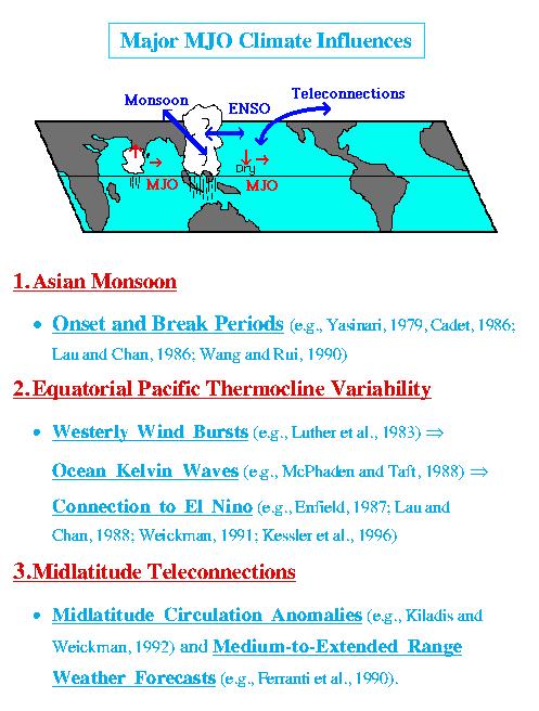
2 Madden and Julian Oscillation (MJO) Since its discovery by Madden and Julian (1971) over two decades ago, the Madden and Julian Oscillation (MJO) has continued to be a topic of significant interest due to its complex nature and the wide range of phenomena it interacts with (Madden and Julian, 1994). The onset and activity of the Asian-Australian monsoon system are strongly influenced by the eastward propagation of MJO events (e.g., Yasunari, 1979; Lau and Chan, 1986). The interaction of the MJO with the extra-tropical regions has been shown to influence weather forecasts on medium-to-extended range (Ferranti et al. 1990; Lau and Chang, 1992). Furthermore, coupling with the tropical ocean via westerly wind bursts associated with the passage of an MJO significantly modify sea surface temperature (SST), surface heat fluxes (Kawamura, 1991; Zhang, 1996; Jones and Weare, 1996; Flatau et al., 1997; Jones et al. 1998; Hendon and Glick, 1997) and the structure of the thermocline in the equatorial Pacific Ocean (Kessler et al., 1996). This latter interaction has even been suggested to play an important role in triggering ENSO events (e.g., Lau and Chan, 1986; Weickmann, 1991). Another important aspect of the MJO that has received relatively less attention concerns the predictability of intraseasonal variations. Enormous progress has been achieved in mid-latitude short-term weather forecasting over the last 30 years (e.g., Van den Dool, 1994) with useful predictability out to 6-10 days being exploited every day. At longer time scales, interannual variability is the next form of climate prediction that has been demonstrated, as well as become operational and useful. In between these two time scales, the MJO phenomenon stands out as the next candidate with potential for predictability (e.g., Lau and Chang, 1992; Waliser et al., 1999). In an early study, Chen and Alpert (1990) showed that when the MJO amplitude is large, model forecast skill of its propagation and amplitude were quite good out to 10 days. However, when the MJO amplitude was small, the forecast skill was poor. In another study, Ferranti et al. (1990) demonstrated that the skill of medium-to-extended range forecasts in the extra-tropics are significantly improved when the errors associated with the representation of the tropical intraseasonal oscillation are minimized. Lau and Chang (1992) analyzed one season of 30-day global forecasts derived from the National Centers for Environmental Prediction (NCEP) forecast model during the Dynamical Extended Range Forecasts (DERF) experiment. Their results show that the NCEP forecast model has significant skill in predicting the global pattern of intraseasonal variability up to 10 days, with the error growth of tropical and extratropical low-frequency modes less (greater) than persistence when the amplitude of the MJO is large (small). Jones et al. (2000) examined 5 years of 50-day forecasts during a Dynamical Extended-Range Forecast (DERF) experiment performed with the NCEP Medium Range Forecast (MRF) model. The MRF model shows large mean errors in representing tropical intraseasonal variations, especially over the equatorial eastern Pacific Ocean. A diagnostic analysis indicates that skillful forecasts extend only 5 to 7 days lead-time. The analysis showed systematic errors in the representation of the MJO with weaker than observed upper level zonal circulations. References can be accessed at:


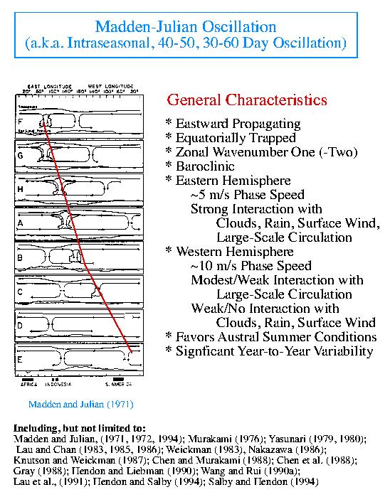
3 The Madden-Julian Oscillation Madden and Julian (1972)
4 Outgoing Longwave Radiation Climatology T C T S T C < T S

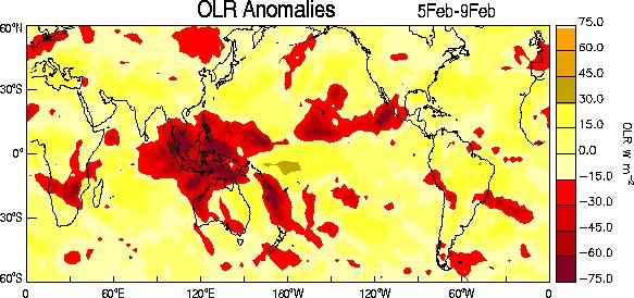
5 OLR Data are filtered in time (20-90 days) and composites of OLR anomalies are made Enhanced Tropical Convection Suppressed Tropical Convection

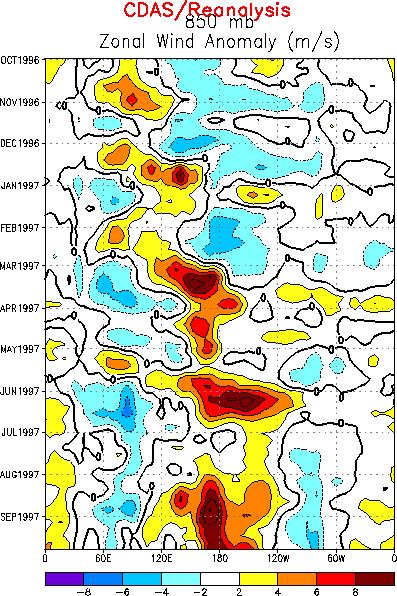
6 Zonal (U) wind component (850 hpa) is filtered in time (20-90 days) and composites of anomalies are made Enhanced easterlies Enhanced westerlies

7 Outgoing Longwave Radiation Climatology
8
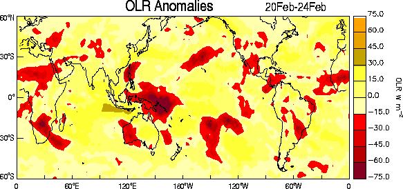
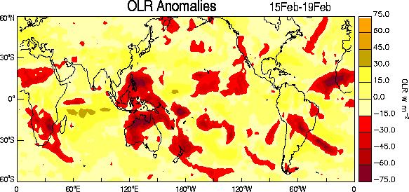
9 Tropical Intraseasonal Oscillations, MJO and the Pineapple Express There is significant evidence that a large fraction of the precipitation and surface air temperature variability over North America during the boreal winter and summer seasons are linked to tropical variations on interannual and intraseasonal time scales. The impacts of ENSO in the U.S. have been extensively documented (Barston et al., 1999; Changnon 1999). In addition to changes in mean seasonal values, the tropical influence is also felt on extreme events. Extreme precipitation episodes in the western United States (those in the top 10% of all events) occur at all phases of the El Niño- Southern Oscillation (ENSO) cycle, but the largest fraction of these events (for the West Coast as a whole) occurs during neutral winters between cold and warm ENSO episodes (Higgins et al. 2000a). In the tropical Pacific, these winters are characterized by enhanced day intraseasonal (MJO) activity. Furthermore, they are characterized by relatively small sea surface temperature anomalies (SSTA) compared to ENSO winters. In these winter seasons, there is a stronger linkage between the MJO events and extreme west coast precipitation episodes. During the winter season specifically, Persistent North Pacific (PNP) circulation anomalies have been linked to tropical intraseasonal variations. The typical scenario linking the pattern of tropical rainfall associated with the MJO to extreme precipitation events along the west coast is characterized by a progressive (i.e. eastward moving) circulation pattern in the tropics and a retrograding (i.e. westward moving) circulation pattern in the midlatitudes of the North Pacific. Typical wintertime weather anomalies preceding heavy precipitation events in the Pacific Northwest are as follows (Fig. 1): 7-10 days prior to the event: Heavy tropical rainfall associated with the MJO shifts eastward from the eastern Indian Ocean to the western tropical Pacific. A moisture plume extends northeastward from the western tropical Pacific towards the general vicinity of the Hawaiian Islands. A strong blocking anticyclone is located in the Gulf of Alaska with a strong polar jet stream around its northern flank. 3-5 days prior to the event: Heavy tropical rainfall shifts eastward towards the date line and begins to diminish. The associated moisture plume extends further to the northeast, often traversing the Hawaiian Islands. The strong blocking high weakens and shifts westward. A split in the North Pacific jet stream develops, characterized by an increase in the amplitude and spatial extent of the upper tropospheric westerly zonal winds on the southern flank of the block and a decrease on its northern flank. The tropical and extratropical circulation patterns begin to phase allowing a developing midlatitude trough to tap the moisture plume extending from the deep tropics.

10 Tropical-Extratropical Interaction associated with Madden-Julian Oscillation Figure 1. Schematic representation of eastward propagation of tropical convective anomalies associated with the Madden-Julian Oscillation, changes in the Jet Stream and precipitation events in the Pacific Northwest. Precipitation event: The pattern of enhanced tropical rainfall shifts further to the east and weakens. The deep tropical moisture plume extends from the subtropical central Pacific into the midlatitude trough located off the west coast of North America. The jet stream at upper levels extends across the North Pacific with the mean jet position entering North America in the northwestern United States. Deep low pressure located near the Pacific Northwest coast can bring up to several days of heavy rain and possible flooding. The tropical moisture plumes are often referred to as pineapple express events by the weather forecasting community, so named because significant amounts of the deep tropical moisture traverse the Hawaiian Islands on its way towards western North America. Throughout the evolution, retrogression of the large-scale atmospheric circulation features is observed in the eastern Pacific-North American sector. Many of these events are characterized by the progression of the heaviest precipitation from south to north along the Pacific Northwest coast over a period of several days to more than one week. However, it is important to differentiate the individual synoptic-scale storms, which generally move west to east, from the overall large-scale pattern, which exhibits retrogression. Since there is considerable case-to-case variability in these events, the above scenario should be viewed as typical.
11
12
13 Occurrence of Extreme Precipitation Events in California and Relationships with the Madden-Julian Oscillation Motivation High frequency of Intense rainfall can lead to damaging floods Precipitation in the western United States is modulated by tropical variability Interannual: ENSO Intraseasonal: eastward propagation of the MJO modulates precipitation in California; location of convective anomalies favors wet (dry) events Are Extreme events in California more likely during active periods of the MJO?
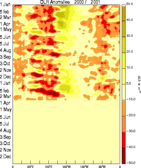
14 Data Sets Tropical Convection: 5-day averages of Outgoing Longwave Radiation (OLR) (Jan Dec 1996) Zonal Circulation: 5-day averages of U at 200 and 850 mb from NCEP/NCAR reanalyses (Jan Dec 1996) MJO: band-pass Lanczos filter (20-90) days Daily observed precipitation from gridded hourly station data (2.0 lat x 2.5 lon). Jan 1958-Dec 1996 Select six grid boxes over California; Compute 5-day total precipitation Definition of Extreme Event Type-I: 5-day total precipitation 5% of the average annual Type-II: 5-day total 10% average annual precipitation Type-III: 5-day total 15% average annual precipitation

15 Influence of the MJO on Extreme Rainfall Events in California The occurrences of extreme precipitation events in California were also investigated by Jones (2000). Daily-observed precipitation from gridded hourly station data from January 1958 to December 1996 was used to define extreme events. Based on 5-day precipitation totals, three types of extreme events were defined. Type I was defined when the 5-day total precipitation exceeded 5% of the total annual precipitation, type II if the 5-day total precipitation exceeded 10% of the total annual precipitation and type III if the 5-day total precipitation exceeded 15% of the total annual precipitation. In order to investigate possible linkages between extreme precipitation events and the activity of the MJO, six gridboxes were selected over the state of California. The number of extreme events in each of the six grid boxes was counted for the active and inactive MJO periods defined by the lag composites of U850 anomalies. The figure below shows the total number of occurrences of extreme events of types I and II during active and inactive MJO periods (expressed as percentages from the sample size). The results show that more than twice as many extreme precipitation events of types I and II occur in Central and Southern California when tropical circulation anomalies are large and associated with the MJO. (a) Percentage of Occurence of Type-I Extrem e Events (5%) (b) Percentage of Occurrence of Type-II Extrem e Events (10%) Percentage Box 1 Box 2 Box 3 Box 4 Box 5 Box 65 Box 1 Box 2 Box 3 Box 4 Box 5 Box 56 Percentage Active MJO (Lag -2) Inactive MJO Active MJO (lag -2) Inactive M JO (a) Percentage of Type-I (5%) extreme events that occur during active and inactive MJO periods. (b) Same as in (a), but for Type-II (10%) events. Sample sizes are 439 pentads for active MJO and 356 pentads inactive MJO. Percentages are expressed as occurrences from the sample size. The locations of each grid box are shown in the inset in (b) (After Jones, 2000).
16 Dynamical Prediction of the Madden-Julian Oscillation Our ability to forecast the tropical intraseasonal oscillation with dynamical models is still quite limited. Jones et al (2000) examined 5 years of 50-day forecasts during a Dynamical Extended-Range Forecast (DERF) experiment performed with the NCEP Medium Range Forecast (MRF) model. The MRF model shows large mean errors in representing tropical intraseasonal variations, especially over the equatorial eastern Pacific Ocean. A diagnostic analysis indicates that skillful forecasts extend only 5 to 7 days lead-time. The analysis showed systematic errors in the representation of the MJO with weaker than observed upper level zonal circulations. Waliser et al. (1999), for instance, developed a statistical model based on field-to-field decomposition of pentads of bandpassed outgoing longwave radiation (OLR). The statistical model has significant skill in predicting the oscillation over the Eastern Hemisphere at lead-times from 5 to 20 days. 1Jan85 20Feb 31Dec89 Forecast Lead Time (in Days) Days 50 days Lorenz Block
17 (a) Zonal average of the anomaly correlations in U (200 hpa) shown in Figs. 8 and 9 and the different phases of the MJO: PC1 - (dotted), PC2 - (dashed), PC1 + (dash-dotted) and PC2 + (long dash-short dash). Also displayed is the zonal average for the Null case (solid). (b) Zonal average of the anomaly correlations between verification and forecasts of U (200 hpa) obtained by persistence. Persistence is calculated using all days in the four winter seasons and shown for unfiltered (solid) and filtered (dotted) time series.

18 MJO - DERF Forecast /88 OLR: Red < 5 W m -2 U200: Red < 2 m s -1
19 Statistical Prediction of the MJO Waliser, Jones, Schemm and Graham Band-passed (30-70 days) OLR pentads ( ) Predictors: two most recent pentad maps T N-1 T N Predictands: future OLR pentads T N+1, T N+2 T N+9 Method: For each T N+ j, j=1,9 Singular Value Decomposition (SVD) between all the predictor sets (T N-1, T N ) and the predictands (T N+ j ) Provides a set of modes for each lead time SVD procedure performed on first 11 years of data and tested on the remainder 7 years

20 Time-longitude plots of 3-pentad 3 OLR prediction (right; "Pentad0 + 3"), along with validating total (left) and band-passed (center) OLR anomalies, for 1992 northern hemisphere "winter". Data are averaged between 10 o S and 10 o N. Negative OLR values are shaded and indicate positive rainfall anomalies. Lines at 150 o E extending from the beginning of the period through February indicate the overlapping g COARE Intensive Observation Period at the site of the central IMET ocean / surface flux mooring.
21 Real-Time Long-Range Statistical Forecasts of the Western United States Rainfall Statistical Forecasts of Intraseasonal and Seasonal Variations of Precipitation and Temperature over the Western United States Funding Agency: NOAA-CLIVAR-Pacific Program Principal Investigator: Dr. Charles Jones Abstract One of the main scientific goals of the Climate Variability and Predictability Pacific Program (CLIVAR-Pacific) is to determine and test hypotheses for improving seasonal-to-interannual prediction. The CLIVAR program also motivates the examination of the influence of intraseasonal variations on seasonal predictability. The main goal of this project is to investigate the intraseasonal and seasonal predictability of precipitation (P) and surface air temperature (Ta) over the western United States. The objectives are: 1) Implement experimental real-time statistical forecasts of the Madden-Julian Oscillation (MJO); 2) Determine the relative importance of tropical intraseasonal (MJO) and interannual (ENSO) variations in accounting for intraseasonal predictability of P and Ta. 3) Assess the contribution of seasonal variations in the MJO activity to the seasonal predictability of P and Ta. 4) Implement experimental real-time statistical intraseasonal and seasonal forecasts of P and Ta.

22 Example of possible tropical-intraseasonal interaction associated with MJO
23
24
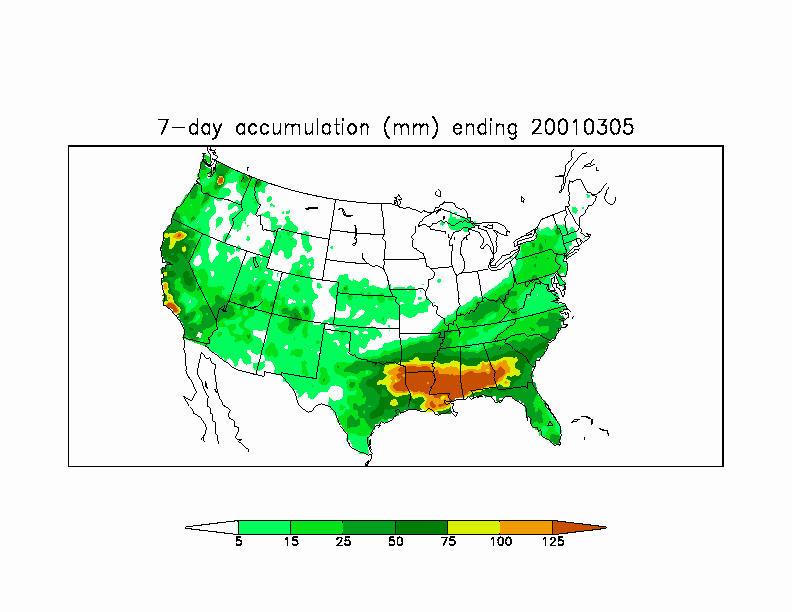
25 March 5, 2001 Current Rainfall Data: For past 24 hours as of 8:00 a.m on date indicated March 5, Amounts are preliminary and subject to change. Santa Barbara County Public Works Dept.
26


27 Work is in progress to: Develop real-time statistical forecasts of the MJO Develop real-time statistical forecasts of rainfall Further information about this research can be accessed at:
The Influence of Intraseasonal Variations on Medium- to Extended-Range Weather Forecasts over South America
 486 MONTHLY WEATHER REVIEW The Influence of Intraseasonal Variations on Medium- to Extended-Range Weather Forecasts over South America CHARLES JONES Institute for Computational Earth System Science (ICESS),
ENSO Cycle: Recent Evolution, Current Status and Predictions. Update prepared by Climate Prediction Center / NCEP 11 November 2013
 ENSO Cycle: Recent Evolution, Current Status and Predictions Update prepared by Climate Prediction Center / NCEP 11 November 2013 Outline Overview Recent Evolution and Current Conditions Oceanic Niño Index
ENSO Cycle: Recent Evolution, Current Status and Predictions. Update prepared by Climate Prediction Center / NCEP 23 April 2012
 ENSO Cycle: Recent Evolution, Current Status and Predictions Update prepared by Climate Prediction Center / NCEP 23 April 2012 Outline Overview Recent Evolution and Current Conditions Oceanic Niño Index
ENSO Cycle: Recent Evolution, Current Status and Predictions. Update prepared by Climate Prediction Center / NCEP 25 February 2013
 ENSO Cycle: Recent Evolution, Current Status and Predictions Update prepared by Climate Prediction Center / NCEP 25 February 2013 Outline Overview Recent Evolution and Current Conditions Oceanic Niño Index
ENSO Cycle: Recent Evolution, Current Status and Predictions. Update prepared by Climate Prediction Center / NCEP 15 July 2013
 ENSO Cycle: Recent Evolution, Current Status and Predictions Update prepared by Climate Prediction Center / NCEP 15 July 2013 Outline Overview Recent Evolution and Current Conditions Oceanic Niño Index
ENSO Cycle: Recent Evolution, Current Status and Predictions. Update prepared by Climate Prediction Center / NCEP 5 August 2013
 ENSO Cycle: Recent Evolution, Current Status and Predictions Update prepared by Climate Prediction Center / NCEP 5 August 2013 Outline Overview Recent Evolution and Current Conditions Oceanic Niño Index
Vertical Moist Thermodynamic Structure of the MJO in AIRS Observations: An Update and A Comparison to ECMWF Interim Reanalysis
 Vertical Moist Thermodynamic Structure of the MJO in AIRS Observations: An Update and A Comparison to ECMWF Interim Reanalysis Baijun Tian 1 Duane Waliser 1, Eric Fetzer 1, and Yuk Yung 2 1.Jet Propulsion
ENSO: Recent Evolution, Current Status and Predictions. Update prepared by: Climate Prediction Center / NCEP 9 November 2015
 ENSO: Recent Evolution, Current Status and Predictions Update prepared by: Climate Prediction Center / NCEP 9 November 2015 Outline Summary Recent Evolution and Current Conditions Oceanic Niño Index (ONI)
Introduction of products for Climate System Monitoring
 Introduction of products for Climate System Monitoring 1 Typical flow of making one month forecast Textbook P.66 Observed data Atmospheric and Oceanic conditions Analysis Numerical model Ensemble forecast
ENSO Cycle: Recent Evolution, Current Status and Predictions. Update prepared by Climate Prediction Center / NCEP 24 September 2012
 ENSO Cycle: Recent Evolution, Current Status and Predictions Update prepared by Climate Prediction Center / NCEP 24 September 2012 Outline Overview Recent Evolution and Current Conditions Oceanic Niño
ENSO: Recent Evolution, Current Status and Predictions. Update prepared by: Climate Prediction Center / NCEP 30 October 2017
 ENSO: Recent Evolution, Current Status and Predictions Update prepared by: Climate Prediction Center / NCEP 30 October 2017 Outline Summary Recent Evolution and Current Conditions Oceanic Niño Index (ONI)
Introduction of climate monitoring and analysis products for one-month forecast
 Introduction of climate monitoring and analysis products for one-month forecast TCC Training Seminar on One-month Forecast on 13 November 2018 10:30 11:00 1 Typical flow of making one-month forecast Observed
ENSO Cycle: Recent Evolution, Current Status and Predictions. Update prepared by Climate Prediction Center / NCEP July 26, 2004
 ENSO Cycle: Recent Evolution, Current Status and Predictions Update prepared by Climate Prediction Center / NCEP July 26, 2004 Outline Overview Recent Evolution and Current Conditions Oceanic NiZo Index
What is the Madden-Julian Oscillation (MJO)?
?") What is the Madden-Julian Oscillation (MJO)? Planetary scale, 30 90 day oscillation in zonal wind, precipitation, surface pressure, humidity, etc., that propagates slowly eastward Wavelength = 12,000 20,000
What is the Madden-Julian Oscillation (MJO)? Planetary scale, 30 90 day oscillation in zonal wind, precipitation, surface pressure, humidity, etc., that propagates slowly eastward Wavelength = 12,000 20,000
David W. Reynolds * National Weather Service WFO San Francisco Bay Area Monterey, CA
 3.2 THE MADDEN JULIAN OSCILLATION: ITS POTENTIAL FOR WEEK TWO FLOOD OUTLOOKS AND RESERVOIR MANAGEMENT DECISIONS IN CALIFORNIA David W. Reynolds * National Weather Service WFO San Francisco Bay Area Monterey,
KUALA LUMPUR MONSOON ACTIVITY CENT
 T KUALA LUMPUR MONSOON ACTIVITY CENT 2 ALAYSIAN METEOROLOGICAL http://www.met.gov.my DEPARTMENT MINISTRY OF SCIENCE. TECHNOLOGY AND INNOVATIO Introduction Atmospheric and oceanic conditions over the tropical
Thai Meteorological Department, Ministry of Digital Economy and Society
 Thai Meteorological Department, Ministry of Digital Economy and Society Three-month Climate Outlook For November 2017 January 2018 Issued on 31 October 2017 -----------------------------------------------------------------------------------------------------------------------------
Introduction of Seasonal Forecast Guidance. TCC Training Seminar on Seasonal Prediction Products November 2013
 Introduction of Seasonal Forecast Guidance TCC Training Seminar on Seasonal Prediction Products 11-15 November 2013 1 Outline 1. Introduction 2. Regression method Single/Multi regression model Selection
August Description of an MJO forecast metric.
 1956-30 Targeted Training Activity: Seasonal Predictability in Tropical Regions to be followed by Workshop on Multi-scale Predictions of the Asian and African Summer Monsoon 4-15 August 2008 Description
Lecture 8: Natural Climate Variability
 Lecture 8: Natural Climate Variability Extratropics: PNA, NAO, AM (aka. AO), SAM Tropics: MJO Coupled A-O Variability: ENSO Decadal Variability: PDO, AMO Unforced vs. Forced Variability We often distinguish
ENSO Outlook by JMA. Hiroyuki Sugimoto. El Niño Monitoring and Prediction Group Climate Prediction Division Japan Meteorological Agency
 ENSO Outlook by JMA Hiroyuki Sugimoto El Niño Monitoring and Prediction Group Climate Prediction Division Outline 1. ENSO impacts on the climate 2. Current Conditions 3. Prediction by JMA/MRI-CGCM 4. Summary
Seasonal Climate Outlook for South Asia (June to September) Issued in May 2014
 Issued in May 2014") Ministry of Earth Sciences Earth System Science Organization India Meteorological Department WMO Regional Climate Centre (Demonstration Phase) Pune, India Seasonal Climate Outlook for South Asia (June
Ministry of Earth Sciences Earth System Science Organization India Meteorological Department WMO Regional Climate Centre (Demonstration Phase) Pune, India Seasonal Climate Outlook for South Asia (June
The feature of atmospheric circulation in the extremely warm winter 2006/2007
 The feature of atmospheric circulation in the extremely warm winter 2006/2007 Hiroshi Hasegawa 1, Yayoi Harada 1, Hiroshi Nakamigawa 1, Atsushi Goto 1 1 Climate Prediction Division, Japan Meteorological
Variability of West African Weather Systems. Chris Thorncroft Department of Atmospheric and Environmental Sciences University at Albany
 Variability of West African Weather Systems Chris Thorncroft Department of Atmospheric and Environmental Sciences University at Albany Variability of West African Weather Systems (1) Convectively Coupled
Verification of the Seasonal Forecast for the 2005/06 Winter
 Verification of the Seasonal Forecast for the 2005/06 Winter Shingo Yamada Tokyo Climate Center Japan Meteorological Agency 2006/11/02 7 th Joint Meeting on EAWM Contents 1. Verification of the Seasonal
Analysis of Fall Transition Season (Sept-Early Dec) Why has the weather been so violent?
 Why has the weather been so violent?") WEATHER TOPICS Analysis of Fall Transition Season (Sept-Early Dec) 2009 Why has the weather been so violent? As can be seen by the following forecast map, the Fall Transition and early Winter Season of
WEATHER TOPICS Analysis of Fall Transition Season (Sept-Early Dec) 2009 Why has the weather been so violent? As can be seen by the following forecast map, the Fall Transition and early Winter Season of
UPDATE OF REGIONAL WEATHER AND SMOKE HAZE (December 2017)
") UPDATE OF REGIONAL WEATHER AND SMOKE HAZE (December 2017) 1. Review of Regional Weather Conditions for November 2017 1.1 In November 2017, Southeast Asia experienced inter-monsoon conditions in the first
UPDATE OF REGIONAL WEATHER AND SMOKE HAZE (December 2017) 1. Review of Regional Weather Conditions for November 2017 1.1 In November 2017, Southeast Asia experienced inter-monsoon conditions in the first
Available online at ScienceDirect. Procedia Environmental Sciences 33 (2016 ) Rahmat Hidayat*
 Rahmat Hidayat*") Available online at www.sciencedirect.com ScienceDirect Procedia Environmental Sciences 33 (2016 ) 167 177 The 2 nd International Symposium on LAPAN-IPB Satellite for Food Security and Environmental Monitoring
Available online at www.sciencedirect.com ScienceDirect Procedia Environmental Sciences 33 (2016 ) 167 177 The 2 nd International Symposium on LAPAN-IPB Satellite for Food Security and Environmental Monitoring
El Niño Seasonal Weather Impacts from the OLR Event Perspective
 Science and Technology Infusion Climate Bulletin NOAA s National Weather Service 41 st NOAA Annual Climate Diagnostics and Prediction Workshop Orono, ME, 3-6 October 2016 2015-16 El Niño Seasonal Weather
Global Climate Patterns and Their Impacts on North American Weather
 Global Climate Patterns and Their Impacts on North American Weather By Julie Malmberg and Jessica Lowrey, Western Water Assessment Introduction This article provides a broad overview of various climate
UPDATE OF REGIONAL WEATHER AND SMOKE HAZE (February 2018)
") UPDATE OF REGIONAL WEATHER AND SMOKE HAZE (February 2018) 1. Review of Regional Weather Conditions for January 2018 1.1 The prevailing Northeast monsoon conditions over Southeast Asia strengthened in January
UPDATE OF REGIONAL WEATHER AND SMOKE HAZE (February 2018) 1. Review of Regional Weather Conditions for January 2018 1.1 The prevailing Northeast monsoon conditions over Southeast Asia strengthened in January
North Pacific Climate Overview N. Bond (UW/JISAO), J. Overland (NOAA/PMEL) Contact: Last updated: September 2008
, J. Overland (NOAA/PMEL) Contact: Last updated: September 2008") North Pacific Climate Overview N. Bond (UW/JISAO), J. Overland (NOAA/PMEL) Contact: Nicholas.Bond@noaa.gov Last updated: September 2008 Summary. The North Pacific atmosphere-ocean system from fall 2007
North Pacific Climate Overview N. Bond (UW/JISAO), J. Overland (NOAA/PMEL) Contact: Nicholas.Bond@noaa.gov Last updated: September 2008 Summary. The North Pacific atmosphere-ocean system from fall 2007
MJO Influence in Continental United States Temperatures
 MJO Influence in Continental United States Temperatures An honors thesis presented to the Department of Atmospheric Science, University at Albany, State University Of New York in partial fulfillment of
NOAA 2015 Updated Atlantic Hurricane Season Outlook
 NOAA 2015 Updated Atlantic Hurricane Season Outlook Dr. Gerry Bell Lead Seasonal Forecaster Climate Prediction Center/ NOAA/ NWS Collaboration With National Hurricane Center/ NOAA/ NWS Hurricane Research
IAP Dynamical Seasonal Prediction System and its applications
 WCRP Workshop on Seasonal Prediction 4-7 June 2007, Barcelona, Spain IAP Dynamical Seasonal Prediction System and its applications Zhaohui LIN Zhou Guangqing Chen Hong Qin Zhengkun Zeng Qingcun Institute
Anticorrelated intensity change of the quasi-biweekly and day oscillations over the South China Sea
 Click Here for Full Article GEOPHYSICAL RESEARCH LETTERS, VOL. 35, L16702, doi:10.1029/2008gl034449, 2008 Anticorrelated intensity change of the quasi-biweekly and 30 50-day oscillations over the South
Seasonal Climate Watch January to May 2016
 Seasonal Climate Watch January to May 2016 Date: Dec 17, 2015 1. Advisory Most models are showing the continuation of a strong El-Niño episode towards the latesummer season with the expectation to start
Techniques and experiences in real-time prediction of the MJO: The BMRC perspective
 Techniques and experiences in real-time prediction of the MJO: The BMRC perspective Matthew Wheeler, Harry Hendon, and Oscar Alves Bureau of Meteorology Research Centre P.O. Box 1289k, Melbourne, Vic,
The Association between Intraseasonal Oscillations and Tropical Storms in the Atlantic Basin
 4097 The Association between Intraseasonal Oscillations and Tropical Storms in the Atlantic Basin KINGTSE C. MO Climate Prediction Center, NCEP/NWS/NOAA, Camp Springs, Maryland (Manuscript received 4 October
Example of the one month forecast
 Example of the one month forecast Masayuki Hirai Tokyo Climate Center (TCC)/ Climate Prediction Division of Japan Meteorological Agency (JMA) Example Note that the initial time and the forecast target
Wind: Global Systems Chapter 10
 Wind: Global Systems Chapter 10 General Circulation of the Atmosphere General circulation of the atmosphere describes average wind patterns and is useful for understanding climate Over the earth, incoming
ANNUAL CLIMATE REPORT 2016 SRI LANKA
 ANNUAL CLIMATE REPORT 2016 SRI LANKA Foundation for Environment, Climate and Technology C/o Mahaweli Authority of Sri Lanka, Digana Village, Rajawella, Kandy, KY 20180, Sri Lanka Citation Lokuhetti, R.,
Conference on Teleconnections in the Atmosphere and Oceans November 2008
 1968-38 Conference on Teleconnections in the Atmosphere and Oceans 17-20 November 2008 Mid-latitude - MJO teleconnection over East Asia in the Northern winter KIM Baekmin Yonsei University Dept. of Atmospheric
CHAPTER 2 DATA AND METHODS. Errors using inadequate data are much less than those using no data at all. Charles Babbage, circa 1850
 CHAPTER 2 DATA AND METHODS Errors using inadequate data are much less than those using no data at all. Charles Babbage, circa 185 2.1 Datasets 2.1.1 OLR The primary data used in this study are the outgoing
El Niño Update Impacts on Florida
 Current Issues in Emergency Management (CIEM) Sessions 1 &2 October 12 th and 26 th, 2006 Florida Division of Emergency Management Tallahassee, Florida El Niño Update Impacts on Florida Bart Hagemeyer
The Madden Julian Oscillation in the ECMWF monthly forecasting system
 The Madden Julian Oscillation in the ECMWF monthly forecasting system Frédéric Vitart ECMWF, Shinfield Park, Reading RG2 9AX, United Kingdom F.Vitart@ecmwf.int ABSTRACT A monthly forecasting system has
El Niño, South American Monsoon, and Atlantic Niño links as detected by a. TOPEX/Jason Observations
 El Niño, South American Monsoon, and Atlantic Niño links as detected by a decade of QuikSCAT, TRMM and TOPEX/Jason Observations Rong Fu 1, Lei Huang 1, Hui Wang 2, Paola Arias 1 1 Jackson School of Geosciences,
North Pacific Climate Overview N. Bond (UW/JISAO), J. Overland (NOAA/PMEL) Contact: Last updated: August 2009
, J. Overland (NOAA/PMEL) Contact: Last updated: August 2009") North Pacific Climate Overview N. Bond (UW/JISAO), J. Overland (NOAA/PMEL) Contact: Nicholas.Bond@noaa.gov Last updated: August 2009 Summary. The North Pacific atmosphere-ocean system from fall 2008 through
North Pacific Climate Overview N. Bond (UW/JISAO), J. Overland (NOAA/PMEL) Contact: Nicholas.Bond@noaa.gov Last updated: August 2009 Summary. The North Pacific atmosphere-ocean system from fall 2008 through
Tropical drivers of the Antarctic atmosphere
 Tropical drivers of the Antarctic atmosphere Bradford S. Barrett Gina R. Henderson Oceanography Department U. S. Naval Academy Acknowledge support of: NSF awards ARC-1203843 and AGS-1240143 ONR award N1416WX01752
Jiangyu Mao Æ Zhang Sun Æ Guoxiong Wu
 Clim Dyn (2010) 34:747 761 DOI 10.1007/s00382-009-0628-2 20 50-day oscillation of summer Yangtze rainfall in response to intraseasonal variations in the subtropical high over the western North Pacific
Special blog on winter 2016/2017 retrospective can be found here -
 March 4, 2019 Special blog on winter 2016/2017 retrospective can be found here - http://www.aer.com/winter2017 Special blog on winter 2015/2016 retrospective can be found here - http://www.aer.com/winter2016
CHAPTER 9 ATMOSPHERE S PLANETARY CIRCULATION MULTIPLE CHOICE QUESTIONS
 CHAPTER 9 ATMOSPHERE S PLANETARY CIRCULATION MULTIPLE CHOICE QUESTIONS 1. Viewed from above in the Northern Hemisphere, surface winds about a subtropical high blow a. clockwise and inward. b. counterclockwise.
La Niña impacts on global seasonal weather anomalies: The OLR perspective. Andrew Chiodi and Ed Harrison
 La Niña impacts on global seasonal weather anomalies: The OLR perspective Andrew Chiodi and Ed Harrison Outline Motivation Impacts of the El Nino- Southern Oscillation (ENSO) on seasonal weather anomalies
Delayed Response of the Extratropical Northern Atmosphere to ENSO: A Revisit *
 Delayed Response of the Extratropical Northern Atmosphere to ENSO: A Revisit * Ruping Mo Pacific Storm Prediction Centre, Environment Canada, Vancouver, BC, Canada Corresponding author s address: Ruping
Toward Seamless Weather-Climate Prediction with a Global Cloud Resolving Model
 DISTRIBUTION STATEMENT A. Approved for public release; distribution is unlimited. Toward Seamless Weather-Climate Prediction with a Global Cloud Resolving Model PI: Tim Li IPRC/SOEST, University of Hawaii
MPACT OF EL-NINO ON SUMMER MONSOON RAINFALL OF PAKISTAN
 MPACT OF EL-NINO ON SUMMER MONSOON RAINFALL OF PAKISTAN Abdul Rashid 1 Abstract: El-Nino is the dominant mod of inter- annual climate variability on a planetary scale. Its impact is associated worldwide
The ENSO s Effect on Eastern China Rainfall in the Following Early Summer
 ADVANCES IN ATMOSPHERIC SCIENCES, VOL. 26, NO. 2, 2009, 333 342 The ENSO s Effect on Eastern China Rainfall in the Following Early Summer LIN Zhongda ( ) andluriyu( F ) Center for Monsoon System Research,
Atmospheric circulation analysis for seasonal forecasting
 Training Seminar on Application of Seasonal Forecast GPV Data to Seasonal Forecast Products 18 21 January 2011 Tokyo, Japan Atmospheric circulation analysis for seasonal forecasting Shotaro Tanaka Climate
Chapter 1 Climate in 2016
 Chapter 1 Climate in 2016 1.1 Global climate summary Extremely high temperatures were frequently observed in many regions of the world, and in particular continued for most of the year in various places
1. Introduction. 2. Verification of the 2010 forecasts. Research Brief 2011/ February 2011
 Research Brief 2011/01 Verification of Forecasts of Tropical Cyclone Activity over the Western North Pacific and Number of Tropical Cyclones Making Landfall in South China and the Korea and Japan region
UPDATE OF REGIONAL WEATHER AND SMOKE HAZE (September 2017)
") UPDATE OF REGIONAL WEATHER AND SMOKE HAZE (September 2017) 1. Review of Regional Weather Conditions in August 2017 1.1 Southwest Monsoon conditions continued to prevail in the region in August 2017. The
UPDATE OF REGIONAL WEATHER AND SMOKE HAZE (September 2017) 1. Review of Regional Weather Conditions in August 2017 1.1 Southwest Monsoon conditions continued to prevail in the region in August 2017. The
The Madden Julian Oscillation and Its Impact on Northern Hemisphere Weather Predictability
 1462 MONTHLY WEATHER REVIEW VOLUME 132 The Madden Julian Oscillation and Its Impact on Northern Hemisphere Weather Predictability CHARLES JONES Institute for Computational Earth System Science, University
Introduction to tropical meteorology and deep convection
 Introduction to tropical meteorology and deep convection TMD Lecture 1 Roger K. Smith University of Munich A satpix tour of the tropics The zonal mean circulation (Hadley circulation), Inter- Tropical
CPTEC and NCEP Model Forecast Drift and South America during the Southern Hemisphere Summer
 CPTEC and NCEP Model Forecast Drift and South America during the Southern Hemisphere Summer José Antonio Aravéquia 1 Pedro L. Silva Dias 2 (1) Center for Weather Forecasting and Climate Research National
A Synoptic Climatology of Heavy Precipitation Events in California
 A Synoptic Climatology of Heavy Precipitation Events in California Alan Haynes Hydrometeorological Analysis and Support (HAS) Forecaster National Weather Service California-Nevada River Forecast Center
Evolution of Tropical Cyclone Characteristics
 Evolution of Tropical Cyclone Characteristics Patrick A. Harr Department of Meteorology Naval Postgraduate School Monterey, CA 93943-5114 Telephone : (831) 656-3787 FAX: (831) 656-3061 email: paharr@nps.navy.mil
The Madden-Julian Oscillation in General Circulation Models
 The Madden-Julian Oscillation in General Circulation Models Kenneth R. Sperber 1, Julia M. Slingo 2, Peter M. Inness 2, Silvio Gualdi 3, Wei Li 4, Peter J. Gleckler 1, Charles Doutriaux 1 and the AMIP
Climate Forecast Applications Network (CFAN)
") Forecast of 2018 Atlantic Hurricane Activity April 5, 2018 Summary CFAN s inaugural April seasonal forecast for Atlantic tropical cyclone activity is based on systematic interactions among ENSO, stratospheric
Forecast of 2018 Atlantic Hurricane Activity April 5, 2018 Summary CFAN s inaugural April seasonal forecast for Atlantic tropical cyclone activity is based on systematic interactions among ENSO, stratospheric
The North Atlantic Oscillation: Climatic Significance and Environmental Impact
 1 The North Atlantic Oscillation: Climatic Significance and Environmental Impact James W. Hurrell National Center for Atmospheric Research Climate and Global Dynamics Division, Climate Analysis Section
Quasi-Biennial Oscillation Modes Appearing in the Tropical Sea Water Temperature and 700mb Zonal Wind* By Ryuichi Kawamura
 December 1988 R. Kawamura 955 Quasi-Biennial Oscillation Modes Appearing in the Tropical Sea Water Temperature and 700mb Zonal Wind* By Ryuichi Kawamura Environmental Research Center University of Tsukuba
The 2005 North Atlantic Hurricane Season A Climate Perspective
 The 2005 North Atlantic Hurricane Season A Climate Perspective Gerald Bell 1, Eric Blake 2, Chris Landsea 2, Kingtse Mo 1, Richard Pasch 2, Muthuvel Chelliah 1, Stanley Goldenberg 3 1 Climate Prediction
Ocean-Atmosphere Interactions and El Niño Lisa Goddard
 Ocean-Atmosphere Interactions and El Niño Lisa Goddard Advanced Training Institute on Climatic Variability and Food Security 2002 July 9, 2002 Coupled Behavior in tropical Pacific SST Winds Upper Ocean
Climate Outlook for December 2015 May 2016
 The APEC CLIMATE CENTER Climate Outlook for December 2015 May 2016 BUSAN, 25 November 2015 Synthesis of the latest model forecasts for December 2015 to May 2016 (DJFMAM) at the APEC Climate Center (APCC),
Weakening relationship between East Asian winter monsoon and ENSO after mid-1970s
 Article Progress of Projects Supported by NSFC Atmospheric Science doi: 10.1007/s11434-012-5285-x Weakening relationship between East Asian winter monsoon and ENSO after mid-1970s WANG HuiJun 1,2* & HE
The Planetary Circulation System
 12 The Planetary Circulation System Learning Goals After studying this chapter, students should be able to: 1. describe and account for the global patterns of pressure, wind patterns and ocean currents
Lindzen et al. (2001, hereafter LCH) present
 present") NO EVIDENCE FOR IRIS BY DENNIS L. HARTMANN AND MARC L. MICHELSEN Careful analysis of data reveals no shrinkage of tropical cloud anvil area with increasing SST AFFILIATION: HARTMANN AND MICHELSEN Department
NO EVIDENCE FOR IRIS BY DENNIS L. HARTMANN AND MARC L. MICHELSEN Careful analysis of data reveals no shrinkage of tropical cloud anvil area with increasing SST AFFILIATION: HARTMANN AND MICHELSEN Department
Interannual Teleconnection between Ural-Siberian Blocking and the East Asian Winter Monsoon
 Interannual Teleconnection between Ural-Siberian Blocking and the East Asian Winter Monsoon Hoffman H. N. Cheung 1,2, Wen Zhou 1,2 (hoffmancheung@gmail.com) 1 City University of Hong Kong Shenzhen Institute
MAURITIUS METEOROLOGICAL SERVICES
 MAURITIUS METEOROLOGICAL SERVICES CLIMATE NOVEMBER 2018 Introduction Climatologically speaking, November is a relatively dry month for Mauritius with a long term monthly mean rainfall of 78 mm. However,
Will a warmer world change Queensland s rainfall?
 Will a warmer world change Queensland s rainfall? Nicholas P. Klingaman National Centre for Atmospheric Science-Climate Walker Institute for Climate System Research University of Reading The Walker-QCCCE
Predictability and prediction of the North Atlantic Oscillation
 Predictability and prediction of the North Atlantic Oscillation Hai Lin Meteorological Research Division, Environment Canada Acknowledgements: Gilbert Brunet, Jacques Derome ECMWF Seminar 2010 September
Intraseasonal Variation of Visibility in Hong Kong
 Intraseasonal Variation of Visibility in Hong Kong Wen Zhou, Richard Li and Eric Chow Guy Carpenter Asia-Pacific Climate Impact Center School of Energy and Environment, City University of Hong Kong Page
Global Ocean Monitoring: Recent Evolution, Current Status, and Predictions
 Global Ocean Monitoring: Recent Evolution, Current Status, and Predictions Prepared by Climate Prediction Center, NCEP November 6, 2009 http://www.cpc.ncep.noaa.gov/products/godas/ This project to deliver
Interannual Variability of the South Atlantic High and rainfall in Southeastern South America during summer months
 Interannual Variability of the South Atlantic High and rainfall in Southeastern South America during summer months Inés Camilloni 1, 2, Moira Doyle 1 and Vicente Barros 1, 3 1 Dto. Ciencias de la Atmósfera
Issued by the: Climate Services Division Fiji Meteorological Service Nadi Airport. 27 October 2010 GENERAL STATEMENT
 Fiji Meteorological Service (FMS) Tropical Cyclone Guidance for Season 2010/11 for the Fiji and the Southwest Pacific RSMC Region 160E to 120W Equator to 25 South Issued by the: Climate Services Division
The 2009 Hurricane Season Overview
 The 2009 Hurricane Season Overview Jae-Kyung Schemm Gerry Bell Climate Prediction Center NOAA/ NWS/ NCEP 1 Overview outline 1. Current status for the Atlantic, Eastern Pacific and Western Pacific basins
UPDATE OF REGIONAL WEATHER AND SMOKE HAZE (May 2017)
") UPDATE OF REGIONAL WEATHER AND SMOKE HAZE (May 2017) 1. Review of Regional Weather Conditions in April 2017 1.1 Inter monsoon conditions, characterised by afternoon showers and winds that are generally
UPDATE OF REGIONAL WEATHER AND SMOKE HAZE (May 2017) 1. Review of Regional Weather Conditions in April 2017 1.1 Inter monsoon conditions, characterised by afternoon showers and winds that are generally
Spring Heavy Rain Events in Taiwan during Warm Episodes and the Associated Large-Scale Conditions
 VOLUME 131 MONTHLY WEATHER REVIEW JULY 2003 Spring Heavy Rain Events in Taiwan during Warm Episodes and the Associated Large-Scale Conditions GEORGE TAI-JEN CHEN, ZHIHONG JIANG,* AND MING-CHIN WU Department
The Australian Summer Monsoon
 The Australian Summer Monsoon Aurel Moise, Josephine Brown, Huqiang Zhang, Matt Wheeler and Rob Colman Australian Bureau of Meteorology Presentation to WMO IWM-IV, Singapore, November 2017 Outline Australian
Mesoscale and High Impact Weather in the South American Monsoon Leila M. V. Carvalho 1 and Maria A. F. Silva Dias 2 1
 Mesoscale and High Impact Weather in the South American Monsoon Leila M. V. Carvalho 1 and Maria A. F. Silva Dias 2 1 University of California, Santa Barbara 2 University of Sao Paulo, Brazil Objectives
Diagnosing the Climatology and Interannual Variability of North American Summer Climate with the Regional Atmospheric Modeling System (RAMS)
") Diagnosing the Climatology and Interannual Variability of North American Summer Climate with the Regional Atmospheric Modeling System (RAMS) Christopher L. Castro and Roger A. Pielke, Sr. Department of
Diagnosing the Climatology and Interannual Variability of North American Summer Climate with the Regional Atmospheric Modeling System (RAMS) Christopher L. Castro and Roger A. Pielke, Sr. Department of
ENSO, AO, and climate in Japan. 15 November 2016 Yoshinori Oikawa, Tokyo Climate Center, Japan Meteorological Agency
 ENSO, AO, and climate in Japan 15 November 2016 Yoshinori Oikawa, Tokyo Climate Center, Japan Meteorological Agency Aims of this lecture At the end of the yesterday s lecture, Hare-run said, - In the exercise
Forecasting the MJO with the CFS: Factors affecting forecast skill of the MJO. Jon Gottschalck. Augustin Vintzileos
 Forecasting the MJO with the CFS: Factors affecting forecast skill of the MJO Augustin Vintzileos CPC/NCEP CICS/ESSIC, University of Maryland College Park Jon Gottschalck CPC/NCEP Problem statement: In
Possible Roles of Atlantic Circulations on the Weakening Indian Monsoon Rainfall ENSO Relationship
 2376 JOURNAL OF CLIMATE Possible Roles of Atlantic Circulations on the Weakening Indian Monsoon Rainfall ENSO Relationship C.-P. CHANG, PATRICK HARR, AND JIANHUA JU Department of Meteorology, Naval Postgraduate
Primary Factors Contributing to Japan's Extremely Hot Summer of 2010
 temperature anomalies by its standard deviation for JJA 2010 Primary Factors Contributing to Japan's Extremely Hot Summer of 2010 Nobuyuki Kayaba Climate Prediction Division,Japan Meteorological Agancy
Decadal Anomalies of Winter Precipitation over Southern China in Association with El Niño and La Niña
 NO.1 YUAN Yuan, LI Chongyin and YANG Song 91 Decadal Anomalies of Winter Precipitation over Southern China in Association with El Niño and La Niña YUAN Yuan 1 ( ), LI Chongyin 2,3 ( ), and YANG Song 4
New Zealand Climate Update No 223, January 2018 Current climate December 2017
 New Zealand Climate Update No 223, January 2018 Current climate December 2017 December 2017 was characterised by higher than normal sea level pressure over New Zealand and the surrounding seas. This pressure
Climate System Monitoring
 Climate System Monitoring Climate Prediction Division of JMA iroshi asegawa (h_hasegawa@met.kishou.go.jp) 1 Contents What is the climate system? Purpose of climate system monitoring View points for monitoring
El Niño / Southern Oscillation
 El Niño / Southern Oscillation Student Packet 2 Use contents of this packet as you feel appropriate. You are free to copy and use any of the material in this lesson plan. Packet Contents Introduction on
SPECIAL PROJECT PROGRESS REPORT
 SPECIAL PROJECT PROGRESS REPORT Progress Reports should be 2 to 10 pages in length, depending on importance of the project. All the following mandatory information needs to be provided. Reporting year
P2.11 DOES THE ANTARCTIC OSCILLATION MODULATE TROPICAL CYCLONE ACTIVITY IN THE NORTHWESTERN PACIFIC
 P2.11 DOES THE ANTARCTIC OSCILLATION MODULATE TROPICAL CYCLONE ACTIVITY IN THE NORTHWESTERN PACIFIC Joo-Hong Kim*, Chang-Hoi Ho School of Earth and Environmental Sciences, Seoul National University, Korea